North Carolina Geological Survey Publications List Mineral and Land...Economic Geology of the Spruce...
86
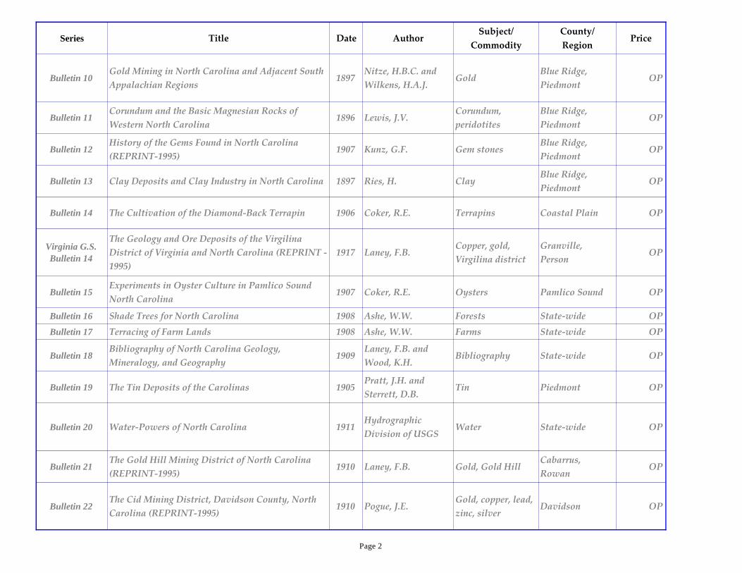
NC Geological Survey Publications List Available at our Online Store - click on it for link updated October 11, 2016 by Medina PDF copies of out-of-print publications available ------ email [email protected] for more details Series Title Date Author Subject/ Commodity County/ Region Price Bulletin 01 Iron Ores of North Carolina 1893 Nitze, H.B.C. Iron State-wide OP Bulletin 02 The Building and Ornamental Stones in North Carolina 1906 Watson, T.L. and Laney, F.B. Building stones State-wide OP Bulletin 03 Gold Deposits of North Carolina (REPRINT-1995) 1896 Nitze, H.B.C. and Hanna, G.B. Gold Blue Ridge, Piedmont OP Bulletin 04 Road Materials and Road Construction in North Carolina 1893 Holmes, J.A. and Cain, W. Roads State-wide OP Bulletin 05 The Forests, Forest Lands, and Forest Products of Eastern North Carolina 1894 Ashe, W.W. Forests Coastal Plain OP Bulletin 06 Timber Trees and Forests of North Carolina 1897 Pinchot, G. and Ashe, W.W. Forests State-wide OP Bulletin 07 Forest Fires: Their Destructive Work, Causes and Prevention 1895 Ashe, W.W. Forests State-wide OP Bulletin 08 Papers on the Waterpower in North Carolina 1899 Swain, G.F., Holmes, J.A. and Myers, E.W. Water State-wide OP Bulletin 09 Monazite and Monazite Deposits in North Carolina 1895 Nitze, H.B.C. Monazite Blue Ridge, Piedmont OP Page 1
Transcript of North Carolina Geological Survey Publications List Mineral and Land...Economic Geology of the Spruce...

NC Geological Survey Publications List
Available at our Online Store - click on it for link updated October 11, 2016 by Medina
PDF copies of out-of-print publications available ------ email [email protected] for more details
Series Title Date AuthorSubject/
Commodity
County/
RegionPrice
Bulletin 01 Iron Ores of North Carolina 1893 Nitze, H.B.C. Iron State-wide OP
Bulletin 02The Building and Ornamental Stones in North
Carolina1906
Watson, T.L. and
Laney, F.B.Building stones State-wide OP
Bulletin 03 Gold Deposits of North Carolina (REPRINT-1995) 1896Nitze, H.B.C. and
Hanna, G.B.Gold
Blue Ridge,
PiedmontOP
Bulletin 04Road Materials and Road Construction in North
Carolina1893
Holmes, J.A. and
Cain, W.Roads State-wide OP
Bulletin 05The Forests, Forest Lands, and Forest Products of
Eastern North Carolina1894 Ashe, W.W. Forests Coastal Plain OP
Bulletin 06 Timber Trees and Forests of North Carolina 1897Pinchot, G. and
Ashe, W.W.Forests State-wide OP
Bulletin 07Forest Fires: Their Destructive Work, Causes and
Prevention1895 Ashe, W.W. Forests State-wide OP
Bulletin 08 Papers on the Waterpower in North Carolina 1899
Swain, G.F.,
Holmes, J.A. and
Myers, E.W.
Water State-wide OP
Bulletin 09 Monazite and Monazite Deposits in North Carolina 1895 Nitze, H.B.C. MonaziteBlue Ridge,
PiedmontOP
Page 1
Series Title Date AuthorSubject/
Commodity
County/
RegionPrice
Bulletin 10Gold Mining in North Carolina and Adjacent South
Appalachian Regions1897
Nitze, H.B.C. and
Wilkens, H.A.J.Gold
Blue Ridge,
PiedmontOP
Bulletin 11Corundum and the Basic Magnesian Rocks of
Western North Carolina1896 Lewis, J.V.
Corundum,
peridotites
Blue Ridge,
PiedmontOP
Bulletin 12History of the Gems Found in North Carolina
(REPRINT-1995)1907 Kunz, G.F. Gem stones
Blue Ridge,
PiedmontOP
Bulletin 13 Clay Deposits and Clay Industry in North Carolina 1897 Ries, H. ClayBlue Ridge,
PiedmontOP
Bulletin 14 The Cultivation of the Diamond-Back Terrapin 1906 Coker, R.E. Terrapins Coastal Plain OP
Virginia G.S.
Bulletin 14
The Geology and Ore Deposits of the Virgilina
District of Virginia and North Carolina (REPRINT -
1995)
1917 Laney, F.B.Copper, gold,
Virgilina district
Granville,
PersonOP
Bulletin 15Experiments in Oyster Culture in Pamlico Sound
North Carolina1907 Coker, R.E. Oysters Pamlico Sound OP
Bulletin 16 Shade Trees for North Carolina 1908 Ashe, W.W. Forests State-wide OP
Bulletin 17 Terracing of Farm Lands 1908 Ashe, W.W. Farms State-wide OP
Bulletin 18Bibliography of North Carolina Geology,
Mineralogy, and Geography1909
Laney, F.B. and
Wood, K.H.Bibliography State-wide OP
Bulletin 19 The Tin Deposits of the Carolinas 1905Pratt, J.H. and
Sterrett, D.B.Tin Piedmont OP
Bulletin 20 Water-Powers of North Carolina 1911Hydrographic
Division of USGSWater State-wide OP
Bulletin 21The Gold Hill Mining District of North Carolina
(REPRINT-1995)1910 Laney, F.B. Gold, Gold Hill
Cabarrus,
RowanOP
Bulletin 22The Cid Mining District, Davidson County, North
Carolina (REPRINT-1995)1910 Pogue, J.E.
Gold, copper, lead,
zinc, silverDavidson OP
Page 2

Series Title Date AuthorSubject/
Commodity
County/
RegionPrice
Bulletin 23 Forest Conditions in Western North Carolina 1911 Holmes, J.S. Forests Mountains OP
Bulletin 24 Loblolly or North Carolina Pine 1915 Ashe, W.W. Forests State-wide OP
Bulletin 25Zircon, Monazite and Other Minerals Used in
Chemical Compounds Lighting Apparatus1916 Pratt, J.H. Zircon, monazite State-wide $3.00
Bulletin 26The Geology and Ore Deposits of the Virgilina
District of Virginia and North Carolina1917 Laney, F.B.
Copper, gold,
Virgilina district
Granville,
PersonOP
Bulletin 27 Altitudes in North Carolina 1917 Altitudes State-wide $3.00
Bulletin 28 Limestones and Marls of North Carolina 1921
Loughlin, G.F.,
Berry, E.W. and
Cushman, J.A.
Limestone, Marl Coastal Plain OP
Bulletin 29 The Kaolins of North Carolina 1925 Bayley, W.S. KaolinBlue Ridge,
Piedmont$3.00
Bulletin 30 Wood-Using Industries of North Carolina 1923Helphenstine Jr.,
R.K.Wood State-wide OP
Bulletin 31Deposits of Brown Iron Ores (Brown Hematite) in
Western North Carolina1925 Bayley, W.S. Iron Blue Ridge $3.00
Bulletin 32Magnetic Iron Ores of East Tennessee and Western
North Carolina1923 Bayley, W.S. Iron Blue Ridge OP
Bulletin 33 The Deep River Coal Field of North Carolina 1923Campbell, M.R. and
Kimball, K.W.
Coal, Deep River
Triassic basin
Chatham, Lee,
Moore$6.50
Bulletin 34Discharge Records of North Carolina Streams 1889-
19231925
Saville, T and
Smith, G.W.Water State-wide OP
Page 3
Series Title Date AuthorSubject/
Commodity
County/
RegionPrice
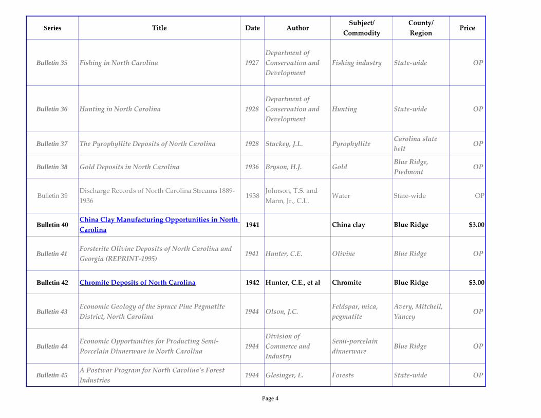
Bulletin 35 Fishing in North Carolina 1927
Department of
Conservation and
Development
Fishing industry State-wide OP
Bulletin 36 Hunting in North Carolina 1928
Department of
Conservation and
Development
Hunting State-wide OP
Bulletin 37 The Pyrophyllite Deposits of North Carolina 1928 Stuckey, J.L. PyrophylliteCarolina slate
beltOP
Bulletin 38 Gold Deposits in North Carolina 1936 Bryson, H.J. GoldBlue Ridge,
PiedmontOP
Bulletin 39Discharge Records of North Carolina Streams 1889-
19361938
Johnson, T.S. and
Mann, Jr., C.L.Water State-wide OP
Bulletin 40China Clay Manufacturing Opportunities in North
Carolina1941 China clay Blue Ridge $3.00
Bulletin 41Forsterite Olivine Deposits of North Carolina and
Georgia (REPRINT-1995)1941 Hunter, C.E. Olivine Blue Ridge OP
Bulletin 42 Chromite Deposits of North Carolina 1942 Hunter, C.E., et al Chromite Blue Ridge $3.00
Bulletin 43Economic Geology of the Spruce Pine Pegmatite
District, North Carolina1944 Olson, J.C.
Feldspar, mica,
pegmatite
Avery, Mitchell,
YanceyOP
Bulletin 44Economic Opportunities for Producting Semi-
Porcelain Dinnerware in North Carolina1944
Division of
Commerce and
Industry
Semi-porcelain
dinnerwareBlue Ridge OP
Bulletin 45A Postwar Program for North Carolina's Forest
Industries1944 Glesinger, E. Forests State-wide OP
Page 4

Series Title Date AuthorSubject/
Commodity
County/
RegionPrice
Bulletin 47Progress Report on Ground Water in North
Carolina1945 Mundorff, M.J. Ground water State-wide OP
Bulletin 48Residual Kaolin Deposits of the Spruce Pine
District, North Carolina1946 Parker, J.M., III Kaolin
Avery, Mitchell,
Yancey$3.00
Bulletin 49Mica Deposits of the Franklin-Sylva District,
North Carolina1946
Olson, J.C., and
othersMica Deposits Franklin $3.00
Bulletin 50 The Vermiculite Deposits of North Carolina 1946Murdock, T.G. and
Hunter, C.E.Vermiculite Blue Ridge $3.00
Bulletin 51 Ground Water in the Halifax Area, North Carolina 1946 Mundorff, M.J. Ground water Halifax OP
Bulletin 52Vol 1 Chemical Character of Surface Waters of
North Carolina 1944-19451947 Lamar, W.L. Surface waters State-wide OP
Bulletin 54Marls and Limestones of Eastern NC (with
Geologic Map of the Coastal Plain of NC)1947 Berry, E.W. Marls, limestones Coastal Plain $3.00
Bulletin 55Geology and Ground Water in the Greensboro Area,
North Carolina1948 Mundorff, M.J. Ground water Piedmont OP
Bulletin 56 Talc Deposits of the Murphy Marble Belt 1948 Van Horn, E.C. TalcCherokee,
Graham, Macon$3.00
Bulletin 57Geology and Preliminary Ore Dressing Studies of
the Carolina Barite Belt (REPRINT-1995) 1949
Van Horn, E.C.,
LeGrand, J.R. and
McMurray, L.L.
BariteCleveland,
Gaston$5.00
Bulletin 58 Halloysite Deposits of Western North Carolina 1949Hunter, C.E. and
Hash, L.J.Halloysite Blue Ridge $3.00
Page 5
Series Title Date AuthorSubject/
Commodity
County/
RegionPrice
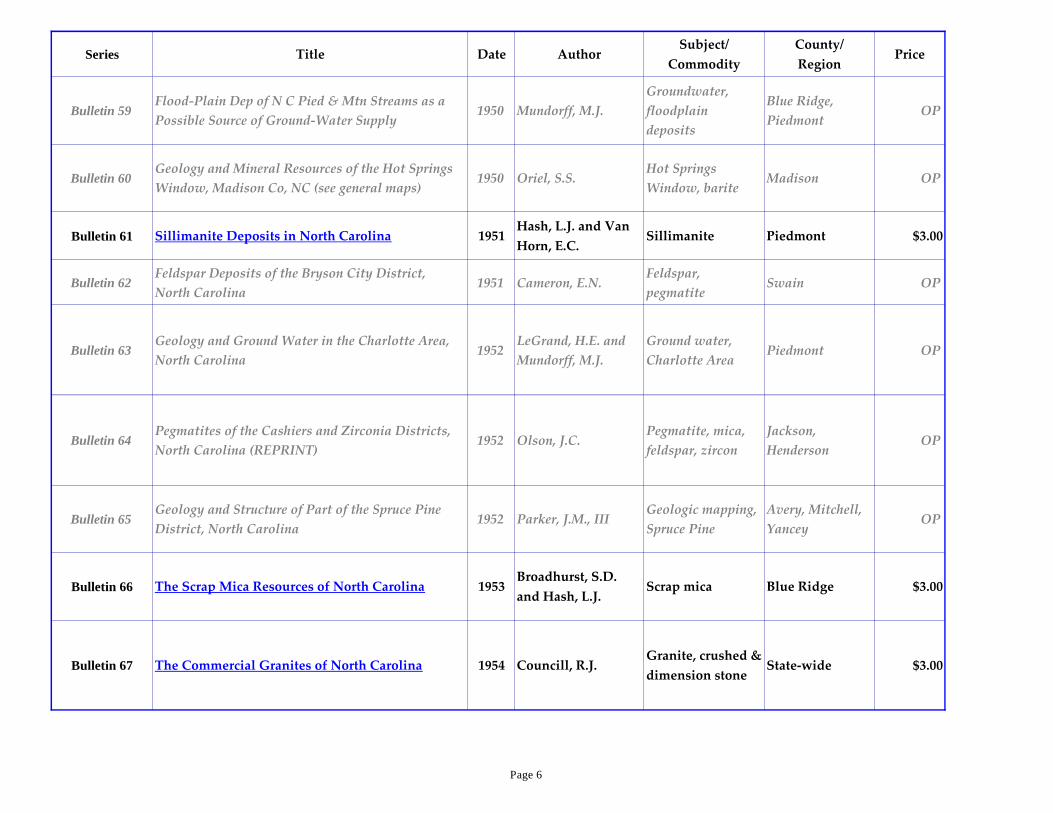
Bulletin 59Flood-Plain Dep of N C Pied & Mtn Streams as a
Possible Source of Ground-Water Supply1950 Mundorff, M.J.
Groundwater,
floodplain
deposits
Blue Ridge,
PiedmontOP
Bulletin 60Geology and Mineral Resources of the Hot Springs
Window, Madison Co, NC (see general maps)1950 Oriel, S.S.
Hot Springs
Window, bariteMadison OP
Bulletin 61 Sillimanite Deposits in North Carolina 1951Hash, L.J. and Van
Horn, E.C.Sillimanite Piedmont $3.00
Bulletin 62Feldspar Deposits of the Bryson City District,
North Carolina1951 Cameron, E.N.
Feldspar,
pegmatiteSwain OP
Bulletin 63Geology and Ground Water in the Charlotte Area,
North Carolina1952
LeGrand, H.E. and
Mundorff, M.J.
Ground water,
Charlotte AreaPiedmont OP
Bulletin 64Pegmatites of the Cashiers and Zirconia Districts,
North Carolina (REPRINT)1952 Olson, J.C.
Pegmatite, mica,
feldspar, zircon
Jackson,
HendersonOP
Bulletin 65Geology and Structure of Part of the Spruce Pine
District, North Carolina1952 Parker, J.M., III
Geologic mapping,
Spruce Pine
Avery, Mitchell,
YanceyOP
Bulletin 66 The Scrap Mica Resources of North Carolina 1953Broadhurst, S.D.
and Hash, L.J.Scrap mica Blue Ridge $3.00
Bulletin 67 The Commercial Granites of North Carolina 1954 Councill, R.J.Granite, crushed &
dimension stoneState-wide $3.00
Page 6

Series Title Date AuthorSubject/
Commodity
County/
RegionPrice
Bulletin 68Geology and Ground Water in the Statesville Area,
North Carolina1954 LeGrand, H.E.
Groundwater,
Statesville areaPiedmont OP
Bulletin 69 Ground-Water Resources in North Carolina 1954 LeGrand, H.E. Groundwater State-wide OP
Bulletin 70 Upper Cretaceous Ostracoda from North Carolina 1957 Brown, P.M.Ostracodes,
biostratigraphyCoastal Plain $3.00
Bulletin 71Explanatory Text for Geologic Map of North
Carolina (for 1958 state geologic map) 1958
Stuckey, J.L. and
Conrad S.G.Geologic mapping State-wide $3.00
Bulletin 72 Well Logs from the Coastal Plain of North Carolina 1958 Brown, P.M. Well logs Coastal Plain OP
Bulletin 73Geology and Ground Water Resources in the
Greenville Area, North Carolina1959 Brown, P.M.
Groundwater,
Greenville areaCoastal plain OP
Bulletin 74Crystalline Limestones of the Piedmont and
Mountain Regions of North Carolina1960 Conrad, S.G. Limestone
Blue Ridge,
Piedmont$4.00
Bulletin 75Geology of the Albemarle Quadrangle, North
Carolina1962 Conley, J.F. Carolina slate belt Stanly $4.00
Bulletin 76Geology and Mineral Resources of Moore County,
North Carolina w/geologic map, scale 1:62,5001962 Conley, J.F.
Carolina slate belt,
Triassic Moore $4.00
Bulletin 77 Anthophyllite asbestos in North Carolina 1963
Conrad, S.G.,
Wilson, S.F., Allen,
E.P. and Wright, T.J.
Asbestos,
ultramaficBlue Ridge $3.50
Page 7

Series Title Date AuthorSubject/
Commodity
County/
RegionPrice
Bulletin 78Cretaceous Ostracoda from wells in Southeastern
United States1964 Brown, P.M.
Ostracodes,
biostratigraphyCoastal Plain $3.50
Bulletin 79Description of the Pungo River Formation in
Beaufort County, North Carolina1965 Kimrey, J.O.
Stratigraphy,
phosphateBeaufort $4.00
Bulletin 80 Pyrophyllite Deposits in North Carolina 1967 Stuckey, J.L.Pyrophyllite,
Carolina slate beltPiedmont $3.00
Bulletin 81Geology and Mineral Resources of Orange County,
North Carolina with geologic map, scale1:62,500 1968
Allen, E.P. and
Wilson, W.F.Carolina slate belt Orange $4.00
Bulletin 82Bibliography of North Carolina Geology (see Open
File 90-2 for update)1975 Wilson, W.F. Bibliography State-wide $4.00
Bulletin 83Geological Bibliography of NC's Coastal Plain,
Coastal Zone, and Continental Shelf1975
Riggs, S.R. and
O'Connor, M.P.Bibliography Coastal Plain OP
Bulletin 84Metallic Mineral Deposits of the Carolina Slate
Belt, North Carolina1976 Carpenter, P.A, III
Gold, copper, lead,
zinc, silver
Carolina slate
beltOP
Bulletin 85Buried Oyster Shell Resource Evaluation of the
Eastern Region of the Albemarle Sound1976 Sampair, J.L. Oyster shells, lime Coast $3.00
Bulletin 86Geology and Mineral Resources of Wake Co,with
geologic map(B & W), scale 1:100,000 (REPRINT)1979 Parker, J.M., III
Raleigh belt,
Triassic sedimentsWake $10.00
Bulletin 87Stratigraphy, Structure and Phosphate Deposits of
the Pungo River Formation of NC1982 Miller, J.A.
Phosphate,
stratigraphy,
structure
Coastal Plain $4.50
Page 8
Series Title Date AuthorSubject/
Commodity
County/
RegionPrice
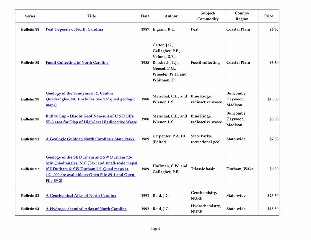
Bulletin 88 Peat Deposits of North Carolina 1987 Ingram, R.L. Peat Coastal Plain $6.50
Bulletin 89 Fossil Collecting in North Carolina 1988
Carter, J.G.,
Gallagher, P.E.,
Valone, R.E.,
Rossbach, T.J.,
Gensel, P.G.,
Wheeler, W.H. and
Whitman, D.
Fossil collecting Coastal Plain $6.50
Bulletin 90
Geology of the Sandymush & Canton
Quadrangles, NC (includes two 7.5' quad geologic
maps)
1988Merschat, C.E., and
Wiener, L.S.
Blue Ridge,
radioactive waste
Buncombe,
Haywood,
Madison
$15.00
Bulletin 90Bull 90 Sup - Disc of Geol Non-suit of U S DOE's
SE-5 area for Disp of High-level Radioactive Waste1988
Merschat, C.E., and
Wiener, L.S.
Blue Ridge,
radioactive waste
Buncombe,
Haywood,
Madison
$3.00
Bulletin 91 A Geologic Guide to North Carolina's State Parks 1989Carpenter, P.A. III
(Editor)
State Parks,
recreational geolState-wide $7.50
Bulletin 92
Geology of the SE Durham and SW Durham 7.5-
Min Quadrangles, N C (Text and small-scale maps)
(SE Durham & SW Durham 7.5' Quad maps at
1:24,000 are available as Open File-89-1 and Open
File-89-2)
1989Hoffman, C.W. and
Gallagher, P.E.Triassic basin Durham, Wake $6.50
Bulletin 93 A Geochemical Atlas of North Carolina 1991 Reid, J.C.Geochemistry,
NURE State-wide $26.50
Bulletin 94 A Hydrogeochemical Atlas of North Carolina 1993 Reid, J.C.Hydrochemistry,
NURE State-wide $15.50
Page 9
Series Title Date AuthorSubject/
Commodity
County/
RegionPrice
Bulletin 95Geology of Basement Rocks Beneath the North
Carolina Coastal Plain1993
Lawrence, D.P. and
Hoffman, C.WBasement rocks Coastal Plain $15.00
Bulletin 96Seismic Stratigraphic Framework of the Inner
Continental Shelf: Mason Inlet to New Inlet, NC1994
Snyder, S.W.
Hoffman, C.W. and
Riggs, S.R.
Seismic
StratigraphyCoastal Plain $15.00
Bulletin 97The Sims pluton, Nash and Wilson Counties,
North Carolina1997 Speer, J.A. Sims granitoid
Eastern slate
belt, Nash,
Wilson
$7.00
Bulletin 98A Geologic Adventure Along the Blue Ridge
Parkway2001
Carter, M.W.,
Merschat, C.E. and
Wilson, W.F.
Blue Ridge Mountains $10.00
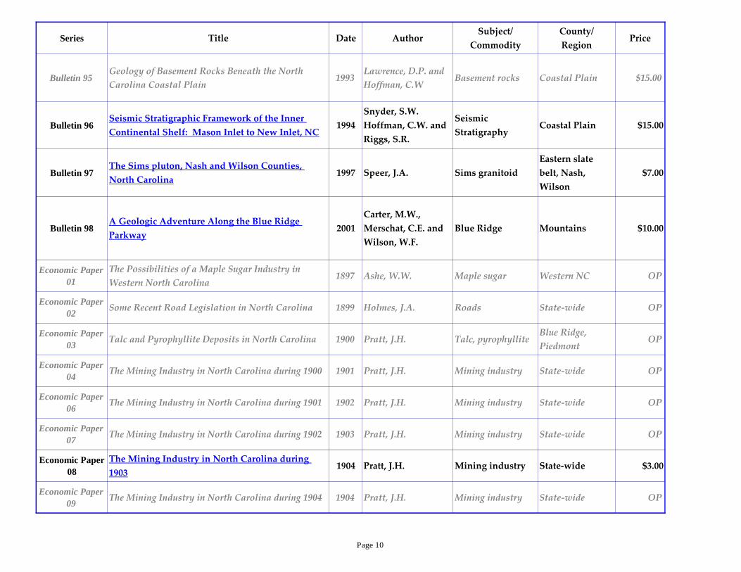
Economic Paper
01
The Possibilities of a Maple Sugar Industry in
Western North Carolina1897 Ashe, W.W. Maple sugar Western NC OP
Economic Paper
02Some Recent Road Legislation in North Carolina 1899 Holmes, J.A. Roads State-wide OP
Economic Paper
03Talc and Pyrophyllite Deposits in North Carolina 1900 Pratt, J.H. Talc, pyrophyllite
Blue Ridge,
PiedmontOP
Economic Paper
04The Mining Industry in North Carolina during 1900 1901 Pratt, J.H. Mining industry State-wide OP
Economic Paper
06The Mining Industry in North Carolina during 1901 1902 Pratt, J.H. Mining industry State-wide OP
Economic Paper
07The Mining Industry in North Carolina during 1902 1903 Pratt, J.H. Mining industry State-wide OP
Economic Paper
08
The Mining Industry in North Carolina during
19031904 Pratt, J.H. Mining industry State-wide $3.00
Economic Paper
09The Mining Industry in North Carolina during 1904 1904 Pratt, J.H. Mining industry State-wide OP
Page 10

Series Title Date AuthorSubject/
Commodity
County/
RegionPrice
Economic Paper
10Oyster Culture in North Carolina 1905 Coker, R.E. Fishing industry NC Coast OP
Economic Paper
11The Mining Industry in North Carolina during 1905 1905 Pratt, J.H. Mining industry State-wide OP
Economic Paper
12
Investigations Relative to the Shad Fisheries of
North Carolina1906 Cobb, J.N. Fishing industry NC Coast OP
Economic Paper
13
Report of Committee Appointed by Governor R.B.
Glenn to Investigate the Fishing Industries in North
Carolina
1906 Pratt, J.H. Fishing industry NC Coast OP
Economic Paper
14The Mining Industry in North Carolina during 1906 1907 Pratt, J.H. Mining industry State-wide OP
Economic Paper
15
The Mining Industry in North Carolina during 1907
with a Special Report on the Mineral Waters1908 Pratt, J.H.
Mining industry,
mineral watersState-wide OP
Economic Paper
16
Report of Convention Called by Governor R.B.
Glenn to Investigate the Fishing Industries in North
Carolina
1908 Pratt, J.H. Fishing industry State-wide OP
Economic Paper
17
Proceedings of Drainage Convention Held at
Newbern, North Carolina, September 9, 19081908 Pratt, J.H. Drainage Coastal Plain OP
Economic Paper
18
Proceedings of Second Annual Drainage Convention
Held at New Bern, North Carolina November 11
and 12, 1909
1909 Pratt, J.H. Drainage Coastal Plain OP
Economic Paper
19Forest Fires in North Carolina During 1909 1910 Holmes, J.S. Forests State-wide OP
Page 11

Series Title Date AuthorSubject/
Commodity
County/
RegionPrice
Economic Paper
20Wood-Using Industries of North Carolina 1910 Simmons, R.E. Wood State-wide OP
Economic Paper
21
Proceedings of Third Annual Drainage Convention
Held at Wilmington, North Carolina November 22
and 23, 1910
1911 Pratt, J.H. Drainage Coastal Plain OP
Economic Paper
22
Forest Fires and Their Prevention Including Forest
Fires in North Carolina During 19101911 Holmes, J.S. Forests State-wide OP
Economic Paper
23
The Mining Industry in North Carolina during
1908, 1909 and 19101911
Pratt, J.H. and Berry,
H.M.Mining industry State-wide $3.00
Economic Paper
24Fishing Industry of North Carolina 1911 Pratt, J.H. Fishing industry State-wide OP
Economic Paper
25
Proceedings of Second Annual Convention of the
North Carolina Forestry Association Held at
Raleigh, North Carolina February 21, 1912
1912 Holmes, J.S. Forests State-wide OP
Economic Paper
26
Proceedings of Fourth Annual Drainage Convention
Held at Elizabeth City, North Carolina November
15 and 16, 1911
1912 Pratt, J.H. Drainage State-wide OP
Economic Paper
27Highway Work in North Carolina 1912
Pratt, J.H. and
Berry, H.M.Highways State-wide OP
Economic Paper
28
Culverts and Small Bridges for Country Roads in
North Carolina1912
Thomas, C.R. and
Hickerson, T.F.Roads State-wide OP
Economic Paper
29
Report of the Fisheries Convention Held at New
Bern, North Carolina, December 13, 19111912 Pratt, J.H. Fishing industry NC Coast OP
Page 12
Series Title Date AuthorSubject/
Commodity
County/
RegionPrice
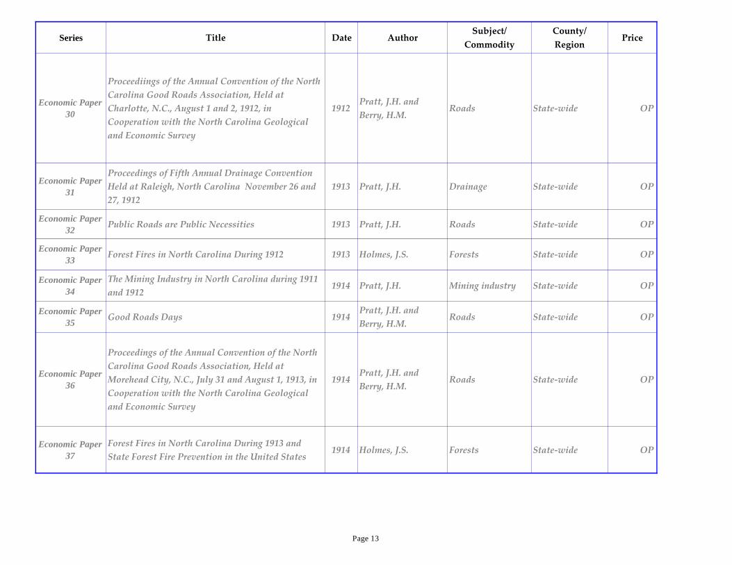
Economic Paper
30
Proceediings of the Annual Convention of the North
Carolina Good Roads Association, Held at
Charlotte, N.C., August 1 and 2, 1912, in
Cooperation with the North Carolina Geological
and Economic Survey
1912Pratt, J.H. and
Berry, H.M.Roads State-wide OP
Economic Paper
31
Proceedings of Fifth Annual Drainage Convention
Held at Raleigh, North Carolina November 26 and
27, 1912
1913 Pratt, J.H. Drainage State-wide OP
Economic Paper
32Public Roads are Public Necessities 1913 Pratt, J.H. Roads State-wide OP
Economic Paper
33Forest Fires in North Carolina During 1912 1913 Holmes, J.S. Forests State-wide OP
Economic Paper
34
The Mining Industry in North Carolina during 1911
and 19121914 Pratt, J.H. Mining industry State-wide OP
Economic Paper
35Good Roads Days 1914
Pratt, J.H. and
Berry, H.M.Roads State-wide OP
Economic Paper
36
Proceedings of the Annual Convention of the North
Carolina Good Roads Association, Held at
Morehead City, N.C., July 31 and August 1, 1913, in
Cooperation with the North Carolina Geological
and Economic Survey
1914Pratt, J.H. and
Berry, H.M.Roads State-wide OP
Economic Paper
37
Forest Fires in North Carolina During 1913 and
State Forest Fire Prevention in the United States1914 Holmes, J.S. Forests State-wide OP
Page 13

Series Title Date AuthorSubject/
Commodity
County/
RegionPrice
Economic Paper
38
Forms Covering the Organization of Drainage
Districts Under the North Carolina Drainage Law,
Chapter 442, Public Laws of 1909, and Amendments
1914 Boyd, G.R. Drainage State-wide OP
Economic Paper
39
Proceedings of the Good Roads Institute Held at the
University of North Carolina March 17-19, 19141914 Pratt, J.H. Roads State-wide OP
Economic Paper
40
Forest Fires in North Carolina During 1914 and
Forestry Laws of North Carolina1915 Holmes, J.S. Forests State-wide OP
Economic Paper
41
Proceedings of Seventh Annual Drainage
Convention of the North Carolina Drainage
Association Held at Wilson, North Carolina
November 18 and 19, 1914
1915Pratt, J.H. and
Berry, H.M.Drainage State-wide OP
Economic Paper
42
Organization of Co-Operative Forest-Fire
Protective Areas in North Carolina1915 Holmes, J.S. Forests State-wide OP
Economic Paper
43
Proceedings of the Second Good Roads Institute
Held at the University of North Carolina February
23-27, 1915
1916Pratt, J.H. and
Berry, H.M.Roads State-wide OP
Economic Paper
44
Highway Work in North Carolina During the
Calendar Year Ending December 31, 19141917
Pratt, J.H. and
Berry, H.M.Highways State-wide OP
Economic Paper
45
Proceedings of the Eighth Annual Drainage
Convention of the North Carolina Drainage
Association Held at Belhaven, North Carolina,
November 29, 30 and December 1, 1915
1917Pratt, J.H. and
Berry, H.M.Drainage State-wide OP
Page 14

Series Title Date AuthorSubject/
Commodity
County/
RegionPrice
Economic Paper
46The Vegetation of Shackleford Bank 1917 Lewis, I.F. Vegetation Carteret OP
Economic Paper
47
Proceedings of the Ninth Annual Drainage
Convention of the North Carolina Drainage
Association Held at Greensboro, North Carolina,
November 22 and 23, 1916
1917Pratt, J.H. and
Berry, H.M.Drainage State-wide OP
Economic Paper
48
Forest Fires in North Carolina During 1915, 1916
and 19171918 Holmes, J.S. Forests State-wide OP
Economic Paper
49
The Mining Industry in North Carolina during
1913 to 1917, inclusive1919
Pratt, J.H. and Berry,
H.M.Mining industry State-wide $3.00
Economic Paper
50
Proceedings of the Tenth Annual Drainage
Convention Held at Washington, North Carolina,
March 31 and April 1, 1920
1920
North Carolina
Geological and
Economic Survey
Drainage State-wide OP
Economic Paper
51
Forest Fires in North Carolina During 1918, 1919,
and 19201921 Holmes, J.S. Forests State-wide OP
Economic Paper
52
Proceedings of the Eleventh Annual Drainage
Convention Held at Elizabeth City, North Carolina
April 12 and 13, 1921
1921
North Carolina
Geological and
Economic Survey
Drainage State-wide OP
Economic Paper
53Water Power Survey of Surry and Wilkes Counties 1922 Saville, T. Water Surry, Wilkes OP
Economic Paper
54Water-Power Investigation of Deep River 1924 Saville, T. Water Piedmont OP
Page 15

Series Title Date AuthorSubject/
Commodity
County/
RegionPrice
Economic Paper
55
The Mineral Industry in North Carolina, 1918 to
1923, inclusive1925
Drane, B.S. and
Stuckey, J.L.Mining industry State-wide $3.00
Economic Paper
56Chestnut and the Chestnut Blight in North Carolina 1925
Buttrick, P.L.,
Frothingham, E.H.,
Gravatt, G.F. and
Bruner, E.M.
Trees Mountains OP
Economic Paper
57
The Economic Development of the Furniture
Industry of the South and its Future Dependence
Upon Forestry
1926 Korstian, C.F. Forests State-wide OP
Economic Paper
58
Oil Prospecting Well Near Havelock, North
Carolina1927 Mansfield, W.C. Oil test well Craven OP
Economic Paper
59Oil-Bearing Shales of Deep River Valley 1927 Vilbrandt, F.C.
Oil shale, Deep
River Valley
Chatham, Lee,
Moore$3.00
Economic Paper
60
The Mineral Industry in North Carolina for 1924
and 19251927 Bryson, H.J. Mineral Industry State-wide OP
Economic Paper
61
Preliminary Report on the Chemical Quality of the
Surface Waters of North Carolina With Relation to
Industrial Use
Ray, C.E., Jr. and
Randolph, E.E.Water State-wide OP
Economic Paper
62The Mineral Industry in North Carolina during 1926 1928 Bryson, H.J. Mining industry State-wide OP
Economic Paper
63
The Mining Industry in North Carolina during
1927 and 19281930 Bryson, H.J. Mining industry State-wide $3.00
Economic Paper
64
The Mining Industry in North Carolina during 1929
to 19361937 Bryson, H.J. Mining industry State-wide OP
Economic Paper
65
The Mining Industry in North Carolina from 1937
to 19451950 Murdock, T.G. Mining industry State-wide $3.00
Page 16

Series Title Date AuthorSubject/
Commodity
County/
RegionPrice
Economic Paper
66
The Mining Industry in North Carolina from 1946
through 19531955 Broadhurst, S.D. Mining industry State-wide $3.00
Economic Paper
67
Mineral Industry of North Carolina from 1954
through 19591961
Stuckey, J.L. and
Conrad, S.G.Mining industry State-wide $3.00
Economic Paper
68
Mineral Industry of North Carolina from 1960
through 19671970 Stuckey, J.L. Mining industry State-wide $3.00
Educational
Series 1The Story of the Geologic Making of North Carolina 1928 Bryson, H.J. General geology State-wide OP
Educational
Series 2
An Introduction to the Topography, Geology and
Mineral Resources of North Carolina1952
Broadhurst, S.D.
(rev 1975)General geology State-wide OP
Educational
Series 3Geology and Mineral Resources of North Carolina 1953
Stuckey, J.L. and
Steel, W.G.General geology State-wide OP
Educational
Series 4
North Carolina Geology and Mineral Resources: A
Foundation for Progress1976
Wilson, W.F.,
Carpenter, P.A., III
and Conrad, S.G.
General geology State-wide OP
FTG AASG-75
Field Guidebook to the Geology of the Central Blue
Ridge of North Carolina and the Spruce Pine
Mining District
1975Wiener, L.S. and
Merschat, C.E.
Field trip
guidebookBlue Ridge OP
FTG AASG-90Guidebook to the Geology of the central Blue Ridge
of NC and the Spruce Pine Mining District1990
Wiener, L.S. and
Merschat, C.E.
Field trip
guidebookBlue Ridge OP
FTG ACPGA-63 The Geology of Northeastern North Carolina 1963 Brown, P.M.Field trip
guidebook
Northeastern &
central Coastal
Plain
OP
Page 17

Series Title Date AuthorSubject/
Commodity
County/
RegionPrice
FTG CGS 2002
Inner Piedmont Geology in the South Mountains-
Blue Ridge Foothills and the southwestern Brushy
Mountains, central-western North Carolina
2002Hatcher, R.D., Jr., &
Bream, B.R.
Field trip
guidebookInner Piedmont OP
FTG CGS 2003
Surficial Geology and Shallow Aquifer System of
the Little Contentnea Creek Watershed, Neuse River
Basin, North Carolina
2003Farrell, K.M. and
Keyworth, A.J.
Field trip
guidebookEastern NC OP
FTG CGS 2005
Blue Ridge Geology Geotraverse East of the Great
Smoky Mountains National Park, Western North
Carolina
2005Hatcher, R.D. Jr.
and Merschat, A.J.
Field trip
guidebookBlue Ridge OP
FTG CGS 2006
The Geology of the Chapel Hill, Hillsborough and
Efland 75-minute Quadrangles, Orange and
Durham Counties, Carolina Terrane, North
Carolina
2006
Bradley, P.J.,
Wooten, R.M.,
Latham, R. & Gay,
N.K.
Field trip
guidebook
Orange &
DurhamOP
FTG CGS-55Guidebook of Excursion in the Coastal Plain of
North Carolina, October 8-9, 19551955
LeGrand, H.E. and
Brown, P.M.
Field trip
guidebookCoastal Plain OP
FTG CGS-59Geology of the Albemarle and Denton Quadrangles,
North Carolina1959
Stromquist, A.A.
and Conley, J.F.
Field trip
guidebookDavidson, Stanly OP
FTG CGS-60Road Log of the Grandfather Mountain Area, North
Carolina1960
Bryant, B. and Reed,
J.C., Jr.
Field trip
guidebookBlue Ridge OP
FTG CGS-62Road Log of the Geology of Moore County, North
Carolina1962 Conley, J.F.
Field trip
guidebookMoore $3.00
FTG CGS-64Road Log of the Chatham, Randolph and Orange
County Areas, North Carolina1964 Bain, G.L.
Field trip
guidebook
Chatham,
Orange,
Randolph
$3.00
Page 18
Series Title Date AuthorSubject/
Commodity
County/
RegionPrice
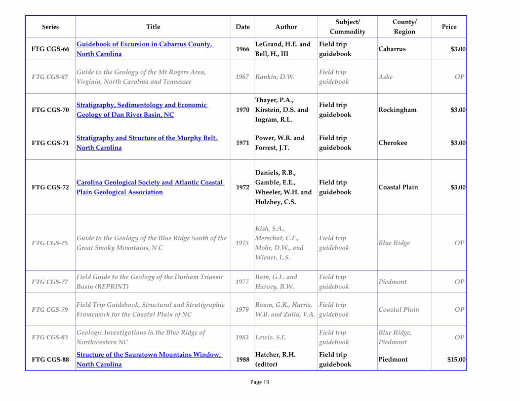
FTG CGS-66Guidebook of Excursion in Cabarrus County,
North Carolina1966
LeGrand, H.E. and
Bell, H., III
Field trip
guidebookCabarrus $3.00
FTG CGS-67Guide to the Geology of the Mt Rogers Area,
Virginia, North Carolina and Tennessee1967 Rankin, D.W.
Field trip
guidebookAshe OP
FTG CGS-70Stratigraphy, Sedimentology and Economic
Geology of Dan River Basin, NC1970
Thayer, P.A.,
Kirstein, D.S. and
Ingram, R.L.
Field trip
guidebookRockingham $3.00
FTG CGS-71Stratigraphy and Structure of the Murphy Belt,
North Carolina1971
Power, W.R. and
Forrest, J.T.
Field trip
guidebookCherokee $3.00
FTG CGS-72Carolina Geological Society and Atlantic Coastal
Plain Geological Association1972
Daniels, R.B.,
Gamble, E.E.,
Wheeler, W.H. and
Holzhey, C.S.
Field trip
guidebookCoastal Plain $3.00
FTG CGS-75Guide to the Geology of the Blue Ridge South of the
Great Smoky Mountains, N C1975
Kish, S.A.,
Merschat, C.E.,
Mohr, D.W., and
Wiener, L.S.
Field trip
guidebookBlue Ridge OP
FTG CGS-77Field Guide to the Geology of the Durham Triassic
Basin (REPRINT)1977
Bain, G.L. and
Harvey, B.W.
Field trip
guidebookPiedmont OP
FTG CGS-79Field Trip Guidebook, Structural and Stratigraphic
Framework for the Coastal Plain of NC1979
Baum, G.R., Harris,
W.B. and Zullo, V.A.
Field trip
guidebookCoastal Plain OP
FTG CGS-83Geologic Investigations in the Blue Ridge of
Northwestern NC1983 Lewis. S.E.
Field trip
guidebook
Blue Ridge,
PiedmontOP
FTG CGS-88Structure of the Sauratown Mountains Window,
North Carolina1988
Hatcher, R.H.
(editor)
Field trip
guidebookPiedmont $15.00
Page 19
Series Title Date AuthorSubject/
Commodity
County/
RegionPrice
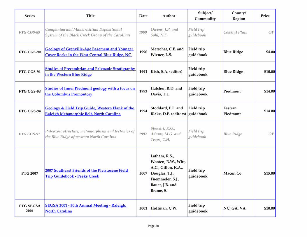
FTG CGS-89Campanian and Maastrichtian Depositional
System of the Black Creek Group of the Carolinas1989
Owens, J.P. and
Sohl, N.F.
Field trip
guidebookCoastal Plain OP
FTG CGS-90Geology of Grenville-Age Basement and Younger
Cover Rocks in the West Central Blue Ridge, NC 1990
Merschat, C.E. and
Wiener, L.S.
Field trip
guidebookBlue Ridge $4.00
FTG CGS-91Studies of Precambrian and Paleozoic Stratigraphy
in the Western Blue Ridge1991 Kish, S.A. (editor)
Field trip
guidebookBlue Ridge $10.00
FTG CGS-93Studies of Inner Piedmont geology with a focus on
the Columbus Promontory1993
Hatcher, R.D. and
Davis, T.L.
Field trip
guidebookPiedmont $14.00
FTG CGS-94Geology & Field Trip Guide, Western Flank of the
Raleigh Metamorphic Belt, North Carolina1994
Stoddard, E.F. and
Blake, D.E. (editors)
Field trip
guidebook
Eastern
Piedmont$14.00
FTG CGS-97Paleozoic structure, metamorphism and tectonics of
the Blue Ridge of western North Carolina1997
Stewart, K.G.,
Adams, M.G. and
Trupe, C.H.
Field trip
guidebookBlue Ridge OP
FTG 20072007 Southeast Friends of the Pleistocene Field
Trip Guidebook - Peeks Creek2007
Latham, R.S.,
Wooten, R.W., Witt,
A.C., Gillon, K.A.,
Douglas, T.J.,
Fuemmeler, S.J.,
Bauer, J.B. and
Brame, S.
Field trip
guidebookMacon Co $15.00
FTG SEGSA
2001
SEGSA 2001 - 50th Annual Meeting - Raleigh,
North Carolina2001 Hoffman, C.W.
Field trip
guidebookNC, GA, VA $10.00
Page 20

Series Title Date AuthorSubject/
Commodity
County/
RegionPrice
FTG SEGSA
2011
Natural Gas Potential of the Sanford sub-basin,
Deep River Basin, North Carolina2011
Reid, J.C., Taylor,
K.B., Olsen, P.E. and
Patterson, III, O.F.
Field trip
guidebook
Lee, Chatham,
Moore
FTG SEGSA-55Piedmont Field Trip, April 9, Southeastern Section
Geological Society of America1955
Stuckey, J.L.,
Parker, J.M., III,
Mann, V.I. and
Broadhurst, S.D.
Field trip
guidebookPiedmont $3.00
FTG SEGSA-59Guidebook for Piedmont Field Trip, Featuring
Metamorphic Facies in the Raleigh Area, NC1959
Parker, J.M., III, and
Broadhurst, S.D.
Field trip
guidebookWake $3.00
FTG SEGSA-77Field Guides for the GSA, Southeastern Section
Meeting, Winston-Salem, NC1977 Burt, E.R. (editor)
Field trip
guidebookPiedmont $5.00
FTG SEGSA-92
Geologic Field Guides to North Carolina and
Vicinity (Thirteen field trip guides for SE GSA
Meeting)
1992
Dennison, J.M. and
Stewart, K.G.
(editor)
Field trip
guidebookState-wide $20.00
FTG TRIBITRIBI: Triassic Basin Initiative Workshop and
field trip in the Deep River Triassic basin, NC1997 Clark, T.W. (editor)
Field trip
guidebook
Deep River
Triassic basinOP
Geologic Notes 1Earth Science Resource Guide for Teachers as of July
19941994
Watson, M.E. and
BumgarnerResource Guide State-wide OP
Page 21

Series Title Date AuthorSubject/
Commodity
County/
RegionPrice
Geologic Notes 2
Investigating the Miocene Geology of the NC
Continental Shelf Exercises for Grades 9-12
(designed to accompany Geologic Map Series #3:
Miocene Geology of the Continental Shelf, page 7)
1994
Louden, C.K.,
Stanfill, J.B. and
Watson, M.E.
Miocene
Educational
Exercises
Continental
ShelfOP
Geologic Notes 3Materials from the Earth- Rock & Mineral Products
from the Asheville-Buncombe Co Area1995 NCGS Mineral Resources Buncombe Co Free
Geologic Notes 4 A Listing of North Carolina Minerals 1995Wiener, L. and
Ballew, S.Minerals State-wide Free
Geologic Notes 5 Geology of Yancey County 1997 Merschat, C.E.Geologic Map and
textYancey Co Free
Geologic Notes 6Educational Resources Available from the North
Carolina Geological Survey1998 Watson, M.
Educational
resourcesState-wide Free
Geologic Notes 7Map of earthquake epicenters in North Carolina and
portions of adjacent states (1698-1997)1998
Axon, A.G. and
Wooten, R.M.Earthquake map State-wide Free
Geologic Notes
8
Mineralogy and History of the Ray Mica mine,
Yancey County, North Carolina2004
Miller, J.W. and
Allen, C.W.Mica Yancey Co OP
Geologic Notes
10
Generalized Bedrock Geologic Map of Wake
County, North Carolina2008
Bechtel, R., Medina,
M.A. and Nickerson,
J.G.
Geologic map Wake Co Free
Page 22
Series Title Date AuthorSubject/
Commodity
County/
RegionPrice
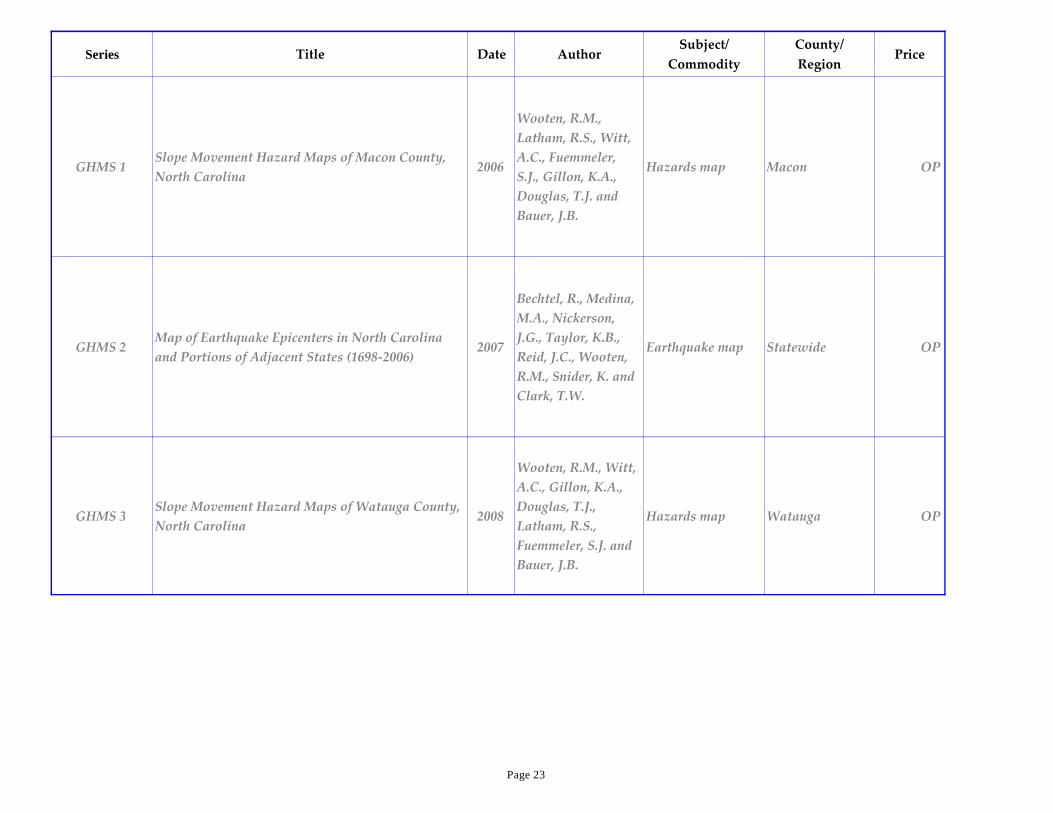
GHMS 1Slope Movement Hazard Maps of Macon County,
North Carolina2006
Wooten, R.M.,
Latham, R.S., Witt,
A.C., Fuemmeler,
S.J., Gillon, K.A.,
Douglas, T.J. and
Bauer, J.B.
Hazards map Macon OP
GHMS 2Map of Earthquake Epicenters in North Carolina
and Portions of Adjacent States (1698-2006)2007
Bechtel, R., Medina,
M.A., Nickerson,
J.G., Taylor, K.B.,
Reid, J.C., Wooten,
R.M., Snider, K. and
Clark, T.W.
Earthquake map Statewide OP
GHMS 3Slope Movement Hazard Maps of Watauga County,
North Carolina2008
Wooten, R.M., Witt,
A.C., Gillon, K.A.,
Douglas, T.J.,
Latham, R.S.,
Fuemmeler, S.J. and
Bauer, J.B.
Hazards map Watauga OP
Page 23

Series Title Date AuthorSubject/
Commodity
County/
RegionPrice
GHMS 4 Buncombe County Landslide Hazards Maps 2009
Wooten, R.M., Witt,
A.C., Gillon, K.A.,
Douglas, T.J.,
Fuemmeler, S.J.,
Bauer, J.B. and
Latham, R.S.
Hazards map Buncombe OP
GMS 1Geology of the PILOT MOUNTAIN and
PINNACLE Quadrangles, North Carolina1969
Dunn, D.E., and
Wiegand, P.W.Geologic map Stokes, Surry $3.00
GMS 2Geology of the WINSTEAD 15-minute
Quadrangle, North Carolina 1975 Wilson, W.F. Geologic map Caswell, Person $3.00
GMS 3Miocene Geology of the Continental Shelf:
Onslow Bay, North Carolina1993
Snyder, S.W., Hine,
A.C., Riggs, S.R. and
Snyder, S.W.
Miocene Geology Onslow Bay $4.00
GMS 4Simple Bouguer Gravity Anomaly Map, Raleigh 30
X 60-Minute quadrangle1996 Lawrence, D.P.
Gravity map,
Geophysics
E Pied, Inner
Coast Pl$3.00
GMS 5Aeromagnetic Map of the Raleigh 30 X 60-minute
Quadrangle (1:100,000)1996
Carpenter, R.H.,
compiler
Aeromagnetic
map, Geophysics
E Pied, Inner
Coast Pl$3.00
GMS 6Geologic Map and Mineral Resources Summary of
the TOPTON Quadrangle, NC1998
Ausburn, M.P.,
Hatcher, R.D., Jr.,
Bryan, J.G.,
Godfrey, S.C. and
Acker, L.A.
Geologic map
Macon,
Cherokee, Clay,
Graham
$4.00
Page 24

Series Title Date AuthorSubject/
Commodity
County/
RegionPrice
GMS 7 America's First State Geologic Map 1999 Clark, T.W. Historic geology State-wide $4.00
GMS 8Bedrock Geologic Map and Mineral Resources
Summary of the FINES CREEK Quad, NC1999
Carter, M.W., and
Wiener, L.S.Geologic map
Haywood,
Madison,
Buncombe
$4.25
GMS 9
Bedrock Geologic Map of the Bent Creek Research
and Demonstration Forest, Southern Research
Station, USDA Forest Service, Including the North
Carolina Arboretum and a Portion of the Blue
Ridge Parkway
2002Merschat, C.E., and
Carter, M.W.Geologic map Buncombe $11.00
GMS 10ABedrock Geologic Map of Gorges State Park,
Transylvania County, NC2003
Merschat, C.E., and
Carter, M.W., and
Wooten, R.M.
Geologic map Transylvania $11.00
GMS 10B
Map of Slope Movements and Related Surficial
Deposits Gorges State Park, Transylvania County,
NC
2003
Wooten, R.M.,
Merschat, C.E. and
Carter, M.W.
Slope movements Transylvania $11.00
GMS 11Bedrock Geologic Map of the LEMON GAP
Quadrangle, NC & TN2007
Merschat, C.E.,
Cattanach, B.L., and
Carter, M.W.
Geologic mapMadison,
Haywood$11.00
GMS 12Bedrock Geologic Map of the SPRING CREEK
Quadrangle, NC & TN2007
Cattanach, B.L,,
Merschat, C.E., and
Carter, M.W.
Geologic map Madison $11.00
Page 25
Series Title Date AuthorSubject/
Commodity
County/
RegionPrice
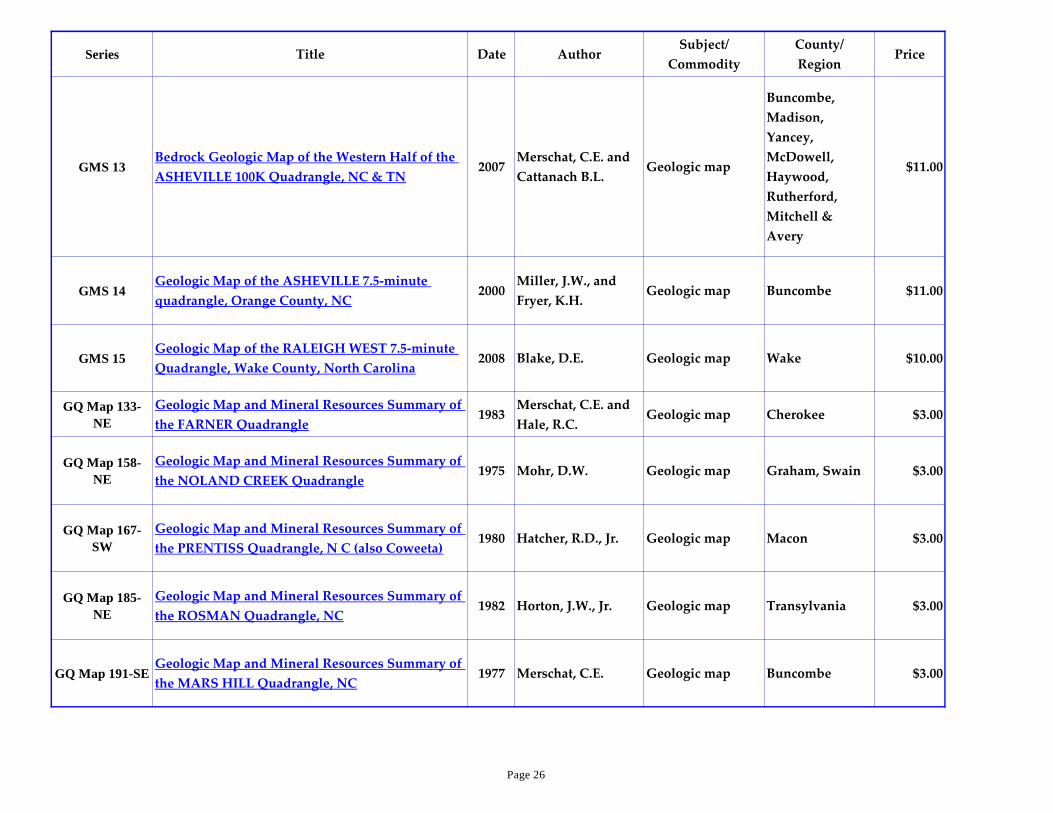
GMS 13Bedrock Geologic Map of the Western Half of the
ASHEVILLE 100K Quadrangle, NC & TN2007
Merschat, C.E. and
Cattanach B.L.Geologic map
Buncombe,
Madison,
Yancey,
McDowell,
Haywood,
Rutherford,
Mitchell &
Avery
$11.00
GMS 14Geologic Map of the ASHEVILLE 7.5-minute
quadrangle, Orange County, NC2000
Miller, J.W., and
Fryer, K.H.Geologic map Buncombe $11.00
GMS 15Geologic Map of the RALEIGH WEST 7.5-minute
Quadrangle, Wake County, North Carolina2008 Blake, D.E. Geologic map Wake $10.00
GQ Map 133-
NE
Geologic Map and Mineral Resources Summary of
the FARNER Quadrangle1983
Merschat, C.E. and
Hale, R.C.Geologic map Cherokee $3.00
GQ Map 158-
NE
Geologic Map and Mineral Resources Summary of
the NOLAND CREEK Quadrangle1975 Mohr, D.W. Geologic map Graham, Swain $3.00
GQ Map 167-
SW
Geologic Map and Mineral Resources Summary of
the PRENTISS Quadrangle, N C (also Coweeta)1980 Hatcher, R.D., Jr. Geologic map Macon $3.00
GQ Map 185-
NE
Geologic Map and Mineral Resources Summary of
the ROSMAN Quadrangle, NC1982 Horton, J.W., Jr. Geologic map Transylvania $3.00
GQ Map 191-SEGeologic Map and Mineral Resources Summary of
the MARS HILL Quadrangle, NC1977 Merschat, C.E. Geologic map Buncombe $3.00
Page 26
Series Title Date AuthorSubject/
Commodity
County/
RegionPrice
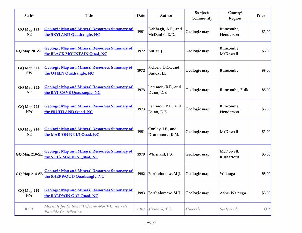
GQ Map 193-
NE
Geologic Map and Mineral Resources Summary of
the SKYLAND Quadrangle, NC1981
Dabbagh, A.E., and
McDaniel, R.D.Geologic map
Buncombe,
Henderson$3.00
GQ Map 201-SEGeologic Map and Mineral Resources Summary of
the BLACK MOUNTAIN Quad, NC1972 Butler, J.R. Geologic map
Buncombe,
McDowell$3.00
GQ Map 201-
SW
Geologic Map and Mineral Resources Summary of
the OTEEN Quadrangle, NC1972
Nelson, D.O., and
Bundy, J.L.Geologic map Buncombe $3.00
GQ Map 202-
NE
Geologic Map and Mineral Resources Summary of
the BAT CAVE Quadrangle, NC1973
Lemmon, R.E., and
Dunn, D.E.Geologic map Buncombe, Polk $3.00
GQ Map 202-
NW
Geologic Map and Mineral Resources Summary of
the FRUITLAND Quad, NC1973
Lemmon, R.E., and
Dunn, D.E.Geologic map
Buncombe,
Henderson$3.00
GQ Map 210-
NE
Geologic Map and Mineral Resources Summary of
the MARION NE 1/4 Quad, NC1981
Conley, J.F., and
Drummond, K.M.Geologic map McDowell $3.00
GQ Map 210-SEGeologic Map and Mineral Resources Summary of
the SE 1/4 MARION Quad, NC1979 Whisnant, J.S. Geologic map
McDowell,
Rutherford$3.00
GQ Map 214-SEGeologic Map and Mineral Resources Summary of
the SHERWOOD Quadrangle, NC1982 Bartholomew, M.J. Geologic map Watauga $3.00
GQ Map 220-
NW
Geologic Map and Mineral Resources Summary of
the BALDWIN GAP Quad, NC1983 Bartholomew, M.J. Geologic map Ashe, Watauga $3.00
IC 01Minerals for National Defense--North Carolina's
Possible Contribution1940 Murdock, T.G. Minerals State-wide OP
Page 27

Series Title Date AuthorSubject/
Commodity
County/
RegionPrice
IC 02 Production of Mica in North Carolina 1942 Murdock, T.G. Mica Blue Ridge OP
IC 03Selected Well Logs in the Coastal Plain of North
Carolina1944 Mundorff, M.J. Well logs Coastal Plain OP
IC 04 Occurrence of Sillimanite in North Carolina 1946Hunter, C.E. and
White, W.A.Sillimanite
Blue Ridge,
PiedmontOP
IC 05The Geology and Mineral Resources of Guilford
County1947 Murdock, T.G. General geology Guilford $3.00
IC 06A Possible Source of Ground-Water Supply in the
Elizabeth City Area, NC1947 Mundorff, M.J.
Groundwater,
Elizabeth CityCoastal Plain OP
IC 07A General Survey of Some High Silica Materials in
North Carolina1950 Broadhurst, S.D.
High-silica
materialsState-wide $3.00
IC 08White Residual Clays of the Volcanic Slate Belt in
North Carolina1950 Broadhurst, S.D.
Residual clays,
slate beltPiedmont OP
IC 09The Eastern Piedmont Pegmatite District of North
Carolina1952 Steel, W.G.
Feldspar, mica,
pegmatitePiedmont OP
IC 10High-Alumina Minerals in the Volcanic Slate Series
of North Carolina1953
Broadhurst, S.D.
and Councill, R.J.
Kyanite,
pyrophyllitePiedmont OP
IC 11 High-Silica Sand Resources of North Carolina 1954 Broadhurst, S.D. High-silica sand Coastal Plain $3.00
IC 12 Commercial Rocks of the Carolina Slate Belt 1954 Councill, R.J.Building stone,
crushed stone
Piedmont,
Carolina slate
belt
$3.00
Page 28

Series Title Date AuthorSubject/
Commodity
County/
RegionPrice
IC 13Petrography and Economic Aspects of the Misc
Commercial Rocks of NC1955 Councill, R.J.
Building stone,
crushed stone
Blue Ridge,
Piedmont$3.00
IC 14An Introduction to Radioactive Minerals in North
Carolina1955 Councill, R.J.
Radioactive
mineralsState-wide OP
IC 15 Lithium Resources of North Carolina 1956 Broadhurst, S.D. Lithium State-wide $3.00
IC 16 Mineral Localities of North Carolina 1958 Conley, J.F.Mineral collecting,
gem stonesState-wide OP
IC 17 Beryl Occurrences in North Carolina 1962 Wilson, W.F. Beryl, berylliumBlue Ridge,
PiedmontOP
IC 18The Force of Gravity at Selected Localities in
North Carolina1963 Mann, V.I. Gravity State-wide $3.00
IC 19 Titanium Deposits in North Carolina 1964 Williams, L. Titanium State-wide $3.00
IC 20 The Feldspar Resources of North Carolina 1969Bundy, J.L. and
Carpenter, P.A., IIIFeldspar Blue Ridge $3.00
IC 21 Gold Resources of North Carolina 1972 Carpenter, P.A., III Gold State-wide OP
IC 22 Exploratory Oil Wells of North Carolina 1925-1976 1977Coffey, J.C.,
compilerOil wells Coastal Plain $3.00
IC 23Diabase Dikes of the Eastern Piedmont of North
Carolina1978
Burt, E.R.,
Carpenter, P.A., III,
McDaniel, R.D. and
Wilson, W.F.
Diabase dikes Piedmont $3.00
Page 29
Series Title Date AuthorSubject/
Commodity
County/
RegionPrice
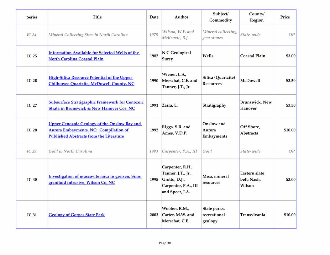
IC 24 Mineral Collecting Sites in North Carolina 1978Wilson, W.F. and
McKenzie, B.J.
Mineral collecting,
gem stonesState-wide OP
IC 25Information Available for Selected Wells of the
North Carolina Coastal Plain1982
N C Geological
SureyWells Coastal Plain $3.00
IC 26High-Silica Resource Potential of the Upper
Chilhowee Quartzite, McDowell County, NC1990
Wiener, L.S.,
Merschat, C.E. and
Tanner, J.T., Jr.
Silica (Quartzite)
ResourcesMcDowell $3.50
IC 27Subsurface Stratigraphic Framework for Cenozoic
Strata in Brunswick & New Hanover Cos, NC1991 Zarra, L. Stratigraphy
Brunswick, New
Hanover$3.50
IC 28
Upper Cenozoic Geology of the Onslow Bay and
Aurora Embayments, NC: Compilation of
Published Abstracts from the Literature
1992Riggs, S.R. and
Ames, V.D.P.
Onslow and
Aurora
Embayments
Off Shore,
Abstracts$10.00
IC 29 Gold in North Carolina 1993 Carpenter, P.A., III Gold State-wide OP
IC 30Investigation of muscovite mica in greisen, Sims
granitoid intrusive, Wilson Co, NC1995
Carpenter, R.H.,
Tanner, J.T., Jr.,
Grotto, D.J.,
Carpenter, P.A., III
and Speer, J.A.
Mica, mineral
resources
Eastern slate
belt; Nash,
Wilson
$3.00
IC 31 Geology of Gorges State Park 2003
Wooten, R.M.,
Carter, M.W. and
Merschat, C.E.
State parks,
recreational
geology
Transylvania $10.00
Page 30
Series Title Date AuthorSubject/
Commodity
County/
RegionPrice
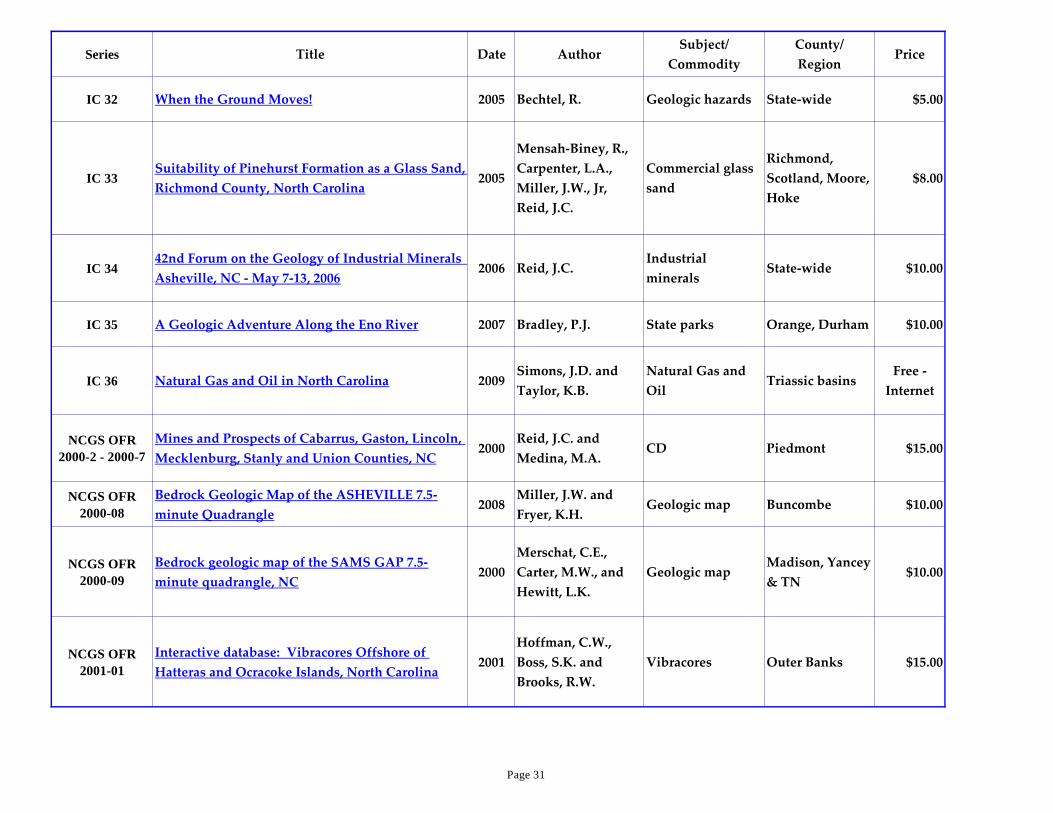
IC 32 When the Ground Moves! 2005 Bechtel, R. Geologic hazards State-wide $5.00
IC 33Suitability of Pinehurst Formation as a Glass Sand,
Richmond County, North Carolina2005
Mensah-Biney, R.,
Carpenter, L.A.,
Miller, J.W., Jr,
Reid, J.C.
Commercial glass
sand
Richmond,
Scotland, Moore,
Hoke
$8.00
IC 3442nd Forum on the Geology of Industrial Minerals
Asheville, NC - May 7-13, 20062006 Reid, J.C.
Industrial
mineralsState-wide $10.00
IC 35 A Geologic Adventure Along the Eno River 2007 Bradley, P.J. State parks Orange, Durham $10.00
IC 36 Natural Gas and Oil in North Carolina 2009Simons, J.D. and
Taylor, K.B.
Natural Gas and
OilTriassic basins
Free -
Internet
NCGS OFR
2000-2 - 2000-7
Mines and Prospects of Cabarrus, Gaston, Lincoln,
Mecklenburg, Stanly and Union Counties, NC2000
Reid, J.C. and
Medina, M.A.CD Piedmont $15.00
NCGS OFR
2000-08
Bedrock Geologic Map of the ASHEVILLE 7.5-
minute Quadrangle2008
Miller, J.W. and
Fryer, K.H.Geologic map Buncombe $10.00
NCGS OFR
2000-09
Bedrock geologic map of the SAMS GAP 7.5-
minute quadrangle, NC2000
Merschat, C.E.,
Carter, M.W., and
Hewitt, L.K.
Geologic mapMadison, Yancey
& TN$10.00
NCGS OFR
2001-01
Interactive database: Vibracores Offshore of
Hatteras and Ocracoke Islands, North Carolina2001
Hoffman, C.W.,
Boss, S.K. and
Brooks, R.W.
Vibracores Outer Banks $15.00
Page 31

Series Title Date AuthorSubject/
Commodity
County/
RegionPrice
NCGS OFR
2001-02
Interactive database: Vibracores from Offshore
Northern Dare County, North Carolina2001
Hoffman, C.W. and
Brooks, R.W.Vibracores Dare County $15.00
NCGS OFR
2001-04
Bedrock geologic map of the WHITE ROCK 7.5-
minute quadrangle, NC2001
Carter, M.W.,
Williams, S.T. and
Merschat, C.E.
Geologic map Madison County $10.00
NCGS OFR
2002-01
Bedrock Geologic Map of the Southeast Portion of
the OXFORD 7.5-minute Quadrangle, Granville
and Vance Counties, North Carolina
2002
Wooten, R.M.,
Blake, D.E.,
Phillips, C.M., and
Farris, P.F.
Geologic mapGranville and
Vance$8.00
NCGS OFR
2004-01
Geologic map of the CHAPEL HILL 7.5-minute
quadrangle, Orange and Durham Counties, NC2004
Bradley, P.J.,
Phillips, C., Gay,
N.K., and
Fuemmeler, S.J.
Geologic mapOrange &
Durham$10.00
NCGS OFR
2004-02
Preliminary bedrock geologic map of the
RALEIGH 30"x60" quadrangle, NC2004
Clark, T.W., Blake,
D.E., Stoddard, E.F. ,
Carpenter, P.A., III,
Carpenter, R.H.
Geologic map
Wake, Johnston,
Nash, Durham,
Franklin,
Chatham,
Wilson, Harnett
& Wayne
$10.00
NCGS OFR
2004-03a
Geologic Map of NORTHWEST DURHAM 7.5-
minute Quadrangles Durham and Orange
Counties, North Carolina
2004
Bradley, P.J.,
Phillips, C.M.,
Bechtel, R.,
Witanachchi, C.,
Ward, A.N., and
Clark, T.W.
Geologic mapDurham and
Orange$10.00
Page 32

Series Title Date AuthorSubject/
Commodity
County/
RegionPrice
NCGS OFR
2004-03b
Geologic Map of NORTHEAST DURHAM 7.5-
minute Quadrangles Durham, Granville and
Wake Counties, North Carolina
2004
Phillips, C.M.,
Witanachchi, C.,
Ward, A.N., and
Clark, T.W.
Geologic map
Durham,
Granville and
Wake
$10.00
NCGS OFR
2004-04
Bedrock geologic map of the PAINT ROCK 7.5-
minute quadrangle, NC & TN2004
Merschat, C.E., and
Cattanach, B.L.Geologic map
Madison Co, NC
& TN$10.00
NCGS OFR
2005-01
New Digital Raster Graphics of North Carolina:
1999 - 20052005
Reid, J.C. and
Medina, M.A.DRG's Statewide $15.00
NCGS OFR
2005-02
Geologic map of the HILLSBOROUGH 7.5-minute
quadrangle, Orange County, NC2005
Bradley, P.J., and
Gay, N.K.Geologic map Orange County $10.00
NCGS OFR
2005-03
Bedrock geologic map of the LEICESTER 7.5-
minute quadrangle, NC2005
Merschat, C.E., and
Cattanach, B.L.Geologic map
Buncombe &
Madison$10.00
NCGS OFR
2005-04
Rotasonic Cores from Northeastern North Carolina
Volume I:2006
Hoffman, C.W.,
Farrell, K.M.,
Pierson, J.A., Ward,
A.N., Nickerson,
J.G., Brooks, R.W.
and Ganey, J.G.
Drill Cores Dare $15.00
NCGS OFR
2005-05
Old Gold Mines in Charlotte, Mecklenburg
County, North Carolina: A Potential Geologic
Hazard for Development
2005Reid, J.C. and
Medina, M.A.Gold
Mecklenburg
County$15.00
Page 33
Series Title Date AuthorSubject/
Commodity
County/
RegionPrice
NCGS OFR
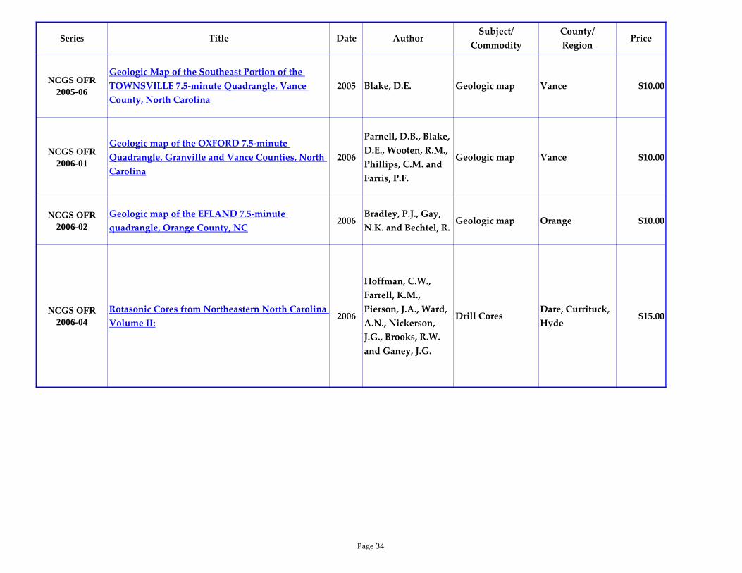
2005-06
Geologic Map of the Southeast Portion of the
TOWNSVILLE 7.5-minute Quadrangle, Vance
County, North Carolina
2005 Blake, D.E. Geologic map Vance $10.00
NCGS OFR
2006-01
Geologic map of the OXFORD 7.5-minute
Quadrangle, Granville and Vance Counties, North
Carolina
2006
Parnell, D.B., Blake,
D.E., Wooten, R.M.,
Phillips, C.M. and
Farris, P.F.
Geologic map Vance $10.00
NCGS OFR
2006-02
Geologic map of the EFLAND 7.5-minute
quadrangle, Orange County, NC2006
Bradley, P.J., Gay,
N.K. and Bechtel, R.Geologic map Orange $10.00
NCGS OFR
2006-04
Rotasonic Cores from Northeastern North Carolina
Volume II:2006
Hoffman, C.W.,
Farrell, K.M.,
Pierson, J.A., Ward,
A.N., Nickerson,
J.G., Brooks, R.W.
and Ganey, J.G.
Drill CoresDare, Currituck,
Hyde$15.00
Page 34
Series Title Date AuthorSubject/
Commodity
County/
RegionPrice
NCGS OFR
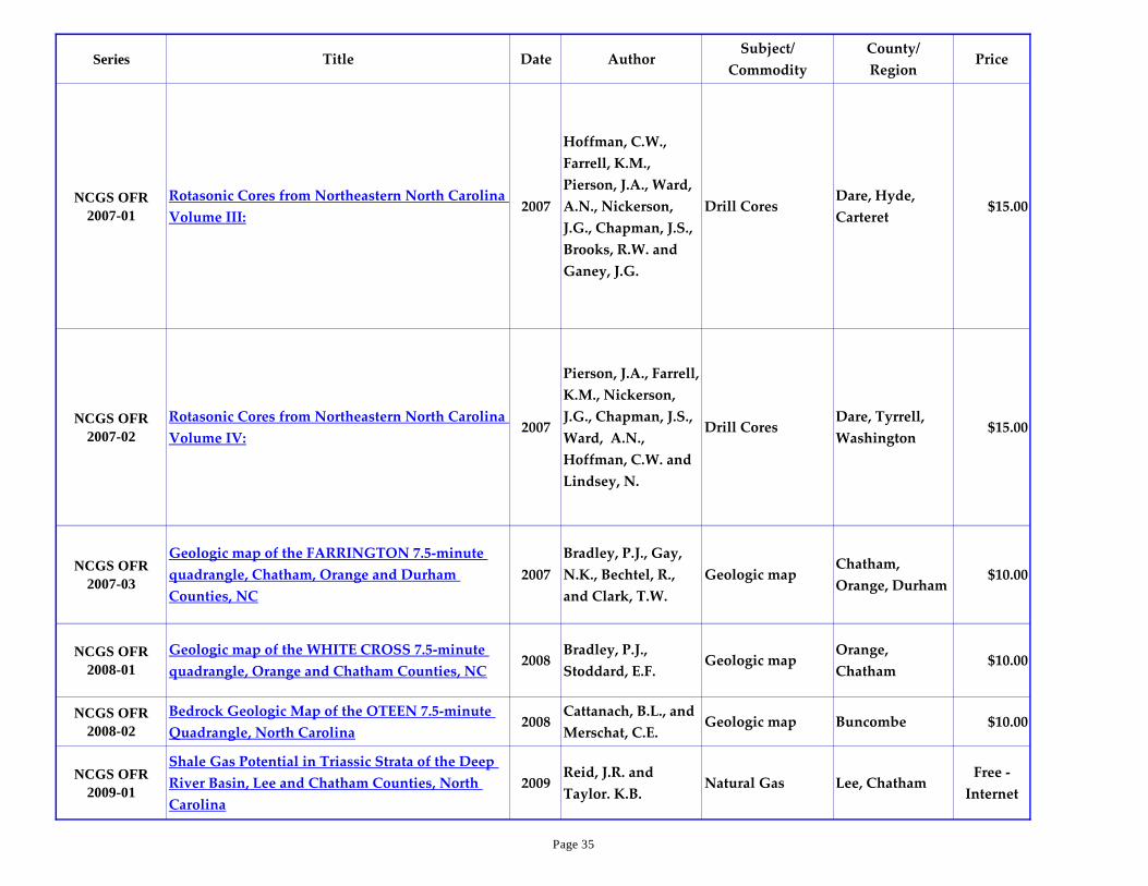
2007-01
Rotasonic Cores from Northeastern North Carolina
Volume III:2007
Hoffman, C.W.,
Farrell, K.M.,
Pierson, J.A., Ward,
A.N., Nickerson,
J.G., Chapman, J.S.,
Brooks, R.W. and
Ganey, J.G.
Drill CoresDare, Hyde,
Carteret$15.00
NCGS OFR
2007-02
Rotasonic Cores from Northeastern North Carolina
Volume IV:2007
Pierson, J.A., Farrell,
K.M., Nickerson,
J.G., Chapman, J.S.,
Ward, A.N.,
Hoffman, C.W. and
Lindsey, N.
Drill CoresDare, Tyrrell,
Washington$15.00
NCGS OFR
2007-03
Geologic map of the FARRINGTON 7.5-minute
quadrangle, Chatham, Orange and Durham
Counties, NC
2007
Bradley, P.J., Gay,
N.K., Bechtel, R.,
and Clark, T.W.
Geologic mapChatham,
Orange, Durham$10.00
NCGS OFR
2008-01
Geologic map of the WHITE CROSS 7.5-minute
quadrangle, Orange and Chatham Counties, NC2008
Bradley, P.J.,
Stoddard, E.F.Geologic map
Orange,
Chatham$10.00
NCGS OFR
2008-02
Bedrock Geologic Map of the OTEEN 7.5-minute
Quadrangle, North Carolina2008
Cattanach, B.L., and
Merschat, C.E.Geologic map Buncombe $10.00
NCGS OFR
2009-01
Shale Gas Potential in Triassic Strata of the Deep
River Basin, Lee and Chatham Counties, North
Carolina
2009Reid, J.R. and
Taylor. K.B.Natural Gas Lee, Chatham
Free -
Internet
Page 35

Series Title Date AuthorSubject/
Commodity
County/
RegionPrice
NCGS OFR
2009-02
Geologic map of the STEM 7.5-minute quadrangle,
Granville County, North Carolina2009
Blake, D.E.,
Schronce, A.G.,
Smith, B.C. and
Kendall, J.M.
Geologic map Granville $10.00
NCGS OFR
2009-03
Preliminary Bedrock Geologic map of the GOLD
SAND, CENTERVILLE, CASTALIA and JUSTICE
7.5-minute quadrangles, Franklin, Nash, Warren
and Halifax Counties, North Carolina
2009
Stoddard, E.F.,
Fuemmeler, S.,
Bechtel, R., Clark.,
T.W., and Sprinkle,
D.P.
Geologic mapFranklin, Nash,
Warren, Halifax$14.00
NCGS OFR
2009-04
Bedrock Geologic Map of the HORSE SHOE 7.5-
minute Quadrangle, North Carolina2009
Cattanach, B.L. and
Merschat, C.E.Geologic map
Henderson,
Transylvania$10.00
NCGS OFR
2010-01
Geologic map of the North Carolina Portion of the
JOHN H. KERR DAM 7.5-minute quadrangle,
Warren and Vance Counties, North Carolina
2010
Blake, D.E., Buford,
C.L., Schronce, A.G.
and Hill, D.T.
Geologic map Warren, Vance $10.00
NCGS OFR
2010-02
Geologic map of the CEDAR GROVE 7.5-minute
quadrangle, Orange, Person and Caswell Counties,
North Carolina
2010
Hanna, H.D.,
Bradley, P.J. and
Gay, N.G.
Geologic mapOrange, Person,
Caswell$10.00
NCGS OFR
2010-03
Geologic map of the CALDWELL 7.5-minute
quadrangle, Orange and Person Counties, North
Carolina
2010Bradley, P.J. and
Hanna, H.D.Geologic map Orange, Person $10.00
NCGS OFR
2010-04
Geologic map of the WHITTIER 7.5-minute
quadrangle, North Carolina2010
Cattanach, B.L. and
Bozdog, G.N.Geologic map
Jackson and
Swain$10.00
Page 36

Series Title Date AuthorSubject/
Commodity
County/
RegionPrice
NCGS OFR
2010-05
Bedrock Geologic map of the INGLESIDE 7.5-
minute quadrangle, Franklin and Vance Counties,
North Carolina
2010 Stoddard, E.F. Geologic map Franklin, Vance $10.00
NCGS OFR
2010-06
Bedrock Geologic map of the LOUISBURG 7.5-
minute quadrangle, Franklin County, North
Carolina
2010
Bechtel, R.,
Stoddard, E.F.,
Clark, T.W.,
Beaudoin, A.L.P.,
Gilliam, C. and
Antczak, G.
Geologic map Franklin $10.00
NCGS OFR
2011-01
Bedrock Geologic Map of the BREVARD 7.5-
minute Quadrangle, North Carolina2011
Cattanach, B.L. and
Bozdog, G.N.Geologic map Transylvania $10.00
NCGS OFR
2011-02
Bedrock Geologic Map of the LITTLETON 7.5-
minute Quadrangle, Warren and Halifax Counties,
North Carolina
2011
Stoddard, E.F.,
Sacks, P.E., Clark,
T.W. and Bechtel, R.
Geologic mapHalifax and
Warren$10.00
NCGS OFR
2011-03
Bedrock Geologic Map of the HOLLISTER 7.5-
minute Quadrangle, Halifax and Warren Counties,
North Carolina
2011
Sacks, P.E., Boltin,
W.R. and Stoddard,
E.F.
Geologic mapHalifax and
Warren$10.00
NCGS OFR
2011-04
Geologic Map of the Orange County and Adjacent
Portions of the SAXAPAHAW 7.5-minute
Quadrangle, Orange and Alamance Counties,
North Carolina
2011
Bradley, P.J.,
Stoddard, E.F. and
Hanna, H.D.
Geologic mapOrange and
Alamance$10.00
Page 37
Series Title Date AuthorSubject/
Commodity
County/
RegionPrice
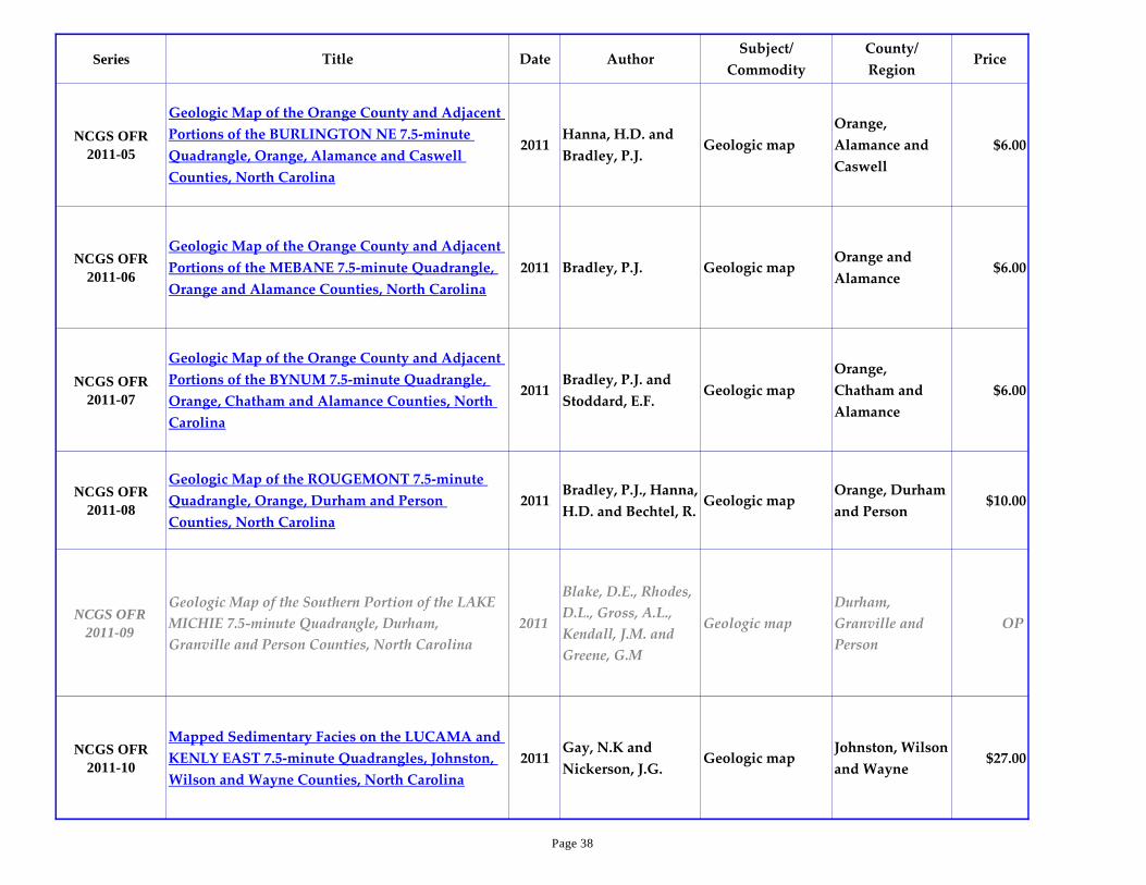
NCGS OFR
2011-05
Geologic Map of the Orange County and Adjacent
Portions of the BURLINGTON NE 7.5-minute
Quadrangle, Orange, Alamance and Caswell
Counties, North Carolina
2011Hanna, H.D. and
Bradley, P.J.Geologic map
Orange,
Alamance and
Caswell
$6.00
NCGS OFR
2011-06
Geologic Map of the Orange County and Adjacent
Portions of the MEBANE 7.5-minute Quadrangle,
Orange and Alamance Counties, North Carolina
2011 Bradley, P.J. Geologic mapOrange and
Alamance$6.00
NCGS OFR
2011-07
Geologic Map of the Orange County and Adjacent
Portions of the BYNUM 7.5-minute Quadrangle,
Orange, Chatham and Alamance Counties, North
Carolina
2011Bradley, P.J. and
Stoddard, E.F.Geologic map
Orange,
Chatham and
Alamance
$6.00
NCGS OFR
2011-08
Geologic Map of the ROUGEMONT 7.5-minute
Quadrangle, Orange, Durham and Person
Counties, North Carolina
2011Bradley, P.J., Hanna,
H.D. and Bechtel, R.Geologic map
Orange, Durham
and Person$10.00
NCGS OFR
2011-09
Geologic Map of the Southern Portion of the LAKE
MICHIE 7.5-minute Quadrangle, Durham,
Granville and Person Counties, North Carolina
2011
Blake, D.E., Rhodes,
D.L., Gross, A.L.,
Kendall, J.M. and
Greene, G.M
Geologic map
Durham,
Granville and
Person
OP
NCGS OFR
2011-10
Mapped Sedimentary Facies on the LUCAMA and
KENLY EAST 7.5-minute Quadrangles, Johnston,
Wilson and Wayne Counties, North Carolina
2011Gay, N.K and
Nickerson, J.G.Geologic map
Johnston, Wilson
and Wayne$27.00
Page 38

Series Title Date AuthorSubject/
Commodity
County/
RegionPrice
NCGS OFR
2012-01
Geologic Map of the Eastern and Central Portions
of the LAKE MICHIE 7.5-minute Quadrangle,
Durham, Granville, and Person Counties, North
Carolina
2012
Rhodes, D.L., Blake,
D.E., Morrow, R.H.,
April, J.D., Gross,
A.L. and Kendall,
J.M.
Geologic map
Durham,
Granville, and
Person
$6.00
NCGS OFR
2012-02
Geologic Map of the Northwest Portion of the
MERRY OAKS 7.5-minute Quadrangle, Chatham
and Lee Counties, North Carolina
2012
Bradley, P.J., Hanna,
H.D. and Malaska,
M.J.
Geologic mapChatham and
Lee$6.00
NCGS OFR
2012-03
Geologic Map of the Northern Portion of the
PITTSBORO 7.5-minute Quadrangle, Chatham
County, North Carolina
2012Bradley, P.J. and
Hanna, H.D.Geologic map Chatham $6.00
NCGS OFR
2012-04
Bedrock Geologic Map of the RED OAK 7.5-
minute Quadrangle, Nash County, North Carolina2012
Stoddard, E.F.,
Bechtel, R., Sacks,
P.E. and Price, L.K.
Geologic map Nash $10.00
NCGS OFR
2012-05
Bedrock Geologic Map of the PISGAH FOREST
7.5-minute Quadrangle, North Carolina2012
Cattanach, B.L.,
Wooten, R.M.,
Bozdog, G.N., and
Worley, B.D.
Geologic mapTransylvania
and Henderson$10.00
NCGS OFR
2012-06
Bedrock Geologic Map of the Southern Portion of
the CRAGGY PINNACLE 7.5-minute Quadrangle,
North Carolina
2012
Cattanach, B.L.,
Wooten, R.M. and
Bozdog, G.N.
Geologic map Buncombe OP
Page 39
Series Title Date AuthorSubject/
Commodity
County/
RegionPrice
NCGS OFR
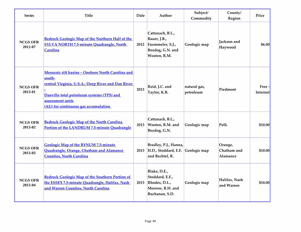
2012-07
Bedrock Geologic Map of the Northern Half of the
SYLVA NORTH 7.5-minute Quadrangle, North
Carolina
2012
Cattanach, B.L.,
Bauer, J.B.,
Fuemmeler, S.J.,
Bozdog, G.N. and
Wooten, R.M.
Geologic mapJackson and
Haywood$6.00
NCGS OFR
2013-01
Mesozoic rift basins – Onshore North Carolina and
south-
central Virginia, U.S.A.: Deep River and Dan River
-
Danville total petroleum systems (TPS) and
assessment units
(AU) for continuous gas accumulation
2013Reid, J.C. and
Taylor, K.B.
natural gas,
petroleumPiedmont
Free -
Internet
NCGS OFR
2013-02
Bedrock Geologic Map of the North Carolina
Portion of the LANDRUM 7.5-minute Quadrangle2013
Cattanach, B.L.,
Wooten, R.M. and
Bozdog, G.N.
Geologic map Polk $10.00
NCGS OFR
2013-03
Geologic Map of the BYNUM 7.5-minute
Quadrangle, Orange, Chatham and Alamance
Counties, North Carolina
2013
Bradley, P.J., Hanna,
H.D., Stoddard, E.F.
and Bechtel, R.
Geologic map
Orange,
Chatham and
Alamance
$10.00
NCGS OFR
2013-04
Bedrock Geologic Map of the Southern Portion of
the ESSEX 7.5-minute Quadrangle, Halifax, Nash
and Warren Counties, North Carolina
2013
Blake, D.E.,
Stoddard, E.F.,
Rhodes, D.L.,
Morrow, R.H. and
Buchanan, S.D.
Geologic mapHalifax, Nash
and Warren$10.00
Page 40
Series Title Date AuthorSubject/
Commodity
County/
RegionPrice
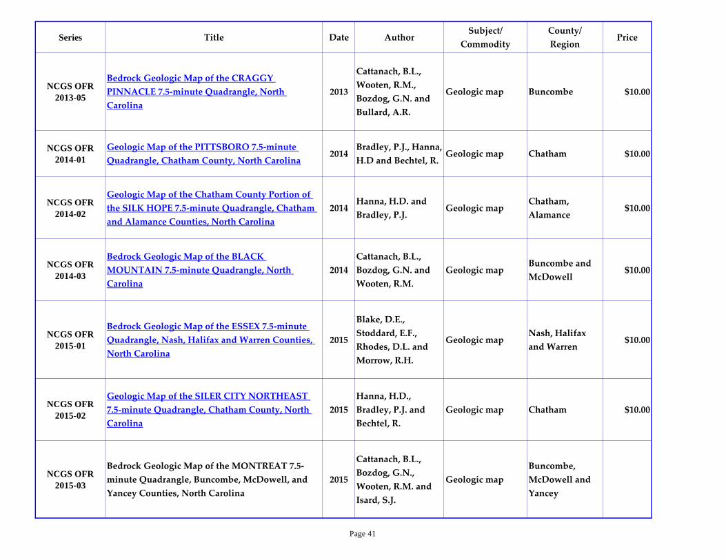
NCGS OFR
2013-05
Bedrock Geologic Map of the CRAGGY
PINNACLE 7.5-minute Quadrangle, North
Carolina
2013
Cattanach, B.L.,
Wooten, R.M.,
Bozdog, G.N. and
Bullard, A.R.
Geologic map Buncombe $10.00
NCGS OFR
2014-01
Geologic Map of the PITTSBORO 7.5-minute
Quadrangle, Chatham County, North Carolina2014
Bradley, P.J., Hanna,
H.D and Bechtel, R.Geologic map Chatham $10.00
NCGS OFR
2014-02
Geologic Map of the Chatham County Portion of
the SILK HOPE 7.5-minute Quadrangle, Chatham
and Alamance Counties, North Carolina
2014Hanna, H.D. and
Bradley, P.J.Geologic map
Chatham,
Alamance$10.00
NCGS OFR
2014-03
Bedrock Geologic Map of the BLACK
MOUNTAIN 7.5-minute Quadrangle, North
Carolina
2014
Cattanach, B.L.,
Bozdog, G.N. and
Wooten, R.M.
Geologic mapBuncombe and
McDowell$10.00
NCGS OFR
2015-01
Bedrock Geologic Map of the ESSEX 7.5-minute
Quadrangle, Nash, Halifax and Warren Counties,
North Carolina
2015
Blake, D.E.,
Stoddard, E.F.,
Rhodes, D.L. and
Morrow, R.H.
Geologic mapNash, Halifax
and Warren$10.00
NCGS OFR
2015-02
Geologic Map of the SILER CITY NORTHEAST
7.5-minute Quadrangle, Chatham County, North
Carolina
2015
Hanna, H.D.,
Bradley, P.J. and
Bechtel, R.
Geologic map Chatham $10.00
NCGS OFR
2015-03
Bedrock Geologic Map of the MONTREAT 7.5-
minute Quadrangle, Buncombe, McDowell, and
Yancey Counties, North Carolina
2015
Cattanach, B.L.,
Bozdog, G.N.,
Wooten, R.M. and
Isard, S.J.
Geologic map
Buncombe,
McDowell and
Yancey
Page 41

Series Title Date AuthorSubject/
Commodity
County/
RegionPrice
NCGS OFR
2015-04
Bedrock Geologic Map of the PEA RIDGE 7.5-
minute Quadrangle, Polk and Rutherford
Counties, North Carolina
2015
Cattanach, B.L.,
Wooten, R.M.,
Bozdog, G.N. and
Isard, S.J.
Geologic mapPolk and
Rutherford
NCGS OFR
2015-05
Geologic Map with Geomorphic Landscape
Elements of the FOUNTAIN 7.5-minute
Quadrangle, Southwest and Northeast Quadrants,
North Carolina
2015
Farrell, K.M.,
Cummings, K.L. and
Harris, W.B.
Geologic map
Wilson,
Edgecombe, Pitt
and Greene
NCGS OFR
2015-06
Dan River basin stratigraphic core hole 'Town of
Walnut Cove' (SO-C-1-15), Stokes County, North
Carolina: Preliminary results
2015
Reid, J.C., Taylor,
K.B., Marciniak,
K.J., Haven, W.T.,
Channell, R.A. and
Warner, C.I.
Core hole results Stokes
Page 42

Series Title Date AuthorSubject/
Commodity
County/
RegionPrice
NCGS OFR
2015-07
Geologic Map of FRANKLIN County, North
Carolina2015
Stoddard, E.F.,
Fuemmeler, S.,
Clark, T.W., Speer,
J.A., Grimes, W.S.,
Blake, D.E.,
Robitaille, K.R.,
Bechtel, R., Grosser,
B.D., Carpenter,
P.A., Carpenter,
R.H., Beaudoin,
A.L.P., Gilliam, C.,
Antczak, G.,
Phillips, C.M.,
Witanachchi, C.,
Ward, A.N., Farris,
P.F., Sprinkle II,
D.P., Gay, N.K.,
Kane, E.O.,
Nickerson, J.G. and
Miller, K.
Geologic map Franklin $12.00
Page 43

Series Title Date AuthorSubject/
Commodity
County/
RegionPrice
NCGS OFR
2016-02
Geologic Map of the CARY 7.5-minute
Quadrangle, Wake and Durham Counties,
North Carolina
2016Blake, D.E. and
Clark, T.W.Geologic map Wake, Durham $10.00
NCGS OFR
2016-03
Geologic Map of the APEX 7.5-minute
Quadrangle, Wake County, North Carolina2016
Stoddard, E.F.,
Clark, T.W., Gay,
N.K, and Miller, K.
Geologic map Wake $10.00
NCGS OFR
2016-04
Geologic Map of the MIDDLEBURG 7.5-
minute Quadrangle, Vance and Warren
Counties, North Carolina
2016
Stoddard, E.F.,
Blake, D.E. and
Buford, C.L.
Geologic map Vance, Warren $10.00
NCGS OFR
2016-05
Geologic Map of ORANGE County, North
Carolina2016
Bradley, P.J., Hanna,
H.D., Gay, N.K.,
Stoddard, E.F.,
Bechtel, R., Phillips,
C.M., Fuemmeler,
S.J.
Geologic map Orange $12.00
NCGS OFR
2016-06
Bedrock Geologic Map of the MONTREAT
7.5-minute Quadrangle, Buncombe,
McDowell, and Yancey Counties, North
Carolina
2016
Cattanach, B.L.,
Bozdog, G.N., Isard,
S.J., and Wooten,
R.M.
Geologic map
Buncombe,
McDowell,
Yancey
$10.00
NCGS OFR
2016-07
Bedrock Geologic Map of the PEA RIDGE 7.5-
minute Quadrangle, Polk and Rutherford
Counties, North Carolina
2016
Cattanach, B.L.,
Bozdog, G.N., Isard,
S.J., and Wooten,
R.M.
Geologic map Polk, Rutherford $10.00
Page 44

Series Title Date AuthorSubject/
Commodity
County/
RegionPrice
NCGS OFR
2016-08
Geologic Map of the Northern Third of the
SILER CITY 7.5-minute Quadrangle, Chatham
County, North Carolina
2016Hanna, H.D. and
Bradley, P.J.Geologic map Chatham $10.00
NCGS OFR
2016-09
Geologic Map of the Southern Third of the
CRUTCHFIELD CROSSROADS 7.5-minute
Quadrangle, Chatham and Alamance
Counties, North Carolina
2016Hanna, H.D. and
Bradley, P.J.Geologic map
Chatham,
Alamance$10.00
NCGS OFR
2016-10
Geologic Map of the Southeastern Corner of
the LIBERTY 7.5-minute Quadrangle,
Randolph, Chatham and Alamance, North
Carolina
2016Hanna, H.D. and
Bradley, P.J.Geologic map
Randolph,
Chatham,
Alamance
$10.00
NCGS OFR
2016-11
Geologic Map of the Northeastern Corner of
the COLERIDGE 7.5-minute Quadrangle,
Randolph, and Chatham Counties, North
Carolina
2016Bradley, P.J. and
Hanna, H.D.Geologic map
Randolph,
Chatham $10.00
NCGS OFR
2016-12
Geologic Map of the INEZ 1:24,000
Quadrangle, Warren County, North Carolina2016
Morrow, R.H. IV,
Stoddard, E.F. and
Blake, D.E.
Geologic map Warren $10.00
NCGS OFR
2016-14
Compiled Geologic Map of the GARNER 7-
5minute Quadrangle, Wake and Johnston
Counties, North Carolina
2016
Speer, J.A.,
Stoddard, E.F.,
Nickerson, J.G. and
Gay, N.K.
Geologic map Wake, Johnston $10.00
Page 45

Series Title Date AuthorSubject/
Commodity
County/
RegionPrice
NCGS OFR
2016-15
Geologic Map of the KITTRELL 7.5-minute
Quadrangle, Vance, Franklin and Granville
Counties, North Carolina
2016
Stoddard, E.F.,
Grimes, W.S., Blake,
D.E. and Robitaille,
K.R.
Geologic mapVance, Franklin,
Granville$10.00
NCGS OFR
2016-16
Geologic Map of the FRANKLINTON 7.5-
minute Quadrangle, Franklin and Wake
Counties, North Carolina
2016
Stoddard, E.F.,
Phillips, C.M.,
Witanachchi, C.D.,
Ward, A.N., Farris,
P.F., Blake, D.E. and
Clark, T.W.
Geologic map Franklin, Wake $10.00
NCGS OFR
2016-17
Bedrock Geologic Map of the HENDERSON
7.5-minute Quadrangle, Vance County, North
Carolina
2016Blake, D.E. and
Stoddard, E.F.Geologic map Vance $10.00
NCGS OFR
2016-18
Geologic Map of the CREEDMOOR 7.5-
minute Quadrangle, Granville, Wake and
Durham Counties, North Carolina
2016
Clark, T.W.,
Phillips, C.M. and
Blake, D.E.
Geologic mapGranville, Wake,
Durham$10.00
NCGS OFR
2016-19
Compiled Geologic Map of the OXFORD 7.5-
minute Quadrangle, Granville and Vance
Counties, North Carolina
2016
Parnell, D.B., Blake,
D.E., Wooten, R.M.,
Phillips, C.M. and
Farris, P.F.
Geologic map Granville, Vance $10.00
Page 46

Series Title Date AuthorSubject/
Commodity
County/
RegionPrice
NCGS OFR
2016-20
Geologic Map of the GRISSOM 7.5-minute
Quadrangle, Granville, Franklin, and Wake
Counties, North Carolina
2016
Blake, D.E.,
Phillips, C.M.,
Grosser, B.D.,
Robitaille, K.R. and
Witanachchi, C.
Geologic mapGranville,
Franklin, Wake$10.00
NCGS OFR
2016-21
Compiled Geologic Map of the WILTON 7.5-
minute Quadrangle, Granville, Vance and
Franklin Counties, North Carolina
2016
Blake, D.E.,
Robitaille, K.R.,
Phillips, C.M.,
Witanachchi, C.,
Wooten, R.M.,
Grimes, W., Pesicek,
J.D. and Grosser,
B.D.
Geologic mapGranville,
Vance, Franklin$10.00
NCGS OFR
2016-22
Geologic Map of the COKESBURY 7.5-minute
Quadrangle, Wake, Chatham and Harnett
Counties, North Carolina
2016Butler, J.R., Clark,
T.W. and Gay, N.K.Geologic map
Wake, Chatham,
Harnett$10.00
Page 47

Series Title Date AuthorSubject/
Commodity
County/
RegionPrice
NCGS OFR
2016-23
Compiled Geologic Map of DURHAM
County, North Carolina2016
Bechtel, R., Blake,
D.E., Bradley, P.J.,
Clark, T.W.,
Gallagher, P.G.,
Gay, N.K., Hanna,
H.D., Hoffman,
C.W., McConnell,
K.I., Phillips, C.M.,
Rhodes, D.L., Ward,
A.N., Watson, M.E.,
Witanachchi, C.,
April, J.D., Gross,
A.L., Kendall, J.M.
and Morrow, R.H.
Geologic map Durham $12.00
NCGS OFR 43-1Report on the development of industries in North
Carolina (The Brassert Report, 1943)1943
Brassert, H.A. and
Co.Coal, iron
Blue Ridge,
PiedmontOP
NCGS OFR 44-1War Minerals Report - Hamme Tungsten District,
Vance County, NC Final Report - Project 7531944 US Bureau of Mines Tungsten State-wide OP
NCGS OFR 54-1
Geologic Map of the Northern One-Half of the
Chapel Hill, North Carolina, Quadrangle (scale -
1:1200)
1954 Kirstein, D.S. Geologic map Orange OP
NCGS OFR 58-1 Geologic Map of the William B. Umstead Park Area 1958 Fortson, C.W. Geologic map Wake OP
Page 48
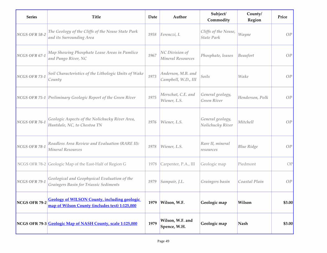
Series Title Date AuthorSubject/
Commodity
County/
RegionPrice
NCGS OFR 58-2The Geology of the Cliffs of the Neuse State Park
and its Surrounding Area1958 Ferenczi, I.
Cliffs of the Neuse,
State ParkWayne OP
NCGS OFR 67-1Map Showing Phosphate Lease Areas in Pamlico
and Pungo River, NC 1967
NC Division of
Mineral ResourcesPhosphate, leases Beaufort OP
NCGS OFR 73-1Soil Characteristics of the Lithologic Units of Wake
County1973
Anderson, M.B. and
Campbell, W.D., IIISoils Wake OP
NCGS OFR 75-1 Preliminary Geologic Report of the Green River 1975Merschat, C.E. and
Wiener, L.S.
General geology,
Green RiverHenderson, Polk OP
NCGS OFR 76-1Geologic Aspects of the Nolichucky River Area,
Huntdale, NC, to Chestoa TN1976 Wiener, L.S.
General geology,
Nolichucky RiverMitchell OP
NCGS OFR 78-1Roadless Area Review and Evaluation (RARE II):
Mineral Resources1978 Wiener, L.S.
Rare II, mineral
resourcesBlue Ridge OP
NCGS OFR 78-2 Geologic Map of the East-Half of Region G 1978 Carpenter, P.A., III Geologic map Piedmont OP
NCGS OFR 79-1Geological and Geophysical Evaluation of the
Graingers Basin for Triassic Sediments1979 Sampair, J.L. Graingers basin Coastal Plain OP
NCGS OFR 79-2Geology of WILSON County, including geologic
map of Wilson County (includes text) 1:125,0001979 Wilson, W.F. Geologic map Wilson $3.00
NCGS OFR 79-3 Geologic Map of NASH County, scale 1:125,000 1979Wilson, W.F. and
Spence, W.H.Geologic map Nash $3.00
Page 49

Series Title Date AuthorSubject/
Commodity
County/
RegionPrice
NCGS OFR 80-1North Carolina's bay lakes, the "Carolina Bays":
and update on their origin and character (draft)1980 Beyer, F.L. Carolina Bays Coastal Plain OP
NCGS OFR 80-2Geologic Map of REGION K (Franklin, Granville,
Person, Vance, & Warren Co) incl text, 1:125,0001980 McDaniel, R. Geologic map Piedmont $4.00
NCGS OFR 80-3Protraction Diagram: North Carolina Submerged
Land Leases1980
Submerged lands,
leasesCoastal Plain OP
NCGS OFR 80-4Clays and Shales of the North Carolina Piedmont
(includes map and text)1980
Allen, E.P. and
Liles, K.K.Clays and shales Piedmont OP
NCGS OFR 81-2Geology & Land Use, CHATHAM Co, Including
Geologic Map of Chatham Co (incl text) 1:125,0001981 Wilson, W.F.
Geologic map,
land useChatham County $3.00
NCGS OFR 81-3Geology and Land Use, HALIFAX Co, Including
Geologic Map of Halifax Co (incl text) 1:125,0001981 Wilson, W.F.
Geologic map,
land useHalifax $3.00
NCGS OFR 81-4
Geologic Map of REGION H (Anson,
Montgomery, Moore, & Richmond Cos) (incl text)
1:125,000
1981 Burt, E.R.Region H, geologic
mapPiedmont $4.00
NCGS OFR 81-5Geologic Map of REGION J (Chatham, Durham,
Johnston, Lee, Orange, & Wake Cos) 1:125,0001981
Wilson, W.F. and
Carpenter, P.A., III
Region J, geologic
mapPiedmont $4.00
NCGS OFR 83-1Untitled Ph.D. Dissertation (pages 423-725, with
maps)1983 Jones, G.D. Well locations State-wide OP
NCGS OFR 87-1Simple Bouguer Gravity Map of North Carolina
and Vicinity1986 Black, W.W. Gravity State-wide $12.00
NCGS OFR 87-2Residual Bouguer Gravity Map of North Carolina
and Vicinity1986 Black, W.W. Gravity State-wide $12.00
Page 50

Series Title Date AuthorSubject/
Commodity
County/
RegionPrice
NCGS OFR 87-3Lithostratigraphic-Seismic Eval of Hydrocarbon
Potential, NC Coastal and Continental Margins1987 Almy, C.C., Jr
Lithostratig,
seismic eval
Coastal & Cont
MarginsOP
NCGS OFR 88-1North Carolina Geological Survey Sample
Repository of Core, Cuttings, and Well Logs 1988
Hoffman, C.W. and
Nickerson, J.G.Sample Repository State-wide OP
NCGS OFR 88-
2,a
North Carolina Geological Survey Database Maps-
Sheet 1: Raleigh 1° x 2° Quadrangle1988
Nickerson, J.G. and
Hoffman, C.W.
Well locations,
database
Lat35°-
36°;Long78°-80°OP
NCGS OFR 88-
2,b
North Carolina Geological Survey Database Maps-
Sheet 2: Florence 1° x 2° Quadrangle1988
Nickerson, J.G. and
Hoffman, C.W.
Well locations,
database
33°50'-35°; 78°-
80°20'OP
NCGS OFR 88-
2,c
North Carolina Geological Survey Database Maps-
Sheet 3: Norfolk 1° x 2° Quadrangle1988
Nickerson, J.G. and
Hoffman, C.W.
Well locations,
database
36°-36°33'; 76°-
78°15'OP
NCGS OFR 88-
2,d
North Carolina Geological Survey Database Maps-
Sheet 4: Rocky Mount 1° x 2° Quadrangle1988
Nickerson, J.G. and
Hoffman, C.W.
Well locations,
database
Lat35°-
36°;Long76°-78°OP
NCGS OFR 88-
2,e
North Carolina Geological Survey Database Maps-
Sheet 5: Beaufort 1° x 2° Quadrangle1988
Nickerson, J.G. and
Hoffman, C.W.
Well locations,
database
33°50'-35°; 76°-
78°OP
NCGS OFR 88-
2,f
North Carolina Geological Survey Database Maps-
Sheet 6: Eastville & Manteo Quadrangles1988
Nickerson, J.G. and
Hoffman, C.W.
Well locations,
database
35°-36°33'; 75°25'-
76°OP
NCGS OFR 89-1Geologic Map of the SOUTHEAST DURHAM 7.5'
Quadrangle, North Carolina1989
Hoffman, C.W., and
Gallagher, P.E.
Triassic basin,
geologic mapDurham, Wake $6.00
NCGS OFR 89-2Geologic Map of the SOUTHWEST DURHAM 7.5'
Quadrangle, North Carolina1989
Hoffman, C.W., and
Gallagher, P.E.
Triassic basin,
geologic mapDurham, Wake $6.00
Page 51
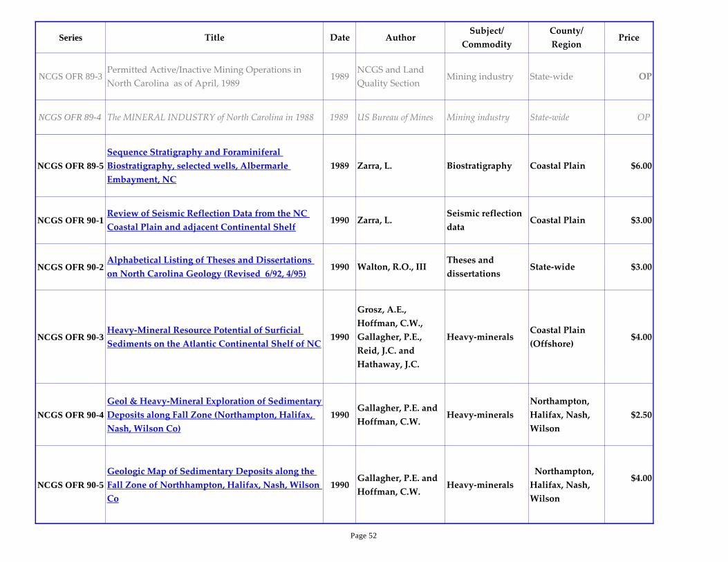
Series Title Date AuthorSubject/
Commodity
County/
RegionPrice
NCGS OFR 89-3Permitted Active/Inactive Mining Operations in
North Carolina as of April, 19891989
NCGS and Land
Quality SectionMining industry State-wide OP
NCGS OFR 89-4 The MINERAL INDUSTRY of North Carolina in 1988 1989 US Bureau of Mines Mining industry State-wide OP
NCGS OFR 89-5
Sequence Stratigraphy and Foraminiferal
Biostratigraphy, selected wells, Albermarle
Embayment, NC
1989 Zarra, L. Biostratigraphy Coastal Plain $6.00
NCGS OFR 90-1Review of Seismic Reflection Data from the NC
Coastal Plain and adjacent Continental Shelf1990 Zarra, L.
Seismic reflection
dataCoastal Plain $3.00
NCGS OFR 90-2Alphabetical Listing of Theses and Dissertations
on North Carolina Geology (Revised 6/92, 4/95)1990 Walton, R.O., III
Theses and
dissertationsState-wide $3.00
NCGS OFR 90-3Heavy-Mineral Resource Potential of Surficial
Sediments on the Atlantic Continental Shelf of NC1990
Grosz, A.E.,
Hoffman, C.W.,
Gallagher, P.E.,
Reid, J.C. and
Hathaway, J.C.
Heavy-mineralsCoastal Plain
(Offshore)$4.00
NCGS OFR 90-4
Geol & Heavy-Mineral Exploration of Sedimentary
Deposits along Fall Zone (Northampton, Halifax,
Nash, Wilson Co)
1990Gallagher, P.E. and
Hoffman, C.W.Heavy-minerals
Northampton,
Halifax, Nash,
Wilson
$2.50
NCGS OFR 90-5
Geologic Map of Sedimentary Deposits along the
Fall Zone of Northhampton, Halifax, Nash, Wilson
Co
1990Gallagher, P.E. and
Hoffman, C.W.Heavy-minerals
Northampton,
Halifax, Nash,
Wilson
$4.00
Page 52
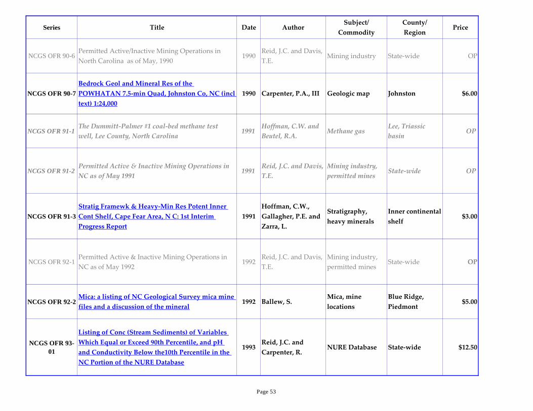
Series Title Date AuthorSubject/
Commodity
County/
RegionPrice
NCGS OFR 90-6Permitted Active/Inactive Mining Operations in
North Carolina as of May, 19901990
Reid, J.C. and Davis,
T.E.Mining industry State-wide OP
NCGS OFR 90-7
Bedrock Geol and Mineral Res of the
POWHATAN 7.5-min Quad, Johnston Co, NC (incl
text) 1:24,000
1990 Carpenter, P.A., III Geologic map Johnston $6.00
NCGS OFR 91-1The Dummitt-Palmer #1 coal-bed methane test
well, Lee County, North Carolina1991
Hoffman, C.W. and
Beutel, R.A.Methane gas
Lee, Triassic
basinOP
NCGS OFR 91-2Permitted Active & Inactive Mining Operations in
NC as of May 1991 1991
Reid, J.C. and Davis,
T.E.
Mining industry,
permitted minesState-wide OP
NCGS OFR 91-3
Stratig Framewk & Heavy-Min Res Potent Inner
Cont Shelf, Cape Fear Area, N C: 1st Interim
Progress Report
1991
Hoffman, C.W.,
Gallagher, P.E. and
Zarra, L.
Stratigraphy,
heavy minerals
Inner continental
shelf$3.00
NCGS OFR 92-1Permitted Active & Inactive Mining Operations in
NC as of May 1992 1992
Reid, J.C. and Davis,
T.E.
Mining industry,
permitted minesState-wide OP
NCGS OFR 92-2Mica: a listing of NC Geological Survey mica mine
files and a discussion of the mineral1992 Ballew, S.
Mica, mine
locations
Blue Ridge,
Piedmont$5.00
NCGS OFR 93-
01
Listing of Conc (Stream Sediments) of Variables
Which Equal or Exceed 90th Percentile, and pH
and Conductivity Below the10th Percentile in the
NC Portion of the NURE Database
1993Reid, J.C. and
Carpenter, R.NURE Database State-wide $12.50
Page 53
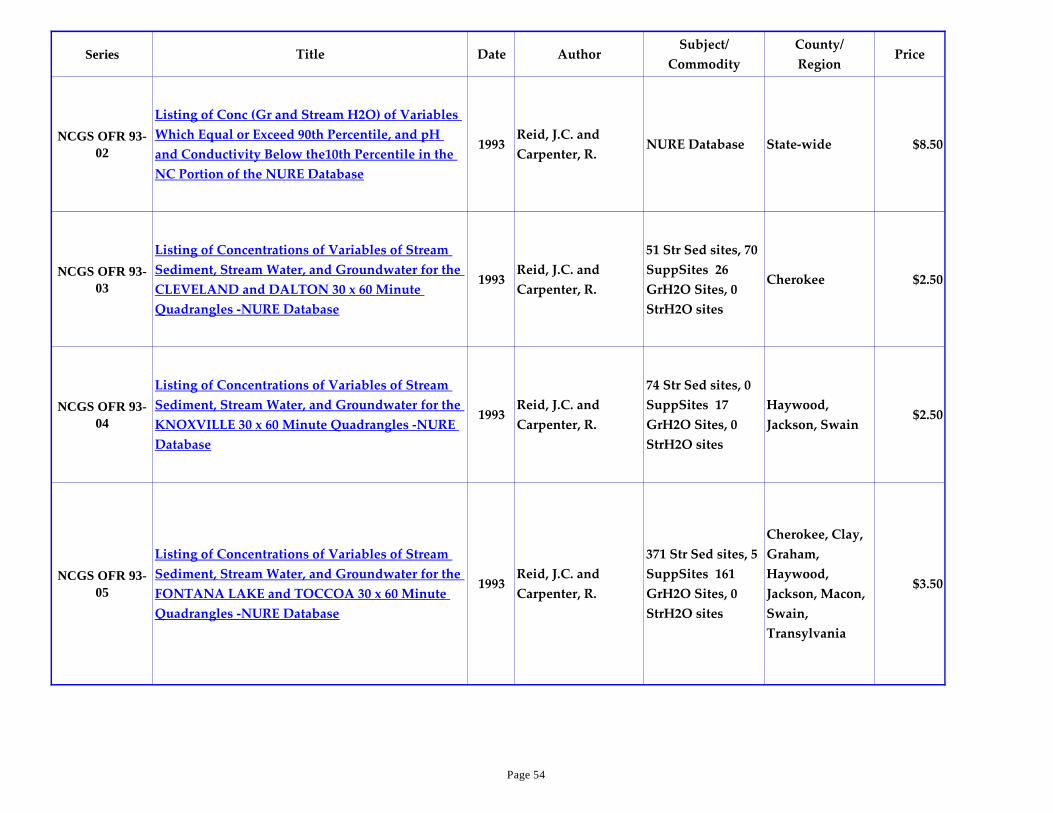
Series Title Date AuthorSubject/
Commodity
County/
RegionPrice
NCGS OFR 93-
02
Listing of Conc (Gr and Stream H2O) of Variables
Which Equal or Exceed 90th Percentile, and pH
and Conductivity Below the10th Percentile in the
NC Portion of the NURE Database
1993Reid, J.C. and
Carpenter, R.NURE Database State-wide $8.50
NCGS OFR 93-
03
Listing of Concentrations of Variables of Stream
Sediment, Stream Water, and Groundwater for the
CLEVELAND and DALTON 30 x 60 Minute
Quadrangles -NURE Database
1993Reid, J.C. and
Carpenter, R.
51 Str Sed sites, 70
SuppSites 26
GrH2O Sites, 0
StrH2O sites
Cherokee $2.50
NCGS OFR 93-
04
Listing of Concentrations of Variables of Stream
Sediment, Stream Water, and Groundwater for the
KNOXVILLE 30 x 60 Minute Quadrangles -NURE
Database
1993Reid, J.C. and
Carpenter, R.
74 Str Sed sites, 0
SuppSites 17
GrH2O Sites, 0
StrH2O sites
Haywood,
Jackson, Swain$2.50
NCGS OFR 93-
05
Listing of Concentrations of Variables of Stream
Sediment, Stream Water, and Groundwater for the
FONTANA LAKE and TOCCOA 30 x 60 Minute
Quadrangles -NURE Database
1993Reid, J.C. and
Carpenter, R.
371 Str Sed sites, 5
SuppSites 161
GrH2O Sites, 0
StrH2O sites
Cherokee, Clay,
Graham,
Haywood,
Jackson, Macon,
Swain,
Transylvania
$3.50
Page 54

Series Title Date AuthorSubject/
Commodity
County/
RegionPrice
NCGS OFR 93-
06
Listing of Concentrations of Variables of Stream
Sediment, Stream Water, and Groundwater for the
JOHNSON CITY 30 x 60 Minute Quadrangles -
NURE Database
1993Reid, J.C. and
Carpenter, R.
47 Str Sed sites, 43
SuppSites 9
GrH2O Sites, 0
StrH2O sites
Avery, Madison,
Mitchell, Yancey$2.50
NCGS OFR 93-
07
Listing of Concentrations of Variables of Stream
Sediment, Stream Water, and Groundwater for the
ASHEVILLE 30 x 60 Minute Quadrangles -NURE
Database
1993Reid, J.C. and
Carpenter, R.
355 Str Sed sites,
219 SuppSites 248
GrH2O Sites, 0
StrH2O sites
Avery,
Buncombe,
Haywood,
McDowell,
Madison,
Mitchell, Yancey
$4.50
NCGS OFR 93-
08
Listing of Concentrations of Variables of Stream
Sediment, Stream Water, and Groundwater for the
HENDERSONVILLE 30 x 60 Minute Quadrangles -
NURE Database
1993Reid, J.C. and
Carpenter, R.
256 Str Sed sites,
19 SuppSites 160
GrH2O Sites, 0
StrH2O sites
Buncombe,
Henderson,
Haywood,
Jackson, Polk,
Rutherford,
Transylvania
$3.50
NCGS OFR 93-
09
Listing of Concentrations of Variables of Stream
Sediment, Stream Water, and Groundwater for the
WYTHEVILLE and BOONE 30 x 60 Minute
Quadrangles -NURE Database
1993Reid, J.C. and
Carpenter, R.
390 Str Sed sites,
389 SuppSites 201
GrH2O Sites, 0
StrH2O sites
Alexander,
Alleghany, Ashe,
Avery, Caldwell,
Wilkes, Watauga
$5.00
Page 55

Series Title Date AuthorSubject/
Commodity
County/
RegionPrice
NCGS OFR 93-
10
Listing of Concentrations of Variables of Stream
Sediment, Stream Water, and Groundwater for the
HICKORY 30 x 60 Minute Quadrangles -NURE
Database
1993Reid, J.C. and
Carpenter, R.
350 Str Sed sites,
350 SuppSites 181
GrH2O Sites, 0
StrH2O sites
Alexander,
Avery, Burke,
Caldwell,
Cleveland,
Iredell, Lincoln,
McDowell,
Rutherford
$4.50
NCGS OFR 93-
11
Listing of Concentrations of Variables of Stream
Sediment, Stream Water, and Groundwater for the
GASTONIA 30 x 60 Minute Quadrangles -NURE
Database
1993Reid, J.C. and
Carpenter, R.
223 Str Sed sites,
223 SuppSites 132
GrH2O Sites, 0
StrH2O sites
Cleveland,
Gaston, Lincoln,
Polk, Rutherford
$3.50
NCGS OFR 93-
12
Listing of Concentrations of Variables of Stream
Sediment, Stream Water, and Groundwater for the
GALAX and WINSTON-SALEM 30 x 60 Minute
Quadrangles -NURE Database
1993Reid, J.C. and
Carpenter, R.
414 Str Sed sites,
414 SuppSites 219
GrH2O Sites, 0
StrH2O sites
Alleghany,
Davie, Forsyth,
Guilford, Iredell,
Rockingham,
Stokes, Surry,
Wilkes, Yadkin
$4.50
Page 56

Series Title Date AuthorSubject/
Commodity
County/
RegionPrice
NCGS OFR 93-
13
Listing of Concentrations of Variables of Stream
Sediment, Stream Water, and Groundwater for the
SALISBURY 30 x 60 Minute Quadrangles -NURE
Database
1993Reid, J.C. and
Carpenter, R.
301 Str Sed sites,
292 SuppSites 195
GrH2O Sites, 0
StrH2O sites
Catawba, Davie,
Davidson,
Iredell, Lincoln,
Randolph,
Rowan
$4.00
NCGS OFR 93-
14
Listing of Concentrations of Variables of Stream
Sediment, Stream Water, and Groundwater for the
CHARLOTTE 30 x 60 Minute Quadrangles -NURE
Database
1993Reid, J.C. and
Carpenter, R.
257 Str Sed sites,
255 SuppSites 185
GrH2O Sites, 0
StrH2O sites
Anson, Cabarrus,
Gaston, Lincoln,
Mecklenburg,
Montgomery,
Richmond,
Stanly, Union
$3.50
NCGS OFR 93-
15
Listing of Concentrations of Variables of Stream
Sediment, Stream Water, and Groundwater for the
LANCASTER 30 x 60 Minute Quadrangles -NURE
Database
1993Reid, J.C. and
Carpenter, R.
92 Str Sed sites, 92
SuppSites 57
GrH2O Sites, 0
StrH2O sites
Anson, Union $2.50
NCGS OFR 93-
16
Listing of Concentrations of Variables of Stream
Sediment, Stream Water, and Groundwater for the
DANVILLE and GREENSBORO 30 x 60 Minute
Quadrangles -NURE Database
1993Reid, J.C. and
Carpenter, R.
288 Str Sed sites,
288 SuppSites 211
GrH2O Sites, 0
StrH2O sites
Alamance,
Caswell,
Guilford,
Orange, Person,
Rockingham
$4.50
Page 57

Series Title Date AuthorSubject/
Commodity
County/
RegionPrice
NCGS OFR 93-
17
Listing of Concentrations of Variables of Stream
Sediment, Stream Water, and Groundwater for the
CHAPEL HILL 30 x 60 Minute Quadrangles -NURE
Database
1993Reid, J.C. and
Carpenter, R.
325 Str Sed sites,
324 SuppSites 199
GrH2O Sites, 0
StrH2O sites
Alamance,
Chatham,
Guilford, Lee,
Montgomery,
Moore, Orange,
Randolph
$4.50
NCGS OFR 93-
18
Listing of Concentrations of Variables of Stream
Sediment, Stream Water, and Groundwater for the
SOUTHERN PINES 30 x 60 Minute Quadrangles -
NURE Database
1993Reid, J.C. and
Carpenter, R.
295 Str Sed sites,
295 SuppSites 220
GrH2O Sites, 29
StrH2O sites
Anson,
Columbus,
Hoke, Harnett,
Lee,
Montgomery,
Moore,
Richmond,
Scotland
$4.50
NCGS OFR 93-
19
Listing of Concentrations of Variables of Stream
Sediment, Stream Water, and Groundwater for the
LAURINBURG and FLORENCE 30 x 60 Minute
Quadrangles -NURE Database
1993Reid, J.C. and
Carpenter, R.
157 Str Sed sites,
89 SuppSites 239
GrH2O Sites, 43
StrH2O sites
Anson,
Columbus,
Hoke, Robeson,
Richmond,
Scotland
$3.50
Page 58

Series Title Date AuthorSubject/
Commodity
County/
RegionPrice
NCGS OFR 93-
20
Listing of Concentrations of Variables of Stream
Sediment, Stream Water, and Groundwater for the
SOUTH BOSTON 30 x 60 Minute Quadrangles -
NURE Database
1993Reid, J.C. and
Carpenter, R.
401 Str Sed sites,
401 SuppSites 214
GrH2O Sites, 0
StrH2O sites
Durham,
Franklin,
Granville, Nash,
Orange, Person,
Vance, Wake,
Warren
$4.50
NCGS OFR 93-
21
Listing of Concentrations of Variables of Stream
Sediment, Stream Water, and Groundwater for the
RALEIGH 30 x 60 Minute Quadrangles -NURE
Database
1993Reid, J.C. and
Carpenter, R.
342 Str Sed sites,
299 SuppSites 198
GrH2O Sites, 3
StrH2O sites
Chatham,
Durham,
Franklin,
Harnett, Lee,
Jones, Nash,
Orange, Wake,
Wilson, Wayne
$4.50
NCGS OFR 93-
22
Listing of Concentrations of Variables of Stream
Sediment, Stream Water, and Groundwater for the
FAYETTEVILLE 30 x 60 Minute Quadrangles -
NURE Database
1993Reid, J.C. and
Carpenter, R.
237 Str Sed sites,
237 SuppSites 312
GrH2O Sites, 97
StrH2O sites
Cumberland,
Duplin, Harnett,
Johnston,
Sampson, Wayne
$4.50
NCGS OFR 93-
23
Listing of Concentrations of Variables of Stream
Sediment, Stream Water, and Groundwater for the
ELIZABETHTOWN 30 x 60 Minute Quadrangles -
NURE Database
1993Reid, J.C. and
Carpenter, R.
173 Str Sed sites,
70 SuppSites 334
GrH2O Sites, 70
StrH2O sites
Bladen,
Cumberland,
Duplin, Pender,
Robeson,
Sampson
$4.50
Page 59

Series Title Date AuthorSubject/
Commodity
County/
RegionPrice
NCGS OFR 93-
24
Listing of Concentrations of Variables of Stream
Sediment, Stream Water, and Groundwater for the
WHITEVILLE and MYRTLE BEACH 30 x 60
Minute Quadrangles -NURE Database
1993Reid, J.C. and
Carpenter, R.
164 Str Sed sites, 0
SuppSites 270
GrH2O Sites, 0
StrH2O sites
Bladen,
Brunswick,
Columbus,
Pender, Robeson
$3.50
NCGS OFR 93-
25
Listing of Concentrations of Variables of Stream
Sediment, Stream Water, and Groundwater for the
EMPORIA and ROANOKE RAPIDS 30 x 60
Minute Quadrangles -NURE Database
1993Reid, J.C. and
Carpenter, R.
252 Str Sed sites,
195 SuppSites 324
GrH2O Sites, 0
StrH2O sites
Bertie,
Edgecombe,
Halifax,
Hertford, Martin,
Nash,
Northampton,
Warren
$4.50
NCGS OFR 93-
26
Listing of Concentrations of Variables of Stream
Sediment, Stream Water, and Groundwater for the
ROCKY MOUNT 30 x 60 Minute Quadrangles -
NURE Database
1993Reid, J.C. and
Carpenter, R.
208 Str Sed sites,
70 SuppSites 286
GrH2O Sites, 6
StrH2O sites
Beaufort, Bertie,
Edgecombe,
Greene, Martin,
Nash, Pitt,
Wilson, Wayne
$3.50
NCGS OFR 93-
27
Listing of Concentrations of Variables of Stream
Sediment, Stream Water, and Groundwater for the
KINSTON 30 x 60 Minute Quadrangles -NURE
Database
1993Reid, J.C. and
Carpenter, R.
172 Str Sed sites,
35 SuppSites 287
GrH2O Sites, 22
StrH2O sites
Beaufort,
Cumberland,
Duplin, Greene,
Jones, Lenoir,
Pitt, Wayne
$3.50
Page 60

Series Title Date AuthorSubject/
Commodity
County/
RegionPrice
NCGS OFR 93-
28
Listing of Concentrations of Variables of Stream
Sediment, Stream Water, and Groundwater for the
NEW RIVER 30 x 60 Minute Quadrangles -NURE
Database
1993Reid, J.C. and
Carpenter, R.
126 Str Sed sites,
31 SuppSites 203
GrH2O Sites, 30
StrH2O sites
Craven,
Currituck,
Duplin, Jones,
Onslow, Pender
$3.50
NCGS OFR 93-
29
Listing of Concentrations of Variables of Stream
Sediment, Stream Water, and Groundwater for the
WILMINGTON and CAPE FEAR 30 x 60 Minute
Quadrangles -NURE Database
1993Reid, J.C. and
Carpenter, R.
39 Str Sed sites, 0
SuppSites 64
GrH2O Sites, 0
StrH2O sites
Brunswick, New
Hanover, Pender$2.50
NCGS OFR 93-
30
Listing of Concentrations of Variables of Stream
Sediment, Stream Water, and Groundwater for the
NORFOLK and ELIZABETH CITY 30 x 60 Minute
Quadrangles -NURE Database
1993Reid, J.C. and
Carpenter, R.
174 Str Sed sites, 0
SuppSites 246
GrH2O Sites, 0
StrH2O sites
Bertie, Currituck,
Camden, Gates,
Hertford
$3.50
NCGS OFR 93-
31
Listing of Concentrations of Variables of Stream
Sediment, Stream Water, and Groundwater for the
PLYMOUTH 30 x 60 Minute Quadrangles -NURE
Database
1993Reid, J.C. and
Carpenter, R.
67 Str Sed sites, 0
SuppSites 153
GrH2O Sites,0
StrH2O sites
Beaufort, Bertie,
Hyde, Martin,
Tyrrell,
Washington
$2.50
NCGS OFR 93-
32
Listing of Concentrations of Variables of Stream
Sediment, Stream Water, and Groundwater for the
BAYBORO 30 x 60 Minute Quadrangles -NURE
Database
1993Reid, J.C. and
Carpenter, R.
53 Str Sed sites, 0
SuppSites 131
GrH2O Sites, 0
StrH2O sites
Beaufort,
Craven, Hyde,
Pamlico
$2.50
Page 61

Series Title Date AuthorSubject/
Commodity
County/
RegionPrice
NCGS OFR 93-
33
Listing of Concentrations of Variables of Stream
Sediment, Stream Water, and Groundwater for the
MOREHEAD CITY 30 x 60 Min Quad -NURE
Database
1993Reid, J.C. and
Carpenter, R.
23 Str Sed sites, 0
SuppSites 68
GrH2O Sites, 0
StrH2O sites
Craven, Carteret,
Pamlico$2.50
NCGS OFR 93-
34
Listing of Concentrations of Variables of Stream
Sediment, Stream Water, and Groundwater for the
VA BEACH, Currituck Sound, Manteo, Cape
Hatteras 30 x 60 Minute Quadrangles -NURE
Database
1993Reid, J.C. and
Carpenter, R.
2 Str Sed sites, 0
SuppSites 34
GrH2O Sites, 0
StrH2O sites
Currituck, Dare $2.50
NCGS OFR 93-
35
Permitted Active & Inactive Mining Operations in
NC as of June, 1993 (replaces 92-1)1993
Reid, J.C.,
Carpenter, R.H. and
Davis, T.E.
Mining State-wide OP
NCGS OFR 93-
36
Compilation of Analytical Data for Phosphate-rich
Sediments in Onslow Bay, North Carolina1993
Riggs, S.R., Ames,
D., Wyrick, W.A.,
Lueck, K.L., Powers,
E.R. and Crowson,
R.A.
Miocene Geology Onslow Bay $6.00
NCGS OFR 93-
37
Heavy-mineral data for selected vibracores from
the southern inner Continental Shelf of North
Carolina
1993
Nickerson, J.G., Li,
W. and Watson,
M.E.
Heavy mineralsContinental
Shelf$3.50
Page 62
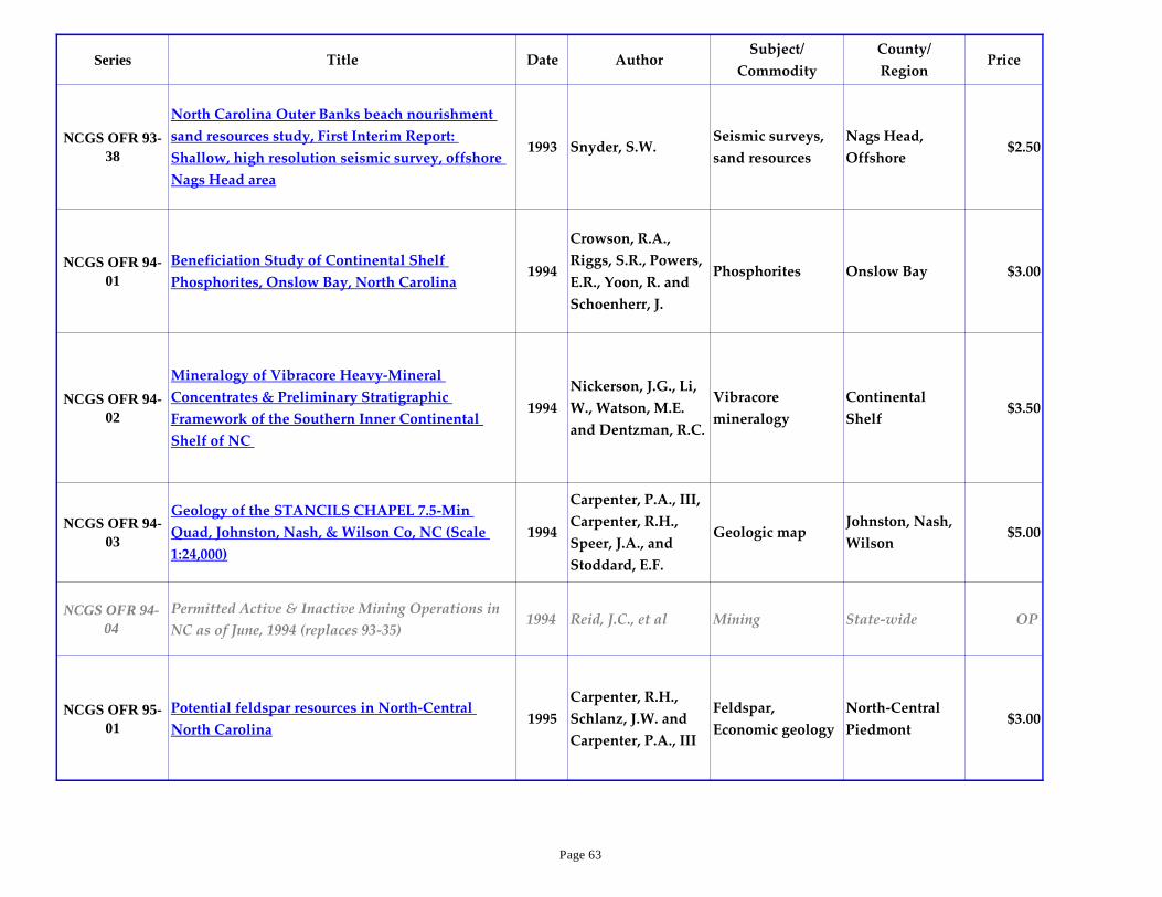
Series Title Date AuthorSubject/
Commodity
County/
RegionPrice
NCGS OFR 93-
38
North Carolina Outer Banks beach nourishment
sand resources study, First Interim Report:
Shallow, high resolution seismic survey, offshore
Nags Head area
1993 Snyder, S.W.Seismic surveys,
sand resources
Nags Head,
Offshore$2.50
NCGS OFR 94-
01
Beneficiation Study of Continental Shelf
Phosphorites, Onslow Bay, North Carolina1994
Crowson, R.A.,
Riggs, S.R., Powers,
E.R., Yoon, R. and
Schoenherr, J.
Phosphorites Onslow Bay $3.00
NCGS OFR 94-
02
Mineralogy of Vibracore Heavy-Mineral
Concentrates & Preliminary Stratigraphic
Framework of the Southern Inner Continental
Shelf of NC
1994
Nickerson, J.G., Li,
W., Watson, M.E.
and Dentzman, R.C.
Vibracore
mineralogy
Continental
Shelf$3.50
NCGS OFR 94-
03
Geology of the STANCILS CHAPEL 7.5-Min
Quad, Johnston, Nash, & Wilson Co, NC (Scale
1:24,000)
1994
Carpenter, P.A., III,
Carpenter, R.H.,
Speer, J.A., and
Stoddard, E.F.
Geologic mapJohnston, Nash,
Wilson$5.00
NCGS OFR 94-
04
Permitted Active & Inactive Mining Operations in
NC as of June, 1994 (replaces 93-35)1994 Reid, J.C., et al Mining State-wide OP
NCGS OFR 95-
01
Potential feldspar resources in North-Central
North Carolina1995
Carpenter, R.H.,
Schlanz, J.W. and
Carpenter, P.A., III
Feldspar,
Economic geology
North-Central
Piedmont$3.00
Page 63

Series Title Date AuthorSubject/
Commodity
County/
RegionPrice
NCGS OFR 96-
01
Bedrock geology of MIDDLESEX 7.5-min
quadrangle, Franklin, Johnston, Nash, & Wilson
Co.'s, NC(Scale 1:24,000)
1996
Carpenter, P.A., III,
Carpenter, R.H.,
Speer, J.A., and
Stoddard, E.F.
Geologic mapFrank, John,
Nash, WilsOP
NCGS OFR 96-
02
Bedrock geology of the ZEBULON 7.5-min
quadrangle, Franklin, Johnston, Nash, & Wake
Co.'s, NC(Scale 1:24,000)
1996
Carpenter, P.A., III,
Carpenter, R.H.,
Speer, J.A., and
Stoddard, E.F.
Geologic mapFrank, John,
Nash, WakeOP
NCGS OFR 96-
03
Bedrock geologic maps with fault and fracture data
for portions of the COKESBURY & NEW HILL 7.5-
minute quadrangles, Deep River Triassic basin, NC
1996
Wooten, R.M.,
Clark, T.W. and
Davis, T.L.
Geologic map,
fracture & fault
data
Deep River
Triassic basinOP
NCGS OFR 96-
04
Map of surficial deposits, NE quarter of the
WEAVERVILLE 7.5-minute quadrangle,NC
(1:24,000)
1996 Mills, H.H.Geologic map,
surficial deposits
Blue Ridge,
BuncombeOP
NCGS OFR 96-
05
Bedrock geologic map of the HOT SPRINGS 7.5-
minute quadrangle, NC & TN1996 Carter, M.W. Geologic map Madison and TN OP
NCGS OFR 97-
01
Permitted Active and Inactive Mining Operations in
North Carolina as of November, 19961997 Reid, J.C., et al Mining State-wide OP
NCGS OFR 97-
02
Superconducting Super Collider: Location,
Geology, and Road Log1997
Wilson, W.F. and
Carpenter, P.A., IIIGeology
Granville,
Person, Durham$5.00
Page 64
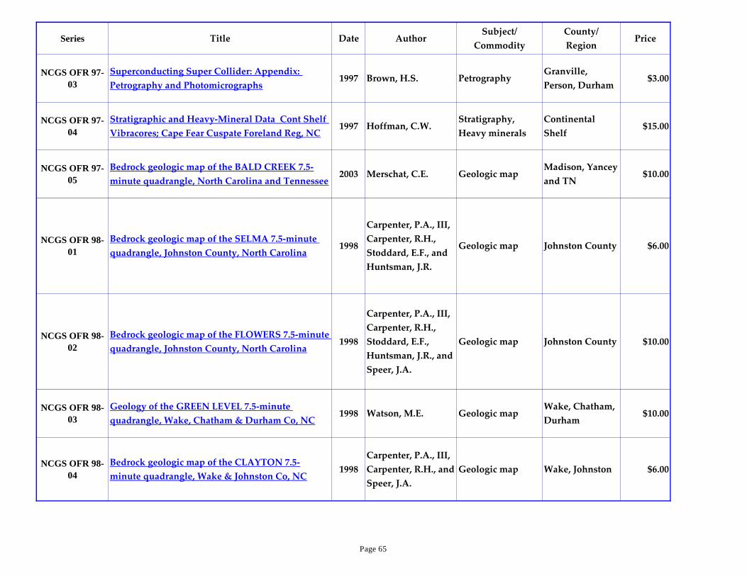
Series Title Date AuthorSubject/
Commodity
County/
RegionPrice
NCGS OFR 97-
03
Superconducting Super Collider: Appendix:
Petrography and Photomicrographs1997 Brown, H.S. Petrography
Granville,
Person, Durham$3.00
NCGS OFR 97-
04
Stratigraphic and Heavy-Mineral Data Cont Shelf
Vibracores; Cape Fear Cuspate Foreland Reg, NC1997 Hoffman, C.W.
Stratigraphy,
Heavy minerals
Continental
Shelf$15.00
NCGS OFR 97-
05
Bedrock geologic map of the BALD CREEK 7.5-
minute quadrangle, North Carolina and Tennessee2003 Merschat, C.E. Geologic map
Madison, Yancey
and TN$10.00
NCGS OFR 98-
01
Bedrock geologic map of the SELMA 7.5-minute
quadrangle, Johnston County, North Carolina1998
Carpenter, P.A., III,
Carpenter, R.H.,
Stoddard, E.F., and
Huntsman, J.R.
Geologic map Johnston County $6.00
NCGS OFR 98-
02
Bedrock geologic map of the FLOWERS 7.5-minute
quadrangle, Johnston County, North Carolina1998
Carpenter, P.A., III,
Carpenter, R.H.,
Stoddard, E.F.,
Huntsman, J.R., and
Speer, J.A.
Geologic map Johnston County $10.00
NCGS OFR 98-
03
Geology of the GREEN LEVEL 7.5-minute
quadrangle, Wake, Chatham & Durham Co, NC1998 Watson, M.E. Geologic map
Wake, Chatham,
Durham$10.00
NCGS OFR 98-
04
Bedrock geologic map of the CLAYTON 7.5-
minute quadrangle, Wake & Johnston Co, NC1998
Carpenter, P.A., III,
Carpenter, R.H., and
Speer, J.A.
Geologic map Wake, Johnston $6.00
Page 65

Series Title Date AuthorSubject/
Commodity
County/
RegionPrice
NCGS OFR 98-
05
Bedrock geologic map of the LAKE WHEELER 7.5-
minute quadrangle, Wake County, North Carolina1998
Stoddard, E.F., and
Heller, M.Geologic map Wake OP
NCGS OFR 98-
06
Bedrock geologic map of the RALEIGH EAST 7.5-
minute quadrangle, Wake County, North Carolina1998
Speer, J.A.,
Carpenter, P.A., III,
and Carpenter, R.H.
Geologic map Wake $10.00
NCGS OFR 99-
01
Bedrock geologic map of the ERECT 7.5-minute
quadrangle, Randolph County, North Carolina1999 Carpenter, P.A., III Geologic map Randolph $6.00
RGS 1Region J Geology: A Guide for NC Min Res Devel &
Land Use Planning w/geol map, 1:250,0001975
Wilson, W.F. and
Carpenter, P.A., III
Geologic mapping,
environmental
geology
Region J,
PiedmontOP
RGS 2
Geologic Map of Region G (Alamance, Caswell,
Davidson, Guilford, Randolph, and Rockingham
Cos)
1982 Carpenter, P.A., III
Geologic mapping,
environmental
geology
Region G,
Piedmont$7.00
Special Pub 1Geology of the CHAPEL HILL Quadrangle, North
Carolina1965
Mann, V.I., Clarke,
T.G., Hayes, L.D.,
and Kirstein, D.S.
Geologic mappingOrange, Chapel
Hill quadOP
Special Pub 2Triassic Flora from the Deep River Basin, North
Carolina (REPRINT 1995)1969
Hope, R.C. and
Patterson, O.F., III
Fossils, Triassic
floraLee OP
Special Pub 3Upper Miocene Foraminifera from near
Grimesland, Pitt County, North Carolina1970 Schnitker, D.
Foraminifera,
biostartigraphyPitt $3.00
Page 66
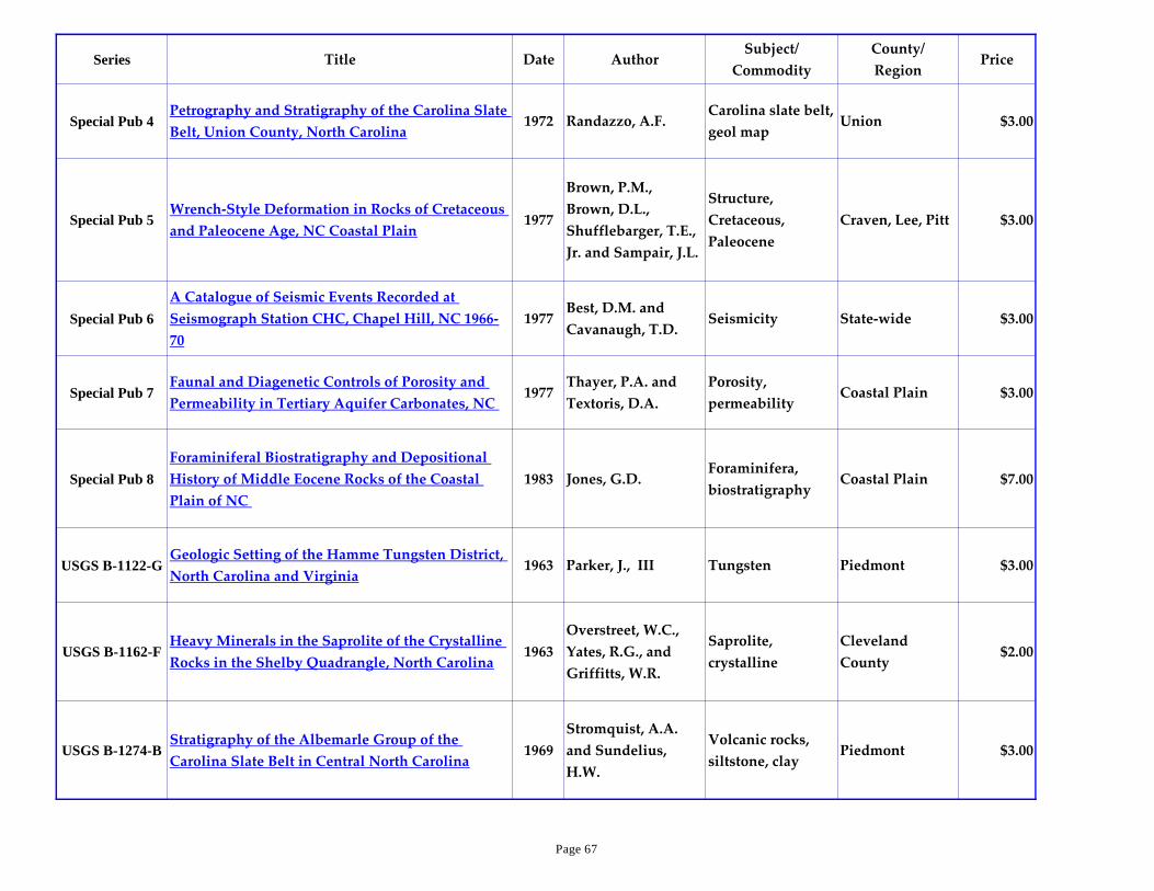
Series Title Date AuthorSubject/
Commodity
County/
RegionPrice
Special Pub 4Petrography and Stratigraphy of the Carolina Slate
Belt, Union County, North Carolina1972 Randazzo, A.F.
Carolina slate belt,
geol mapUnion $3.00
Special Pub 5Wrench-Style Deformation in Rocks of Cretaceous
and Paleocene Age, NC Coastal Plain1977
Brown, P.M.,
Brown, D.L.,
Shufflebarger, T.E.,
Jr. and Sampair, J.L.
Structure,
Cretaceous,
Paleocene
Craven, Lee, Pitt $3.00
Special Pub 6
A Catalogue of Seismic Events Recorded at
Seismograph Station CHC, Chapel Hill, NC 1966-
70
1977Best, D.M. and
Cavanaugh, T.D.Seismicity State-wide $3.00
Special Pub 7Faunal and Diagenetic Controls of Porosity and
Permeability in Tertiary Aquifer Carbonates, NC 1977
Thayer, P.A. and
Textoris, D.A.
Porosity,
permeabilityCoastal Plain $3.00
Special Pub 8
Foraminiferal Biostratigraphy and Depositional
History of Middle Eocene Rocks of the Coastal
Plain of NC
1983 Jones, G.D.Foraminifera,
biostratigraphyCoastal Plain $7.00
USGS B-1122-GGeologic Setting of the Hamme Tungsten District,
North Carolina and Virginia1963 Parker, J., III Tungsten Piedmont $3.00
USGS B-1162-FHeavy Minerals in the Saprolite of the Crystalline
Rocks in the Shelby Quadrangle, North Carolina1963
Overstreet, W.C.,
Yates, R.G., and
Griffitts, W.R.
Saprolite,
crystalline
Cleveland
County$2.00
USGS B-1274-BStratigraphy of the Albemarle Group of the
Carolina Slate Belt in Central North Carolina1969
Stromquist, A.A.
and Sundelius,
H.W.
Volcanic rocks,
siltstone, clayPiedmont $3.00
Page 67

Series Title Date AuthorSubject/
Commodity
County/
RegionPrice
USGS B-1314-E
Organic and Trace-Element Content of Holocene
Sediments in Two Estuarine Bays, Pamlico Sound
Area, North Carolina
1972
Berryhill, H.L., Jr.,
Swanson, V.E. and
Love, A.H.
Holocene
sedimentsPamlico Sound $2.00
USGS B-1416Mineral Resources of the Joyce Kilmer-Slickrock
Wilderness, North Carolina-Tennessee1977
Lesure, F.G., Force,
E.R., Windolph, J.G.
and Hill, J.J.
Mineral Resources Blue Ridge $5.00
USGS B-1502-B
Stratigraphy of Upper Pliocene and Lower
Pleistocene Marine and Estuarine Deposits of
Northeastern North Carolina and Southeastern
Virginia
1981 Blackwelder, B.W. Marine deposits
Northeastern NC
and
Southeastern VA
$2.00
USGS B-1515
Mineral Resources of the Craggy Mountain
Wilderness Study Area and Extension, Buncombe
County, North Carolina
1982
Lesure, F.G., Grosz,
A.E., Williams, B.B.
and Gazdik, G.C.
Mineral Resources Blue Ridge $3.00
USGS B-1979Bedrock Geology and Mineral Resources of the
Knoxville 1° X 2° Quadrangle, TN, NC & SC 1992
Robinson, G.R., Jr.,
Lesure, F.G.,
Marlowe, J.I., II,
Foley, N.K. and
Clark, S.H.
Geologic Map,
Mineral ResourcesBlue Ridge $9.00
USGS B-2005
Geology and Mineral Resource Potential of the
Chattanooga 1x2 degree Quadrangle, TN & NC - A
Preliminary Assessment
1993
Clark, S.H.B,
Spanski, G.T.,
Hadley, D.G. and
Hofstra, A.F.
Geology &
mineral resourcesBlue Ridge $5.00
USGS B-936-AMuscovite in the Spruce Pine District North
Carolina1942
Kesler, T.L. and
Olson, J.C.Muscovite
Spruce Pine
District$3.00
Page 68
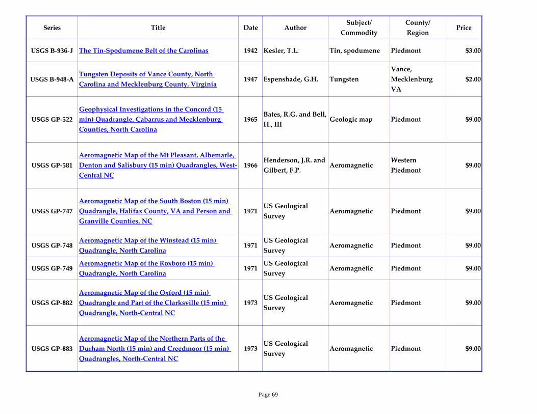
Series Title Date AuthorSubject/
Commodity
County/
RegionPrice
USGS B-936-J The Tin-Spodumene Belt of the Carolinas 1942 Kesler, T.L. Tin, spodumene Piedmont $3.00
USGS B-948-ATungsten Deposits of Vance County, North
Carolina and Mecklenburg County, Virginia1947 Espenshade, G.H. Tungsten
Vance,
Mecklenburg
VA
$2.00
USGS GP-522
Geophysical Investigations in the Concord (15
min) Quadrangle, Cabarrus and Mecklenburg
Counties, North Carolina
1965Bates, R.G. and Bell,
H., IIIGeologic map Piedmont $9.00
USGS GP-581
Aeromagnetic Map of the Mt Pleasant, Albemarle,
Denton and Salisbury (15 min) Quadrangles, West-
Central NC
1966Henderson, J.R. and
Gilbert, F.P.Aeromagnetic
Western
Piedmont$9.00
USGS GP-747
Aeromagnetic Map of the South Boston (15 min)
Quadrangle, Halifax County, VA and Person and
Granville Counties, NC
1971US Geological
SurveyAeromagnetic Piedmont $9.00
USGS GP-748Aeromagnetic Map of the Winstead (15 min)
Quadrangle, North Carolina1971
US Geological
SurveyAeromagnetic Piedmont $9.00
USGS GP-749Aeromagnetic Map of the Roxboro (15 min)
Quadrangle, North Carolina1971
US Geological
SurveyAeromagnetic Piedmont $9.00
USGS GP-882
Aeromagnetic Map of the Oxford (15 min)
Quadrangle and Part of the Clarksville (15 min)
Quadrangle, North-Central NC
1973US Geological
SurveyAeromagnetic Piedmont $9.00
USGS GP-883
Aeromagnetic Map of the Northern Parts of the
Durham North (15 min) and Creedmoor (15 min)
Quadrangles, North-Central NC
1973US Geological
SurveyAeromagnetic Piedmont $9.00
Page 69

Series Title Date AuthorSubject/
Commodity
County/
RegionPrice
USGS GP-885
Aeromagnetic Map of the Norlina (15 min)
Quadrangle and Parts of the Castalia (15 min) and
South Hill (15 min) Quadrangles, North-Central
NC
1973US Geological
SurveyAeromagnetic Piedmont $9.00
USGS GP-886Aeromagnetic Map of the Essex-Roanoke Rapids
Area, Northeastern NC1973
US Geological
SurveyAeromagnetic Piedmont $9.00
USGS GP-958Aeromagnetic Map of North Carolina: in color
(Scale 1:1,000,000)1984
Zietz, I., Riggle, F.E.
and Gilbert, F.P.Aeromagnetic State-wide $9.00
USGS GQ-242Geology of the Lenoir Quadrangle, North Carolina
(Scale 1:62,500)1964 Reed, J.C., Jr. Geologic map Blue Ridge $9.00
USGS GQ-364Geology of the Linville Quadrangle, North
Carolina (Scale 1:62,500)1965 Bryant, B. Geologic map
Blue Ridge
Mountains$9.00
USGS GQ-872Geologic Map of the Denton Quadrangle, North
Carolina (Scale 1:62,500)1971
Stromquist, A.A.,
Choquette, P.W. and
Sundelius, H.W.
Geologic map Piedmont $9.00
USGS HA-264Water-Bearing Characteristics and Occurrence of
Aquifers in Martin County, NC1967 Wyrick, G.G. Aquifers Coastal Plain $9.00
USGS HA-291Summary of the Geology and Ground-Water
Resources of Pitt County, NC1968 Sumsion, C.T. Groundwater Coastal Plain $9.00
USGS HA-292 Ground-Water Resources of Chowan County, NC 1968 Lloyd, O.B., Jr. Groundwater Coastal Plain $9.00
USGS HA-331Floods on the Little Buffalo Creek at West
Jefferson, North Carolina1969 Haire, W.J.
Hydrologic
Investigations
Blue Ridge
Mountains$9.00
Page 70

Series Title Date AuthorSubject/
Commodity
County/
RegionPrice
USGS HA-343Groundwater Resources of Craven County, North
Carolina1969 Floyd, E.O. Groundwater Coastal Plain $9.00
USGS HA-439Chemical Quality of Water in Streams of North
Carolina1971
Wilder, H.B. and
Slack, L.J.
Hydrologic
InvestigationsState-wide $9.00
USGS HA-540Groundwater Resources of the Cape Hatteras
National Seashore, North Carolina1975 Winner, M.D., Jr.
Hydrologic
InvestigationsCoastal Plain $9.00
USGS I-1082
Interpretive Geologic Map of Bedrock, Mt.
Pleasant Quadrangle, Cabarrus & Stanley Counties
NC (Scale 1:48,000)
1978
Sundelius, H.W.
and Stromquist,
A.A.
Geologic map Piedmont $9.00
USGS I-1251-ASimple Bouguer Gravity Map of the Charlotte 1° X
2° Quadrangle, NC & SC (Scale 1:250,000)1980
Wilson, F.A. and
Daniels, D.L.Geologic map Piedmont $9.00
USGS I-1251-BAeromagnetic Map of the Charlotte 1° X 2°
Quadrangle, NC & SC (Scale 1:250,000)1981
Daniels, D.L. and
Zietz, I.
Aeromagnetic
MapPiedmont $9.00
USGS I-1251-CAeromagnetic Map (IN COLOR) of the Charlotte
1° X 2° Quadrangle, NC & SC (Scale 1:250,000)1981
Daniels, D.L. and
Zietz, I.
Aeromagnetic
MapPiedmont $9.00
USGS I-1251-DAeroradioactivity Map of the Charlotte 1x2 degree
Quadrangle, NC & SC: In color1982
Daniels, D.L. and
Zietz, I.
Aeroradioactivity
MapPiedmont $9.00
USGS I-1251-EGeologic Map of the Charlotte 1° X 2° Quadrangle,
NC & SC (Scale 1:250,000) 1988
Goldsmith, R.,
Milton, D.J. and
Horton, J.W., Jr.
Geologic map Piedmont $9.00
USGS I-1251-FMineral Production Maps of the Charlotte 1° X 2°
Quadrangle, NC & SC (Scale 1:250,000)1985
DeYoung, J.H., Lee,
M.P. and Dorian,
J.P.
Geologic maps Piedmont $9.00
Page 71

Series Title Date AuthorSubject/
Commodity
County/
RegionPrice
USGS I-1251-G
Mineral Resource Potential for Copper, Lead, Zinc
and Combined Base Metals in the Charlotte 1x2
Quadrangle, NC & SC
1986Gair, J.E. and
Griffitts, W.R.Mineral Resources Piedmont $9.00
USGS I-1251-H
Mineral Resource Potential for Gold in the
Charlotte 1° X 2° Quadrangle, NC & SC (Scale
1:250,000)
1986Gair, J.E. and D'
Agostino, J.P.
Gold, Mineral
ResourcesPiedmont $7.00
USGS I-1251-IMineral Resource Potential for Tin and Tungsten
in the Charlotte 1x2 degree Quadrangle, NC & SC1986 Gair, J.E. Mineral Resources Piedmont $9.00
USGS I-1251-J
Mineral Resource Potential for Beryllium,
Molybdenum and Niobium in the Charlotte 1x2
Degree Quadrangle, North Carolina and South
Carolina
1986 Gair, J.E.
Beryllium,
Molybdenum,
Niobium
Piedmont $9.00
USGS I-1251-K
Mineral Resource Potential for Lithium, Kyanite-
Sillimanite, and Barite in the Charlotte 1x2 degree
Quadrangle, NC & SC
1987 Horton, J.W., Jr. Mineral Resources Piedmont $9.00
USGS I-1251-L
Mineral Resource Potential for Uranium and
Thorium in the Charlotte 1x2 degree Quadrangle,
NC & SC
1986 Gair, J.E. Mineral Resources Piedmont $9.00
USGS I-1251-M
Resource Potential for Crushed Stone, Sand and
Gravel, and Clay in the Charlotte 1x2 degree
Quadrangle, NC & SC
1986
Goldsmith, R.,
Horton, J.W., Jr.,
Milton, D.J., Gair,
J.E. and D'Agostino,
J.P.
Mineral Resources Piedmont $9.00
Page 72
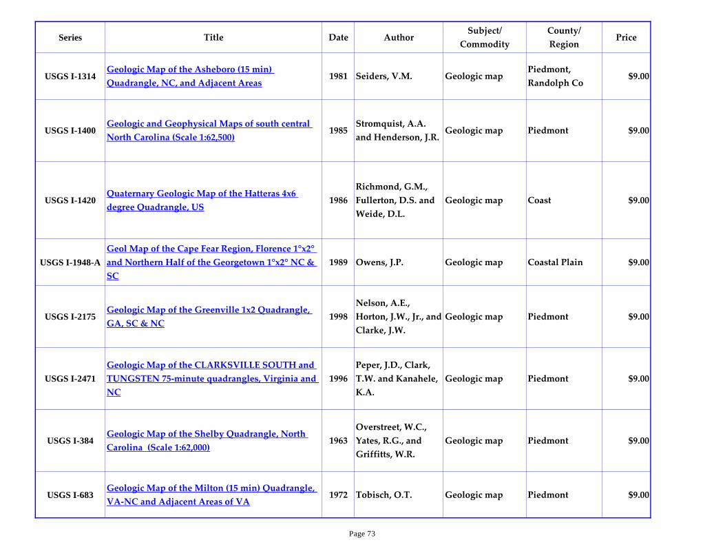
Series Title Date AuthorSubject/
Commodity
County/
RegionPrice
USGS I-1314Geologic Map of the Asheboro (15 min)
Quadrangle, NC, and Adjacent Areas1981 Seiders, V.M. Geologic map
Piedmont,
Randolph Co$9.00
USGS I-1400Geologic and Geophysical Maps of south central
North Carolina (Scale 1:62,500)1985
Stromquist, A.A.
and Henderson, J.R.Geologic map Piedmont $9.00
USGS I-1420Quaternary Geologic Map of the Hatteras 4x6
degree Quadrangle, US1986
Richmond, G.M.,
Fullerton, D.S. and
Weide, D.L.
Geologic map Coast $9.00
USGS I-1948-A
Geol Map of the Cape Fear Region, Florence 1°x2°
and Northern Half of the Georgetown 1°x2° NC &
SC
1989 Owens, J.P. Geologic map Coastal Plain $9.00
USGS I-2175Geologic Map of the Greenville 1x2 Quadrangle,
GA, SC & NC1998
Nelson, A.E.,
Horton, J.W., Jr., and
Clarke, J.W.
Geologic map Piedmont $9.00
USGS I-2471
Geologic Map of the CLARKSVILLE SOUTH and
TUNGSTEN 75-minute quadrangles, Virginia and
NC
1996
Peper, J.D., Clark,
T.W. and Kanahele,
K.A.
Geologic map Piedmont $9.00
USGS I-384Geologic Map of the Shelby Quadrangle, North
Carolina (Scale 1:62,000)1963
Overstreet, W.C.,
Yates, R.G., and
Griffitts, W.R.
Geologic map Piedmont $9.00
USGS I-683Geologic Map of the Milton (15 min) Quadrangle,
VA-NC and Adjacent Areas of VA1972 Tobisch, O.T. Geologic map Piedmont $9.00
Page 73

Series Title Date AuthorSubject/
Commodity
County/
RegionPrice
USGS I-709-AGeologic Map of the West Half of the Winston-
Salem quadrangle, NC, VA, TN (Scale 1:250,000)1972
Rankin, D.W.,
Espenshade, G.H.
and Neuman, R.B.
Geologic mapInner Piedmont,
Blue Ridge$9.00
USGS I-709-BGeologic Map of the East Half of the Winston-
Salem quadrangle, NC & VA (Scale 1:250,000)1975
Espenshade, G.H.,
Rankin, D.W.,
Shaw, K.W. and
Neuman, R.B.
Geologic mapInner Piedmont,
Piedmont$9.00
USGS I-888
Interpret Geol Map of the Bedrock showing
Radioact, & Aeromag Map of Salisbury,
Southmont, Rockwell, & Gold Hill Qds (Scale
1:48,000)
1975
Stromquist, A.A.
and Sundelius,
H.W.
Geologic map Piedmont $9.00
USGS MF-1287-
D
Mineral Resource Potential, Ellicott Rock
Wilderness and Additions, NC, SC, GA1983
Luce, R.W., Bell, H.,
III, and Gazdik,
G.C.
Mineral Resources Mountains $9.00
USGS MF-1290-
A
Geology of the Shining Rock Wilderness,
Haywood County, NC1981 Lesure, F.G. Geologic map Mountains $9.00
USGS MF-1290-
B
Geochemical Survey of Shining Rock Wilderness,
Haywood County, NC1981 Lesure, F.G. Geochemical map Mountains $9.00
USGS MF-1290-
C
Mineral Resource Potential of the Shining Rock
Wilderness, Haywood County, NC1982 Lesure, F.G. Mineral Resources Mountains $9.00
USGS MF-1391-
C
Maps Showing Uranium Prospects and
Mineralization in the Lost Cove and Harper Creek
Roadless Areas, Avery and Caldwell Counties, NC
1986Ross, R.B., Jr. and
Crandall, T.M.Mineral Resources Mountains $9.00
Page 74
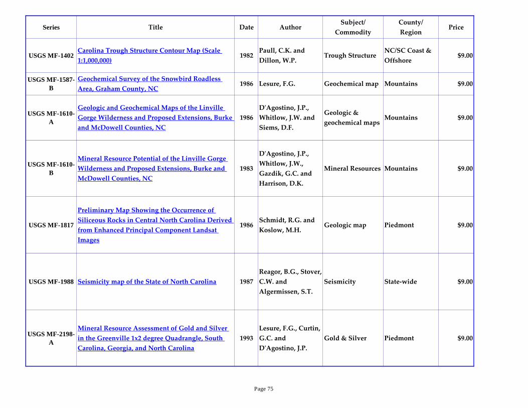
Series Title Date AuthorSubject/
Commodity
County/
RegionPrice
USGS MF-1402Carolina Trough Structure Contour Map (Scale
1:1,000,000)1982
Paull, C.K. and
Dillon, W.P.Trough Structure
NC/SC Coast &
Offshore$9.00
USGS MF-1587-
B
Geochemical Survey of the Snowbird Roadless
Area, Graham County, NC1986 Lesure, F.G. Geochemical map Mountains $9.00
USGS MF-1610-
A
Geologic and Geochemical Maps of the Linville
Gorge Wilderness and Proposed Extensions, Burke
and McDowell Counties, NC
1986
D'Agostino, J.P.,
Whitlow, J.W. and
Siems, D.F.
Geologic &
geochemical mapsMountains $9.00
USGS MF-1610-
B
Mineral Resource Potential of the Linville Gorge
Wilderness and Proposed Extensions, Burke and
McDowell Counties, NC
1983
D'Agostino, J.P.,
Whitlow, J.W.,
Gazdik, G.C. and
Harrison, D.K.
Mineral Resources Mountains $9.00
USGS MF-1817
Preliminary Map Showing the Occurrence of
Siliceous Rocks in Central North Carolina Derived
from Enhanced Principal Component Landsat
Images
1986Schmidt, R.G. and
Koslow, M.H.Geologic map Piedmont $9.00
USGS MF-1988 Seismicity map of the State of North Carolina 1987
Reagor, B.G., Stover,
C.W. and
Algermissen, S.T.
Seismicity State-wide $9.00
USGS MF-2198-
A
Mineral Resource Assessment of Gold and Silver
in the Greenville 1x2 degree Quadrangle, South
Carolina, Georgia, and North Carolina
1993
Lesure, F.G., Curtin,
G.C. and
D'Agostino, J.P.
Gold & Silver Piedmont $9.00
Page 75

Series Title Date AuthorSubject/
Commodity
County/
RegionPrice
USGS MF-2215-
C
Gold Occurrences in the Greenville 1x2 degree
Quadrangle, South Carolina, Georgia, and North
Carolina
1994
D'Agostino, J.P.,
Mason, G.T., Zupan,
A.J.W., Maybin,
A.H., III, German,
J.M. and Abrams,
C.E.
Gold Piedmont $9.00
USGS MF-2223
Preliminary Geology and Geochemistry of Rocks
and Sarolite in part of the FRANKLIN Quadrangle,
Macon County, North Carolina
1993Lesure, F.G. and
Force, E.R.Geologic map Mountains $9.00
USGS MF-2285Geologic Map of the BRACEY 75-minute
Quadrangle, VA & NC (Scale 1:24,000)1996 Sacks, P.E. Geologic map Piedmont $9.00
USGS MF-2286
Geologic Map of the SOUTH HILL SE 7.5-minute
Quadrangle, Mecklenburg and Brunswick
Counties, Virginia, and Warren County, North
Carolina
1996 Sacks, P.E. Geologic map Piedmont $9.00
USGS MF-2287
Geologic Map of the GASBURG 7.5-minute
Quadrangle, Brunswick County, Virginia, and
Warren, Northampton, and Halifax Counties,
North Carolina
1996 Sacks, P.E. Geologic map Piedmont $9.00
USGS MF-2288
Geologic Map of the VALENTINES 7.5-minute
Quadrangle, Brunswick and Greensville Counties,
Virginia and Northampton and Halifax Counties,
North Carolina
1996 Sacks, P.E. Geologic map Piedmont $9.00
Page 76

Series Title Date AuthorSubject/
Commodity
County/
RegionPrice
USGS MF-234
Geochemical and Heavy-Mineral Reconnaissance
of the CONCORD Quadrangle, Cabarrus County,
NC
1960Bell, H., III, and
Overstreet, W.C.Geochemical map Piedmont $9.00
USGS MF-235
Geochemical and Heavy-Mineral Reconnaissance
of the CONCORD SE Quadrangle, Cabarrus
County, NC
1960Overstreet, W.C.
and Bell, H., IIIGeochemical map Piedmont $9.00
USGS MF-268Geochemical and Heavy-Mineral Reconnaissance
of the KANNAPOLIS Quadrangle, NC1963 Bell, H., III Geochemical map Piedmont $9.00
USGS MF-272Geochemical and Heavy-Mineral Reconnaissance
of the HARRISBURG Quadrangle, NC1964 Bell, H., III Geochemical map Piedmont $9.00
USGS MF-608Geologic Map of the OXFORD (15 min)
Quadrangle, Granville and Vance Counties, NC1974 Hadley, J.B. Geologic map Piedmont $9.00
USGS PP-1177-
BThe Outer Banks of North Carolina 1986
Dolan, R. and Lins,
H.Barrier Islands Coastal Plain $13.50
USGS PP-1285
The Black Creek-Peedee Formational Contact
(Upper Cretaceous) in the Cape Fear River Region
of North Carolina
1983Sohl, N.F., and
Christopher, R.A.Upper Cretaceous Coastal Plain $4.00
USGS PP-1432
Determination of Rock Properties by Borehole-
Geophysical and Physical-Testing Techniques and
Ground-Water Quality and Movement in the
Durham Triassic Basin, North Carolina
1988 Brown, C.E.Hydrogeologic
informationPiedmont $4.00
Page 77

Series Title Date AuthorSubject/
Commodity
County/
RegionPrice
USGS PP-1462Mineral Resources of the Charlotte 1° X 2°
Quadrangle, North Carolina & South Carolina1989 Gair, J.E., Editor Mineral Resources Piedmont $14.00
USGS PP-1466-
A
Geology and Tectonic History of the Lower Cape
Fear River Valley, Southeastern North Carolina1988 Soller, D.R.
Geology and
tectonicsCoastal Plain $5.00
USGS PP-225Physical Characteristics of Commercial Sheet
Muscovite in the Southeastern United States1950
Jahns, R.H. and
Lancaster, F.W.Muscovite Coastal Plain $4.00
USGS PP-254-I Carolina Bays and the Shapes of Eddies 1954 Cooke, C.W. Carolina Bays Coastal Plain $3.00
USGS PP-554-AMinor Elements in Alluvial Magnetite from the
Inner Piedmont Belt, North and South Carolina1967
Theobald, P.K., Jr.,
Overstreet, W.C.
and Thompson, C.E.
Magnetite Piedmont $4.00
USGS PP-573-DOstracoda from the Upper Tertiary Waccamaw
Formation of North Carolina and South Carolina1968 Swain, F.M. Ostracoda Coastal Plain $3.00
USGS PP-577 Mica Deposits of the Blue Ridge in North Carolina 1968 Lesure, F.G. Mica Mountains $7.00
USGS PP-859
Reconnaissance Geology of the Submerged and
Emerged Coastal Plain Province, Cape Lookout
Area, North Carolina
1976Mixon, R.B. and
Pilkey, O.H.Geologic map Coastal Plain $3.00
USGS SIM 2871
Geologic Map of the Upper Wolf Island Creek
Watershed, REIDSVILLE Area, Rockingham
County, North Carolina
2006Horton, J.W., Jr., and
Geddes, D.J., Jr.DVD Piedmont $10.00
Page 78

Series Title Date AuthorSubject/
Commodity
County/
RegionPrice
USGS SIM 2887
Bedrock Geologic Map of the Headwaters Region
of the Cullasaja River, MACON and JACKSON
Counties, North Carolina
2007 Burton, W.C. DVD Blue Ridge $10.00
USGS SIM 2981
Geologic Map of the KINGS MOUNTAIN and
GROVER Quadrangles, Cleveland and Gaston
Counties, North Carolina, and Cherokee and York
Counties, South Carolina
2008 Horton, J.W., Jr. Geologic map Piedmont $9.00
USGS SIR 2004-
5283
Geochemistry and Characteristics of Nitrogen
Transport at a Confined Animal Feeding
Operation in a Coastal Plain Agricultural
Watershed, and Implications for Nutrient Loading
in the NEUSE RIVER BASIN, North Carolina, 1999-
2002 -USGS SIR 2004-5283
2004
Spruill, T.B.,
Tesoriero, A.J.,
Mew, H.E., Jr.,
Farrell, K.M.,
Harden, S.L.,
Colosimo, A.B. and
Kraemer, S.R.
Nitrogen Coastal Plain $16.00
USGS SIR 2005-
5271
Suspended Sediment and Nutrients in the Upper
Cape Fear River Basin, North Carolina, 2002-04,
with an Analysis of Temporal Changes, 1976 -2004
2006
Spruill, T.B., Jen,
P.S. and Rasmussen,
R.B.
Sediment Coastal Plain $7.50
USGS SIR 2006-
5309
Effect on Storms on Barrier Island Dynamics, Core
Banks, Cape Lookout National Seashore, North
Carolina, 1960-2001
2007Riggs, S.R. and
Ames, D.V.Erosion Coastal Plain $18.00
Page 79
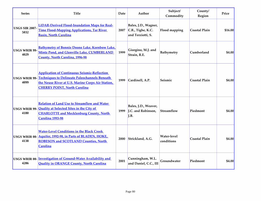
Series Title Date AuthorSubject/
Commodity
County/
RegionPrice
USGS SIR 2007-
5032
LiDAR-Derived Flood-Inundation Maps for Real-
Time Flood-Mapping Applications, Tar River
Basin, North Carolina
2007
Bales, J.D., Wagner,
C.R., Tighe, K.C.
and Terziotti, S.
Flood mapping Coastal Plain $16.00
USGS WRIR 99-
4029
Bathymetry of Bonnie Doone Lake, Kornbow Lake,
Mintz Pond, and Glenville Lake, CUMBERLAND
County, North Carolina, 1996-98
1999Giorgino, M.J. and
Strain, R.E.Bathymetry Cumberland $4.00
USGS WRIR 99-
4099
Application of Continuous Seismic-Reflection
Techniques to Delineate Paleochannels Beneath
the Neuse River at U.S. Marine Corps Air Station,
CHERRY POINT, North Carolina
1999 Cardinell, A.P. Seismic Coastal Plain $4.00
USGS WRIR 99-
4180
Relation of Land Use to Streamflow and Water
Quality at Selected Sites in the City of
CHARLOTTE and Mecklenburg County, North
Carolina 1993-98
1999
Bales, J.D., Weaver,
J.C. and Robinson,
J.B.
Streamflow Piedmont $4.00
USGS WRIR 00-
4138
Water-Level Conditions in the Black Creek
Aquifer, 1992-98, in Parts of BLADEN, HOKE,
ROBESON and SCOTLAND Counties, North
Carolina
2000 Strickland, A.G.Water-level
conditionsCoastal Plain $4.00
USGS WRIR 00-
4286
Investigation of Ground-Water Availability and
Quality in ORANGE County, North Carolina2001
Cunningham, W.L.
and Daniel, C.C., IIIGroundwater Piedmont $4.00
Page 80

Series Title Date AuthorSubject/
Commodity
County/
RegionPrice
USGS WRIR 01-
4094
Low-Flow Characteristics and Discharge Profiles
for Selected Streams in the Cape Fear River Basin,
North Carolina, through 1998
2001Weaver, J.C. and
Pope, B.F.
Water-level
conditionsCoastal Plain $4.00
USGS WRIR 01-
4097
Hydrologic and Salinity Characteristics of
Currituck Sound and Selected Tributaries in North
Carolina and Virginia, 1998-99
2001 Caldwell, W.S.Water-level
conditionsCoastal Plain $4.00
USGS WRIR 01-
4138
Mountain Island Lake, North Carolina: Analysis
of Ambient Conditions and Simulation of
Hydrodynamics, Constituent Transport, and Water-
Quality Characteristics, 1996-97
2001
Bales, J.D., Sarver,
K.M. and Giorgino,
M.J.
Hydrologic
InvestigationsPiedmont $4.00
USGS WRIR 02-
4105
Preliminary Hydrogeologic Assessment and Study
Plan for a Regional Ground-Water Resource
Investigation of the Blue Ridge and Piedmont
Provinces of North Carolina
2002Daniel, C.C., III and
Dahlen, P.R.
Hydrologic
Investigations
Blue Ridge and
Piedmont$4.00
USGS WSP 1873-
E
Movement and Dispersion of Soluble Pollutants in
the Northeast Cape Fear Estuary, North Carolina1972
Hubbard, E.F. and
Stamper, W.G.Pollutants Coastal Plain $2.00
Volume ICorundum and the Peridotites of Western North
Carolina1905
Pratt, J.H. and
Lewis, J.V.
Corundum,
peridotites
Blue Ridge,
PiedmontOP
Volume II The Fishes of North Carolina 1907 Smith, H.M. Fishes State-wide OP
Page 81

Series Title Date AuthorSubject/
Commodity
County/
RegionPrice
Volume III Parts 1 and 2 The Coastal Plain of North Carolina 1912
Clark, W.B., Miller,
B.L., Stephenson,
L.W., Johnson, B.L.
and Parker, H.N.
Stratigraphy Coastal Plain OP
Volume V The Cretaceous Formations of North Carolina 1923Stephenson, L.W.
and Rathbun, M.J.
Cretaceous
formationsCoastal Plain OP
1958 State Geologic Map 1958N C Geological
SurveyGeologic map State-wide $5.00
A Digital Shaded-Relief Portrayal of the United
States (poster, 35"x52")1991
Thelin, G.P. and
Pike, R.J.
National
TopographyUnited States $12.00
A Tapestry of Time and TerrainVigil, J.F., Pike, R.J.
and Howell, D.G.Bedrock geology United States $9.00
An Oceanographic Atlas of the Carolina Continental
Margin1971
Newton, J.G., Pilkey,
O.H. and Blanton,
J.O.
AtlasContinental
marginOP
Appendix to the Report of the Geological Survey of
North Carolina, 1873; Being a Brief Abstract of that
Report and A General Description of the State,
Geographical, Geological, Climactic and
Agricultural
1873 Kerr, W.C. General geology State-wide OP
Page 82

Series Title Date AuthorSubject/
Commodity
County/
RegionPrice
Biennial Report of the State Geologist 1893-1894 1894North Carolina
Geological SurveyGeneral geology State-wide OP
Biennial Report of the State Geologist 1895-1896 1896 Holmes, J.A. General geology State-wide OP
Biennial Report of the State Geologist 1897-1898 1898 Holmes, J.A. General geology State-wide OP
Biennial Report of the State Geologist 1901-1902 1902 Holmes, J.A. General geology State-wide OP
Biennial Report of the State Geologist 1905-1906 1907 Pratt, J.H. General geology State-wide OP
Biennial Report of the State Geologist 1907-1908 1908 Pratt, J.H. General geology State-wide OP
Building Stones of North Carolina 1983 Carpenter, P.A., III Building stone State-wide OP
Bulletin 90 Supplement - Discussion of Geol Non-
suitutability of U S DOE's SE-5 area for Disposal
of High-level Radioactive Waste
1988Merschat, C.E. and
Wiener, L.S.
Blue Ridge,
radioactive waste
Buncombe,
Haywood,
Madison
$3.00
Bulletin 95 map on poster paper 1993Lawrence, D.P. and
Hoffman, C.W.Geologic map Coastal Plain $6.00
Crystal Coast, North Carolina Satellite Image Map Thomas, J-C. Satellite image Crystal Coast $10.00
Drowning the North Carolina Coast: Sea-level Rise
and Estuarine Dynamics2003
Riggs, S.R. and
Ames, D.V.Erosion Coastal Plain OP
Page 83
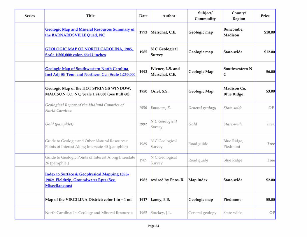
Series Title Date AuthorSubject/
Commodity
County/
RegionPrice
Geologic Map and Mineral Resources Summary of
the BARNARDSVILLE Quad, NC1993 Merschat, C.E. Geologic map
Buncombe,
Madison$10.00
GEOLOGIC MAP OF NORTH CAROLINA, 1985,
Scale 1:500,000; color, 66x44 inches1985
N C Geological
SurveyGeologic map State-wide $12.00
Geologic Map of Southwestern North Carolina
Incl Adj SE Tenn and Northern Ga ; Scale 1:250,0001992
Wiener, L.S. and
Merschat, C.E.Geologic Map
Southwestern N
C$6.00
Geologic Map of the HOT SPRINGS WINDOW,
MADISON CO, NC; Scale 1:24,000 (See Bull 60) 1950 Oriel, S.S. Geologic Map
Madison Co,
Blue Ridge$3.00
Geological Report of the Midland Counties of
North Carolina1856 Emmons, E. General geology State-wide OP
Gold (pamphlet) 1992N C Geological
SurveyGold State-wide Free
Guide to Geologic and Other Natural Resources:
Points of Interest Along Interstate 40 (pamphlet)1989
N C Geological
SurveyRoad guide
Blue Ridge,
PiedmontFree
Guide to Geologic Points of Interest Along Interstate
26 (pamphlet)1989
N C Geological
SurveyRoad guide Blue Ridge Free
Index to Surface & Geophysical Mapping 1895-
1982; Fieldtrip, Groundwater Rpts (See
Miscellaneous)
1982 revised by Enos, R. Map index State-wide $2.00
Map of the VIRGILINA District; color 1 in = 1 mi 1917 Laney, F.B. Geologic map Piedmont $5.00
North Carolina: Its Geology and Mineral Resources 1965 Stuckey, J.L. General geology State-wide OP
Page 84
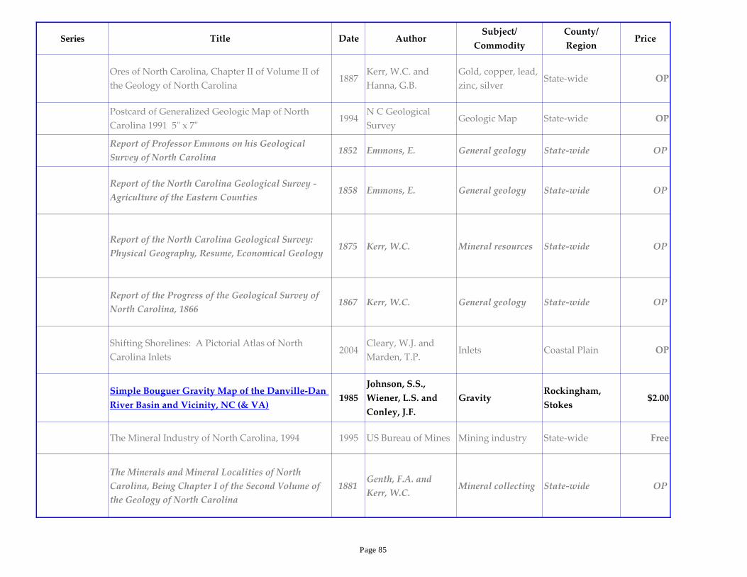
Series Title Date AuthorSubject/
Commodity
County/
RegionPrice
Ores of North Carolina, Chapter II of Volume II of
the Geology of North Carolina1887
Kerr, W.C. and
Hanna, G.B.
Gold, copper, lead,
zinc, silverState-wide OP
Postcard of Generalized Geologic Map of North
Carolina 1991 5" x 7"1994
N C Geological
SurveyGeologic Map State-wide OP
Report of Professor Emmons on his Geological
Survey of North Carolina1852 Emmons, E. General geology State-wide OP
Report of the North Carolina Geological Survey -
Agriculture of the Eastern Counties1858 Emmons, E. General geology State-wide OP
Report of the North Carolina Geological Survey:
Physical Geography, Resume, Economical Geology1875 Kerr, W.C. Mineral resources State-wide OP
Report of the Progress of the Geological Survey of
North Carolina, 18661867 Kerr, W.C. General geology State-wide OP
Shifting Shorelines: A Pictorial Atlas of North
Carolina Inlets2004
Cleary, W.J. and
Marden, T.P.Inlets Coastal Plain OP
Simple Bouguer Gravity Map of the Danville-Dan
River Basin and Vicinity, NC (& VA)1985
Johnson, S.S.,
Wiener, L.S. and
Conley, J.F.
GravityRockingham,
Stokes$2.00
The Mineral Industry of North Carolina, 1994 1995 US Bureau of Mines Mining industry State-wide Free
The Minerals and Mineral Localities of North
Carolina, Being Chapter I of the Second Volume of
the Geology of North Carolina
1881Genth, F.A. and
Kerr, W.C.Mineral collecting State-wide OP
Page 85

Series Title Date AuthorSubject/
Commodity
County/
RegionPrice
This Dynamic Earth: The Story of Plate Tectonics 1996Kious, W.J. and
Tilling, R.I.Plate tectonics World-wide $7.00
This Dynamic Planet poster
Simkin, T., Tilling,
R.I., Vogt, P.R.,
Kirby, S.H.,
Kimberly, P. and
Stewart, D.B.
Geologic hazards World-wide $14.00
Page 86