Norfolk health, heritage and biodiversity walks · Norfolk health, heritage and biodiversity walks....
31
Weavers Way Peterson’s Lane Cromer Road Heydon Road Holman Road Blickling Road Abel Heath Dismantled Railway Start Norfolk County Council at your service Aylsham Reepham • Buxton • Blickling • Cawston • Marsham Norfolk health, heritage and biodiversity walks
Transcript of Norfolk health, heritage and biodiversity walks · Norfolk health, heritage and biodiversity walks....

Weavers Way Peterson’s Lane
Cromer Road
Heydon Road
Holman Road
Blickling Road
Abel Heath
Disman
tled
Railway
Start
Norfolk County Council at your service
Aylsham Reepham • Buxton • Blickling • Cawston • Marsham
Norfolk health, heritage and biodiversity walks

Contents
Introduction page 2
Walk 1 Aylsham: starter walks page 6
Walk 2 Aylsham: Weavers’ Way and Drabblegate page 10
Walk 3 Aylsham: Marriott’s Way and Green Lane page 14
Walk 4 Aylsham: Abel Heath and Silvergate page 18
Walk 5 Aylsham town walk page 22
Walk 6 Blickling via Moorgate page 26
Walk 7 Marsham via Fengate page 30
Walk 8 Cawston via Marriott’s Way page 34
Walk 9 Reepham; Marriott’s Way and Catchback Lane page 38
Walk 10 Reepham via Salle Church page 42
Walk 11 Buxton via Brampton page 46
Walk 12 Buxton via Little Hautbois page 50
Further information page 56
1
No
rfolk
Co
un
ty Council – Health • Heritage • Biodivers
ity
N
orfolk Walk
s

32
Introduction
Contact with natural surroundings offers a restorative environment which enables you to relax, unwind and re-charge your
batteries helping to enhance your mood and reduce stress levels.
Regular exercise can help to prevent major conditions, such as coronary heart disease, type II diabetes, high blood pressure, strokes, obesity, osteoporosis, osteoarthritis, bowel cancer and back pain.
Moderate physical activity such as regular walking in natural surroundings is a simple and enjoyable way of keeping fit. To gain maximum benefit, aim to walk at a pace where your heart beats a little faster, your breathing becomes a little heavier and you feel a little warmer.
These circular walks have been carefully designed to encourage you to explore the local countryside, discover urban green spaces and to enjoy the heritage of Norfolk, both natural and man made. The routes explore Aylsham and local surrounding villages.
Aylsham is a beautiful market town with the streets still arranged on the original medieval layout. Find out more by pausing to read the information panels dotted around the town.
The River Bure is a feature of several of the walks. Four disused mills on the river can be seen, the most outstanding being the beautifully restored Buxton Mill. Navigation on the River Bure was extended in 1779 by building five locks between Aylsham and Coltishall allowing wherries to bring trade to Aylsham. In August 1912 however, a devastating flood destroyed the locks. They were not rebuilt, and the railway station a few hundred yards from Aylsham Mill took over much of the river traffic.
Three railway lines once converged in Aylsham and these walks make good use of Marriott’s Way, Bure Valley Way and Weavers’ Way; long distance trails based on these old rail routes. The disused railway lines now also provide excellent wildlife corridors, bringing wildlife right into the town.
On these walks you will be able to see many aspects of the rich and varied biodiversity Norfolk has to offer. The Norfolk Biodiversity Partnership aims to conserve, enhance and restore the county’s biological diversity.
More details can be found at www.norfolkbiodiversity.org
Walk informationInformation about the walks includes details such as the start point, distance, path surface (soft surfaces include natural surfaces found on field footpaths, farm tracks, meadows, woods, etc), gradients and facilities available. The following symbols will help you to decide if the walk is suitable for you.
Getting aroundAylsham and most of the villages featured in this guide can be reached by public transport, so why not leave the car behind? The Bure Valley Railway offers an interesting alternative for the Aylsham and Buxton walks.
For bus details, contact Traveline on 0871 200 2233 (calls •cost 10p per minute plus network extras) or visit www.travelineeastanglia.co.uk
For the steam train, contact Bure Valley Railway on •01263 733858 or visit www.bvrw.co.uk
Tread lightly and safelyPlease respect natural habitats as you walk; stay on the footpaths and take any litter home. Some of the walks take you through meadows where traditional grazing takes place; please keep dogs on a lead and shut gates behind you.
According to the season you may encounter muddy conditions or long vegetation – dress accordingly, remember there is no such thing as bad weather, just inappropriate clothing! Be safe and plan ahead.
Some of the walks include sections of Permissive Path. They have been created as part of Defra’s Countryside Stewardship Scheme and are managed by Natural England; they are not permanent public footpaths but are available for you to enjoy by permission of the land owners. To check availability see the Defra map boards beside these paths.
Other walking opportunities are shown on the Defra website: http://countrywalks.defra.gov.uk
54
If you have not exercised for a while, it is better to start with the shorter routes, before moving on to the more challenging walks. The variety of walks allows you to build up your physical activity levels gently.
Information Start point Market Place • Grid Reference TG192269 Parking Any town centre free car park Distance 3 miles Details Moderate gradient, 20% soft
Steps
Stile
Buggy/ Wheelchair Suitable for buggies/wheelchairs
Cow Cattle could be grazing in some meadows
Boot The route could contain muddy/uneven sections and stout shoes or boots are recommended
Tea cup Café nearby
Beer mug Public house nearby
Toilets nearby

76
Get walking... with two easy Bure Valley and Marriott’s Way starter walks
Walk
1
Information Start point Bure Valley Railway, Station Road, Aylsham • Grid Reference TG196265 Parking Bure Valley Railway car park Distance 1 mile (*longer walk 2.5 miles) Details 80% firm, minor gradient
Walk instructionsFrom Bure Valley Railway Station, walk through the car park to start the walk at the Bure Valley Way sign. Follow the footpath beside the railway track to the road.
Go through the gate and turn right, walk beside the A140 for a few paces and turn right into Bure Valley Lane. Follow the road initially left, then bearing right to continue up Buxton Road.
*For the short walk, at the T junction at the top of the hill, turn right onto Norwich Road and immediately right into Station Road.
For the longer walk, before reaching the end of Buxton Road, turn left onto a tarmac footpath between the house numbers 20 and 16 (just before the ‘give way’ sign), and continue ahead onto Clover Road. Turn right at the T-junction into Copeman Road.
Turn left at the next T-junction into Norwich Road; cross the road at the bus stop and take the tarmac footpath opposite the bus stop into Crompton Road. Continue ahead along Crompton Road to the end, turning left at the T-junction into Hungate Street.
Just before the Henry Page Road turn right to
follow the tarmac path winding its way through the trees adjacent to the road. Cross Ray Bond Way, Howard Way and turn right into Mileham Drive.
Turn almost immediately right again onto Marriott’s Way. Follow Marriott’s Way to the end, cross Norwich Road and return to the start.
● Why not use the steam train to take you to one of the stations and walk back along Bure Valley Way? For more information on the trains, contact 01263 733858 or look on the Bure Valley Way website: www.bvrw.co.uk

Bure Valley and Marriott’s Way starter walks
Walk
1
98
Start with an easy one mile walk or extend it to two and a half miles using a tree lined footpath to Marriott’s Way, an ideal introduction before tackling the more adventurous walks.
Bure Valley
Lane
Buxton Road
Motel
Station Road
Clover Road
Copeman Road
Crompton Road
Hungate
Street
A140
B1145
Norw
ich Road
Start
This map is based upon Ordnance Survey material with the permission of Ordnance Survey on behalf of the Controller of Her Majesty’s Stationery Office © Crown copyright. Unauthorised reproduction infringes Crown copyright and may lead to prosecution or civil proceedings. Norfolk County Council. Licence No: 100019340. 2008.
● The wild flowers, shrubs and brambles growing alongside the disused railways help provide an important habitat for common birds such as the humble house sparrow, unfortunately now in decline.
● The Bure Valley Railway was built on the track bed of the old Midland and Great Northern Railway which closed during the 1950’s. It was locally known as the “Muddle and Go Nowhere” Railway. Broadland District Council acquired the Aylsham to Wroxham section in 1987 and converted half its width to create a nine mile walking and cycling route, The Bure Valley Way.
Aylsham
P
Marriott’s Way
Walk 1Optional longer walkParking
Key
0 ½km
¼mile
P
1110
Aylsham: Weavers’ Way and Drabblegate
Walk
2
Information Start point Aylsham Market Place • Grid Reference TG192269 Parking Any town centre free car park Distance 3.1 miles (*or 1.9 miles for shorter walk) Details Moderate gradient, 20% soft
Walk instructionsWalk towards the church from the Market Place. Follow the right hand path around the church and leave via the lych-gate into Cromer Road. Walk down Cromer Road and take the last right turn into The Meadows.
As this quiet lane bears right, go through the kissing gate on the left into the meadow, walk across the field to the exit gate in the opposite corner.
Turn right into Weavers’ Way and walk along the disused railway line to the car park.
*For the short walk, on leaving the car park turn left, and left again over the railway bridge into Millgate, and follow the instructions from Millgate below.
On leaving the car park, turn right and after a few metres left into Banningham Road. Continue along Banningham Road, winding around for half a mile, turning left at the junction beside the “no through road” sign to walk down towards Abbot’s Hall.
Turn left at the T-junction into Drabblegate and continue along Drabblegate for half a mile with glimpses of the River Bure through the meadows on the right. As the road bears left, keep right to walk over the old railway bridge into Millgate.
Turn right into Millgate; walk up the hill towards the town, cross the two
bridges, making use of the pavement where available before continuing ahead as Millgate becomes Gas Hill.
As the road bears right near the top of the hill, turn left into Oakfield Road opposite the Roman Catholic church.
Turn first right into Blofields Loke; at the end of the Loke turn right then immediately left to return to the Market Place.
● The River Bure starts as a small stream near Melton Constable before winding its way through the countryside via Aylsham, Wroxham and the Broads, reaching the sea at Great Yarmouth.
● From the road in Drabblegate, pause to look across the river. Lush and dense vegetation beside the river provides cover for resting birds and small mammals, whilst the meadows support a wide diversity of herbal flora. The meadows on the far side have gained County Wildlife Site status - areas of land rich in wildlife: a tract of heath, a copse, a village pond or a meadow.
Aylsham: Weavers’ Way and Drabblegate
Walk
2
1312
● There is a memorial to the landscape gardener Humphry Repton on St. Michael and All Angels Church.
A pleasant, easy route out of Aylsham via Weavers’ Way, crossing the River Bure in couple of places and walking through historic Millgate.
Walk 2Parking
Key
0 ½km
¼mile
P
Gas
hous
e H
ill
Mill
gate
A140
Drab
bleg
ate
Banningham
Road
Cromer
Road
Weavers Way
(disused railway)
Start
This map is based upon Ordnance Survey material with the permission of Ordnance Survey on behalf of the Controller of Her Majesty’s Stationery Office © Crown copyright. Unauthorised reproduction infringes Crown copyright and may lead to prosecution or civil proceedings. Norfolk County Council. Licence No: 100019340. 2008.
P
P
1514
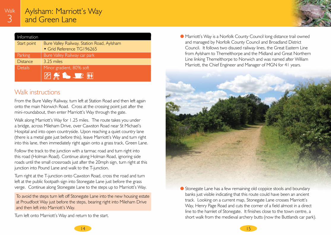
Aylsham: Marriott’s Way and Green Lane
Walk
3
Information Start point Bure Valley Railway, Station Road, Aylsham • Grid Reference TG196265 Parking Bure Valley Railway car park Distance 3.25 miles Details Minor gradient, 80% soft
Walk instructionsFrom the Bure Valley Railway, turn left at Station Road and then left again onto the main Norwich Road. Cross at the crossing point just after the mini-roundabout, then enter Marriott’s Way through the gate.
Walk along Marriott’s Way for 1.25 miles. The route takes you under a bridge, across Mileham Drive, over Cawston Road near St Michael’s Hospital and into open countryside. Upon reaching a quiet country lane (there is a metal gate just before this), leave Marriott’s Way and turn right into this lane, then immediately right again onto a grass track, Green Lane.
Follow the track to the junction with a tarmac road and turn right into this road (Holman Road). Continue along Holman Road, ignoring side roads until the small crossroads just after the 20mph sign, turn right at this junction into Pound Lane and walk to the T-junction.
Turn right at the T-junction onto Cawston Road, cross the road and turn left at the public footpath sign into Stonegate Lane just before the grass verge. Continue along Stonegate Lane to the steps up to Marriott’s Way.
To avoid the steps turn left off Stonegate Lane into the new housing estate at Proudfoot Way just before the steps, bearing right into Mileham Drive and then left into Marriott’s Way.
Turn left onto Marriott’s Way and return to the start.
● Marriott’s Way is a Norfolk County Council long distance trail owned and managed by Norfolk County Council and Broadland District Council. It follows two disused railway lines, the Great Eastern Line from Aylsham to Themelthorpe and the Midland and Great Northern Line linking Themelthorpe to Norwich and was named after William Marriott, the Chief Engineer and Manager of MGN for 41 years.
● Stonegate Lane has a few remaining old coppice stools and boundary banks just visible indicating that this route could have been an ancient track. Looking on a current map, Stonegate Lane crosses Marriott’s Way, Henry Page Road and cuts the corner of a field almost in a direct line to the hamlet of Stonegate. It finishes close to the town centre, a short walk from the medieval archery butts (now the Buttlands car park).
Marriott’s Way
Aylsham: Marriott’s Way and Green Lane
Walk
3
1716
An ideal walk for a leg stretch out along Marriott’s Way before returning along Green Lane, one of several old routes radiating out from the town.
This map is based upon Ordnance Survey material with the permission of Ordnance Survey on behalf of the Controller of Her Majesty’s Stationery Office © Crown copyright. Unauthorised reproduction infringes Crown copyright and may lead to prosecution or civil proceedings. Norfolk County Council. Licence No: 100019340. 2008.
Walk 3Parking
Key
0 ½km
¼mile
P
PStart
Holman Road
Pound Lane
Ston
egat
e La
neM
ileha
m
Driv
e
Cawston
RoadGreen Lane
Woodgate Crossing
Station Road
Nor
wic
h Ro
ad
St Michael’s Hospital

18
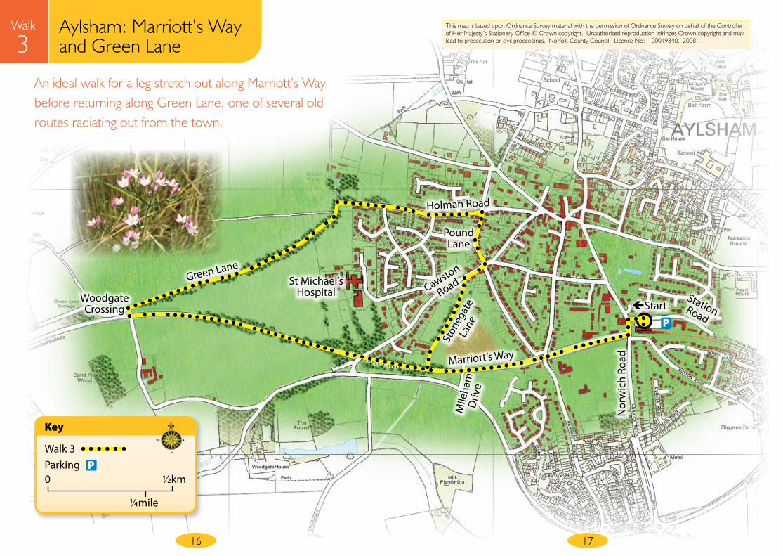
Aylsham: Abel Heath and Silvergate
Walk
4
Information Start point Aylsham Market Place • Grid Reference TG192269 Parking Any town centre free car park Distance 3.1 miles Details Moderate gradient, 35% soft surface
Walk instructionsLeave the Market Place via Penfold Street (between the Black Boys and the Post Office). Turn left at the thatched John Soame water pump, then right into Holman Road (beside the fire station).
At the end of Holman Road, keep right following the track as it bears left, ignoring the white gates on the right. Turn left into Heydon Road at the end of this track.
Keep right at the Abel Heath junction, following signs to Blickling.
After passing Abel Heath Farm on the right and walking towards Silvergate, turn right onto Weavers’ Way (look out for the Weavers’ Way sign post behind the barn on the right with the red post box and black parish notice board set in the wall – also opposite the triangular left turn road sign).
Follow the Weavers’ Way field edge path up the hill keeping the hedge on the right and ignoring all other paths. Walk through the kissing gate into a meadow bounded by large oak trees and continue down the hill to the road.
Just before reaching the road, go through the gate on the right, through a second gate and turn right to walk along a path parallel to the Blickling Road. Cross Blickling Road and continue along Peterson’s Lane opposite.
At the T-junction, turn right into the Cromer Road, and walk up the hill and steps into the churchyard, take the left hand path around the church which leads into the Market Place.
19
● The thatched well is a memorial to John Soame. At 170 feet deep, it was dug in 1911 for the benefit of the residents of Aylsham to ensure reliable water quality.
● The streets in Aylsham town centre follow the medieval pattern, although the buildings have since been updated. The open space in the Market Place now belongs to the National Trust as part of the Blickling estate and still looks much as it did in the early 19th Century.
● There has been a public house known as “The Black Boys” since 1659 on the corner of the Market Place. Horatio Nelson is reputed to have danced here in 1814 at the end of the Napoleonic Wars.
● The Anglo Saxon name for Aylsham translates as Aegel’s homestead. Aylsham was an important town recorded in Domesday Book with approximately 1,000 residents.
Aylsham: Abel Heath and Silvergate
Walk
4
20
Enjoy a rural walk out of Aylsham, using a mix of field edge footpaths, cattle grazed meadows and quiet country lanes
Walk 4Parking
Key
0 ½km
¼mile
P
21
This map is based upon Ordnance Survey material with the permission of Ordnance Survey on behalf of the Controller of Her Majesty’s Stationery Office © Crown copyright. Unauthorised reproduction infringes Crown copyright and may lead to prosecution or civil proceedings. Norfolk County Council. Licence No: 100019340. 2008.
Weavers’ Way
Peterson’s Lane
Cromer Road
Heydon Road
Holman Road
Blickling Road
Abel Heath
Abel Heath Farm
Dismantled
Railway
Permissive Path
Silvergate
Start
P

22
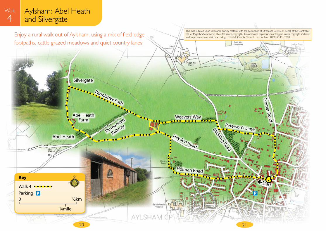
Aylsham town walk
Walk
5
23
Information Start point Bure Valley Railway, Station Road, Aylsham • Grid Reference TG196265 Parking Bure Valley Railway car park Distance 4.1 miles Details Moderate gradient, 5% soft
Walk instructionsFrom Bure Valley Railway Station, walk through the car park to start the walk at the Bure Valley Way sign. Follow the footpath beside the railway track to the road; walk through the gate and turn right, walk alongside the A140 for a few paces, and turn right again into the Bure Valley Lane. Follow the road initially left, then bearing right to continue up Buxton Road.
Before reaching the top, turn left onto a tarmac path between the house numbers 20 and 16 and just before the ‘give way’ sign, and continue ahead onto Clover Road.
Turn right at the T-junction into Copeman Road
Turn left at the next T-junction into Norwich Road; cross the road at the bus stop and take the tarmac path opposite the bus stop. Continue right along Crompton Road, turning left at the T-junction into Hungate Street.
Just before the Henry Page Road turn right to follow the tarmac pavement winding its way through the trees and ignore all other paths. Cross Ray Bond Way and Howard Way before turning right into Mileham Drive.
Then immediately bear left onto Marriott’s Way, and after a very short distance, walk down the steps on the right into Stonegate Lane.
To avoid the steps, turn right at Mileham Drive, cross Marriott’s Way, bear left into Proudfood Way and then right into Stonegate Lane.
Stay on the path, turning right at the end on to the B1145, cross the road and take the first left into Pound Lane, walking straight ahead at the cross roads into Sandy Lane.
Turn right into Heydon Road, cross Blickling Road into Rawlinsons Lane opposite the junction. Turn right at the T-junction into Peterson’s Lane, and at the next T-junction turn left into Cromer Road.
Take the second right turn into The Meadows and follow this to the end, continuing along the narrow footpath when the road finishes. Turn right into Millgate and walk up the hill using the pavements where available.
Turn left on the corner at the top of the hill into Oakfield Road (just before White Hart Street). Turn left at the T-junction into Burgh Road; cross the road after a short distance and take the first tarmac path on the right (just after the trees)
Continue into Parmeter Close, keeping right into another path as the road bears left.
Cross the road and continue ahead into Wrench Close, and bear right into another path (almost hidden between numbers 14 and 12). Turn left at the Norwich Road and return to the start.
Aylsham town walk
Walk
5
24
An interesting town walk linking the new with the old, following recently created tree lined paths beside open green spaces plus attractive lanes and footpaths around the older areas of the town.
Walk 5Parking
Key
0 ½km
¼mile
P
25
This map is based upon Ordnance Survey material with the permission of Ordnance Survey on behalf of the Controller of Her Majesty’s Stationery Office © Crown copyright. Unauthorised reproduction infringes Crown copyright and may lead to prosecution or civil proceedings. Norfolk County Council. Licence No: 100019340. 2008.
Pound Lane
Sandy Lane
Cromer Road
The
M
eado
ws
Mill
gate
Oak
field
Ro
ad
Peterson’s Lane
Raw
linso
ns
Lane
Station Road
Burgh RoadParmeter Close
Wrench Close
Heydon Road
Mile
ham
D
rive
● A mill at Aylsham is mentioned in the 1086 Domesday Book. Development of the area continued over the centuries, with Millgate becoming a hub of industrial activity particularly once the Aylsham Navigation was opened. British Oil & Cake Mills were the last millers, leaving the mill in 1967.
Bure Valley
Lane
Clover Road
Norw
ich Road
Copeman
Road
Crompton
Road
Hungate
Street
A140
B1145
Aylsham
Marriott’s Way
StartSton
egat
e La
ne
P
26
Blickling via Moorgate
Walk
6
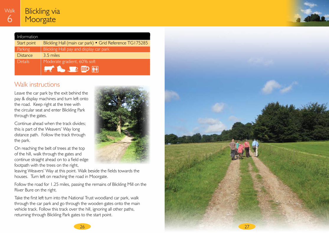
Information Start point Blickling Hall (main car park) • Grid Reference TG175285 Parking Blickling Hall pay and display car park Distance 3.5 miles Details Moderate gradient, 60% soft
Walk instructionsLeave the car park by the exit behind the pay & display machines and turn left onto the road. Keep right at the tree with the circular seat and enter Blickling Park through the gates.
Continue ahead when the track divides; this is part of the Weavers’ Way long distance path. Follow the track through the park.
On reaching the belt of trees at the top of the hill, walk through the gates and continue straight ahead on to a field edge footpath with the trees on the right, leaving Weavers’ Way at this point. Walk beside the fields towards the houses. Turn left on reaching the road in Moorgate.
Follow the road for 1.25 miles, passing the remains of Blickling Mill on the River Bure on the right.
Take the first left turn into the National Trust woodland car park, walk through the car park and go through the wooden gates onto the main vehicle track. Follow this track over the hill, ignoring all other paths, returning through Blickling Park gates to the start point.
27

Blickling via Moorgate
Walk
6
28
Enjoy the scenery walking through Blickling Park down to Moorgate, passing the remains of Blickling Mill on the River Bure.
Walk 6Parking
Key
0 ½km
¼mile
P
29
This map is based upon Ordnance Survey material with the permission of Ordnance Survey on behalf of the Controller of Her Majesty’s Stationery Office © Crown copyright. Unauthorised reproduction infringes Crown copyright and may lead to prosecution or civil proceedings. Norfolk County Council. Licence No: 100019340. 2008.
Moorgate
Blickling Park
Blickling
River Bure
Blickling Mill (disused)
B1354
Weavers’ W
ay
● Blickling Mill ceased milling production in 1914, although it continued to pump water to cattle troughs for Blickling Hall until the 1950’s. The top floors were removed when the building became derelict and now the buildings form part of picturesque holiday cottages beside the River Bure.
● Blickling Park is one of 1,300 County Wildlife Sites in Norfolk. The site is mostly parkland, with a large ornamental lake, formal gardens and woods. There are many scattered mature trees in the park, mostly native trees such as oak and beech plus a few sweet chestnut and lime. Several dead trees remain providing important habitats to support a wide variety of different species of insects, bats and birds.
Start
P
P

30
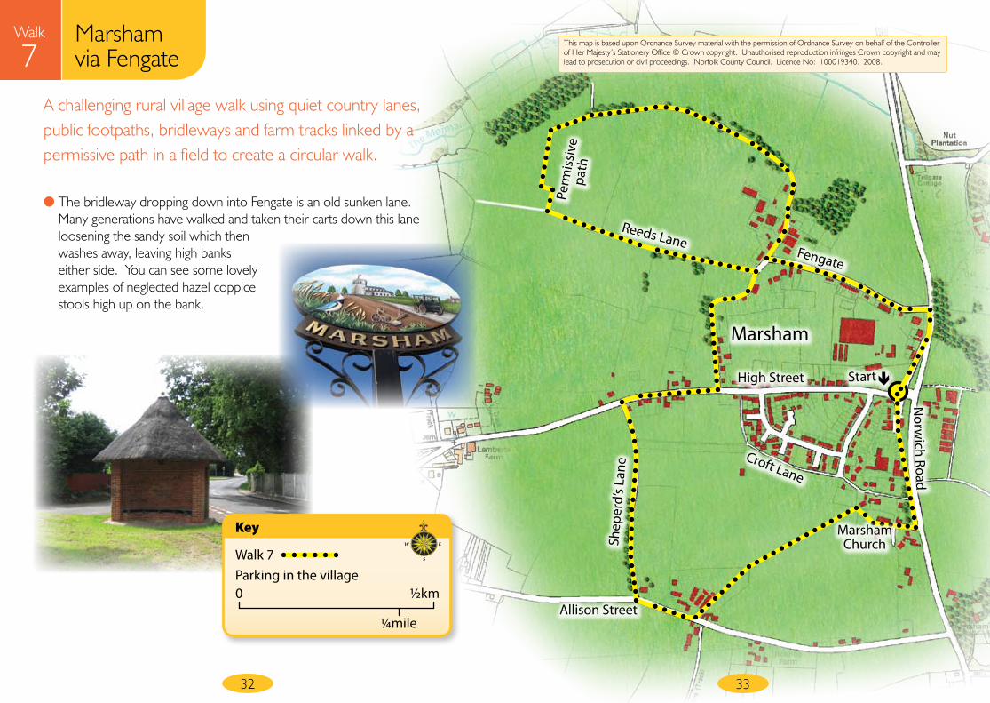
Marsham via Fengate
Walk
7
Information Start point Thatched shelter on Old Norwich Road, Marsham • Grid Reference TG197240 Parking Old Norwich Road Distance 3 miles (*or 2 miles for shorter option) Details Moderate, 85% soft
Walk instructionsFrom the shelter, walk up the Old Norwich Road towards the church, continuing straight ahead onto the Croft Lane footpath.
Turn right into Church Lane; walk up to and through the churchyard, leaving via the brick gateway dated 1864. Bear left to walk across the field; a wooden fingerpost indicates the direction.
Climb the stile at the end and walk clockwise around the meadow towards the buildings.
Turn right at the road and then right again into Shepherd’s Lane, a public bridleway.
Turn right at the end of Shepherd’s Lane onto the High Street.
Turn first left into Cranes Lane and continue along this gravel lane, which becomes a footpath between high banks, down to the road.
*For the short option, turn right and walk down the hill (Fengate). Turn right immediately after The Plough public house and walk along Old Norwich Road to the start point.
For a more challenging walk, at the end of the footpath just before the houses on the left, turn left up a farm track (Reeds Lane). As the track bears left into a field, continue straight ahead on the field edge footpath, keeping the hedge on your right.
31
● All Saints Church at Marsham is 15th Century, built on a late 13th Century plan. In the church is a fine font, with the design of head-dress worn by the ladies dating this to approximately 1467.
Turn right at the brow of the hill: there is a Countryside Stewardship Conservation Walks sign at this point, explaining this short permissive path creates a link between two public rights of way. Follow the permissive path keeping the hedge on your left.
When it reaches the grass track, turn right and walk along this bridleway to the end. Turn left at the road. Turn right after The Plough public house and walk along Old Norwich Road to the start point.
Marsham via Fengate
Walk
7
32
A challenging rural village walk using quiet country lanes, public footpaths, bridleways and farm tracks linked by a permissive path in a field to create a circular walk.
33
This map is based upon Ordnance Survey material with the permission of Ordnance Survey on behalf of the Controller of Her Majesty’s Stationery Office © Crown copyright. Unauthorised reproduction infringes Crown copyright and may lead to prosecution or civil proceedings. Norfolk County Council. Licence No: 100019340. 2008.
Norw
ich Road
Marsham
Allison Street
Perm
issi
ve
path
Shep
erd’
s La
ne
Reeds LaneFengate
High Street
Croft Lane
Walk 7Parking in the village
Key
0 ½km
¼mile
Start
● The bridleway dropping down into Fengate is an old sunken lane. Many generations have walked and taken their carts down this lane loosening the sandy soil which then washes away, leaving high banks either side. You can see some lovely examples of neglected hazel coppice stools high up on the bank.
Marsham Church

34
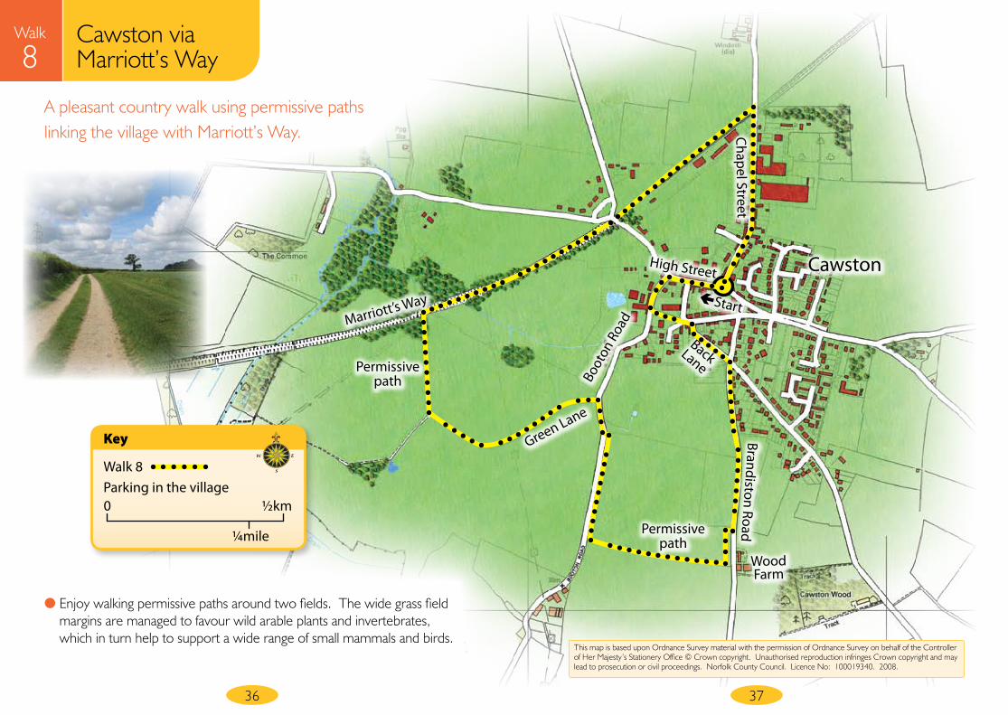
Cawston via Marriott’s Way
Walk
8
Information Start point Cawston Market Place (junction of High Street and Chapel Street) • Grid Reference TG135239 Parking Please park considerately in the village Distance 2.75 miles Details Minor gradient, 60% soft
Walk instructionsFrom the Market Place in the centre of the village, walk towards The Bell public house on the High Street and take the second left turn into Booton Road. Pass the ‘Lucky Strike’ memorial in front of the church before going up the steps and through the gate to walk through the churchyard. Turn right at the end into Back Lane.
Turn right at the give way sign into Brandiston Road.
Just before reaching Wood Farm, turn right into a field then left to follow the wide grassy permissive path keeping the hedge on your left. Walk clockwise around the field, continuing on the grass track adjacent to the road on your left. (Please keep dogs on leads on the permissive paths, thank you.) At the end of this permissive path, turn right into Booton Road, and after a few metres, turn left onto a farm track following the direction of the wooden public footpath fingerpost and another permissive path sign.
Walk along the farm track and as the track bears sharp left, turn right to continue along the grass margin of the field, keeping the hedge on your left. At the end, go up the short bank and turn right onto Marriott’s Way, the disused railway line.
Continue along Marriott’s Way, walking under a bridge up to a wooden five bar gate at the road. Go through the gate and turn right into Chapel Street. Walk along Chapel Street to reach the start point.
35
● A memorial beside the church tells the story of the Lucky Strike, an American bomber which crashed in 1944, narrowly missing the church.
Cawston via Marriott’s Way
Walk
8
36
A pleasant country walk using permissive paths linking the village with Marriott’s Way.
37
This map is based upon Ordnance Survey material with the permission of Ordnance Survey on behalf of the Controller of Her Majesty’s Stationery Office © Crown copyright. Unauthorised reproduction infringes Crown copyright and may lead to prosecution or civil proceedings. Norfolk County Council. Licence No: 100019340. 2008.
High Street Cawston
Boot
on R
oad
Back Lane
Wood Farm
Brandiston RoadChapel Street
Marriott’s Way
Permissivepath
Permissivepath
Green Lane
Walk 8Parking in the village
Key
0 ½km
¼mile
Start
● Enjoy walking permissive paths around two fields. The wide grass field margins are managed to favour wild arable plants and invertebrates, which in turn help to support a wide range of small mammals and birds.
38
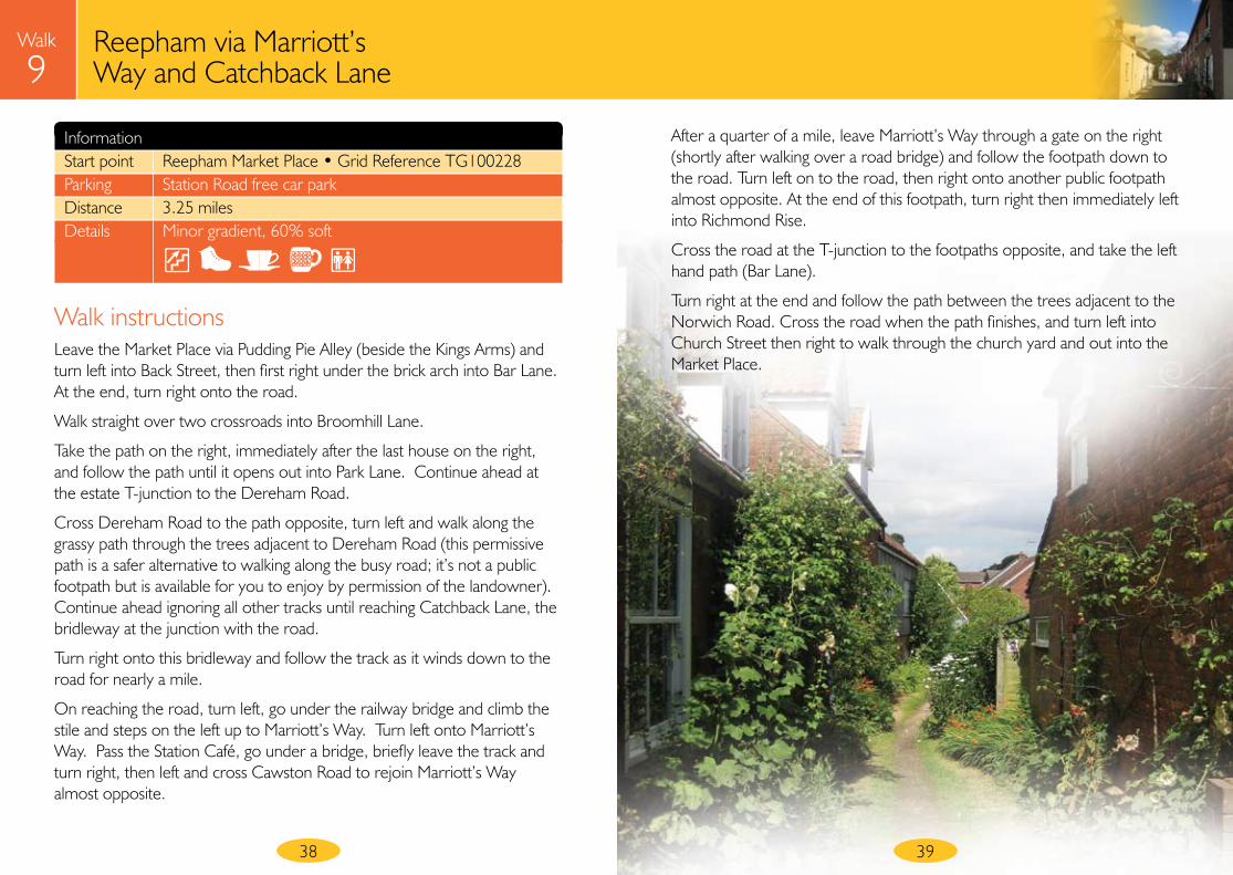
Reepham via Marriott’s Way and Catchback Lane
Walk
9
39
Information Start point Reepham Market Place • Grid Reference TG100228 Parking Station Road free car park Distance 3.25 miles Details Minor gradient, 60% soft
Walk instructionsLeave the Market Place via Pudding Pie Alley (beside the Kings Arms) and turn left into Back Street, then first right under the brick arch into Bar Lane. At the end, turn right onto the road.
Walk straight over two crossroads into Broomhill Lane.
Take the path on the right, immediately after the last house on the right, and follow the path until it opens out into Park Lane. Continue ahead at the estate T-junction to the Dereham Road.
Cross Dereham Road to the path opposite, turn left and walk along the grassy path through the trees adjacent to Dereham Road (this permissive path is a safer alternative to walking along the busy road; it’s not a public footpath but is available for you to enjoy by permission of the landowner). Continue ahead ignoring all other tracks until reaching Catchback Lane, the bridleway at the junction with the road.
Turn right onto this bridleway and follow the track as it winds down to the road for nearly a mile.
On reaching the road, turn left, go under the railway bridge and climb the stile and steps on the left up to Marriott’s Way. Turn left onto Marriott’s Way. Pass the Station Café, go under a bridge, briefly leave the track and turn right, then left and cross Cawston Road to rejoin Marriott’s Way almost opposite.
After a quarter of a mile, leave Marriott’s Way through a gate on the right (shortly after walking over a road bridge) and follow the footpath down to the road. Turn left on to the road, then right onto another public footpath almost opposite. At the end of this footpath, turn right then immediately left into Richmond Rise.
Cross the road at the T-junction to the footpaths opposite, and take the left hand path (Bar Lane).
Turn right at the end and follow the path between the trees adjacent to the Norwich Road. Cross the road when the path finishes, and turn left into Church Street then right to walk through the church yard and out into the Market Place.

Reepham via Marriott’s Way and Catchback Lane
Walk
9
40
An enjoyable walk circling the town via pleasant quiet back streets behind the church and a lovely old country track called Catchback Lane.
41
This map is based upon Ordnance Survey material with the permission of Ordnance Survey on behalf of the Controller of Her Majesty’s Stationery Office © Crown copyright. Unauthorised reproduction infringes Crown copyright and may lead to prosecution or civil proceedings. Norfolk County Council. Licence No: 100019340. 2008.
Reepham
Broomhill Lane
Park
Lan
e
Dereham Road
Catchback Lane
Marriott’s WayCawston Road
Bar L
ane
Bar L
ane
Start Church
Street
Stat
ion
Road
P Norwich Road
Orchard
Lane
Richmond
Rise
● The Reepham town sign shows groups of various items including three churches and was designed by the pupils of Reepham High School. It is based on the myth that three sisters were responsible for building a church each here. However, the medieval churches were built over a span of several generations for the three different parishes which meet in the churchyard. A fragment of Hackford All Saints Church can be found in one corner of the churchyard.
● In 1882, railway stations opened at Reepham and Whitwell. The railway brought cheaper products to the area from larger works elsewhere and it contributed to the downfall of many small local industries thriving in the town at the time.
Walk 9Parking
Key
0 ½km
¼mile
P
Whitwell Street
RuddsLane
42
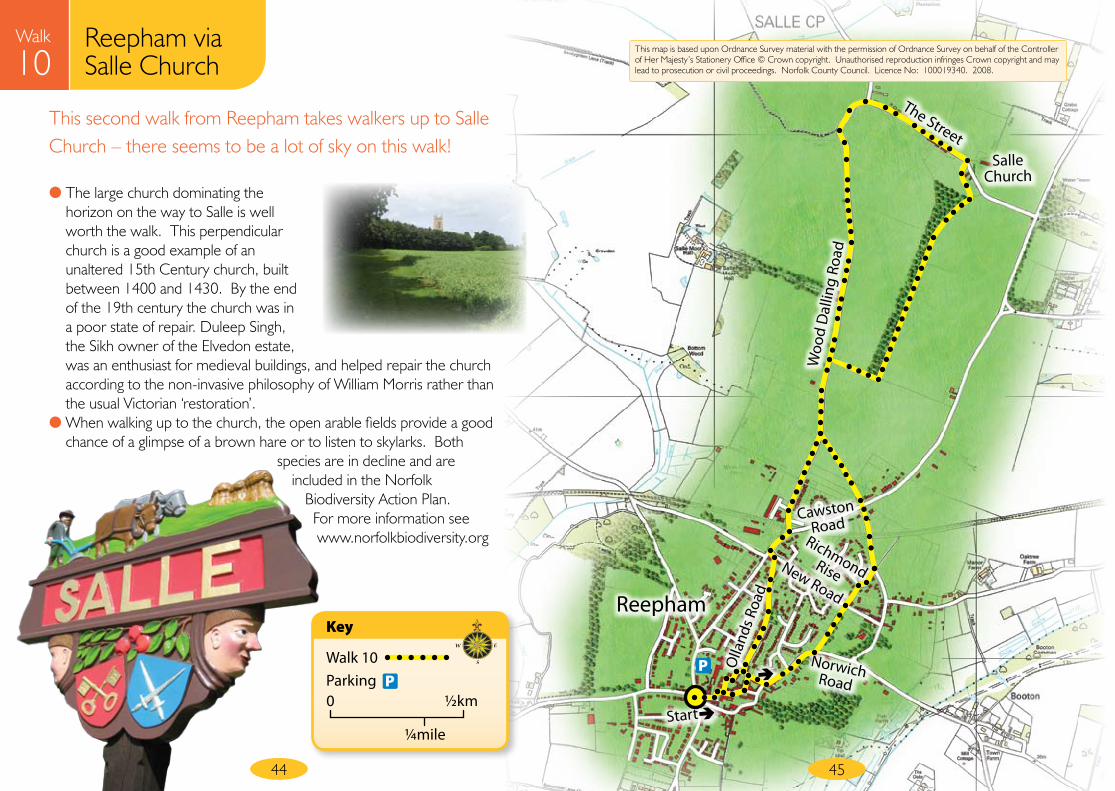
Reepham via Salle Church
Walk
10
Information Start point Reepham Market Place • Grid Reference TG100228 Parking Station Road free car park Distance 3.7 miles Details Minor gradient, 60% soft
Walk instructionsFrom the Market Place, walk towards the church, turning left into St John’s Alley, a hidden narrow alley between Melton House and Ideal Shop/Post Office. At the end cross Ollands Road into Malthouse Yard almost opposite.
Turn left out of Malthouse Yard into Norwich Road and follow the path on the left adjacent to the road, turning left at the end through the wooden barrier into the footpath.
At the end, cross New Road into Richmond Rise, turn first right then bear immediately left through the metal barriers to another footpath. Turn left at the end, walk under the bridge, cross Cawston Road and enter the footpath opposite.
On reaching the road turn right, then immediately right again into a field to follow the field edge footpath on the left adjacent to the road. Bear right at the corner to continue with the hedge on your left until reaching the belt of trees.
Turn left, keeping the trees on your left continue towards Salle Church on the wide grassy path. At the end of the wood, bear left, cross the playing field and turn left onto The Street in front of the church.
At the T-junction, turn left and walk along Wood Dalling Road to Reepham for 1.2 miles. On reaching the busy Cawston Road, turn right, cross the road, then left into Ollands Road. Follow Ollands Road down to Church Road, turn right and walk back to the market place.
43
Reepham via Salle Church
Walk
10
44
This second walk from Reepham takes walkers up to Salle Church – there seems to be a lot of sky on this walk!
45
Reepham
Cawston Road
Norwich Road
New Road
Olla
nds R
oad
Richmond Rise
Start
P
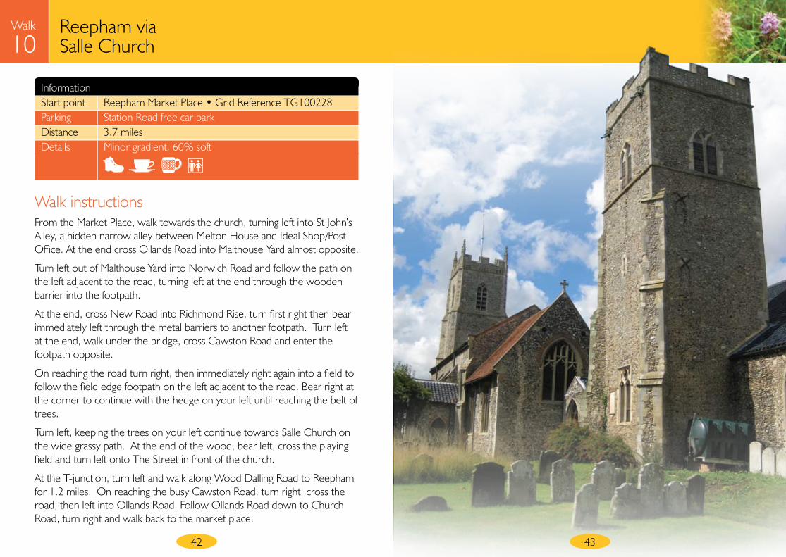
● The large church dominating the horizon on the way to Salle is well worth the walk. This perpendicular church is a good example of an unaltered 15th Century church, built between 1400 and 1430. By the end of the 19th century the church was in a poor state of repair. Duleep Singh, the Sikh owner of the Elvedon estate, was an enthusiast for medieval buildings, and helped repair the church according to the non-invasive philosophy of William Morris rather than the usual Victorian ‘restoration’.
● When walking up to the church, the open arable fields provide a good chance of a glimpse of a brown hare or to listen to skylarks. Both
species are in decline and are included in the Norfolk
Biodiversity Action Plan. For more information see www.norfolkbiodiversity.org
The Street
Woo
d D
allin
g Ro
ad
Salle Church
This map is based upon Ordnance Survey material with the permission of Ordnance Survey on behalf of the Controller of Her Majesty’s Stationery Office © Crown copyright. Unauthorised reproduction infringes Crown copyright and may lead to prosecution or civil proceedings. Norfolk County Council. Licence No: 100019340. 2008.
Walk 10Parking
Key
0 ½km
¼mile
P
46
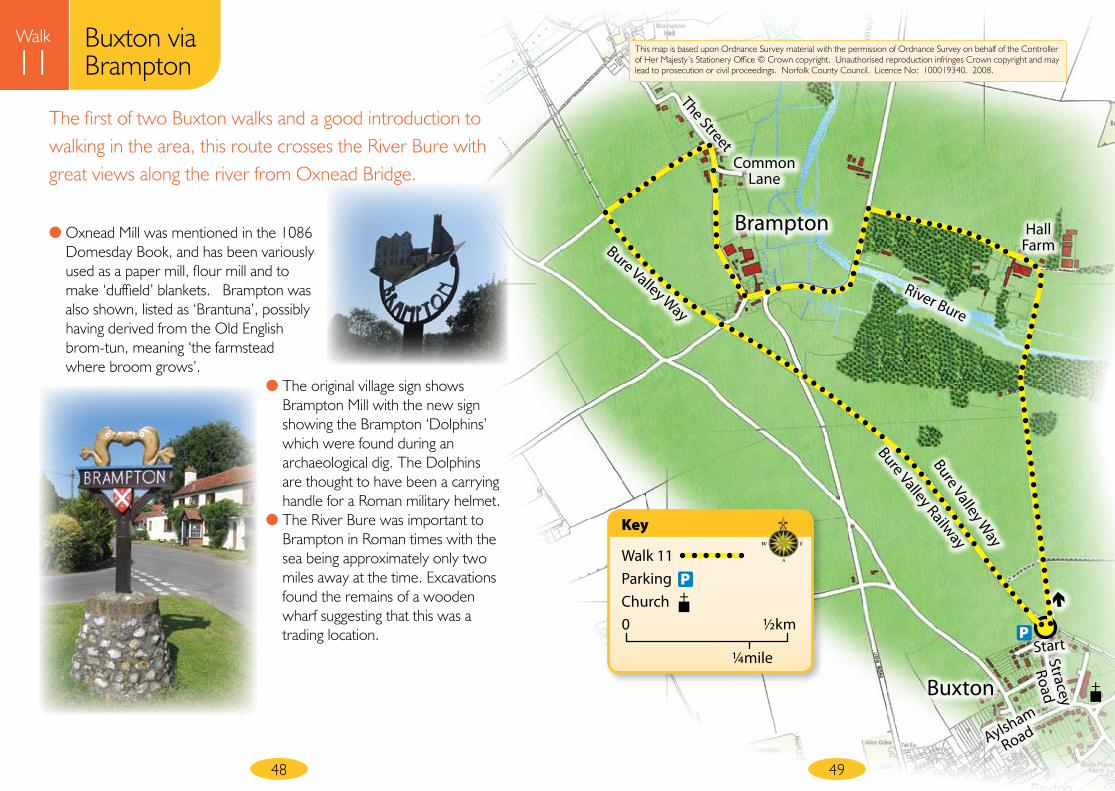
Buxton via Brampton
Walk
11
47
Information Start point Bure Valley Railway Car Park, Stracey Road, Buxton (Stracey Road off Aylsham Road, close to Buxton church. To find the car park, turn right at the T-junction at the far end of Stracey Road, the car park is on the left at the end beside the railway station) • Grid Reference TG232229 Parking Bure Valley Railway Car Park Distance 3.25 miles Details Moderate gradient, 70% soft
Walk instructionsFrom the car park, cross the railway track and the Bure Valley Way, and walk through the wooden chicane opposite into a field. Follow the footpath ahead between the fields.
Walk straight ahead at the top of the hill and continue down the track to a gate, then follow the shingle track over the River Bure and up the hill to the farm.
Turn left at Hall Farm, walk through the busy farmyard and continue along the road.
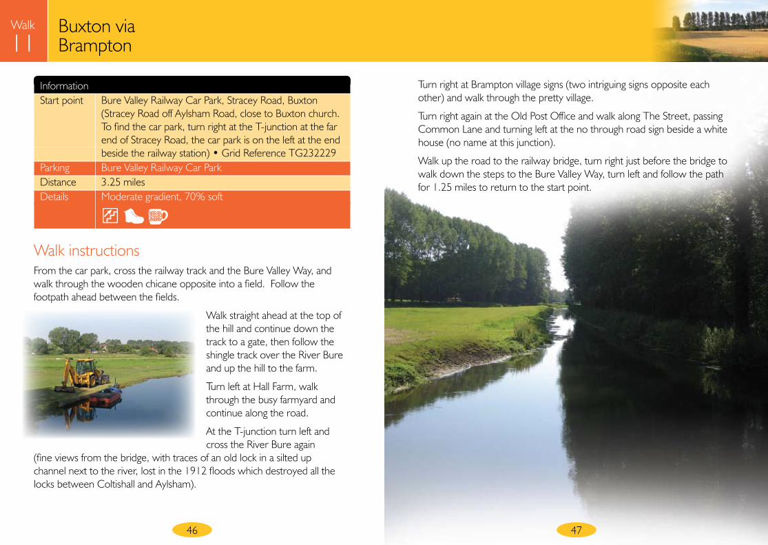
At the T-junction turn left and cross the River Bure again
(fine views from the bridge, with traces of an old lock in a silted up channel next to the river, lost in the 1912 floods which destroyed all the locks between Coltishall and Aylsham).
Turn right at Brampton village signs (two intriguing signs opposite each other) and walk through the pretty village.
Turn right again at the Old Post Office and walk along The Street, passing Common Lane and turning left at the no through road sign beside a white house (no name at this junction).
Walk up the road to the railway bridge, turn right just before the bridge to walk down the steps to the Bure Valley Way, turn left and follow the path for 1.25 miles to return to the start point.
Buxton via Brampton
Walk
11
48
The first of two Buxton walks and a good introduction to walking in the area, this route crosses the River Bure with great views along the river from Oxnead Bridge.
49
Brampton
Buxton
Bure Valley Way
Bure Valley Way
River Bure
Hall Farm
Common Lane
The Street
Bure Valley Railway
Stracey
Road
Aylsham
Road
Start
P
● Oxnead Mill was mentioned in the 1086 Domesday Book, and has been variously used as a paper mill, flour mill and to make ‘duffield’ blankets. Brampton was also shown, listed as ‘Brantuna’, possibly having derived from the Old English brom-tun, meaning ‘the farmstead where broom grows’.
● The original village sign shows Brampton Mill with the new sign showing the Brampton ‘Dolphins’ which were found during an archaeological dig. The Dolphins are thought to have been a carrying handle for a Roman military helmet.
● The River Bure was important to Brampton in Roman times with the sea being approximately only two miles away at the time. Excavations found the remains of a wooden wharf suggesting that this was a trading location.
This map is based upon Ordnance Survey material with the permission of Ordnance Survey on behalf of the Controller of Her Majesty’s Stationery Office © Crown copyright. Unauthorised reproduction infringes Crown copyright and may lead to prosecution or civil proceedings. Norfolk County Council. Licence No: 100019340. 2008.
Walk 11ParkingChurch
Key
0 ½km
¼mile
P
50
Buxton via Little Hautbois
Walk
12
51
Information Start point Bure Valley Railway Car Park, Stracey Road, Buxton • Grid Reference TG232229 Parking Directions as for walk 11 Distance 3.2 miles Details Moderate gradient, 90% soft surface (the low lying meadows beside the river remain waterlogged after periods of rain)
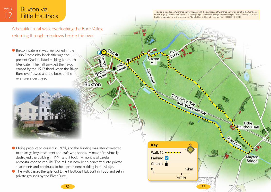
Walk instructionsFrom the car park, cross the rail track and turn right onto the Bure Valley Way path.
Just before the bridge, go down the steps on the left, turning left at the bottom onto Mill Street. Pass Buxton Mill, walk for a short distance on the road winding beside the river, cross the road and turn right just after the 30mph sign/just before ‘The Street’ sign into a public footpath along a farm track.
Continue along this farmland track over the hill and down towards Little Hautbois Hall,
ignoring all other tracks. On reaching the end of the track, turn right, walk along a concrete track for a few paces, then cross both the railway line and the Bure Valley Way path. Ignore the Bure Valley Way path, instead bear left just
after this, keeping the house and buildings on your right. Continue
along the drive to the road.
Turn right at the road, go over the bridge and immediately turn right again to climb the stile into a meadow. Keeping the River Bure on your right, continue through a series of fields beside the river via a couple of footbridges and stiles; cattle usually graze these meadows.
Bear right to walk under railway bridge, crossing a footbridge over a ditch to reach the river. Immediately after going under the railway bridge, turn left to walk up the steps. Turn right onto the Bure Valley Way path. Cross the rail track at the gates to return to the start point.
Buxton via Little Hautbois
Walk
12A beautiful rural walk overlooking the Bure Valley, returning through meadows beside the river.
52 53
● Milling production ceased in 1970, and the building was later converted to an art gallery, restaurant and craft workshops. A major fire virtually destroyed the building in 1991 and it took 14 months of careful reconstruction to rebuild. The mill has now been converted into private apartments and continues to be a prominent building in the village.
● The walk passes the splendid Little Hautbois Hall, built in 1553 and set in private grounds by the River Bure.
This map is based upon Ordnance Survey material with the permission of Ordnance Survey on behalf of the Controller of Her Majesty’s Stationery Office © Crown copyright. Unauthorised reproduction infringes Crown copyright and may lead to prosecution or civil proceedings. Norfolk County Council. Licence No: 100019340. 2008.
Buxton
Mill
Little Hautbois Hall
Mayton Bridge
● Buxton watermill was mentioned in the 1086 Domesday Book although the present Grade II listed building is a much later date. The mill survived the havoc caused by the 1912 flood when the River Bure overflowed and the locks on the river were destroyed.
Buxton
Stracey
Road
Aylsham
Road
Mill
Street
The
Street
Bure Valley WayBure Valley Railway
River Bure
River Bure
StartP
Walk 12ParkingChurch
Key
0 ½km
¼mile
P
54 55
Extended River Bure Walks
Walk
12There are several options for longer River Bure walks. By joining together walks 11 and 12 you could enjoy a longer 6.25 mile walk. Or why not make up your own route using Ordnance Survey Explorer maps?
Walking adjacent the River Bure is ideal for quiet recreation. In the summer look out for busy dragonflies or damselflies flitting over the surface of the river or listen to the sound of swallows, swifts or house martins gathering on wires before migrating to a warmer climate for the winter. The occasional glimpse of a barn owl hunting over the meadows makes a cold winter walk worthwhile.
There are several County Wildlife Sites in the area supporting locally and nationally threatened wildlife species and habitats which are priorities under the UK Biodiversity Action Plan.
Having already walked several short sections of Marriott’s Way, why not try all 26 miles of this Long Distance Path from Norwich to Aylsham? Or at 61 miles long, the Weavers’ Way Long Distance Path between Cromer and Great Yarmouth provides more of a challenge. The 12 mile long section of disused railway along which part of the Weavers Way passes is owned and managed by Norfolk County Council for walking, cycling and horse-riding.
Further Norfolk County Council walks
Norfolk County Council manages public rights of way throughout the county. For more details of Weavers’ Way, Marriott’s Way and other long distance paths as well as other circular walks around Norfolk, visit our website on: www.countrysideaccess.norfolk.gov.uk
AcknowledgementsMany thanks to the Broadland Health Walkers who volunteered to walk and check directions for this booklet. For more information on led health walks contact: 01603 423377
Useful websites www.countrysideaccess.norfolk.gov.uk•www.aylsham-tc.gov.uk•
Further informationCall in at Aylsham Tourist Information Centre, Aylsham or Reepham Library to find out more about the area. The churches mentioned in this booklet also have fascinating details in their own leaflets.
ContactIf you have any comments regarding these walks, whether good or not so good – tell us what you think!
Write to: Norfolk County Council, County Hall, Martinueau Lane, Norwich, Norfolk NR1 2SG
Email: [email protected]
Phone: 01603 222769
All information correct at time of going to press (September 2008)• Printed on recycled paper using vegetable based inks•
56
Project information
at your serviceNorfolk County Council
G21599 9/08 CB
Going for a walk in natural
surroundings is one of the easiest
and most enjoyable ways to maintain
good health, to relax, unwind and
re-charge your batteries.
This book has 12 circular
walks of varying lengths
and with most of
the routes taking
approximately one
hour to walk, they are
ideal to fit in with daily life.
The locations have been chosen to
help walkers enjoy and appreciate our
Norfolk heritage, both natural
and man-made, linking
history to nature
and health.
Enjoy the walks!
at your serviceNorfolk County Council
No
rfolk C
ounty Council – Health • Heritage •
Biodi
vers
ity
Nor
folk Walks


![Norfolk southern [norfolk and western] zone 8 (2015)](https://static.fdocuments.us/doc/165x107/5886974c1a28abf6158b76af/norfolk-southern-norfolk-and-western-zone-8-2015.jpg)