Nordic Height Systems - goceplushsu.eu · by the Swedish group was adopted as the official Nordic...
29
Nordic Height Systems Markku Poutanen Finnish Geodetic Institute
Transcript of Nordic Height Systems - goceplushsu.eu · by the Swedish group was adopted as the official Nordic...

Nordic Height Systems
Markku PoutanenFinnish Geodetic Institute

Contents
Baltic Levelling Ring (BLR)Nordic Height SystemCase: Finnish height system N2000 and associated geoid model (”transformation surface”)Postglacial rebound and height

Fennoscandian challenges
Denmark, Finland, Norway, Sweden, Estonia, Latvia and Lithuania have been completed or are about to complete their precise levellings. New national height systems have been or will be adopted in the coming years Postglacial rebound a common problem; modelling, accuracy of the model, common treatment, common epochDifferences in National levelling networks; should be treated in a common adjustmentDifferences between National realisations and to the European network as small as possibleLoop around the Baltic Sea not closed by levelling; other techniques must be applied; ”Russian question”To satisfy scientific, political, and public requirements

Status before new HSsNational realizations deviated from each other even decimeters
Zero point differencesEpoch differencesTreatment of tideKind of height

Summary of precise levellings and height systems in Denmark, Finland, Norway, and Sweden at the end of last millennium (adapted from Mäkinen et. al. (2002). For details see Mäkinen(1987), Ekman (1995), Schmidt (2000, 2002), and the original publications listed there)

The adjustment of the Baltic Levelling Ring (BLR2000)The Height Determination WG of the Nordic Geodetic
Commission (NKG) decided to make an adjustment around the Baltic SeaUsing the newest data from national levelling networks
To harmonize national height systems with each other, preventingmajor offsets at the boundaries
To tie them better to present and future European and World vertical reference systems/frames
To learn about the treatment of vertical velocities in the creation and maintenance of height systems
Together with regional geoid models, to provide a unified scientific vertical frame around the Baltic, useful for georeferencing in oceanography, geosciences , practical applications

Co-operation within the BLR2000The NKG collected and screened their own data, constructed and tested PGR models, made test adjustments together with the other partners
The Netherlands, Germany, Poland, Lithuania, Latvia, Estonia kindly provided their data; the results of the adjustment were returned to the respective country
Adjustments and data screening were done in four countries, three parallel independent reduction and adjustment computations with different sofware. The final adjustment made by the Swedish group was adopted as the official Nordic Height System of the NKG
A subgroup to evaluate the PGR models and oceanographic ties
Development of a collocated PGR model based solely on observed rates, model by O. Vestøl

BLR2000

Data used for BLR2000

Additional data, GPS, gravimetric geoid and oceanographically computed MSL with Tide Gauges
Provide overall check of levelling.
On some places can be used to replace missing levelling.
1)The Aland Sea: Optional. In the Second levellings however, it revealed a large closing error around the Gulf of Bothnia. It was then used in the NH60 height system by Ekman and Mäkinen (1996).
2)The Gulf of Finland: Obligatory at least as a check. At this time only way to control the misclosure around the Baltic.

”Non-orthodox” connections:
(i) oceanographic levelling(ii) GPS/geoid
(1) Across the Aland sea
(2) Across the Gulf of Finland

The BLR2000The network of the Baltic Levelling Ring and the land uplift model NKG2005LU adopted for the work. The isobases show the estimated vertical velocity in mm/yr relative to mean sea level (1892–1991). Outside the –2 mm/yr isobasethe value is set to the constant –2 mm/yr.Different structure of national levelling networks; weighting issues in the adjustment

Effect of tidal correction
The isolines show the difference [cm] in heights in the zero tidal system minus heights in the mean tidal system (Ekman, 1989). Both are relative to the NAP

Results of the BLR2000The characteristics of the BLR2000 are:(1) The datum is the Normaal Amsterdams Pejl (NAP), the same as for the European Vertical Reference Frame 2000 (EVRF2000). (2) All levellings are corrected for vertical motion to the epoch 2000.0. (3) The zero-tidal system is used. (4) Geopotential numbers are transformed into normal heights.
The work supports the incorporation of the new data into the United European Levelling Network (UELN) and into EVRF. It is also an important element in the creation of new national height systems: the new Swedish height system RH2000 and Finnish N2000 are subsets of BLR2000. The results give information about the dynamic mean topography of the Baltic, and resolve the question about the large apparent closing error in the EVRF2000 across the Gulf of Finland.

Starting point (PP2000) at Metsähovi Geodetic Observatory based on BLR2000 adjustment
Geopotential value is fixed relative to zero geoid:
c = 53.43966 gpu
-> Normal height of PP2000: H = 54.4233 m
National adjustment includes loops also in Sweden and Norway
Differences to the Swedish height system at border less than 2 mm
Saaranen 2007
Example: National adjustment

The New Finnish Height system N2000
N2000 N60 Effect
Zero level NAP Helsinki tide gauge mean 1960
c. 10 cm
Kind of height
Normal height Orthometric height 0 .. 8 cm (depends on height)
Tidal Correction
Zero Tide Mean Tide 0 .. 3 cm (depends on latitude)
Land uplift epoch
2000 1960 15 .. 40 cm

Difference between N2000 and N60
Mainly due to the land uplift; all other corrections are smaller
Heights are changed 20 – 40 cm
Zero is not fixed to the sea level; not conflicting with intuitive ”heights above the sea level”
Saaranen 2006

FIN2005N00 geoid modelTo be used together with N2000.
FIN2005N00 is based on Nordic geoid NKG2004 which is fitted to the national height system using the N2000 heights and GPS observations

Postglacial rebound and its consequences in the Fennoscandian area

1892-1910 1935-1975 1978-20061.3 mm/√km 0.7 mm/√km 0.8 mm/√km
Land uplift studies have traditionally based on repeated preciselevelling; 100 yr time span in Finland
Repeated precise levelling

GPS vs. levellingOpen dots: Repeated levelling;
bedrock benchmarks
Isolines: rates from three precise levellings 1892-2004 (mm/yr)
Solid dots: CGPS stations 1995-2004
Arrow left of dot: BIFROST GPS – levelling
Arrow right of dot: FINNREF GPS – levelling
Two GPS solutions differ from each other as much as they differ from levelling; overall agreement about 0.5 mm/yr
Mäkinen, 2005

PGR relative to the center of the Earth
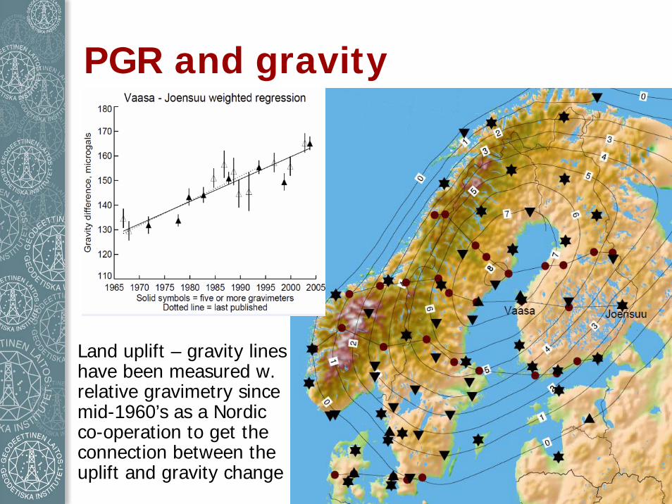
PGR and gravity
Land uplift – gravity lines have been measured w. relative gravimetry since mid-1960’s as a Nordic co-operation to get the connection between the uplift and gravity change

Combined geodetic Networks
Gravity
GNSS
Tide gauges
Combining observations

Objectives of the ECGN as an integrated European Reference System for Spatial Reference and Gravity are:
Realization of a terrestrial reference system and maintenance of long time stability with an accuracy 10-9 for Europe especially in the vertical component
In-situ combination of space geodesy (GPS) with Earth gravity parameters (gravity, heights)
Modelling of influences of time depended parameters to TRF (of the solid Earth of the Earth gravity field, the atmosphere, the oceans, the hydrosphere)
Modelling of terrestrial gravity field components to validate satellite gravity missionsGeodetic platform in Europe for geo-initiatives (GMES, INSPIRE, ...)
European Combined Geodetic Network

Example of a phenomena where GIA is affecting
The Glacial Isostatic Adjustment affects on:
Earth orientation parameters and reference framesPost-glacial uplift, contemporary movements and gravity: heights and height systemsDynamic ice sheets, glaciologyQuaternary palaeoenvironments and climateNeotectonics and seismotectonicsDynamics, structure, properties and composition of the lithosphere

Other signals mixed in GIA
The GIA signal is contaminated by several other spatially and temporally varying mass changes and crustal deformation. These include seismic deformation, mantle convection and plate tectonics
Sea level change is an example of a phenomenon which is related to GIA but mixed with other signals. The observed sea level change relative to a fixed benchmark on the ground contains components of • GIA related crustal vertical motion• Other crustal motions (tectonic, anthropogenic, ...) • Eustatic rise of the sea level • Seawater thermal expansion • Changes in semi-permanent sea surface topography• Geoid changes• Reference frame stability

Satellite gravimetry; GRACE
Mirjam Bilker-Koivula
Fennoscandian area problematic in satellite gravimetry: large variations in sea surface height of the Baltic Sea ”leaks” into land data; and opposite: changes in land water balance cannot be separated from the Baltic signal.
Superconducting gravimeter at Metsähovi,…

Future of height systemsUplift changes heights in Fennoscandia continuouslyNew height system every 50 years (next 2050?)Levelling is accurate but slow and expensiveNew techniques in the future (benchmarks needed?)
GNSS+ Gravity satellites+ Laser scanning+ SAR+ Levelling?+ Something else, hybrid/combination
1900 1920 1940 1960 1980 2000 2020 2040NN (N48) N60 N2000
N2050=========== =III III III III