Non-Technical Summary - IEMA · The SKM logo trade mark is a registered trade mark of Sinclair...
32
Stony Hill Wind Farm Environmental Statement Non-Technical Summary
Transcript of Non-Technical Summary - IEMA · The SKM logo trade mark is a registered trade mark of Sinclair...

Stony Hill Wind Farm Environmental Statement
Non-Technical Summary
The SKM logo trade mark is a registered trade mark of Sinclair Knight Merz Pty Ltd.
Stony Hill Wind Farm Environmental Statement
NON-TECHNICAL SUMMARY
FINAL FOR ISSUE
June 2013
Sinclair Knight Merz (Europe) Ltd Suite 3/4, 27 Waterloo Street Cadell House Glasgow G2 6BZ United Kingdom Tel: +44 141 226 7740 Fax: +44 141 248 4174 Web: www.globalskm.com
COPYRIGHT: The concepts and information contained in this document are the property of Sinclair Knight Merz (Europe) Ltd. Use or copying of this document in whole or in part without the written permission of Sinclair Knight Merz (Europe) Ltd constitutes an infringement of copyright.
LIMITATION: This report has been prepared on behalf of and for the exclusive use of Sinclair Knight Merz (Europe) Ltd’s Client, and is subject to and issued in connection with the provisions of the agreement between Sinclair Knight Merz (Europe) Ltd and its Client. Sinclair Knight Merz (Europe) Ltd accepts no liability or responsibility whatsoever for or in respect of any use of or reliance upon this report by any third party.
Stony Hill Wind Farm Environmental Statement Non-Technical Summary
SINCLAIR KNIGHT MERZ
PAGE i
Contents
1. Introduction 1
1.1. Project Description 2
1.2. The Applicant 2
1.3. Lead EIA Consultant 3
1.4. Need for the Project 4
1.5. Environmental Impact Assessment 5
1.6. Environmental Management 6
2. The Proposed Site 7
2.1. Overview of the Proposed Site 7
2.2. Site Selection 8
2.3. Site Layout and Design 8
3. The Proposed Development 9
3.1. Principal Components 9
3.2. Supporting Infrastructure 9
3.3. Construction 10
3.4. Operation 11
3.5. Decommissioning 11
4. Summary of Environmental Effects 13
4.1. Landscape Effects 13
4.2. Visual Effects 13
4.3. Cumulative Landscape and Visual Effects 14
4.4. Non-Avian Ecology 14
4.5. Ornithology 15
4.6. Archaeology and Cultural Heritage 16
4.7. Construction Traffic 17
4.8. Hydrology, Hydrogeology and Geology 18
4.9. Noise 19
4.10. Shadow Flicker 20
4.11. Recreation, Tourism and Outdoor Access 20
4.12. Telecommunications and Aviation 21
5. Viewing the Environmental Statement 23
5.1. Commenting on the Planning Application 23
EXAMPLE VIEWPOINTS 24
Stony Hill Wind Farm Environmental Statement Non-Technical Summary
SINCLAIR KNIGHT MERZ
Page | ii
Document history and status
Revision Date issued Reviewed by Approved by Date approved Revision type
A 18/04/13 Susie Meenan Mark Brown 22/04/13 DRAFT
B 24/04/13 Ben Ridder Susie Meenan 24/04/13 DRAFT
C 15/05/13 Karen Hamilton Karen Hamilton 01/05/13 FINAL DRAFT
D 22/05/13 Ben Ridder Ben Ridder FINAL FOR ISSUE
Distribution of copies
Revision Copy no Quantity Issued to
A 1 1 Mark Brown (SKM Enviros)
B 1 1 Ben Ridder (Infinis)
C 1 1 Karen Hamilton (Brodies)
D 1 1 Ben Ridder (Infinis)
E 1 1 Aberdeenshire Council (Paul Duthie)
Printed: 26 June 2013
Last saved: 26 June 2013 11:05 AM
File name: \\UK-EDI-FSV01\Projects\JEIA\Projects\JE30620\Deliverables\Reports\FINAL\ES\Stony Hill NTS FINAL FOR ISSUE.docx
Author: Various (SKM Enviros, Optimised Environments Ltd., AMEC Environment and Infrastructure UK Ltd., Natural Resource Projects Limited, WA Heritage Ltd.)
Project manager: Susie Meenan, SKM Enviros
Project director: Mark Brown, SKM Enviros
Name of organisation: Infinis
Name of project: Stony Hill Wind Farm EIA
Name of document: Non-Technical Summary
Document version: E
Project number: JE30620

Stony Hill Wind Farm Environmental Statement Non-Technical Summary
SINCLAIR KNIGHT MERZ
P a g e | 1
1. Introduction
This document is the Non-Technical Summary (NTS) of the Environmental Impact Assessment (EIA) carried
out for the proposed Stony Hill Wind Farm. The EIA has been prepared to support a planning application by
Stony Hill Wind Farm Ltd, a subsidiary of Infinis, to build and operate the wind farm over a period of 25
years.
As the proposed development will have a generating capacity of less than 50 MW, the application for
planning permission will be determined by Aberdeenshire Council, under section 37 of the Town and
Country Planning (Scotland) Act 1997 (as amended).
The EIA has been coordinated by SKM Enviros with specialist input from Optimised Environments Ltd.,
Natural Research Projects Ltd., AMEC Environment and Infrastructure UK Ltd., WA Heritage, GVA and
Infinis.
The details of the EIA are presented in the Environmental Statement (ES), which consists of two volumes:
Volume 1: Main Text and Figures – reporting the findings of the EIA in full with figures to accompany
the text; and
Volume 2: Technical Appendices – technical material to support the main text presented in Volume 1.
Volume 1 is divided into 14 chapters, as follows:
Chapter 1: Introduction
Chapter 2: Site Selection, Design and Consideration of Alternatives;
Chapter 3: The EIA Process
Chapter 4: Description of the Proposed Development;
Chapter 5: Planning Policy;
Chapter 6: Landscape and Visual;
Chapter 7: Ecology;
Chapter 8: Ornithology;
Chapter 9: Archaeology and Cultural Heritage;
Chapter 10: Construction Traffic;
Chapter 11: Hydrology, Hydrogeology and Geology;
Chapter 12: Noise;
Chapter 13: Other Issues (Shadow Flicker, Tourism, Recreation, Outdoor Access, Telecommunications,
Aviation)
Chapter 14: Glossary
Stony Hill Wind Farm Environmental Statement Non-Technical Summary
SINCLAIR KNIGHT MERZ
Page | 2
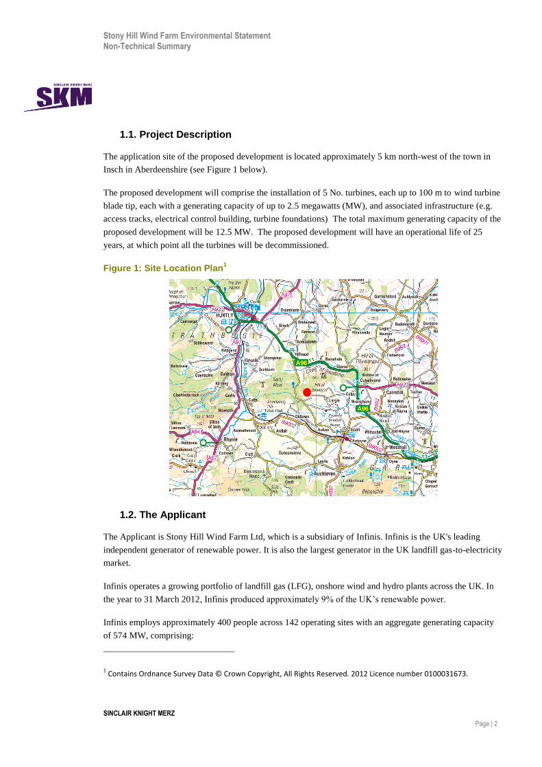
1.1. Project Description
The application site of the proposed development is located approximately 5 km north-west of the town in
Insch in Aberdeenshire (see Figure 1 below).
The proposed development will comprise the installation of 5 No. turbines, each up to 100 m to wind turbine
blade tip, each with a generating capacity of up to 2.5 megawatts (MW), and associated infrastructure (e.g.
access tracks, electrical control building, turbine foundations) The total maximum generating capacity of the
proposed development will be 12.5 MW. The proposed development will have an operational life of 25
years, at which point all the turbines will be decommissioned.
Figure 1: Site Location Plan1
1.2. The Applicant
The Applicant is Stony Hill Wind Farm Ltd, which is a subsidiary of Infinis. Infinis is the UK's leading
independent generator of renewable power. It is also the largest generator in the UK landfill gas-to-electricity
market.
Infinis operates a growing portfolio of landfill gas (LFG), onshore wind and hydro plants across the UK. In
the year to 31 March 2012, Infinis produced approximately 9% of the UK’s renewable power.
Infinis employs approximately 400 people across 142 operating sites with an aggregate generating capacity
of 574 MW, comprising:
1 Contains Ordnance Survey Data © Crown Copyright, All Rights Reserved. 2012 Licence number 0100031673.

Stony Hill Wind Farm Environmental Statement Non-Technical Summary
SINCLAIR KNIGHT MERZ
Page | 3
121 LFG sites (336 MW)
10 hydro sites (17 MW)
11 onshore wind farms (221 MW)
Infinis also has a strong onshore wind development portfolio comprising 53 MW in construction, 63 MW
consented, 74 MW determined, 94 MW in planning, 226 MW in development and approximately 352 MW at
various feasibility stages. Additionally, Infinis is seeking to grow and develop its hydro power assets.
1.3. Lead EIA Consultant
SKM Enviros (SKME) is part of the SKM (Sinclair Knight Merz) group and was appointed by Infinis to
coordinate the EIA and prepare the ES for the proposed Stony Hill Wind Farm.
SKM is an independent professional services consultancy firm with about 7,500 staff world-wide and offices
throughout the UK. SKM has considerable experience in the development, construction and operation of
wind farm developments throughout the UK, including the assessment of their environmental impacts.
SKME achieved the EIA Quality Mark status when it was introduced in 2011. The EIA Quality Mark is a
voluntary scheme operated by the Institute of Environmental Management and Assessment (IEMA), a
leading international organisation dedicated to the promotion of sustainable development and to the
promotion of best practice standards in environmental assessment and management. The EIA Quality Mark
signifies that our EIA activities have been independently reviewed by IEMA each year, to provide assurance
that SKME deliver EIA work of the highest standard in the following areas:
EIA Management
EIA Content
EIA Team Capabilities
EIA Regulatory Compliance
EIA Presentation
EIA Context
Improving EIA Practice
SKME has coordinated the technical teams providing input to the various EIA chapters. Details of the
principal authors for the technical topic chapters are shown in Table 1.

Stony Hill Wind Farm Environmental Statement Non-Technical Summary
SINCLAIR KNIGHT MERZ
P a g e | 4
Table 1: The EIA Project Team
ES Chapter
Topic Lead Organisation Company Website
1-4 Introduction
Site Selection, Design Evolution and Consideration of Alternatives
The EIA Process
Description of the Proposed Development
SKME
http://www.globalskm.com/
5 Planning Policy GVA http://www.gva.co.uk/planning/
6 Landscape and Visual Amenity Optimised Environments Ltd. (OPEN)
http://www.optimisedenvironments.com/
7 Ecology SKME http://www.enviros.com/
http://www.globalskm.com/
8 Ornithology Natural Research Projects Ltd.
http://www.natural-research.org/commercial-project-research/
9 Archaeology and Cultural Heritage Wessex Archaeology (WA Heritage)
http://www.wessexarch.co.uk/
10 Construction Traffic SKM Colin Buchanan
http://www.globalskm.com
11 Hydrology and Ground Conditions SKM Enviros http://www.globalskm.com/
12 Noise AMEC Environment & Infrastructure UK
http://www.amec.com/
13 Other Issues – Shadow Flicker. Tourism, Recreation, Access, Telecommunications, Aviation
SKM Enviros and Infinis
http://www.globalskm.com/
14 Glossary SKM Enviros http://www.globalskm.com/
1.4. Need for the Project
Climate change is the single biggest environmental threat facing the planet now and is an even greater threat
to future generations, anticipated to cause unpredictable, severe weather patterns with potentially catastrophic
effects on agriculture, wildlife, human health and the economy. Across Europe and globally, governments
have recognised the need to control and reduce CO2 emissions. One way of doing this is through the
generation of electricity from renewable energy sources, such as wind farms. Scotland has responded to the
challenges of climate change by passing the Climate Change Act (Scotland) 2009 and setting challenging
targets to reduce its emissions by at least 80% from 1990 levels by 2050, with an interim emissions reduction
target of at least 34% by 2020, increasing to 42% if the EU increases its 2020 target to 30% in the event of a
Stony Hill Wind Farm Environmental Statement Non-Technical Summary
SINCLAIR KNIGHT MERZ
Page | 5
global deal on climate change. Scotland has also set targets to generate 100% of Scottish gross electricity
consumption from renewable sources by 20202.
In addition, as non-renewable energy sources such as oil, gas and coal continue to decline, the UK must have
a diverse energy mix to ensure its energy needs are met. Currently, three quarters of our electricity comes
from coal and gas. Scottish energy policy now seeks to generate 100% of the electricity consumed in
Scotland from renewable sources by 2020. However, it is recognised that onshore wind technology does not
come without environmental impact, and that reducing emissions to meet this target requires a radical change
in the way in which society uses its energy and land.
Onshore wind is expected to provide the majority of capacity in the timeframe of the interim and 2020
renewable electricity targets. Wind power is an effective means of generating electricity. Today’s wind
turbines generate electricity 70-85% of the time, with the output dependent upon the wind speed. Turbines
will produce power from wind speeds of 3-4 metres per second (m/s) to 25 m/s, after which speeds they shut
down to prevent turbine damage. Over the course of a year wind turbines generate on average at 27%
(varying from 20 – 42%) of their theoretical maximum output. This measure of output is known as the
Capacity Factor.
1.5. Environmental Impact Assessment
The ES is the formal written statement of the findings of the EIA of the proposed development. The EIA as
an integral component of the wind farm design process. Environmental assessment is a continuous, iterative
process, used to inform all decisions in the development of a proposed development. Publication of the ES is
a formal stage in the development of proposals and is an important mechanism, along with the detailed
planning application, to impart information to and obtain views from the public.
The ES serves to:
Provide a description of the proposed development;
Provide an outline of the main alternatives and the reasons why these alternatives have not been taken
forward;
Ensure identification and full consideration of the likely significant environmental effects so that
decisions can be made with a knowledge of the environmental consequences of the proposed
development;
Identify ways in which the likely significant environmental effects can be addressed through design or
mitigation measures, and the likely success of these measures in rendering such effects insignificant;
and
Allow the key stakeholders (including the public and statutory environmental bodies) to comment on the
proposals, in order to take account of their concerns and views relating to environmental effects.
Therefore, it acts to aid the decision-making process and to present information in a readily accessible form.
2 2020 Routemap for Renewable Energy in Scotland, Scottish Government, 2011

Stony Hill Wind Farm Environmental Statement Non-Technical Summary
SINCLAIR KNIGHT MERZ
Page | 6
Through the publication of the ES, local communities are encouraged to contribute to the consenting phase
through active participation in the planning application consultation process, and which follows on from local
communities’ participation in the pre-application consultation process.
Details on how to view or purchase copies of the ES are provided at the end of this document.
1.6. Environmental Management
Infinis will identify an environmental management scheme with Aberdeenshire Council, which is likely to be
associated condition of the planning application should it be approved. Monitoring and site restoration
measures are expected to apply to ensure that the scheme is implemented throughout construction and
operation.
A Construction Method Statement (CMS) and Construction Environmental Management Plan (CEMP) will
be prepared prior to the start of construction, detailing measures to avoid or mitigate potential effects
associated with key construction activities. These will reflect and expand upon measures identified in the ES,
and will be agreed with Aberdeenshire Council, SEPA, SNH, Scottish Water and other stakeholders where
appropriate.
All work will be undertaken to relevant Health and Safety legislation. The project will be supervised in
accordance with the revised Construction Design and Management Regulations 2007 (CDM). Risk
Assessments will be undertaken for each work package prior to activities taking place.
Periodic environmental audits of the construction site will be carried out to monitor and record compliance
with the CEMP and to identify any areas of improvement. Additional monitoring will be undertaken as
required under obligations relating to the conditions of discharge consents, abstraction licences and other
environmental regulation.
After each element of the proposed development is constructed there will be a requirement to reinstate the
ground surface. Infinis will outline the methods and procedures which will be implemented during
construction as part of the implementation of planning conditions for the proposed development with
Aberdeenshire Council.
Stony Hill Wind Farm Environmental Statement Non-Technical Summary
SINCLAIR KNIGHT MERZ
Page | 7
2. The Proposed Site
2.1. Overview of the Proposed Site
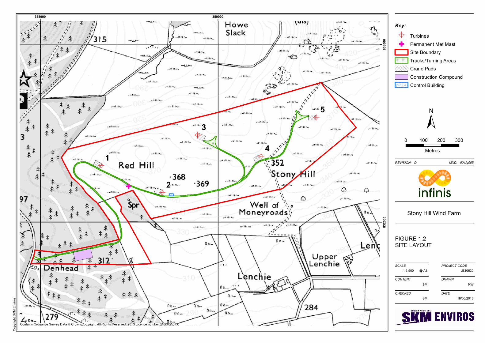
The proposed development site (henceforth referred to as the ‘application site’) is enclosed within the red line
area shown on Figure 2. It is located to the west and south of the main Aberdeen to Inverness road, the A96,
approximately 20 km north-west of Inverurie, 15 km south west of Huntly and 5 km north-west of Insch in
Aberdeenshire.
The application site occupies a total area of approximately 76.5 hectares (180 acres) and measures
approximately 3 km from east to west and 1 km from north to south. It encompasses two rolling hills to the
south-west of the Hill of Foudland; Red Hill and Stony Hill, both of which are dominated by heather-covered
moorland. Part of the application site has previously been planted with Scots pine as part of a commercial
forestry scheme, although these trees have not been successful and the plantation is considered to have been a
failure by the landowner. The site is not currently used for any commercial activity.
The ground on either side of Red Hill and Stony Hill slopes down to adjacent farmland and forests. There are
several small watercourses in the vicinity of the application site, although only one small drain has been
identified within the application site boundary. Figure 2 on the next page provides a visual representation of
the final site layout.
5
4
3
2
1
358000 359000
8320
0083
3000
FIGURE 1.2SITE LAYOUT
Stony Hill Wind Farm
1:6,500SCALE
CONTENT
CHECKED
PROJECT CODE
DRAWN
DATE
SM KW
SM 19/06/2013
@ A3
REVISION: D MXD: 001/g005
JE30620
Copy
right
SKM
Envir
os
Key:TurbinesPermanent Met MastSite BoundaryTracks/Turning AreasCrane PadsConstruction CompoundControl Building
0 100 200 300Metres
Contains Ordnance Survey Data © Crown Copyright, All Rights Reserved. 2013 Licence number 0100031673.

Stony Hill Wind Farm Environmental Statement Non-Technical Summary
SINCLAIR KNIGHT MERZ Page | 8
2.2. Site Selection
Infinis considered a large number of potential wind farm sites, of which several were located in
Aberdeenshire, including the Stony Hill site. The site was selected by Infinis for a number of reasons,
principally the following:
Exposed location with good wind speeds;
Lack of national designations onsite and in the vicinity;
Proximity to potential grid connection points;
Good access to transportation routes for construction traffic and turbine deliveries; and
Distance from residential receptors.
2.3. Site Layout and Design
Since its inception, the proposed development has undergone a number of changes in the design to best take
account of the surrounding environment. This process has been informed by specialist environmental studies,
as reported in the ES, and from consultation with relevant stakeholders including Scottish Natural Heritage,
Historic Scotland, the Scottish Environment Protection Agency, Aberdeenshire Council and members of the
local community. The location of turbines and associated access tracks has been carefully chosen taking into
account various site constraints. These constraints include proximity to residential properties, landscape,
visual, ecological and archaeological constraints, as well as the gradient of the terrain for the routing of
access tracks.
The layout design process is summarised in Table 2.
Table 2: Summary of Design Iterations
Key Stages Iteration and Reason for Iteration Detail and Resulting Change on Design & Layout
Starting point Seven turbine layout with turbine tower (hub) heights of 69m, wind turbine blade diameters of 92 m giving a turbine tower plus blade to tip height of 115 m.
Iteration 1 Increasing wind turbine separation to improve efficiency and increasing distance from houses to avoid effects on shadow flicker and reduce noise impacts.
Turbines moved to ensure minimum distance of 750 m from nearby houses and 414 m between adjacent turbines (4.5 x blade diameter). This resulted in a six turbine layout.
Iteration 2 Avoidance of effects on telecommunications links.
Turbines moved to incorporate acceptable stand-off distances from telecommunications links. One wind turbine was removed to give a five turbine layout.
Iteration 3 Minimise landscape and visual effects Turbine tower heights (excluding blades) reduced to 59 m, turbine blade diameters reduced to 82 m, giving a turbine tower plus blade to tip heights to 100 m. Turbines were also moved.
End point Final scheme comprising five wind turbines, giving a wind turbine tower plus blade tip.height of 100 m.
Stony Hill Wind Farm Environmental Statement Non-Technical Summary
SINCLAIR KNIGHT MERZ
Page | 9
3. The Proposed Development
The main elements of the wind farm are outlined below.
3.1. Principal Components
All of the following components will be present for the lifetime of the proposed development:
5 No. three-blade horizontal axis turbines (comprising three-blade rotor, nacelle and tower) each with a
hub height of up to 59 m above ground level and a rotor diameter of up to 82 m, resulting in a maximum
potential blade-tip height of up to 100 m above ground level (see Figure 2). Each turbine would be rated
at up to 2.5 megawatts (MW) generating capacity, giving a total installed capacity of up to 12.5 MW;
An electrical transformer and related switchgear for each turbine, which will be enclosed inside the
tower or located in a small container adjacent to the base of each turbine tower;
One control building and substation compound, combining an electrical substation and wind farm office
(containing electrical switchgear, control panels, wind farm control room, toilet and washing facilities);
and
One free-standing, lattice-type anemometer mast.
3.2. Supporting Infrastructure
Of the supporting infrastructure, the following components will be present for the lifetime of the proposed
development:
Turbine foundations;
On-site power collection system including electrical control building and compound and underground
cables between the turbines and the control building;
Approximately 2.97 km of new and upgraded access tracks for construction and operational vehicles,
with passing areas and turning points as required, with access from the main road network (the A96);
One 100 m by 50 m hardstanding area for the construction compound during the construction phase.
Following construction, the hardstanding will be retained on site for use by the Landowner;
Grid connection – The grid connection will be subject to a separate consenting process managed by
Scottish Hydro Electric Power Distribution (SHEPD). The likely grid connection points are Huntly or
Keith, with the electricity exported along an underground cable or new power line on wooden poles.
Of the supporting infrastructure, the following components will be required for a temporary period during
construction of the proposed development:
Five hardstanding areas for cranes for installation and maintenance (crane pads), one adjacent to each
turbine location (30 m x 40 m);
Car parking area, wheel washing facility, material storage area and site offices (part of the construction
compound that will be retained only for the duration of the construction programme); and

Stony Hill Wind Farm Environmental Statement Non-Technical Summary
SINCLAIR KNIGHT MERZ
Page | 10
One temporary laydown area (50 m by 50 m).
Figure 3: Typical Turbine
3.3. Construction
Construction of the wind farm will comprise the following main tasks. These are listed below in sequence,
however, some will overlap and some activities will be undertaken in parallel:
Undertake any works / improvements to public roads;
Construct site entrance and new tack to the position of the
temporary construction compound and install accommodation;
Construct new access tracks, a single watercourse crossing,
satellite compound and crane hard standings;
Excavate the wind turbine foundations and construct the turbine
bases;
Construct control building and substation;
Excavate cable trenches and lay the power and instrumentation
cables;
Blade-Tip Height 100 m (maximum)
Rotor diameter 82 m (maximum)
Rotor diameter 59 m (maximum)

Stony Hill Wind Farm Environmental Statement Non-Technical Summary
SINCLAIR KNIGHT MERZ
Page | 11
Install the grid connection;
Excavate, erect and commission the permanent anemometer masts;
Erect and commission the wind turbines including external transformers;
Carry out reinstatement works; and
Remove temporary facilities and clear the site.
In general, working hours for construction will be from 07.00 to 19.00 Monday to Friday and 07.00 to 13.00
on Saturday. No working is proposed on Sundays and public holidays.
A construction workforce of, on average, 24 people could be working on the site per day over the
construction period, though not all will be on site at the same time and some months (Months 1 & 2 for
example) will have less activity on site than others.
3.4. Operation
The proposed development will have a planned operational life of 25 years. On a day to day basis the wind
turbines will operate automatically, responding by means of anemometry equipment and control systems to
changes in wind speed and direction. The wind farm will be remotely monitored by Infinis.
Depending on the final choice of turbine, the wind turbines will start to generate when the wind speeds at
nacelle hub height reach approximately 3 m/s, attaining their maximum output at around 13 m/s. At
continuous wind speeds above 25 m/s the turbines will automatically shut down for protection health and
safety reasons. The turbine rotor operates at between 6 rpm and 16 rpm dependent on wind speed and all
turbines will rotate in the same direction.
As part of its routine maintenance programme, Infinis will perform checks and scheduled servicing. In
addition there may be a requirement for unscheduled maintenance, which might vary between resetting
alarms to major component changes requiring a crane. Typically maintenance traffic will be four-wheel drive
vehicles and vans. In addition to the turbines, the substation and tracks will also require periodic
maintenance.
Once operational, staff employed on the wind farm would comprise a team of approximately 4 people to do
servicing and maintenance for 4 or 5 weeks a year. This number will be supported periodically by a
combination of civil and electrical contractors and remote site management staff.
3.5. Decommissioning
Following the expiry of the 25 year planning consent the development will either be decommissioned, or an
application made to extend the planning consent. It is estimated that decommissioning the development,
given its size, will take approximately 6 to 9 months.
Decommissioning will involve the removal of all above ground infrastructure. Demolition of the control
building will involve the removal of the equipment followed by demolition of the building. All demolition
waste will be removed to a licensed waste disposal site. The plinth and the top surface of the wind turbine

Stony Hill Wind Farm Environmental Statement Non-Technical Summary
SINCLAIR KNIGHT MERZ
Page | 12
foundation bases will be broken out and removed to approximately 1 m below ground level and all cabling
will be cut out at the same depth. The area will then be reinstated with a final layer of topsoil over the
foundations. Tracks will be left in situ for use by the landowner. No stone will be removed from the site
during decommissioning. This approach is considered to be less environmentally damaging than removal of
all foundations, underground cables and tracks.
A decommissioning method statement will be prepared and agreed with the relevant statutory consultees
prior to decommissioning of the site.
Stony Hill Wind Farm Environmental Statement Non-Technical Summary
SINCLAIR KNIGHT MERZ
Page | 13
4. Summary of Environmental Effects
4.1. Landscape Effects
An assessment of the effect of the proposed development on the landscape has considered the direct physical
effect on the landscape fabric of the application site, the effect on local landscape character areas, and the
effect on areas covered by landscape designations within the study area.
The principal physical effect that the proposed development will have on the landscape fabric of the site is
the removal of a small area of heather moorland. However, the effect of this change on the landscape is
assessed as not significant given the small proportion of heather that will be removed.
The landscape character area (LCA) in which the proposed development is located is part of an upland spur
of the Grampian Outliers LCA, which extends from the central massif of the Cairngorms into the farmed
landscape of Garioch and Formartine. The area of this LCA in the vicinity of the site is described in the
assessment as the ‘Ridge of Foudland’. The proposed development is located on Red Hill (375 m) and Stony
Hill (352 m), occupying a central position within the Ridge of Foudland. The application site is lower than
the adjacent hills at Hill of Foudland (467 m) and Wishach Hill (419 m), which provide enclosure to the
north-east and north-west. Gartly Moor and the Hill of Tillymorgan are heavily wooded with commercial
coniferous plantation and communications masts on Hill of Corskie and Hill of Foudland are features in
views of the skyline. The Ridge of Foudland forms a backdrop to the lower lying and more settled
agricultural heartlands to the south (Insch Basin LCA) and the north (Northern Rolling Lowlands LCA).
The main changes to the landscape character of the study area as a result of the proposed development arise
in the landscape immediately around the proposed development – within the Ridge of Foudland, Northern
Rolling Lowlands and Insch Basin. The level of effect of the proposed development on the Ridge of
Foudland landscape unit is assessed as locally significant within approximately 3 km of the site, around Red
Hill, Stony Hill, Hill of Foudland, Gartly Moor and Saddle Hill.
4.2. Visual Effects
The assessment of effects on views indicates that the proposed development will have significant effects on
views and visual receptors within about 8 km of the site. The effect of the proposed development on more
distant views, such as from Mither Tap and Tap o’Noth, is generally assessed as not significant. With regard
to effects on Insch, although the effect on views has been assessed as significant, it should be noted that there
are very few locations within the town with unobstructed views of the proposed turbines.
The visual effect on many of the route corridors in the study area is assessed as not significant due to distance
and the transitory nature of the view from these receptors. The effect of the proposed development is assessed
as significant on views from the A96 for a short stretch between Glens of Foudland and Dummuies, and
significant on views from the Hill Road for a short section between Gartly Moor and the A96.
Viewpoints have been chosen partly to enable consideration of ‘valued views’ identified in the Aberdeenshire
Local Development Plan. The main valued views that may be affected by the proposed development include
Stony Hill Wind Farm Environmental Statement Non-Technical Summary
SINCLAIR KNIGHT MERZ
Page | 14
views of Dunnideer Hill Fort from the surrounding area and the view from the top of Suie Hill on the Alford
to Kennethmont road.
Two example viewpoints from the landscape and visual assessment of the proposed development are
provided at the end of this Non-Technical Summary.
4.3. Cumulative Landscape and Visual Effects
As well as assessing the effect of the proposed development itself, the landscape and visual assessment also
assessed the cumulative effect of the proposed development in conjunction with other operational, consented,
and application stage wind farms. Glens of Foudland and Dummuie Wind Farms have a particular influence
on the baseline landscape character of the area to the north of the site.
Although the proposed development contributes to the influence of wind farms in a localised area, it will not
change the overall existing landscape character. The main cumulative landscape effect resulting from the
proposed development is to extend the influence of wind farms from the A96 corridor north of the site to the
adjacent Ridge of Foudland. This effect has been assessed as significant.
The cumulative effect of the proposed development is not significant for views from the north, where the
proposed development will be visible in combination with Glens of Foudland and/or Dummuie, both of
which utilise turbines with a height to blade tip of 80 m. The difference in height between the proposed
turbines and these operational wind turbines is difficult to discern because of the perspective effect resulting
from the distance between the viewer and the turbines. In views from the north, the main area with combined
visibility, Glens and Dummuie turbines will appear larger in comparison to Stony Hill because they are
closer to the viewer. To the majority of observers, the primary visible difference between Stony Hill and
Glens / Dummuie will be that the latter consist of more tightly clustered groups of turbines, and as such, that
their aesthetic quality is more cluttered and visually complex within an agricultural landscape. In this regard,
the Stony Hill turbines respond to the simple visual characteristics of the Ridge of Foudland as a single line
upon the landform with wider spacing between turbines, complementing the landform in their positioning,
extent and turbine density.
However, the assessment has identified significant cumulative effects on views from the Hill Road that runs
to the west of the site, and on the more distant views from upland landscapes to the south and west, such as
Bennachie and Tap o’ Noth. The larger vertical scale and spacing of the proposed turbines is distantly evident
in comparison to Glens of Foudland and Dummuie, as is the higher elevation of the turbines on the skyline.
4.4. Non-Avian Ecology
Within 10 km of the application site there are only four areas designated for nature conservation interest, of
which only one is designated for its non-avian biological status. This is the Moss of Kirkhill Site of Special
Scientific Interest (SSSI), which is located 5 km southwest of the application boundary, and is designated for
small basin fen habitat. Due to the intervening distance, there will be no effect on this area.
Surveys of non-avian ecology comprised an Extended Phase 1 Habitat Survey, a National Vegetation
Classification Survey, a Bat Survey and a Protected Mammals Survey.

Stony Hill Wind Farm Environmental Statement Non-Technical Summary
SINCLAIR KNIGHT MERZ
Page | 15
Habitats on-site consist of coniferous plantation woodland and improved pasture in the area of the lower
access track, and dry dwarf shrub heath on the upper area of the application site where the turbines are
proposed. An area of marshy grassland and flush is also found near the northern boundary of the site, on
lower ground between Stony Hill and Red Hill..Very low levels of bat activity were recorded in the study
area, with no potential roost features identified and the pattern of bat movement suggesting that bats roost off
site.
There was evidence of badger in the study area, although no setts are located within 200 m of the application
boundary. No evidence was recorded of water vole. No evidence was recorded of squirrels in the mammal
survey although some of the woodland along the proposed site access track was confirmed to have the
potential to support red squirrel. No signs of other protected or notable species, such as freshwater pearl
mussel, amphibians, reptiles, pine marten, otter, wildcat, brown hare or mountain hare, were recorded in the
ecological surveys. Habitats on site are not considered to have the potential to support these species, although
pine marten, wildcat, brown hare and mountain hare might occasionally be present on site. Signs of rabbit,
roe deer and red fox were recorded throughout the application site and a possible bank vole burrow was
recorded approximately 500 m from the site.
Habitats and plant species outwith the application boundary are unlikely to be directly impacted by
construction of the proposed development. Indirect impacts might include changes to hydrological conditions
for wetland habitats and plants. Dry habitats, such as scree and juniper are not likely to be impacted.
None of the marshy grassland or flush habitats will be permanently lost, and no temporary disturbance is
predicted for these habitats or for wet heath outwith the application boundary. Of the 66.67 ha dry dwarf
shrub heath within the application boundary, 3.61% will be permanently lost and a further 5.23% will be
temporarily disturbed during construction.
Prior to construction a CMS and CEMP will be produced and agreed with Aberdeenshire Council in
consultation with SNH and SEPA. This will contain full details of measures to minimise the impact on
ecologically sensitive features on the application site. A Habitat Management Plan (HMP) will be produced
to detail the optimum management of the site’s heath habitat over the lifetime of the wind farm. This will
mainly involve prescriptions regarding the frequency of heather mowing and/or muirburning (where safe)
which will be in place for the lifetime of the wind farm. Following implementation of these mitigation
measures, the anticipated effect of the wind farm on protected species and other valued ecological features
during construction, operation or decommissioning will not be significant.
4.5. Ornithology
The nearest designated areas for birds are the Tips of Corsemaul and Tom Mor Special Protection Area
(SPA), approximately 18 km east, and Correen Hills SSSI approximately 10 km south, both designated for
breeding common gulls. As there is no likelihood of an effect on these areas, SNH agreed that no assessment
was required.
Bird surveys in for the proposed Stony Hill wind farm were undertaken in accordance with SNH guidance
between September 2011 and August 2012. The main survey objectives were to identify breeding and

Stony Hill Wind Farm Environmental Statement Non-Technical Summary
SINCLAIR KNIGHT MERZ
Page | 16
wintering bird species within prescribed areas around the proposed development and to quantify flight
activity during the breeding and non-breeding seasons.
The results of the baseline surveys showed that although a number of species of conservation concern were
recorded (including peregrine, merlin, hen harrier, goshawk, red kite, short-eared owl, golden plover, curlew,
crossbill, skylark and pink-footed goose) they were recorded infrequently and in relatively small numbers.
This indicates a very low dependence on the habitats and airspace in the vicinity of the proposed
development, and consequently the proposed development will have negligible effects on the relevant
populations of these species.
Due to the baseline results and given regional abundance and/or behavioural sensitivity of all the species
noted, there is considered to be no potential for any adverse effects on regional populations as a result of
construction, operational or decommissioning activities.
4.6. Archaeology and Cultural Heritage
Potential impacts of the proposed development on cultural heritage assets consist of direct physical impacts
on archaeology and indirect impacts to the setting of cultural heritage assets.
The assessment consisted of a desk-based study supported by archive research, two walkover surveys within
the application boundary, and site visits to selected cultural heritage receptors. These receptors included
Scheduled (Ancient) Monuments, Gardens and Designed Landscapes, Category A-listed and selected B-
listed structures. The study included an assessment of the potential for encountering unknown cultural
heritage assets within the footprint of the proposed development.
There are no designated cultural heritage receptors within the application boundary. There are, however, 44
undesignated cultural heritage assets including four previously unknown features of possible cultural heritage
interest that were recorded during the walkover surveys.
The undesignated cultural heritage assets reflect historically recorded distributions of crofts and farmsteads
on the south and north flanks of Red Hill and Stony Hill. The proposed development area appears to have
been primarily used for access between crofts and farmsteads. These, and the Hill of Foudland quarries, were
active during the post-medieval period.
There is significant potential for encountering unknown cultural heritage assets associated with this historic
land-use in the vicinity of the proposed access track where it leaves the forested area. The route of the
proposed track avoids the locations of known features, although will cross a feature identified during the
survey as possibly a historic track.
The significance of the effect of construction on the possible historic track and any associated remains are
likely to be negligible following the agreement of mitigation with Aberdeenshire Council, which could
include the presence of an archaeologist during construction of the track through this area.
There is a low potential for encountering unknown cultural heritage assets of medieval to prehistoric date in
the main area of the application site where turbines are proposed.

Stony Hill Wind Farm Environmental Statement Non-Technical Summary
SINCLAIR KNIGHT MERZ
Page | 17
The proposed development is likely to have a significant effect on the setting of the Scheduled Monument
(although not the Category B-listed castle ruins) on the Hill of Dunnideer.
No significant cumulative effects have been identified.
4.7. Construction Traffic
An assessment of the effects of the predicted increase in traffic associated with the development construction
programme has been undertaken. The assessment considered the effects of the increase in traffic on the road
network, settlements, schools and hospitals. A number of potential access routes for the delivery of turbine
components have been established and assessed with the proposed route identified as follows:
Established abnormal load route between the ports of Peterhead or Aberdeen to the A96;
Continue on A96 to Hillhead; and
South on the unclassified Hill Road to the proposed site entrance approximately 4.5km south of the
junction with the A96.
This route requires the proposed upgrade to the Inveramsay railway bridge on the A96 to have been
completed prior to construction of the proposed development. However, in the event that this might not take
place in time, the EIA includes assessment of an alternative route that leaves the A96 at Inverurie, travels
north and west along Burghmuir Drive, the B9001 and A920 to Kirkton of Culsalmond, before rejoining the
A96.
Consultation was undertaken with Transport Scotland, Bear Scotland and Aberdeenshire Council all of whom
had no major issues with regards to the development.
Over the 9 month construction programme it is estimated that there would be a total of 16,319 vehicle
movements associated with the development.
The assessment concentrated on the A96, A920, B9001, Burghmuir Drive, and the Hill Road leading to the
application site entrance. These are the roads which will experience the largest increase in traffic as all traffic
would have dispersed onto the wider road network beyond this assessment area.
Traffic count information was obtained from a combination of Transport Scotland data and commissioned
counts. The assessment then considered the increase in traffic as a result of the development based on
monthly averages during the 9 month construction programme. In order to provide a robust assessment it
was assumed that all development traffic could potentially travel to the development exclusively via each
road, whereas in reality, not all vehicles will pass through Inverurie, for example.
In terms of overall traffic impact, the construction of the proposed development will have a minor impact
upon the road network, with the maximum increase in traffic occurring on the Hill Road, between the A96
and the application site entrance, during the busiest month of the programme. The proposed development will
have no significant effects at any of the other assessed locations.

Stony Hill Wind Farm Environmental Statement Non-Technical Summary
SINCLAIR KNIGHT MERZ
Page | 18
Notwithstanding this, a number of mitigation measures are proposed in order to further minimise any impacts
associated with the proposed development, most important being the preparation of a Traffic Management
Plan (TMP) prior to construction.
With regards to abnormal loads, the following mitigation measures are proposed:
Improvements to identified roads and/or junctions on the proposed Turbine Delivery Vehicle (TDV)
access route;
All movements will take place outside of peak flow hours, in order to minimise disruption to general
traffic flows on the network;
A police escort will accompany all TDVs;
Appropriate warning signs will be used to warn other road users of the presence of TDVs; and
Considering the short term nature of the traffic increase and the mitigation measures outlined above, there
will be no significant residual effects during the construction period.
Traffic movements during the operational phase of the wind farm will be largely limited to occasional visits
by cars and vans and would not be expected to exceed 10 vehicle movements per day, and the effects are
therefore not significant.
4.8. Hydrology, Hydrogeology and Geology
The assessment included a desk-based data review, a site visit and consultation with including SEPA,
Scottish Water, Aberdeenshire Council, the River Don District Salmon Fishery Board and property owners.
For the assessment, a level of risk associated with each potential impact was assigned to all identified
sensitive receptors within, surrounding and downstream of the application site, according to best practice
guidance. In particular, an integrated approach to hydrology, hydrogeology and ecology was adopted to
understand and assess potential impacts on GWDTEs.
The application site is located within the headwater catchments of the River Urie within the River Don
catchment. It is drained by tributaries to the River Shevock to the west, tributaries to the Burn of Stodfold
draining to Glen Water to the north and tributaries to the Burn of Largie which drains to The Kellock to the
south-east. It can be sub-divided into three main surface water runoff catchments, two of which drain the
southern portion of the application site and one that drains the northern portion. There are no marked
channels within the application site, however there are several unmarked channels and man-made drains
within the application site and immediately downstream. Anecdotal evidence indicates that some of these
channels are often overgrown with rushes and other vegetation, or are dry. A peat depth survey was
undertaken, with only several isolated areas all less than 50 cm deep being found.
The proposed development site has several nearby residential properties. Consultation with Aberdeenshire
Council indicated that there were several properties known to be using PWS within a 2 km radius of the
application site boundary which are hydraulically connected to catchments within the site. Further
consultation has been undertaken with individual property owners to determine exact locations of supplies
and storage.
Stony Hill Wind Farm Environmental Statement Non-Technical Summary
SINCLAIR KNIGHT MERZ
Page | 19
Baseline conditions for all identified sensitive receptors within and downstream of the proposed site (if
hydraulically connected) were identified and mapped.
Identified constraints have been avoided in the design and layout of the proposed development in order to
minimise potential adverse impacts. This has included providing a minimum buffer zone of 50 m around the
watercourses of Burn of Stodfold, Burn of Largie and The Shevock and their tributaries. Drainage channel
crossings have also been avoided where possible, and only one crossing is required, of an agricultural drain
to the west of the proposed location of the anemometer mast. Turbine locations have been refined with a
view to avoiding foundation excavations in areas near GWDTEs and a separation distance of at least 100 m
has been maintained between turbines / infrastructure and GWDTEs. Where this infrastructure remains
within 100 m upslope of a GWDTE, mitigation is proposed.
Mitigation measures were also developed to address any potential significant impacts associated with the
construction, operation and decommissioning of the proposed development. The CEMP will incorporate
good practice techniques in the detailed design of the proposed development. For example, site drainage will
be designed so that it does not significantly alter existing runoff patterns, and sediment control measures will
be implemented to control runoff and sediment generation from construction areas.
Overall, the residual effects of the proposed development on the water environment after mitigation are
considered to be minor and not significant. Predicted residual effects are limited to short term increased
sediment loading of downstream watercourses during construction, the potential for pollution from accidental
spillages of substances, and minor impacts to groundwater and GWDTEs and soil from earth movement
activities.
4.9. Noise
An assessment considering noise from construction, operation and decommissioning was carried out for the
proposed development. For each of these phases the assessment considers compliance with the applicable
noise limits.
The assessment shows that the separation distance between the construction areas and receptors is sufficient
to ensure that any construction noise effects will not cause undue disturbance. It is assumed that
decommissioning noise will be generally less or, at most, similar to that experienced during the construction
period. Therefore, no significant effects are anticipated in respect of noise from construction and
decommissioning activities.
Operational noise was assessed in accordance with ETSU-R-97 guidance: ‘The Assessment and Rating of
Noise from Windfarms’ ("ETSU Guidance") and advice provided by Aberdeenshire Council’s Environmental
Health Department. The assessment was based upon the REpower MM82 as the candidate turbine and
predicts that operational noise levels will be within the derived noise limits. This assessment is based on
measurements taken at 6 locations, and assesses 14 residential receptors surrounding the proposed
development.

Stony Hill Wind Farm Environmental Statement Non-Technical Summary
SINCLAIR KNIGHT MERZ
Page | 20
The operational noise assessment was extended to consider potential cumulative noise effects resulting from
the existing Dummuie and Glens of Foudland Wind Farms, and the single turbines at Stodfold and
Brankston. The cumulative assessment has demonstrated that when residential receptors are downwind of all
the proposed wind projects, operating concurrently, calculated noise levels are well below the ETSU
guidance limits. This is considered a conservative approach as it is not possible for receptors to be directly
downwind of all the wind turbines in the area at any one time. Therefore, no significant cumulative noise
effects are predicted.
There is no evidence to support the assertion that low frequency noise or vibration, either ground borne or
airborne, due to the operation of wind farms, causes potential adverse impacts. Studies of operational wind
farms have found very low levels of low frequency noise or vibration, substantially below levels likely to
have any effect on humans or structures.
In conclusion, this assessment shows that the proposed development will comply with all relevant standards
and guidelines designed to protect residential amenity in respect of noise.
4.10. Shadow Flicker
Under certain combinations of geographical position and time of day, the sun may pass behind the rotors of a
wind turbine and cast a shadow over neighbouring properties. When the blades rotate, the shadow flicks on
and off resulting in an effect known as ‘shadow flicker’. The persistent occurrence of shadow flicker on a
domestic property can be perceived as a nuisance by residents. Scottish Government guidance states that, “In
most cases, where separation is provided between wind turbines and nearby dwellings (as a general rule 10
rotor diameters), “shadow flicker” should not be a problem.”
Although there are no local or national UK mandatory requirements or criteria for assessing shadow effects
caused by wind turbines, Predac, an EU sponsored organisation promoting best practice in energy use and
supply, suggests that a maximum of 30 hours of shadow flicker in a calendar year is acceptable, with no
longer than 30 minutes on any single occasion. In the case of the Stony Hill Wind Farm, the modelling for
this assessment has been based on a turbine with a rotor diameter of 82 m and, therefore, this zone extends to
820 m (10 x rotor diameter) from each turbine. Lenchie is the only property which could potentially be
affected by shadow flicker.
The predicted number of hours of shadow flicker has been calculated using specialist software, and it
indicates that there will be no exceedences of 30 minutes per day and/or 30 hours per year at Lenchie. It is
therefore judged that there will be no significant effects resulting from shadow flicker and no mitigation
measures are required.
4.11. Recreation, Tourism and Outdoor Access
An assessment has been undertaken as part of the EIA to identify the potential tourism and recreational /
outdoor access impacts in proximity to the area of the application site and how they are likely to be affected
by the proposed development.

Stony Hill Wind Farm Environmental Statement Non-Technical Summary
SINCLAIR KNIGHT MERZ
Page | 21
Key tourist attractions situated in or around Insch and Huntly include the Bennachie and Correen Hills to the
south and Tap o’ Noth and Clashindarroch to the west. There is one long distance walking route within 10
km of the proposed development – the Gordon Way – which partly follows old peat extraction routes in the
Bennachie hills and forests. There are no National Cycle Routes within 10 km of the application site,
although there are circular routes for cyclists between Insch and the Hill of Foudland that make use of public
roads.
There are no formal designated Core Paths covering the proposed site, but land in the local area is used
regularly for walking and other outdoor recreational activities, with a wider network of paths available to the
public.
There is only one track marked on Ordnance Survey maps passing through the application site although this
has been inaccessible for some time due to the dense growth of gorse. The public road to the west is
separated from the application site by commercial forestry plantation. There is evidence of recreational
access to the site by way of an unmarked, rough track through the forest, entering the site along the western
ridge of Red Hill. It can be assumed that this is a route used by local walkers who wish to climb to the
summit of the Hill of Foudland from the west. No data is available for the level of recreational use, although
given that the track displays limited signs of regular use, it is unlikely to receive more than 100 visits per
year.
The effects of the proposed development will, during construction, operation and decommissioning, largely
depend upon how it affects tourism resources / facilities or changes the visitor / user pattern, and hence
visitor and recreational enjoyment. During the construction and decommissioning periods, these effects are
likely to be related to the effect of construction traffic on the local road network. These effects will be
temporary and geographically localised and are not considered to be significant. During operation, effects
will be largely due to changes in user behaviour due to views and visual amenity in the wider landscape and
these are summarised in Section 4.1 above. Recent research commissioned by Tourism Scotland found that
80% of UK respondents do not believe that the presence of wind farms would affect their decisions about
holiday destinations3.
There will be a minor beneficial effect for local walkers, who will be able to use the wind farm tracks to gain
access to the Hill of Foudland.
4.12. Telecommunications and Aviation
Ofcom was consulted with a request for information on any fixed telecommunications links that could be
affected by the proposed development and provided a list of eight telecommunication links in the area. Each
of these organisations was subsequently consulted by Infinis to determine the telecommunication link details,
including frequency and link-end coordinates. This information was incorporated into the wind farm design
process to maintain the buffer zones required to ensure that there would be no interference to the identified
3 http://www.visitscotland.org/pdf/Revised%20Oct%2012%20%20Insights%20Wind%20Farm%20Topic%20Paper.pdf
(accessed March 2013)

Stony Hill Wind Farm Environmental Statement Non-Technical Summary
SINCLAIR KNIGHT MERZ
Page | 22
links. Technical studies were undertaken by JRC and PagerPower indicating that the proposed turbines would
not impact on the identified links.
An aviation study carried out by NATS has identified that any anticipated impact on Allanshill Radar and
Perwinnes Radar would be acceptable to the users of these radars.
Although Stony Hill is 52 km from the RAF Buchan radar, some of the turbine blades will be visible to the
radar and an objection from the Ministry of Defence (MOD) is anticipated. However, it should be noted that
the model of radar at RAF Buchan (Lockheed-Martin Type 92) is capable of being upgraded to the
Lockheed-Martin TPS77, which has been installed elsewhere in the UK specifically because of its increased
compatibility with wind turbines. In March 2013, the MOD removed their objection to an offshore wind farm
proposed for Aberdeen Bay (the Vattenfall European Offshore Wind Deployment Centre) and an onshore
wind farm proposed for Mormond Hill (Muirden Energy). It is anticipated that Infinis will be able to agree a
planning condition with the MOD that will allow them to remove any objection. Subject to the agreement and
implementation of this condition, the effect on RAF Buchan radar is not likely to be significant.
The BBC online wind farm assessment tool has identified that the TV transmitters that serve the area
surrounding the application site are Gartley Moor and Durris, and that the proposed development may affect
TV reception at homes for which there is no alternative off-air service. The majority of these homes are to the
south-west of the application site. In the event that TV or mobile phone reception was affected by the
turbines, this would be resolved at the Applicant’s expense through straightforward mitigation measures,
such as the provision of satellite TV aerials.

Stony Hill Wind Farm Environmental Statement Non-Technical Summary
SINCLAIR KNIGHT MERZ
Page | 23
5. Viewing the Environmental Statement
During the statutory consultation period (21 days from application validation date, expiry date of any advert
or neighbour notification), the Stony Hill Wind Farm Environmental Statement may be viewed at the
following locations during normal opening hours:
Aberdeenshire Council Offices, Gordon House, Blackhall Road, Inverurie, AB51 3WA
The non-technical summary is available free of charge, and an electronic copy of the ES is available on CD
for £5.00 each (including VAT). All documents can be obtained by writing to:
Infinis
27/1 Thistle Street
Edinburgh
EH2 1DX
The planning documents will also be available to view on the Aberdeenshire Council online planning portal.
Internet links and news updates will be posted on the Infinis website, along with a selection of documents
that can be downloaded (see http://www.infinis.com/stony-hill/).
5.1. Commenting on the Planning Application
During the consultation period, any individual, group or organisation can submit comments (called “making a
representation”) on a planning application. This must be done in writing to the planning authority or online
via the planning portal.

Stony Hill Wind Farm Environmental Statement Non-Technical Summary
SINCLAIR KNIGHT MERZ Page | 24
EXAMPLE VIEWPOINTS

Photomontage view from A96, Hill Road Junction (72 degrees horizontal field of view, 32 cm viewing distance) View direction 163 degrees.
Existing view from A96, Hill Road Junction (72 degrees horizontal field of view, 32 cm viewing distance) View direction 163 degrees.

Photomontage view from Insch, Train Station (72 degrees horizontal field of view, 32 cm viewing distance) View direction 320 degrees.
Existing view from Insch, Train Station (72 degrees horizontal field of view, 32 cm viewing distance) View direction 320 degrees.

Stony Hill Wind Farm Environmental Statement