Nomination form of heritage irrigation structures
16
Nomination form of heritage irrigation structures 1. Details of irrigation structure nominated (a) Name: Ogawazeki irrigation canal (b) Year of commissioning: Unknown (estimated about 400 years ago) (c) Area irrigated (or area drained for drainage structures):104 ha (d) Geographical coordinates: Lies at 36.23266º north latitude and 138.91926º east longitude (e) River basin where located: Ogawa River, Class A river (f) Name of the nominating national committee: Japanese National Committee of ICID 2. Management details of the nominated structure (i) Ownership (include both the owner and the management body if they are different) a. Name of organization: Kanra Town, Gunma Prefecture b. Address: 161-1, Obata, Kanra-machi, Kanra-gun, Gunma (ii) Person in charge and contact: Mutsuhiro Tanaka, Regional Development Department (Tel: 0274-74-3131, e-mail: [email protected]) (iii) Present source of fund for operation and maintenance of the nominated structure: General budget of Kanra Town 3. Description of the overview and features of the nominated structure Introduction of Kanra Town Kanra Town is located in the southwestern part of Gunma, 100 km away from the Tokyo metropolitan area, and bounded by Takasaki City on the east, by Tomioka City on the west and the north and by Fujioka City and Shimonita Town on the south. It has a variety of terrains including Mt. Inafukumi with an altitude of 1,370 m sloping down to the north, a mountainous area in the south, a hilly area in the center and a plan area in the north. Kabura River runs along the northern border with Tomioka City and, in the Town, small-and-medium-sized rivers including Ogawa River, Shirakura River and Amabikigawa River run from south to north, meeting Kabura River. The town has inland climate and is relatively-warm. It has few snow and natural disasters such as earthquake and typhoon and is a comfortable place to live. The town also has many historic sites and cultural properties which tell the prosperity from ancient times and provides a panoramic view of Joumou-sanzan, Joshinetsu border and Mt. Asama. Kanra is a place of scenic beauty surrounded by the nature with rich history and culture. Ogawazeki irrigation canal It is estimated that a masonry irrigation structure, Ogawazeki irrigation canal (a main canal) was constructed over 400 years ago, but the exact year of construction is unknown. It has been used for
Transcript of Nomination form of heritage irrigation structures

Nomination form of heritage irrigation structures
1. Details of irrigation structure nominated
(a) Name: Ogawazeki irrigation canal
(b) Year of commissioning: Unknown (estimated about 400 years ago)
(c) Area irrigated (or area drained for drainage structures):104 ha
(d) Geographical coordinates: Lies at 36.23266º north latitude and 138.91926º east longitude
(e) River basin where located: Ogawa River, Class A river
(f) Name of the nominating national committee: Japanese National Committee of ICID
2. Management details of the nominated structure
(i) Ownership (include both the owner and the management body if they are different)
a. Name of organization: Kanra Town, Gunma Prefecture
b. Address: 161-1, Obata, Kanra-machi, Kanra-gun, Gunma
(ii) Person in charge and contact: Mutsuhiro Tanaka, Regional Development Department
(Tel: 0274-74-3131, e-mail: [email protected])
(iii) Present source of fund for operation and maintenance of the nominated structure: General
budget of Kanra Town
3. Description of the overview and features of the nominated structure
Introduction of Kanra Town
Kanra Town is located in the southwestern part of Gunma, 100 km away from the Tokyo metropolitan
area, and bounded by Takasaki City on the east, by Tomioka City on the west and the north and by
Fujioka City and Shimonita Town on the south.
It has a variety of terrains including Mt. Inafukumi with an altitude of 1,370 m sloping down to the
north, a mountainous area in the south, a hilly area in the center and a plan area in the north.
Kabura River runs along the northern border with Tomioka City and, in the Town,
small-and-medium-sized rivers including Ogawa River, Shirakura River and Amabikigawa River run
from south to north, meeting Kabura River.
The town has inland climate and is relatively-warm. It has few snow and natural disasters such as
earthquake and typhoon and is a comfortable place to live.
The town also has many historic sites and cultural properties which tell the prosperity from ancient
times and provides a panoramic view of Joumou-sanzan, Joshinetsu border and Mt. Asama. Kanra is
a place of scenic beauty surrounded by the nature with rich history and culture.
Ogawazeki irrigation canal
It is estimated that a masonry irrigation structure, Ogawazeki irrigation canal (a main canal) was
constructed over 400 years ago, but the exact year of construction is unknown. It has been used for

many different purposes for local residents such as household use, emergency use and irrigation in
downriver paddy fields.
Branch canals were constructed by “Nobukatsu Oda,” the second son of Nobunaga Oda, when
Nobukatsu inherited family estate including Yamatonokuni Matsuyama (Nara Prefecture) with 30,000
koku (a unit of crop yield) and Joshu Obata with 20,000 koku for the recognition of his distinguished
service in summer siege of Osaka and established Jinya (a Clan administrative building) as the head
of Oda family in 1615 (Genwa Gannen). Two families of Oda and Matsudaira, a successor to Oda
established a position of Goyo Mizubugyo (water administration officer) who explained the
importance of water to the public and was committed to management of Ogawazeki irrigation canal.
Currently, the canal system is operated and maintained by local residents.
The total length of Ogawazeki irrigation canal is approximately 20 km. Obata area in the upriver
takes water from the canal for household use and Fukushima and Niiya areas for rice paddy
irrigation.
The water source of Ogawazeki irrigation canal is Ogawa River running from Mt. Inafukumi. Water is
taken from a barrage 7 meters high located below Ohgi Bridge 3 km away to the south from Obata.
The water intake called “large gate” regulates the amount of water flowing into the canal according to
the amount of rainfall.
Ogawazeki irrigation canal is also called a main canal. A stream runs down to the north on the east
side of the former samurai (warrior) residential area. It is split into two to divert Yokomachi and meet
again in front of Otemon. Then, it passes through the former commercial area to paddy fields in the
downriver.
In the samurai residential area, branch canals are installed in a grid pattern taking water from three
intakes from the main canal. The three intakes are a contrivance of predecessors and called, from
the upriver, Ichiban-guchi (No.1, with the size of a 1-sho*1 cup), Niban-guchi (No.2, with the size of a
5-go*2 cup) and Sanban-guchi (No.3, with the size of a 3-go cup). The branch canals have ensured
stable water supply and supplied household water used in Jinya.
The stream diverted to branch canals passes through the samurai residential area and meets Ogawa
River again. On the other hand, the stream passing through the main canal runs down to the north as
a channel of Ogawazeki irrigation canal and is used to irrigate the downriver paddy fields.
Both the main and branch canal are covered with lining material. To build just a 50-cm barrage,
space from 2.5 m to 3 m wide and 1.5 m to 2 m deep was dug under the ground and mixture of clay
and lime (“lining material”) was applied on the inside with a width of 1 m to be firmly hardened. Then,
rocks were piled up on the surface to prevent the barrage from being washed away by stream.
The construction method allowed the masonry canal to supply sufficient water to the downriver area
without leakage. It is worthy to note that such high civil engineering techniques were used in the
times when no construction machinery was available. Ogawazeki irrigation canal represents the fruit
of hard efforts by predecessors.
Ogawazeki irrigation canal is a precious historical heritage which has been handed down to the
present generations since the pre-clan times. It is selected as one of the best 100 waters in Japan
(by the Ministry of Environment), one of the best 100 water spots in Japan (by the National Land

Agency), one of the best 100 canals in Japan (by the Ministry of Agriculture, Forestry and Fisheries)
and a Civil Engineering Heritage of Japan Society of Civil Engineers. It is also designated as an
important cultural property of Kanra Town.
*1 Units of volume in the old days. 1 sho = 1.8 litter.
*2 Units of volume in the old days. 1 go = 180 ml.
4. Justification for nomination
(a)
Obata area in Kanra Town, Gunma is a small castle town with many former samurai residences and
conveys a flavor of Edo Period. In the central area of the town, “Ogawazeki irrigation canal” (a
masonry canal system) runs below a row of cherry blossom trees offering a scenic view.
In 1615 (Genwa Gannen), Ieyasu Tokugawa who attained supremacy in Japan provided Nobukatsu
Oda who inherited family estate as the second son of Nobunaga Oda with Yamatonokuni Uda with
30,000 koku and Obata with 20,000 koku. According to a record, Nobukatsu governed Yamatonokuni
by himself and provided his son Nobuyoshi with Joshu Obata. Since then, for 26 years until
relocation to Obata in 1642 (Kansei 19), the Clan had been based in Fukushima.
After Nobuyoshi died at age 43 in 1626 (Kanei 3), Nobumasa, his son aged two years inherited the
Clan and Takanaga Oda, the fourth son of Nobukatsu was assigned as a guardian of Nobumasa
according to the order of Nobukatsu. In 1629 (Kansei 6), the relocation of the Clan residence to
Obata was planned and allotment of land and irrigation canals and water supply planning were
implemented. The reason why Obata was chosen as a relocation site was that it had a steep cliff
approximately 20 meters high on the west of Ogawa River which was expected to serve as a fortress
and that secured sufficient irrigation water from Ogawazeki irrigation canal.
In 1642 (Kanei 19), 13 years later, the Clan residence was relocated from the tentative Jinya in
Fukushima to Obata, and Obata became the heartland of the Clan. The current land allotment of
Obata area was decided around the time of relocation of Jinya. Since then, a 152-year-old history of
Oda Obata Clan had continued extending from the fourth heir of Nobuhisa, the fifth of Nobunari, the
sixth of Nobusuke, the seventh of Nobutomi, to the eighth of Nobukuni.
After Nobukuni Oda was ordered to move to Dewa Takahata (Yamagata Prefecture) in 1767 (Meiwa
4), Matsudaira Family took over the Clan and had been based in Obata until Meiji Period.
It is unknown when Ogawazeki irrigation canal running through Kanra Town was excavated. A
monument of renovation of Ogawazeki irrigation canal water intake (built in 1943) bears the
inscription saying “it was told Ogawazeki irrigation canal was constructed by the ancients,” and this
suggests that there had been an “old Ogawazeki irrigation canal” since the pre-clan times.
Ogawazeki irrigation canal consists of two parts including a “main canal” which is drawn from Class A
Ogawa River and plays a major role in irrigation and “branch canals” drawn from the main canal into
the entire Jinya.
The main canal has an intake from Ogawa River approximately 2.3 km upriver from the former
Otemon. The stream runs down to the north on the east of the samurai residential area, is split into

two and meets again in front of the former Otemon, and passes through the center part of the
commercial area. Then, it runs down further to the north to be used as irrigation water for paddy
fields in the north area of the town.
There are no historical materials left which tell the objectives of the canal system at the time of
construction. But, it is true that the canal system has offered water for household use, emergency
use and irrigation in downriver paddy fields through the ages.
There is “Fukiage stone gutter” made of stone material in the downriver approximately 650 m away
from the intake. Fukiage stone gutter also takes in water from the intake.
The gutter 7.7 m long and 1.2 m wide was built with excellent stone processing technique. The base
was made of two stones which were processed sophisticatedly without gaps left between them. The
gutter consists of seven stones including two on the bottom, two on the right wall and three on the left
wall in addition to four stones which hold side walls. All stones used are greenschist.
Instead of the wooden gutter which had been used for long years, the stone gutter was built taking
seven months from August 1865 to March 1866 and 250 workers by the order of Tadahiro
Matsudaira, the last Lord of Obata Clan. The stone gutter have allowed for passing water to the
downriver without leakage.
The main canal has three intakes including, from the upriver, Ichiban-guchi (No.1), Niban-guchi
(No.2) and Sanban-guchi (No.3) which divert water to branch canals in the samurai residential area.
The intakes have the same size as a 1-sho cup, a 5-go cup and a 3-go cup individually so that water
is distributed to each residence evenly. Stream at Ichiban-guchi Intake is split into two, one running
into the former Matsuura Residence of Obata Samurai Residence and the other into Rakuzanen, a
national scenic spot.
Rakuzanen was built by Oda and named after a saying of Analects of Confucius of “The wise find
pleasure in water; the virtuous find pleasure in hills.” It is a circuit style garden in the early Edo Period
and has the same characters as those of Katsura Imperial Palace in Kyoto. This is the only
large-scale famous garden left in Gunma and had undergone a 10-year restoration work until March
2012.
The stream passing through branch canals has been used not only as drinking and household water
in Jinya but also for garden ponds in samurai residences. Ogawazeki irrigation canal had played
such an important role in the Clan and the third Lord Nobumasa Oda established a position of Goyo
Mizubugyo (water administration officer) to perform strict control of the canals.
Until the beginning of Showa Period through Meiji, individual areas had designated “water guards”
who were engaged in operation of the canals.
The main canal running through the commercial area is 1.2 m to 1.7 m wide and 1.1 m to 1.7 m deep
(the height of masonry barrage). It was built basically by piling up five to eight greenschist stones
with the size of human head in a Yabanezumi style and, in most parts, a stone 30 cm long and 50 cm
wide was placed on the top of each pile. In some parts, greenschist stones 20 cm long and 30 cm
wide, or 20 cm long and 40 cm wide were piled up in a Yabanezumi style.
The main canal had 47 washing places including eight on the right side of the barrage and three on
the left side in Yokomachi, and 18 on both the right and left sides of the commercial area individually.

Water supplied from the barrage had been important household water until waterworks systems were
installed after the World War II. Water was used at each household for washing vegetables and
farming tools and for bathing.
Furthermore, Ogawazeki irrigation canal had played an important role as driving force in milling rice,
barley and wheat by waterwheels and in silk reeling factories since Meiji Period until around 1945.
In particular, Obata Silk Reeling Company founded in March 1878 and Ogami Silk Reeling Company
in June 1878 selected places near Ogawazeki irrigation canal as their site seeking for hydraulic
power drawn from the canal. The two companies merged into “Kanra Obata Gumi” in May 11898. A
large-scale reeling factory taking advantage of hydraulic power from Ogawazeki irrigation canal
established a base of regional development and contributed to the silk industry in Gunma which is
registered as World Heritage.
In the agricultural field, Kanra was thrived with silk cultivation. The canal was used to wash silk
raising tools such as “silkworm baskets” made of bamboo.
Ogawazeki irrigation canal offers agricultural water for 104 ha of paddy fields in the northern area of
Kanra and contributes to stable rice production.
In this manner, the Ogawazeki irrigation canal has made great contribution to industrial development
of the town. It has continued to serve as a variety of water sources for local residents and offer water
for washing farming tools and irrigating paddy fields.
(b)
The historical transition of the canal layout can be tracked by comparing the past drawings such as
“Picture map of Obata Jinya” (the year of creation unknown)” and “Hitofudekagiri (traversable) map”
(1876) and the current passage route.
From comparison, both the main and branch canals have few significant changes without partial
differences. It is found that the canal network has been maintained in a favorable manner since the
early Edo Period.
5. Present state of conservation
Cleanup of Ogawa weir by local residents
In 1957, Obata private water supply system was completed. Since then, Ogawazeki irrigation canal
had been used as a drainage canal, not as a household water canal, resulting in water pollution.
Since the late 1960s, the increased use of synthetic detergent had brought exacerbation of pollution
and Ogawazeki irrigation canal was heavily contaminated.
In the mid-1970s, local residents started a cleanup campaign of the canal system saying “Let’s
restore Ogawazeki to a clean canal like the old days.”
In 1982, trash screens were installed at 12 locations along Ogawazeki irrigation canal and local
residents have collected trash accumulated on a daily basis (the trash collection has continued to be

done).
Although the canal system had temporary worsening of water quality, such local efforts and the
launch of improvement work of public sewages system have brought about improvement in water
quality to the original level. In July 1985, “Ogawazeki irrigation canal” was selected as one of the 100
best waters in Japan by the Ministry of Environment.
With the completion of improvement work of public sewage system in Obata area, water passing
through the irrigation canal has restored to “clean canal water like old days.
Management by irrigation association
“Ogawazeki irrigation association” consisted of farmers who use irrigation water for their paddy fields
in the downriver area stops water-taking from canals at the end of April every year to clean the canal
system and remove sand and earth accumulated on the intakes.
Sweeping river sand and waste accumulated on the barrage in the past year ensures the water
passage function of the entire canal, allowing for smooth stream of water to the downriver area.
Administrative management
Ogawazeki irrigation canal is old, aging facilities and many eroded parts and falling of stones are
found throughout the canal system.
Although the canal system has undergone some renovations such as a replacement of the masonry
structure with a concrete embankment, expansion of a road and reinforcement by working concrete
grout into joints, it has maintained the appearance since the old days as a whole.
Water quality has also been maintained by the efforts of local residents such as cleanup activities.
Operation and maintenance of the canal facilities is performed by the local government body.
Facilities renovation is implemented every year with the cooperation from national and prefectural
governments to ensure the function as an irrigation canal.
Ogawazeki irrigation canal is precious historical facilities and one of important cultural properties of
Kanra Town. The Town will make continued efforts to maintain and restore the functions of the canal
system and hand it down to the future generations.
6. Documents attached
a. Location map
b. Old and the latest photos
c. Others (audio visual materials on the nominated structure)
7. Certification by the National Committee/Committee
(i) Authentication:
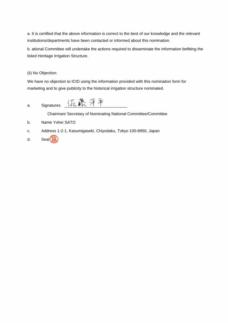
a. It is certified that the above information is correct to the best of our knowledge and the relevant
institutions/departments have been contacted or informed about this nomination.
b. ational Committee will undertake the actions required to disseminate the information befitting the
listed Heritage Irrigation Structure.
(ii) No Objection:
We have no objection to ICID using the information provided with this nomination form for
marketing and to give publicity to the historical irrigation structure nominated.
a. Signatures ____________________________
Chairman/ Secretary of Nominating National Committee/Committee
b. Name Yohei SATO
c. Address 1-2-1, Kasumigaseki, Chiyodaku, Tokyo 100-8950, Japan
d. Seal

Location map
Main canal
Ogawazeki irrigation canal
Branch canals
Beneficial areas
Legends

Attachment of national nomination form ofheritage irrigation structures
“Ogawazeki irrigation canal,” Kanra Town, Gunma
Ogawazeki irrigation canal, water intake (large gate)
Fukiage stone gutter
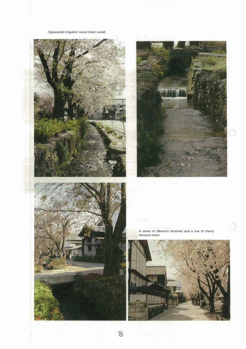
A street of silkworm factories and a row of cherry blossom trees
Ogawazeki irrigation canal (main canal)
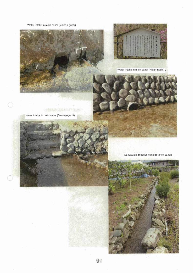
Water intake in main canal (Ichiban-guchi)
Water intake in main canal (Niban-guchi)
Water intake in main canal (Sanban-guchi)
Ogawazeki irrigation canal (branch canal)

“Rakuzanen,” a national scenic spot
Obata Residence in castle town
Tomb of seven heirs of heads ofOda Family

From Ogawazeki irrigation canal to paddy fields in the northern area of Kanra

Old Ogawazeki irrigation canal (main canal)

Nosei No. 30054-3
June 23, 2014
Mr. Yohei Sato, Chairman
Japanese National Committee of the ICID
Opinion
I hereby state that the facility referred to in the application has historical value, that
the entire community is involved in its preservation, and that the condition of the
existing facility is good. I therefore support its application for heritage irrigation
structure status.
Name: Ogawazeki Irrigation Canal
Location: Kanra-machi, Kanra-gun, Gunma Prefecture
Owner: Kanra Town
Masaaki Osawa
(Rural Development Section)
Contact:
Takashi Oshima
Planning official
Rural Development Section
Agricultural Policy Department
Gunma Prefecture