Tolerating Byzantine Faults in Database Systems using Commit Barrier Scheduling

Δελτίο της Ελληνικής Γεωλογικής Εταιρίας, τομ. XLVII , 2013 Πρακτικά 13ου Διεθνούς Συνεδρίου, Χανιά, Σεπτ. 2013
Bulletin of the Geological Society of Greece, vol. XLVII 2013 Proceedings of the 13th International Congress, Chania, Sept. 2013
NOAFAULTS: A DIGITAL DATABASE FOR ACTIVE FAULTS IN GREECE
Ganas A.1, Oikonomou I. A. 1 and Tsimi C.1
1 1Institute of Geodynamics, National Observatory of Athens, Lofos Nymfon, Thission 11810
Athens, Greece, [email protected] [email protected] [email protected]
Abstract
This paper documents the approach to compiling a digital database of fault geome-try and additional attributes primarily to support seismicity monitoring at the Na-tional Observatory of Athens (NOA). A database for Greek active faults has been constructed from published fault maps in peer-reviewed journals since 1972. The standard commercial software ARC GIS has been used to design and populate the database. The fault layer was produced by on-screen digitization and is available to the scientific community in ESRI shapefile (SHP) and TXT formats in WGS84 pro-jection. A KML file is also available to display the fault data in an Earth browser such as Google Earth. In this version of the database, we focus our attention to the active faults of the upper (Aegean + Eurasian) plate and the back-arc region of the Hellenic Arc, in general. 963 faults are included. The database is freely accessible from the Internet. Key words: Active faults, GIS, Hellenic Arc.
Περίληψη
Στην εργασία παρουσιάζεται η μεθοδολογία ανάπτυξης της ψηφιακής βάσης δεδομένων για τα ενεργά ρήγματα της Ελλάδος. Τα ρήγματα προέρχονται από χάρτες δημοσιευμένους σε περιοδικά με κριτές από το 1972. Όλα τα ρήγματα ψηφιοποιήθηκαν σε περιβάλλον ArcGIS και σχηματίστηκε βάση δεδομένων με τα χαρακτηριστικά της γεωμετρίας τους, ρυθμού ολίσθησης και σεισμικής συμπεριφοράς (τελευταίο σεισμικό γεγονός, άλμα κλπ) για όσα ρήγματα βρέθηκαν στοιχεία. Συνολικά περιλαμβάνονται 963 ενεργά ρήγματα. Η βάση διατίθεται ελεύθερα στην επιστημονική κοινότητα. Λέξεις κλειδιά: Ενεργά Ρήγματα, GIS, Ελληνικό τόξο.
1. Introduction Greece is well known in the geosciences for its active tectonics and accompanying seismicity (e.g. Skouphos, 1894; Maravelakis, 1943; Papazachos and Delibasis, 1969; McKenzie, 1978; Delibasis et al., 1981; Mariolakos et al., 1981; Mercier et al., 1983; Pavlides and Mountrakis, 1987; Mariolakos et al., 1989; Ambraseys and Jackson, 1990; Roberts and Jackson, 1991; Taymaz et al., 1991; Doutsos and Poulimenos, 1992; Armijo et al., 1992; Caputo and Pavlides, 1993; Jackson, 1994; Roberts and Ganas, 2000; Lekkas, 2001; Goldsworthy et al., 2002; Caputo et al., 2010; Figure 1). A search on the ISI Web of knowledge database (during March 2013) for Greece AND active faults produced 458 papers for the period 1970-present. Almost every single paper refers to
XLVII, No 2 - 518

an active fault, providing some information on its geometry, kinematics and/or earthquake potential. Yet, a complete active fault database in digital form is missing for this country.
Figure 1 - Relief map of the Hellenic Arc and the Aegean Sea. The surface trace of the Hel-
lenic Arc is shown as adapted after Kreemer and Chamot-Rooke (2004). Also shown are large faults – plate boundaries (North Anatolian Fault - CTF stands for Cephalonia Trans-form Fault), GPS vectors and selected earthquake focal mechanisms from the Global CMT database http://www.globalcmt.org / (compressional quadrants are shown in green). Image
after Ganas and Parsons (2009).
We present first results of a project which stems from the everlasting need to construct seismicity maps containing accurate traces of faults (neotectonic and/or active) for routine seismic monitoring at NOA. During co-seismic and early post-seismic phase (24 hrs) there is a growing pressure by scientists, engineers, politicians and the media to associate earthquake epicentres with faults or faultlines. This is because we have identified two main hazards associated with active faults: ground rupture and ground shaking associated with the rupture. While ground rupture affects only the area in the immediate vicinity of the fault, the ground shaking will impact a much larger area. Existing maps in Greece (e.g. Delibasis et al, 1981; IGME, 1989; Papazachos et al., 2001) can be used for synoptic views because of their small scale (1:275000 or smaller). The Earthquake Planning and Protection Organisation of Greece (EPPO; www.oasp.gr) has published a series of 1:100000 neotectonic map sheets (ten sheets as of June 2013), only in hard copy. The
XLVII, No 2 - 519

Greek Database of Seismogenic Sources (Gre.Da.S.S.) was presented by Pavlides et al., (2008) and Pavlides et al., (2010), focused on the North Aegean region and by Caputo et al., (2012) and Sboras (2012) on northern Greece.
Recently, large-scale (equal to or greater than 1:50000) maps of active faults are required by the Greek Ministries of Environment and Infrastructure in order for city plan expansion to be approved (e.g. Ganas et al., 2010). Most major cities of Greece like Athens, Thessaloniki, Patras and Heraklion host large ports and airports, refineries, large industrial plants, gas pipelines etc which are infrastructures of high economic importance. According to the current Building Code of Greece (EAK, 2000) and to Eurocode 8 regulations (EC-8, 2002) active faults need to be taken seriously in consideration in city planning and infrastructure projects. For the purposes of this study we consider faults as active if they show geologic evidence for slip during the last 125000-130000 years. As geologic evidence we consider published maps or reports or cross-sections documenting displacement of Holocene – late Pleistocene deposits and/or landforms. A longer time period than the Holocene is more appropriate, especially since most earthquake recurrence intervals along intra-plate faults are thousands to tens of thousands of years (see Crone et al., 1997, and Machette, 2000 for the paleoseismic perspective). Also, this age limit is followed by many countries (USA – WSSPC 1997, AIST Japan, New Zealand etc; see reference section for government sources). We also include offshore faults with seismological evidence for their activity during instrumental times (e.g. the 2001 Skyros earthquake fault, Benetatos et al., 2002).
In terms of active tectonics in Greek territory and its boundaries we may distinguish two major settings: the Hellenic Arc and the Greek mainland including the Aegean Sea and parts of western Anatolia (Figure 1). The Hellenic Arc defines a plate boundary between Eurasia and Africa lithospheric plates (Nubia; Ganas and Parsons, 2009 and references there in). We will not consider faults or fault segments along the plate interface as no consensus neither exist on the extent of past ruptures or on the degree of seismic coupling (see papers by Laigle et al., 2002, 2004; Ganas et al., 2009; Shaw and Jackson, 2010) along the arc. Therefore, we focus this first version of the database to the upper plate. The upper plate comprises the provinces of Central Greece, Macedonia, Thrace, Epirus, Peloponnese, Cyclades, Crete and Dodecanese. The latter two lie in a prominent position in the fore-arc of the Hellenic Subduction Zone where large, shallow earthquakes are most likely to occur by normal and strike-slip faulting (e.g. Delibasis et al., 1981; Armijo et al., 1992; Ganas and Parsons, 2009; Caputo et al., 2010). The upper crust of the fore-arc region displays numerous evidence of extensional deformation along both arc-parallel, high-angle, E-W striking faults and along arc-normal, high-angle pure-normal and oblique-normal faults that strike on average N-S. Other sets of normal faults striking NW-SE and NE-SW occur as well. The Greek mainland also deforms by normal faulting (e.g. Ambraseys and Jackson, 1990; Roberts and Jackson, 1991; Doutsos and Poulimenos, 1992; Piccardi, 2000; Kokkalas et al., 2007) while strike-slip tectonics prevail in the central and north Aegean Sea (Taymaz et al., 1991; Koukouvelas and Aydin, 2002).
2. Material and Methods 2.1. Identification of Faults The digitized faults were identified and selected from literature sources, mainly published papers in peer-review journals. These papers were published during the period 1970-2010 and contain fault maps of active faults at a variety of scales. The majority of faults show normal-slip kinemat-ics. The parameterization of the faults includes typical elements such as geometry, kinematics, evidence for activity etc (Table 1). The geological setting of the fault was determined according to Papanikolaou (1989) in most cases. The fault attributes were inserted into an Excel spreadsheet containing the main characteristics of each structure (geometry, kinematics) and were imported to the ARCGIS v 9.3. Number of active faults included in the database: 963.
To design and parameterize the fault database we followed the template produced under the EU project COST 625 (2000-2006; http://fir.seismology.hu/cost625/index.html )
XLVII, No 2 - 520

2.2. Method of Work The working method comprises the following stages: a) scanning of the fault map included in the selected publication in TIFF format (e.g. Figure 2 showing fault traces in north Parnitha region, central Greece; Figure 3 shows a field photograph of the fault surface) b) georeferencing of the scanned raster (TIFF) image using ArcGIS v9.3 software c) digitization of the fault traces as ESRI shapefiles (SHP) d) editing of the attribute table using published information such as fault length, dip direction, dip angle, slip rate etc (Figure 4).
Table 1 - Fault attributes contained in the NOAFaults database. Parameter Type Description Fault code Number Fault number Fault name Text Name of structure Kinematics Text Normal/Reverse/Strike slip sinistral /Strike slip dex-
tral Geological Setting Text Isopic zone of the Hellenides Location Reliability Text At mapping scale: (1:50000 and above) is precise.
(1:50000<scale<1:250000) is approximate. (1: 250000 and below) or map scale taken from seismo-logical data is inferred.
Monitoring Text Description of possible monitoring networks. Paleoseismology Text Description of possible paleoseismological studies. Creep Text Yes/No Co-seismic slip (m) Text Yes/No Notes Text If necessary Activity reliability Text Proven (from trench or seismic rupture) / Very Like-
ly (from geomorphological criteria, or microseismic activity) / Possible (from orientation of structure with respect to the current stress field).
Slip rate (mm/yr) Number If known Instrumental Seismicity Text Yes/No Historical Seismicity Number Yes/No Seismic Events Text List of earthquakes attributed to this fault Max Magnitude Number Maximum recorded magnitude (Ms or Mw) Risk level Text Crossing or in the vicinity (5 km) of towns - hazard-
ous facilities (refineries etc). Low if fault length is less than 1 km. Medium if 1km <fault length <5km. High if fault length is more than 5 km.
Study quality Text Detailed/To be improved Notes Text If necessary Figure Number Figure with digitized faults (from original paper) References Text Author(s) and title of paper(s) Compiler Text Name of the compilers
The following control layers were used i) a vector (SHP format; standard industry format) file of the coastline of Greece at the scale of 1:250000 and ii) the longitude-latitude coordinates provided by the original fault map itself, as published in the literature. The coastline layer had the Greek national projection (Photogrammetric Engineering and Remote Sensing, 2002). All maps based on the coastline control layer were re-projected to geographic coordinates in WGS84. In the second case (based on the original map), we assumed that their geographic coordinates represent tick points under the WGS 1984 ellipsoid. The error of the georeferencing is a function of 1) the poly nomial used in the rectification of each map 2) the original map scale and 3) the quality of the con-
XLVII, No 2 - 521

trol layer. Depending on the scale of the original map we calculated registration errors at the range 12-450 m (the latter error refers to offshore faults).
The digitization of faults took place on-screen using appropriate zooming, paying attention to all fault geometry details provided by the authors. Each fault segment is represented by a vector fea-ture of the database. Then, characteristics of the fault segment such as fault strike, dip, rake, length, slip rate, co-seismic displacement etc were added to the appropriate fields in the database. Individ-ual SHP files were converted to TXT (ASCII) files and then were grouped in 1 set to facilitate fur-ther processing.
Figure 2 - Geological map showing the Maliza active fault in central Greece (after Ganas et
al., 2004). Stereonets show results from slip data collection localities.
Figure 3 - Field photograph of the Maliza active fault (locality N5 on the map in Fig. 2). View
to the south.
XLVII, No 2 - 522
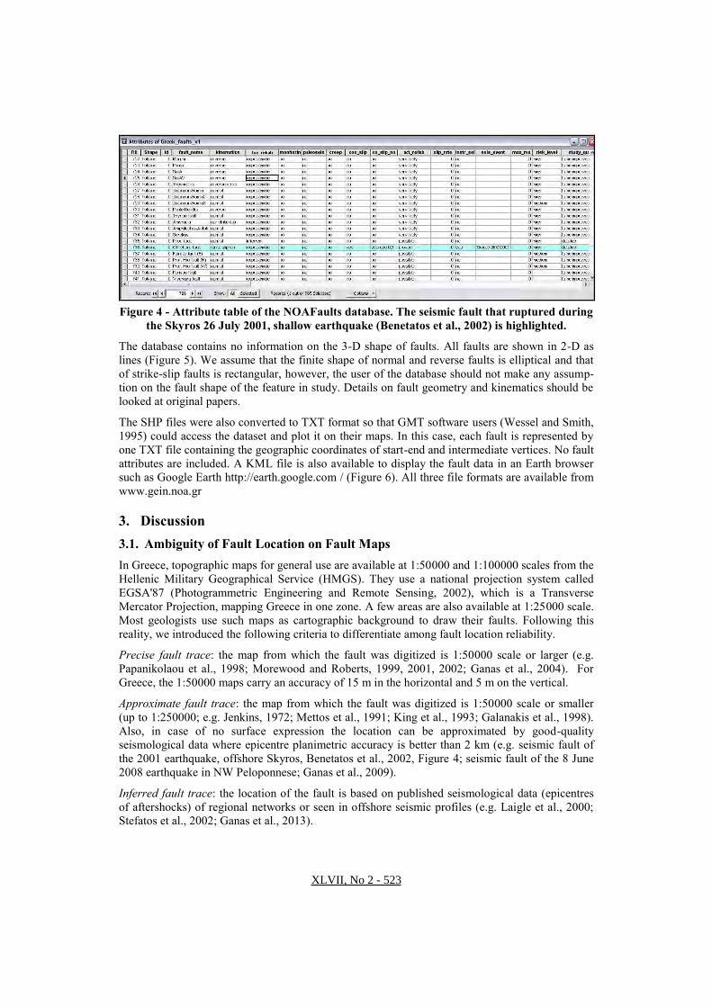
Figure 4 - Attribute table of the NOAFaults database. The seismic fault that ruptured during
the Skyros 26 July 2001, shallow earthquake (Benetatos et al., 2002) is highlighted. The database contains no information on the 3-D shape of faults. All faults are shown in 2-D as lines (Figure 5). We assume that the finite shape of normal and reverse faults is elliptical and that of strike-slip faults is rectangular, however, the user of the database should not make any assump-tion on the fault shape of the feature in study. Details on fault geometry and kinematics should be looked at original papers.
The SHP files were also converted to TXT format so that GMT software users (Wessel and Smith, 1995) could access the dataset and plot it on their maps. In this case, each fault is represented by one TXT file containing the geographic coordinates of start-end and intermediate vertices. No fault attributes are included. A KML file is also available to display the fault data in an Earth browser such as Google Earth http://earth.google.com / (Figure 6). All three file formats are available from www.gein.noa.gr
3. Discussion 3.1. Ambiguity of Fault Location on Fault Maps In Greece, topographic maps for general use are available at 1:50000 and 1:100000 scales from the Hellenic Military Geographical Service (HMGS). They use a national projection system called EGSA'87 (Photogrammetric Engineering and Remote Sensing, 2002), which is a Transverse Mercator Projection, mapping Greece in one zone. A few areas are also available at 1:25000 scale. Most geologists use such maps as cartographic background to draw their faults. Following this reality, we introduced the following criteria to differentiate among fault location reliability.
Precise fault trace: the map from which the fault was digitized is 1:50000 scale or larger (e.g. Papanikolaou et al., 1998; Morewood and Roberts, 1999, 2001, 2002; Ganas et al., 2004). For Greece, the 1:50000 maps carry an accuracy of 15 m in the horizontal and 5 m on the vertical.
Approximate fault trace: the map from which the fault was digitized is 1:50000 scale or smaller (up to 1:250000; e.g. Jenkins, 1972; Mettos et al., 1991; King et al., 1993; Galanakis et al., 1998). Also, in case of no surface expression the location can be approximated by good-quality seismological data where epicentre planimetric accuracy is better than 2 km (e.g. seismic fault of the 2001 earthquake, offshore Skyros, Benetatos et al., 2002, Figure 4; seismic fault of the 8 June 2008 earthquake in NW Peloponnese; Ganas et al., 2009).
Inferred fault trace: the location of the fault is based on published seismological data (epicentres of aftershocks) of regional networks or seen in offshore seismic profiles (e.g. Laigle et al., 2000; Stefatos et al., 2002; Ganas et al., 2013).
XLVII, No 2 - 523
Figure 5 - Map of active faults of Greece (green lines) contained in NOAFaults database over
a raster DEM (ETOPO2, 2004) in geographic projection. Faults are shown without kine-matic information. Higher elevations are shown in bright tones of grey. Blue crosses are half-
degree ticks.
3.2. Ambiguity on Fault Activity Reliability We introduced the following criteria to differentiate among fault activity reliability:
Proven activity as demonstrated by reported co-seismic displacement along the fault trace during large earthquakes (e.g. Pavlides and Tranos, 1991; Pavlides et al., 1995; Ambraseys and Jackson, 1998), including the age of last motion measured in paleoseismological trenches (e.g. Heliki fault in Peloponnese, Koukouvelas et al., 2001; Atalanti fault in central Greece; Pantosti et al., 2004; Kaparelli and Mygdonia faults in Chatzipetros et al., 2005). Other evidence of present activity includes displacement of Holocene-Late Pleistocene sedimentary deposits and/or Middle-Late
XLVII, No 2 - 524

Figure 6 - Google Earth Image (September 2011 version) showing traces of active faults
(purple lines). Faults shown are those of the upper (Aegean) plate.
Pleistocene sedimentary deposits (e.g. Caputo, 1996; Ganas, 1997; Maroukian et al., 2000; Goldsworthy and Jackson, 2001).
Activity Very likely as demonstrated by a) microseismic activity aligned for several kilometres for half- to two fault lengths as seen on seismicity maps (e.g. Louvari et al., 1999; Ganas et al., 2009), b) geological indicators (bean-shaped basins filled with Neogene syn-rift etc; e.g. Roberts and Ganas, 2000) and c) geomorphologic indicators (systematically displaced streams and erosion surfaces, existence of triangular facets along mountain fronts, etc; Papanikolaou et al., 1988; Ganas, 1997; Goldsworthy and Jackson, 2000).
Activity Possible as demonstrated by the orientation (strike) of fault with respect to the current stress field (e.g. offshore faults along the Hellenic Arc; Mascle et al., 1982; Hatzfeld et al., 1990), and/or by faults located near sharp discontinuities on GPS profiles (e.g. faults reported by Underhill, 1988, onshore Zakynthos where a GPS profile discontinuity exists in Hollenstein et al., 2008).
3.3. Overlapping Sources of Information Many active faults are included in overlapping maps of the same area by different authors. For example the ISI Web of Knowledge database contains 149 papers on active faults AND Gulf of Corinth (June 2013 search). In such cases, we proceeded with a careful selection of those papers that contain the original fault maps, both onshore and offshore. It is possible that we missed a few
XLVII, No 2 - 525

papers in this research as we could not trace back in literature all published papers. We ask for the understanding of those authors that see their work not mentioned in this database. As we present this product in its preliminary version, we aim to integrate this knowledge in future editions of this database. If possible, we also ask for their inputs by sending original material to the first author in Athens.
3.4. Lack of Consensus There were cases where the fault trace is debatable among various authors, so as a decision had to be made by us. For example, old maps of the Atalanti fault in central Greece (IGME, 1989) show this active fault to reach the town of Agios Konstantinos (about 15 km to the northwest of Atalanti) while newer maps (Ganas, 1997; Ganas et al., 1998; Cundy et al., 2000) show it to terminate near the town of Atalanti. It is unfortunate that this version of the database cannot present all published versions of Greek active faults. Therefore, a disclaimer has been added at the end of this paper cautioning users to probable errors and omissions of this product.
3.5. Future Steps We plan to update the database at regular intervals. Future add-ons may include details on fault geometry (strike, dip angle and dip direction) and kinematics (rake angle, sense of displacement), field photographs of selected fault planes known for hosting large earthquakes, GPS measurements from permanent stations close to major faults, links to on-line sources (libraries, etc), historical seismicity data etc.
We also anticipate that the database may be used in seismic hazard assessments (assuming the active faults as seismic sources) and as a tool for earthquake risk assessment in various parts of Greece. The database is more complete in the regions of central Greece (including Thessaly and Peloponnese), in west and central Macedonia and along the Hellenic Arc. The Hellenic Arc is prone to tsunamis (e.g. Lorito et al., 2008) so the database may be used in tsunami early warning applications. We could not retrieve lots of literature pieces for eastern Macedonia, Thrace and the Aegean Sea, so these areas will become targets for future updates of the database.
4. Conclusions This paper documents the approach to compiling a digital database of fault geometry and additional attributes primarily to support seismic operations at the National Observatory of Athens (NOA).
A first version of the digital database of Greek active faults has been constructed. The database contains 963 faults published in peer-reviewed literature. This product may be used by geologists, seismologists and engineers working with cartographic scales 1:50000 and smaller. We exercise extreme caution to users of the database working with larger scales (e.g. 1:10000). The database is a growing database and will be subject to change as new information becomes available and new maps are published on Greek faults.
5. Acknowledgments Some aspects of this work were funded by Action 625 of the COST project of EU (http://www.cost.esf.org/), by EU project PREVIEW, by ESA project TERRAFIRMA and by the Greek Secretariat for Research and Technology (GSRT), Ministry of Education, Greece. We thank our COST colleagues for the useful exchange of ideas. We are indebted to Spyros Pavlides, Luigi Piccardi, Anastasia Kiratzi, Gerald Roberts, Kevin White, Ricardo Caputo, Stefano Salvi, Vincenzo Spina and Ioannis Koukouvelas for discussions on active faulting and comments during field trips. We also thank Lina Alexandropoulou, Sotiris Valkaniotis and Fotini Kounavi for help with data collection and GIS processing. The paper got useful reviews from A. Chatzipetros and E. Lekkas. The database is freely accessible from the Internet (www.gein.noa.gr ).
XLVII, No 2 - 526

Disclaimer: This digital product is provided by the copyright holders "as is". In no event shall the copyright owner be liable for any direct, indirect, incidental, special, exemplary, or consequential damages as a result of its use.
6. References Ambraseys N. and Jackson J. 1990. Seismicity and associated strain of central Greece between
1890 and 1988, Geophys. J. Int., 101, 663-708. Ambraseys N. and Jackson J. 1998. Faulting associated with historical and recent earthquakes in
the Eastern Mediterranean region, Geophys. J. Int., 133, 390-406. Armijo R., Lyon-Caen H. and Papanastassiou D. 1992. East-west extension and Holocene normal
fault scarps in the Hellenic arc, Geology, 20, 491-494. Benetatos C., Roumelioti Z., Kiratzi A.and Melis N. 2002. Source parameters of the M 6.5 Skyros
island (North Aegean Sea) earthquake of July 26, 2001, Annals of Geophysics, 45, 3-4. Caputo R., Catalano S., Monaco C., Romagnoli G., Tortorici G. and Tortorici L. 2010. Active
faulting on the island of Crete (Greece), Geophysical Journal International, 183, 111–126. Caputo R. and Pavlides S. 1993. Late Cenozoic geodynamic evolution of Thessaly and surround-
ings (central-northern Greece), Tectonophysics, 223(3-4), 339-362. Caputo R. 1996. The active Nea Anchialos Fault System (Central Greece): comparison of geologi-
cal, morphotectonic, archaeological and seismological data, Annali di Geofisica, 39(3), 557-574.
Caputo R, Chatzipetros A., Pavlides S. et al. 2012. The Greek Database of Seismogenic Sources (GreDaSS): state-of-the-art for northern Greece, Annals of Geophysics, 55(5), 859-894.
Chatzipetros A., Kokkalas S., Pavlides S. and Koukouvelas I. 2005. Paleoseismic data and their implication for active deformation in Greece, Journal of Geodynamics, 40, 170-188.
Crone AJ, Machette MN and Bowman J.R. 1997. Episodic nature of earthquake activity in stable continental regions revealed by palaeoseismicity studies of Australian and North American Quaternary faults, Australian Journal of Earth Sciences, 44(2), 203-214.
Cundy A.B., Kortekaas S., Dewez T., Stewart I.S., Kollins P.G., Cruddace I.W., Maroukian H., Papanastasiou D., Gaki-Papanastasiou P., Pavlopoulos K. and Dawson A. 2000. Coastal wetlands as recorders of earthquake subsidence in the Aegean: a case study of the 1894 gulf of Atalanti earthquakes, central Greece, Marine Geology, 170, 3-26.
Delibasis N., Drakopoulos J. K., Fytrolakis N., Katsikatsos G., Makropoulos K.C. and Zamani A. 1981. Seismotectonic Investigation of the area of Crete Island, Proc. of the Intern. Symp. on the Hellenic Arc and Trench (H.E.A.T.), Athens, 1, 121-138.
Doutsos T. and Poulimenos G. 1992. Geometry and Kinematics of active faults and their seismotectonic significance in the Western Corinth-Patras rift (Greece), J. Structural Geol-ogy, 14(6), 689-699.
EC-8 2002. Eurocode 8: Design of structures for earthquake resistance, Part 5: Foundations, re-taining structures and geotechnical aspects, Draft No5, Revised Final Project Team Draft (preStage 49), May 2002, Doc CEN/TC250/SC8/N318.
ETOPO2 2004. Available online at: http://www.ngdc.noaa.gov/mgg/global/relief/ETOPO2/ Galanakis D., Pavlides S.band Mountrakis D. 1998. Recent brittle tectonic in Almyros –
Pagasitikos, Maliakos, N. Euboea & Pilio, Bulletin of the Geological Society of Greece, XXXII/1, 263-273.
Ganas A., Chousianitis K., Batsi E., Kolligri M., Agalos A., Chouliaras G. and Makropoulos K. 2013. The January 2010 Efpalion earthquakes (Gulf of Corinth, Central Greece): earth-quake interactions and blind normal faulting, Journal of Seismology, 17 (2), 465-484.
Ganas A., Palyvos N., Mavrikas G., Kollias S. and Tsimi C. 2010. Geomorphological and geologi-cal observations at the coast of Tripiti hill (Heraklion harbour, Crete), in relation to reported active faulting, Proceedings of XIX CBGA Congress, Thessaloniki, Greece, 99, 11-20.
Ganas A., Serpelloni E., Drakatos G., Kolligri M., Adamis I., Tsimi Ch. and Batsi E. 2009. The Mw 6.4 SW Achaia (Western Greece) Earthquake of 8 June 2008: Seismological, Field,
XLVII, No 2 - 527

GPS Observations, and Stress Modeling, J. of Earthquake Engineering, 13(8), 1101 — 1124.
Ganas A. and Parsons T. 2009. Three-dimensional model of Hellenic Arc deformation and origin of the Cretan uplift, J. Geophysical Research, 114, B06404, doi: 10.1029/2008JB005599.
Ganas A., Pavlides SB., Sboras S., Valkaniotis S., Papaioannou S., Alexandris GA., Plessa A.and Papadopoulos GA. 2004. Active Fault Geometry and Kinematics in Parnitha Mountain, At-tica, Greece, Journal of Structural Geology, 26, 2103-2118.
Ganas A., Roberts G.P. and Memou Tz. 1998. Segment boundaries, the 1894 ruptures and strain patterns along the Atalanti Fault, Central Greece, Journal of Geodynamics, 26(2-4), 461 - 486.
Ganas A. 1997. Fault Segmentation and Seismic Hazard Assessment in the Gulf of Evia Rift, cen-tral Greece, Unpublished PhD thesis, University of Reading, UK, 369pp.
Geological Survey of Japan, AIST, Active fault database of Japan, web site assessed July 1, 2013, Available at http://riodb02.ibase.aist.go.jp/activefault/index_e.html
Goldsworthy M, Jackson J. and Haines J. 2002. The continuity of active fault systems in Greece, Geophys. J. Int. 148, 596 – 618.
Goldsworthy M. and Jackson J. 2000. Active normal fault evolution in Greece revealed by geo-morphology and drainage patterns, Journal of the Geological Society, London, 157, 967-981.
Goldsworthy M. and Jackson J. 2001. Migration of activity within normal fault systems: examples from the Quaternary of mainland Greece, Journal of Structural Geology, 23, 489-506.
Hatzfeld D., Pedotti G., Hatzidimitriou P. and Makropoulos K. 1990. The strain pattern in the western Hellenic arc deduced from a microearthquake survey, Geophys. J. Int., 101, 181-202.
Hollenstein Ch., Muller M.D., Geiger A. and Kahle H.G. 2008. Crustal motion and deformation in Greece from a decade of GPS measurements, 1993-2003, Tectonophysics, 449(1-4), 17-40.
IGME 1989. Seismotectonic map of Greece with seismogeological data, 1 map on 4 sheets, 1:500000 scale.
ISI web of knowledge: Available at http://isknowledge.com Copyright © 2013 Thomson Reuters Jackson J. 1994. Active tectonics of the Aegean region, Annual Review of Earth and Planetary
Sciences, 22, 239-271. Jenkins D.A. 1972. Structural development of Central Greece, The American association of Petro-
leum Geologists Bulletin , 56(1), 128-149. King G., Sturdy D. and Whitney J. 1993. The landscape geometry and active tectonics of north-
west Greece, Geological Society of America Bulletin, 105, 137-161. Kokkalas S., Pavlides S., Koukouvelas I., Ganas A. and Stamatopoulos L. 2007. Paleoseismicity
of the Kaparelli fault (eastern Corinth Gulf): Evidence for earthquake recurrence and fault behavior, Bollettino della Societa Geologica Italiana, 126 (2), 387-395.
Koukouvelas I. K.and Aydin A. 2002. Fault structure and related basins of the North Aegean Sea and its surroundings, Tectonics,.21(5), 1046, doi: 10.1029/2001TC901037.
Koukouvelas I.K., Stamatopoulos L., Katsonopoulou D. and Pavlides S. 2001. A palaeoseismological and geoarchaeological investigation of the Eliki fault, Gulf of Corinth Greece, Journal of Structural Geology, 23, 531-543.
Kreemer C. and Chamot-Rooke N. 2004. Contemporary kinematics of the southern Aegean and the Mediterranean Ridge, Geophysical J. International, 157, 1377-1392.
Laigle M., Hirn A., Sachpazi M. and Roussos N. 2000. North Aegean crustal deformation: An ac-tive fault imaged to 10 km depth by reflection seismic data, Geology, 28(1), 71-74.
Laigle M., Hirn A., Sachpazi M. and Clément C. 2002. Seismic coupling and structure of the Hel-lenic subduction zone in the Ionian Islands region, Earth and Planetary Science Letters, 200 (3-4), 243-253.
Laigle M., Sachpazi M. and Hirn A. 2004. Variation of seismic coupling with slab detachment and upper plate structure along the western Hellenic subduction zone, Tectonophysics, 391(1-4), 85-95.
XLVII, No 2 - 528

Lekkas E. 2001. The Athens earthquake (7 September 1999): intensity distribution and controlling factors, Engineering Geology, 59, 297-311.
Lorito S.,Tiberti M.M, Basili R., Piatanesi A. and Valensise G. 2008. Earthquake-generated tsu-namis in the Mediterranean Sea: Scenarios of potential threats to Southern Italy, J. Geophys. Res., 113, B01301, doi:10.1029/2007JB004943.
Louvari E., Kiratzi A.A. and Papazachos B.C. 1999. The Cephalonia Transform fault and its ex-tension to western Lefkada Island (Greece), Tectonophysics, 308, 223-236.
Machette M.N. 2000. Active, capable, and potentially active faults - a paleoseismic perspective, Journal of Geodynamics, 29(3-5), 387-392.
Maravelakis M.J. 1943. Geologic and macroseismic study of the devastated earthquake of Larisa of 1 March 1941. Triakontapentaeteris of Prof. N. Criticos, Athens, 2, 176-193 (in Greek).
Mariolakos I., Fountoulis I., Logos E. and Lozios S. 1989. Surface faulting caused by the Kalamata (Greece) earthquakes (13/9/86), Tectonophysics, 163, 197 - 203.
Mariolakos I., Papanikolaou D., Symeonidis N., Lekkas S., Karotsieris Z. and Sideris C. 1981. The deformation of the area around the eastern Corinthian Gulf affected by the earthquakes of February to March 1981, Proc. Int. Symp. Hellenic Arc and Trench, Athens, 400–420.
Maroukian H., Gaki-Papanastassiou K., Papanastassiou D. and Palyvos N. 2000. Geomorphologi-cal Observations in the coastal zone of Kyllini Peninsula, NW Peloponnesus – Greece, and their relation to the seismotectonic regime of the area, J. Coastal Research 16(3), 853-863.
Mascle J., Le Quellec P., Leite O. and Jongsma D. 1982. Structural sketch of the Hellenic conti-nental margin between the western Peloponnesus and eastern Crete, Geology, 10,113-116.
McKenzie D. 1978. Active tectonics of the Alpine-Himalayan belt: the Aegean Sea and surround-ing regions, Geophys. J.R. Astr. Soc., 55, 217-254.
Mercier J.L., Carey-Gailhardis E., Mouyaris N., Simeakis K., Roundoyannis T. and Anghelidhis C. 1983. Structural analysis of recent and active faults and regional state of stress in the epicentral area of the 1978 Thessaloniki earthquakes (northern Greece), Tectonics, 2(6), 577-600.
Mettos A., Rontogianni Th., Papadakis G., Paschos P., Georgiou Ch. 1991. New geological data of the Neogene deposits of N. Euboea, Bulletin of the Geological Society of Greece, XXV/3, 71-83.
Morewood N.C. and Roberts G.P. 1999. Lateral propagation of the surface trace of the south Alkyonides normal fault segment, central Greece: its impact on models of fault growth and displacement – length relationships, Journal of Structural Geology, 21, 635-652.
Morewood N.C. and Roberts G.P. 2001. Comparison of surface slip and focal mechanism slip data along normal faults: an example from the eastern Gulf of Corinth, Greece, Journal of Struc-tural Geology, 23, 473-487.
Morewood N.C. and Roberts G.P. 2002. Surface observations of active normal fault propagation: implications for growth, Journal of the Geological Society London, 159, 263-272.
New Zealand Ministry for the Environment (available on June 2013, web access) http://www.mfe.govt.nz/publications/rma/planning-development-active-faults-dec04/html/page11.html
Pantosti D., De Martini P.M., Papanastassiou D., Lemeille F., Palyvos N. and Stavrakakis G. 2004, Paleoseismological trenching across the Atalanti fault (Central Greece): evidence for the ancestors of the 1894 earthquake during the Middle Ages and Roman times, Bulletin of the Seismological Society of America, 94(2), 531-549.
Papanikolaou D. I., Mariolakos H. D., Lekkas E. L. and Lozios S.G. 1988. Morphotectonic obser-vations on the Asopos basin and the coastal zone of Oropos. Contribution to the neotectonics of Northern Attica, Bulletin of the Geological Society of Greece, XX, 251-267.
Papanikolaou D., Vassilakis E. and Parcharidis I. 1998. Satellite images of short wavelength radia-tion for structure detection in shallow waters case study: Aegina – Agistri islands, Saronikos gulf, Bulletin of the Geological Society of Greece , XXX/1, 105-111.
Papanikolaou D. 1989. Geotectonic map of Greece. Special Publ. No 1, in Papanikolaou & Sassi eds., Geol. Soc. Greece - IGCP project 276, Newsletter No 1, Athens.
XLVII, No 2 - 529

Papazachos B.C, and Delibasis N.D. 1969. Tectonic stress field and seismic faulting in the area of Greece, Tectonophysics, 7(3), 231-255.
Papazachos B. C.,Mountrakis D.M., Papazachos C.B., Tranos M.D., Karakaisis G.F. and Savvaidis A.S. 2001, The faults that caused the known strong earthquakes in Greece and surrounding areas during 5th century B.C. up to present, Proc. 2nd Conf. Earthquake Eng. and Eng. Seism., Thessaloniki, Greece, 1, 17–26.
Pavlides S.B. and Mountrakis D.M. 1987. Extensional tectonics of north-western Macedonia, Greece, since the late Miocene, Journal of Structural Geology, 9(4), 385-392.
Pavlides S.B. and Tranos M.D. 1991. Structural characteristics of two strong earthquakes in the North Aegean: Ierissos (1932) and Agios Efstratios (1968), Journal for Structural Geology, 13(2), 205-204.
Pavlides S.B., Zouros N.C, Chatzipetros A.A., Kostopoulos D.S. and Mountrakis D.M. 1995. The 13 May 1995 western Macedonia, Greece (Kozani Grevena) earthquake; preliminary re-sults, Terra Nova, 7, 544–549.
Pavlides S., Valkaniotis S. and Chatzipetros A. 2008. Seismically capable faults of Greece and their use in seismic hazard assessment, Proceedings of the 4th International Conference on Earthquake Geotechnical Engineering, Thessaloniki, 25-28 June 2007, Paper 1609.
Pavlides S., Caputo R., Sboras S., Chatzipetros A., Papathanasiou G. and Valkaniotis S. 2010. The Greek Catalogue of Active Faults and Database of Seismogenic Sources, Bulletin Geologi-cal Society of Greece, XLIII/1, 486-494.
Photogrammetric Engineering and Remote Sensing, Grids and Datums, December 2002. Available at: http://www.asprs.org/resources/Grids/12-2002-hellenic.pdf
Piccardi L. 2000. Active fault at Delphi, Greece: Seismotectonic remarks and a hypothesis for the geologic environment of a myth, Geology, 28(7), 651-654.
Roberts G. P. and Ganas A. 2000. Fault-slip directions in central and southern Greece measured from striated and corrugated fault planes: Comparison with focal mechanism and geodetic data, Journal of Geophysical Research, 105(B10), 23443-23462.
Roberts S. and Jackson J. 1991. Active normal faulting in Central Greece: an overview. In: Rob-erts A. M., Yielding G. & Freeman B. eds., The geometry of normal faults, Geological So-ciety London Publication, 56, 125-142.
Sboras S. 2012. The Greek Database of Seismogenic Sources: seismotectonic implications for North Greece, PhD Thesis, University of Ferrara, Ferrara, 252 pp.
Shaw B. and Jackson J. A. 2010. Earthquake mechanisms and active tectonics of the Hellenic subduction zone, Geophysical Journal International, 181(2), 966-984.
Skouphos T. 1894. Die swei grossen Erdbeben in Lokris am 8/20 und 15/27 April 1894, Zeitschrift Ges. Erdkunde zu Berlin, 24, 409-474.
Stefatos A., Papatheodorou G., Ferentinos G., Leeder M. and Collier R. 2002. Seismic reflection imaging of active offshore faults in the Gulf of Corinth: their Seismotectonic significance, Basin Research, 14, 487-502.
Taymaz T., Jackson J. and McKenzie D. 1991. Active tectonics of the north and central Aegean Sea, Geophys. J. Int., 106, 433-490.
Underhill J. R. 1988. Triassic evaporates and Plio-quaternary diapirism in Western Greece, Jour-nal of the Geological Society, London, 145, 269-282.
Wessel P. and Smith W.H.F. 1995. New Version of the Generic Mapping Tools Released, EOS Trans. AGU, 76, 329.
WSSPC (Western States Seismic Policy Council), 1997. Active fault definition for the Basin and Range Province, WSSPC Policy Recommendation 97-1 White Paper, May 22, 1997, San Francisco, CA. p. 3.
XLVII, No 2 - 530