no IiiIIJIhhhhEEE Il-rn-Eomml. flfll*essfflflf · Figure 8. 1890 Plat and Highway Construction 40...
185
AD-"i 766 MCHEOLOICRL 0D NISTSRICIL IWYESTURTZU5S OLD FOSTN 1/2 SITIE (22TA41) TOL. (U) ARCNEOLOIC.L ASSESSHMIS rn ~~~~WWZSFE IWLLE M N 4 KUIETT ET AL. KC 97 IUSF CEOLIC S SSS S IS 5/6 6L no IiiIIJIhhhhEEE Il-rn-Eomml. I flfll*essfflflf
Transcript of no IiiIIJIhhhhEEE Il-rn-Eomml. flfll*essfflflf · Figure 8. 1890 Plat and Highway Construction 40...

AD-"i 766 MCHEOLOICRL 0D NISTSRICIL IWYESTURTZU5S OLD FOSTN 1/2SITIE (22TA41) TOL. (U) ARCNEOLOIC.L ASSESSHMIS rn
~~~~WWZSFE IWLLE M N 4 KUIETT ET AL. KC 97IUSF CEOLIC S SSS S IS 5/6 6L
no IiiIIJIhhhhEEEIl-rn-Eomml.I flfll*essfflflf

J2.
3132
I"a
LI 36111 11 ,
1.25
.OF r
-D/ # i
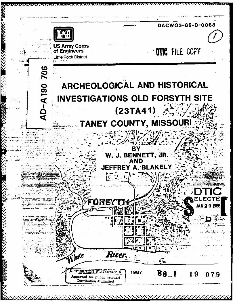
"p DACW3-86-D-0068
US Army Corps-of Engineers icFL u
___Little Rock District
o ARCHEOLOGICAL AND HISTORICALINVESTIGATIONS OLD FORSYTH SITE
(23TA4 1)___A TANEY COUNTY,
f. v. 4L
6 - - BY.~~ W.J. BENNETT,:-JR.4
I'v. AND~ ~ JEFFREY A. BLAKELY -.,-,-
T -
r N~ DTIC'ELECTEJAN2 9 IM8
See _____
r - j- 7 -
DiatributioL -Unimt
198p..

SECURITY CLASSIPICATIOn Of THIS 9_________READ ____________
REPORT DOWU O-..A RE COMPLETNG FORM) ~ .REPOT wumER .. JIENT'S CATALOG M6UNSER
Delivery Order No.. 6.4. TTLEa~Ma.)--. 5.Type OF REPORT 6 PERIOD COVCm9Z
Archeologica. an d Historical Investigations at theOld Forsyth Site (23TA4l) Tahtey County, -issouri 6.- PERFORMING ORG. REPORT NUMBER
V. AUTHOR~a) IL CONTRACT OR GRAN4T NUUUER(a)
W.J. Bennett-, Jr. and Jeffrey A. Blakely DACW3-86-D-0068
9. PERFORMING ORG6ANIZATION HAMS AND ADDRESS 10. PRO4GRAM ELEMENT. PROJECT. TASKAR, CA & ORKC UNIT NUMBERS
Archeological Assessments, Inc. Cultural Resources ManagemenP.O. Box 1631 Operation and MaintenanceNashville- Ark- 71892 SWL-PL-A
St. CON4TROLLS G OFFICE NAME AND ADDRESS IS. RCPORT OAT&
U .S. Army Engineer District, Little Rock (SWL-PL-A December 1987P.O. Box 867 is. MUMMER OF PAGESLittle Rock, Ar. 72203-867 174
14. MONITORING AGENCY NAUL 6 AOORESSU dlhm*1011 61111 GumW081 09800) IS. SELCURITY CLASS. (al two p..4J
unclassifiedIS.OECLASStFICATIORIOOWMGRAOING
SCNEOULa
16. DISTRIBUTION STATEMENT (iat RIN&APeN
Approved for public release ----
IT =TOUONEATINU fg AA6069=81141dAm ftk *X rb~4mqw*
~~ 1SL SUPPLEMNTAXT NOTE"
I9. KCEY WORDS (Caimam.. avI geminw ulds is solese*W 1ud IdmIy aee"inN
*Old Forsyth Archaic Compofiint National Register townWhite River Ozark Mountains Historic ArcheologySwan Creek Taney County
irCivil War Bull Shoals Lake
20. ANSTRAC (ComiMimioi peyee ide U aecae mu m"Oddy lby eak esmube)
A programi of site evaluation was carried out at the site of Old Forsyth, 23TA41e ~Taney County, Missouri. The goal1 of the effort was to provile information
regarding the site's historical context and to document the nature of thearcheological deposits at the site in support of a nomination of the site tothe National Register of Historic Places. The site, which is presently withinthe US Army Corps of Engineers Public Use Area, Shadow Rock Park, has beenextensively modified since its original settlement in the early decades of the19th century. Situated at the Rvp g-"~~ rtl TTh4te Rive-.
DO ,*M" 1473 EDITION OF I NOV 111 19 OBSOLIETEt
SCCURTV CLASSIFICATION Of THIS PAGE f*%.e. Data E......E)

Forsyth was a major commercial site for the development of southwest Missouri
prior-to the-Civil War and became the county seat for Taney County in 1845.It was the location of several skirmishes during the Civil War and destroyedas part of a Federal operation in 1863.7-The town vas rebuilt shortly after.
the Civil War and reestablished itself as an important political and economiccenter within southwest Missouri. The town was removed in the 1950's when
Bull Shoals Lake was created. The site contained an extensive prehistoric
Archaic component in addition to materials related-to its occupation in the19th and 20th centuries.
..... -.-.
.. ao 00n4weJVb SL).-wm to~ -mb 30aft9 WA SX20A TanatTq44- A#
S..
S%
Sa. - S. -
ARCHBOJICAL ASSESSMENTS REPCR1 NO. 66
Archeological and Historical Investigationsat the
Old Forsyth Site(23TA41)
Taney County, Missouri
byW. J. Bennett, Jr.
andJeffrey A. Blakely
Report Submittedto the
US Army Corps of EngineersLittle Rock DistrictLittle Rock, Arkansas
Acce :,on For
. .. c. - . .--
r01987 ~vQ~..X
Distribution Statemecnt A is correct for this jyCod.es
report. orPer Mr. Bob Dunn, U. S. Army Enqineer Dis- .tSidt
trict, Little Rock - _ __ ___

IS
ABSTRACT
A program of site evaluation was carried out at the site of Old Forsyth,23TA041, Taney County, Missouri. The goal of the effort was to provideinformation regarding the site's historical context and to document thenature of the archeological deposits present at the site in support of anomination of the site to the National Register of Historic Places. Thesite, which is presently within the US Army Corps of Engineers Public UseArea, Shadow Rock Park, has been extensively modified since its originalsettlement in the early decades of the 19th century. Situated at theconfluence of Swan Creek and White River, Forsyth was a major cormercialsite for the development of southwest Missouri prior to the Civil War andbecame the county seat for Taney County in 1845. It was the location ofseveral skirmishes during the Civil War and destroyed as part of a Federaloperation in 1863. The town was rebuilt shortly after the Civil War andreestablished itself as an important political and economic center withinsouthwest Missouri. The town was removed in the 1950's whe, Bull ShoalsLake was created. The site contained an extensive prehistoric (Archaic)component in addition to materials related to its occupation in the 19th and20th centuries.
IINS.
,S:

TABLE OF CaIIINTS
Pages
AbstractTable of Contents iiList of Figures iiiList of Tables iv
INTTFJMUlION 1 -3Project Authorization 1Project Area Location 1Project Orientation and Goals 1
PREVIOUS AWCIEOLOGICAL INVESTIGATICQS 4 - 5 S
RBGICNAL CULTIURE-HISTXRICAL Ca= 6 - 14Pre-Euro-American Occupation 6 ,.Historic Period Background 11
DCffVINTARY HISTUtY 15 - 32 r
Methodology 15Pre-European Settlement Activities in the
Vicinity of the Old Forsyth Site 15
Initial European Settlement 16Creation and Early Years of Taney County 19The Plat of Forsyth 211855 Courthouse and Civil War City Plan 23Civil War 25Aftermath 32
SITE PLAN OVERVIEW 33
FIELD INVESTIGATICNS 43 - 94General Strategy 43Site Stratigraphy 44Southeastern Portion of the Site 50Excavations in the Courthouse Square 57Town West of the Courthouse 79The Ice House Locality 90
EURI-AMERICAN ARTIFA-TS 95 - 118Chronology 95Nails 109Glass Window Panes 114
PREHISKTRIC ARTIFACTS 119 - 121
SUTIPMVIY AND C(XCNUSICINS 122 - 123
REFER12CE CITED 124 - 137 S
APPENDICES
IL
, ,%er
ii

List of Figures
Page SFigure 1. Old Forsyth Location Map 2Figure 2. Shadow Rock Park 34Figure 3. Shadow Rock Park 35Figure 4. Early Twentieth Century Forsyth 36Figure 5. Civil War Cartographer's Map 37Figure 6. 1890 Plat and Civil War Period Structures 38Figure 7. 1890 Plat, Civil War Period Structures, and the
Location of Known 1950s Buildings 39Figure 8. 1890 Plat and Highway Construction 40Figure 9. Map of Shadow Rock Park 41Figure 10. 1890 Plat and Shadow Rock Park 42Figure 11. 1890 Plat, Civil War Period Structures, and S
Archeological Excavations 45Figure 12. Profile I (photograph) 46Figure 13. Profile 1 (Schematic Diagram and Soil Description) 47Figure 14. Profile 4 (Schematic Diagram and Soil Description) 48Figure 15. Location of Southeastern Section Excavation Units 51Figure 16. Test Units I South, 2 South, 3 South: Profiles 53Figure 17. 1890 Court House 58Figure 18. Location of Court House Square Excavation Units 59Figure 19. Location of 20th Century Additions to the Court
House Caplex 60Figure 20. Location of Post-1950's Canmemorative Markers 61Figure 21. Block 1, Unit 10: Profile 63 1.Figure 22. Foundation of 1911 Extention to the Court House:
Block 4, Unit 22 64Figure 23. Flue Box footing: Block 6, Unit 25 65Figure 24. Upper Level of Water Line Ditch: Block 7, Unit 21 66Figure 25. Rest Roam Complex Water Line: Block 7, Unit 21 66Figure 26. Top of Double Foundation: Block 26, Unit 5 67Figure 27. Rubble inside the Double Foundation: Block 26, Unit 9 67Figure 28. Block 27, Unit 1: North Profile and Photograph 69Figure 29. Block 27, Unit 1: South Profile and Photograph 70Figure 30. Block 26, Unit 9: Foundation Trench Profile 71Figure 31. Location of Shovel Tests 80Figure 32. Location of Ice House Area Test Units 91Figure 33. Photographs of the Ice House 92Figure 34. Ice House Test Units 1, 2, 3: Profiles 93Figure 35. Glass Artifacts 100Figure 36. Ceramic Artifacts 101Figure 37. Metal Artifacts 102Figure 38. Lithic Artifacts 121
iii

List of Tables
Page
Table 1. Chronological Framework 6Table 2. Euro-American Historic Artifacts Recovered from
Test Units 1, 2, and 3 South 55Table 3. Euro-American Historic Artifacts Recovered from
Courthouse Square 72Table 4. Shovel Test: Euro-American Artifacts and Stratigraphy 81Table 5. Euro-American Artifacts Recovered from Icehouse Test
Units 1, 2, and 3 94Table 6. Chronologically Diagnostic Materials 95Table 7. Chronological Range of Euro-American Artifacts 103Table 8. Distribution of Euro-American Ceramics 104Table 9. Length of Standard Nail Sizes 107Table 10. Square-cut Nails: Length 109Table 11. Wire Nails: Length 112Table 12. Window Pane Thickness and Chronology 116Table 13. Horizontal Distribution of Window Glass Panes 117Table 14. Distribution of Window Glass Panes in Selected
Proveniences 118Table 15. Dart Points 120
* ,..
'i
AeK
V
lv 6

Archeological and Historical Investigationsat the
Old Forsyth Site(23TA4 1)
Taney County, Missouri
Project Authorization
Under the authority of and in cornpliance with the National HistoricPreservation Act of 1980 (Public Law 96-515), and other authorities theUnited States Army Engineer District, Little Rock contracted withArcheological Assessments, Inc., Nashville, Arkansas, to conductinvestigations at Site 23TA41, Old Forsyth, to determine its possibleeligibility for inclusion on the National Register of Historic Places. Workwas authorized by Contract DACIW03-86-D-0068, Order No. 6.
Proiect Area Locati.on
(0: Old Forsyth, 23TA41, is situated in Shadow Rock Park, a public use areamanaged by the US Army Engineering District, Little Rock, as part of itsoversight of Bull Shoals Lake. Portions of the park have been leased to the
City of Forsyth and it contains a variety of playground facilities, tennisand basketball courts, a baseball field, rodeo grounds, and campingfacilities. It is in Section 33, Township 24N, Range 20W of Taney County,Missouri, at the confluence of Swan Creek and the White River (Figure 1).
Project Orientation and Goals
The goal of this effort was to conduct investigations to assist in thedetermination of eligibility of Old Forsyth for nomination to the NationalRegister of Historic Places.
Previous investigations at Old Forsyth resulted in a determination by theMissouri State Historic Preservation Officer on 22 March 1980 that this sitewas eligible for inclusion on the National Register of Historic Places. TheKeeper of the National Register concurred with this judgment on 30 June1980. However, additional coordination with the Missouri State HistoricPreservation Officer in April 1986, revealed that certain difficultiesneeded to be resolved before the Old Forsyth nomination could go forward.These problems concerned justification of boundaries of the site, integrityof the site as it relates to the land use/impact to the site, adequatetesting and artifactual data to substantiate the significance of the site,and the potential for the site to yield important insights into the historiccontexts it represents.
,.5

- LW
Cl))
tilt
00
L A J I .4 --4 p.
ir
LJL
LL)
4-'
co CNI
'IIn
/p~ 0
VDV
0 0
4- 4

The purpose of this project is to insure that the Old Forsyth nominationresolves these problems and addresses the following six areas identified bythe Missouri Historic Preservation Program in a letter dated 18 April 1986.These areas include:
a. That, in the nomination form, all significant features are identifiedand documented;
b. That reasons grouped resources are nominated together and are clear;
c. That integrity is adequately assessed according to National RegisterStandards;
d. That all areas of significance checked in section 8 of the nominationforms are specifically addressed and justified in the statements ofsignificance;
e. That an adequate historic context is established; and
f. That appropriate National Register criteria are identified and applied.
Of these 6 items, items a, b, d, and f relate to the completion of theNational Register of Historic Places nomination form and, therefore, are not -
0 addressed explicitedly in this report. Items c, investigations into thesite's integrity, and e, the establishment of an adequate historic context,are addressed in detail in this report.
Acknowl edement s
This report is the result of considerable efforts by a number of persons.W. J. Bennett, Jr., served as principal investigator and final editor forthe report. Jeffrey A. Blakely, assisted by Brauna Hartzell, provided thedocumentary research and wrote the historical context portion of the report.Eleaner L. Blakely provided researcher assistance on materials gathered fronthe Library of the State Historical Society of Wisconsin. Materials wereprocessed in the Archeological Assessments laboratory under the direction ofAnne Frances Gettys who also wrote the description of the prehistoricmaterials. The identification of the Euro-.American artifacts was doneprincipally by Leslie Raymer who conducted the research about the nails andwindow glass. The site drawings which appear in this report were prepared -'
using the AutoCad drafting system. Wayne Taylor created many of the dBaseII data base management files used in the report. Mary Bennett served asadninistrative director for the project.
Timely and valuable assistance was given by Jerry Gideon and other membersof the White River Valley Historical Society. Finally, we gratefullyacknowledge the assistance and support provided to the project by RobertDunn, Little Rock District archeologist.
,%-.

PREVIOUS AI IEOLOGICAL INVESTIGATIONS
Systematic archeological investigations appear to have begun in the area inNovember of 1946 with a week-long survey of sites conducted by the MissouriArchaeological Society and the Missouri Resources Museum in connection withthe creation of Bull Shoals Lake. The effort was directed by Carl Chapmanwith Leonard F. Haslag serving as field director. Although the team washeadquartered in Forsyth it was apparently not recorded at that time as anarcheological site. However, Haslag's report did contain this intriguingreference: "Mr. Ira Booth of Forsyth, Missouri, unearthed a burial moundwhile engaged in construction work on the bank of Swan Creek just out ofForsyth. History has it that the Delaware Indians had a village side (sic)in the region. Silver ornaments and clothes of European manufacture werefound with the burial. Braids of hair held by a silver ring were still in agood state of preservation" (Haslag 1946: 5,6). This reference is repeatedin Spears, Myer and Davis (1975: 70). Turner and Purrington (1980: 42)reports that, "In the 1920s a historic Indian burial was discovered when anaddition was being made to the "ice house" in Forsyth. This building waslocated near the northwest edge of the site ... Otto Kenyon is reported tohave found the burial and associated artifacts. Doug Manke, a localattorney, viewed the excavated materials and recalls that there was a redstick, approximately 8 inches long, that would make a mark, probably ochre,a metal disk with a hole through it, a pocket knife and well preserved bonesand skull." It is not clear if these are the same burial or refer to twodifferent incidents.
The definition of the site of Old Forsyth as an archeological site appearsfirst to have been made in 1953 on an Archaeological Survey of MissouriSurvey Sheet filled out by a C. Turner of Springfield. At that time it wasdesignated as 23TA41 on the basis of chipped stone tools reported at thesite after the houses had been moved. A subsequent Archaeological Survey ofMissouri form was completed in 1980 by Betty Jane Turner as part of theinvestigations at the site by the Center for Archaeological Research,Southwest Missouri State University, Springfield.
The site, as 23TA41, is referenced in the shoreline survey of Bull ShoalsLake conducted by the Arkansas Archeological Survey in 1979 (Novick andCantley 1979). There is, however, no indication that these investigatorsvisited this site.
Systematic archeological investigations were first conducted at Old Forsythby the Center for Archaeological Research in 1980 in connection with asurvey of a proposed route by Elnpire District Electric Company (Turner andPurrington 1980). At that time a pedestrian survey of portions of the sitewas conducted and several test pits were excavated. As a result of thearcheological and documentary investigations conducted at that time OldForsyth was deemed eligible for inclusion on the National Register ofHistoric Places by the Keeper as of 30 June 1980. Materials related to the
4
%* **4,** . '.% V ' ~ ", " ~ '.---.. *
I.0
prehistoric use of the site as well as Euro-American artifacts and features,some judged to date to the mid-19th Century or Civil War period werereported. It was largely on the basis of possible Civil War remains thatthe request for determination of eligibility was formulated.
Additional archeological investigations were conducted at the site in 1984to evaluate impacts from the proposed construction at several power poleanchors and a buried cable by the Continental Telephone Company of Missouri(Benn 1984). During these investigations 10 shovel tests and 1 test unitwere excavated at the site. This effort also recovered prehistoric andEuro-American artifacts and documented distinctions within the Euro-Americancultural layers. At least one area of severe site disturbance, the rodeoarena, was documented.
5t
6 ',
*.S..
U.

5%.
REGI(NAL CULTUEE-HISITICAL (Tah'IE-
The record of human occupation of this portion of the Missouri Ozarksextends back in time for at least 12,000 - 15,000 years. The followingpages present a summarized account of the general contemporaryunderstanding of the basic elements in this history of occupation. Table 1illustrates the general chronological framework used in this study.
Table 1. Chronological Framework
A.D. 1700-present HistoricA.D. 900-1700 Late Ceramic (Mississippi)
A.D. 1-A.D. 900 Early Ceramic (Woodland)3000 B.C.-1 B.C. Late Archaic5000 B.C.-3000 B.C. Middle Archaic7000 B.C.-5000 B.C. Early Archaic8000 B.C.-7000 B.C. Dalton
12,000 B.C.-8000 B.C. Paleo-Indian+12,000 B.C. Early Man
This presentation draws directly, in large measure verbatim, upon Bennettand Ray (1986) which in turn followed the sequence developed by Chapman(1975, 1980) for the prehistoric occupation of the area. There are anumber of other regional summaries which can be recmnmended. These include "I"Chapman et &J (1960), Spears, Myer, and Davis (1975), and Douthit et Ii1979. Marshall (1958), a study of projectile point variations throughtime, is still an important resource. Price's study of the historic periodceramics of the Ozark Border region to the east is also an importantresource (Price 1979). Accounts of recent archeological work in the areacan be found in Bennett and Ray (1986) for Table Rock Lake and Novick andCantley (1979) for Bull Shoals Lake.
Pre-Euro-Amer ican occupation
Early Man. For most of its history of human occupation the region was hometo groups of Native Americans who for thousands of years practiced ageneralized hunting and gathering economy. At present there is no directevidence for occupation of the region prior to the Paleo-Indian Period.However, some evidence suggesting such occupation has been recovered fromthe Shriver site in northwestern Missouri, where a Paleo-lndian occupationsurface was underlain by predominately unifacial tools suggesting anearlier and, perhaps, culturally distinct occupation (Reagan gt &1 1978).
6
5.. __

Paleo-Indian (ca. 12.000-8,000 B.C.). Paleo-Indians were hunters andgatherers whose lifestyle was, at least initially, adapted to the latePleistocene environment. During this period the spruce-dominated forest ofthe late glacial episode was changing to one dominated by deciduous treesand prairie. Pleistocene megafauna (e.g. elephants, sloth, camel, horse)had not yet become extinct. Small bands of hunters are thought to haveexploited now extinct big game as well as modern, smaller fauna. Therelative scarcity of Paleo-Indian remains suggests that they had a small,dispersed population and were not sedentary. However, it is quite possiblethat much of the evidence relating to this period has been removed from thearcheological record by erosion or masked by alluvium.
Diagnostic artifacts of this period include burins, gravers, specializedcutting and scraping tools, and fluted projectile points such as Clovis andFolsom (Chapman 1975: 60-69). At least 43 Paleo-Indian sites have beenreported from the White River basin (Spears, Myer and Davis 1975: 5).
Dalton (8000-7000 B.C.). This period has been considered both atransitional stage between the Paleo-Indian and Archaic periods (Chapman
1975: 29, 95) and as part of the Early Archaic period (Morse 1971; Priceand Krakker 1975). The Dalton adaptation was to the warmer and drierpost-Pleistocene environment and to the changing floral and faunalresources characteristic of the Holocene. Considerable modeling of theDalton manifestation has been undertaken in northeastern Arkansas in theMississippi Valley and adjacent Ozark Escarpment. Investigations of theintense Dalton occupation of this locality (Morse 1971, 1975a, 1975b;Goodyear 1975; Schiffer 1975a, 1975b) have resulted in a model of Daltonsettlement patterns, consisting of a base camp and outlying resourceprocurement camps located within small territories. Morse also suggestscomnon Dalton lithic tools include the Dalton lanceolate projectile pointand its reworked variants, Dalton serrated, as well as the snub-ended (end)scraper and burinated forms. In addition, the Dalton tool kit seems tohave included a variety of woodworking tools such as adzes, spokeshaves,and steep-edged scrapers. The presence of diagnostic Dalton artifactsthroughout the larger White River Valley suggests that many parts of theregion were occupied during the Dalton period (Chapman 1975: 98).
Early Archaic (7000-5000 B.C.). During this period, human occupants ofsouthwestern Missouri continued to be hunters and gatherers organized intosmall bands (Chapman 1975: 49). In the White River drainage the EarlyArchaic artifact assemblage has been termed the Rice complex, named for theRice shelter "type" site in Stone County (Bray 1956; Chapman 1975: 129).The Rice canplex includes the following projectile point/knives: DaltonSerrated, Rice Lobed, Rice Contracting Stefrmed, Rice Lanceolate, Agate ONBasin Lanceolate, and Graham Cave Notched. Other associated artifactsrange from end, ovoid, and sternmed scrapers to choppers, adzes, and pittedanvil stones.
7

As noted above, Dalton and Early Archaic artifacts often occur together,perhaps indicating that types diagnostic of both periods were made at thesame time. It has been suggested (Abler 1971; Joyer and Roper n.d.) thatlanceolate points represent different tool functions than notched points;thus, typological differences may be indicative of technical functionsrather than cultural affiliations. The typological and cultural details ofthe Early Archaic Period remain to be elucidated, although sites of thisperiod are fairly cannon. Early Archaic components are represented in rockshelter and open sites in Table Rock Reservoir (Chapman 1956, 1960).
Middle Archaic (500073000 B.C.). This cultural period coincides with theHypsithermal, a drier climatic period which caused an eastward shift ofgrasslands along the forest-prairie ecotone in Southwest Missouri (McMillanand Wood 1976: 240; King and Allen 1977). Human subsistence strategiesduring the Middle Archaic Period are interpreted as adaptations to thechanging, less favorable (drier) environment (Chapman 1975: 158; McMillanand Wood 1976: 240; Joyer and Roper n.d.: 10-11). While continuing ahunting and gathering strategy, people of this period are conjectured tohave exploited a wider range of resources that featured more prairie andedge species, such as small manmals and rabbits, and a mixed inventory of
V aquatics (McMillan 1976: 225; Purrington 1971: 9-15). The White River toolcomplex has been identified with the Middle Archaic Period in Table RockReservoir (Chapman 1960, 1975: 159-171). Diagnostic artifacts in thisccsmplex include Big Sandy Notched (or White River Archaic), Jakie Sterimed,Rice Lobed, and Stone Square Stenmed projectile points. The full-grooved
*- axe and celt also came into use (Chapman 1975: 158), but other ground stoneprocessing tools are not carnon (MlcMillan 1976: 225). Middle Archaic sitesare found in many different riverine and upland contexts (Cooley and Fuller1975: 6; Joyer and Roper n.d.; Scholtz 1968: 55), which is evidence thathas been interpreted to mean that man was seeking more varied resources.The notion that Middle Archaic sites may be more visible because of theirdepositional context (i.e. geomorphologically) has not yet been explored asan alternative to the aforementioned cultural explanation.
Late Archaic (3000-1000 B.C.I. This period, spanning part of the lateHypsithermal (ca. 3000-2000 B.C.), was a time of climatic amelioration(i.e. wetter) relative to the drying maximum of about 4000 B.C. Someinvestigators (Chapman 1975: 185; Douthit 1981: 54) have suggested thatthere might have been a population migration into the Ozark Highlands awayfrom Central Missouri and Northeast Oklahcna. Whether or not thisoccurred, there appears to have been an overall population increase duringthe Late Archaic, as evidenced by the larger nuners of sites and greaterdensities of materials (Chapman 1975; Joyer and Roper n.d.; Purrington1971; Morse 1975b: 191). Hunting and gathering continued to be thedominant mode of production. Late Archaic sites present considerablediversity and density of materials, perhaps indicating differences in basecamps versus collecting/hunting loci. Base camps are especiallydistinguished from sites of the previous culture periods by their increaseddensities and diversity of materials (e.g. McMillan 1976: 226; Purrington
8
Ir 3- SI~IV4 I V. VI- 6 A W t - -,w __T T II'FK
1971; Joyer and Roper n.d.; Roper 1978). Also characteristic of the LateArchaic is a return to intensive use of white-tailed deer (McMillan 1976:226), aquatic resources (Klippel eI IL 1978), and an intensive exploitationof plants, especially nuts (e.g. McMillan 1976; Chanko 1978; King 1980).Cultigens (bottle gourd, Lagenaria siceraria; squash, Cucurbita Depo) maketheir appearance as well at Phillips Spring, about 100 miles north ofGalena (Chanko 1978; King 1980). Elsewhere in the Ozarks (Fuller 1975:15-45; Douthit 1981: 515) a dichotomous settlement pattern of large,permanent base camps on terraces and extractive loci in the uplands hasbeen proposed for Late Archaic cultures. This model is based on theproposition that sites were situated where wild resources could begathered, hunted, and fished from prescribed territories with the leasteffort--the "minimax" model (Price and Krakker 1975; Klinger 1978). Thismodel ostensibly allows for population packing of hunters and gatherers.The tool assemblages usually associated with base camps are a diversearray, sometimes termed the "James River complex" (Chapman 1975: 186).Diagnostic projectile points in this complex include Stone Square Stemned,Smith Basal Notched, Table Rock Sterrmed, Afton Corner Notched, Langtry, andGary. Other tools carmon to this assemblage are flake knives, scrapers ofvarious forms, chert core harrnerstones, manos, anvilstones, axes,trianguloid bifaces, and drills.
Woodland/Early Ceramic (1000 B.C.-A.D. 900). This time period is oftendivided into the Early Woodland, Middle Woodland, and part of the LateWoodland periods outside the Ozarks, but these distinctions have not foundutility in the Ozark Highlands (Chapman 1960: 1160; Roper 1979). Currentevidence indicates that Late Archaic tool technology and other traitscontinued to be used during the Early Ceramic Period. Typical EarlyCeramic point types include Kings Corner Notched, Rice Side Notched, TableRock Pointed Stemed, Langtry, Gary, Snyder affines, and Steuben affines. pModifications typically associated with Woodland culture were graduallyintroduced beginning about A.D. 400. The most significant of thesemodifications was the introduction of the bow and arrow, as indicated bythe presence of small notched points (e.g. Scallorn, Table Rock CornerNotched, Jakie Notched), ellipticals or leaf-shaped points (e.g. WhiteRiver elliptical), and notched and unnotched triangular points (e.g.Cahokia). The shifts in point sizes and styles probably reflect thetransition fron the use of darts to the bow and arrow. The bow and arroware not necessarily a weapon of greater effectiveness or killing range(relative to a spear or dart), but it is a weapon that increases theefficiency of the Ine hunter. Another technology which appears early inthe Ozark Woodland sequence (but late relative to other parts of theMidwest) is the ceramic vessel. Grit-tempered (and occasionallygrog-tempered), conoidal pots with cord-roughened exterior surfacesprobably were produced by A.D. 1. Often, early ceramics are decorated withvarious cambinations of stamping, embossing, and punctating. A thirdartifact that is characteristic of the Early Ceramic Period is the burialmound or rock burial cairn (Wood 1967). Many investigators seem to agree(McMillan 1976; Chapman 1975; Purrington 1971; Roper 1978; Douthit 1981)
9
d, . , '.,.. .v '. ., . . . , %

that the population increased during the Early Ceramic Period. Settlementpatterns probably consisted of small hamlets as base camps (see Pangborn,Trawick, and Wood 1971) and small hunting and resource extractive sitesscattered throughout the floodplains, rock shelters, and uplands of theOzarks. It is not incorrect to generalize that the basic Archaicproductive pattern continued to be pursued during the Ceramic periodswithout significant increases in the utilization of cultigens; however,more intensive social interaction made the Woodland mode of productiondifferent from that of Late Archaic. During the time when Kansas CityHopewell (Johnson 1979) and the Cooper phase (of Northeast Oklahoma;Purrington 1971) were in progress, Hopewell influence in the OzarkHighlands seems to have been sporadic. For instance, Hopewell materials inSouthwest Missouri include occasional objects in Fristoe complex graves(Wood 1967), Cooper Zoned Stamped pottery and a reel-shaped gorget in TableRock Reservoir (Chapman 1980: 25), and a clay platform pipe from ChristianCounty (Cooley and Fuller 1975: 76). Some of these represent long-distancetrade, but it is clear that all of the objects were deposited in "everyday"contexts and not in status graves. Exotic materials in the Ozark Highlandsare indicative of social interaction at a regional level, but they are notnecessarily indicative of the Hopewell ult.
\ississipoian/Late Ceramic (A.D. 900-1700). Archeological evidence forthis time period presents an interesting situation of culture contactbetween people we identify with Woodland traits, as outlined above, andvillage horticulturalists, i.e. the Mississippians. Outside the Ozarks ofsouthwestern Missouri the familiar Mississippian cultures were the Caddoansof the Oklahoaa-Texas-Arkansas border vicinity (Wyckoff 1980) and theSteed-Kisker manifestations in the vicinity of Kansas City (Wedel 1943).The best known Mississippian manifestation within the western Ozarks is theLoftin phase (Chapman 1980: 143; Wood 1983). This manifestation is named '-
for the Loftin site located at the confluence of the James and WhiteRivers. Loftin was a Mississippian ceremonial center possibly establishedby Caddoan colonists (Chapman 1960: 323; Wood and Marshall 1960: 326;Henning 1960: 366). How influential this Mississippian intrusion was isuncertain, owing to the paucity of archeological evidence. Investigationson the upper James River (Fuller 1975) have revealed sites dating A.D. 1200(23C1303, 231W60) and containing typical Woodland artifacts such aslimestone-tempered pottery and notched and elliptical projectile points.Other sites in that vicinity (23WB49, 23CR10a, 23CR303) have producedCahokia Notched, Maud, and Reed (latter two are Caddoan) points (Fuller1975; Fuller 1981). Excavations in an earthen mound at 23GI46 (Douthit1981: 364) revealed fragments of a hooded-effigy water bottle, a typicalshell-tempered, Mississippian ceramic type. Similar amalgamated orcontemporaneous Woodland and Mississippian artifact forms have beenrecorded by Purrington (1971) for the Delaware B phase in NortheastOklahoma and by several investigators (Chapman 1980: 150-151) for theStockton, Fristoe, and Bolivia complexes in counties to the north andnortheast of Table Rock Lake.
10
JLV

Limited evidence suggests that the Late Ceramic people of southwesternMissouri had a limited horticultural system and that their lifestyle wasstill that of the semi-sedentary hunter and gatherer. Bray (1956:73)suggested that "A farming economy with attendant surpluses seems to havebeen practically nonattainable under aboriginal conditions in the TableRock Area." The alternative interpretation is that the late prehistoricoccupations of bluff shelters and small upland sites in the west centralOzarks represent limited activity sites of Caddoan and/or Mississippianpeoples. Much additional work needs to be done to determine the identityof the occupants of the various site types in the region and therelationships between these sites.
The problem of Mississippian occupation of the region is currentlyreceiving intense study involving investigations at several mound sites inArkansas (Fritz 1986; Sabo 1986; Kay 1986) and the production of a newsynthesis of the problem (Brown 1984).
Historic Period Background
The following historical sketch of the White River Hills region ofsouthwest Missouri is adapted from Benn (1982: 26-29) and Harris andReuter-lart (1983: 35-39).
When European explorers and Euro-Americans arrived in Southwest Missouri,the Osage Indians were the indigenous residents. The Osage claimed all ofthe land west of the Mississippi River to the Rocky Mountains and south ofthe Missouri River to the Arkansas River (Mathews 1961: 88; Boyd 1975: 21).It is not known how long the Osage tribe had inhabited this territory. By1800 the Osage in Missouri were in the southwest quadrant of the state(Meyer 1970: 20). Prior to the Louisiana Purchase in 1803 the Osage haddifficulties protecting their region from other tribes, especially theKickapoo, who had established small villages along the Osage River (Gibson1963: 92). A treaty with the Osage in 1808 allowed the United Statesgoverrment to move displaced eastern tribes into Osage territory. Weslagerdescribed this situation:
. . . the Osage continued to hunt on these lands and Pregarded with animosity any trespass of alien Indianson their hunting grounds. The Osage position was thatthey had sold their lands to the United States, but notthe beaver, bear, deer, buffalo, and other animalsliving on the lands, because the animals were neededfor their survival. To make matters worse, the govern-ment also moved the Shawnee, Piankashaw, Kickapoo,Arkansas, Cherokee, Creek, Peoria, Wea, and other .tribes into this same territory. This was not donepurposely to antagonize the Osage, but it made aconfrontation inevitable between them and the new-coners (Weslager 1972: 364-365).
-I
Archeological evidence of Osage Indian presence in Southwest Missouri hasproved to be illusive. Chapman (1960: 1169-70) reports that it was not
possible in most instances to separate late Mississippi, proto-historic,and historic components in the Table Rock Reservoir. He does suggest thatdistinctive artifacts fram the proto-historic period (A.D. 1400-1700)include Jakie Notched, Table Rock Corner Notched, elliptical and triangularprojectile points in addition to Neosho Punctate and Woodward Plain(shell-tempered) pottery. In Barry County the site in McDowell Cave (Adams1958: 194-5) yielded Mississippian artifacts mixed with historic tradegoods which Adams interpreted as an Osage occupation.
The Osage were forcibly ranoved from Southwest Missouri during the winterof 1836-37 (Holcorbe 1883: 179-82). This episode is loosely termed the"Osage War."
Small bands of Delaware and Kickapoo Indians moved into Missouri soon afterthe Spanish obtained the land from the French in 1762. The Spanish hadinvited the eastern tribes to locate on the west bank of the MississippiRiver to act as a buffer against western expansion of the American frontierand help contain the Osage to the west (Ingenthron 1970:111). Regardingthe resettlement of the Kickapoos, Gibson (1963: 91) states: "Thegoverniment's removal of the Kickapoos to the Osage River country, under theauspices of the treaties of Edwardsville and Fort Harrison (1819), simplymade official a movement which had been under way for nearly a century." AKickapoo village of 100 "wigwams" is recorded in the vicinity ofSpringfield in 1824 (Escott 1878: 25; Holcombe 1883: 126). In 1818 theTreaty of St. Mary's assigned the portion of Southwest M,]issouri aroundStone County to the Delaware Indians, and in 1821-22 as many as 2100Delaware arrived on the banks of the James River north of Stone County(Ingenthron 1970: 114). Escott (1878: 15-19) indicates that the principalDelaware town was on the right (west) bank of the James River in northwestChristian County. The Delaware tribe moved to land near Kansas City in1830. Mr. Jack Howard recalled his grandfather's descriptions of theDelaware and their village:
. . . the Delawares in their camp near Springfield livedfor the most part in log cabins constructed similar to theones occupied by white men. Most of the cabins had puncheonfloors and fireplaces, but few were built directly on theground with dirt floors and a hole in the center of theroof to allow smoke to escape from fire burning in thecenter of the floor. Still others. . . preferred a smallrounded hut manufactured from tree limbs, brush, cedarboughs and covered with grass and hides from animals...The Delawares decorated their clothing with bead work,small metal balls, bits of glass, and other trinketsobtained from white traders. Some of the Lenapes..5.'
had strings of beads which appeared to be bone or shell,
IV:*12
...5 I i l -
but the majority of the men and women wore colorful glassbeads. The Delawares in their village on James Riverused metal tools, such as hoes, axes, guns and cast ironkettles, in which they cooked their corn, beans and meatinto a type of thick stew (Melton 1977: 9-8).
One of the earliest written descriptions of Southwest Missouri was that byHenry Rowe Schoolcraft (Park 1955) who explored the region in the winter of1818-19. Schoolcraft encountered several trappers and hunters, one of thembeing James Yochem. Yochem arrived as early as 1790 (Campbell 1874: 609)and settled at the mouth of the James River in Stone County (Goodspeed1894: 383). Joseph Philabert, an early trader, was in and out of StoneCounty and eventually established a trading post at the confluence of theJames and White Rivers where there was a Delaware village (Stone CountyNewspaper Centennial Edition 1951). Philabert's home and second tradingpost were investigated by Marshall during the Table Rock archeologicalinvestigations (Marshall 1960: 987). The first major influx ofEuro-American settlers occurred between 1820 and 1860, but the rate ofsettlement was slow at first due to the Indian presence (Collins 1971:50-51; Ingenthron 1970: 121).
One of the best documented migrations into the White River country is thatof the Pettijohn family. Escott (1878: 12-15) describes the difficultvoyage, via waterways, of the Pettijohns and other families in 1818 fromOhio to the middle reaches of the James River near Springfield, Missouri.As this small group of early settlers moved up the White River they sawsettlements at the mouth of the North Fork in Arkansas. These familiessettled on the White River farther upstream, and made frequent excursionsup the tributaries and back into the hills during 1820 and 1821.
The White River was a travel route for the earliest traders and settlerswho used flatboats, canoes, and keelboats. Supplies were unloaded at rivertowns for distribution into the Ozarks and north to Springfield. The upperWhite River seemed to resist steamboat travel above the Arkansas borderbecause there were fluctuations in the flow and shallow shoals. After thedredging of Elbow Shoal, the river became navigable and in 1858 steamboatsplied upstream as far as the mouth of the James River. Steamboat traveland commerce were an important part of the economy until the onset of theCivil I'ar, at which time activity above the Arkansas border was limited totransporting reinforcements for Confederate forces.
At the onset of the Civil War, the inhabitants of the White River Valleywere torn between their ties of origin, family, and friendship with theSouth and their loyalty to the Union. Slavery was not an issue with arearesidents since few families in the rugged White River Hills owned slaves.However, sympathies appeared to lean toward the Confederate cause.
Most of the populace left the White River Valley during the last two yearsof the war. Lawlessness reigned in the region for over two decades, but
13

despite the turmoil sane exiles returned and rebuilt homes and farmsteads.A vigilante organization, the Bald Knobbers, was formed in an attempt toreturn law and order to the region. The public supported this attempt byelecting some Bald Knobbers to public office in 1884.
When Missouri became a state in 1821, the study area was a part of WayneCounty. In 1831, Wayne County was fragmented to form several new counties,with same areas left in an unorganized territory that was placed under thejurisdiction of Crawford County. Greene County came into existence in 1833and took over the jurisdiction of the unorganized territory until 1837,when the territory became Taney County. In 1851, the present Stone Countywas created out of the western portion of Taney County and a part ofeastern Barry County. When Barry County was formed in 1835, it wascanprised of all the territory known now as Newton, Lawrence, Jasper,Barry, McDonald, Barton, and Dade counties and part of Cedar County.
With the construction of Lake Taneycomo, then Norfork Lake, and morerecently the development of Bull Shoals, Table Rock and Beaver lakes on theWhite River, a new dimension was added to the basically rural economy ofthe area. The Powersite Dam was completed in 1912 thus creating LakeTaneycomo (Rafferty 1980: 206). The recreational potential of the lake wasevident. Branson, lying within a bend of Lake Taneycomo, grew rapidly as aresort town (Edom and Edam 1983: 152). Development of the Shepherd of theHills Farm may have begun as early as 1910 (Rafferty 1980: 215) whereas theccmercialization of Marvel Cave, which lies below Silver Dollar City hadbegun in 1894 (Rafferty 1980: 216). The theme park Silver Dollar Cityopened in 1960 (Rafferty 1980: 216). Recreation and tourism continue to becrucial to the area's economy.
14.
14

lnCLJVEgrARY HISCXRY
Methodolgy
This summarization of the history of Old Forsyth is based in large measureon the work of Ingenthron (1980, 1983). These two volumes provide anoverview of the history of Forsyth and Taney County since Europeansettlement. Research into the history of Taney County is complicated by thefact that few county records predate 1890. Action of the Civil War(Ingenthron 1983: 124) and a fire of 19 December, 1885 (Taney County,Missouri, County Court, 1885: 1) destroyed these important local records.As a result, other less irmediate and less specific primary sources had tobe used to a greater extent in this study than would otherwise have been thecase. Ingenthron collected most of this information. Therefore, much ofthe research in this study ultimately is based on his work. Whereverpossible the original sources have been used in preference to Ingenthron,but for those cases where Ingenthron makes specific statements and providesno authority, Ingenthron is used as the source. Ingenthron is also used forgeneral historical discussions. ".
The following study of Forsyth extends from the initial settlement of the Isite through the Civil War. For this period various United States FederalCensuses, newspapers, Civil War diaries, United States Federal LandRecords, and the Official Record of the Civil War were used extensively. Asecond study undertaken as part of this report was the preparation of a townplan showing the location of all known buildings. This plan was prepared inorder to give the excavators as much structural information as possiblebefore the locations of test pits were determined. This latter work wasbased on the Forsyth plat map of 1890, highway department surveys, ArmyCorps of Engineers maps, and a Civil War map.
Pre-European Settlement Activities in the Vicinity of the Old Forsyth Site
The original town of Forsyth, now called Old Forsyth, was located on thenortheast side of the confluence of the White River and Swan Creek. Itsprecise location would be the 42.50 acres which lie between Swan Creek, theWbhite River and the section line between Sections 33 and 34 in Township 24North of the Base Line and Range 20 West of the 5th Principal Meridian. Interms of political divisions, Old Forsyth is located in the center of TaneyCounty, Missouri. The town proper was founded in the mid-1830's and wasplatted in 1845, but the record of European contact and settlement of theinTediate region goes back to the 17th century.
Robert Cavelier Sieur de La Salle took possession of the Greater Mississippivalley in 1682 for the King of France. Much of this region remainedunexplored at the time, but it included the White River valley. During thenext 80 years exploration of the White River occurred and it is thought that
15,..

JI
explorers passed by the site of Old Forsyth and reached as far as McDonaldand Barry Counties, Missouri (Ingenthron 1983: 2-3). The Treaty ofFontainebleau ceded this land frcm France to Spain on 3 December, 1762. TheTreaty of Ildefonso returned European ownership of this land from Spain toFrance, and subsequently the land was sold to the United States, possessionof which occurred on 10 March, 1804 (Ingenthron 1983: 4). No records werefound which suggested any European activities in the region of Old Forsythduring this time.
The acquisition of Louisiana in 1804 provided the United States with Federaltitle to the land, land which, in fact, belonged to and was inhabited by theOsage Indians. Actual Federal title to all of the land "between theMissouri River and the Arkansas River lying east of a line running due southfrom Fort Osage to the Arkansas River" was acquired by treaty with the OsageIndians in November 1808 (Ingenthron 1980: 60; 1983: 4-5). This act sparkedthe European settlement of the region and provided a necessity for civilgovernment.
Initial European Settlement
The civil government of the region that eventually was to become TaneyCounty, Missouri, passed through various manifestations prior to anysubstantial European occupation of the area and the erection of TaneyCounty:
1804-1812 New Madrid District, Territory of Louisiana beingattached to the Territory of Indiana
1812-1815 New Madrid County, Territory of Missouri1815-1818 Lawrence County, Territory of Missouri1818-1821 Wayne County, Territory of Missouri1821-1831 Wayne County, State of Missouri1831-1833 Crawford County, State of Missouri1833-1837 Greene County, State of Missouri1837- Taney County, State of Missouri
The quarter century from the Osage Treaty of 1808 to the erection of GreeneCounty in 1833 saw a dramatic change in the Indian population of the landthat was to become Taney County. First, the Osage abandoned their land inaccordance with the treaty. Soon bands of Delaware, Shawnee, Peoria,Lenapes, Algonquin, Weas, Piankashaws, and Miami Indians inhabited the area(Ingenthron 1983: 6-11; Melton 1977). At this same time European settlersalso began to arrive in or pass through the imnediate vicinity of whatbecame Old Forsyth and some docunentation of occupation began.
The earliest specific reference to occupation at the mouth of Swan Creek isnoted by Ingenthron who lists a reported Delaware village at this locationin 1806 (Ingenthron 1983: 505). In 1818 Henry Rowe Schoolcraft and Levi
16

.
Pettibone explored sane of Swan Creek during their explorations along theWhite River. At a location just downstream from Swan Creek, at BeaverCreek, they noted James Fisher and William Holt were in the process ofconstructing cabins at that time while along Swan Creek itself they notedthree abandoned Osage hunting camps (Schoolcraft 1955: 92-133). On the sametrip, Schoolcraft described the natural vegetation of the region.
"Along its banks (ed., James River) are found extensive bodies ofchoicest land, covered by a large growth of forest trees and cane, andinterspersed with prairies. Oak, maple, white and black walnut, elm,mulberry, hackberry, and sycamore are caomon trees, and attain a verylarge size" (Schoolcraft 1955: 111). I
On 10 February 1821, William H. Ashley was carmissioned by the Federal LandOffice to set various boundaries in the general region of Taney County. InNovember of that year he surveyed the region 8 miles north of the confluenceof Swan Creek and the White River (United States Surveyor General, Missouri:Plat Books 1844, p. 17). This work served as the basis for all latersurveys of the region and is probably closely related to the 1827 BountyLand Map of southern Missouri and Northern Arkansas which shows an Indianvillage on the northwest side of the confluence of Swan Creek and the WhiteRiver (Boundaries of Military Bounty Lands 1827). This village is listed asbeing on Delaware lands, but its exact tribal identification and locationare unknown. The present author is unsure of the ultimate source for theinformation regarding the location of this village. .
Some time prior to 1827 a trading post was erected at the confluence of SwanCreek and the White River for in that year the ownership of tie trading postappears to have passed from a Mr. Laramie to Wi:Iiam Gilliss (Melton 1977: OR
10). William Gilliss had settled on the James Fork, about 13 miles south of A
what was to become Springfield, in the summer of 1822 and had opened a ttrading post, which became known as Delaware Town. He appears to havemigrated to this region at the same time as groups of Delaware and Shawneemoved there fran Indiana. Later Weas, Peoria, and Piankeshaw groups movedto the region around Swan Creek when they left the area of Kaskaskia, andGilliss shared a close relationship with these groups. His trading posts atDelcware Town and Swan Creek appear to have prosperea until 1831 when hehelped some of these same Indian groups move to the region around KansasCity. Gilliss appears to have moved at the same time. The Weas,Piankeshaw, and Peoria appear to have left the area by 1829 (Melton 1977).
During the years 1827 through 1829 Europeans associated with the Swan CreekTrading Post included Joseph Philibert, William Myers, Basila Boyer, and, ofcourse Gilliss. The extact location of the trading post at the confluenceof Swan Creek and the White River is not known, but probably it was locatedat or near the town of Old Forsyth. The merchandise sold at this tradingpost can be suggested frcan bills of sale for supplies brought to DelawareTown and Swan Creek from Saint Louis and Saint Genevieve. These includemany types of cloth, shawls, handkerchiefs, needles, rifles, saddles,
17

bridles, rifle powder, rifle flints, lead, knives, beads, glass beads,bells, tin cups, tin pans, brass kettles, feathers, tomahawks, blankets,ribbon, socks, shirts, scissors, ccnbs, brooches, hat bands, ear wheels, padlocks, brass nails, towels, coffee, sugar, flour, cloves, allspice, nutmeg,and cinnamon (Melton 1977: 17-19).
An undated source of material is the recorded find of an Indian burial moundwhich was exposed earlier in the 20th century during construction along SwanCreek, probably the Forsyth ice house. In 1946 Ira Booth of Forsythreported this mound and claimed that it had contained both European andIndian artifacts, a report apparently confirmed by Doug Manke in 1980. Thisreport was noted by Haslag (Haslag 1946: 5-6; Spears, Myers, and Davis 1975:70; Turner and Purrington 1980: 41-42, 83-85; Benn 1984: 27) and it providesclear evidence of Indian occupation on the Old Forsyth town site, possiblyat the time of Gilliss's Swan Creek Trading Post.In a new study of Ozark history, Kathleen Van Buskirk listed the followingheads of families as residents of this region prior to 1830: Aaron Anderson,
John Cross, John James, Jarrod B. Huffman, Sanuel Martin, John Pettijohn,George Wells, Levi Wooley, Joseph Philibert, several Yoachums, and severalPattersons. By 1832 she noted the existence of the trading post at theconfluence of Swan Creek and White River, now probably belonging to JohnShannon, and the coming of Jesse Jennings to the region (Van Buskirk 1986:
* 44).
In 1832, just prior to the establishment of Greene County, further surveywork established the township and range corners, in particular those forTownship 24 North and Range 20 West--the township and range in which Forsythwas to be located. No mention of human settlement in the region of OldForsyth was noted (United States Surveyor General, Missouri: Field Notes1832).
Greene County, Missouri, was created out of Crawford County in 1833. Thefirst court of Greene County met in Springfield starting on 11 March 1833.On that date it ordered a road be laid out "from Springfield to the junctionof the little north-fork of White river" (Greene County, Missouri, CircuitCourt Record: 11 March, 1833). The very next day this order was amended forthe road to run "from Springfield to the mouth of Swan Creek, of Whiteriver" (Greene County, Missouri, Circuit Court Record: 12 March, 1833).This record makes no note of settlement at the junction of Swan Creek andthe White River, but one may surmise that some interest was met by thischange. When the route of this road was changed, two of the threecamissioners in charge of the road also were changed. Those in charge ofthe revised road were Thomas Patterson, George Yoakum, and Jeremiah Pearson,with only Jeremiah Pearson continuing from the prior order (Greene County,Missouri, Circuit Court Record: 11 and 12 March, 1833). Ingenthron claimedthat a Solomon Yocum lived near the junction of Swan Creek and the WhiteRiver at that time (Ingenthron 1983: 201-202) and certainly the ShannonTrading Post was in existence. It is likely that their interests were
1o

served by the road. It is also likely that James Oliver lived on theprojected path of the Swan Creek road about 1 mile north of its junctionwith the White River. By the late 1830's he operated a grist and lunbermill and he too may have had a vested interest in this road (Ingenthron1983: 169-70; United States Surveyor General, Missouri: Field Notes 1843:51-52).
Creation and Early Years of Tanev County
Also in March of 1833 the future county of Taney was incorporated withinWhite Township of Greene County (Greene County, Missouri, Circuit CourtRecord: 11 and 12 March, 1833). Soon a move to create a county out of thistownship began and in 1835 the creation of Taney County was proposed(Ingenthron 1983: 13). This proposal was enacted in 1837 (Laws of Missouri(Counties) 1841: 50-52). The first session of the Taney County Court met on22 February, 1837 at the house of Josiah F. Danforth on land that eventuallybecame part of the Old Forsyth town site (Ingenthron 1983: 23). Variouscounty offices were filled at that time by William Archer, John Pettijohn, PJr., John Wray, John H. Glover, Henry K. Archer, John H. Miller, JesseJennings, James Oliver, and James Bartlett (Ingenthron 1983: 23). Sane ofthese men are known to have lived in and around Forsyth at later dates (seePopulation Schedules 1840, 1850, 1860; Appendices 4 and 6; Ingenthron 1983:501-504).
0
Almost inmediately a debate broke out over the eventual site for thepermanent seat of justice for Taney County. Two sites were proposed, thejunction of Swan Creek and the White River, and the mouth of Bull Creek atthe White River. Log courthouses were built at both sites and it was notuntil 1845 that the Swan Creek site (by then a small town called Forsyth)was determined to be the permanent seat of justice (Ingenthron 1983: 23-29).This log courthouse at Forsyth was located on the banks of Swan Creek and,according to Ingenthron, was located about 150 yards west of the 1855 and1890 courthouses (see Figure 6 for the location of these latter courthousesand the hypothetical location of the early log courthouse) (Ingenthron 1983:51). It is reported that in 1844 this courthouse was flooded by Swan Creek(Ingenthron 1983: 31). It is also likely that this structure stood until 01863 (Ingenthron 1983: 37).
The first Post Office in Taney County was established by John W. Hancock on13 September, 1837 at the confluence of the 1hite River and Swan Creek. Henamed the site Forsyth in honor of John Forsyth who served as Secretary ofState at that time (Ingenthron 1983: 26, 468). Subsequent postmasters inthe early 1840's included John D. Shannon, John H. Miller, Joseph C. Page,Thomas M. Johnston, and John IV. Danforth (Ingenthron 1983: 468).
The size of Forsyth by 1840 can only be conjectured. The town had notachieved the prcminence of separate listing in the Federal Census of thatyear and its inhabitants are listed with all other inhabitants of Swan
19
-. .'i:w . . .. . .. . .. . . . . . . .

Township, Taney County. Six hundred sixty-nine people, including 13 slaves,are listed in Swan Township. Of the 200 adult males for whom occupationsare given, 196 were engaged in agriculture, 2 in manufacturing, and 2 inlearned professions. In addition, no schools were present in the township(Population Schedules 1840; Ingenthron 1983: 501-504). The dispersion ofpeople thought by the present author to be residents of Forsyth and of thosewith town or village occupations throughout the township precluded anattempt to suggest residents for the town in 1840. Of the 4 adult males inSwan Township not involved in agriculture, one 20-30 year-old male residedat the home of Thomas Johnson and was involved in a learned profession, oneresided at the home of Cornelius Terrel and was involved in a learnedprofession, one resided at the home of Henry McLaughlin and was involved inmanufacturing, and the fourth was William Oliver who ran a mill one milenorth of Forsyth (Population Schedules 1840; Ingenthron 1983: 504; UnitedStates Surveyor General, Missouri: Field Notes 1843: 51-52; United StatesSurveyor General, Missouri: Plat Books 1844: p. 17).
Further Federal Land survey occurred in 1843 within Taney County. At thistime William Shields established section and quarter section boundaries inthe vicinity of Forsyth (United States Surveyor General, Missouri: FieldNotes 1843; United States Surveyor General, Missouri: Plat Books 1844: 17).This work provided the first map which located the town of Forsyth as wellas the mill of James and William Oliver one mile north of town. In his
4 notes Shields described the mill as being both a sawing and grinding mill(United States Surveyor General, Missouri: Field Notes 1843: 51-52).Shields noted that one of his survey stakes was placed on the coffer dam.Unfortunately the present writer could find no description of Forsyth inShields's notes.
At about the same time as this part of Missouri was platted, the Descriptiveand Statistical Gazetteer of the United States of America described Forsythas containing a courthouse and a few dwellings (Appendix 2; Haskel and Smith1845:217). This is the earliest known published description of the town,probably describing how it looked between 1840 and 1843.
0%
20

4k
The Plat of Forsyth
Soon after the seat of justice was permanently established in Forsyth, landwas donated to the county for the town, and a plat was established.Ingenthron described these events.
"After the newly elected site conTnissioners chose the Swan Creek sitefor the permanent seat of justice, John W. Danforth, one of fourbrothers who had settled near the Danforth Spring 6 miles east ofSpringfield, took an active interest in the location for a newmerchandising endeavor. In the spring of 1843, he acquired the postoffice at Forsyth and is believed to have purchased the David Shannon
trading post. L;. 1845, he had obtained title to the land upon whichthe town was latet built. In November of that year, he and his wifePriscella donated and deeded 50 acres of land to Taney County for thepurposes of establishing a county seat. The land was accepted by thecounty court. It was surveyed, and the town of Forsyth was platted bythe county surveyor and duly recorded in the official land records ofthe county" (Ingenthron 1983: 29).
Ingenthron did not provide the sources for this account, but anadvertisement in the Jefferson City Inquirer on October 2, 1845 suggests thegeneral accuracy of the account. Ingenthron's absolute dates can bequestioned, however. The advertisement was dated October 2, 1845 and itannounced the sale of town lots in Forsyth on November 24, 1845. The ,4
advertiser was "James Stallcup, Ccr-missioner of the seat of justice of TaneyCo., Mo."' (Stallcup 1845; Appendix 3). This suggests that the land wasdonated earlier than November, 1845. In any case, by November, 1845,Forsyth was the county seat and a platted town.
The official title to the land as recorded in the General Land Office yieldsa slightly different account. The title Danforth held to the land in 1845appears to have been possession, for the official United States Patent tothe land was dated only 3 August, 1848, three years after the platting ofForsyth. At that time John W. Danforth obtained title to the 118.88 acresof land in the Southeast quarter of Section 33 which is North of the WhiteRiver (Taney County, Missouri, Deeds 1913: Vol. 22 p. 213).
The original plat map of Forsyth was destroyed prior to 1886 in one of the -two courthouse fires. In 1890, M. M. Richardson, Taney County Surveyor, was NPordered to re-establish the plat of Forsyth so that it was as close to theoriginal 1845 plat as possible. His plat map (Taney County, Missouri, PlatBook 3 1890: 16) survives (Figure 6) and the resemblance of this plat to an1862 map of Forsyth (Figure 5) is considerable (Bennett 1966: 21; Ingenthron1983: 52).
The same advertisement from the Jefferson City Inquirer on October 2, 1845suggests the path of growth which the town planners had devised for thecity, a trading center on the White River which was to serve as the main
21
NF - % 1. 7 T:17 - 1P
mercantile supplier for Springfield. This dream is also evident in theTaney County seal of ca. 1850 which depicts a riverboat. This seal predatesthe coming of steamboats to Taney County and must indicate the ferventdesire of the inhabitants for carnerce (Ingenthron 1983: 57). This desirewas fulfilled. An $8000 appropriation from the Missouri legislature allowedthe construction of a shipping channel through Elbow Shoal (at theMissouri-Arkansas border) in 1851, and in 1852 steamboat traffic andcarrerce reached Forsyth (Ingenthron 1983: 56-60). It is suggested that thecompletion of this shipping channel ensured the canrercial success ofForsyth in the pre-railroad era. The successful mercantile aspects ofForsyth assured the wealth of such Forsyth merchants as John W. Danforth(Ingenthron 1983: 75) and John L. C. Huddleston (Ingenthron 1983: 77) by themid-1850's.
The 1850 United States Federal Census provided much more complete personalinformation about American citizens of that year than did the earliercensuses. This census listed all inhabitants by name and age, and providedoccupation, birthplace, and real estate holdings for each individual. Otherschedules listed all agricultural and industrial .can-nodities for each farmor industrial installation. Unfortunately, Forsyth still lacked the size tobe listed separately on the census, but it appears to have been the firstunit enumerated in Swan Township. Although it is not possible to bedefinite, it is likely that Forsyth of 1850 had 19 residential dwellings of
0- which 18 were occupied. If this analysis is correct the free populationnur bered 81 (Population Schedules 1850: 677-78). The following individualsare listed with their occupations and they are believed to represent theadult working population who lived in Forsyth in the year 1850:
J.W. Danforth Clerk of CourtJ.P. Vance MerchantJ.H. Berry Merchant ClerkL.P. Ayres MerchantD. Gunlin Merchant ClerkT.D. Caldwell LawyerR.S. McKinney FarmerS.T. Haggard FarmerT. Layton Grocery MerchantW.C. BerryA.S. Layton DoctorD.T. Wood FarmerP. Hicks CarpenterJ. Ray CarpenterT. Ray CarpenterB.F. Ivy
r D. Ratcliffe Grocery MerchantH. Ratcliffe Inn KeeperW.G. Mill iken Deputy SheriffI. Story BlacksmithI. FowlerH. Ogle Carpenter
22
Ve.". . J- V .

None of the supposed inhabitants of Forsyth are listed on the IndustrialSchedules of the 1850 Federal Census. Ten industrialists are listed in SwanTownship, 8 ran water-powered "flower" mills, one ran a horse-powered .
carding machine, and the final individual ran a water-powered "flower" milland a straw-fired distillery (Industrial Schedules 1850: 317). Althoughnone of the Forsyth residents were listed on the Industrial Schedules (e.g.,blacksmiths were usually included), 10 probable Forsyth residents wereincluded on the Agricultural Schedules of the 1850 Federal Census(Agricultural Schedules 1850: 523-24). This indicates that they engaged inagriculture as well as ran their businesses in Forsyth (Appendix 5).
1855 Courthouse and Civil War City Plan
By 1855 it had become apparent that the log courthouse near Swan Creek wasinadequate to serve the needs of Taney County. On March 3rd of that yearthe Missouri Legislature empowered Taney County to borrow money sufficientto construct a new courthouse (Laws of Missouri 1855: 475-76). Soonconstruction began on a new, three-story high, brick courthouse. Reputedlythis structure was 50 feet square and its construction was supervised byLarkin W. Selsor (Missouri Civil War Reenactors Association 1986: 6).Ingenthron indicated that probably the bricks were locally made andcemented together with local lime mortar (Ingenthron 1983: 31). FortunatelyBennett's map of Forsyth fran the Civil War located that courthouse (Bennett1966: 21; Ingenthron 1983: 52) at the same location as the later 1890courthouse, which was demolished in 1950 (Figure 7). Contemporary accountsof this structure suggested that it was an impressive structure. Civil Warccrrespondent Franc Wilkie wrote, "The courthouse, a fine three-story brickbuilding stood in the center of town" (Wilkie 1861b: 91); and soldierBenjamin McIntyre wrote, "The courthouse is a fine building however and anornament to any town" (Tilley 1963: 106).
The only other records which describe Forsyth or events in Forsyth duringthe 1850's are records listing the Postmasters of Forsyth. John W. Danforthserved as Postmaster from the mid-1840's until 1856 when he was replaced byWilliam C. Berry who in turn was replaced by H. C. Snapp in 1861. Postalservice in Forsyth was discontinued in 1863 (Ingenthron 1983: 468).
Two other records survive which describe Forsyth in 1860. The first is the1860 United States Federal Census and the second is a city directory forthat same year. In the Population Schedules of Swan Township, the Town ofForsyth is noted and for the first time it is possible to determine thepopulation and size of the town with certainty. Eighty-eight free peoplewere enumerated within the limits of Forsyth. This represented 19residences which were occupied; two of which were empty and two of whichserved as businesses (Population Schedules 1860: 871-74; Appendix 6). Thesame census listed three slaveholders in town, owning a total of ten slaves(Ingenthron 1983: 73).
23 'I"

The following people who had listed occupations were enumerated on the1860 census:
William Berry, Sr. Clerk of CourtRobert Dunlap FarmerElijah Majors MerchantColu-bus McClure Clerk in StoreJacob Grider BlacksmithWilliam Chenoweth M.D.Levi Boswell PainterJohn Hogan GrocerSamuel Hagar MerchantJacob Nave DruggistJames Huddleston MerchantHarcklus Ogle CarpenterJames Sanders GrocerMary FarmerThomas Anderson MerchantAllocious Thompson FarmerBenjamin McKinney TannerJohn Vance Retired MerchantWilliam Wilson M.D.John Moss Clerk in StoreArtus Eslake Farmer
The Industrial Schedules for the same year list no industries in Forsythproper, but list two industrial activities which have Forsyth Post Officeaddresses. George Gipson ran a water-powered distillery and had fourmployees, and John Williamson operated a water-powered grist mill and hadtwo employees (Industrial Schedules 1860: 2). Again, many of the townresidents were listed on the Agricultural Schedules (Agricultural Schedules1860; see Appendix 7). Schedule 6 of the census listed the county as having Vr
one Grarrmar School which employed three teachers and had 525 students, butits location was not given. In addition the average yield for crops wasgiven for the county: 15 bushels per acre for wheat, 40 for corn, 20 forrye, and 15 for oats (Schedule 6 1860).
The second source which described Forsyth in 1860 was the Missouri StateGazetteer and Business Directory for that year. It described the town asfollows:
"Forsyth
"The County seat of Taney County, Swan Township, situated on 17hiteRiver, 300 miles from St. Louis, and 225 from Jefferson City. The PostOffice has been established 20 years. The town contains oneBlacksmith, one drug store, three general stores, one hotel, and twophysicians. Uncultivated land may be had for $2 per acre, and
.40- cultivated land for $10. The river is navigable to this point, and
24
%.
.IA' m .. .j. *.i., . ., .. , , , _, . t -p.j * ,, . . . . . -,~ . ~' ~ . . . ( i -V

................ .. .. b .
nothing but capital is required to do a heavy business in mercantiletrade. Population 100" (Missouri State Gazetteer 1860).
It also listed the following professions for people who ran businesses inForsyth (Missouri State Gazetteer 1860):
Yin. C. Berry Postmaster and PlanterW.H. Chenoweth Physician and Surgeon
Forsyth Hotel R.S. McKinney, proprietorJames H. Huddleston General StoreMaynard and Majors General StoreJacob Nave DruggistShoat and Griden BlacksmithsJ.P. Vance General StoreW.R. Wilson Physician and Surgeon
The Civil War divided the loyalties of the inhabitants of Taney County.Langley and Ingenthron listed those soldiers for whom they could find arecord, both Union and Confederate causes were represented (Langley 1963;Ingenthron 1983: 479-80). This division, even within family, led to
?. unsettled life in and around Forsyth during and after the Civil War.Bushwacking and vigilanteism were corrmon. In general, Forsyth was inConfederate hands for most of 1861 and 1862 before it fell permanently intoFederal hands in 1863. Forsyth was involved in four campaigns during theCivil War, and it is from records of these campaigns that a picture ofForsyth in the early 1860's emerges (Ingenthron 1983: 71-85).
At the outbreak of the Civil War Confederate militia seized control ofForsyth. Apparently Forsyth was used as a staging ground for Confederatemilitary action during the spring and strrnmer of 1861 (Ingenthron 1980: 62).By mid-July the Federal army understood Forsyth to be a staging ground andbase for Confederate raiders. The New York Times of 30 July, 1861 reported,
"Forsyth has been noted for some time as being the rendezvous of sanefour hundred Secessionists, who drilled there, and made it the basis ofa series of predatory operations upon the property of Union men livingin the vicinity. They were said to be fortified in the Court-house,and, by the character of the town, to an extent that would enable themto resist a much superior force. This fact or report, together withthe one that they had plenty of arms, provisions, &c., determined Gen.LYN to break them up" (Galway 1861c: 1).
At the same time The New York Herald of 31 July, 1861 reported that Forsythwas the base for 800 to 1000 Rebels and that additional reinforcements wereexpected inrninently via steamship from the Mississippi and White Rivers(Anonymous 1861b: 1).
25.5,

7 1 7 -. * - -. v
In mid-July 1861, Federal Brigadier-General Thomas W. Sweeney was ordered toproceed from Springfield, Missouri to Forsyth and disperse the Confederatetroops at that site and, apparently, to capture whatever supplies wereavailable. On 20 July he departed Springfield with about 1200 troops at hiscomand, these troops consisted of Companies C and D of the U. S. Dragoonsunder Captain David S. Stanley, one artillery section of Captain James
Q* Totten's Battery under Lieutenant George 0. Sokalski, 500 troops of theFirst Iowa Regiment under Lieutenant Colonel William H. Merritt, one cmpanyof the Mounted Kansas Volunteers under Captain Wood, and the Second KansasInfantry under Colonel Robert B. Mitchell. These troops were joined by
* about 80 Taney and Christian County Home Guard members under the carmand ofCaptain Charles Galloway (Ingenthron 1980: 62; Galway 1861c: 1; Anonymous1861b: 1).
A complete description of this campaign is found in Ingenthron (1980:61-73). The following study draws heavily on the official account ofGeneral Sweeney (Official Records 1881: 44-45), contemporary news accounts(Wilkie 1861a, 1861b, 1861c; Galway 1861a, 1861b, 1861c; Anonymous 1861a,1861b, 1861c), diaries published by various of the soldiers (Dornbusch 1961,1962; Ware 1907: 229-43; Osborne 1952-53: 110-13; Stanley 1917: 70-72; andDuBois 1966: 454-56), and memoirs (Hoenshel and Hoenshel 1975: 24-26).
To sunrnrize, these reports indicate that about 150 Confederate troops andsympathizers held the town at the approach of General Sweeney's camnand on22 July, 1861. When the Confederate militia became aware of the Federaladvance they abandoned the town, mostly swimning across the White River, butsome establishing sniper positions. The advance troops of Federal cavalrytook possession of the town. Some, apparently less disciplinedtroops--possibly looters--and news correspondent Wilkie went to investigatethe courthouse. At about that time the artillery section arrived and, notknowing that the town had been taken, they fired on the courthouse; threerounds in total were fired and all hit the courthouse sending the Federalsinside scattering. At that time the mistake was noted and the artilleryturned its attention to snipers. This secured the town. The next day afterconfiscating military supplies for the army and after looters had canpletedtheir task, the troops returned to Springfield. In total, 5 Confederateswere killed (including their reputed leader Captain Jackson) and 13 injured.The Federals lost two horses and had two or three wounded soldiers.Reporter Wilkie was also wounded (Wilkie 1861b, 1861c; Anonymous 1861a,1861b). For interesting accounts of this see Wilkie (1861b) and Ingenthron(1980: 61-73).
Some details about the town, the courthouse and its contents, and extantbusinesses and other structures are provided by the various accounts of thebattle. Reporter Wilkie was one of the first into town. He reported hidingbehind a log house during sniping. After that he wrote, "The Court House--afine three story brick--stood in the center of town, and leading my horseinto a Blacksmith shop, I tied it and walked into the Court House" (Wilkie
*, 1861b). Then he described the courthouse as being filled with various
26

°.
military supplies. Wilkie, by the fact that he was in the courthouse duringthe shelling, also provided a vivid account of that event, the three cannonballs crashing through the brick walls as well as the wooden floors andstairways. He described benches and rifles on the first floor and clothingand supplies on the upper stories. He also noted the confiscation of largequantities of clothing, blankets, rifles, swords, and lead (Wilkie 1861b).Stanley described coats, pants, shoes--all kinds of clothing stored in thecourthouse (Stanley 1917: 70-72). General Sweeney recorded arms,munitions, flour, meal, sugar, salt, clothing, cloth, boots, shoes, hats,camp equipment, muleshoes, and horseshoes as being confiscated (OfficialRecord 1881: 44-45). He also noted that about two tons of lead wererecovered from the town well where the Confederates had dumped it (OfficialRecord 1881: 45). Osborne listed groceries, provisions, clothing, bullets,lead, tobacco, and old guns being confiscated (Osborne 1952-3: 113). Warenoted rebel hats, socks, woolen shirts, boots, cloth, some blouses, pants,sugar, molasses, lead, salt, muleshoes, and horseshoes being confiscated(Ware 1907: 240-41). The anonymous reporter for The New York Herald claimedthat 27 guns were seized in the courthouse and that two tons of lead wererecovered from the well (Anonymous 1861b: 8). In total Galway and thereporter for the Saint Louis Missouri Democrat claimed that between $18,000and $20,000 of equipment were confiscated by the army (Galway 1861b;Anonymous 1861e).
0 Vincent Osborne reported spending the night after the battle camped out onthe floor of a house which was largely barren. He noted, "A library was in I%the house, mostly filled with law books. Excepting a few bed-steads, therewas no furniture in the house" (Osborne 1952-3: 112).
Looting of the town brought to light a cache of liquor, largely Port, whichwas enjoyed by many until an officer appeared (Osborne 1952-3: 112-13).Ware saw large silk bandana handkerchiefs (Ware 1907: 240), and he obtainedsane molasses for personal use (Ware 1907: 241). He noted that almost allof the contents of the drug store had been carted off, but he did take fromwhat was left, "a very ornamental box labelled 'Jaynes' CarminativeBalsam'," which held about 6 pint bottles and which he used to relieve hisfeet (Ware 1907: 241).
The two-tons of lead which were recovered from Forsyth had been found dumpedinto the bottom of the town well(s). It is unclear if this was one well(Galway 1861b; Anonymous 1861b, 1861c) or many wells (Anonymous 1861a).Wilkie reported "a large quantity of lead which was fished out from a wellinto which it had been thrown by Secessionists just before leaving" (Wilkie1861b). The reporter for the Saint Louis Missouri Democrat noted that "twotons of lead have been found this morning in a well near the Court House"(Anonymous 1861c), and the reporter for The New York Herald reported itshaving been found in a well (Anonymous 1861b: 8).
In the morning of 23 July, 1861, the Federal troops under the comrrand ofGeneral Sweeney left Forsyth and started their march back towardr
P.%
27
P... P.~ '~;~ -. '. p~~ 's. ',' VP e,. p ~~ '.. *~ -~ *.Pp ,~ .
p... ~ J -. P*.."p ~d'*.*J%

' - - - ,-- . - S - -: _ . q - . . .m, ! &:: m , . &q - 5-'::. r . . . .
.pringfield. On the march back to Springfield, Wilkie reported that amajority of the local wanen smoked and chewed tobacco, many smoking a short,corn-cob pipe (Wilkie 1861b). Soon after their departure Forsyth wasre-occupied by Confederate troops and sympathizers (Ingenthron 1980: 72).The town appears to have remained in Confederate hands until the spring of1862.
Soon after the Battle of Pea Ridge, Federal Brigadier General Samuel Curtisled his troops from the vicinity of Cassville, Missouri to Batesville,Arkansas. On 10 April, 1862 General Curtis arrived in Forsyth with anadvance guard. Soon the entire ccnmand of Curtis arrived at Forsyth, a unit 5
so large that every available spot in Forsyth was occupied as well assurrounding locations which were suitable for making camp. After beingresupplied from Springfield, General Curtis and his ccrmand left Forsyth on18 April, 1862 (Ingenthron 1980: 172-77; Official Record 1883: 664, 679,791). At that time he left the 2nd Batallion of the 6th Missouri Volunteersunder the crrmand of Major Wright at Forsyth. On 9 June this Batallion andsome Forsyth residents who supported the Federal army moved on toSpringfield (Boswell 1966: 19-20). ,
During this visit to Forsyth, General Curtis's troops (the Army of SouthwestMissouri) probably numbered about 14,000 men (Boswell 1966: 19) and includedthe 2nd Iowa Volunteers, 4th Iowa Infantry, 9th Iowa Regiment, 3rd MissouriVolunteers, 5th Missouri Volunteers, Phelps Missouri Regiment, 3rd IllinoisCavalry, 36th Illinois Infantry, 1st Iowa Regiment, 24th Missouri Infantry,and other units. It also was acconpanied by Lyman 0. Bennett, cartographer,who drew plans of many of the towns encountered on this march (Bennett1966). His drawing of Forsyth (Figure 5) is the only town plan whichpre-dates 1890 (Ingenthron 1983: 52). As was noted earlier, this planmatched the 1890 plat map very well.
Ingenthron believed that Confederate tr'r -ps and sympathizers abandonedForsyth as General Curtis approached and ttat they reoccupied the town whenhe departed (Ingenthron 1980: 172). Further action between Confederate andFederal forces occurred near Forsyth in early August, 1862. Colonel RobertR. Lawther's Confederate Missouri Partisan Rangers raided a Federal camp atOzark, Missouri, which was occupied by the 14th Missouri Cavalry Militia,crmmanded by Captain Milton Burch. Burch withstood the raid and followedthe retiring Confederate troops south toward Forsyth. After Lawther'stroops crossed the 1'Vbite River at Forsyth and established a camp two milessouth of town, the Federal troops circled to the east and made a surpriseattack on the Confederate Camp on 3 August, 1862. The Confederate forcescattered and Burch took the war spoils back to Ozark (Ingenthron 1980:216-19; Official Record 1902: 195-201). Later Federal troops passed nearForsyth on 7-8 August (Official Record 1902: 222-23), and again on 14-17August when the Illinois 37th and the Missouri 14th Cavalry under ColonelMyron S. Barnes went through town (Official Record 1902: 234-35).
. . Again it seems tl.:t possession of Forsyth reverted to Confederate
2.
2 s "-:
sympathizers when an active Federal presence was lacking. Marmaduke's raidtowards Springfield in early January, 1863 appears to have provided theimpetus for the Federal army to hold and fortify Forsyth. The forces ofGeneral Francis J. Herron under Colonel James 0. Gower arrived across theWhite River fram Forsyth on 19 January, 1863. This force consisted of the14th Missouri State Militia Cavalry, 8th Missouri Militia, Ist Iowa Cavalry,1st Missouri Light Artillery, 94th Illinois, 20th Wisconsin, 19th IowaVolunteer Infantry, 2nd Wisconsin Cavalry, 1st Missouri Cavalry, and otherforces. By 27 January the entire force had crossed the river, but such aforce overwhelmed the town and soon the 20th Wisconsin, 1st Missouri LightArtillery, the 94th Illinois, and most other units moved elsewhere leavingonly Companies B and M of the 19th Iowa Regiment under Lieutenant ColonelDaniel Kent to control the town.
Diaries and official reports provide some indication of how Forsyth appearedin early 1863. Edward Gee Miller of the 20th Wisconsin crossed the WhiteRiver on the evening of 22 January. At that time he quartered in thecourthouse. He reported that he and his colleagues burned "Missouri Reportsfram the Clerk's office" as fuel (Lemke 1960: 13). Once the entire forcewas across the river, Miller's group moved their camp across Swan Creek.Miller noted, "Forsyth contained but 17 dwelling houses and they were alldeserted. Our stay here was particularly tiresome" (Lemke 1960: 13).Miller and the 20th Wisconsin left Forsyth on 16 February.
Charles Lothrop of the 1st Iowa Cavalry crossed to Forsyth on 24 January.He described the town.
"Forsyth in antebellum days was a small, well built town, doing athriving business. White river, at a high stage of water, is navigableto this place, which made it quite an important shipping point. It isnow entirely deserted, and the vicinity infested with guerillas anddesparadoes" (Lothrop 1890: 100).
Benjamin F. McIntyre of the 19th Iowa crossed the Wihite River on 26 Januaryand stayed in or near town until 22 April. On 26 January he noted, "Forsythis the county seat of Taney Co and in its palmy days of glory and greatnesscould boast of not more than half a dozen respectible buildings. The
courthouse is a fine building however and an ornament to any town. On ourarrival there was not a single inhabitant in the place to dispute ourpossession of it" (Tilley 1963: 105-06). Upon arrival he camped on a highhill one mile east of town (Tilley 1963: 106). On 10 February he noted,"Yet we lost more by death at this camp than any we were ever before in--Ourgraveyard is swelling in its proportions" (Tilley 1963: 110-11). On the11th he described, "Short distances from us are three different graveyardscontaining over 100 men. Thease were same of Curtis' ccnmand who died franwounds and disease at this place during his sojourn in this vecinity"(Tilley 1963: 111). On 11 March a soldier died and "His grave will be nearthe bank of the Mite river where several others have been buried and where
... they will rest until the reveille of the resurection morn" (Tilley 1963:
29

122).On 12 February the 1st Missouri Light Artillery left Forsyth and on 16February the 94th Illinois and the 20th Wisconsin left, so on the next daythe 19th Iowa moved into town, filling every house with the remainingsoldiers tenting along White River and Swan Creek (Tilley 1963: 111-13).Apparently this left only the 19th Iowa and some of the 1st Iowa Cavalry intown. On 28 February the entire force was mustered, one ccmpany at a time,inside of the courthouse (Tilley 1963: 115-16).
Apparently non-military supplies were available in town, for on 13 February"Order frcan Gen Gower (acting) gave orders today to clean out all whiskeyshops or Sutlers who were selling liquor. His orders were fulfilled to theletter and for once the Streets of Forsyth ran with whiskey" (Tilley 1963:1ll). Later on 16 February, McIntyre noted that butter was selling for 40cents per pound and that sausage ran 15 cents (Tilley 1963: 112). On 8 and11 March, McIntyre noted people selling and bartering socks, pies, milk,butter, and eggs for salt, sugar, and coffee (Tilley 1963: 121).
Starting in early March, 1863, and lasting until mid-April,. 1863, theconnanders of the Federal forces started to perceive imninent danger to thetroops in Forsyth. It was thought that General Marmaduke might lead anotherraid and destroy Forsyth (Official Record 1888: 156, 167-68, 182-83, 189-90,200-202, 205-207, 209-10, 216-17). This led to orders to prepare moresecure defenses at Forsyth.
.
From the first arrival of Federal troops in January, a ferry had been in usetaking supplies back and forth across the White River. A new ferry, whichhad been launched on 26 February, broke up on 1 March killing some soldiers(Tilley 1963: 115-18; Official Record 1888: 144). A blockhouse at Forsythwas ordered on 5 March (Tilley 1963: 119). By 10 March major constructionwas underway within Forsyth.
"A fine day--the stockade around the courthouse is progressing. Theexcavation is nearly completed and will soon be ready for timber.
"I do not think stockading a large brick house very secure & shalltry in case of an attack to be upon the outside. Our forage trainbrought in three yoke of oxen with them which is just what is neededfor hauling timber" (Tilley 1963: 121). %
On 12 March McIntyre recorded further work on the courthouse ditch, IN
"I noticed several fine young men from Keokuk in the ditch at thecourthouse today. They were handling a Shovel and pick Irish fashionand did not seem to feel very bad over it. But rather think it wouldhave been a hard job if instead of Forsyth Keokuk would have been thescene of action" (Tilley 1963: 122).
Evidently fear of attack ran high, McIntyre wished for "houitzer" for*%. protection on 15 March (Tilley 1963: 124), and on the 17th 150
5%
30

, - . A ' . .. . . - - . t . . . o
.o,
reinforcements arrived; part of the 13th Kansas Infantry and part of the 3rd
Indiana Battery (Tilley 1963: 124-25), but on the 21st the battery left asdid the 13th Kansas the day after (Tilley 1963: 126-27). At the same timethe camp was almost being run over with refugee women and children. On 18March McIntyre claimed that over 100 refugee women and children inhabitedone building in town (Tilley 1963: 125).
Worry of inminent attack culminated on 25 March.
"And through this entire day our boys have worked with awill--throwing up rifle pits and building breastworks andfortification. Every log house in town has been torn down, the timberbeing used for works for protection ....
"Our rifle pits extend fron Swan creek to the east along White riverunder the management of Capt. Roderick Co "K" is now ccmplete and ourforce can withstand a charge from vastly superior nunbers.
"The fort carmenced by Capt Taylor opposite the ferry landing is notyet finished but will be a strong position for infantry.
"At 10 pm our Soldiers desisted from their labors and turned intotheir bunks satisfied with the days work expecting at any time to becalled to arms (Tilley 1963: 129).
Work continued on the 27th when, "More works of protection are being throwna up in the NW of the place on Swan Creek near our headquarters" (Tilley 1963:130). Apparently a small "fort" was completed on 31 March, for Co "E" movedinto it on that day (Tilley 1963: 132). Ingenthron thought that this "fort"was located on the south side of White river at the ferry (Ingenthron 1983:121). On 8 April, Colonel Weer arrived and assumed carmand of Forsyth withthe purpose of repelling the expected Confederate advance (Official Record1888: 206; Tilley 1963: 135). Troops with Weer included parts of the 3rdWisconsin Cavalry, the 9th Wisconsin, the 6th Kansas, the 9th Kansas, andthe 3rd Indian.
Military events elsewhere caused Forsyth to lose its strategic importance.On 19 April orders were issued to prepare for departure and this actoccurred on the 22nd (Tilley 1963: 139-40; Official Record 1888: 228, 234).Lieutenant Huff reported, "Left Forsyth early this morning. Soon afterleaving a number of troops who remained behind fired the town and everybuilding was destroyed. The forts and the ferryboats were all destroyed"(Ingenthron 1983: 124). This act brought to an end Forsyth's part in theCivil War.
In 1867 a former Forsyth resident returned to the town and later (about1880) described Forsyth o" 1866-67.
"On the l1th day of March following (ed., 1867) I landed back to theold stamping ground (Taney Co) but did not return quite to the townuntil September during the sumner previous there had been a fewbuildings erected by sane of the old citizens who had returned to view
31..
31=
5.,
3 1. :L

the charred remains, though intact nothing save the brick wall of theold Court House, had escaped the firey vengance of both Northern andSouthern Army's it was then that pale faces, and soldiers worn bodieswere to be seen viewing their once happy hones, it was at that time asad and lonely county, and while contemplating upon all of the horrors,the sight of Refugees were constantly in range who had fled fromArkansas and farther south and west, and continued for days, weeks, andmonths, returning from whence they came" (Boswell 1966: 21-22)..:
AftermAb"
Ingenthron described the history of Old Forsyth from 22 April, 1863 until1950 (Ingenthron 1983: 34-51). The current study has concentrated on CivilWar and pre-Civil War events. Apparently the town after 1863 was replattedaccording to the original 1845 plat. Unfortunately the courthouse burneddown, again, on 19 December, 1885 (Taney County, Missouri, Court Records1885: 1). This loss of records occasioned the town to be platted once againin 1890 by M. M. Richardson, again on the original design (Taney County
Plat Book: 1890). It is this plat and the map of Bennett that can be usedto try to reestablish the appearance of Forsyth as it existed between 1845and 1863.
4l It is reported that the burned out shell of the 1855 courthouse was the onlystructure left in town after 22 April, 1863 (see Boswell above). It appearsthat this structure was made servicable and that it functioned until the1885 fire, after which it was torn down and the old bricks were sold forscrap (Taney County, Missouri, Court Records 1886: 11). In 1890 a newcourthouse was built at least partially on the foundations of the 1855courthouse in courthouse square. This new courthouse was built of quarriedstone and was 40 feet by 50 feet in size with a 10 foot by 12 foot tower onthe front. The construction of this building was overseen by L. W. Selsor,apparently the same L. W. Selsor who oversaw the construction of the 1855courthouse (Missouri Civil War Reenactors Association 1986: 6). Hence thegeneral location of the earlier structure is preserved. In 1911 an additionwas constructed onto the back (north) of the 1890 structure. This work wascarefully done in the style of the 1890 structure. This latter courthousewas demolished in 1951. Therefore, no Pre-Civil War structure survived 1863except for the 1855 courthouse which was destroyed and demolished in1885/86.
32
Sr'

PN
/ .. 5
bSITE PLAN OVERVIEW
As part of the investigation of Old Forsyth an attempt was made to determinethe location of previous structures at the town and to plot areas of -documented later disturbance. This activity was carried out in Septemberand October 1986 and the results were available in planning the location ofexcavation units during the field investigations.
The effort used the following sources. The base map was composed fromRichardson's 1890 Plat Map and the 1948-63 US Army Corps of Engineers Final el-lOwnership map. Onto this base the following information was added: our bestestimation of the location of Civil War structures from the cartographic mapmade during the Civil War, the location of known 20th Century structuresbased on Missouri State Highway CaTiission Maps from the construction ofHighway 76, the location of the present Shadow Rock Park roads and contoursbased on the US Army Corps of Engineers map of the park (1974, revised1980), and the location of previous archeological investigations (Turner andPurrington 1980; Benn 1984).
These sources of information were integrated through the use of the Autoadcomputer graphics program by Brauna Hartzell. This enabled us to produce aseries of overlay maps to illustrate the relative positions of many of thefeatures important within the site including streets, buildings, highways,borrow pits, as well as archeological excavation units. As the reader mightimagine there was some considerable difficulty in matching exactly thisnunber of drawings done over nearly a century, none of which used the samebench mark and one, the Civil War Cartographer's map, for which no scale wasgiven. While we have a great deal of confidence that the maps are generallyaccurate it is quite likely that the placement of the Civil War Period Sbuildings may be off perhaps as much as a meter in any particular spot.
The drawings included in the following sequence of figures are products ofthis effort and are offered to give readers a sense of how the site has ..
changed through time. This sequence begins with 3 photographs. Figures 2and 3 are contemporary photographs taken of Shadow Rock Park from ShadowRock in October, 1986. Figure 4 is a view of Forsyth from approximately thesame vantage point taken in the early 1900's. Additional photographs ofForsyth can be seen in Edom and Edom (1983). Figure 5 is a reproduction ofthe Civil War cartographer's map. Figure 6 places the Civil War structuresonto the 1890 plat and illustrates our best estimate of the Civil War gunemplacements and the conjectured location of the 1845 court house. Figure 7shows the 1890 plat, the Civil War Period structures, and structures knownto have been present in the 1950's. While we are confident that the 1950'sstructures shown in this figure are accurately plotted it is also clear thatnot all the then-extant structure locations have been noted. Figure 8 plotsthe highway construction over the 1890 plat. Figure 9 is the officialrecreation map of Shadow Rock Park. Figure 10 overlays the roads and S
* - contours of Shadow Rock Park onto the 1890 plat.
• - .- d I w- - I l -33
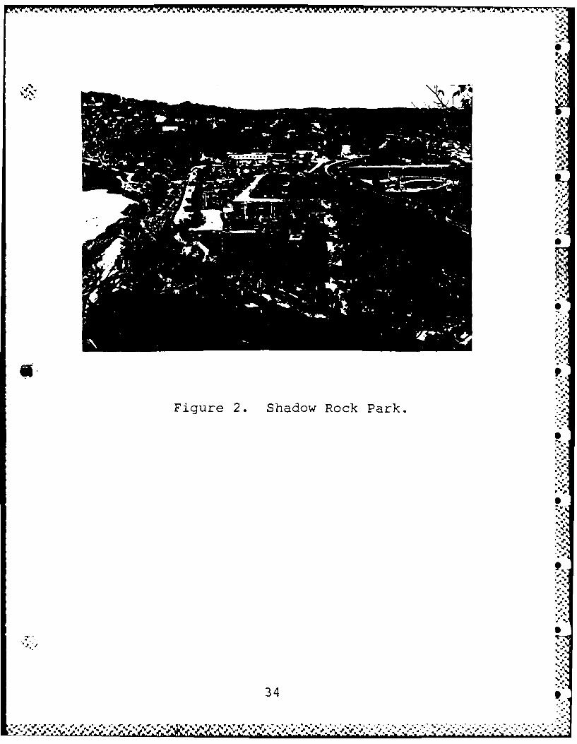
S
V.
~. .~.A
V..
p..p.''V.
/
S
S
p...p..(V **3V.
'V.p.
*a.
S* V..-Figure 2. Shadow Rock Park.
S-a
* 'WV.a.
V...-V.-
'V..
SV.,.
a,..
.5'
'5'
9'-a-.4--aV...'-
S
5,
34 I
. S ~ .f.(..Waf tV. ~ - ,.~,,' *'%* ~* . .;*. . .- - V.,.- .~ a. -* .** .....
% ' % V. . ~ 4- '.~ 's *,w.:'
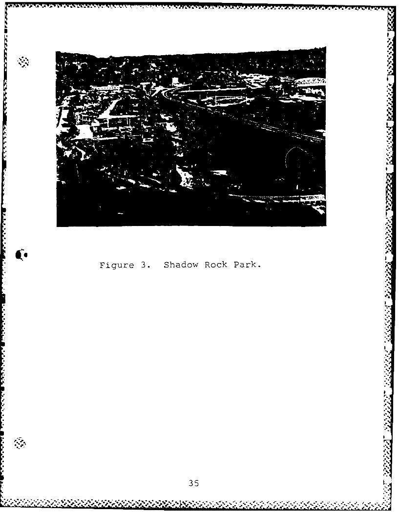
.M t k -I -
,Rl1
t, 4.
12,.'
S 'V
Figure 3. Shadow Rock Park.
; -5
3s1

4-
4.4.4-
I.
'4. %4
p
.4
.4..
-4
F'.4
-p.
4.4
'4.4*~.
.4
'4.
U) -44.
-~.'- 0 .4A %t51U?~ - .4..;u -: '.4
>-.tf) 'p.
~ (N 4-
I.4 44
4-
.4.4.
-4-~ 4-
.4-4-~E -WOH V4~LZ
4WV
.4
44%
4 44%
-~4 4-40
-4
p..
4.
W
.4-4
.44.
* 'V.4'
36 I4."'
I-'-4
.44,4 4~444 44 44-~~4~4*4.4. '~44 '~I4 *~b*,.4
*4
.4 . ~ 4
.*j.*~,.' .d.' ~ -~ -~-- ~ -4,..' -~ - 4~~444 ~4*4.4~ - *44* *p.*"Y' "''-4' -4~.....-' ~4. ~ ** 4 ~ .4.44.4 **44~ 4444 .44*-4 . ' 4 ' -V. ~ *'4~'.U4

,'.
.:.:,
.4 . .
€..,.
- 'A . , , , : t ,..*• ' . - . '',- .
-, " - / " * - ". "-.', ", '-- "•" -"v •/',, . - ' -" t ,,4....; -- .- ..' , • "a - a. _ . r l ,; ,
. " t '-p
- ,, :i ... ,L4. S.. . - .-
,,'.- , _
, . .- ) , ....
4,:
Figure 5. Civil War Cartoarapher's Map .'
W~1*
. 9" ,a 4 -,-
*47* '-4

-z I-
Z C-
zLi I LIIMIILIIiLLL liJLIH w
II I~ 3S) L3
EJw
VII
V-
2~- ai 3A-1 2 7nl

z
-I
03MI.
_ _ _ _ _ w I.
-u D

. %
z= I-
C', .',
00
LL-H-
I~~
Ii-.F-
~wHal
IK0
-4.
c',.-i
40

p
C UE. ~ O
.5~; ~ Sa3 V C)~ OO0
-) LJ yI
0I
0 1 V 5 ,
Ou 'm0 3:b C) x 0 CL-
c.5
oi Z-.Z
00
ISI
__ 0
414
5*U-4

%F f Wt lq-j 7d
.5.~~ -Z'___
zO I-T
j 1±
S '.
U %

FIELD INVESTICGATICNS
Field investigations were carried out at Old Forsyth from 13 - 17 October1986. W. J. Bennett, Jr. directed the field work, assisted by Jack Ray,John Northcutt, and Jeffrey Blakely. Other crew members included MaryBennett, John Northrip, Robert Abbott, and Brauna Hartzell. James Hoelscherserved as consulting soil scientist.
The goal of these investigations was to document the nature of the culturaldeposits at the site and to gather a sample of artifacts. Morespecifically, the effort concentrated on identifying possible culturaldeposits which could be securely placed in the mid-19th Century.
aa GeneraI Strategy
, As indicated above, prior to field work extensive documentary andcartographic research had resulted in a series of overlay maps onto which wehad plotted the best estimates possible for the locations of the variousstructures and impacts known to be at the site. Prior to the placement ofexcavation units other than the perimeter profiles an attempt was made toplot, on the ground, the major streets and intersections north and west of
a. the courthouse square. This was done using a tape and transit with thenortheast corner of the intersection of Lincoln and Jackson streets as thepoint of reference. Street corners were marked with stakes or, in the casesof paved areas, small painted spots. The resultant "plat" matched very wellwith the remnants of Jefferson Street which are still visible in the park.
With this information as a basis, a general strategy was developed by whichno excavation would be undertaken in those portions of the site known tohave been heavily disturbed such as areas designated as borrow pits andintensely developed portions of the park. Various options were discussed atthe site with the former Mayor of Forsyth, Jerry Gideon, whose knowledge ofthe location of various places in the town prior to its removal was aninvaluable asset to the project. The subsequent field investigations weredesigned to concentrate on areas of the site where previous excavation hadindicated sane likelihood of positive results and in areas not previouslyinvestigated for which known impacts were thought to be not as severe.
Using these guidelines excavation was undertaken in five different areas of
the site;
(1) Along the edges of the site at the edge of the landform;
(2) In the southeastern portion of the site, east of Highway 76, whereprevious excavations had recovered mid-19th century artifacts;
43
-J. .;J ~ ~ ~ .' .*~a ~ V r ./ . % . ~t / = \ a

(3) Within the courthouse square along the foundation lines of the 1890courthouse which was thought also to be the foundation line of the 1855courthouse and within the confines of a Civil War Period structure;
(4) A large area of the park west of the courthouse square which had beenthe site of both business and residential structures; and,
(5) At the western end of the site near the Ice House where the Historic"-. Period Indian burial had been reported.
" Excavations were not conducted in the area of the site south and west ofHighway 76 where extensive modification had taken place. Nor was excavationattempted in the northwestern portion of the site beyond the limits of the1890 Plat Map. This area seems to have always been used for cultivation orpasture and no structures were built in this area according to all theavailable cartographic, photographic, and oral historical information. Forthis reason significant cultural deposits were thought unlikely to bepresent.
Figure 11 is a plan of the site showing the placenent of archeologicalexcavation units in reference to the 1890 Plat Map and the location of theknown Civil War Period structures.
Finally, it should be noted that while field investigations were limitedalmost exclusively to the site of Old Forsyth itself approximately 4 hourswere spent in a surface walk-over and bank-line examination of the fieldnorth of Swan Creek. This area outside of the site boundaries, fran whichnumerous prehistoric cultural materials have been recovered, has beensubjected to numerous impacts related to its cultivation. Moreover, thisarea has been subjected to frequent flooding with the result that evenfairly recent cultural materials are likely to be buried beneath alluvialdeposits ranging from a few centimeters to more than a meter.
Site Stratigraphy (Figures 12, 13, 14)
One of the main goals was to document the natural stratigraphy of the site.We attempted to meet this goal by the excavation of 5 units along the edgeof the site where it was hoped that the occupational and constructionalimpacts had been minimal. Figure 11 illustrates the location of Profiles 1- 4. Profile 5 was excavated on the White River side to the east of thecamp ground and does not appear in our site plan.
Two of the 5 units, Profiles 1 and 4, were judged to have been dug intoareas where a natural stratigraphic sequence was still in place. Profiles2, 3, and 5 were judged to have been artificially truncated or disturbed.
V .Profile 1 (Figures 12 and 13) contained a thick silt loam A horizon withinwhich 2 divisions could be identified. This horizon overlay a
44
U,.. .. ,.j...,,..J "..'--'...J.. ....-
.- ', ''' -' ' -' '-''' ' r .. r, .. , "._, ' . .

Li.
0 a
U--
~i LL. lLrJ
w! cLa) --
> _ _ _ _L
__ _ __o__ _ c
m Li
H-v

,%. .-- ~K"r.
' m-
fa.t
.-.1 %
,rcf11e°
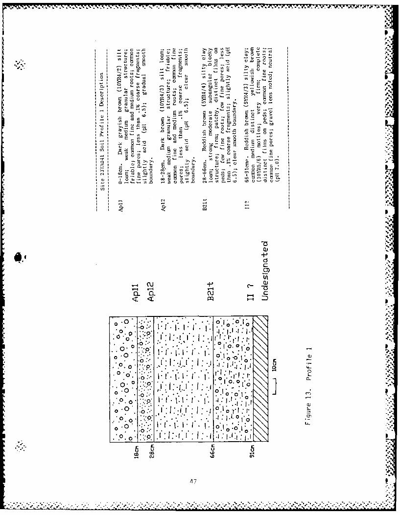
C: r- A
20 C. a CUto no-
10 0CJ0
cu: .... W I
z~- 0 fl) C6
-C 0. a.0
I o rE 'n E 0C.
I or,
I m
I - P
0)7iAp
d)
0 .0 ~~ ~~ ~ :,.
. .. I. o'.
0'~.~
1.1.10.1
0. 0 .V .1
0 ' o ~ 1 :'.C ::i : .0 C
0'
uIm C13 %

'n.
.- 00>- co a- r-3 ' -- 1.o-
-~ C)- - ,
bca 0>~ C). 0.- r-to=J 0)u b D r- V I
Z: u
(D. COL0 'o U. v -
101 2E0~O) ~ Q LO ~ ~ 0l~fl 1- ~cJ~ ~ .b.-a
0, CL.- E
-a~
0 C3 .2 0 ca
a co t
C-) V- Iez c
01 I-0
L )C
0 0 Z)oE~~~~~~~ > nt .n cDE
C4C
- d- .2 .A
LU CL
S-S
4R..

well-developed silty clay loam B horizon which extended to a depth of 66cm.Below 66cm to a depth of nearly 1 m was a horizon of reddish brown siltyclay which seems to be best interpreted as a different depositional sedimentalthough it is possible that it represents simply a lower sub-unit of the Bhorizon (B23).
Profile 4 (Figure 14) was dug to a depth of 1.26 m. Here the A horizon wascomposed of a very fine sandy loam extending to a depth of 49 cm. The Bhorizon was well developed in its lower member, a sandy clay loam B22t,which ended at approximately 1.1 m. The lowest unit observed, a silty clayIIB23t, was definitely from another, earlier alluvial deposition. There wasno buried A horizon observed at this contact, however.
These stratigraphic probes gave us sone insight into the naturalstratigraphy of the site. It seems clear that approximately the upper 1 mof the site consisted of a single soil developed within an extensivealluvial deposit. The development of the B horizon in this soil indicatedthat the deposit within which it had developed had been in place at leastseveral thousand years. The unit upon which this sediment had beendeposited was thought to be considerably older but no estimate of the age ofeither deposit was formulated. However, prehistoric cultural materialswithin the upper unit suggested that humans were present on the landform,perhaps as it was developing, and we cannot rule out entirely the4. possibility of human use of the upper portion of the lower unit although noclear evidence of a buried A horizon was observed at the contact betweenthese 2 depositional units.
The difference in the texture of the A horizons of the 2 profiles, sandieron the White River side, was to be expected given the site's setting wherethe coarser White River sediments settled in periods of overbank flooding.
These profiles were successful in allowing us to identify the B horizon of
the upper unit as a silty clay loam or very fine sandy clay loam of reddishbrown (5YR4/4) to dark yellowish brown (10YR5/4) when they were penetrated -in excavation units elsewhere on the site.
49 ,
.- ,,", .S.*. -'. , '. A. , , , -Cp '. . . . * ." ." - ..A ." '

- k
01
Southeastern Portion of the Site (Figure 15)
Even though the southeastern portion of the site had been heavily impactedby the construction and use of the park, previous test excavations hadrecovered mid-19th Century artifacts and evidence for possible mid-19thCentury features in this area (Turner and Purrington 1980; Benn 1984).
Excavations in 1980 had been conducted west of Benton Street in an area nowoccupied by a power line. This consisted of the excavation of 7 test unitsmeasuring 1 x Im to varying depths. Units 1 and 3 were placed some 30msouth of units 2, 4, 5, 6, and 7 (Turner and Purrington 1980: 58). TestUnit 1 was dug to a depth of 46cm. The upper 15cm or so of this unitconsisted of a disturbed soil and thin gravel layer. Below this was arather homogeneous soil layer characterized as a dark brown alluvium withspecks of charcoal. In unit 3 an undisturbed B horizon seems to have beenreached at approximately 50cm deep. Above this was a series of mixeddeposits including a gravel lens or layer from about 15 - 25cm below thesurface.
Test Unit 2 produced a thick layer of charcoal from 30 - 50cm below surfacebetween two debris filled layers containing significant amounts of 19thcentury trash. It seens as if Unit 2 reached an undisturbed B horizon atabout 70 - 75cm which covered a layer of densely packed pebbles and cobbleswhich, augering indicated rested upon a layer of silty clay to a depth of atleast 160cm. Investigators suggested that the charcoal layer mightrepresent destruction of a structure during the Civil War disturbances atthe site.
Other possible evidence of such a disturbance was found in Test Unit 4 wherea pile of rubble, possibly a part of a foundation or wall was encountered atapproximately 70cm below the surface. This appeared to be resting uponundisturbed soil although one intrusive elenent was noticed.
Test Unit 3 encountered a gravel layer at the 15cm level and appeared to bedown into a undisturbed B horizon at 50cm deep. Test units 6 and 7 wereplaced in areas where a sidewalk had to be ranoved. These units do not seemto have reached undisturbed deposits at 60cm deep.
In 1984 another set of test excavations was conducted in this area of thesite by the Center for Archaeological Research. This consisted of a seriesof shovel tests and the excavation of 1 test unit (1 x im); Test Unit 10.During the excavations of the shovel tests "Foundation stones and concrete ,pieces were revealed at 30-40cm depth in shovel-tests 2, 3, 4, 5, and 7.Since the stones appeared to form an alignm-ent of a possible building, TestUnit #10 was excavated between Shovel Tests 4 and 5 to expose thefoundation. When cleared, an east-west trending foundation line wasrevealed along the course of the proposed buried cable and in line with abuilding wall shown on the Civil War town map. The foundation consisted ofan irregular line of chert nodules and limestone pieces set in coarse
50 "
':, ,J . 'g'..'"J c .:r"% .. " , ... ,-''z " 2 .. .,2 " * * -C. * .'. '',~ 2 ..
".. " ".''-:. ' .:." , ;"."-"-' . 2,.-
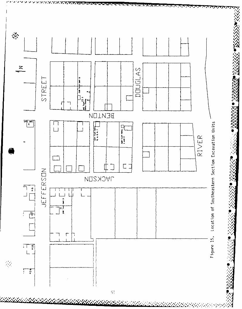
h~Li
Li I - D
> >
CLiLr--
NI~ 0r
0 I
D~:: L

S-
concrete over cherty gravel. Other isolated chert rocks were found on thestructure floor near the foundation line. A burned log or board beam restedon the foundation and perpendicular (north-south) to it. The test unit hadbeen positioned along the inside wall of the foundation so that the interiorfloor of the building was exposed. This floor appeared to have been burnedreddish in color. Overlying the floor was 6 - 10cm of dark gray brown fillcontaining large amounts of window glass and other historic debris. ...Beneath the historic floor the soil was devoid of cultural materials, exceptfor an occasional prehistoric chert flake" (Benn 1984: 41,42).
The layers observed in the profile of Test Unit 10 are described as follows(Benn 1984: 42):
0-30cm Alanthr dark brown (10YR3/1), silty loam gravel,unstructured and disturbed, carbon flecksand historic debris, abrupt boundary
30-37cm foundation, footings, structure fill
37-44cm A2anthr dark brown (10YR3/2), silt loam,unstructured and disturbed, historicdebris throughout, abrupt boundary
0 +44cm B2 yellowish red (7.5YR5/4), silt loam, weakmedium subangular blocky, manganesemottles.
Three test units were placed in this portion of the site during the 1986field work; Test Units 1 South, 2 South, and 3 South (Figure 16). An S
attempt was made to locate these units as close as possible to Test Unit 10of the 1984 excavations, although we could not be entirely certain of itsexact location.
Test Unit 1 South was a 1m x 2m unit placed at the end of the highwayembankment. The top 45cm or so of the unit was judged to consist of highway S
fill and was shoveled through without screening. This consisted of a 6cmdeep dark loamy root zone and fill material, a yellowish brown clay withnumerous light brownish gray mottles and iron-manganese concretions whichwas obviously out of place. Below this from 45 - 65cm was a very darkanthrosoil rich in Euro-American artifacts and it was thought that a depositsimilar to that reported in the area in 1984 had been reached. However, the P
extremely sharp boundary between this layer and the underlying B horizonmade it clear that this layer was displaced. There was no organic stainingfrom the anthrosoil into the B horizon and there were no Euro-Americanartifacts recovered below 65cm. We concluded that this anthrosoil or largeportions of it had been deposited there during recent earth disturbingactivities.
.
52
,,,- .. '. ,-. .'.,.-*V '" ''' , ,'. ," ,',,, . " ,.;'',",'" -".--._. . .... ,-. . " .- ,' .. '.. •" '. •."..,,',-*d**** '-".-

~'-41
'..
Ap
Test Unit 1 South ',
East 'oatt
5.m
6~c, very dark grayish brown OYR3/ st loalay-
yellowish brown IOYR5/6) siti clay
ws ni r Sowth Test bnit gr3y SIYR6/ nolleand nu'er ou-s iron-vnnnganese concr-etions.
dark reddgh brown v5YRy/2r sasy clay -brdisplaced rhidden ,
• ~ ~ dr brown yeCYo3$h drown 1YR1)1-yctyelws brown.
s lit lon'-Y4/)moteTest Unrt 2 South Test Unit 3 SouihSouth \V.o,[ North \da.Lt 4.,
very dark grayish brown very dark grayiSh brown L ,,
llOR3c)$a clOn¢1YR3/2) s~lmy lOaM~ 10cmt-.
d~kbon R/)dark yellowish brown •
$C (OY 4/6) nao 'led ____ I2 cn stones Tnslty clay
2c ye(lowisM brown (IOYR5/4) Unexcavateddark brown OYR3/3) mnottled ca w/FeMn
'a'
Figure 16. Test Units 1 South, 2 South, 3 South: Profiles
53 - a. a.4. .4 4--. -,
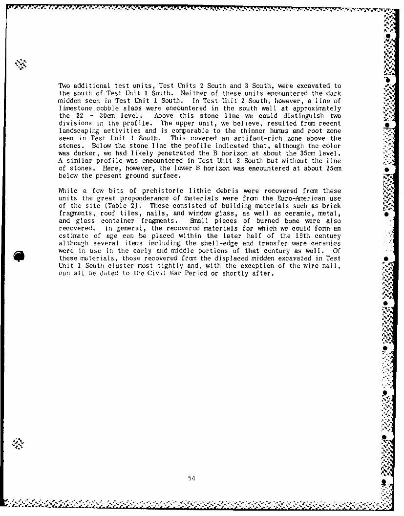
P .1
NS
Two additional test units, Test Units 2 South and 3 South, were excavated tothe south of Test Unit 1 South. Neither of these units encountered the darkmidden seen in Test Unit 1 South. In Test Unit 2 South, however, a line oflimestone cobble slabs were encountered in the south wall at approximatelythe 22 - 30cm level. Above this stone line we could distinguish twodivisions in the profile. The upper unit, we believe, resulted from recentlandscaping activities and is comparable to the thinner humus and root zoneseen in Test Unit 1 South. This covered an artifact-rich zone above thestones. Below the stone line the profile indicated that, although the colorwas darker, we had likely penetrated the B horizon at about the 35cm level.A similar profile was encountered in Test Unit 3 South but without the lineof stones. Here, however, the lower B horizon was encountered at about 25cmbelow the present ground surface.
While a few bits of prehistoric lithic debris were recovered fran theseunits the great preponderance of materials were from the Euro-American useof the site (Table 2). These consisted of building materials such as brickfragments, roof tiles, nails, and window glass, as well as ceramic, metal,and glass container fragments. Small pieces of burned bone were alsorecovered. In general, the recovered materials for which we could form anestimate of age can be placed within the later half of the 19th centuryalthough several items including the shell-edge and transfer ware ceramicswere in use in the early and middle portions of that century as well. Ofthese materials, those recovered from the displaced midden excavated in TestUnit 1 South cluster most tightly and, with the exception of the wire nail,can all be dated to the Civil War Period or shortly after.
V
54
I.,""-
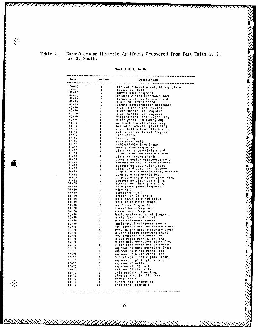
%o
0d.
Table 2. Euro-Anerican Historic Artifacts Recovered frcrn Test Units 1, 2,and 3, South.
Test Unit 1, South
------------------------------------------------------------------------Level Nurnber Description
---- ----------------------------------------------------------------------------00-40 1 stoneware base? shard, Albany glaze00-40 square-cut nail00-40 mammal bone fragment40-50 Bristol glazed stoneware sherd40-50 6 burned plain whiteware shards40-50 1 plain whlteware aherd40-50 1 burned semlporcelain whlteware40-50 1 clear plate glass fragment40-50 1 clear bottle/Jar fragment40-50 1 clear bottle/jar fragment40-50 1 purpled clear bottle/jar frog40-50 1 clear glass rim sherd, cup?40-50 1 aquamarine plate glass frog40-50 1 burned aquamarine glass frag40-50 1 clear bottle frog, lip & neck40-50 1 unid clear container fragment40-50 1 Iron staple P.40-50 1 Iron spring &40-50 6 square-cut nails 11j40-50 4 unidentlable Iron fraga40-50 3 mammal bone fragments50-60 1 plain white porcelain aherd50-60 2 burned plain whiteware sherds50-60 6 plain whiteware shards50-60 1 brown transfer ware,monochrome50-60 1 aquamarine bottle base,embosad50-60 2 aquamarine bottle/Jar frogs50-60 1 clear unid container fragment F-50-60 1 purpled clear bottle frag, embossed ,.50-60 1 purpled clear bottle base ,%50-60 1 purpled clear pressed glass frog50-60 I aquamarine plate glass frag50-60 1 aquamarine plate glass frog50-60 1 unid clear glass fragment aJ50-60 1 wire nail50-60 1 square-cut nail50-60 3 square-cut (t) nails50-60 6 unid badly oxidized nails50-60 3 unid sheet metal frogs50-60 9 unid bone fragments50-60 2 burned bone fragments50-60 2 mammal bone fragments50-60 1 badly weathered brick fragment50-60 1 slate frog (roof tile)60-70 8 plain whiteware sherds60-70 2 shell-edged whiteware shards60-70 1 sponge-decorated whiteware sherd60-70 2 gray salt-glazed stoneware sherd60-70 1 Albany-glazed stoneware sherd60-70 1 red transfer whiteware shard80-70 1 olive-green bottle/Jar frog60-70 1 clear unid container glass frog60-70 2 clear unid container fragments60-70 4 aquamarine unid container frags60-70 1 aquamarine plate glass frag60-70 1 aquamarine plate glass frog -
60-70 1 burned aqua. plate glass frog60-70 1 aquamarine plate glass frag60-70 2 square-cut nails60-70 1 square-cut (?) nail60-70 2 unidentifiable nails60-70 1 unid oxidized Iron frog60-70 9 zinc canning jar lid frog60-70 1 mammal tooth60-70 5 burned bone fragments60-70 10 unid bone fragments
55
%

Table 2. Euro-American Historic Artifacts Recovered from Test Units 1, 2,and 3, South. (continued)
Test Unit 2, South
Level Numriber Description----------- ----------------------------------------------------------------------------
I,-1 is1 plain whiteware sherd00-15 1 pearlware? ahd w/molded design00-15 1 aquamarine unid container frag00-15 1 clear glass bottle frog00-15 1 aquamarine window pane frog
00-15 1 purpled clear bottle lip frag00-15 1 unld clear glass fragment00-15 2 wire nails
00-15 3 square-cut nails00-15 2 unldentlflabIefnails.00-15 1 steel can (T) fragment
00-15 4 brick fragments15-25 2 burned unid stoneware rim sherds15-25 I burned earthenware sherd, red paste
15-25 1 earthenware sherd, yellow paste15-25 1 sponge-decorated? sherd,blue design15-25 1 clear bottle/jar base frag15-25 1 unid aquamarine glass frag15-25 1 bottle neck & lip, mold blown15-25 4 wire nails w/aluminum washer15-25 2 square-cut nails15-25 1 wire nail15-25 1 wire (?) nail15-25 1 wire nail15-25 2 wire (M) nails
% 15-25 9 unidentiflable nails% 15-25 15 unid oxidized iron frags
15-25 1 concrete (?) fragment15-25 3 burned bone fragments15-25 2 brick fragments15-25 2 brick fragments25-35 2 burned plain whiteware shards
25-35 3 plain whiteware sherdsIO 25-35 1 sponge-decorated rim sherd, blue25-35 1 unid glazed earthenware frag25-35 2 aquamarine window glass frags
. 25-35 1 aquamarine plate glass frag* 25-35 1 wire nail
25-35 1 wire (?) nail25-35 1 square-cut nail25-35 1 square-cut (?) nail25-35 3 unidentifiable nails25-35 2 mammal bone fragments25-35 2 badly weathered brick frag35-45 2 plain whiteware sherds35-45 1 burned glazed earthenware frog35-45 1 green transfer wave rim sherd35-45 1 unid aquamarine container frag35-45 1 burned aqua. windoW glass frag35-45 1 unid clear glass frag35-45 1 aquamarine window glass frag35-45 2 aquamarine window glass frags35-45 1 brick fragment
*" Test Unit 3, South
Level Nurber Description
00-15 1 shell-edged whiteware,blue edge00-15 2 plain whiteware sherds00-15 1 sponge-decorated whlteware,red00-15 1 purpled clear bottle/jar frog
* 00-15 1 unid clear container fragment* 00-15 1 aquamarine window pane frag
00- 1 5 light blue unld container frogN -D.0-15 Iaquamarine unid container frag
00-15 1 clear glass window pane frag00-15 2 square-cut nail00-15 3 unidnetifiable nails
- 15-25 1 unidentifiable naIl15-25 1 luminum washer15-25 a unid oxidized iron trags15-25 2 bone fragments15-25 5 badly weathered brick frog
---

Excavations in the Courthouse Seuare (Figures 17, 18)
Documentary, cartographic, and oral historical investigations had given us a Vconsiderable amount of information about the courthouse square. We knewthat it had been the site of the Civil War Period courthouse (built in 1855and finally destroyed in 1885) and the Civil War Cartographer's map alsoindicated that other structures were in existence on the square at thattime. It was also reported that after the torn-down shell of the 1855courthouse had been removed that the 1890 courthouse was built in the samespot. The other buildings, which we presumne were destroyed during theFederal occupation, do not seem to have been reconstructed. Thus about 1900the courthouse was likely to have been the only structure on the square. In1911 an extension of the courthouse was added to the existing structurewhich made the north end of the courthouse flush with the street. Later on%public rest roans were added to the southeast corner of the square. Earlyin the 20th Century the square contained numerous large trees which weresubsequently removed. Sidewalks were also added to the square in the 20thcentury (Figure 19).
A sing-le 1 x lm test unit, Test Unit #8, had previously been excavated inthe courthouse square area during the 1984 Center for ArchaeologicalResearch investigations (Figure 18). The unit was placed in an area where aCivil War Period building was plotted. This unit encountered "four layers
4Q of historic sediments and disturbances overlying lower B horizon subsoil"(Benn 1984: 40). It was judged that the uppermost layer, a dark brown siltloam with gravel layer, was of relatively recent origin. The second layer -consisted primarily of gravel and it was suggested that this had been placed ipas a base for street or sidewalk construction. The lower 2 anthrosoils werethought to represent earlier historic period disturbances and earth moving.No materials earlier than the late 19th century were recovered frcrn thisarea.
'Me 1986 excavations divided the courthouse square into large 5 x 5m blocksusing the existing streets and curbing as the northern, western, and
southern boundaries. The eastern boundary was estimated by taping off theplatted area of the square fr m the western side. These blocks werenudered consecutively from the northwest corner. The 25 units within theblocks were also numbered consecutively from the northwest corner of each
block. In choosing locations for the test units, it was necessary to --consider that many areas had been impacted by a variety of 20th centuryadditions to the area. This included the installation of a public rest roomwith sidewalks, the sidewalks in front of and leading up to the courthouse(Fige Fut wa lirther, a series of monuments had been erected on the sitesince the renoval of the courthouse. These consisted of a number of stonemarkers, a large, circular water fountain and shrub display, a comnemorative
metal marker, flag pole, and a line of small trees (Figure 20). w e
In all, 8 units of excavation were placed in the courthouse square; Block ,Unit i0 (B1, U10); Block 4, Unit 22; Block 6, Unit 25; Block 7, Unit 21;
*. - Block 26, Units 4, 5, and 9; and, Block 27, Unit 21.
57
S.-
{ ; . loam.with grav layer, .as of reltively reent origi.- The second... layer.-...- ... -
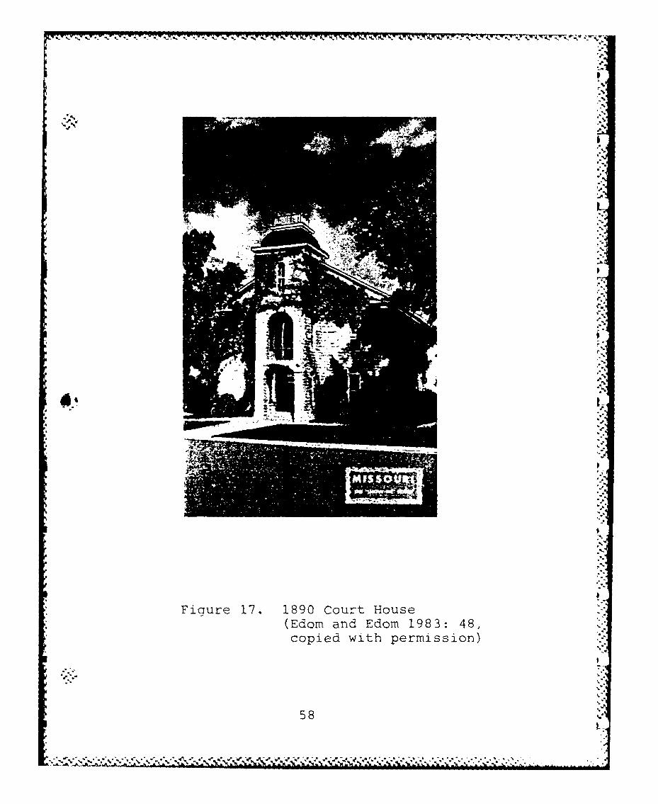
.Poem
Fic~re 1. 190 Curt ous
(Edo andEdom1983 48
copid wih prmision
58.

*~~~~~71-7 - -7.A . .. ~ -- ~.
LrL
m
cur
&ucu_ QJ

-----------------
'-iiI~.
V
N..s*( *\.*
I
8 214U0 21 5a1 ~i~O7- LI '-p..
0
*o
0
0
'-4 S
0
*0 9.'Cu 0
Cu 0
D 44*0*0
SL
'a.-
x C(4
(U.0.4 0
at 0
44(1~ 0
C0
11 0
/ -4
9.
-'I-. U-
'a
'a.
________________________________________________________________________ i.'a
a.'.. ~ .~a4'
a . a - ~. ~ a'. * ~ -. .. p .. ~ a'a... -.N'-*.*.'.*.*.%- 'a'~..x.................~ ~-a . a a - . a . .' -'a.'
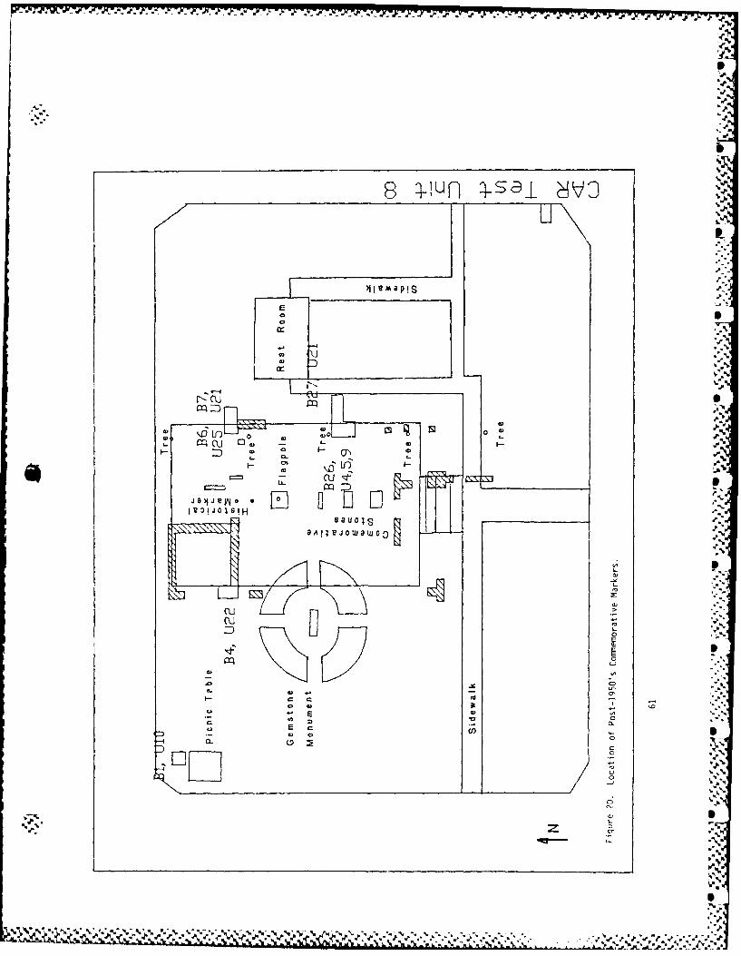
V. 'Y VV
e q-!n 4-s i dv
cr1
"D U-)
0 -
r=p
0 A 100
_ cuc-
4D-
.0)
EEw 0)
CuCD% % z

An attempt was made to determine if there was any relatively undisturbedarea within or near the square which could be investigated for evidence ofthe Federal stockade. As all the area outside the square had been rebuiltand the streets paved this only left the square itself as a possibility forCivil War Period remains such as the stockade. Given this situation, it wasdecided to explore the northwest corner of the square, Block 1, Unit 10(Figure 21), in order to determine if there were any remains in the area ofa second Civil War Period Structure. Excavation here revealed an Ap horizonextending to a depth of 18cm with considerable amounts of gravel. Thiscovered a transition AB horizon to a depth of 36cm which overlay a very welldeveloped B horizon with large amounts of iron-manganese concretions. Thepresence of the iron-manganese concretions in such large numbers stronglysuggested that the top of this profile had been artificially truncated. Noindication of the Civil War Period structure or its use was recovered. Itseems clear that this portion of the square had been rather drasticallyaltered.
Else here on the courthouse square excavation efforts were directed towardinvestigating the possibility of extant Civil War Period deposits related tothe courthouse construction or early use. To this end, several 1 x Im unitswere placed in areas where presumed foundation stones were observed on thesurface. Since tradition had it that the 1890 courthouse had been built onthe same spot at the 1855 courthouse we hoped that some evidence of thisearlier structure could be found.
Excavation in Block 4, Unit 22 was undertaken at the spot at the northwestedge of the original end of the 1890 courthouse. The 1911 courthouseextension had gone beyond this line and so it was hoped that evidence of thecorner of the 1890 and perhaps 1855 courthouse could be found. However,excavation indicated that this portion of the area had also been greatlymodified. As shown in the photograph (Figure 22) the foundation for theextension wall was placed on a thick bed of stones and cement. It is ourjudgment that all of this area was cleared to subsoil for the installationof this base.
Excavations at the original northeast corner of the courthouse met a morecomplex situation. A unit, Block 7, Unit 21, was excavated outside of thepresumed east foundation wall. The west profile of this unit revealed thepresence of the base of a flue box which had been added along with the 1911addition still remaining in the foundation. This feature was furtherexposed in Block 6, Unit 25 (Figure 23). Just east of the wall edge weencountered a ditch (Figure 24) into which a north-south pipe had beenplaced (Figure 25). We believe that this is the water-line for the restroomstructure constructed on the southeast corner of the square in the early20th century.
Excavation in Blocks 26 and 27, however, may have recovered the foundationof the 1855 building. Here we found a much wider foundation of dressed
'. ~limestone and a considerable amount of brick and stone rubble (Figures 26,
62
J#

- ~ ~ ~ ~ ~ ~ ~ ~ ~ ~ ~ ( a) A PF ~ - - - -~.. - - - - - - -
I q 0 0 -0
0 ~ "0 Q -
0 0 - f Ir
E. ' 0-
'U..- 2
102 I
II C6cI.
coJ
-I
x-
0 1.
.010
S0M 0t, .1 0I. I to

1 4p.
"S..
- ]j r Dinao;n of 191 :<te'rtjof to the CutHu~2c lU~I

* - - ... ~ .A - A - -- - - . . - - ~ . & ~ * * * N
%~j.
4.
4..,.-J
N
4...
4-..
.4...4.
'4.
"I..4.
4.-
-p
I.
p
.
N.
4.
N
S
FiQure ~' Flue Fox footing: ~1ock 6. 'Jriit. FF
p
I
I.
r~ -~ I

4~~~~ %.A .
%,
* -. VW- .
i -.- t .m C m x w te ( c."
il0

oot.
Figure 26. Top of Double Foundation: Block 26, Unit 5
Zx-
Figure 27. Rubble inside the Double Foundation: Block 263, Unit 9
67I

27). Bas ical ly 5 di f ferent soil1 uni ts were observed in the soil1 prof iles.:outside of the wall structure (Figures 28, 29); the lowest being the sterile
. B horizon marked by the numerous iron-rmnganese concretions. The upper 4• ". units consisted of a thin, 4/5cm thick, root or hums zone which lay~directly upon a silt loam mixed with numerous gravels. These upper units we
believe represent landscaping efforts af ter the destruction of thecourthouse and the development of the park. Both of these lower unitscontained large amounts of building rubble with lots of brick. The upper
layer can be seen inside the wall as coequal with a trench which we believeto be the foundation trench for the 1890 courthouse wall which is ourinterpretation of the profile inside of the wall (Figure 30). If this isthe case then the lower unit would relate to the mid-19th century structure.
While, as expected, numerous Euro-American artifacts, particularly building,
materials such as brick, glass, and nails, were recovered from the :excavation in the courthouse square (Table 3). However, no materials whichcould be dated securely to the mid-19th Century were recovered from this
area.
*-,
In sunmry, the 1986 excavations on the courthouse square revealed aconsiderable amount of construction disturbance which was to be expected,given our knowledge of the site. However, the soil profiles along the ?eastern courthouse foundation seemed to accord well with that documented"
. 4 during the 1984 work. COwbined, this evidence indicates that it is possible
" to delineate several different deposits dating to the 19th and 20th century~~use of the site within the square.".
6
p
p
F"
" 68 F
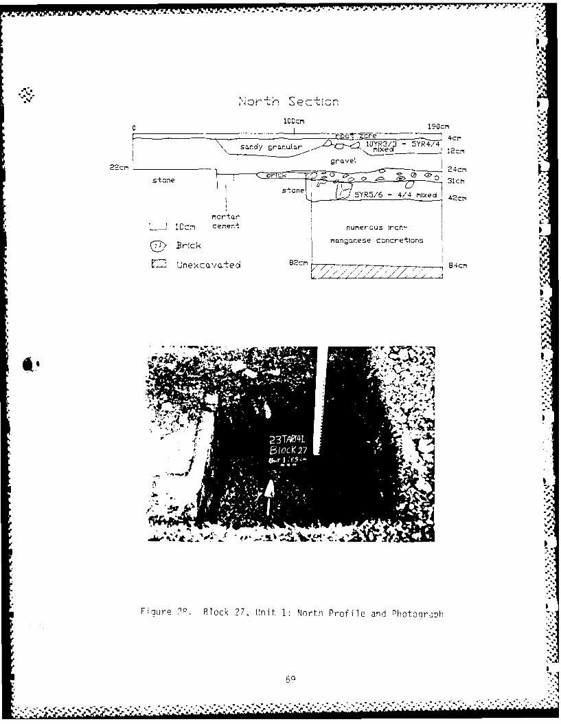
Nlr- Section-
1C'CM
4cm-
,DZj- 10Yne 5YR4/4\ sandy granutar m rxeCI
22cm rae 2c
-on 5YR5/6 -4/4 Nd 42cm
L I C~rn cem~ent numerous Iron-
Brick< mnga~nese concretions
~Z Unexcava tecd 82cm, , ~ 84cm
-e.
+ 44.
X.t
5I
23T~e4-.
Figure ?P. Block ?7, Ujnit 1: North Profile and Photoojraph
69

-4.
%4
0 15 C
5 cm 5 ne-m 'b
conl- 22c
.store
N ~5YR5/6 -4/4 mitxed oe
numerous Iron-rianganese concretions L Urexcavate-J
82CMBrc
/ 7Ile,
~ /7 -
011
Figue 2. 1ock?7, n it I Souh Pofil an PhtoqarN
7*4r)
% %

ICYR3/ ',ca
.t7.
I..
711
069

Ia - 7 .-- IN T q 7.1 Z S
Table 3. Euro-Anerican Historic Artifacts Recovered fran Courthouse Square.
Block 1, Unit 10 ft.........-------------------------------------------------------------------Level Nusber Description
---------------------------------------------------------------------------------00-15 11 burned plain whiteware @herds %00-15 4 plain whiteware sherds, I rim00-15 2 burned plain whiteware rim sherd00-15 1 plain yellowware rim sherd00-15 1 blue transferware,monochrome00-15 I purpled clear container frag00-15 1 bright green bottle/Jar frag I.
00-15 1 cobalt blue container fragment00-15 3 brown bottle/jar fragments0-i 1 burned brown container frag "d,00-15 6 brown container fragments00-15 1 brown container frag, stipled00-15 L brown bottle/jar base fragment00-15 3 clear mo'd-blown bottle/jar frags00-15 4 clear bottle lip fragments00-15 1 bottle lip fragment00-15 3 clear embossed bottle/Jar fraga00-15 1 clear container fragment 'a00-15 19 clear container fragments00-15 18 unid clear glass fragments00-15 1 unid aquamarine glass fragment00-15 3 aquamarine container fragments00-15 18 clear window pane fragments00-1S 1 unid plate glass fragment00-15 2 aquamarine window pane fraga00-15 8 crown-type bottle caps00-15 1 sardine can key %00-15 2 oxidized steel buttons00-15 6 unid oxidized Iron frags00-15 1 oxidized wire fragment00-15 1 aluminum wire fragment00-15 3 unidentifiable nails I?)00-15 13 square-cut nails00-15 1 brick fragment00-15 5 brick fragments00-15 I concrete fragment00-15 7 unid plastic fragments14-25 1 burned plain whiteware sherd14-25 2 clear window pane fragments14-25 1 unid aquamsrine glass fragment14-25 1 wood charcoal14-25 1 brick fragment15-25 9 plain whiteware sherds, 2 rim15-25 2 clear bottle/jar fragments15-25 1 burned clear container frag15-25 4 clear container fragments15-25 1 clear embossed bottle/jar frag15-25 6 aquamarine window pane frags15-25 4 clear window pane fragments15-25 3 square-cut nails15-25 2 unidentifiable nails (?)15-25 1 crown-type bottle cap15-2S I heavy bolt15-25 4 unid oxidized sheet metal15-25 6 brick fragments25-40 1 plain whiteware sherd
7?
IL

%%
Table 3. Euro-American Historic Artifacts Recovered from Courthouse Square.(continued)
Block 4, Unit 22
Level Nunber Description
00-15 1 plain whiteware aherd00-15 7 aquamarine window pane frags00-15 10 clear window pane fragments
00-15 1 clear container fragment00-15 3 square-cut nails .000-15 1 crown-type bottle cap00-15 1 fishing swivel00-15 13 brick fragments15-25 3 plain whiteware sherds I15-25 1 plain whiteware w/maker's mark
15-25 42 aquamarine window pane frags15-25 24 clear window pane fragments %15-25 4 olive green container trags15-25 2 clear bottle/Jar fragments15-25 2 burned aqua. container frogs15-25 3 unid clear glass fragments15-25 3 clear container fragments15-25 7 unidentifiable nails15-25 3 square-cut nails15-25 1 wire nail15-25 2 square-cut nails15-25 3 unid oxidized Iron frags15-25 1 slate fragment15-25 37 brick fragmentsi5-25 2 concrete fragments25-35 4 plain whiteware sherds25-35 2 olive green container frags25-35 4 burned aqua. container frags %25-35 3 aquamarine container frags25-35 2 burned brown container frags
25-35 1 unid clear glass fragment
25-35 14 clear window pane fragmerts
25-35 37 aquamarine window pane traps %25-35 31 unidentiflable nails25-35 16 square-cut nails %25-35 26 unld oxidized Iron frags25-35 3 square-cut nails25-35 1 woodscrew25-35 27 brick fragments25-35 10 concrete fragments25-35 20 brick fragments25-35 43 asbestos roof shingle frags
baulk I clear container fragment
baulk I unidentifiable nail
Block 6, Unit 25
Level Number Description--------------------- ---------------------------------------------------
00-10 1 olive green unid glass frag00-10 2 brown bottle/Jar fragments00-10 5 unid clear glass fragments00-10 4 clear container fragments00-10 7 clear container fragments00-10 1 screw-cap bottle/jar fragment00-10 2 aqusmarine window pane frags00-10 13 clear window pane fragments00-10 1 wire nail00-10 2 square-cut nails00-10 3 wire nails .
00-10 2 unidentIfi ble nails %
00-10 1 brick fragment
73
W r. .r . 'J,

Table 3. Euro-Anerican Historic Artifacts Recovered frczn Courthouse Square.(continued)
Block 7, Unit 21
Level Nurrber Description
00-15 1 clear window pane fragment00-15 5 clear container fragments00-15 2 brown bottle/Jar fragments
00-15 1 burned brown container frag00-15 1 wire nail00-15 1 square-cut nail00-15 4 wire (?) nails
00-15 16 unidentifiable nails00-15 1 unid oxidized iron disk00-15 4 und large Iron plate fraga00-15 4 brick fragments00-15 7 slate fragments00-15 2 wood charcoal
00-15 1 whole brick (20 x 9 cm)15-25 1 clear window pane fragment15-25 1 aquamarine window pane frag15-25 1 clear window pane fragment15-25 1 unld aquamarine glass fragment15-25 2 aquamarine bottle neck frags15-25 1 burned olive green fragments15-25 2 clear window pane fragments15-25 1 square-cut (7) nail15-25 3 unidentifiable nails
15-25 19 unidentifiable nails15-25 1 unidentifiable nail15-25 1 square-cut (M) nail15-25 4 brick fragments15-25 2 brick fragments15-25 1 brick fragment25-35 4 clear bottle lip frags,(Join)25-35 1 olive green bottle/Jar frag
25-35 1 burned aquamnrine glass frag25-35 6 clear window pane fragments25-35 5 aquamarine window pane frags25-35 1 dark green container fragment25-35 1 burned aqua. bottle/Jar frag25-35 1 brown container fragment
25-35 2 clear container fragments25-35 3 clear window pane fragments25-35 4 aquamarine window pane frags
25-35 2 unidentifiable nails25-35 1 square-cut nail25-35 2 square-cut nails25-35 2 square-cut (?) nails
25-35 5 unidentifiable nails25-35 1 charred nutshell (?)34-45 2 brick frngments35-45 4 blue transferware, monochrome
35-45 1 aquamarine bottle/jar fragment
35-45 1 it. green container fragment
35-45 2 aqua. embossed container frags
35-45 5 clear window pane fragments
35-45 5 aquamarine window pane frags
35-45 1 clear window pane fragment
35-45 1 aquamarine window pane frag
35-45 1 clear bottle/jar fragment
35-45 1 unidentifiable nail
42 3 aqunmarine window pane frags
45-S5 I clear window pane fragment,e 45-55 1 clear bottle/)j r base fragment
45-55 1 aquamarine window pane frag
45-55 4 unidentifiable nails
----- --------- --------------------------------------------
-%
711 ' '
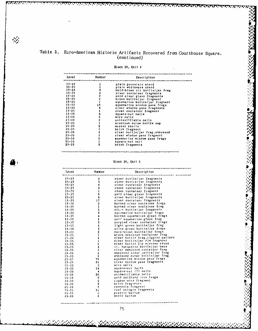
Table 3. Euro-American Historic Artifacts Recovered fron Courthouse Square.(continued)
Block 26, Unit 4
Level tNtznber Description
15-25 1 plain porcelain shard15-25 1 plain whiteware sherd15-25 2 mold-blown cir bottle/jar frog15-25 2 clear container fragments15-25 2 unid clear glass fragments15-25 1 brown bottle/jar fragment15-25 1 aquamarine bottle/jar fragment15-25 16 aquamarine window pane frogs15-25 4 clear window pane fragments15-25 1 clear container fragment15-25 4 square-cut nails15-25 2 wire nails r15-25 2 unidentifiable nails I.
15-25 1 aluminum screw bottle cap15-25 2 mussel shellsA15-25 1 brick fragment25-35 1 clear bottle/jar frog,embossed25-35 1 clear window pane fragment25-35 5 aquamarine window pane frags25-35 1 square-cut nail25-35 5 brick fragments
Block 26, Unit 5
-- - - - - -- -- - -- - -- - -- - -- - -- -- - -- - -- - -- - -- - -- - -- -
Level Nuniber Description
15-25 2 clear bottle/Jar fragments15-25 2 clear bottle/jar fragments a15-25 4 clear container fragments15-25 2 clear container fragments %15-15 1 clear container fragment '
15-25 8 unid clear glass fragments15-25 8 clear bottle/jar fragments15-25 17 clear container fragments15-25 2 burned clear container frogs15-25 1 burned clear container frog15-25 2 clf r bottle/jar fragments15-25 3 eqt,,marlne bottle/jar frogs15-25 4 burned aquamarine glass frags15-25 1 unhl aquamarine glass frog15-25 3 purpled clear container frags15-25 1 light green bottle/jar frag15-25 2 olive green bottle/jar frogs15-25 2 mold-blown bottle/jar frogs15-25 1 brown embossed container frog15-25 2 clear bottle frag,rlppled pattern15-25 1 clear bottle/jar rim fragment15-25 1 clear bottle lip w/crown close15-25 2 It. turquoise bottle/jar base15-25 1 clear embossed container frog
15-25 1 embossed clear jottle/jar frog
15-25 1 embossed clear bottle/Jar frag
15-25 76 aquamarine window pane frags
15-25 81 clear window pane fragments
15-25 2 wire nails
15-25 14 square-cut nails
15-25 4 square-cut (?) nails
15-25 30 unIdentIflable nails15-25 9 unId oxidized Iron frogs
15-25 1 copper wire fragment
15-25 9 brick fragments
15-25 I concrete fragment15-25 11 roof shingle fragments
15-25 1 plastic button
15-25 1 shell button
.... . --- - --- ----" -- , - , --' "- ~ -" ---- ---- ---- ----" ---- -'% - .- -X% .-, -- -'--'. ------------------------------------------------------------------------

Table 3. Euro-Anerican Historic Artifacts Rtecovered from Courthouse Square.(continued)
Block 26, Unit 9
Level Number Description
00-15 1 plain whitewere sherd000-15 a aquamarine window pane fregs
1- 1 2 cler window pane fragments00 -5 s brown bottle/jar fragments
00 -15 1 clear bottle/jar base fragment
Do0-15 1 clear container fragment
00 -15 3 square-cut nailIs00 -15 1 square-cut (-)nail
00 - 5 s unidentifiable nail
00 -1 s1 oxidized steel washer00- 15 1 unid oxidized Iron frag
00 -15 1 square-cut nail15 -24 2 plair: porcelain body sherds
15-24 8 aquamarine window pane frega
15-24 4 clear window pane fragments
15-24 1 burnedabottle neeh & Ilp frag
15-24 1 cler screw-top jar rim frag
15-24 2 clear container fragments
15-24 1 '1lear container fragment
15-24 4 brown bottle/jar base frags
15-24 1 brown bottle/jar base fragment
15-24 1 clear embossed bottle/jar frag
4. 15-24 1 cl er embossed bottle/jar frag
S15-24 2 cler emboasd bottle/Jar fraga
15-24 5 square-cut nails15-24 3 square-cut (?) nails
15-24 1 wire nail
15-24 1 unidentifiable nail
15-24 2 unid graphite objects
15-24 1 brick fragment
15-24 26 asbestos roof shingle frags
15-24 1 plastic button
15-24 2 mussel shells
24-35 1 yellowish glazed stoneware sherd
24-35 1 burned opaque marble fragment
24-35 1 burned unid glass fragment
24-35 1 clear container fragment
24-35 1 ember container fragment
24-35 1 clear container fragment
24-35 2 clear window pane fragments
24-35 1 aquamarine window pane frsg
24-35 1 aquamarine container rim frag
24-35 2 square-cut nails
24-35 1 unidentifiable nail
24-35 3 asbestos roof shingle frags
76 K
%V.
-*'g """ " . ". -" " " 2"J-'".-,." -" . -'-" .'2' . ", " 22€- "' ' "- ". "-'""" " " " " •" " ' """ '" •".- """" - - "." " -
. , a:.. "' - - ' - . - . , -,, i=, ,- ;="' . ..""" -" ' ,-- b~ "" 'G di ".... .... .'" % " '' ',.'.',-' '.'',,"'
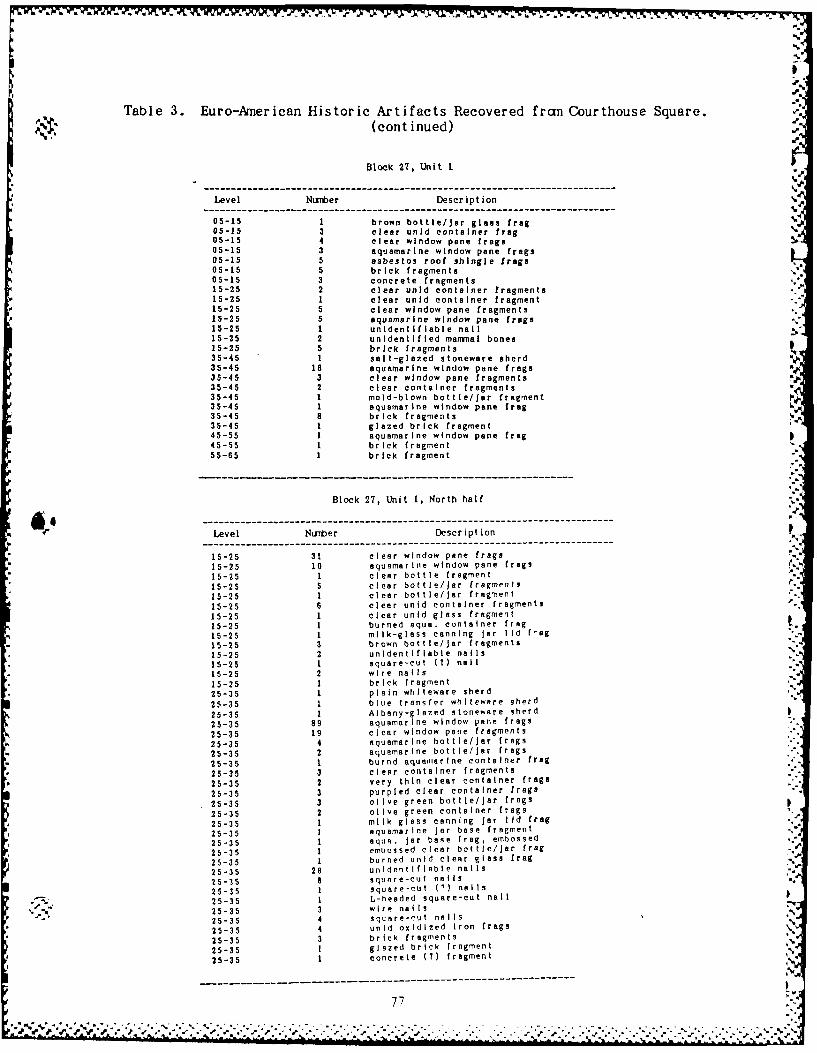
01
Table 3. Euro-American Historic Artifacts Recovered fran Courthouse Square. P
(continued)
Block 27, Unit 1
Level Numrber Description
05-15 1 brown bottle/jar glass frog05-15 3 clear unid container frog
05-15 4 clear window pane frogs
05-15 3 aquamarine window pane frogs
05-15 5 asbestos roof shingle frogs
05-15 5 brick fragments
05-15 3 concrete fragments
15-25 2 clear unid container fragments
15-25 1 clear unid container fragment
15-25 5 clear window pane fragments
15-25 5 aquamarine window pane frogs
15-25 1 unidentifiable nail
15-25 2 unidentified marmal bones
15-25 5 brick fragments
35-45 1 salt-glazed stoneware sherd W%
35-45 18 aquamarine window pane frogs
35-45 3 clear window pane fragments
35-45 2 clear container fragments
35-45 1 mold-blown bottle/jar fragment
35-45 1 aquamarine window pane frog
35-45 8 brick fragments35-45 1 glazed brick fragment
45-55 1 aquamarine window pane frog P45-55 1 brick fragment
55-65 1 brick fragment
Block 27, Unit 1, North half............................................................................-Level Nuarber Description ,0
15-25 31 clear window pane frogs
15-25 10 aquamarine window pane frogs
15-25 1 clear bottle fragment
15-25 5 clear bottle/jar fragments
15-25 1 clear bottle/jar fragment
15-25 6 clear unid container fragments
15-25 1 clear unid glass fragment
15-25 1 burned aqua. container frog
15-25 1 milk-glass canning jar lid f'ag
15-25 3 brown bottle/Jar fragments
15-25 2 unidentifiable nails N
15-25 1 square-cut (?) nail
15-25 2 wire nails
15-25 1 brick fragment
25-35 1 plain whlteware sherd
25-35 1 blue transfer whlteware sherd
25-35 1 Albany-glazed stoneware sherd
25-35 89 aquamarine window pane frogs
25-35 19 clear window pane fragments
25-35 4 aquamarine bottle/jar frags
25-35 2 aquamarine bottle/jar frogs
25-35 1 burnd aquamarine container frog
25-35 3 clear container fragments
25-35 2 very thin clear container frags
25-35 3 purpled clear container frogs
25-35 3 olive green bottle/jar frogs
25-35 2 olive green container frogs
25-35 1 milk glass canning jar lid frog
25-35 1 aquamarine jar base fragment
25-35 1 aqua. jar base frog, embossed
25-35 1 embossed clear bottle/jar frag
25-35 1 burned unid clear glass frog
25-35 28 unidentifiable nails
25-35 8 square-cut nails
25-35 1 square-cut (9) nails
25-35 1 L-headed square-cut nail
25-35 3 wire nails
25-35 4 square-cut nails
25-35 4 unid oxidized Iron frogs
25-35 3 brick fragments
25-35 I glazed brick fragment
25-35 1 concrete (7) fragment N
77

'V
Table 3. Euro-American Historic Artifacts Recovered frcm Courthouse Square.(continued)
Block 27, Unit 1, South half
Level Numiber Description
05-15 2 unid oxidized steel disks05-15 1 wire nail05-15 1 square-cut nail05-15 1 emall I-beam fragment15-25 1 clear bottle/jar base fragment15-25 1 clear bottle/Jar frag,embossed15-25 1 burned brown glass fragment15-25 3 brown bottle/Jar fragments15-25 1 clear embossed bottle/jar base15-25 5 clear bottle/jar fragments15-25 3 clear unid container fragments15-25 35 clear window pone fragments15-25 11 aquamarine window pane frogs15-25 5 wire nails15-25 1 wire (?) nail15-25 1 unid iron wire fragment15-25 1 unid Iron fitting,brass end15-25 3 asbestos roof shingle frogs15-25 1 concrete fragment15-25 13 brick fragments15-25 1 concrete (?) fragment25-35 2 plain whiteware sherds25-35 1 plain whiteware base sherd (cup)25-35 40 aquamarine window pane frogs25-35 17 clear window pane fragments25-35 1 purpled clear bottle neck frog
25-35 4 purpled clear container frog25-35 10 clear container fragments25-35 1 clear container fragment25-35 1 opaque white container frog25-35 13 clear bottle frags,same vessel25-35 1 clear bottle/Jar lip fragment25-35 1 clear cup? rim fragment25-35 4 clear container fragments25-35 1 aquamarine container fragment25-35 1 aquamarine bottle neck,burned?25-35 1 aquamarine jar base, embossed25-35 1 aqua. Jar base frog, + (58-91)25-35 4 unid clear fragments25-35 3 unid clear fragments25-35 4 square-cut nails25-35 2 wire nails25-35 3 square-cut (?) nails25-35 15 unidentifiable nails
----------------- ------------ ---- --------- ----------------------------
.N
78
5' j~ " ' - : . € . - . ; . .
.--.- .-.. . - . -. ,... ". _

S...
Town West of the Courthouse (Figure 31)
Documentary, cartographic, and oral historical sources indicated that theseveral blocks west of the courthouse had been used extensively since themid-19th century as a place for both residences and businesses. In order todetermine the nature of the deposits in this area a program of systematicshovel testing was conducted. A grid was established which we believedapproximated the streets on the 1890 Plat and 31 shovel tests were placedwithin this grid.
The shovel tests measured approximately 30/40cm in diameter and all but 1was dug into the B horizon. All matrix from these tests was sifted through1/4 inch hardware cloth. The profile of each of these units was recorded ingeneral terms (Table 4).
Shovel Tests I through 24 were placed in the two city blocks west of thecourthouse square, that is the blocks bounded by Jackson, Jefferson, Grant,and Lincoln Streets. A total of 12 lots were platted in these blocks and 2shovel tests were placed in each lot (Figure 31). These units were placed
'4- in a consistent grid over the blocks except where existing concrete'. structures or roads made this impossible. The shovel tests are located 5m
west of each lot boundary at 14 and 44 feet south of the north lot border.Shovel test 5 was assigned a number but was not excavated because of itslocation within the park pavillion.
Shovel Tests 25, 26, and 27 were located 15m west of Grant Street on anorth-south line. These units are 10, 20, and 30m south of the southernlimit of Lincoln Street.
Shovel tests 28 through 31 were located north of the courthouse square on anorth-south line 100 feet east of the western edge of the lots borderingJackson Street. These units were excavated at 25, 75, and 125 feet north ofthe northern edge of Lincoln Street. Shovel test 31 was excavated 50 feetwest of Shovel Test 30. This was done so that all lots in the block boundedby Jackson, Swan, Benton, and Lincoln Streets would contain 1 shovel testunit. The 2 lots not tested are presently covered by concrete andstructures.
All 31 shovel tests reached the B horizon except for Shovel Test 31 whichencountered large blocks of broken concrete 10cm below the surface. Theblocks were too large to excavate in a shovel test unit. Also they appearedto be over very loose soil (possibly a hole) and the possibility of this
unit being over a collapsed septic tank was raised.
79
'Ol *IK

Lii
4.n.
L--j -i LL J Pd
m EPWLW LL
0 0 0 0jD. .5
II 4.
_ _ _ _ _ _ __ck
E: Li-
=0 0
!.441

- -i4. . -
Table 4. Shovel Tests: Euro-Arnerican Artifacts and Stratigraphy.
Shovel Test I SHOVEL TEST I
Depth (cm) Soil Description NUMBER DESCRIPTION
3 clear bottle frags, joinable2 unid rusted Iron frags %
0-20 gravel layer 1 square-cut(?) nail20-33 mixed A/B soil 1 wire nail33-35+ B21 horizon I wire (?) nail
1 unid nail
Shovel Test 2 SHOVEL TEST 2
........-----------------------------------------------------------
Depth (cm) Soil Description NUMBER DESCRIPTION----------------------------- -------------------------------------------------------------- i............................................ 1 plain whiteware rim sherd
I dark blue bottle glass0-10 topsoil I clear window pane fragment
10-3, B21 horizon It. green window? glass frag37+ natural gravel layer I unid fired clay fragment
---------------------------------------------------------------------------------------- -----------------------
Shovel Test 3
Depth (cm) Soil Description
0-15 topsoil
15-47 B21 horizon47-50+ natural gravel layer
V.
I.
Shovel Test 4 SIlO/EL TEST 4
.. .. .. . .. .. . .. .. .. . .. .. . .. .. .NUM8IER DESCRIPTION
Depth (cm) Soil Description ---EIO2 plain wniteware sherds2 brown bottle/jar fragment
0-15 topsoil I burned dark-green glass frag
15-40 mixed A/B soil 2 aquamarine window pane fragmnt
40-44+ B21 horizon (charcoal and I aqua.bottle neck w/applied lip
chalk present) 2 square-cut nails5 square-cut (M) nails
-- - - - - - - -- - - - - - - -- - - - - - - 8 unidentified nails
21 unid oxidized iron frags %
81 "
------ ---------------------------------------------------
• " - " -" '= -,' .',S#Z ' € '.' -, .'.''. '.''.'.' ' % -' "." " ' '.-.,% '.. . ."." .. .- , .. . . . ."'%

Table 4. Shovel Tests: Euro-American Artifacts and Stratigraphy.(continued)
Shovel Test 6............................................-
Depth (cn) Soil Description
0-16 topsoil16-43+ B23 horizon
Shovel Test 7 SHOVEL TEST 7
Depth (crm) Soil Description NUMBER DESCRIPTION
I plain white porcelain rim shrd0-10 topsoil plain white porcelain bdy shrd
10-25 mixed A/B soil I plain whiteware sherd-25- ied hsori 1 earthenware bdy shrd w/red glz25-83 B21 horizon 1 banded 'lusterware' rim sherd
83-85+ B22 (?) horizon (gravel 1 aqua. milk bottle? rim fragand clay present) 1 cr bottle neck w/applied lip
% I aquamarine Dottie neck frag---------------------------------------------. 1 aquamarine bottle fragment
2 aquamarine bottle/jar fragsI aquamarine plate glass frag
.. clear window pane fragment1 purpled clear bottle fragment
- 2 unid oxidized sheet metalI wire nailsquare-cut (?) nail
- 2 unidentifiable nails
-----
Shovel Test 8 SHOVEL TEST 8-----------------------.-----------------------
Depth (cm) Soil Description NUMIER DESCRIPTION--------------------------------------------- whit--------are--- b d ------ h----------r-----------s
3 plain whiteware body sherds• 010 opsilI plain whiteware rim sherd0-10 topsoi I I clear window glass fragment
10-34 mixed A/B soil 1 aquamarine window glass frag34-43+ B21 horizon 2 clear bottle/jar fragments
1 clear bottle/jar base fragment--------------------------------------------- 1 aquamarine bottle/jar fragment
I aquamarine jar frag, embossed2 wire no ai Is2 square-cut nailsI unid oxidized nail2 unid badly oxidized nails1 twisted wire fragment1 unid oxidized Iron frog
S .. , I oxidized sheet metal fragI'. 1 oxidized metal can frogI red coarse brick fragment1 mussel shell fragment
P2
.- *P.. '
Table 4. Shovel Tests: Euro-American Artifacts and Stratigraphy.(continued)
Shovel Test 9 SHOVEL TEST 9-------------------------- ---------------------------------------- P
Depth (cm) Soil Description NUMBER DESCRIPTION
-------------------------- ---------------------------------------
1 plain whiteware sherd %
-0 opoi clear window glass fragment0-10 topsoil I clear window glass fragment10-40 mixed A/B soil 1 aquamarine window glass frag40-50+ B21 horizon 1 aquamarine window glass frag
2 aquamarine bottle/jar fragmentI aquamarine bottle baseI light blue glass fragment1 dark green plate glass frag
3 clear bottle/jar fragments1 purpled clear glass rim frag
1 clr bottle frg w/red&ylw label1 clear frag, oil lamp cover rim
clear screw-top jar rim2 wire nails V'.3 square-cut nails "-
2 unidentifiable nails6 unidentifiable nails1 burned bone fragment
-------------------------------------------------- - - - -------------- -- --
SHOVEL TEST 10Shc vel Test 10
D' pth (cm) Soil Description NUMBER DESCRIPTION
I burned plain whiteware sherdI burned plain whiteware rim shd
0-10 topsoil 3 plain whiteware sherds10-37 mixed AiB soil I plain yellow-ware sherd37-43+ B321 horizon I brown bottle jar fragment
I clear window glass fragment----------------..--------------------------- 1 1 clear w indow glass fragment
1 aquamarine window glass fragI wire nail
10 square-cut nails1 rusted metal fragmentI iron mule (?) shoe3 large mammal bone f rags
Shovel Test It SIIOVEL TEST 11
Depth (cm) Soil Description NUMBER DESCRIPTION
..................................-... clear.b1 clear bottle/jar frag,embosse.'-. '"0-13 topso i I clear bottle/jar frag,embossed
-13tops i 1 unidentifiable nail_%13-23 mixed A/B soil 11 bone fragments23-38+ B21 horizon ,
....%
83

'a .
Table 4. Shovel Tests: Euro-Anerican Artifacts and Stratigraphy.(continued)
Shovel Test 12 SHOVEL TEST 12
Depth (cm) Soil Description NUMBER DESCRIPTION
............................................ 1 I clear window fragment
I clear bottle/jar fragment0 Iwire nail
10-20+ B23 horizon I square-cut nail
hovel est 13SHOVEL TEST 13
Depth (cn) Scil Description NUMBER DESCRIPTION
- - - - - - -- - - - - - - - - - - - - - - -2 plain whiteware sherds (plate).2 unid opaque white glass frog
0-0 topso il 2 milk glass canning jar lid frg10-40 gravel and large concrete 1 clear bottle/jar? frog %
blocks I canning jar? frog, "D11 present'%40-80 B21 hor izon mixed with 2 wire (?) nails
some charcoal and Fe I square-cut (?) nail,,7unidentifiable nails
---------------------------------------------.. badly oxod ized boltI box knifeN
6 unid oxidized metal frogs1 shell (?) fragmentIroof shingle (M) fragment .,,.
'-
SHiOVEL TEST 14 "=
Shovel Test 14
NUMBERDESCRIPTION
Depth (cm) Soil Description NUMBER
2 plain whiteware base d (cup)
I screw-top canning? jar frog .2 brown bottle/jar fragments a
0-10 topsoil clear bottl e/Jar frg, embossed10-30 gravel layer I clear container base, jar/bowl30-50 mixed A1B soil I aquamarine bottle? fragment50-73 B21 horizon with some unid lear container fragments
charcoal flecks 2 clear plate frogs, embossed ,
73-80+ B21 hor izon with smnallI I aquamarine window glass frog ,.
F n flecks, infrequent 1 aquamar ine window glass frog.I melted aquamarine plate glass,.
s-ne-charcoal-and------ -2 square-cut nails
I wire nail "
1 wire M? nail "
2 wire nails4 unidentifiable nails
' , 1 unid large Iron frngment,,2 oxidized wire fragment7 unid badly oxidized metal '
---------------------------------------- ----------
84I

Table 4. Shovel Tests: Euro-American Artifacts and Stratigraphy.
(continued)
Shovel Test 15 SHOVEL TEST 15 .
-------------------------- ---------------------------------
Depth (cm) Soil Description NUMBER DESCRIPTION--------------------------------------------------- ------------------- -
I clear container fragment
1 clear window glass fragment0-15 topsoil wire (?) nail
15-30 gravel layer 1 large mammal bone
30-50 mixed A/B soil
50-55+ B21 horizon with small ----------------------------------------------------FeMn flecks r
Shovel Test 16 SHOVEL TEST 16------------------------------------------------------- ----------------------------------------------------
Depth (cm) Soil Description NUMBER DESCRIPTION--------------------------------------------------------- -------------------------------------------------
plain whiteware sherdbrown bottle/jar fragment
0-10 topsoil 1 clear bottle/jar fragment10-15 gravel layer 1 unid oxidized metal frag
15-30 mixed A/B soil unid metal fragment
30-79 mixed A/B21 soil I square-cut nail79-80+ B21 horizon
Shovel Test 17 SHOVEL TEST 17 '
-------------------------------------------------------- ----------------------------------------------------
Depth (cmn) Soil Description NUMIBER DESCRIPTION
1 plain whiteware body sherdI aquamarine bottle/jar fragment
0-0 topsoil I wire nail10-12 B22 horizon()Iund tfabeai
12-30 mixed A/B soilIund tiabeal
30-58 mixed B21/A soil58-61+ B21 horizon
Shovel Test 18 SHOVEL TEST 17
... .. ... E.... .. ESC.. ... .PT.. .ON.
Depth (cm) Soil Description NMBER DESCITI ON
------------------------..------------------------------------------------------------------------I clear window pane fragment
% 0-13 topsoil I aquamarine window pane fragn% %= 13-42 mixed A/B21 soil I aquamarine container fragment
42-48+ B21 horizon with smaII I clear container fragment
Fe n flecks 4 roof shingle (?) [rags
-p
---------------------------------------------- -----------------------------------------------------
Deph (m) oilDesripionNUMER ESCII85O

I
Table 4. Shovel Tests: Euro-American Artifacts and Stratigraphy.(continued)
Shovel Test 19 SHOVEL TEST 19
------------------------------------------------------ -------------------------------------------------
Depth (cm) Soil Description NUMBER DESCRIPTION--------------------------------------------- I burned plain whiteware bdy shd
1 aquamarine container fragment0- 8 topsoiI I green bottle glass fragment
8-15 gravel layer 2 square-cut nails
15-30 mixed A/B21 soil 2 square-cut (?) nails
30-43+ B21 horizon 2 unidentifiable nails *
Shovel Test 20 SHOVEL TEST 20.?
Depth (cm). Soil DescriptionNIERDCRTON '
I burned plain whiteware bdy shd %%'
2 unid clear container fragment0-0 topsoi 1 5 unid oxidized metal frags .
10-25 mixed A/B soil I rusted wire (?) fragment25-30+ B21 horizon I wire nail"
I unidentifiable nail
Shovel Test 21 SHOVEL TEST 21
I plie naite aesh r
0-1 unidi1c erni oiab l ai s framen
1ellf3043 B o"
I cle r bo tle/jr frgmen
---- --- --- ---- --- --- --- ---- --- --- -- 1bur ed , cle r bo tle jar fra1 le d fi hin wei ht* N5..
4 wire nail
2 unedtipianwhlae bdil sh
0e, tosi Jrndcea.otierfamn

Table 4. Shovel Tests: Euro-American Artifacts and Stratigraphy..- (cont inued)
Shovel Test 22 SHOVEL TEST 22
Depth (cm) Soil Description NIIBER DESCRIPTION
4 plain whiteware sherdsI plain whiteware sherd (cup)
0- 5 topsoi 1 plain whiteware rim serd5-10 gravel layer 2 repousse whiteware rim sherd
10-20 A horizon 2 plain whiteware w/maker'3 mark20-40 mixed A/B21 soil I green-glazed earthenwre i/mark
40-53+ B21 horizon with Felvn 1 clear window glass fragmentflecks I clear glass marble
1 clear glass bottle baseI It. aquamarine bottle fragment
I unid clear glass fragment11 wire nails2 wire (?) nails
2 unidentifiable nails1 bolt (5.30 cm long)I clothes pin metal springI unidentifiable metal frag1 metal end of pencil (?)
1 brass-pltd ornamentl disk
I Irg mammal bone, leg part 0
Shovel Test 23 SHOVEL TEST 23
Depth (cm) Soil Description NMBER DESCRIPTION----------------------------------------------------- ----------------------------------------------------- '
1 plain whiteware rim shd (bowl)2 plain whiteware bdy shds (cup)
0- 5 topsoil I plain white porcelain base shd
5-28 mixed A/B soil 1 aquamarine screw-cap jar frag28-51+ B21 horizon 2 aquamarine bottle/jar frag
2 unid clear container fragmentI unid It. green glass fragment
I wire nailI wire (?) nail3 unid oxidized metal frag1 copper wire bundle1 unid crushed aluminum (?)
Shovel Test 24 SHOVEL TEST 24
--------------------------------------------------- -----------------------------------------------------
Deph (m)NUMBER DESCRIPTIONDepth (cm) Soil Description
--- --- --- --- --- --- --- --- --- --- -- -- --- --- --- --- ------ --- --- ------------------- - - S
3 burned plain whiteware Frags1 clear container fragment .
0-10 topsoil 3 purpled bottle frags, lip&neck J.10-30 mixed A/B soil with 2 wire nails
building stones present 2 wire ?) nails30+ B21 horizon I wire nails
1 unidentifiable nail""- --------------------- 2 unid oxidized metal frags
I unid Irg mammal bone frag"S
87
% %

Table 4. Shovel Tests: Euro-American Artifacts and Stratigraphy. Id'*-" ~( cont inued )":-"
Shovel Test 25 SHOVEL TEST 25
Depth (cm) Soil Description NUMBER DESCRIPTION
clear container fragmentsquare-cut nail (broken?)
0- 8 topsoil 1brick fragment8-25 mixed A/B soil b r25-30+ B21 horizon woth Fe1n
flecks
,----
Shovel Test 26 SHOVEL TEST 26
Depth (cm) Soil Description NUMBER DESCRIPTION
----------------------- ----------------------------------------------2 unid oxidized Iron frags
0- 5 topsoil5-15 mixrd A/B soil ---------------------------------------------------
15-28+ B21 horizon with FeMn %flecks .---------------------- - %i
Shovel Test 27 SHOVEL TEST 27
Depth (cm) Soil Description NUMBER DESCRIPTION--------------------------- ----------------------------------------
1 clear screw-cap jar rim trag1-6tpo square-cut nail
0- 6topsil 1concrete fragment6- 8 i n situ painted stone 1brick or tile fragment
flIoor 1brick (?) fragment8-12 mixed A/B soil
12+ B21 horizon
iS
Shovel Test 28 SIIOVEL Tflql :
Depth (cm) Soil Description N'tBER Pi
I pl!in , t .a o -, t
0-12 topsoil 2 5,.
12-35 mixed A/B soil 135-37+ B21 horizon with nunerous I-
F61n flecks 4
2

AD- RM M 3 ON CEOLI L C O S HIST OIC L M INVE TI ONS OLD FORSYTH 2/22SITE (23T841) TOL.- (U) ARCNOLOOICAL RSSESSIENTS INCMRWILLE U J WUETT ET AL DEC 97
I:M;lRSFlE D OOLIcL RSSSST-F/0 5/ NL
E1EhhhEh
ELo EEonhh

k. ilil 2
,Ile %.%J,* % % %
11%Lot%

Table 4. Shovel Tests: Euro-Amnerican Artifacts and Stratigraphy.(continued)
Shovel Test 29 SHOVEL TEST 29------------------------------------------------------------------------- ------------------------ ---Depth (cm) Soil Description NUMBER DESCRIPTION
---------------------------------------------. 1 white porcelain sherd, glazed1 clear bottle frag, mold blown
0-12 topsoil 3 square-cut nails12-45 mixed A/B soil 1 square-cut (?) nail45-53+ B21 horizon with small 2 unid oxidized iron frags
FeMn flecks I unid oxidized Iron frag4 2 brick fragments
- - ------------------------------------------ I brick frag w/mortar adher1 mammal leg bone, burned?5 mammal bone fragments1 tooth, herbivore molar
Shovel Test 30 SHOVEL TEST 30
(-------------------------------------- -NUMBER aumrn DECRPTON (a* Depth (cm) Soil Description NUMBER---S-------------...-.--- .. ----..-- ... .... .... ... 1 aquamarine screw-top jar frag
I clear window glass fragment0-12 topsoil with gravel square-cut (?) nail12-28 B21 (?) horizon28-34+ B23 horizon burned ?) bone fragment
-------------------------------------------------------------------------------------------------
Shovel Test 31 SHOVEL TEST 31
Depth (cm) Soil Descr ipt ion NUMBER DESCRIPTION
I aquamarine window pone frag., I clear window pane fragmentNo profile taken - rock I clear window pane fragment
an ocee nonee 2 brown bottle glass fragments, I aquamarine bottle/jar fragment
-- - - - - - -- - - - - - - - - - - - - - -I clear bottle lip & part neck ,3 wire nailsI oxidized steel can base
'% 1 oxidized snap closureS5 unid oxidized Iron frags
7 oxidized steel wire frags%2 automobile tire fragments
------- - ,-- ----
J, - '1 Wo-. I

The Ice House Locality (Figure 32)
Three test units were placed in the vicinity of the Ice House, primarily tolook for evidence related to the use of the Ice House itself which served asa focal point for leisure time activities (Figure 33) and to check forevidence related to the reported Historic Period Indian burial from thisarea.
Ice House Test Unit 1 was a narrow trench, .5 x 2m, set at a right angle tothe concrete footing which marked the southeast corner of the Ice House.The profile of this unit (Figure 34) revealed a silt loam horizon to a depthof 20cm. The well-developed B horizon was cciposed of an upper and lowerunit and was devoid of Euro-American Period artifacts although someprehistoric artifacts were recovered here. Two other small, .5 x .5m,probes were located in this area. In both of these the A horizon extendedto approximately 20cm with evidence of the gravel thought to have been usedwhen the park was landscaped in Ice House Test Unit 2. The B horizons inthese units were also well-developed and very few Euro-American artifactswere recovered below the A horizon in either unit (Table 5).
Local informants, present during excavation, told us that when the Ice Housewas removed that a considerable amount of heavy equipment work was done atthis location. We strongly suspect that the soil layers related to the use* of the Ice House have been removed. No evidence to suggest the presence ofadditional grave locations was recovered.
N'.
90

(Y)
0 4
4-r
4-4 4-
0
4-J 6
'-:-
91
.A A.

a~4*f
S.--CE
.1'*
J1.
., Finure 3. Photoqraphs of the Ice House~ (Edom and Fdom 19R3: 35)
92

Ice House Test Unit 1Ea~st W/att
5of Root and Gravel Zone F771
IOYR3/4 sitt loaml organcmaeros present Unexcovated
2Ocm
IOYR4/3 slt Loam
40cm 10cmIOYR3/4 heavy silt LoIam
Ice House Test Unit 3 Ice House Test Unit 2North Watt North Wa/ot
Root5er~ Root Zone5cm - o±Zn c Root Zone 5c.
1OYR4/4 heavy silt Loam Gv Zorganic stains present Gr{vet Zone
17cm 21cm
IOYR3/3 heavy silt Loam IOYR3/3 silty clay
Figure 34. Ice House Units, 1, 2, 3: Profiles
93
MW ITA l~ AAVNU WAMA11IlJ9 RM~ NU~~l~ f 7 .'2 ~L
Table 5. Euro-American Artifacts Recovered from Icehouse Test Units 1, 2,and 3.
Icehouse Test Unit 1 I----------- ----------------------------------------------------------------------------
Level Number Description------------ ---------------------------------------------------------------------------00-2O 1 white porcelain,part of toy?00-20 5 unld clear eontainer fragments00-20 1 unld clear glass fragment
00-20 1 elear glass container frag00-20 2 bright green bottle fragments
00-20 5 brown bottle glass fragments00-20 4 clear bottle/jar glass frags00-20 1 steel can rim fragment00-20 1 wire nail00-20 1 unidentifiable Iron frog15-25 3 clear window pane fragments20-30 1 unid clear glass fragment20-30 1 brown bottle glass fragment20-30 1 unidentifiable nail20-30 3 mussel shell fragments20-30 1 concrete/mortar fragment30-40 1 brown container glass fragment30-40 1 brown container glass fragment30-40 1 small caliber bullet casing30-40 2 asbestos roof shingle frag30-40 2 mussel shell fragments
Icehouse Test Unit 2
Level Number Description
00-25 1 ler glass bottle/jar free00-25 1 clear glass bottle rim frag
00-25 4 brown glass bottle fragments00-25 1 brown bottle base frag, embossed00-25 1 brown bottle neck & lip00-25 1 unidentifiable lead frag00-25 2 brick fragments ./
e
Icehouse Test Unit 3
Level Number Mlscriptlon
00-15 20 brown bottle/jar glass frogs00-15 4 brown bottle/jar base frags *100-15 7 clear bottle/jar fragments00-15 5 clear container fragments00-15 1 clear container fragment00-15 1 burned bright green unid frag 500-15 1 burned brown glass fragment00-15 1 burned aquamarine? fragment00-15 1 unid brown glass fragment00-15 4 unidentliflable nails00-15 2 wire (M) nails15-25 1 unld clear glass container frag15-25 2 unidentifiable nails15-25 2 brick fragments.- 25-35 3 brown bottle/jor fragments -
25-35 I clear bottle/jar fragment 525-35 1 clear unid container fragment25-35 1 brown bottle/jar base fragment35-45 1 brown bottle/jar base fragment
94
rV 1.e -. *-.*
%rj
U WU . VWU WVJ V%.. VV VUP NdkA .WRI T% VK X UT ill XLR 10 ~~V N ~ -P~ '~P'J ~ P~T
ELMK-AMERICAN ARTIFACTS
,hr ongo gy
During the course of the 1986 excavations numerous artifacts from the 19th
and 20th century occupation of the site were recovered. Listings of these
items have been given with their provenience discussions (Tables 2 - 5). In
this section an attempt is made to consider the chronological range of these
materials. Table 6 presents a sunrnary of those Euro-American artifac.s for
which we were able to formulate chronological estimates. Dates which areunderlined in Table 6 are those which we believe, generally following Derven
(1977), are the most likely period of use for the items described. Figures
35 - 37 illustrate a number of these diagnostic materials. Our discussion
of the Euro-American artifacts concludes with a consideration of the nails
and window glass recovered from the site.
TABLE 6. CH1a4LO3ICALLY DIAGCOSTIC MATERIALS
Description Date Range Reference
------------------------------------------------------------------------'Purpled' clear glass Pre-1915 Wallis 1983:121 e
bottles with applied 1880-1913 Newnan 1970:72
lips, made by a semi- 1889-ca. 1926 Miller and Sullivan %
automatic bottle machine 1981:16
bottle machine(Figure 35a,c,d)
Clear glass bottle frag- 1850-1913 Newnan 1970:74
ment with applied lip Post ca. 1850 Lorrain 1968:40
(Probably mold-blown)
Machine-made screw-top Post-1881 Wallis 1984:159
jar rim, non-ground Toulouse 1977:103
Mold-blown bottle neck 1840-1913 Newnan 1970:72,74 Iwith applied lip (probably
a two-piece mold, possibly
blown in a semi-autanaticbottle machine(Figure 35b)
95 1
TABLE 6. CHRWLCOGICALLY DIANIC MATERIALS (continued)
Description Date Range Reference
Brown, embossed bottle semi-autanatic: Miller and Sullivanbase made in an auto- 1889-ca.1926 1981:16matic or seri-autcmatic autcnatic: 1904- Miller and Sullivanbottle machine. Embossed present 1981:16label on base: BALL. semi-autanatic: Newnan 1970:72-73
1880-1913autaoatic:1903-present Newnan 1970:73Date frcm makers mark Toulouse 1971Post-1893
Brown bottle neck and 1920-present Newnan 1970:72lip made in an auto- 1904-present Miller and Sullivanmatic bottle machine 1981:16
Clear, embossed bottle/ 1903-present Newman 1970:73jar base (has an Owens 1903-present Miller and Sullivan
ring) made in an auto- 1981:16matic bottle machine
Aquamarine bottle neck 1840-1913 Newnan 1970:74 %
with a hand-finished lip.Bottle is mold-blown.
Aquamarine jar base 1902-1964 Toulouse 1977:71 0embossed with 'Sanford'Made by Sanford Mfg. Co.(Hazel-Atlas Glass Co.)
Clear bottle lip with 1920-present Newnan 1970:72probable crown-type 1903-present Miller and Sullivan Sclosure. Made in an 1981:16automatic bottle machine
Clear container embossed possible date: 189?with '189'
Zinc canning lids Patented 1858 Lorrain 1968:40 r
Milk glass lid liner Glass lid under zinc Toulouse 1977:135cap patented 1869
96

TABLE 6. GF)LOGICALLY DIAGNOSIC MATERIALS (continued)
Description Date Range Reference
Plain whiteware 1813-present Derven 1980:139(numerous examples) 1850.1900
ca. 1850-1890 Price 1979:30-33
Repousse (relief- 1820-1900+ Derven 1980:135molded) whiteware 1860-1900
1830-1845+ Price 1979:30-33
Plain yellow-ware 1820+ - 1930 Derven 1980:1391860-1900
Repousse' (relief- 1780-1840 Derven 1980:139molded) pearlware (?) 18001840
1810-1830 Price 1979:30-33
Blue shell-edged 1830+ - 1860 Derven 1980:123,129whiteware 1830-1860 Price 1979:30-33
aBanded luster decorated 1820-1900+ Derven 1980:132
whiteware rim sherd 1850-1890 Maiewski and(handpainted), overglaze O'Brien 1984:116
Wallis 1984:132-136
Blue (monochrome) trans- 1780-present Derven 1980:138fer-printed whiteware 1800-1860
1825+ - 1860+ Price 1979:30-33
Blue (monochrcme) trans- 1790-present Derven 1980:138fer-printed whiteware 1800,1860+(parttof maker's mark 1825+ - 1860+ Price 1979:30-33 mpresent)
Brown (monochrane) trans- 1780-present Derven 1980:138fer-printed whiteware 1800-1860,+ ,.
1825+ - 1870+ Price 1979:30-33I
Red (monochrome) trans- 1780-present Derven 1980:138fer-printed whitewure 1800,1860+
1825+ - 1870+ Price 1979:30-33
Green (monochrae) trans- 1780-present Derven 1980:138 Ifer-printed whiteware 1800-18-60+rim sherd 1825+ - 1870+ Price 1979:30-33
97
1 r r - V

TABLE 6. (2MUL'OICALLY DIACNISrIC MATERIALS (continued)
Description Date Range Reference
Red Sponge-decorated 1830-1900+ Derven 1980:136whiteware 1850-189(Figure 36b) 1835-1870 Price 1979:30-33
Purple-blue Sponge- 1830-1900+ Derven 1980:136decorated whiteware 1850,1890
1835-1870 Price 1979:30-33
Salt-glazed stoneware 1800-1880+ Derven 1980:140pre,1840
Albany-slipped (opaque ca.1830-ca.1910 Derven 1980:123dark brown) stoneware
Bristol-glazed (opaque 1835-present Derven 1980:142tan) stoneware
Brass-plated disk made Post-1893 Schroeder 1971by Sears and Roebuck,Chicago, Illinois
Steel can rim fragments Post-1818 Rock 1984:101
Crown-type bottle cap Patented 1892 Lorrain 1968:42fragments
Wire nails 1850-present Fontana and Greenleaf19-p n 1962:54-55
Square-cut nails 1790-present Fontana and Greenleaf I(Figure 37) (rare after 1900) 1962:46-50, 54-55
1850-1890 "
Square-cut nails 1830-present Fontana and Greenleaf(machine-made heads) (rare after 1900) 1962:51, 54-551850-1890
L-headed square-cut nail 1800-1850's Fontana and Greenleaf(Figure 37g) 1962:46, 51, 54-55
98

1.11 .-- - - - - - -. .- .. ,.. . . . . . . . .
TABlE 6. CEMNOLmICALLY DIALIOSTIC MATtRIALS (continued)
Description Date Range Reference 01%
Plastic button 1900-present Lees 1977:78 QuotesNewberger 1944:2
Shell button Post-1866 Lees 1977:78 QuotesNewberger 1944:2
British (?) gunflint 1780-Present Sudbury 1976:35If British, earliest ref. Quotes Witthoftdate is about 1780. Can 1966:34-36still be bought today.(Figure 37j)
As Table 6 shows there are relatively few different items present whichcould be securely dated to the early or middle portions of the 19th century.Those items which we feel are most likely to be survivors of that period ofthe site's use are the various forms of decorated whiteware and the L-headedsquare nail. The British gun flint is also a good candidate for a Civil WarPeriod artifact but we cannot be certain of this. The majority of materialsrecovered in the 1986 excavations fall within the mid to late 19th centurywith a number of materials in use during the first half of the 20th century.In general terms, this chronological range accords very well with thatpresent in the materials recovered during the 1980 and 1984 excavations(Turner and Purrington 1980; Benn 1984). Table 7 presents the chronologicalrange of materials in a somewhat more graphic format.
In considering the distribution of those items of possible early or middle19th century use we find that they come almost entirely from the excavations Sat the southeastern portion of the site. It was also in this area that theCenter for Archaeological Research investigations recovered similarmaterials. Investigations at the Ice House area recovered no ceramics. .sWhile a number of ceramics were recovered from the shovel testing west ofthe courthouse square only 1 of these items was clearly early; a piece ofbanded lusterware. Three pieces of decorated whiteware were recovered fromthe courthouse square. Table 8 illustrates the distribution of recovered 0%ceramics. 1
To surmarize, we can say that while artifacts from the early and mid-19thCentury were recovered they make up a rather small percentage of the totalinventory at the site and seem to have had a rather restricted distributionacross the 1986 excavation units.
99

1 p I
a b d
Vol
f
Figure 35. Glass Artifacts. a- conjoinable pieces from a slightly purpledbottle neck with an applied lip; b- mold-blown bottle neck withapplied lip; c- aquamarine bottle neck with an applied lip; d-bottle neck with applied lip; e- clear glass bottle fragmentwith red and yellow painted label; f- brown bottle neck and "lip made in an autonatic bottle machine.a- Shovel test 24; b- Test Unit 2, south, 15-25cm; c- Shoveltest 4; d- Shovel test 7; e- Shovel test 9; f- Test Unit 2, r%Icehouse, 00-25cm.
100 U.

sdn e Ac rie gAi u -h, e li e
ei t ii-2b.ue rniie Art ifacts. - blue snelplinted wVfi tevire.t:, im-
otf inker ' s iiark; [- Qii .ni te.vire: ;- bLue(.I nerCtrmis I&C-,)i'nted 1.411tev. nre.
it 'reSt Unlit 1, SOUth. ;-T:1CM: -L! I'eSt Unlit ",SOuth, 10-1i.uI:4d,o,h- I31oc! 7, Unit -'I. f54m:- Wk4, 'Unit 22.
D- 31ckl 1, Un lit 10, MI- ljc'.

* e e
a b m
21
37 .etl Atfat. a b ,d e ,rh qae nal;7d ndntfe irn ftig w t raiin rs n ; j u
f I int.
a~d-Blok 26 Unt 5,15-5cm;b- lock Uni 21,25-5cmc-Blc -,Unt 2 0-5c :e-TetUnt2,sot, 01em
f-Ts Ui , ot, 52c-m ' . .Blc 7Snt ,2-5gij hlc 26 n t4,1t5m;i Bok27 n t1,1.5m
102
Table 7. Chronological Range of Euro-American Artifacts
pre-1800 1800 1820 1840 1860 1880 1900 1920 post-1920
- monocrane transfer printed whiteware -I
-relief molded pearlware? --- I
----- plain whiteware ------
I - blue shell- edged
whiteware
I - sponge-decorated whiteware - I
I -- banded luster ware-- I
I - relief molded whiteware - I
--------- yellowware---------------------
--------------- steel can rims--------------
salt glazed stoneware - I
I -- Albany Slipped stoneware --
--------- Bristol glazed stoneware------
----- purpled glass ----
I - mold-blown applied- Ilip bottle
I - machine-made screw top jar ----
-- - - gun flint------------
L-headed square nail - I
square cut nails ------------
I -- square cut nails with -- Imachine-made heads
S----wire nails -
----- zinc canning lid ----------
- milk glass lid liner ---
103
Table 8. Distribution of Euro-American Ceramics
Provenience Level Number Description
Shovel Test 2 1 plain whiteware rim sherdShovel Test 4 2 plain whiteware sherdsrdShovel Test 7 1 plain whiteware sherd
1 plain white porcelain rim sherd1 plain white porcelain body sherd
1 earthenware body sherd with redglaze
1 banded 'lusterware' rim sherdShovel Test 8 3 plain whiteware body sherds
1 plain whiteware rim sherdShovel Test 9 1 plain whiteware sherdShovel Test 10 1 burned plain whiteware sherd
1 burned plain whiteware rim sherd3 plain whiteware sherds1 plain yellow-ware sherd
Shovel Test 13 2 plain whiteware sherds (plate)Shovel Test 14 1 plain whiteware base sherd (cup)Shovel Test 16 1 plain whiteware sherdShovel Test 17 1 plain whiteware body sherdShovel Test 19 1 burned plain whiteware body
sherdShovel Test 20 1 burned plain whiteware body
sherdShovel Test 21 1 plain whiteware sherd
1 plain whiteware sherd (plate)Shovel Test 22 4 plain whiteware sherds
1 plain whiteware sherd (cup)1 plain whiteware rim sherd2 repousse whiteware rim sherd2 plain whiteware with maker's
mark1 green-glazed earthenware with
markShovel Test 23 1 plain whiteware rim sherd (bowl)
2 plain whAiteware body sherds(cup)
1 plain wihite porcelain base sherdShovel Test 24 3 burned plain whiteware fragmentsShovel Test 28 1 plain whiteware base sherdShovel Test 29 1 white porcelain sherd, glazed
104

Table 8. Distribution of Euro-American Ceramics (cont'd)
Provenience Level Number Description
Test Unit 1, South 00-40 1 stoneware base? sherd, Albanyglazed
40-50 1 Bristol glazed stoneware sherd40-50 6 burned plain whiteware sherds40-50 1 plain whiteware sherd40-50 1 burned semiporcelain whiteware50-60 1 plain white porcelain sherd50-60 2 burned plain whiteware sherds50-60 6 plain whiteware sherds50-60 1 brown transfer ware, monochrome60-70 6 plain whiteware sherds60-70 2 shell-edged whiteware sherds60-70 1 sponge-decorated whiteware sherd60-70 2 gray salt-glazed stoneware sherd60-70 1 Albany-glazed stoneware sherd60-70 1 red transfer whiteware sherd
Test Unit 2, South 00-15 1 plain whiteware sherd00-15 1 pearlware? sherd with molded
design15-25 2 burned unidentified stoneware
rim sherds15-25 1 burned earthenware sherd, red
paste15-25 1 earthenware sherd, yellow paste15-25 1 sponge-decorated? sherd, blue
design25-35 2 burned plain whiteware sherds25-35 3 plain whiteware sherds25-35 1 sponge-decorated rim sherd, blue S25-35 1 unidentified glazed earthenware
fragment35-45 2 plain whiteware sherds35-45 1 burned glazed earthenware
fragment 35-45 1 green transfer wave rim sherd
Test Unit 3, South 00-15 1 shell-edged whiteware, blue edge00-15 2 plain whiteware sherds v00-15 1 sponge-decorated whiteware, red
105

IITable 8. Distribution of Euro-American Ceramics (cont'd)
Provenience Level Number Description
Block 1, Unit 10 00-15 11 burned plain whiteware sherds00-15 4 plain whiteware sherds, 1 rim00-15 2 burned plain whiteware rim sherd00-15 1 plain yellowware rim sherd00-15 1 blue transferware, monochrame14-25 1 burned plain whiteware sherd15-25 9 plain whiteware sherds, 2 rim25-40 1 plain whiteware sherd
Block 4, Unit 22 00-15 1 plain whiteware sherd15-25 3 plain whiteware sherds15-25 1 plain whiteware with maker's
mark25-35 4 plain whiteware sherds
Block 7, Unit 21 35-45 4 blue transferware, monocnrome
Block 26, Unit 4 15-25 1 plain porcelain sherd15-25 1 plain whiteware sherd
Block 26, Unit 9 00-15 1 plain whiteware sherd15-24 2 plain porcelain .ody sherds24-35 1 yellowish glazed stoneware sherd
Block 27, Unit 1 25-35 3 plain whiteware sherds25-35 1 blue transfer whiteware sherd25-35 1 Albany-glazed stoneware sherd 1
25-35 1 plain whiteware base sherd (cup)35-45 1 salt-glazed stoneware sherd
S
106 I-,.,...., .,..,....., . . . O.A. 1 ) , . . . , . ._ , , .. , ._V.% . , . , .

ZpIK
Nails (Figure 37a-h)
Several hundred nails and nail fragments were recovered during the 1986excavations. We began our analysis of these materials by classifying allthe identifiable nails as either square-cut or wire types. Unfortunately,many nails in the sanple were too badly oxidized to identify with anycertainty. Heavily oxidized specimens were tabulated and excluded fromfurther analysis. Frm the recovered inventory we were able to identify 133square-cut nails and 95 wire nails.
The total length and shaft length of all whole, straight or slightly bentnails was calculated. Severely bent and broken nails were not measured.All measured nails were also assigned a pennyweight, so that this sample caneasily be compared with nails recovered from other Historic Period sites.These data are presented in Table 9 (Fontana and Greenleaf 1962:56; Richardsand Conover Hardware Co. 1931:341; Walker 1971:69). Nails that fell betweentwo standard weights were assigned to the one to which they were closest.
TABLE 9. Length of Standard Nail Sizes
Pennyweight Inches Centimeters
2 d. 1 --- in. 2.54 cm3 d. 1 1/4 in. 3.18 cm4 d. 1 1/2 in. 3.81 cm5 d. 1 3/4 in. 4.45 cm6 d. 2 --- in. 5.08 cm7 d. 2 1/4 in. 5.72 cm8 d. 2 1/2 in. 6.35 cm9 d. 2 3/4 in. 6.99 cm
10 d. 3 --- in. 7.62 cm12 d. 3 1/4 in. 8.26 cm16 d. 3 1/2 in. 8.89 cm20 d. 4 --- in. 10.16 cm30 d. 4 1/2 in. 11.43 cm
1,0
"'5
@ ,p
107 1

Square-cut nails. Machine-made square-cut nails were first made in theUnited States in 1790. Until 1825, most nails were cut in a hand-crankedmachine and headed by hand-driven harrner blows. After 1825, water-powerednail-cutting machines came into wide-spread use and provided an effectivemethod of both cutting and heading nails in the same machine. By 1830, thethick, uniform heads of machine-headed nails were easily distinguishablefrom earlier hand-driven heads and pre-1825 machine-made heads. Square-cut ,nails were most popular between 1850 and 1888. After 1890, square-cut nails .in the United States were almost completely replaced by wire nails, thoughthey were still produced for special purposes (Fontana and Greenleaf1962:44-48).
The 133 square-cut nails identified varied in overall length from 2.20 cm to10.35 cm and in shaft length frcm 2.10 to 10.00 cm Of this group, 37 of thenails had machine-made heads and clearly dated after 1830. Other nailsappeared to have machined heads, but were too badly oxidized for definiteidentification. One nail was an L-headed 16d. nail (Figure 37g). Fontanaand Greenleaf (1962) state that this type of nail was in camlon use from1800-1850's.
Two fine-blued nails were identified. These nails were used "almostexclusively in wood lath work." (Fontana and Greenleaf 1962:58). Bluing wasthe result of heating the nails to sterilize them, since lathers conmonlyworked with nails in their mouths. One of these nails was a 3d. nail andthe other was a 4d. nail.
Fontana and Greenleaf (1962:57) and Walker (1971:73-74) assigned generalnail functions based upon pennyweight. This study used modern pennyweightdesignations for describing length. These standards were in use by 1897.Prior to this date, standard pennyweight designations were somewhatvariable, as shown by S.D. Kin-ark's Illustrated catalogue of 1876 (Fontanaand Greenleaf 1962:55-56; Walker 1971:69).
Over half of the square-cut nails at Old Forsyth were 3d. and 4d. nails,which were apparently most commonly used for shingling. 5d. nails wereccmnonly used for finishing work and ornamentation. Custanarily, 6d. nailswere used for clapboarding and finishing and 8d. nails for flooring andfinishing. Often 10d. nails were used to nail wooden floors, while 16d. andlarger nails were used for heavy framing.
Table 10 presents the metric data associated with the recovered square nailsfram the 1986 excavations.
10
108
_- _ ' ' ' ._' i . , 1,... ' ,.,. j...,. "'. .€ ".. . ' . . . "." . .J"."e", . , ." ."•" . "." . . . . "

I
Table 10. Square-cut Nails: Length (in cm)
-- ----------------------------------------------------------
Provenience Total Length Shaft Length Pennyweight- ----------------------------------------------------------------------------
Shovel Test 4 2.80 2.33 2d.3.95 3.55 4d.3.80 ---- d.
Shovel Test 8 6.55 6.31 8d.
Shovel Test 9 3.88 3.66 4d.3.31 3.13 3d.
Shovel Test 10 6.53 6.35 8d.3.90 3.80 4d.6.25 6.10 8d.3.97 3.72 4d.
3.70 4d.
Shovel Test 12 5.40 5.10 6d.
Shovel Test 14 4.12 3.90 4d.5.37 5.20 6d.
Shovel Test 19 3.84 ---- d.3.95 3.75 4d.4.25 ---- d.
Test Unit 1 South 9.60 9.15 16d.0- 40cm
Test Unit 1 South 4.79 4.60 5d.40 - 50cm 5.42 ---- d.
3.25 3.00 3d.
Test Unit 2 South 7.69 7.42 10d. 'S
0 - 15cm 7.80 7.35 10d.
Test Unit 2 South 4.62 4.35 5d. "S15 - 25cm 6.34 6.10 8d. t.
Test Unit 2 South 3.92 3.62 4d. ..
25 - 35cm
109.

Table 10. Square-cut Nails: Length (in cm)(continued)
Provenience Total Length Shaft Length Pennyweight
Block 1, Unit 10 3.95 3.80 4d.0 - 15cm 4.16 ---- d.
Block 1, Unit 10 5.40 5.10 6d.15 - 25cm 3.20 3.00 3d.
Block 4, Unit 22 5.24 4.95 6d.0 - 15cm 5.06 4.86 6d.
Block 4, Unit 22 3.98 3.82 4d.15 - 25cm
Block 4, Unit 22 7.95 7.60 12d. .25 - 35cm 7.95 ---- d.
3.40 3.15 3d.
Block 7, Unit 21 3.84 3.66 4d.25 - 35cm
Block 26, Unit 4 10.3 10.00 20d.15 - 25cm 4.67 4.37 5d.
3.05 2.85 kn.d.2.20 2.10 kn.d.
Block 26, Unit 4 3.18 3.06 3d.25 - 35cm
Block 26, Unit 5 3.05 2.93 3d.15 - 25cm 5.40 5.20 6d.
6.40 6.10 8d.3.20 3.00 3d.3.25 3.14 3d.3.24 3.07 3d.3.95 3.73 4d.
Block 26, Unit 9 3.78 3.62 4d.0 - 15cm 3.87 ---- d.
Block 26, Unit 9 4.00 3.75 4d.15 - 24cm
Block 26, Unit 9 5.05 4.80 6d. -24 - 35cm.
110

Table 10. Square-cut Nails: Length (in cm)(continued)
Provenience Total Length Shaft Length Pennyweight
Block 27, Unit 1 3.16 3.00 3d.15 - 25cm
Block 27, Unit 1 6.50 6.25 8d.25 - 35cm 5.20 4.96 6d.
5.73 5.50 7d.3.93 3.70 4d.6.70 6.45 8d.6.70 6.50 8d.6.50 ---- d.6.30 6.12 8d.5.05 4.84 6d.3.21 3.00 3d.3.22 3.01 3d.10.3 ---- d.7.74 ---- d.10.0 9.40 16d.3.24 3.08 3d.
Wire Na_ l. Wire nail production began in the United States after 1850.
The industry was slow to grow until 1879, when manufacturers successfullyused American-made steel wire to make wire nails. Between 1879 and 1888,wire nail production grew until it made up 20% of total domestic nailproduction. By 1895, wire nails made up 75% of the total American output,and almost completely replaced the square-cut nail industry.
Out of the recovered materials we were able to identify 95 wire nails. Theyvaried in overall length from 2.10 to 9.00 cm, and in shaft length from 1.80to 8.75 cm. The same general functions can be assigned to square-cut nails.Four wire nails were identified as roofers nails. Each of these nails had alarge washer attached to its head.
Table 11 presents the metric data associated with the wire nails recoveredby the 1986 excavations.
IN
111
P "O
6%
WN W.. . .. .. . ..

u L
i4%
Table 11. Wire Nails: Length (in cm)----- ----------------------------------------------------------------------------
Provenience Total Length Shaft Length Pennyweight
Shovel Test 1 5.07 4.85 6d.
4.29 4.14 4d.
Shovel Test 7 4.39 4.26 5d.
Shovel Test 8 4.82 4.65 5d.
Sh!cvel Test 9 5.28 5.06 6d.
Shovel Test 10 5.53 5.30 6d.
Shovel Test 12 6.45 6.20 8d.
Shovel Test 13 7.28 ---- d.
Shovel Test 14 2.80 2.67 2d.
6.50 6.30 8d.
Shovel Test 15 6.36 6.16 8d.
Shovel Test 17 4.02 3.83 4d.
Shovel Test 20 3.28 3.18 3d.
Shovel Test 21 2.10 1.80 kn.d.4.10 3.95 4d.
'p. '
Shovel Test 22 6.52 6.32 8d.
3.37 3.24 3d.
3.30 3.10 3d.3.74 3.63 8d.
5.00 d.
5.25 ---- d.
Shovel Test 23 9.00 8.75 16d.
6.80 6.50 8d.
Shovel Test 24 6.50 6.35 8d.5.20 5.00 6d.
3.95 d.
Shovel Test 31 6.30 6.09 8d.
112
4.
*S_**
i • I~i numl nnnm m,,damnm~m m~ln N mw m .m~mmm uniw N ]&,, * * 4-mnm- *. -- - . ... . ..

Table 11. Wire Nails: Length (in cm)(continued)
Provenience Total Length Shaft Length Pennyweight
Test Unit 2 South 3.24 3.18 3d.0 - 15cm
Test Unit 2 South 4.36 ---- d.15 - 25cm 4.52 ---- d.
4.60 ---- d.4.33 4.13 4d.6.59 6.38 8d.6.36 6.16 8d.
Block 1, Unit 10 3.00 2.90 3d.0 - 15cm 3.23 3.03 3d.
6.65 6.40 8d.6.63 6.48 8d.6.66 6.44 8d.6.74 6.50 8d.5.33 5.20 6d.
Block 26, Unit 5 4.95 4.80 6d.15 - 25cm
Block 26, Unit 9 3.57 3.A7 3d. 3115 - 24cm .
Block 26, Unit 25 3.85 3.70 4d.0 - 10cm
Block 27, Unit 1 6.17 5.92 7d. II5 - 15cm
Block 27, Unit 1 5.38 5.22 6d.15 - 25cm 5.02 4.82 6d.
4.50 4.36 5d.5.30 5.13 6d. I3.24 3.14 3d.5.42 5.27 6d.
Block 27, Unit 1 5.40 ---- d.15 - 25cm
Block 27, Unit 1 4.80 4.75 6d.25 - 35cm 6.66 6.46 8d.
113
.~.. ~1....
_ Ib
Glass Window Panes A
Several hundred fragments of window glass were recovered during the 1986test excavations at Old Forsyth. All of the fragments were plate glassranging from clear to aquamarine in color. Many of the fragments werepatinated, which was especially true of the aquamarine glass fragments.
Window Glass Thickness as a Chronological Marker. Several recent studies ofHistoric Period window glass have suggested that changes in pane thicknessover time can be used to form approximate estimates for the ages of historicsites (Lees 1977:116-120; Walker 1971:74-78; Wallis 1980; Wallis 1984:120,184-186). These studies argue that window panes have became progressivelythicker through time.
Walker (1971:77-78) campared window pane fragments from the Arkansas PostBranch of the Bank of the State of Arkansas (ca. 1841 - 1863) with thosefrom a number of early to mid-19th Century historic sites in the UnitedStates and developed a rough chronology for dating window glass bythickness.
He found that 82% of the window panes from the Arkansas Post Bank measured I -1.2 rm thick. These figures suggest that mid 19th century sites (pre-CivilWar?) will evidence a preponderance of window glass 1.6 aim or thinner.
•Fram his literature review, Walker concluded that glass measuring .8 run orless only occurs on sites occupied between 1820 and 1840 and 1.2 rm glasswas present only on sites built or occupied before 1845, while window-panes .. -1.6 rm thick occurred in buildings constructed just after 1845. Thissuggests that all window panes less than 1.5 rm thick date prior to 1845.
We tested Walker's conclusions by briefly examining the analysis of window Npanes recovered fram the North Parade Ground structures and rockconcentrations at Fort Washita (Lewis 1975:46, 93) and the recentexcavations of the 1824 barracks at Fort Towson (Gettys and Cheek 1984:82).Both forts were located in southeastern Oklahama in the vicinity of the RedRiver.
The main occupation of Fort Washita was from 1842-1865. The North ParadeGround structures were built in 1842 and burned in 1856. Fort Towson was inuse from 1824 to the end of the Civil War but the 1824 barracks was torndown in the mid-1840's. If Walker's dating of glass thickness is correct,most of the glass at Fort Washita should be 1.6 rnm or thinner, while therewould be a high percentage of pane fragments in the 1824 barracks at FortTowson 1.2 rnn or thinner.
Fran the reported examples, 26% of the window glass fragments from FortWashita structures examined measured 1.3 -1.6 rm thick. This range matchesWalker's suggestion for mid-19th Century buildings and coincides withpercentages of window glass from the contemporary Arkansas Post Bank.
114' - .* - *- X. - * % .- - * . '* . .- g g . 2.. .. * -'- < . ". .' ." v ".-. "* . ". "-'

At Fort Towson, 53% of the structural plate glass from the 1824 barracksmeasured 1.2 run or thinner, while 91% was 1.6 mim or thinner. These h
percentages seem to add support to Walker's conclusions. J
h.
In his study of the late 19th century Oklahoma town of Old Hardesty (ca.1886-1906), Lees (1977:116-120) found that the bulk of the 3250 window panefragments (85%) recovered measured 2.0 rn or thicker. At this site 72% ofthe pieces measured 2.0 mn thick. Only 14% of the panes were 2.5 nrn orthicker, suggesting that the bulk of window glass in late 19th centurybuildings will measure around 2.0 rim thick. -
The presence of a small amount (15%) of 1.5 rm or thinner plate glassfragments caused Lees to question Walker's assertion that all 1.5 rim glass ,.
dates prior to 1845. P_
Wallis (1984:212, 183-186) recently examined window pane fragments from theCow Creek site and other historic sites in Okfuskee County, Oklahoma, andsurface collections from the LostDuck Creek Watershed in western Kay County,-]Oklahoma (Wallis 1980). The Cow Creek site dated from the early 1900's tothe 1930's, while the other examined sites (30f33, 34, 35, 36, 37, 42) alldated to the post-Statehood Period (post-1907), ranging in age from the Jearly to the mid-19th Century. The LostDuck Creek Watershed sites also 4dated to this period.
In this study 60-75% of the window pane fragments from each of these sitesmeasured 2.5 nn in thickness or greater, suggesting that the bulk of glasson sites from the first half of the 19th century will be 2.5 rm thick orgreater.
These studies suggest that window glass on 19th and 20th century historicsites can be used successfully to form an approximate estimate of the datesof occupation of a given site. Walker's (1971) analysis implies that siteswith a high percentage of 1.6 nn or thinner window panes date prior to ca.1850. Lees' (1977) study indicates sites occupied from ca. 1880-1905 willhave a high percentage of 2.0 rim thick pane fragments. Finally, Wallis'(1980, 1984) study suggests the bulk of window glass on early to mid-20th Scentury sites will be 2.5 rim or thicker.
Window Glass fron Old Forsyth. While we recognize that the studiesdiscussed above did not take into consideration the variations in pane .thickness which may have resulted from the manufacturing processes or theplaces of origin, we thought it would be interesting to see if the panethicknesses recovered from the 1986 excavations at Old Forsyth would matchthat expected, given its known period of occupation.
•p.
Because of the very large number of items in this artifact category notevery bit of window glass was measured. Rather samples were chosen from
individual provinences and up to 35 fragments of glass from each provenience 0
115

were measured for thickness using a vernier caliper. Window glass fragmentsless than one centimeter in their greatest dimension were not measured.
In all, 408 pane fragments ranging fran 1.2 rim to 7.2 rm in thickness weremeasured. Fifty-nine percent of the pieces were aquamarine, and 41% wereclear. The thicknesses of 349 of the 408 measured fragments ranged fram 1.5rm - 2.9 mm (85% of all measured glass). Only 3% of the panes were lessthan 1.5 rm thick, while 11% of the glass was 3.0 mm to 7.2 nn thick.
Based on the studies cited above, we analyzed window glass at Old Forsythusing the chronological scheme presented in Table 12. For our purposes weadded the division 1.7 rim - 1.9 nm to those previously discussed. Thisrange of thicknesses was separated from the 2.0 rn - 2.4 rn range, since thedocumentary evidence indicates much window glass of 2.0 rm thicknessprobably dates to the late nineteenth century. Hence, we chose to segregatethe 1.7 mm - 1.9 rim thickness category to see if it demonstrated asignificant pattern of distribution.
Table 12. Window Pane Thickness and Chronology
Glass Thickness Relative Date
1.6 nn or less Pre-ca. 18501.7 in-i.9 r-n Unknown2.0 mn-2.4 rin ca. 1880-19052.5 nn or more Post-1905
The use of frequencies of window pane fragments as a dating tool at OldForsyth was complicated Dy the long period of occupation of the town (ca.1830-1950). The distribution of window glass was plotted in three ways todetermine if there were any meaningful pattern present at the site.
First, the total measured window pane population (N=408) was examined inorder to study the overall frequencies of various thicknesses of windowglass. Within this population, 13.7% of the fragments measured less than1.7rn (most frn 1.2nm to 1.6mn) in thickness, 26.5% of the glass was 1.7 mto 1.9 rm thick, while 40% ranged from 2.0 run to 2.4 nun thick and 29% of thepanes were 2.5 nn or thicker.
Although glass ranging from 2.0 rm to 2.4 rnT thick was the most abundant,the percentages in each tentative date range category were rather evenlydistributed, making date-range inferences based on ratios of variousthicknesses of glass difficult. However, 69% of the measured window pane
116

fragments were 2.0 rnm or thicker, suggesting that deposits from which thesematerials were recovered at the site tend to date to the late 19th and 20thcenturies. This agrees with the overall date range which could beestablished for the other chronologically diagnostic materials recoveredfrom the site during the 1986 excavations. The minor presence of windowglass less than 1.6 rim thick implied that some pre-Civil War structuralremains may be present.
Next we attempted to determine if there were any easily recognizable patternto the horizontal distribution of glass with these various thicknesses
(Table 13). This was done only on a presence or absence basis and noattempt was made to calculate percentages. Table 13 illustrates that, withthe exception of the Shovel Tests, the distribution of the various thicknesssizes across the site is virtually identical for each category.
Table 13. Horizontal Distribution of Window Glass Panes
< 1.6nm 1.7-1.9nfm 2.0-2.4rmn > 2.4nm
Shovel Test 2 Shovel Test 14 Shovel Test 2 Shovel Test 4Shovel Test 7 Shovel Test 31 Shovel Test 8 Shovel Test 7ShoShovel Te 9 Shovel Test 10 Shovel Test 9Shovel Test 18 Shovel Test 12 Shovel Test 14
Shovel Test 14 Shovel Test 22Shovel Test 15 Shovel Test 28Shovel Test 21 Shovel Test 30Shovel Test 28 Shovel Test 31
Shovel Test 31
Test Unit 1, S Test Unit 1, S Test Unit 1, S Test Unit 1, STest Unit 2, S Test Unit 2, S Test Unit 2, S Test Unit 3, S
Test Unit 3, S
Block 1, Unit 10 Block 1, Unit 10 Block 1, Unit 10 Block 1, Unit 10Block 4, Unit 22 Block 4, Unit 22 Block 4, Unit 22 Block 4, Unit 22
Block 6, Unit 25 Block 6, Unit 25 Block 6, Unit 25Block 7, Unit 21 Block 7, Unit 21 Block 7, Unit 21 Block 7, Unit 21Block 26, Unit 1 Block 26, Unit 1 Block 26, Unit 1 Block 26, Unit 1Block 26, Unit 4 Block 26, Unit 4 Block 26, Unit 4 Block 26, Unit 4Block 26, Unit 5 Block 26, Unit 5 Block 26, Unit 5 Block 26, Unit 5
Block 26, Unit 9 Block 26, Unit 9 Block 26, Unit 9Block 27, Unit 1 Block 27, Unit I Block 27, Unit 1 Block 27, Unit I
117J-.
1 117
SI
Finally, we examined the distribution of the various thickness categories attwo particular locations where we thought there was the highest chance of
early deposits; the lower levels of the units in Blocks 26 and 27 and in thedisplaced midden zone of Test Unit 1, South. Table 14 shows that whilethese units contain several exanples of the thinner window glass, examplesof glass 2.Omm or thicker are also present. In short, the results of thisstudy are inconclusive.
Table 14. Distribution of Window Glass Panes in Selected Proveniences
Provenience < 1.7mi 1.7-1.9nn 2.0-2.4rn > 2.4irm
Test Unit 1, South 2 1 2 1displaced midden
Block 26, Unit 1 2 2 225-35cm
Block 26, Unit 9 2 124-35cm
Block 27, Unit 1 19 16 1525-35cm
35-45cm 3 13 5 2
45-55cm 1
118
', -.+.J."Y.P .'.,,' .'J '-,",Y..'.'_% .'. .P'.%''.' 2 2' ' %',%. ,,.".."; .,. " ",.. "p ". + '.. -",,"• "• ",.'',."' .+ ...' .".'.x" ... • .'.

PREHI STRIC ARTIFACrS
Materials recovered by the 1986 excavations consisted entirely of discardedlithic tools and lithic waste. Eight large points were found; theserepresent four named types (see Table 15). Langtry Stemed points (Figure38a) may have been used into Mississippian times, but the other three types(Stone Square Steamed [Figure 38d], Table Rock Stermed [Figure 38b,c,g,j],and Gary Sterrmed) are found in Middle Archaic through Woodland contexts.All four types are carmion to the Late Archiac Period.
Jefferson City chert is the most camon lithic type among tools and flakes.From identifiable cortex, both stream and outcrop (quarry) sources wereused. Outcrop cortex is more camnon on tools; flake debris shows an equalnurrber of stream cortex and outcrop cortex examples (although most flakeshad no cortex at all). Among other lithic types, stream cortex is morecaon.
Core-flake manufacture was carried on here, using Jefferson City chert andquartz as preferred materials. One core, several possible core fragments,and tested pebbles were found. Three stone hanmers made of Jefferson Cityquartzite and sandstone were found. Two of these are also manos used
jpresumably in food preparation, but all three could have been used in stone]. i working.
Biface use is inferred from rounded, scarred edges on several fragments andbroken iteas. Broken bifaces without use damage and/or with sinuous,irregular edges are interpreted as tool production failures. "Bifacethinning flakes" (flakes with facetted and/or worn platforms and dorsalscars from at least two directions in addition to the flake's fracturedirection) also indicate tool manufacture and/or resharpening.
Four of the eight large points are complete or nearly complete; possiblythese were discarded here because they were being replaced. Two others wereapparently broken during use, manufacture, or resharpening.
Heat treatment (inferred from contrasting glossy and dull flake scars) wasrecognized on very few flakes and on only two artifacts. Heat fracture is
very ccTrmon, but does not necessarily indicate use of fire duringprehistoric occupation(s).
Incidental damage (scarred edges) occurs very often on both artifacts andflakes. For this reason, very few modified flakes or tools defined on thebasis of edge damage (such as scapers) were identified. Both incidentaldamage and heat fracture could be expected on a site with such intensive useduring historic and recent times.
119

Table 15. Dart Points
------ ----------------------------------------------------------------------------
Description Date Range Reference
Gary Stewed Late Archaic-W-oodland Chapman 1980:308
Stone Square Stewmed () 5000-1000 B.C. Chapman 1975:257
Middle to Late Archaic
Stone Square Stewmed 5000-1000 B.C. Chapman 1975:257Middle to Late Archaic
Langtry Stewred Late Archaic-Woodland, Chapman 1980:310possibly Early Miss is-sipp ian
Table Rock Stermed 3000-1000 B.C. Chapman 1975:258Late Archaic
I-120

'p.
• pp
I t ,, . ,t
5m5
/ bb
I.,.
4%. 9 0
,,' *, ' " *" .. .
me' . 9 '
;V1, h -r
F i ,tr 8 Li th1i Ar t i ct s. - lz na -t r y S t enT.ed po in t ; b,c, ,i- T ble
Roc !k Stemed points ; d- Stone Squa re Stc ried point . e-thick
narrow resharpe ied bif ce: f- Stone Square Ste aned point ; h-
owite biwince
a~ -Sur face, shorel ine, i te River s ide: e, f - Prof ile 4I;
"> g- Block , Unit 10, ;5-4 c irn h- Bloc i, , Unit 21, 3--4cm ;
i- Test Unit 1, Iehouse, 13-23 m ."O
121
e g
-" -'S"',S:; -" ::-' ''": ;'; : " . . . . :... : ;...: ...:.: :<-:'
lb t
SUM'ARY AND CXWtUSICNS
As indicated above on page 3 the primary goal of this effort was to providedocumentation on two aspects of the site of Old Forsyth: its historicalcontext and integrity.
Historical Context
Research into a wide variety of primary and secondary documentary sourceshas enabled us to establish the vital role played by the site of Old Forsythin the Euro-American settlement of this region. Further, we know that thesite was extensively used by prehistoric occupants of the region aswitnessed by the abundance of prehistoric materials collected at the site.
We have established that as early as 1806 the site was also associated withthe settlement of removed Native American groups, primarily the Delaware,and that prior to 1827 a trading post was established at the confluence ofSwan Creek and White River. It continued to be active until 1831. Theinitial post office for Taney County was established here in 1837 andForsyth became the seat of justice for the county in 1845 from land donatedby John W. Danforth. By 1850 we estimate that 18 of the 19 residentialdwellings known to be in Forsyth were occupied and the town includedmerchants, lawyers, farmers, doctors, carpenters, as well as a blacksmith,an innkeeper, and a deputy sheriff. In 1855 an imposing courthousestructure was erected on a new courthouse square which dominated the townfor the remainder of its history.
During the Civil War Forsyth was initially held by the Confederate militiawho used it as a staging ground for Confederate action during the first halfof 1861. It is estimated that it served as the base for 800 to 1,000Confederate troops at this time. In July 1861, the Confederate hold onForsyth was temporarily broken by a raid led by Thomas W. Sweeney for whichvarious contemporary accounts exist. Forsyth, however, did not passentirely into Federal control until it was occupied by forces under thecnTrzand of Colonel James 0. Gower in January, 1863. This occupation turnedForsyth into a Federal garrison involving the destruction of numerousbuildings and the erection of a military stockade around the courthouse.The Federal forces left Forsyth on April 22, 1863, and, in leaving, put the
town to the torch.
During the post-Civil War recovery Forsyth became again the political andeconamic center of the region. A new courthouse was completed in 1890 and bythe turn of the century economic activity largely cenLi ng around its
importance as a shipping facility on the White River had resumed.
122

Integrity"
Test excavations at the site indicate that while there has been extensivemodification to the site intact deposits related to the mid to late 19thCentury life of the town can still be detected. Such deposits have beendocumented in two areas: the southeastern portion of the town and thecourthouse square.
Test excavations conducted by 3 different sets of investigators within thesoutheastern portion of the town (pp. 50 - 56) clearly show the presence of -
intact deposits in the form of buried structural remains and midden depositswhich are associated with the mid to late 19th Century occupation of thesite.
Excavations within the courthouse square (pp. 57 - 78) were able to documentseveral phases of building associated with this important aspect of thetown's life. This included foundations thought presently to date to theconstruction of the original courthouse in 1855, its reconstruction in 1890,and subsequent additions made during the 20th Century.
Thus, while it is clear that Old Forsyth has undergone a considerable amountof adverse irnp act fron a variety of agencies, fragments of its archeologicalrecord seem to have survived intact.
.1
:!
II
123.

References Cited
Adams, Lee M.1958 Archaeological investigations of southwestern Missouri. The
Missouri Archaeologist 20.
(Agricultural Schedules)1850 Seventh United States Federal Ceisus. Taney County Missouri.
Agricultural Schedules. Unpublished. Microfilm copy at the StateHistorical Society of Missouri. (Reprinted here as Appendix 5)
1860 Eighth United States Federal Census. Taney County Missouri.Agricultural Schedules. Unpublished. Microfilm copy at the StateHistorical Society of Missouri. (Reprinted here as Appendix 7)
Ahler, Stanley A.1971 Proiectile point form and function at Rodgers shelter. Missouri.
Missouri Archaeological Society Research Series No. 8. Columbia.
(Anonymous)1861a (Not Headed). The Southern Confederacy (Atlanta, CA), New Series:
Volume 1, No. 14. 30 July, 1861, p. 3.
% 1861b Occupation of Forsyth, Missouri. The New York Herald. Vol 26, no.".4 210, 31 July, 1861, pp. 1, 8. (Reprinted here as Appendix 11)
1861c Expedition into Taney County. St. Louis Missouri Democrat, 30July, 1861, p. 2. (Reprinted here as Appendix 10)
Benn, David W.1982 Testinz sites 23S,'4666 and 23SN668 within the Sewer District. City
of Galena. Ston issouri: 198. Center for
Archaeological Research, Report No. 130. Springfield, Missouri.
1984 An Intensive Cultural -Resources Investiation of Areas to beAffected by Construction of Teleohone Cables in Forsyth. TaneyCounty. Missouri: 1984. Center for Archaeological Research,Springfield, Missouri.
Bennett, Lyman 0.1966 A Cartographer Speaks. hite River Valley Historical Quarterly 2
(7): 7, 21.
Bennett, W.J., Jr., and Jack H. Ray1986 Cultural Resources Survey at Selected Locations. Table Rock Lake,
Missouri and Arkansas. Archeological Assessments Report No. 49.Nashville, Arkansas.
124

Boswell, Levi __
1966 Levi Boswell by himself. White River Historical Society Bulletin 2(8): 19-24.
Boundaries of Military Bounty Lands1827 Boundaries of Military Bounty Lands. Unpublished. National
Archives, Washington, D.C.
Boyd, Don _ _ __I
1975 Treasure hunting in the Ozarks. U.S.A.
Bray, Robert T.1956 The Culture-ccmplexes and Sequence at the Rice site (23SN200) Stone
County, Missouri. The Missouri Archaeologist 18:45-134.
Brown, James A.1984 Prehistoric Southern Ozark Marginality: A Nyth Exposed. Missouri
Archaeological Society Special Publications No. 6. Columbia.
Campbell, R.A.1874 Campbell's Gazetteer of Missouri. R.A. Campbell, St. Louis.
i Chapman, Carl H. "
1956 A Resume of Table Rock Archaeological Investigations. Te MissouriArchaeologist 18:1-45.
1960 Sunmary and conclusions. In Archaeolozical Investigations in TableRock Reservoir. Missouri. Part V. pp. 1150-1170. Report submittedto the National Park Service, Lincoln, Nebraska. University ofMissouri Archaeological Research Division, Columbia.
1975 The Archaeology of Missouri, I. University of Missouri Press,Colmb ia.
1980 The Archaeology of Missouri, II. University of Missouri Press,Col umnbia.
Cbapnan, Carl H., R.A. Marshall, R.T. Bray, W.R. Wood, D.R. Henning, R.E.Pangborn, C.M. Keller, and B.B. Keller
1960 Archaeological Investigations in the Table Rock Reservoir Area.Msori, Volumes I-V. Report submitted to the National ParkService. University of Missouri Archaeological Research Division,Colurrbia. ..t.
Chu-nko, Stephen A.1978 Phillips Spring, 23H1216: a nmulticomponent site in the western
Missouri Ozarks. Plains Anthropologist 23(81):235-255.
12 5
' " ' %
% %"'" " "' *" '° %' " % =- %''•€ -"'" % "" -"='-" -'' " -" '%" "" '°'% %"""" -N*" =".. " %' " ,r- - .- . .- . .-.-. - . ,.. .P. -J..

Collins, Charles D.
1971 Settlement Geography of Stone County. Missouri 1800-1860. withmphasis upon rural aspects. Master's thesis, University ofArkansas, Fayetteville. Copy on file at the Center forArchaeological Research, Springfield, Missouri.
Cooley, Robert E., and Michael J. Fuller
1975 An Archaeological and Historical Survey of Areas to be affected bythe Construction of the James River Interceptor Sewer in GreeneCounty. Missouri.-1975. Center for Archaeological Research, ReportNo. 7. Springfield, Missouri.
(Department of the Army, Corps of Engineers)1948 "Department of the Army, Corps of Engineers, Little Rock District,
Little Rock, Arkansas: Bull Shoals Reservoir, Studies of Relocationand Readjustments, Vicinity of Forsyth, Missouri, GeneralInformation." Mimeograph. Copy in possession of Jerry W. Gideon,Forsyth, Missouri.
1963 Final Project aNmershiD MaD. Forsyth. Taney County. Missouri.Blueprint. Copy in possession of Jerry W. Gideon, Forsyth,Missouri.
Derven, Daphne L.1980 A Field Guide to Historic Artifacts: Ceramics in Oklahoma. Bulletin
of the Oklahna Anthropological Society 29:103-142.
Dornbusch, C.E.1961- Regiimental Publications & Personal Narratives of the Civil War; A
62 Checklist, Vol. 1, Northern States. The New York Public Library,New York.
1962- Recimental Publications & Personal Narratives of the Civil War: A
ff (lekI is t. Vol. 2, Southern States. The New York Public Library,New York.
Douthit, Mary Lee
1981 Final Report on Archaeological Investigations of Sites Alonz theJanes River Interceptor Sewer. City of Sprinzfield. Greene County.Missouri: 1979. Center for Archaeological Research, Report No.
133. Springfield, Missouri.
Douthit, Mary Lee, Robert Flanders, Barbara Fischer, and Lynn Morrow1979 Qverview of Cultural Resources in the Mark 'fvain National Forest.
Missouri, Vols. I-IV. Center for Archaeological Research, ReportNo. 94. Springfield, Missouri.
126
AV .
p
DuBois, John Van Dusen1966 The Civil War Journal and Letters of Colonel John Van Dusen DuBois,
April 12, 1861 - October 16, 1862. Edited by Jared C. Lobdell.Missouri Historical Review 60 (4): 454-56.
Edom, Cliff and Vi Edon, (Editors and Compilers)1983 Twice Told Tales and an Ozark Photo Album. with Emphasis on Taney
County. Missouri. The Little Photo Gallery, Forsyth, Missouri.
Escott, George S.1878 History and Directory of Springfield and North Springfield.
Patriot-Advertiser, Springfield.
Fontana, Bernard L., and J. Cameron Greenleaf1962 Johnny Ward's Ranch: A Study in Historic Archaeology. The Kiva
28(1-2):1-115.
Fritz, Gayle J.1986 Mounds in Northwest Arkansas: A More Positive Approach to the Late
Prehistory in the Ozarks. In Contributions to Ozark Prehistory,edited by George Sabo III, pp. 49 - 55. Arkansas ArcheologicalSurvey Research Series No. 27. Fayetteville.
Fuller, Michael J.1975 James River Basin Archaeological Project: 1974. Report submitted to
Youth Grants Division, National Endownent for the Humanities.
1981 Report of Intensive Surface Survey and Excavations at the IngramBottom Sites (23GR303 and 23(R341) during 1972 and 1974. Ms onfile with the Center for Archaeological Research, SouthwestMissouri State University, Springfield.
Galway
1861a The War In Missouri. New York Times, 25 July, 1861, p. 1.
1861b The War In Missouri: Rebels Dispersed at Forsyth. New York Times,30 July, 1861, p. 1. (Reprinted here as Appendix 9)
1861c The War in Missouri: Our Springfield Correspondence. New _YokTimes, 31 July, 1861, p. 8. (Reprinted here as Appendix 12)
Gettys, Marshall, and Annetta Cheek1984 Excavation of the 1824 Barracks at Fort Towson. Bulletin of the
Okla.-oma Anthropoloical Society 23:75-95.
Gibson, A. M.1963 TJiikpoJ . University of Oklahoma Press, Norman.
127
*~ ~~~~~ ~ % . ~ . -% '.%% . *** -- ~.

(Greene County, Missouri, Circuit Court Record)1833 Greene County. Missouri. Circuit Court Record, Vol. 1.
Unpublished. Springfield, Missouri.
Goodspeed Brothers1894 A Reniniscent History of the Ozark Region. Reprinted. Ramfre Press,
Cape Girardeau, Missouri (1966). Originally published by GoodspeedPublishing, Chicago.
Goodyear, Albert C. -___ I1975 A Research Design for the Study of Dalton settlement-subsistence
activities in the Cache River Basin. In The Cache RiverArchaeological Project: an experiment in contract archeology,edited by Michael B. Schiffer and John H. House, pp. 205 - 215.Arkansas Archeological Survey Publications in Arch ology, ResearchSeries No. 8. Fayetteville.
Harris, Suzanne and Rike Reuter-Hart1983 A Cultural Resources Survey of Proposed Interceptor Sewer Lines and
two Pump Stations, City of Branson, Taney County, Missouri (EPA):1983. Report No. 571.
Haskel, Daniel, and J. Calvin Smith1845 A Ccmplete Descriptive and Statistical Gazetteer of the United - ]
States- of America. Sherman & Smith, New York, New York. (Reprintedhere as Appendix 2)
Haslag, Leonard F. lo1946 Preliminary Archaeological Survey in Bull Shoals Reservoir Area of
Missouri in 1946. Manuscript on file with the ArkansasArchaeological Survey, Fayetteville, and the Director of AmericanArchaeology, University of Missouri, Columbia.
Henning, Dale R.1960 The Loftin Mound (23SN42). In Archaeological Investigations in the
Table Rock Reservoir. Part II. University of Missouri, Colnnbia.
Hoenshel, E.J., and L.S. Hoenshel1975 Stories of the Pioneers. School of the Ozarks Press (reprint), Pt.
Lookout, Missouri.
Holcorbe, R. I1883 History of Greene County. Missouri. Western Historical Company,
St. Louis.
(Industrial Schedules)1850 Seventh United States Federal Census. Taney County Missouri.
Industrial Schedules. Unpublished. Microfilm copy at the StateHistorical Society of Missouri.
128 _

(Industrial Schedules)1860 Eighth United States Federal Census. Taney County Missouri.
Industrial Schedules. Unpublished. Microfilm copy at the StateHistorical Society of Missouri.
Ingenthron, Elmo1970 Indians of the Ozark Plateau. Ozark Regional History Series, Book
1. School of the Ozark Press, Pt. Lookout, Missouri.
1980 Borderland Rebellion: A History of the Civil War on the r'Missouri-Arkansas Border. Ozark Regional History Series, Book III.The Ozarks Mountaineer, Branson, Missouri.
1983 The Land of Taney: A History of an Ozark Ccomonwealth. Ozark WRegional History Series, Book I. The Ozarks Mountaineer, Pt. 1Lookout, Missouri. (Second edition).
Johnson, Alfred E. 01979 Kansas City Hopewell. In Hopewelt Archeology, edited by David S.
Brose and N'omi Greber, pp. 86-93. Kent State University Press,Kent, Ohio.
Joyer, Janet E. and Donna C. Ropern.d. Archaic Adaptations in the central Osage River Basin: a preliminary
assessment. Ms on file at the Center for Archaeological Research,Southwest Missouri State University, Springfield.
Kay, Marvin _.
1986 Caddoan Mound Construction Chronologies of the Western OzarkHighland, Arkansas. In Contributions to Ozark Prehistory, editedby George Sabo III, pp. 77 - 80. Arkansas Archeological SurveyResearch Series No. 27. Fayetteville
Kendrick, Grace1966 The Antique Bottle Collector. Edwards Brothers, Inc., Ann Arbor.
King, Frances B.1980 Plant Remains from Phillips Spring, a multicomponent site in the
western Ozark Highland of Missouri. Plains Anthroolo ist25(89):217-227.
King, James E. and William H. Allen, Jr.1977 A Holocene Vegetation Record fram the Mississippi River Valley,
southeastern Missouri. Ouaternary Research 8:307-323. o
Klinger, Timothy C.1978 Lowland Environmental Variability and Prehistoric Settlement
Behavior in the lower Mississippi Valley. Midcontinental Journalof Archaeology 3(2):285-333.
129
~ *,P*,4d* .- f * ~p' * C~ ~ ~ ?~ .' *.~ .A
K1lippel, Walter E., Gail Celmer, and James R. Purdue1978 The Holocene Naiad Record at Rodgers Shelter in the western Ozark
Highland of Missouri. Plains Anthroooi. 23(82)pt. 1:257-271.
Langley, Elizabeth B.1963 Taney County. Missouri Soldiers Iho Fought in the Civil War
Includingy Soldie-rs- of Southwest Missouri and Northwest Arkansas:also the Cherokees under Stand Watie. By the author, Billings,Missouri.
Lees, William B.1977 Investigations at TX-33. Old Hardesty., Texas County, Ok Iah' .. P
Archeological Research Associates Research Report No. 11, Tulsa. I
*1*
Lenk e , W.J., editor1960 Captain Edward Gee Miller of th-e 20th Wisconsin: His War 1862-1865.
Washington County Historical Society Booklet Series No. 37.Washington County Historical Society, Fayetteville.
Lewis, Kenneth E.1975a North Parade Ground Structure. In Fort Washita: franr Past to
Present. and Archeological Report, edited by Kenneth E. Lewis.OklIahcona Historicat Society Series in Anthropology No. 1.
1975b North Parade Ground Rock Concentration Areas. In For-t Washita:frcm Past to Present. and Archeological Report, edited by KennethE. Lewis. Oklahoma Historical Society Series in Anthropology No. 1.
Lorrain, Dessamae1968 An Archaeologist's Guide to Nineteenth Century American Glass.
Historical Archaeology 2:35-44.
Lothrop, Charles H.1890 A History of the--First Reg.iment Iowa Cavalry. Ve teran Volunteers.
Beers & Eaton, Lyons, Iowa.
(Laws o f Missouri)1841 Laws of VMissour-i-(Counties).
1855 Laws of issouri.
McMillan, R. Bruce1976 The Poirme de Terre Study Locality: its setting. In P-re-historic M1an
and His Environment, edited by W. Raymond Wood and R. BruceMcMillan, pp. 13-44. Academic Press, New York.
130
Mi ssour i. - .-.

McMillan, R. Bruce and W. Raymond Wood
1976 A Sunnary of Environmental and Cultural Change in the WesternMissouri Ozarks. In Prehistoric Man and His Environments, editedby W. Raymond Wood and R. Bruce McMillan, pp. 235-240. AcademicPress, New York.
Majewski, Teresita and Michael J. O'Brien1984 An Analysis of Historical Ceramics from the Central Salt River
Valley of Northeast Missouri. In Cannon Reservoir Human Ecology
Proiect, edited by Michael J. O'Brien. Publications in ArchaeologyNo. 3, American Archaeology Division, Department of Anthropology,University of Missouri, Columbia.
Marshall, Richard A.1958 The Use of Table Rock Reservoir Proiectile Points in the
Delineation of Cultural Complexes and their Distribution. Master'sthesis, University of Missouri, Columbia.
1960 Archaeological Investigations in the Table Rock Reservoir, Part I.Report submitted to the National Park Service, Midwest Research
Center, Lincoln, Nebraska.
SMathews, John Joseph1961 The O-age. University of Oklahoma Press, Norman.
Mauss, Marcel1967 The Gift. W. Norton, New York.
Mel ton, Enory L.1977 Delaware Town and The Swan Trading Post. 1822-1831. Litho
Printers, Cassville, Missouri.
Meyer, Duane1970 The Heritage of Missouri: a history. State Publishing, Hazelwood,
Missouri.
Miller, George L., and Catherine Sullivan1981 Machine-,ade Glass Containers and the End of Production for
Mouth-Bottles. Research Bulletin No. 171. Parks Canada.
(.Missouri Civil War Reenactors Association)1986 Sweeny's Raid on Forsyth July 22. 1861. Missouri Civil War
Reenactors Association, Forsyth, Missouri.
(Missouri Records Management and Archives Service)1980 Missouri Public Domain: United States Land Sales, 1818-1922.
Archives Information Bulletin 2. Missouri Records Management andArchives Service, Jefferson City, Missouri.
-45 131

(Missouri State Gazetteer)1860 Missouri State Gazetteer and Business Directory--1860. Sutherland
and MeEvoy, St. Louis.
(Missouri State Highway Crrnission)1923 Bridge over the White River at Forsyth. Missouri State Highway
Department.
(Missouri State Highway Comission)1924 Plan and Profile of Prooosed State Road Route 76. Missouri State
Highway Department.
1931 Plan and Profile of Proposed State Road Route 78. Missouri StateHighway Department.
1932 Plan and Profile of Prooosed State Road Route 76. Missouri StateHighway Department.
1952 Plan and Profile of Proposed State Road Route 76. Missouri StateHighway Department.
1954 Plan and Profile of Proposed State Road Route 80. Missouri StateHighway Department.
Morse, Dan F.1971 Recent Indications of Dalton Settlement Pattern in northeast
Arkansas. Southeastern Archaeological Conference Bulletin 13:5-10.
1975a Reply to Schiffer. In The Cache River Archaeological Project: anexperiment in contract archaeology, edited by Michael B. Schifferand John H. House, pp. 113-120. Arkansas Archeological SurveyPublications in Archeology, Research Series No. 8. Fayetteville.
1975b Research Potential in terms of Questions of Regional Prehistory. InThe Cache River Archaeological Proiect: an experiment in contractarcheology, edited by Michael B. Schiffer and John H. House, pp.187-198. Arkansas Archeological Survey Publications, ResearchSeries No. 8. Fayetteville.
Newberger, Edward L.1944 The Story of Buttons. Reprint fron the Book of Knowledge.
Ne wan, T. Stell1970 A Dating Key for Post-Eighteenth Century Bottles. Historical
Ar chaeoloy 4:70-75.
Novick, Lee and Charles Cantley1979 Bull Shoals Lake: an archaeological survey of a portion of the Bull
Shoals Lake shoreline. Arkansas Archeological Survey ResearchReport No. 16. Fayetteville.
132
-" r D m4", • c .'r(%w<-" i' " ' " * , "' ; , : . ::':;: i

(Official Records)1881 The War of the Rebellion: A Compilation of the Official Records of
the Union and Confederate Armies. Series I, Volume III.Goverrment Printing Office, Washington, D.C.
1883 The War of the Rebellion: A Cnoilation of the Official Records ofthe Union and Confederate Armies. Series I, Volume VIII.Government Printing Office, Washington, D.C.
1888 The War of the Rebell ion: A Ccmpilation of the Off icial Records of
the Union and Confederate Armies. Series I, Volume XXII, Part II.Goverrient Printing Office, Washington, D.C.
1902 The War of the Rebellion: A Comoilation of the Official Records ofthe Union and Confederate Armies. Additions and Corrections toSeries I, Volume XIII. Government Printing Office, Washington, D.C.
Osborne, Vincent B.1952-3 Vincent B. Osborne's Civil War Experiences. Kansas Historical
Quarterly 20 (2): 108-33.
0.~ Pangborn, Rolland, E., H. Ward Trawick and W. Raymond Wood1971 Flycatcher village: a non-pottery site in the Stockton Reservoir,
Missouri. Plains Anthropologist 16(51):60-73.
Park, Hugh, editor1955 Schoolcraft in the Ozarks. Reprinted. Journal of a Tour into the
Interior of Missouri and Arkansas in 1818 and 1819 by Henry R.Schoolcraft. Press Argus Printers, Van Buren, Arkansas.
(Population Schedules)1840 Sixth United States Federal Census, Taney County Missouri.
Population Schedules. Unpublished. Microfilm copy at the StateHistorical Society of Missouri.
1850 Seventh United States Federal Census. Taney County Missouri.Population Schedules. Unpublished. Microfilm copy at the StateHistorical Society of Missouri. (Reprinted here as Appendix 4)
1860 Eighth United States Federal Census, Taney County Missouri.Population Schedules. Unpublished. Microfilm copy at the StateHistorical Society of Missouri. (Reprinted here as Appendix 6)
Price Cynthia R.1979 19th Century Ceramics in the Eastern Ozark Border Region. Center
for Archaeological Research, Monograph Series No. 1. Southwest•. *Missouri State University, Springfield.
133
K.<
Price, James E., and James J. Krakker1975 Dalton .Ocupation of the Ozark Border. University of Missouri
Museum of Anthropology.
Purrington, Burton L. N1971 The Prehistory of Delaware County. Oklahoma: cultural continuity
and change on the western Ozark periphery. Ph.D. dissertation,Department of Anthropology, University of Wisconsin, Madison.
Rafferty, Milton D.1980 The Czarks Land and Life. University of Oklahoma Press, Norman.
Reagan, Michael J., Ralph M. Rowlett, Ervan G. Garrison, Wakefield Dort,Jr., Vaughn M. Bryant, Jr., and Chris J. Johannsen
1978 Flake tools stratified below Paleo-Indian artifacts. Science200:1272-1275.
Rock, James T.1984 Cans in the Countryside. Historical Archaeology 18:97-111.
Roper, Donna C.1978 Settlenent-subsistence systems in the Truman Reservoir area. Paper
presented at the Forty-third Annual Meeting of the Society forAnerican Archaeology, Tucson, Arizona.
1979 The Woodland period in the Ozarks: the concept, its history, and .,
its place in prehistory. Paper presented at the thirty-seventhPlains Anthropological Conference, Kansas City.
Sabo, George III
1986 Preliminary Excavations at the Huntsville Site. In Contributionsto zark Prehistory, edited by George Sabo III, pp. 55 - 76.
Arkansas Archeological Survey Research Series No. 27. Fayetteville.
(Schedule 6)1860 Eighth United States Federal Census. Taney County Missour-i. 0
Schedle 6. Unpublished. Microfilm copy at the State HistoricalSociety of Missouri.
Schiffer, Michael1975a Some further coments on the Dalton settlement pattern hypothesis.
In The Cache River Archeological Project: -An experiment incontract archeology, assembled by Michael Schiffer and John House,pp. 103-112. Arkansas Archeological Survey Research Series No. 8.Fayetteville.
1975b An alternative to Morse's Dalton settlement pattern hypotheses.
Plains Anthropologist 20:253-266.
134 .9

Scholtz, James A.1968 A sumnary of prehistory in northwest Arkansas. The Arkansas
Arhooit10(1-3):50-59.
Schoolcraft, Henry Rowe1955 Schoolcraft in the Ozarks. Reprinted. Press Argus, Van Buren,
Arkansas
Schroeder, Joseph J., Jr., editor1971 Sears, Roebuck, & Co. 1908 Catalogue No. 117 The Great Price Maker.
Reprinted. D B I Books, Inc., Northfield, Illinois.
Spears, Carol, Nancy Myer, and Hester A. Davis1975 Watershed Sunmary of Archaeological and Historic Resources in the
White River basins. Arkansas and Missouri. Arkansas ArchaeologicalSurvey, Research Report No. 5. Fayetteville, Arkansas.
Stallcup, James1845 Notice. Jefferson City Inquirer. 2 October, 1845, p. 3. (Reprinted
here as Appendix 3)
Stanley, D.S.1917 Personal Memoirs. Harvard University Press, Canbridge,
Massachusetts.
Stone County Newspapers
1951 The Crane Chronicle and the Stone County News-Oracle. CentennialEdition.
Sudbury, Bryan1976 Ka-3, The Deer Creek Site - An Eighteenth Century French Contact
Site in Kay County, C<lahoma. Bulletin of the OklahcanaAnthropological Society 24:1-135.
(Taney County, Missouri, County Court)1385- Taney County. Missouri. County Court Records. Unpublished.
Original at the Office of the County Court, Forsyth, Missouri.
(Taney County, Missouri, Deeds)1913 Taey-County, Missouri Deed Records Volume 22. Unpublish e d
Original at the Office of the Recorder of Deeds, Forsyth, Missouri.
(Taney County, Missouri, Plat Book 3)1890 Taney County. Missouri. Plat Book 3. Unpublished. Original in
Recorder of Deeds Office, Forsyth, Missouri.
Tilley, Nannie M.
1963 Federals on the Frontier: The Diary of Benjamin F. IIntvre.- 1862-1864. University of Texas Press, Austin, Texas.
135
Toulouse, Julian Harrison1971 Bottle Makers and Their Marks. Thonas Nelson, Inc., New York.
1977 Fruit. Jars. Paperback version of 1969 edition. Published jointly
by Thcnas Nelson Inc., Publishers, Nashville, and Everybody'sPress, Inc., Hanover, Pennsylvania.
Turner, Betty Jane and Burton F. Purrington1980 A Cultural Resources Survey of the Proposed 12 kv Feeder Power Line
Crossing Bull Shoals Lake. Taney County. Missour.i. and Testing ofthe Old Forsyth Archaeological Site. 23TA41. at the North PoleStructure Site: 1980. Center for Archaeological Research,Southwest Missouri State University, Springfield, Missouri.
United States Surveyor General, Missouri: Field Notes
1843 United States Surveyor General. Missouri: Field Notes, Vol. 529.Unpublished. University of Missouri-Rolla, Rolla, Missouri.
United States Surveyor General, Missouri: Plat Books1844 United.States Surveyor General. Missouri: Plat Books. Unpublished.
University of Missouri-Rolla, Rolla, Missouri.
Van Buskirk, Kathleen1986 The Way To the Ozarks. The Ozarks Mountaineer 34 (8-9): 42-46.
Walker, John W.1971 Excavation of the Arkansas Post of the Bank of the State of
Arkansas. Report by the U.S. Department of the Interior, NationalPark Service, Southeast Archeological Center, Division ofArcheology, Office of Archeology and Historic Preservation.
Wall is, Charles S.1980 Cultural Resource Survey Lost-DucCfreek Watershe.i. Kay County.
OkIlahoma. Oklahana Conservation Ca.mission, General Survey Report1980:3. Oklahona City.
1983 An \rcheological/Historical Review of the Garrison Creek Watershed
and the Effect of Channel Construction on Cultural Resources.Oklahana Conservation ConTission General Survey Report (1984: 5),Oklah-ca City.
1984 Report of -Axcheological Work Conducted in the .. fuskee CountyTributaries Watershed Between 1979 and 1984: and :nalysis of theHistoric Comonents at the Cow Creek Site. 3401-24. 1<lahomaConservation Camrnission General Survey Report (1984: 3). C4laharaCity.
136
e-W r , P
Ware, Eugene Fitch1907 The Lyon Cgapaign in Missouri. Being a History of the First Iowa
Infantry. Crane & Co., Topeka, Kansas.
Wedel, Waldo R.1943 Archaeological investigations in Platte and Clay counties.
Missouri. United States National Museum Bulletin 183. Washington.
Weslager, C.A.1972 The Delaware Indians: a History. Rutgers University Press, New
Brunswick, New Jersey.
Wilkie, Franc Bangs1861a Army Correspondence--No. 28. The Herald (Dubuque, Iowa), July 27,
1861, p. 2. (Reprinted here as Appendix 8)
1861b Army Correspondence--No. 28. The Herald (Dubuque, Iowa), August 1,1861, p. 2. (Reprinted here as Appendix 13)
1861c Army Correspondence--No. 28. The Herald (Dubuque, Iowa), 4 August,1861, p. 2. (Reprinted here as Appendix 14)
Witthoft, J.1966 A History of Gunflints. The Pennsylvania Archaeologist
36(1-2):12-49.
Wood, W. Raymond1967 The Fristoe Burial Caroplex of southwestern Missouri. The Missouri
rhagit 29.
1974 Northern Plains Village Cultures: Internal stability and externalrelationships. Journal of.AthroDological Research 30(1):1-16.
Wood, W. Raymond, editor1983 The Loftin canponent, 23SN42. The Missouri Archaeologist 42.
Wood, W. Raymond, and Richard A. Marshall1960 The Loftin caponent, 23SN42. In Archaeological Investigations in
the Table Rock Reservoir, Part II, by C.H. Chapman, R.A. Marshall,R.T. Bray, W. Raymond Wood, D. R. Henning, and B. B. Keller.University of Missouri-Columbia, Columbia.
Wyckoff, Don G.1980 Caddoan Adaptive Strategies in the Arkansas Basin. Eastern
Oklahoma. Ph. D. Dissertation, Department of Anthropology,Washington State University, Pullman.
Wy ckof f, Don G., and T'hmas P. Barr %.1968 The Posey Site.-Three Forks Locale. Eastern Oklahama. Oklahoma
River Basin Survey, Archaeological Site Report No. 10. Universityof Oklahoma Research Institute, Norman, Oklahcna.
137

APPENDIX 1
Scope of Work
Supplemental Scope of Work for Delivery Order 6Contract No. IAOV03-86-D-0068
Nomination of the Old Forsyth Archeological Site (23TA41) to the NationalRegister of Historic Places.
I. Introduction. Reference sect ion C, paragraph 1, of contract
E i fe03-86-D-0068. Unless otherwise stated, all contractual requirementsremain in effect. Pursuant to section 110 (a) (2) of the National Historic
Preservation Act of 1966, as amended, Little Rock District is prepared tonominate to the National Register of Historic Places (NIIP) all eligibleproperties of historic and cultural significance. The Old Forsyth site wasdetermined eligible for the NI-iP by the Missouri SITO on 22 March 1980. TheKeeper of the National Register concurred on 30 June 1980. In July 1985,the Chairman of the Steamboat Landing Comrittee and former Mayor of Forsyth,Mr. Jerry Gideon, requested that Little Rock District noninate the SteamboatTie-up to the NRIP. Following coordination with the Missouri SIIPO and theKeeper of the National Register, it was determined that the Tie-up should beconsidered an integral part of Old Forsyth and that the noination of the
entire site would be a more appropriate course of action. Additionalcoordination with the M.issouri SlIPO in April 1986, revealed that certaindifficulties needed to be resolved before the Old Forsyth site's noninationcould go forward. These problems concern justification of boundaries of thesite, integrity of the site as it relates to the land use/impact to thesite, adequate testing and artifactual data to substantiate the significanceof the site, and the potential for the site to yield important insights intothe historic contexts it represents. The purpose of this project is toinsure that the Old Forsyth nonination resolves these problems and addressesthe following six areas identified by the Missouri Historic PreservationProgram in a letter dated 18 April 1986. These area include:
a. That, in the nonination form, all significant features are identifiedand documented;
b. That reasons grouped resources are nominated together and are clear;
c. That integrity is adequately assessed according to National RegisterStandards;
d. That all areas of significance checked in section 8 of the nominationforms are specifically addressed and justified in the statements ofsignificance;
1-1
e. Tha an a t h o c is established; and-.0-
3.. FVV.
e. That an adequate historic context is established; and
f. That appropriate National Register criteria are identified andappl1i ed.
2. AthiQ ty.. Reference contract scope of work, par graph 2.
3. Contractor Responsibilities. Reference contract scope of work, paragraph3.
4. Services to be Provid~ed byv the Contractor. Reference contract scope ofwork, paragraphs 4a-f. For the purpose of this delivery order the
contractor shall specifically provide the following items:
a. Intensive literature search regarding the history of Old Forsyth andthe archeological components believed to be present on the site. Archivesof Taney County, the State of Missouri, the Little Rock District Corps ofEngineers, the White River Valley Historical Association, and other localdepositories will be investigated as necessary.
b. Cartographic and photographic inventory. An inventory will beprepared and selected maps and photographs reproduced in the final reportand ncnination form which are particularly significant for the understandingof the long history of the site from prehistoric times to the recent past.
c. Testing to determine areal extent, stratigraphic integrity, and theextent of disturbance to the cultural deposits which are present.Subsurface investigations will take the form of hand-excavated test units,borings, and the scraping and cutting of banks along Swan Creek and BullShoals Lake. Backhoes, mechanical scrapers, ditch-witches, and othermechanized heavy equipment will not be used in order to prevent unnecessarydisturbance to the site. Test unit size will range from 0.5m square to amaxiium of 2.Om square. A minimum of six im x 1m squares (or equivalent)and a maximum of ten Im x 1m squares (or equivalent) will be excavated. Theplacement of test units will be closely coordinated with the Little RockDistrict Archeologist. All test units will be backfilled and resodded uponthe completion of field work. All requirements for fieldwork and analysisas discussed in paragraphs 4b and 4c of the contract SC'V remain in effect.
d. Prepare nomination form and accompaning documents. On the basis ofthe literature search, Cartographic/photographic inventory, and testing anoination form for Federal properties (blue form) will be completed alongwith 25 copies of the final report. The draft report will be reviewed bythe Missouri Historic Preservation Program and by the Little Rock DistrictArcheologist. The completed nomination form will be submitted to the LittleRock District who will forward to the Missouri SHPO for his signature. TheSHPO's signature will mark the coarpletion of this part of the contract.
1-2
,.

e. Preparation of a brief nontechnical sunmary of the history of OldForsyth (section 6.c.6 of the contract SGV). The sumnary should be designedwith the general public in mind and suitable for use in an interpretivebrochure.
5. Special Conditions. Reference paragraphs 5a-j in contract SOW.Paragraphs 5a-f renain in effect. Little Rock District will coordinate withthe M'layor of Forsyth and other individuals and agencies to provide thecontractor with access to the site (reference para. 5h). The contractorwill prepare a supplement to the Missouri State Site Form upon completion of %fieldwork and analysis (reference para. 5i). Paragraph 5i remains in effectas written.
6. Presentation of Findings. Reference paragraphs 6a-e. The contractorwill provide a completed National Register of Historic Places nominationform for Federal agencies (blue form) along with all pertinent photographs,maps, and supplementary documents. He will also provide 25 copies of theapproved final report following the review of the draft report by the LittleRock District Archeologist and the Chief, Review and Coapliance, Parks andHistoric Preservation Division, Missouri Department of Natural Resources.Finally, the contractor will prepare a brief nontechnical surmary of thehistory of Old Forsyth suitable for use in an interpretive brochure. Thecontractor will not be responsible for the production of this brochure.AG7. Schedule of Services. The contractor will begin the literature andreview and Cartographic/photographic inventory upon receipt of the deliveryorder (estimnted date, 15 September 1986). Field work will be completed by31 October 1986. A draft report and draft nomination form will be submittedby I January 1987. A final report and final nonination form, together withthe final nontechnical sunmary, will be submitted by 1 March 1987.
='p
1-3
.j .. .. : .. .. ., / . . h...,, LJL2. . . . . _ " t . ' . . . .U . - . .. . .. . . .. 1
i6
APPENDI X 2
from Daniel Haskel and J. Calvin,A Cctnlete Descriptive and Statistical Gazetteer
of the United States of America,Sherman & Smith, New York, New York, 1845, p. 217.
FCPSY , p-v. (ed., postal village), capital of Taney co., Mo., 201 (ed.,miles) s. Jefferson city, 1,118 (ed., miles from) W. (ed., Washington).Situated on the E. side of W;hite r., at the entrance of Swan cr. It containsa courthouse and a few dwellings.
Copies by Jeffrey A. Blakelyat theSouthwest Arkansas Regional ArchivesWashington, Arkansas 718626 June, 1987
4
IN.
2,, "
'5 %

APPENDIX 3
Jefferson City Inquirer,Volume 7 No. 27, October 2, 1845, page 3, column 2
NCTICE
A SALE of the town lots of FCUSYITI, the permanent seat of justice of Taneycounty, Missouri, will take place on Monday, the 24th day of November next,during the session of the circuit court.
FCISYTH is situated on the north bank of White river, irrmediately belowthe mouth of Swan creek, and for beauty of location, regularity of climate,and romantic scenery, is not surpassed, if equalled, by any situation on theriver.
White river is considered one of the handsomest streams in the wholesouthwest, and is destined at no distant period to become the channel
through which will flow the whole cormerce of southwest Missouri. It isbelieved by well informed men, that with a small expense it could be madenavigable for small steamboats, at least half the year, and for boats of a
. larger class, several months. The last legislature passed an actpermanently locating the seat of justice at this place, and there will be nodanger of its being removed, any thing its foul slanderers may say to thecontrary, notwithstanding. Conmercial men would do well to turn their
. attention to this point, (being but about 40 miles from Springfield,) for itis believed to be the best opening for men of capital and enterprise of anyin southwest Missouri. Terms made known on the day of the sale.
JAMES STALL=2, Carnissionerof the seat of justice of Taney Co., Mo.
Forsyth, Mo., Oct. 2, 1845--er wis
Copied by Jeffrey A. Blakelyand Brauna J. Hartzell
at theState Historical Society of MissouriHitt and Lowry StreetsColurbia, Missouri 6520123 September, 1986
S 3-1
• o . . . . o- . , . . . A .. . '.

APPENDIX 4
1850 United States Federal Census USwan Township, Taney County, Missouri
20 August, 1850, pp. 677-79
House 1, Family 1Danforth, J.W. 45 M W Clerk of Court $2000 Ten
P.A. 32 F W VaLunley, B. 12 M W school MoVance, J.P. 30 M W Merchant $280 TenBerry, J.H. 26 M W Merchant Clerk $30 Va
House 2, Family 2Ayres, L.P. 26 M W Merchant Md
F.A. 23 F W VaM.E.I. 2 F W Mo
Gunlin, D. 22 M W Merchant Clerk KyMurphy, D. 14 M W school Mo
o House 3, Family 3
Caldwell, T.D. 26 M W Lawyer $500 VaM. 20 F W EnglandT.H. 3 M WV WiscM.E. 4/12 F W Mo
Hames, F.C. 10 F W Wisc
House 4, Family 4McKinney, R.S. 38 M IV Farmer $400 Va
Ann 36 F W TenB. 10 M IV school TenT.S. 7 M IV school Tenn1.C. 5 F W school MoJ.V. 1 M WV Mo
House 5, Family 5Haggard, T. 27 1 IV Farmer $300 TN
N.A. 21 F W can not read or write TNM.T. 3 F XV Mo t..
M.A. 1 F IV Mo
House 6, Family 6Layton, T. 66 1 V Grocery Merchant $600 Va
S. 58 F IV VaSanford, S.T. 11 F IV school M is si s SSanford, A. 9 F IV school Missi ss
4-1 I%0%

lp
N
Qf
*p .i
House 7, Family 7Berry, W.C. 29 M W Va
E.D. 30 F W Va
E.E. 4 F W school Mo
House 8, Family 8Layton, A.S. 37 M W Doctor $1900 Va
E. 35 F W Va
L.S. 14 M W school VaL.S. 12 M W MissiT.S. 10 M W school Missi 0
A.S. 7 M W school Mo
A.M. 5 F W school MoA.E. 3 F W MoE.H. 1 F W Mo
House 9, Family 9Wood, D.T. 36 M W Farmer $500 Ky
R. 33 F W OhioM. 8 M W MoL.M. 7 M W MoG.W. 5 M V M1oT.B. 3 M W MoP. 1/12 F W Mo %
House 10, Family 10Hicks, P. 41 M W Carpenter N C
(can not read or write)M.A. 23 F W N C
(can not read or write)R. 2 MXV IllW.B. 8/12 M 111
House 11, Family 11Ray, J. 62 M Carpenter $45 Merrilund
E. 61 F MerrilandJ. 27 M Carpenter MoJ.A. 19 F MoW. 7/12 F Mo
House 12, Family 12Ivy, B.F. 32 M $25 TN
S.M. 34 F TN
House 13, Family 13Ratcliffe, D. 60 M Grocery Merchant Va
K. 32 F AlaE. 6 F school Mo
4-2

.0 %.N5...
.,.'%.
House 14, Family 14
Ratcliffe, H. 42 M Inn Keeper $600 KyI. 38 F VaZ. 20 F KyN. 18 F school KyW. 16 M school VaD. 12 M school MoD. 9 M school MoS.A. 4 F school MoB.D. 3 F Mo
House 15, Family 15Milliken, W.G. 39 M Depu Sheriff $700 Ky
M.S. 29 F KyW. 9 M School MoF. 7 M Mo
House 16, Family 16Story, I. 23 M Blacksmith TN
E. 22 F Illinois
House 17
House 18, Family 18Fowler, I. 22 M Indiana
(can not read or write)M. 25 F TN
(can not read or write)
House 19, Family 19Ogle, H. 32 M Carpenter TN
(can not read or write)M.K. 19 F N
(can not read or write)
The following listings are for families which are not thought to have beenpart of Forsyth but contain occupants whose occupation might indicate workin Forsyth.
House 24, Family 24Brown, A.C. 48 M Preacher $500 N.C.
E. 47 F KyS. 16 F School IllJ. 17 M School and Farmer IllM.J. 11 F School Ill
4-3
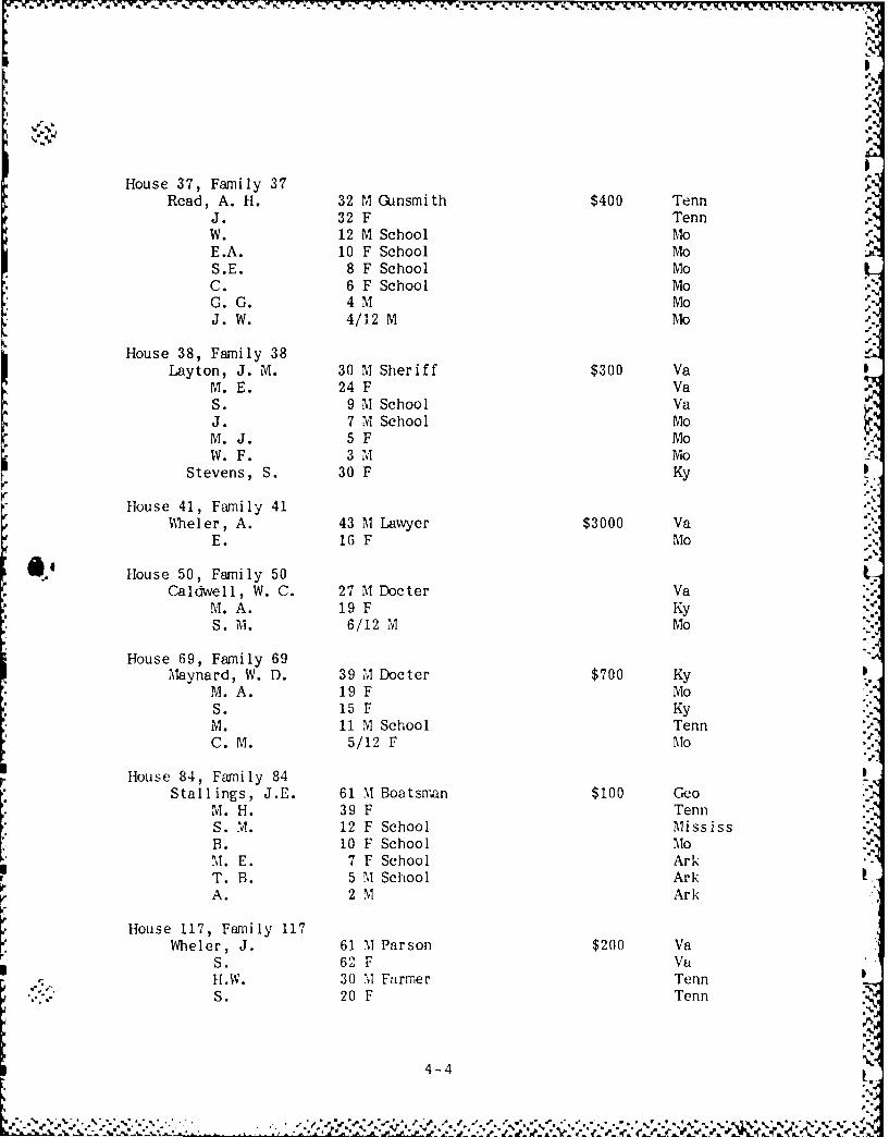
House 37, Family 37Read, A. H. 32 M Gunsmith $400 Tenn
J. 32 F TennW. 12 M School MoE.A. 10 F School MoS.E. 8 F School MoC. 6 F School MoG.G. 4 M MoJ. W. 4/12 M Mo
House 38, Family 38Layton, J. M. 30 M Sheriff $300 Va
M.E. 24 F VaS. 9 M School VaJ. 7 M School MoM.J. 5 F MoW. F. 3 M Mo
Stevens, S. 30 F Ky
House 41, Family 41;%heler, A. 43 M Lawyer $3000 Va
E. 16 F Mo
House 50, Family 50Caldwell, W. C. 27 M Docter Va
M.A. 19 F KyS. M. 6/12 M Mo
House 69, Family 69Maynard, W. D. 39 M Docter $700 Ky
M.A. 19 F MoS. 15 F KyM. 11 M School TennC. M. 5/12 F Mo
House 84, Family 84Stallings, J.E. 61 M Boatsman $100 Geo
M.H. 39 F TennS. "VT. 12 F School MississB. 10 F School MoM. E. 7 F School ArkT. B. 5 M School ArkA. 2 M Ark
House 117, Family 117Wheler, J. 61 M Parson $200 Va
S. 62 F VaH.W. 30 M Farmer TennS. 20 F Tenn
4-4- ,' . ,., ;,, -,. ,, .-. .% .,-% .. .' . , . ., . .' ", 2., ",- ., ,-, -, ,- ,' . ,,. -, -. ,, . , .... , ¢ .-. -. -,., %,_ . ,, , - -. ' ,.-,& ; ,, ,-, .', ," o " , ,s

House 137, Family 137Cox, J. W. 31 M Docter Va
S. 28 F VaJ. 9 M Va
E. 7 F VaN.V. 4F VaJ.W. 3 M MoM.C. 1 F Mo
Copied by Jeffrey A. Blakelyand Brauna J. Hartzell
at theState Historical Society of MissouriHitt and Lowry StreetsColumbia, Missouri 6520123 September, 1986
' N
:B..
S
4-5.

N
p. ,"\
APPENDIX 5
1850 United States Federal Census Agricultural Schedules
Taney County Missouri
Swan Township, pp. 523-24
1. J.W. Danforth 70 acres improved land, 300 acres unimproved land, $1300farm value, $35 implements, 5 horses, 1 ass, 10 cows, 4oxen, 8 cattle, 10 sheep, 50 swine (animals valued at$310), 800 bushels corn, 100 bushels oats, 30 poundswool, 30 bushels Irish potatoes, 25 bushels sweetpotatoes, and $80 value of slaughtered animals.
2. J.D. Caldwell 15 acres improved land, 25 acres unimproved land, $500farm value, 2 horses, 1 cow, 3 oxen, 3 other cattle(animals valued at $238), 60 pounds wool, 3 bushels peasand beans, 20 bushels Irish potatoes, 30 bushels sweetpotatoes, 130 pounds butter, 200 tons hay, 400 pounds
" flax, and $40 of slaughtered animals.
3. S.J. Ayres 3 horses, 1 cow, 1 other cow (animals valued at $157), 20pounds wool, 3 bushels peas and beans, 10 bushels Irishpotatoes, 100 pounds butter, and $60 of slaughteredanimals.
4. R.S. McKiney 30 acres improved land, 50 acres unimproved land, farmvalue $400, $15 implement, 5 horses, 4 cows, 4 oxen, 10other cattle, 34 sheep, 30 swine (animals valued at$316), 300 bushels corn, 100 bushels oats, 10 bushelsIrish potatoes, 50 pounds butter, and $60 of slaughteredanimals.
5. J. Haggard 14 acres improved land, 26 acres unimproved land, farmvalue $300, $10 implements, 2 horses, 3 cows, 6 othercattle, 24 sheep, 37 swine (animals valued at $200), 400bushels corn, 18 pounds wool, 5 bushels peas and beans,14 bushels Irish potatoes, 30 bushels sweet potatoes, 30pounds butter, and $60 of slaughtered animals.
6. W.C. Berry 1 horse, 5 cows, 2 other cattle (animals valued at $107),
30 pounds butter, and $60 of slaughtered animals.
7. A.S. Layton 20 horses, 5 cows, 15 cattle, 20 swine (animals valued at.. $1710), 240 bushels oats, 30 pounds butter, and $25 of
slaughtered animals.
%5-1
npp

8. I.P. Wood 25 acres improved land, 15 acres unimproved land, farmvalue $1500, $10 implenents, 2 horses, 1 ass, 3 cows, 5other cattle, 9 sheep, 20 swine (animals valued at $173),15 bushels wheat, 400 bushels corn, 120 bushels oats, 30pounds butter, and $15 of slaughtered animals.
9. H. Ratcliffe 18 acres improved land, 22 acres unimproved land, farmvalue $600, $15 implements, 1 horse, 3 asses, 4 cows, 15other cattle, 25 swine (animals valued at $279), 300bushels corn, 400 bushels oats, 20 pounds wool, 3 bushelspeas and beans, 15 bushels Irish potatoes, 10 poundssweet potatoes, 30 pounds butter, 100 pounds maple sugar,and $36 slaughtered animals.
10. E.W. Milliken 15 acres improved land, 25 acres unimproved land, farmvalue $450, $11 implements, 1 horse, 2 cows, 2 oxen, 2other cattle, 15 swine (animals valued at $150), 400bushels corn, 100 bushels oats, 15 pounds wool, 15bushels Irish potatoes, 40 pounds butter, 73 pounds maplesugar, and $40 of slaughtered animals.
Copied by Jeffrey A. Blakelyand Brauna J. Hartzell
at theState Historical Society of MissouriHitt and Lowry StreetsColumbia, Missouri 6520123 September, 1986
5-2YNO!

. '?
APP MD1X 6
1860 United States Federal Census
Swan Township, Taney County, Missouri
Town of Forsyth, pp. 871-73
12-13 July, 1860'
House 93, Family 95Berry, William, Sr. 39 M Clerk of Court $2500 $1750 Va
Eliza 41 F VaEllen 13 F attended school MoEveline 8 F attended school MoWilliam, Jr. 4 M MoMartha 1 F Mo
House 94, Family 96Dunlap, Robert 40 M Farmer $100 Tenn
Lavina 35 F ArkEdward 18 M ArkMary 15 F ArkEliza 13 F ArkHenry 10 M ArkJohn 9 M ArkGeorge 4 M Mo
Bagley, Lucretia 14 F Ark
House 95, Family 97
Majors, Elijah 34 M Merchant $2300 $8520 MoLucinda 36 F can not read or write KyMary 12 F school MoSusan 10 F school MoEliza 8 F school MoBenjamin 6 M MoRebecca 4 F Mo
McClure, Columbus 34 M Clerk in Store ---- $800 N C
House 96, Family 98
Grider, Jacob 45 M Blacksmith $30 $200 KyNancey 38 F KyHenry 14 M school MoWi l1 iam 12 M school MoDella 10 F school MoMary 7 F school ArkPhebe 4 F school IVoJacob 2/12 M Mo
6-i
,%1

House 96, Family 98 continuedChenoweth, William 26 NM M.D. --- $60 Oh
House 97, Family 99Boswell, Levi 19 M Painter --- $50 MO
Lucretia 23 F TenMary 1 F Mo
House 98, Family 100Hogan, John 26 M Grocer $400 Ten
Luisa 20 F I nd
House 99
House 100, Family 101Hagar, Samuel 36 M Merchant $4000 Md
Adaline 28 F KyAllis 12 F school KyCharles 8 M school Mo
Nora 4 F MOMolly 2 F Mo0
House 102 Grocery
House 103, Family 102Nave, Jacob 45 M Druggist $200 $795 Ten
can not read or writeTelitha 27 F Ten
Jacob, Jr. 1 M Mo
House 104, Family 103Huddleston, James 24 M Merchant $300 $4093 Ten
Martha 25 F VaIda JF Mo
House 105 Store
House 106, Family 104Ogle, Harekus 42 M Carpenter $ 3117 Ten
Susan 28 F TenNancey 6 F school MoElizabeth 3 F MOJohn 1 M Mo
6-2 - $T-

. A
House 107, Family 105Sanders, James 40 M Grocer $1800 $350 Ky
Jane 18 F Mo
Mary 10 F Mo
Anna(?) 7 F school Mo
James 7/12 M Mo
p.. Curtis, Lucasy 11 F N C
House 108, Family 106Farmer, Mary 38 F Va
Leopold 19 M MoWillis 13 M Mo
Alfred 7 M Mo
Robert 1 M Mo
House 109, Family 107 StoreIA Anderson, Thomas 24 M Merchant $1750 $1500 Ky
House 110, Family 108 Hotel
Thompson, Allocious 37 M Farmer $1500 $1346 Ten
nily 21 F Ten
Moss, John 23 M Clerk in Store Tena-House 111, Family 109
McKinny, Benjamin 21 M Tanner $4370 Ten(married within the year)
John 10 M school Mo
Sarah 6 F school Mo
House 112, Family 110Vance, John 40 M Retired Merchant $3612 $740 Ten
House 113, Family 111Wilson, William 37 M M.D. $500 $1604 Ky
Martha 23 (or 29) F Ky
Joseph 10 M school Ky
Alice 7 F school Mo
Earnest 3 M Mo
House 114, Family 112
Eslake, Arlus 46 M Farmer ---- $207 Ky(married within the year)
Lela 45 F Ten(married within the year)
Lav ina 23 F I nd
David 19 " 'I Farm hand Mo
Susan 16 F Mo
John 14 IM Mo
-. .. Beeden 12 F Mo
6-3
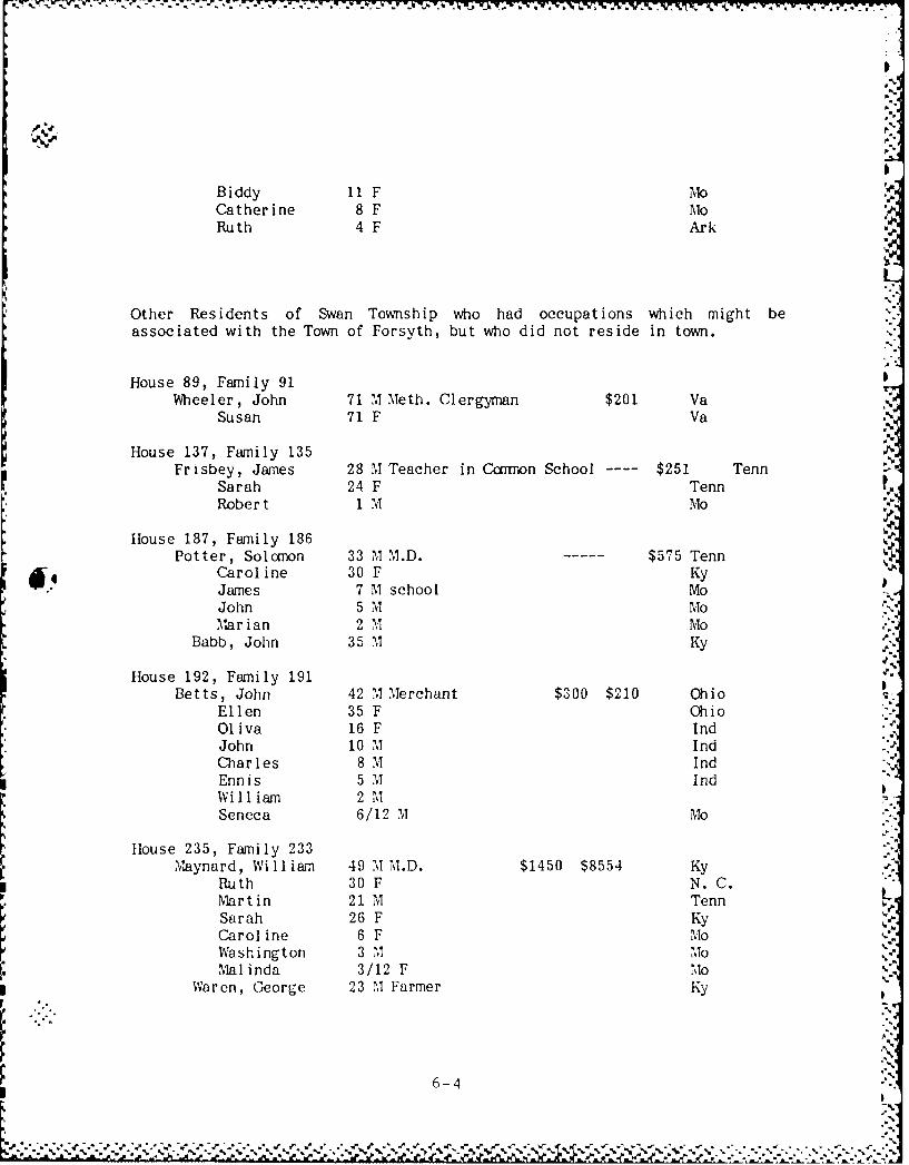
* ** -. . . L .
' '- .**..- . *- **4'.\ . M-*,_ , . . j -- S. . , . S - -_ _
%p
Biddy 11 F N1oCatherine 8 F MioRuth 4 F Ark
Other Residents of Swan Township who had occupations which might beassociated with the Town of Forsyth, but who did not reside in town.
House 89, Family 91Wh'veeler, John 71 M Meth. Clergyman $201 Va
Susan 71 F Va
House 137, Family 135 MFrisbey, James 2 8 M Teacher in Ccimon School ---- $251 Tenn .M
Sarah 24 F TennRobert 1 M Mo
House 187, Family 186Potter, Solomnon 33 74 M.D. --- $575 Tenn
Caroline 30 F KyJames 7 M school MoJohn 5 M MoMar i an 2 M Mo0
Babb, John 35 M Ky
House 192, Family 191Betts, John 42 M.Merchant $300 $210 Ohio
Ellen 35 F OhioOliva 16 F IndJohn 10 M IndCharles 8 M\ I ndEnnis 5 N1 IndWill1iam 2 M
Seneca 6/12 M Mo[House 235, Family 233Maynard, William 49 M M.D. $1450 $8554 Ky
Ruth 30 F N. C.Martin 21 M Tenn I
Sarah 26 F KyCaroline 6 F Mo .
Washington 3 "1 Mo1Mal inda 3/12 F Mo
Waren, George 23 M Farmer Ky
rt
6-4
Im
.5

U'i
House 247, Family 245Adams, Charles 55 M Clergyman, Christian Order $2000 $1970 Tenn
(married within the year)Martha 24 F Mo
(married within the year)
Missouri 3 F Mo* Ruisa 1 F Mo
p.
Copied by Jeffrey A. Blakely
and Brauna J. Hartzellat theState Historical Society of MissouriHitt and Lowry Streets
Columbia, Missouri 6520123 September, 1986
0
6-5

APPMDIX 7
1860 United States Federal Census Agricultural Schedules
Taney County Missouri
Forsyth, Swan Township
1. William Berry 4 horses, 8 milk cows, 8 oxen, 7 cattle, 22 swine(animals valued at $1038), 200 pounds butter, value ofslaughtered animals $75.
2. Robert Dunlap 10 pounds butter, value of slaughtered animals $50.
3. Elijah Majors 60 acres improved land, 180 acres unimproved land, farmvalue $2300, $125 implements, 5 horses, 14 asses ormules, 10 milk cows, 20 oxen, 20 other cattle, 10 swine(animals valued at $3093), 75 bushels wheat, 30 bushelssweet potatoes, 100 pounds butter, 3 tons hay.
4. Jacob Grider
5. Levi Boswell
6. William Chenoweth 1 horse, 60 bushels wheat.
7. Samuel Hagar I cow, 15 bushels wheat.
8. Jacob Nare 2 horses, I milk cow, 1 other cow, 11 swine, 295 bushelswheat.
9.James Huddleston 40 acres unimproved land valued at $200, 8 horses, 1 assor mule, 4 milk cows, 3 oxen, 3 other cattle, 16 swine,693 bushels wheat.
10. Iarcklus Ogle 1 milk cow, 1 other cow, 17 bushels wheat.
11. James Sanders 1 milk cow, 12 swine, 28 bushels wheat.
12. Alloicious Thompson 24 acres improved land, 12 acres unimproved land,farm value $1300, $146 irrolements, 100 bushels Wheat.
13. Benjamin MTcKinney $150 implenents, 4 horses, 1 milk cow, 6 oxen, 3other cattle, 632 bushels wheat, 45 bushels rye, 200bushels corn, 20 bushels Irish potatoes, 8 tons hay,value of slaughtered animals $28.
s.,
7-1'F"2 .. € " Z'J "", -, €"2 " .2 " "" -":" ", "" " . . :"."""-"," . . ".% ."- .-,...,.

J
14. John Vance 2 horses, 20 milk cows, 30 other cattle (animals valued$20), 620 bushels wheat, value of slaughtered animials
$175.
15. William Wilson 1 horse, 9 milk cows, 16 other cattle, 309 bushels wheat.
16. Orthro Eslake $3 implenents, 1 horse, 1 milk cow, 2 oxen (animalsvalued at $16), 174 bushels wheat, 30 bushels corn, 2000pounds tobacco.
Copied by Jeffrey A. Blakelyand Brauna J. Hartzell
at theState Historical Society of MissouriHitt and Lowry StreetsColumbia, Missouri 6520123 September, 1986
7-2
I,
, -. -. -, -. , . ..- . .-. .- . ..- -,, . - - - , - -._. -.. -, % , ; .
APPENDIX 8
The Dubuque HeraldSaturday morning, July 27, 1861, Page 2
Army Correspondence -- No. 28
Springfield, Mo., July 19,1861
. ...... Saturday. -- This morning an expedition has been ordered againstsone point south of this, and for the purpose 2000 men have been detailed,who, as I write, are filing past the "Bailey House". Among the 2000 are theGovernor Greys, F. J. Herron; Iowa City Canpany, Lieut. Graham, ccomanding;Davenport Guards, Capt. Mentz; Burlington Zonaves, Lieut. Abercranrbie,carmanding, Jackson Guards, Capt. Gotteshall; Mt. Pleasant Greys, Capt. Wise-- in all 500 -- all of whom will be recognized as Iowa Companies. We aregoing southward some distance -- how far I know not, and I am thus equallyin the dark as to the purpose of the mission -- however it probably hassomething to do with breaking up a Secessionist camp reported to be in thatdirection. We have also along 200 Regular Cavalry, and Captain Totten'sBattery of four pieces. If we don't have a fight, we shall at least havethe excitement of a march and the exploration of new scenes, and thepossible acquaintance of the rankest secessionists in Missouri.
The news of Captain Matthies, of Burlington being appointed LieutenantColonel, was received at once with pleasure and regret -- pleasure that thechoice had fallen upon so fine a soldier and so perfect a gentleman, andregret that the 1st Iowa Regiment will be deprived of the services of anofficer so able and popular. He leaves to-morrow for Burlington and willcarry an order for the irmediate appearance at this point of the 5th and 6thIowa Regiments, if they are ready for action. From this it will be seen, aswell as from the past, that Iowa is doing her share towards subduingsecession in Missouri.
Several copanies, including Capt. Conrad's, left for St. Louis to-day,acccmpanied by a long train of wagons. The latter are designed to returnwith supplies.
But I must get upon my mule, and as for the present Au RevoirWILKIE
Copied by Brauna J. Hartzellfrom a XEROX copy made at
State Historical Society of WisconsinMadison, Wisconsin 53706
15 October, 1986
.,
8-1
F r
_ ~- .~ K

APPENDIX 9
The New York TimesTuesday, July 30, 1861, Page 1
THE WAR IN MISSCJ.RI
Rebels Dispersed at Forsythe
Forsythe, Mo., Sunday, July 28.
Gen. SE'=xS cc-rnand, which left Springfield on Saturday last, arrivedhere to-day and dispersed a band of one hundred and fifty rebels stationedhere, and took possession of the town. Five of the rebels were killed andseveral wounded. Three of our men were slightly wounded, but none killed.The first and second stories of the Court-house here were filled withblankets, provisions, camp equipage, etc., which, together with two tons oflead found in a well and other articles secreted in different parts of thetown, in all valued between eighteen and twenty thousand dollars, fell intoour hands. MIt. WILEY, correspondent of the NEW YQRK TIMES, was slightlywounded.
K'.
Copied by Jeffrey A. Blakelyat the Library of .Ouachita Baptist UniversityArkadelphia, Arkansas 7192311 Septeaber, 1986
9,1a a,%
S.'
,.
a-a'4
* 2..5.
jm a
-: 9-1
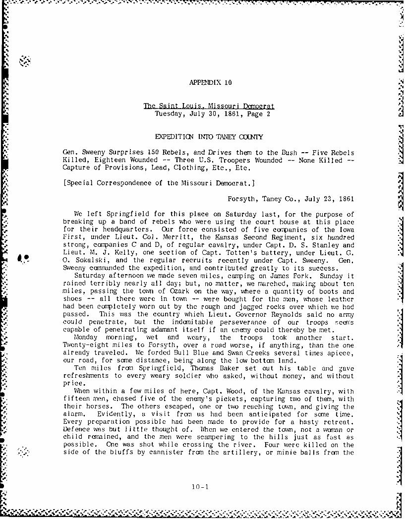
APPENDIX 10
The Saint Louis, Missouri Democrat
Tuesday, July 30, 1861, Page 2
EXPEDITICN INTO TA -EY C-IY
Gen. Sweeny Surprises 150 Rebels, and Drives then to the Bush -- Five RebelsKilled, Eighteen Wounded -- Three U.S. Troopers Wounded -- None Killed --Capture of Provisions, Lead, Clothing, Etc., Etc.
[Special Correspondence of the Missouri Demoerat.]
Forsyth, Taney Co., July 23, 1861
We left Springfield for this place on Saturday last, for the purpose of
breaking up a band of rebels who were using the court house at this placefor their headquarters. Our force consisted of five companies of the IowaFirst, under Lieut. Col. Merritt, the Kansas Second Regiment, six hundredstrong, capanies C and D, of regular cavalry, under Capt. D. S. Stanley andLieut. M. J. Kelly, one section of Capt. Totten's battery, under Lieut. G.0. Sokalski, and the regular recruits recently under Capt. Sweeny. Gen.
Sweeny ccm-anded the expedition, and contributed greatly to its success.Saturday afternoon we made seven miles, camping on James Fork. Sunday it
rained terribly nearly all day; but, no matter, we marched, making about tenmiles, passing the town of Ozark on the way, where a quantity of boots andshoes -- all there were in town -- were bought for the men, whose leatherhad been completely worn out by the rough and jagged rocks over which we hadpassed. Thnis was the country which Lieut. Governor Reynolds said no armycould penetrate, but the indomitable perseverance of our troops seenscapable of penetrating adamant itself if an enemy could thereby be met.
Monday morning, wet and weary, the troops took another start.Tventy-eight miles to Forsyth, over a road worse, if anything, than the onealready traveled. We forded Bull Blue and Swan Creeks several times apiece,our road, for sane distance, being along the low botton land.
Ten miles fron Springfield, Thomas Baker set out his table and gaverefreshments to every weary soldier who asked, without money, and withoutprice.
When within a few miles of here, Capt. Wood, of the Kansas cavalry, withfifteen men, chased five of the enany's pickets, capturing two of them, withtheir horses. The others escaped, one or two reaching town, and giving thealarm. Evidently, a visit from us had been anticipated for some time.Every preparation possible had been made to provide for a hasty retreat.Defence was but little thought of. When we entered the town, not a woman orchild remained, and the men were scampering to the hills just as fast aspossible. One was shot while crossing the river. Four were killed on theside of the bluffs by cannister frn the artillery, or minie bails from the
10-1
-aN.

muskets of the Iowa and Kansas volunteers. Captain Stanley, who was the" first to enter town, had a fine horse shot fron under him and killed. Two
other horses were wounded on our side. Seven, in all, were captured fromthe enemy. Two tons of lead have been found this morning in a well near theCourt House. The first and second stories of the Court House containedblankets, provisions, clothing, camp equipage, &c., which, together withthat found elsewhere in town secreted, would amount to $18,000 or $20,000.
Three of our men were slightly wounded. Their names were Martin, Caseyand Wilthorne -- all of the regular cavalry. Lieutenant Kelly, with CompanyC, pursued the eneny up the hill, northeast of the town, driving them overthe bluff, where the artillery reached them with cannister.
The infantry marched the last two miles on the run, all [anxious ?] toparticipate in the firing which the cavalry had opened with the enemy. Thelatter were ccrnanded by John Price and Maj. Franklin. Captain Jackson, arelative of Ellsworth's murderer, was among the killed. He fell piercedwith seven balls. Captain Wyatt was in camand of one of their companies.Valuable correspondence was secured, giving information of the plans of theenemy.
To-day we shall start on our return to Springfield and march about tenmiles, camping near our friend Baker's, who treated us so generouslyyesterday. He will lose nothing by his liberality.
- I cannot close without mentioning Major Mills as forward in pursuit ofthe enemy, at whom he got several shots, and Mr Spencer, who has renderedthe reporters every accommodation.
By the misunderstanding of an order one solid shot and two spherical case12-pounder shells, were fired into the court house, and Mr. Wilkey,correspondent for the Dubuque Herald and New York Times, knocked over andslightly wounded.
B.
Copied by Brauna J. Hartzellat the
State Historical Society of Missouri
Hitt and Lowry StreetsColumbia, Missouri 6520123 September, 1986
10-2

APPENDIX 11
The New York HeraldWednesday, July 31, 1861
Vol. 26, No. 210, Page 1 and 8
Occupation of Forsythe. MissouriOur Forsythe Correspondence
The March fron Springfield to Forsythe - The Rebels Baffled - Union CavalrySurprise the Town - Successful Charge of Infantry Up the Hill - The RebelsRun - Occupation of Forsythe.
Ftrsythe, Taney Co., Mo., July 23, 1861
On Saturday morning last Brigadier General Sweeny, cmTranding inSouthwestern Missouri, received orders from Major General Lyon to proceedwith a proper force to Forsythe, a small town on the White River, and withintwelve miles of the Arkansas line. It had been ascertained that a rebelforce of from eight hundred to one thousand men had gathered at that pointand were daily expecting reinforcements from Arkansas and Tennessee,Forsythe being at the head of navigation of White river, and accessible bysteamboat from the Mississippi at the present stage of water. GeneralSweeny, on receiving orders, at once made selection of Companies C and D ofFirst cavalry, under corrmnand of Captain B. S. Stanley; one section ofCaptain Totten's battery, under Lieutenant Sokalski; one company of Kansasmounted men, Captain Wood; five hundred men of the Iowa First regiment, Col.Merritt, and five hundred of the Kansas Second, Colonel Mitchell. A squad ofeighty Home Guards accompanied this expedition, joining it sane ten milesfram its starting point. The whole left Springfield about noon on Saturdayand took up its line of mrch for Forsythe, fifty miles distant. Onbreaking up camp on the morning of the 22d, we were twenty-eight miles from
the place of our destination, a heavy rain, which fell on the 21st andcontinued through the day, having made our previous marches very short. Theroad, with the exception of seven miles of prairie near Springfield, passesthe entire distance among the Ozark Mountains, and is in many placesexceedingly rough. After our noon halt, twelve miles from Forsythe, GeneralSweeny sent forward the entire force of mounted men to a small hamlet withinthree miles of the town, where the enemy was said to have a mounted picketof fifty men. These advanced, and with them your correspondent, but nopicket could be found. Captain Wood, with ten men, went along the road toreconnoitre, while an orderly was sent back to General Sweeny for further
coanands. In a short time he returned, bringing orders for the cavalryforce to advance upon Forsythe, and if an enemy were found there, to holdhim in check till the artillery and infantry could come up. Captain Stanleygave the word to move forward, and we advanced at a gentle trot, meeting
"." aout two miles from town four of Captain Wood's men, with two pickets of
11-1
-I- -
the rebels, captured within a mile of Forsythe. The pace was then quickenedto a gallop until we reached a small stream called Swan Creek, which skirtsthe town on the north and west. Forsythe is situated in a romantic glenupwards of a mile in length and about three fourths of a mile in width. Onthe south side flows White river. Swan Creek strikes the town lines at thenortheast corner, and after flowing along the northern and westernboundaries, falls into the first-mentioned stream. On all sides bluffs,from one to four hundred feet in height push themselves abruptly from theedge of the town site, some of them precipitous and others with a regularbut steep ascent to the sunmit. The road from Springfield enters on thenorthern side of the town, crossing Swan Creek and winding for some twentyrods directly under the edge of a high cliff and opening into Forsythe inthe rear of the Court House. It was supposed -- correctly as the sequelproved -- that the rebels had posted men along the cliff who would be ablegreatly to trouble our troops passing beneath, and be themselves but littleexposed. Accordingly Captain Stanley turned from the road before reachingthe cliff, and passed through a small copse of oaks, entering a corn field,where the corn, some twelve feet in height, completely screened his men fromview. Our distance from the cliff was sone thirty rods, too far for theguns of the rebels to have any effect provided we had been in sight.Passing through this cornfield it was necessary to recross the creek. Atthe ford the bank which we descended was so steep that our horses did notattempt to walk to reach the waters edge, but planted their feet firmly in
4. position and slid down upon the moist clayey soil, with all the grace of aschoolboy enjoying his winter holiday on his favorite coasting track. Onthe opposite side was a level ground plat of sufficient width to form thecavalry in line. This was the work of the moment. The advance was sounded,and the whole column of regular cavalry made a dash into town at fullgallop, entering by the Springfield road, while Captain Wood, with his
Kansas rangers swept around to the right and joined Captain Stanley near theCourt House. The village was canpletely deserted, all the inhabitants,anticipating trouble, having moved away some days since. Fire was openedupon us from the bluff, on the northeast and from the south bank of Whiteriver, the stream being about a hundred yards in width. The most rapidfiring was from across the river, and the cavalry made for the northernshore, dismounting and advancing on foot. A row of bushes skirting eitherbank concealed both bodies of combatants, but the firing was rapid, andseveral of the enemy were seen to fall. In about ten minutes orders weregiven to cease, as the rebel fire had been silenced.
The firing from the bluff on the northeast was still kept up, and CaptainStanley, leaving Captain Wood's Kansas men in possession of the town,ordered a charge up the hill, a rocky acclivity quite difficult of ascent,and sane three hundred feet high. About half way from base to surnitcannences a grove of scrub oaks which crest the hill and cover the bluffs tothe rear. In this grove and beyond, by the side of the road, the encny wereposted, but a brisk fire from our men, who again advanced on foot, speedilydislodged them. At the same time the artillery, which had cane up and taken
* position to the right of the before mentioned cornfield, opened fire uponthose posted near the road. Not relishing Lieutenant Sokalski's grape and
". 11-2
-.

.. .. . . _ -..tt
canister, the roadside rebels beat a retreat, and soon were seen flying --
Over the hills and far awayTwo shells were then thrown into the court house, under the belief that
the enemy were there in position. The infantry advanced into town inregular line of battle, but found only their own friends. About this timethe last of the rebels were seen on the opposite shore of White river,making good time towards the timber.
At the time our firing by the river took place the main column was nearlytwo miles away. Hearing the reports of the carbines General Sweeney orderedthe artillery to a run, intending to cane up at the usual pace with theinfantry. The latter had been marching all day over a bad road, and many ofthe men were footsore; but on listening to the firing every man forgot hisblisters and lameness, and with a loud cheer the ranks instantly closed up,and the whole column advanced at the double quick, keeping equal pace withthe artillery. After arms were stacked in the public square not a manappeared to be weary in the least degree. All seemed as fresh as at thecarmencement of the march.
On the side of the Union forces privates Martin, Wilthorne and Corsey, ofCanpany D, First cavalry, were wounded -- none fatally. Two horses werekilled and one wounded. Captain Stanley's horse was shot under him at thetime of the firing by the river.
The rebels are reported to have five killed and thirteen wounded; amongthe former, Capt. Jackson, carander of the rebel company. Seven of their
.0 horses v% re captured. They had 150 men in action.At the time the shells were fired into the court house several of our men
were inside the building. None were injured, with the exception of F. B.Wilkie, correspondent of the Dubuque H , who was hit on the head by apiece of brick, the sharp edge just breaking the skin. The party made aspeedy exit from the hall.
Gen. Sweeney has displayed much tact and ability of management of theexpedition thus far. He has been ably assisted by his principal staffofficer, Maj. James K. Mills. The march has been into a rough and partiallysettled region, where the rebel leaders have prophesied that an army couldnot be sent. A considerable amount of provisions and amnunition was taken.Twenty-seven guns were seized in the court house. Two tons of lead werethrown into a well by the rebels, but it was speedily brought to light.
We move to-day back to Springfield.EVENING, 23D, 12 MILES FtM- r-USIE
About two miles this side of town an ambushed party of rebels fired uponour men, but at too great a distance to have any effect. A shell and acanister shot from our six pounder scattered the rebels. Like the bad boyin the play, they have not been heard of since.
Copied by Brauna J. Hartzellfrom a X]I.X copy made at
State Historical Society of WisconsinMadison, Wisconsin 53706
1 Noven-ber, 1986p"
I.11-3
" ""'" " " " '" " " "" ".' . " - -" ' "-" "' ''% "-- ". -" . . . ." " ". .'."" " " . . . .. ." ." • " . " . . ' '

- .-. w - r'rrr r rr .. ''-'-r
APPENDIX 12
The Newv York Times
Wednesday, July 31, 1861, Page 8
ThE WAR IN MISSCLRI
Our Springfield Correspondence
Gen. Sweeney's Dispersion of the Rebels at Forsythe -- Another Foot-Race --
Property Found in the Court-House
Springfield, Mo., Wednesday, July 24, 1861.
Last Saturday, 1,200 men were detailed under Gen. SWEENEY, to break up asecession camp, located at Forsythe -- a point about fifty miles south ofthis, and situated at or near the foot of the Ozark Mountains. Monday atstarting, we were thirty miles from Forsythe, having only made twenty milesin the two days previous, owing to heavy rains and the consequent almostimpassable character of the mountain roads. However, the day was cool, andthe men pushed forward with a vigor that brought them to their destinationat 2 P.M. of the same day.
Our canand was cornposed of Ccranies C and D, Dragoons, under Capt.STANLEY, a section of Capt. TOT=2'S Battery, under charge of Lieut.Sa{:ALSKI, five hundred of the First Iowa Regiment, under Lieut.-Col.MERITT, and a balance made up of mounted Kansas Volunteers, under Capt.WXID, and Second Kansas Infantry, under Col. MITCIELL.
Forsythe has been noted for sine time as being the rendezvous of sanefour hundred Secessionists, who drilled there, and made it the basis of aseries of predatory operations upon the property of Union men living in thevicinity. They were said to be fortified in the Court-house, and, by thecharacter of the town, to an extent that would enable the. to resist a muchsuperior force. This fact or report, together with the one that they hadplenty of arms, provisions, &c., determined Gen. LY(N to break them up.
About three miles this side, ten men went forward to rake areconnoissance. A mile or so ahead they ran against one of the enemy'spickets -- one of whom they captured, but the other two escaped, andprobably gave the alarm in the town. Conpanies C and D, under Capt.STANLEY, and the Kansas M1,ounted Volunteers, under Capt. 1 kOD, were orderedto charge irmediately on the town, while the rest were directed to follow up
" in double-quick.r The town is situated at the confluence of Swan Creek and White River,
which protect it on its northwest and southwest sides, while to the east itis guarded by an almost inaccessible bluff, heavily timbered. The approachof the troops was from the north side -- the Dragoons were to attackindirectly in front, the Kansas men to proceed to their rig-ht, and whilesome mounted Hone Guards were detailed to the right of these, the Artillery
J 12-1.1 -I
.% . ... .'. . % .,. '.V, %-1,. -,- .. -. ., .. ~ % .. ,,, .. * %, -, K..A-, - . . ,.. .- . . . . . ,],-

was to take position a half mile or so from town on an eminence, supportedon either side by the infantry. These dispositions made, the order"Forward" was given, and for the three miles the cavalry proceeded on a 4tremendous gallop, forded Swan Creek, and then taking intervals, dashedstraight on the town. We were a little too late, but just in time to seeabout 150 Secessionists break fron all parts of the town, ford White Riverand gain the woods beyond, or rush up the steep bluffs, where theydisappeared in the timber. The party that forded White River took positionamong the trees and opened a sharp fire on the United States troops, but ahundred shots or so fram the Sharpe's rifles of the Dragoons sent thenflying towards the Arkansas border. Scarcely had they left, when the partyvhich sought the shelter of the bluffs opened fire upon us, but Capt.STANLEY and Lieut. M. J. KELLEY, of Company C, dashed off with some fiftyDragoons, when they fled and were seen no more.
About this time the Artillery came up and opened on the Court-house,which at the time was occupied by several of our own men, including thereporter of the Dubuque Times. Three shells were fired into it before themistake was discovered. Fortunately, no one but the reporter was injured,and he only slightly by being struck by a splinter in the back of the head.The artillery then turned its attention to the bluffs, and sent threecharges of grape into a party of Secessionists, who were evidently takingFrench leave of the section. They scattered all but three or four, whoremained -- and probably will remain there till removed by their friends.in In the Court-house were found blankets, rifles, provisions and clothingin large quantities. A large quantity of lead was recovered from a wellinto which it had been thrown, and, in addition, several horses and one ortwo prisoners were captured.
Our loss was slight. Privates WILIUNE and =ARVIN, Conpany D, Dragoons,were wounded slightly, and another man had a ball sent through his shoulder,and Capt. ST~ANLEY'S horse was shot under him, and two other horses wereslightly wounded. The Secessionists lost five killed and ten wounded --
among them was said to be Capt. JACKSCIq.The corrmand camped in the town Monday night, and Tuesday at noon
cormenced their march homewards, and will probably reach here by noonto-i .or row.
At Yellville, on the Arkansas border, there is said to be 1,000Secessionists, and at Camp Walken, in the northwestern part of the State,i0,000, whose design is to retake Springfield, and fran here march on St.Lou is.
GALWAY.
Copied by Jeffrey A. Blakelyat the Library ofOuachita Baptist CollegeArkadelphia, Arkansas 7192311 September, 1986
12-2
- .* - -.- . - - -

APPENDIX 13
The.Dubuque HeraldThursday morning, August 1, 1861, Page 2
Army Correspondence --- No. 28.
Springfield, Mo., July 24, 1861
In my last, dated last Saturday, I spoke of an expedition southwards, andas I have just returned, I can give you full particulars. The ccrrnand wasunder General Sweeney, and was composed of 1200 men -- 500 of whm were theist Iowa Regiment under Lieutenant Colonel Merritt, Capanies C and D U.S.Dragoons, Captain Stanley and Lieut. M. J. Kelly, one company of mountedvolunteers fron Kansas under Captain Wood, some of Captain Totten's Batteryunder Lieut. Sokalski. We had ten days' rations and left with a view tobreak up a secession camp at Forsyth, 56 miles south of here on the southside of the Ozark M,1ountains.
We left here about noon, and as the day was intensely hot, and many ofthe men had marched 11 miles before reaching Springfield the soldiers gaveout by scores, -- several among whom was Lieut. Marvin of Canpany D hadsunstrokes -- the dust was suffocating, and after rmarching seven miles, wecamped on both sides of James Fork of White River. That night it rained asif the Indian Ocean had been upset on us -- the thunder roared through themountain tops, as if ten thousand devils were howling from each peak, whilethe whole sky seemed for hours one incessant blaze of white ghastly flame.I generally enjoy quiet "family" thunder showers, but this was considerablytoo much of what generally may be considered a good thing, especially in thecountry. A hard shell Baptist Church saved a majority of the men forprotection -- a hundred or so got in the covered bridge of the River, and asquad of reporters, enjoyed the hospitalities of the roof and fireside of anardent secessionists in the vicinity who rejoiced in the euphonic
designation of Abner Dabbs.The next morning -- Sunday -- it still rained only a good deal harder, as
if the Atlantic had been emptied into our Indian Ocean shower. We madefifteen miles that day, and hal ted, when for the first time since the nightbefore the rain "let up". That night I staid with an old fellow of 53 namedJames Varnyn, who owns a fine farm, and "heaps" of niggers right in themountains. He had 12 children by his first wife, and now has another wife .of 22 -- who lately rejoiced the frosty headed sire by presenting him with acouple of "tip top" first-class babies. The much boasted of feat, of Sarah,isn't so much ahead after all.
Fram this point to Forsyth it is 30 miles, along which on Monday our menpushed on with alacrity. The road lay down the mountains -- now, windingalong a stupendous edge, now skirting a ravine of dizzy depths, running upalmost perpendicular ascents for miles, or crossing mountain torrents, or Iran between vast heights along the rocky channels of the dried-up streams.
13-1

At 2 P. M. we had reached a point four miles from Forsyth where the cavalryhalted to allow the infantry and artillery to come up. I rode half a mileand stopped at the house of an old woman, who asked which side I was on. Itold her Price's (Price was the leader or one of them of the secessionforces at Forsyth) when she said it was all right, and a few minutes aftersaid that three men on foot, just before passed on a run towards Forsyth. Icorn'llnicated this to Capt. Wood, who just then came up, and he instantly
sent ten mounted men ahead to catch the fellows if possible. Not doubting
they would give the alarm, Gen. Sweeny ordered the column to advance.Cocpanies C and D of dragoons under Capt. Stanley took the lead, or rather
followed the reporters of the New York Herald, Dubuque Herald, and the St.Louis Ieocrat, who spurred on in advance. After the dragoons came themounted volunteers, then the artillery and infantry.
We started on a walk, and a half mile ahead, met two of the ten mencoming back at the top of their horses speed. One of them led a horse uponwhich was strapped a young Missourian, while close behind came the other
with a cocked revolver in one hand. They halted a moment -- this fellow wasone of the three advanced pickets of the enemy -- the other two had escapedand probably were in town ere this. The word was passed back to Gen.Sweeney and in about five minutes came the orders to advance. The road wasdown a steep ridge that terminated only at the town. Away we went -- firsta trot then a gallop, till the hills shook with the thundering tread of the
{O squadron of five hundred horsemen, dashing in column down the rocky descent.
-- The stones and gravel flew, and so did we, and in next to no time, werounded a bend in the road that brought us a full sight of the town.
Thinking the Regulars might be aggrieved if the reporters kept ahead, Isuggested to my quill-driving corrades that we should fall in behind them --
give them the first chance at the glory -- and the bullets. This wasconsented to, Company C and D went ahead, Capt. Wood advanced to the rightof the Regulars, and then straight through a piece of timber, down through acornfield, ive charged at them. Swan Creek ran between us and the town, and
a long time was spent in getting over, as the banks were thirty feet downand steep, and the water breast high. However companies C and D got across Ifirst, and formed on the other side, each man cocked his Sharpe's rifle andrevolver, and then with a tremendous cheer the men dug their spurs into
tleir horses, and broke through the town.From Swan Creek the land rises gently for three hundred yards to the
centre of the village, and then slopes away gradually for a like distance toWhite River, which runs along the south side of the place. As the squadronreached this ridge, they caught sight of the coat tails of 150 of thecavalry as they disappeared in a woods lying some two hundred yards from the
further bank of the river. The squadron galloped on towards the bank -- Ifollowed some six yards behind, congratulating myself as I saw the chivalry
"putting" for the timber that a battle was'nt so dangerous after all. Justthen tw went a bullet straight from the direction I was going andclose by my head, and the next instant it was tw-r-r-rvr tw-r-r-r-r
Stw-r-r-rr, as if the whole air had suddenly become alive with invinciblesnakes or reptiles with peculiar hissing propensities. I drove in thespurs, and put a substantial log house between myself and the bullets,
UI 13-2
%" '

satisfied to lose the beauty of the same providing I could avoid thenecessity of meeting some of the leaden devils that were diving through theair, as if vicious in their tendencies.
Off went the Dragoons frn the horses, and as the Infantry advanced up tothe bank and corrmenced a rapid fire upon the enemy, who secured somewhat bythe trees were letting drive at us vigorously from the other side.Seventy-five or a hundred shots seemed sufficient for them, and they quitfiring. I was standing on the north side of the log house -- the enemy wason the south side of the river, to the east was a tremendous bluff. I wasjust congratulating myself upon my taste in selecting a house apparently sobullet-proof, when, whiz came a shower of bullets fram the bluff. Here wasa pretty fix! If I went round the house to get out of this fire I should beexposed to the other, and there was no particular choice as to being shot atthe gable end or in front of the house that stood near -- a dilenma withneither more preferable. Down went Capt. Stanley's horse shot through thelungs, another went tearing around with a bullet in its a leg, a third eatup some wildcapers as a ball ploughed through its nose. And the men, too,seemed uncanfortable -- one fellow did some tall swearing over a bullet holethat appeared "clean" through the calf of his leg, another making wry facesover a similar orifice that suddenly went through his shoulders -- a thirdunbuttoned his coat to find a half inch furrow ploughed straight across hischest. And I -- well I expected it in the leg, head, back, arms, chest,somewhere every second, and -- I confess -- just wished myself out of town,4,say a couple of miles. For about two minutes the bullets came spatteringinto the fences and tearing up the ground when Capt. Stanley gave the wordcharge. The bugle rang out a few shrill notes, and the next instant Capt.Stanley, at the head of Co. D, and Lieut. Kelly leading Co. C, breasted thebluff, and rolled up it like a hurricane. Chivalry inmediately betookitself to its heels, and "broke" for deeper timber, which, thank Heaven, wasthe last seen of them from that direction.
The Court House -- a fine three story brick -- stood in the centre of thetown, and leading my horse into a blacksmith shop, I tied it, and walkedinto the Court House. The lower story was filled with benches and rifles,which the secessionists had abandoned in their ho: (sic) haste. Accompaniedby Capt. Callaway of the Home Guards and a Kansas Sergeant, we proceeded tothe upper floor, which was filled with clothing. The Sergeant seatedhimself at a table, the Captain and I entered into a small-talk conversation-- when -- whang! -- For a second I thought the bluff had tipped over onthe Court House -- next that the Comet had collided with mother earth, butfinally concluded that somebody had sent a shell through the Court House.Through the dim media of flying brick and mortar I perceived the Captainbolting for the door -- the Sergeant was getting himself unmixed fran the Ibricks in whose embraces he had rolled on the floor. Another second and wewere doing "tall traveling" after Captain Callaway, only pausing thebriefest part of a second to notice an im-nense opening in the wall throughwhich had broke the shell, passing between the Captain and myself, at aboutthe hight of our knees, and then tearing on, had smashed through thepartition beyond. Down stairs forty steps at a leap for all I, but not more
* '.*o than half down -- myself in the rear -- when again another tremendous whang, V
13-3
" ( " " " " " * -" "*" " " '*" '"".""". ¢ . ."" • " . '' --p .3"1. ' - ,',., '' . . " "

- .. -p- 7d *
and scmething tore through just over my head, tearing things all tosplinters, and sending me without further effort on my part to the bottarn ofthe stairway. I got up, and dizzily staggered on and reached the door just
as another shell tore through the lower story making kindling of a score ofbenches and burying itself in the south wall without exploding. I found asevere wound on the back of my head from which the blood ran in streams, andfor the moment supposed myself killed, as I felt so weak and unsteady -- a
,. mistake, however, as the writing of this letter (with a very sore headthough) same thirty-six hours after will abundantly demonstrate.
But to return. About the time I entered the Court House the Artillerycame up to a point in the road that overlooked the town, and Gen. Sweeneygave orders to have the pieces brought to .ea on the town. This wasmisunderstood by Lieut. Sokalski, who supposed it was to .fir-. on the town.Instantly he unlimbered his twelves pounder and sent three shells into theCourt House before the mistake was discovered. Just then a body ofSecessionists made their appearance on the bluffs, and ccrrmenced a fire onthe battery, which was flanked on the left by the Gov. Greys, under Capt. F.J. Herron and the Davenport Rifles, under Capt. Mentz. Lieutenant Sokalskiinnediately put his 12-pounder to a better use than firing shells at aReporter by sending three charges of grape into the enemy, all of wharn butfour or five left instanter and have not since been visible. The four orfive that staid, stay there yet if their friends have not carried then away.
I. And thus ended the "battle" of Forsyth -- or a "skirmish", or "affair",S -as the case may be. The Greys and Davenport Rifles were under fire for a
." few minutes, and stood the initiation with perfect ccposure. The men wereall anxious for a fight, for when the word was passed back to the Infantryto hurry up, they struck into double-quick and ran a distance of over three
miles, notwithstanding that they had already traveled twenty-seven long andtedious miles the same day. Two men, one of wtcin was a corporal, from screIowa Canpanies, were away behind among the wagons when the head of thecolumn began the attack. They were both lame, and could scarcely hobblealong when word came back of the fighting in front -- they tried to run andbroke down, and just when they passed an old, half-starved mule tied by ahalter to the bushes. In a trice both were on her bare back, and nextinstant were going down the column at as trenendous a gallop as theirindifferent steed could be induced to afford at the suggestion of awell-plied cudgel and rope's end. In the sick wagon were a dozen or moremen, cnpletely used up -- word came back that they were fighting ahead, andin a second half of thcan were out and on a dead run for the scene of theconflict. These and a dozen other similar instances which I might relate,will serve to show the spirit of our men, and their anxiety for the fight.
The result of our victory was the capture of two prisoners, and a largeamount of clothing, blankets, rifles, swords, and a quantity of lead whichwas fished from a well into which it had been thrown by the Secessionistsjust before leaving.
The operation is important as it breaks up a force of 400 men, who havebeen drilling for weeks at that place under Captains Price and Jackson, and
- who have created much disturbance in a large extent of country by theiroperation. If Gen. Sweeny had only made a detour with his cavalry and
13-4
Z=
0
surrounded the town, he would have captured every soul -- why he did not Iam unable to state. I apprehend that Gen. Lyon will press for inforrnatiunon this point at an early opportunity.
The ccnmand remained till Tuesday noon, and then set out on its return,and will probably reach here by noon to-morrow. I left there at 3 P. '.yesterday, and came through to Springfield in six hours -- bringing theintelligence of the skirmish.
The trip is not one of great interest -- the road is wholly through amountainous country -- the houses are far between -- the inhabitantsgenerally of a class but little above intelligent dogs -- the married w-nenmostly smoke, and a respectable minority chew tobacco, while five-sixths ofthe most interesting young ladies I saw were either smoking a short corn-cob 6pipe or nursing a baby -- either operation being sufficient to destroy allthe ronance connected with a gentle Miss of sweet sixteen or thereabouts.
We lost two horses and had three men (without including myself) slightlywounded -- the enemy lost five killed and thirteen wounded -- among theformer was supposed to be Capt. Jackson, their leader.
WlLIKIE.
Copied by Brauna J. Hartzell
from a NXEa\ copy rrade atState Historical Society of WisconsinMadison, Wisconsin 53706
15 October, 1986
Z.,.
13-5
APPENDIX 14
The Dubuque HeraldSunday Morning, August 4, 1861, Page 2
Army Correspondence --- No. 28.
Springfield, Mo., July 29, 1861
In my iast I left our commnd on its way hither from Forsyth, havingaccomplished the object of the journey to that point. They reached hcmewith no further adventure of interest than being fired upon from anambuscade, while passing up a deep valley a few miles this side of Forsyth.The shots were furtunately all too high and none of our men were wounded;while the well-directed fire of our troops in return, placed three of theenemy hors du carbat.
Upon our return we were delighted to welcome Quarter-Master Guelich ofthe 1st Iowa Regiment, who came here direct from Hannibal, bringing with himthe mail that had accumulated at that place, and at Keokuk after ourdeparture. The mail contained UirIl up to the 15th and Tim up to the26th of June, and a vigorous thumbing did these sheets get, till every
.4 particle of their contents, advertisements and all, was committed to memory.The same arrival brought us letters up to June 22d, and you can well imaginethe avidity with which their contents were devoured. A majority of us had %not heard a single word from home since we left Keokuk; and doubly welcome
came these white-winged messengers laden with assurances of the health ofthose we "left behind", and filled with that delicious news-gossip of things .and places at home. Old were they, but more piecious to the travel-wornsoldiers than aught else, save perhaps the actual presence, and clasping ofthe dear hands of those who wrote them. Do, good people at home, write!
write! write! -- the men can stand in comparative comfort .iK indifference,the bare feet, dirty rags, insufficient food, and laborious duties of asoldier's life -- it is only the long, dreary wastes of your Silence, thatutterly discourage th n, and whose survey gives them heart andsoul-sickness. Write anything, but write often ........
Rumors are abundant as to the force and movements of the Secessionists
gathering in the Southwest and upon the Arkansas line. I saw a man who hadjust made his escape fro,: Arkansas, and he assured me that about 1,000 menwere gathered at Yellville and not less than 10,000 at Camp Walker, Ark.,wio propose to effect a junction with a view to operations upon this place.It is believed all through Arkansas that Jackson with an irrmensely superiorforce, put to rout Seigel at Carthage, and hence they have not a doubt as totheir ability to march straight through to St. Louis taking Springfield intheir route. As in all other portions of the South, each Arkansas manarrd with a flint-lock musket, a revolver and Bowie-knife, believes himsel.a match for any three, or at a pinch seven of the d --- d Dutch and Yanke:Abolitionists .. ... ,
14-1
• - . .. •• .• .,-. ., . -.-. -. ,.,, ,.,.-. -...-. -. % . -. ,,,,- ..... - .- _,, .- ., ,., ,.,?.- ,,,.",.,. ,,,%, , ,"...j,, .,,.- .€ ,,"

The latest intelligence from the direction of Camp Walker shows quiteconclusively that this insane idea of the Secessionists, is being carriedinto effect. It is not certain that the main body is advancing upon us --
although this is believed by many -- yet there is no doubt of the fact thatdetached parties are slowly advancing in considerable force with a view tooperate upon Springfield. At any mnment their may be a fight and a severeone. Thanks to the red Tapeism we are just now in the worst possiblecondition for a conflict. Our entire available force does not exceed 6,000men and 18 pieces of artillery. For the last fortnight the men have livedon half rations and hence have no stonach for a fight. One or two,snetimes three crackers two cups of coffee with a moderate supply of beefor salt pork, make up a day's food -- frequently even this is cut down toone half. Sometimes there is sugar, vinegar, pepper rice and beans, butstill more frequently none. Potatoes, green corn and in short vegetables ofall kinds are never given out -- if the men buy them for private use at farmhouses they have them -- otherwise not .....
WILKIE.
Copied by Brauna J. Hartzellfram a XEIM copy made at
State Historical Society of WisconsinMadison, Wisconsin 53706 P15 October, 1986
14%.
Nr.-
..-.¢.
S.

rNd a.
a-
5'-'a.5'-
h ,~.
pp~
EILM\~Oa.-
0
~Ir
A.Spa.Spa.-
Spa.-a.5'-PS-S -
5,.'..
'-S
a-S.,-5,S's s5Sa'. 5~'pSa.
a,'
5'*.. a.5.
5.-p
S
5%
55~*~ ~
S ~S ~S'S
. '-S '*
- -
-- __________________ 55 S~5
~
*5S5~S~%55~~'S
~ *5S ~
-55
S'**5S*a, ~
555~**~~ -. 5/
* - -S.
-5-
~S -~
Sp ~ S.. %*