NHS - Home - Aberdeenshire Councilaberdeenshire.gov.uk/media/2437/cover_004.pdf · · 2015-09-02...
1
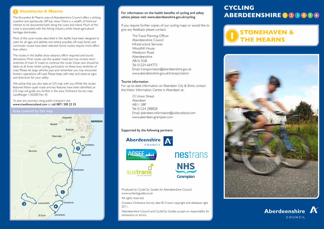
CYCLING ABERDEENSHIRE STONEHAVEN & THE MEARNS ABERDEEN Stonehaven Inverbervie Johnshaven Portlethen Newtonhill Banchory Westhill Laurencekirk Peterculter Cove Kingswells Bieldside St Cyrus Area covered by this map For information on the health benefits of cycling and safety advice please visit: www.aberdeenshire.gov.uk/cycling If you require further copies of our cycling maps or would like to give any feedback please contact: The Travel Planning Officer Aberdeenshire Council Infrastructure Services Woodhill House Westburn Road Aberdeenshire AB16 5GB Tel: 01224 664773 Email: [email protected] www.aberdeenshire.gov.uk/transportation Tourist information For up-to-date information on Aberdeen City & Shire, contact the Visitor Information Centre in Aberdeen at: 23 Union Street Aberdeen AB11 5BP Tel: 01224 288828 Email: [email protected] www.aberdeen-grampian.com Stonehaven & Mearns The Kincardine & Mearns area of Aberdeenshire Council offers a striking coastline and spectacular cliff top views. There is a wealth of historical interest to be discovered both along the coast and inland. Much of the coast is associated with the fishing industry, while inland agricultural heritage dominates. Most of the cycle routes described in this leaflet have been designed to cater for all ages and abilities and where possible, off-road, family and commuter routes have been selected. Some routes require more effort than others. The routes in this leaflet show distance, effort required and tourist attractions. Most routes use the quieter roads but may involve short stretches of main ‘A’ roads to continue the route. Great care should be taken at all times whilst cycling, particularly on these busy stretches of road. Please let large vehicles pass and remember you may encounter forestry operations off-road. Please keep well clear and observe signs and diversions for your safety. We advise that you also take an O.S map with you. While the routes featured follow quiet roads and key features have been identified, an O.S map will guide you further in the area. Ordnance Survey map: LandRanger 1:50,000 No. 45. To plan any journeys using public transport visit www.travelinescotland.com or call 0871 200 22 33 NHS Grampian Grampian Supported by the following partners: Produced by CycleCity Guides for Aberdeenshire Council. www.cyclecityguides.co.uk All rights reserved Contains Ordnance Survey data © Crown copyright and database right 2011. Aberdeenshire Council and CycleCity Guides accept no responsiblity for omisssions or errors.
Transcript of NHS - Home - Aberdeenshire Councilaberdeenshire.gov.uk/media/2437/cover_004.pdf · · 2015-09-02...
CYCLING ABERDEENSHIRE
STONEHAVEN & THE MEARNS
ABERDEEN
Stonehaven
Inverbervie
Johnshaven
Portlethen
Newtonhill
Banchory
Westhill
Laurencekirk
Peterculter
Dyce
Cove
Denmore
Kingswells
Bieldside
St Cyrus
Area covered by this map
For information on the health benefits of cycling and safety advice please visit: www.aberdeenshire.gov.uk/cycling
If you require further copies of our cycling maps or would like to give any feedback please contact:
The Travel Planning OfficerAberdeenshire CouncilInfrastructure ServicesWoodhill HouseWestburn RoadAberdeenshire AB16 5GBTel: 01224 664773Email: [email protected] www.aberdeenshire.gov.uk/transportation
Tourist informationFor up-to-date information on Aberdeen City & Shire, contact the Visitor Information Centre in Aberdeen at:
23 Union Street Aberdeen AB11 5BP Tel: 01224 288828 Email: [email protected] www.aberdeen-grampian.com
Stonehaven & Mearns
The Kincardine & Mearns area of Aberdeenshire Council offers a striking coastline and spectacular cliff top views. There is a wealth of historical interest to be discovered both along the coast and inland. Much of the coast is associated with the fishing industry, while inland agricultural heritage dominates.
Most of the cycle routes described in this leaflet have been designed to cater for all ages and abilities and where possible, off-road, family and commuter routes have been selected. Some routes require more effort than others.
The routes in this leaflet show distance, effort required and tourist attractions. Most routes use the quieter roads but may involve short stretches of main ‘A’ roads to continue the route. Great care should be taken at all times whilst cycling, particularly on these busy stretches of road. Please let large vehicles pass and remember you may encounter forestry operations off-road. Please keep well clear and observe signs and diversions for your safety.
We advise that you also take an O.S map with you. While the routes featured follow quiet roads and key features have been identified, an O.S map will guide you further in the area. Ordnance Survey map: LandRanger 1:50,000 No. 45.
To plan any journeys using public transport visit www.travelinescotland.com or call 0871 200 22 33
NHSGrampianGrampian
Supported by the following partners:
Produced by CycleCity Guides for Aberdeenshire Council. www.cyclecityguides.co.uk
All rights reserved
Contains Ordnance Survey data © Crown copyright and database right 2011.
Aberdeenshire Council and CycleCity Guides accept no responsiblity for omisssions or errors.