NextGen Ain’t Peanuts at Snoopy’s Airport · who focuses on air traffic control issues. Horizon...
4
VOLUME 50 Winter 2014 January 2014 — What do the names Woodstock, Lucy and Pigpen bring to mind? For pilots flying into Charles M. Schulz — Sonoma County Airport, those are the waypoints that guide them along the NextGen approach to runway 32. The airport, named for the famed Peanuts cartoonist who lived nearby, sports Snoopy dressed as a World War I flying ace on its logo. Nestled in the heart of Northern California Wine Country, the airport is surrounded by tall mountains. When the fog rolls in from the Pacific Ocean, as it often does mornings and evenings, it shrouds the view of the runway. While this kind of weather is perfect for growing grapes, it’s not an ideal situation when landing aircraft. Fortunately, the FAA has taken a cue from Linus van Pelt and provided the airport with a safety blanket; the NextGen procedure enables pilots of equipped aircraft to land even when the approach to the runway is covered in fog. Pilots need a clear view of the runway to land. When fog obscures the view, they have to rely on instruments in the cockpit, which pick up a signal from navigation equipment on the ground at the airport. At Charles M. Schulz, there is only one Instrument Landing System (ILS). But the NextGen approach relies on GPS and uses a technology that boosts the accuracy of GPS satellite signals so pilots know, within a few feet, their exact position in space. Flying the procedure, known as Localizer Performance with Vertical Guidance (LPV), pilots descend to an altitude of 455 feet using their onboard instruments before they have to see the runway to land at Charles M. Schulz. The satellite-based approach “provides a great backup (to the ILS) and is another means for us to get our passengers into airports we otherwise could not,” said Steve Castellano, a Horizon Air pilot who focuses on air traffic control issues. Horizon Air, whose entire aircraft fleet is equipped to fly LPV approaches, uses the NextGen approach into Charles M. Schulz on a regular basis in all sorts of weather conditions. Pilots of the small, general aviation aircraft that frequently fly into Charles M. Schulz are also benefiting from the LPV approach. Jim McCord, a general aviation pilot and member of the FAA Safety Team, said the NextGen approach makes it much easier to keep track of the aircraft’s exact position. This is especially important as the terrain within a few miles of the airport rises as high as 4,600 feet above the airport’s elevation. McCord prefers the NextGen procedure to the ILS approach also because it is simpler to fly. As a certificated flight instructor, McCord trains student pilots to fly the NextGen procedure, which is easily programmed into the aircraft’s navigation system. The FAA is in the process of adding an LPV approach to the second of the two runways at Charles M. Schulz. This is especially important as the main runway, and the only runway with an ILS, will be closed for construction for several months next year and the ILS will be out of service. - Reprint from the FAA NextGen Performance Snapshots (NPS) website at http://www.faa.gov/ nextgen/snapshots/ stories/?slide=30 Inside ... http://gps.faa.gov Federal Aviation Administration 800 Independence Avenue, SW Washington, DC 20591 The SatNav News is produced by the Navigation Programs AJM-32 branch of the Federal Aviation Administration (FAA). This newsletter provides informa- tion on the Global Positioning System (GPS), the Wide Area Augmentation System (WAAS) and the Ground Based Augmentation System (GBAS). 1 NextGen Ain’t Peanuts at Snoopy’s Airport 2 ExpressJet WAAS Project Advances 2 WAAS Dual Frequency Operations Segment 1 2 WAAS and ADS-B 3 GBAS Update 4 What’s New on the Web 4 Satellite Navigation Approach Procedures Update We’re collecting testimonials about the benefits of Wide Area Augmentation System (WAAS) navigation from users. If you are a pilot, passenger, airport manager, airline employee, or are involved in aviation in any capacity - whether you fly fixed-wing or vertical flight aircraft - we want to hear from you! Please send your stories and contact information to Mary Ann Davis at [email protected] Tell Us Your WAAS Story NextGen Ain’t Peanuts at Snoopy’s Airport Source: sonomacountyairport.org
Transcript of NextGen Ain’t Peanuts at Snoopy’s Airport · who focuses on air traffic control issues. Horizon...

VOLUME 50Winter 2014
January 2014 — What do the names Woodstock, Lucy and Pigpen bring to mind? For pilots flying into Charles M. Schulz — Sonoma County Airport, those are the waypoints that guide them along the NextGen approach to runway 32. The airport, named for the famed Peanuts cartoonist who lived nearby, sports Snoopy dressed as a World War I flying ace on its logo.
Nestled in the heart of Northern California Wine Country, the airport is surrounded by tall mountains. When the fog rolls in from the Pacific Ocean, as it often does mornings and evenings, it shrouds the view of the runway. While this kind of weather is perfect for growing grapes, it’s not an ideal situation when landing aircraft. Fortunately, the FAA has taken a cue from Linus van Pelt and provided the airport with a safety blanket; the NextGen procedure enables pilots of equipped aircraft to land even when the approach to the runway is covered in fog.
Pilots need a clear view of the runway to land. When fog obscures the view, they have to rely on instruments in the cockpit, which pick up a signal from navigation equipment on the ground at the airport. At Charles M. Schulz, there is only one Instrument Landing System (ILS).
But the NextGen approach relies on GPS and uses a technology that boosts the accuracy of GPS satellite signals so pilots know, within a few feet, their exact position in space. Flying the procedure, known as Localizer Performance with Vertical Guidance (LPV), pilots descend to an altitude of 455 feet using their onboard instruments before they have to see the runway to land at Charles M. Schulz.
The satel l ite-based approach “provides a great backup (to the ILS) and is another means for us to get our passengers into airports we otherwise could not,” said Steve Castellano, a Horizon Air pilot who focuses on air traffic control issues. Horizon Air, whose entire aircraft fleet is equipped to fly LPV approaches, uses the NextGen approach into Charles M. Schulz on a regular basis in all sorts of weather conditions.
P i lo ts o f the sma l l , genera l aviation aircraft that frequently fly into Charles M. Schulz are also benefiting from the LPV approach. Jim McCord, a general aviation pilot and member of the FAA Safety Team, said the NextGen approach makes it much easier to keep track of the aircraft’s exact position. This is especially important as the terrain within a few miles of the airport rises as high as 4,600 feet above the airport’s elevation.
McCord prefers the Nex tGen procedure to the ILS approach also because it is simpler to fly. As a certificated flight instructor, McCord trains student pilots to fly the NextGen procedure, which is easily programmed into the aircraft’s navigation system.
The FAA is in the process of adding an LPV approach to the second of the two runways at Charles M. Schulz. This is especially important as the main runway, and the only runway with an ILS, will be closed for construction for several months next year and the ILS will be out of service. - Reprint from the FAA NextGen Performance Snapshots (NPS) website at http://www.faa.gov/ nextgen/snapshots/ stories/?slide=30
Inside ...
http://gps.faa.gov
Federal Aviation Administration 800 Independence Avenue, SW Washington, DC 20591
The SatNav News is produced by the Navigation Programs AJM-32 branch of the Federal Aviation Administration (FAA). This newsletter provides informa-tion on the Global Positioning System (GPS), the Wide Area Augmentation System (WAAS) and the Ground Based Augmentation System (GBAS).
1 NextGen Ain’t Peanuts at Snoopy’s Airport
2 ExpressJet WAAS Project Advances
2 WAAS Dual Frequency Operations Segment 1
2 WAAS and ADS-B
3 GBAS Update
4 What’s New on the Web
4 Satellite Navigation Approach Procedures Update
We’re collecting testimonials about the benefits of Wide Area Augmentation System (WAAS) navigation from users. If you are a pilot, passenger, airport manager, airline employee, or are involved in aviation in any capacity - whether you fly fixed-wing or vertical flight aircraft - we want to hear from you! Please send your stories and contact information to Mary Ann Davis [email protected]
Tell Us Your WAAS Story
NextGen Ain’t Peanuts at Snoopy’s Airport
Source: sonomacountyairport.org
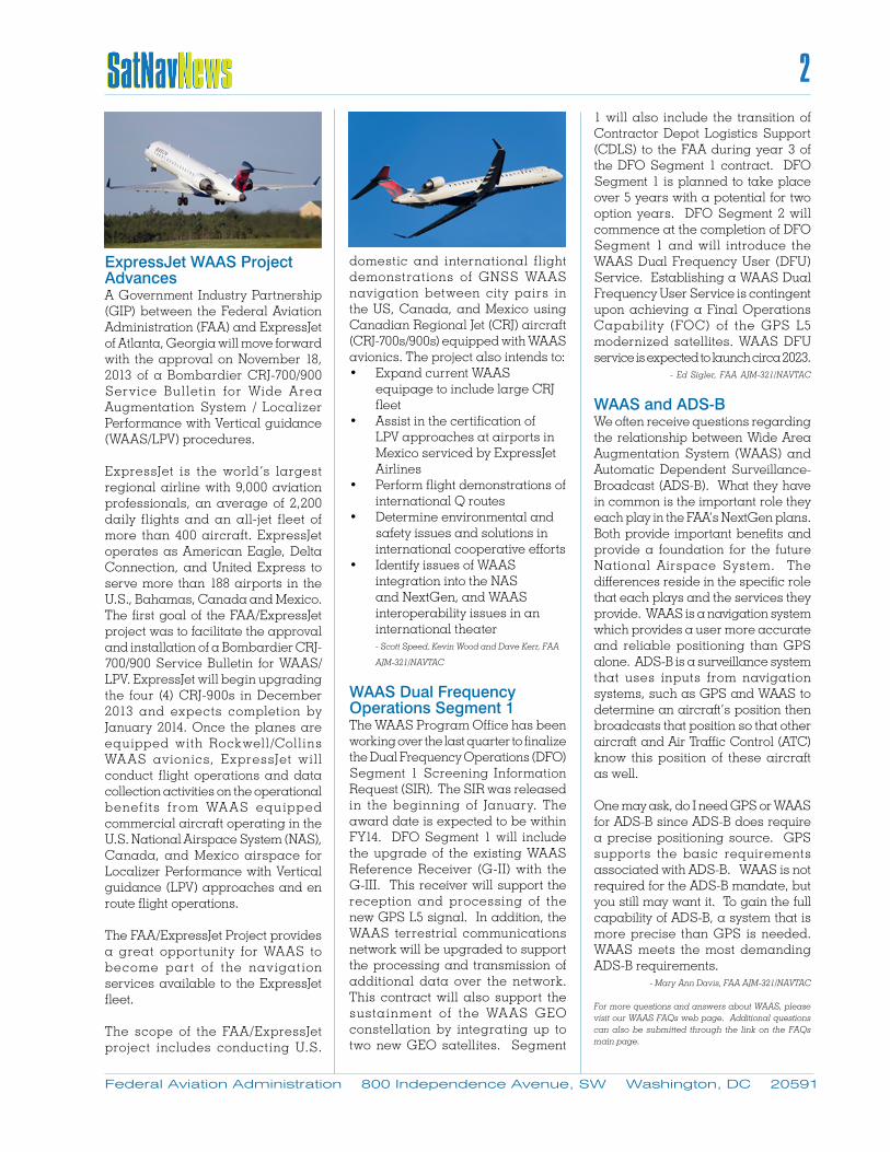
ExpressJet WAAS Project AdvancesA Government Industry Partnership (GIP) between the Federal Aviation Administration (FAA) and ExpressJet of Atlanta, Georgia will move forward with the approval on November 18, 2013 of a Bombardier CRJ-700/900 Serv ice Bul let in for Wide Area Augmentation System / Localizer Performance with Vertical guidance (WAAS/LPV) procedures.
ExpressJet is the world’s largest regional airline with 9,000 aviation professionals, an average of 2,200 daily flights and an all-jet fleet of more than 400 aircraft. ExpressJet operates as American Eagle, Delta Connection, and United Express to serve more than 188 airports in the U.S., Bahamas, Canada and Mexico.The first goal of the FAA/ExpressJet project was to facilitate the approval and installation of a Bombardier CRJ-700/900 Service Bulletin for WAAS/LPV. ExpressJet will begin upgrading the four (4) CRJ-900s in December 2013 and expects completion by January 2014. Once the planes are equipped with Rockwell/Coll ins WA AS av ionics, ExpressJet wi l l conduct flight operations and data collection activities on the operational benef its f rom WA AS equipped commercial aircraft operating in the U.S. National Airspace System (NAS), Canada, and Mexico airspace for Localizer Performance with Vertical guidance (LPV) approaches and en route flight operations.
The FAA/ExpressJet Project provides a great opportunity for WAAS to become part of the nav igation services available to the ExpressJet fleet.
The scope of the FAA/ExpressJet project includes conducting U.S.
domestic and international flight demonstrations of GNSS WA AS navigation between city pairs in the US, Canada, and Mexico using Canadian Regional Jet (CRJ) aircraft (CRJ-700s/900s) equipped with WAAS avionics. The project also intends to:• Expand current WAAS
equipage to include large CRJ fleet
• Assist in the certification of LPV approaches at airports in Mexico serviced by ExpressJet Airlines
• Perform flight demonstrations of international Q routes
• Determine environmental and safety issues and solutions in international cooperative efforts
• Identify issues of WAAS integration into the NAS and NextGen, and WAAS interoperability issues in an international theater - Scott Speed, Kevin Wood and Dave Kerr, FAA
AJM-321/NAVTAC
WAAS Dual Frequency Operations Segment 1 The WAAS Program Office has been working over the last quarter to finalize the Dual Frequency Operations (DFO) Segment 1 Screening Information Request (SIR). The SIR was released in the beginning of January. The award date is expected to be within FY14. DFO Segment 1 will include the upgrade of the existing WAAS Reference Receiver (G-II) with the G-III. This receiver will support the reception and processing of the new GPS L5 signal. In addition, the WAAS terrestrial communications network will be upgraded to support the processing and transmission of additional data over the network. This contract will also support the sustainment of the WA AS GEO constellation by integrating up to two new GEO satellites. Segment
1 will also include the transition of Contractor Depot Logistics Support (CDLS) to the FAA during year 3 of the DFO Segment 1 contract. DFO Segment 1 is planned to take place over 5 years with a potential for two option years. DFO Segment 2 will commence at the completion of DFO Segment 1 and will introduce the WAAS Dual Frequency User (DFU) Service. Establishing a WAAS Dual Frequency User Service is contingent upon achieving a Final Operations Capability (FOC) of the GPS L5 modernized satellites. WAAS DFU service is expected to launch circa 2023. - Ed Sigler, FAA AJM-321/NAVTAC
WAAS and ADS-B We often receive questions regarding the relationship between Wide Area Augmentation System (WAAS) and Automatic Dependent Surveillance-Broadcast (ADS-B). What they have in common is the important role they each play in the FAA’s NextGen plans. Both provide important benefits and provide a foundation for the future National Airspace System. The differences reside in the specific role that each plays and the services they provide. WAAS is a navigation system which provides a user more accurate and reliable positioning than GPS alone. ADS-B is a surveillance system that uses inputs from navigation systems, such as GPS and WAAS to determine an aircraft’s position then broadcasts that position so that other aircraft and Air Traffic Control (ATC) know this position of these aircraft as well.
One may ask, do I need GPS or WAAS for ADS-B since ADS-B does require a precise positioning source. GPS supports the basic requirements associated with ADS-B. WAAS is not required for the ADS-B mandate, but you still may want it. To gain the full capability of ADS-B, a system that is more precise than GPS is needed. WAAS meets the most demanding ADS-B requirements. - Mary Ann Davis, FAA AJM-321/NAVTAC
For more questions and answers about WAAS, please visit our WAAS FAQs web page. Additional questions can also be submitted through the link on the FAQs main page.
Federal Aviation Administration 800 Independence Avenue, SW Washington, DC 20591
2

GBAS UpdateCategory I (CAT I) Ground Based Augmentation System (GBAS) has been operational for public use at Newark Liberty International airport (EWR) since September 2012 and George Bush Intercontinental Airport (IAH) in Houston, Texas beginning in April 2013.
The Houston and Newark GBAS installations are part of a Government Industry Project (GIP) with the Federal Aviation Administration (FAA), United Airlines, Honeywell Aerospace and the respective airport authorities for Newark and Houston. The projects are intended to establish operational experience with an FAA approved non-Federal (non-Fed) GBAS system and the user community (air traffic control, airports and airlines). They are owned and operated by the respective airport authorities. The operational experience gained from these non-Fed CAT I systems will facilitate the development of Category III (CAT III) GBAS systems.
The systems at Newark and Houston now provide a GBAS city pair for use by United Airlines and increased operational experience with the technology. As of November 2013, United Airlines has over 90 GBAS equipped aircraft (Boeing 737/Boeing 787) capable of utilizing the GBAS Landing System (GLS) approaches at IAH and EWR. United Airlines aircrews have logged over 240 GBAS approaches at Newark and Houston. In addition to United Aircrews gaining valuable experience with the existing CAT I GBAS, United (with assistance from Boeing) has begun discussions with the FAA aircraft certification office to pursue a GBAS Autoland capability for their B737 fleet followed by possible approval of CAT II GBAS operations using current GBAS CAT I ground systems and avionics.
Both major Original Equipment Manufacturers (OEMs), Boeing and Airbus, provide GBAS capability in their fleets. GBAS is available as an option in B737 aircraft and standard
equipment in B787 and B747-8 aircraft. A IRBUS implemented GBAS as optional equipment in the A320 and A380 and plans to certify A330/340 and A350 with GBAS capability. Embraer and Bombardier are considering GBAS avionics equipage for their next generation aircraft.
The goal of the FAA GBAS research and development effort over the next few years is to produce an operationally approved CAT I I I system. The strategy is to evolve the architecture developed and approved for a single frequency GBAS CAT-I service and improve this architecture to provide CAT II/III service. , An ICAO Navigation Systems Panel baselined standards for GBAS GAST-D, a service type equivalent to ILS CAT III, in a proposed amendment to the Annex 10 Standards and Recommended Practices (SARPS). Current FAA GAST-D efforts focus on reducing technical risk through prototyping and req u i rements va l ida t ion. This approach is consistent with international GBAS efforts. An FAA-owned SLS-4000 installed in Atlantic City International Airport (ACY) will continue to be used as an interim platform to develop and validate Category III requirements under this project.
The Boeing Company installed their
own GBAS SLS-4000 at Moses Lake, Washington and Charleston, South Carolina as a private system for the sole use of Boeing to certify Boeing aircraft and aircrews. Boeing and the FAA have signed a Memorandum of Understanding (MOU) to collaborate on airborne GBAS advancements. Boeing plans to use the Moses Lake system for validation and testing of GBAS CAT II/III avionics and aircraft interfaces. The FAA is working with Boeing to gain insight into their CAT III aircraft approval strategy and leverage their CAT III efforts for FAA validation work. Boeing plans on GBAS CAT III flight test with the Boeing eco-Demonstrator in early 2014.
The FAA GBAS team continues to work with the international community on the implementation and development of GBAS through the International GBAS Working Group (IGWG). The IGWG is co-chaired by FAA and EUROCONTROL and serves as the forum for international GBAS technical and operational information exchange, coordination of GBAS activ it ies, and establishment of joint projects, analysis tools, and documents for GBAS development and implementation. Besides the FAA and EUROCONTROL, IGWG members include internat ional service providers (such as Australia,
Federal Aviation Administration 800 Independence Avenue, SW Washington, DC 20591
3

Federal Aviation Administration 800 Independence Avenue, SW Washington, DC 20591
4
Germany, Spain, the United Kingdom, Switzerland, Japan, Italy, Russia, and Korea), European and U.S avionics industry, airline representatives, Boeing and Airbus. Fourteen nations presently have GBAS related activities in one form or another from concept development and research prototype activities to actual implementation, some with airline GBAS operations under revenue. The last IGWG was hosted by the FAA and Boeing in Everett, WA on June 4 -7, 2013 with over 80 participants.
With a new year upon us, the GBAS office remains hopeful that additional U.S. and foreign carriers will add GBAS to their operational capability as domestic and foreign airports add GBAS to their navigational aid offerings. - Dieter Guenter, FAA AJM-321/NAVTAC
What’s New on the Web!Where can you find FAA Satellite Navigation Program information in between editions of the SATNAV News? Please visit our website - http://gps.faa.gov. Recently, we have updated WAAS Frequently Asked Questions; added the latest WAAS Quarterly Status Report; and posted updated numbers on WAAS approach procedure development. Also, on our website, you can find information about how GPS, WAAS, and the Ground Based Augmentation System (GBAS) work; an archive of past SATNAV News editions; and fact sheets. We are always looking for ways to improve the website and love your suggestions, so please feel free to send them to [email protected]. In the meantime, we continue to make updates to existing pages.
More information is available at https://www.faa.gov/air_traffic/flight_info/aeronav/procedures/ifp_inven-tory_summary/
Satellite Navigation Approach Procedures Update The Satel l i te-based Approach Procedures table ref lects the continuing growth of all types of satellite navigation approach procedures. For comparison purposes, we also include a table noting the recent inventory of Instrument Approach Procedures Based on Conventional NAVAIDs.
More detailed information about satellite based instrument approach procedures , p lease v i s i t our GPS/WAAS Approach Procedures page at http://www.faa.gov/about/office_org/ headquarters_offices/ato/service_units/techops/navservices/gnss/ approaches/index.cfm) - Mary Ann Davis, FAA AJM-321/NAVTAC