New REVISED Current Cynthiana SUA Report Studies and Reports... · Final Report Prepared for: ......
28
Transcript of New REVISED Current Cynthiana SUA Report Studies and Reports... · Final Report Prepared for: ......

CITY OF CYNTHIANA Harrison County, Kentucky
SSMMAALLLL UURRBBAANN AARREEAA
TTRRAANNSSPPOORRTTAATTIIOONN SSTTUUDDYY FFiinnaall RReeppoorrtt
Prepared for:
KENTUCKY TRANSPORTATION CABINET
DIVISION of PLANNING
Prepared by:
June, 2009

TABLE OF CONTENTS
Page
ES EXECUTIVE SUMMARY................................................................................................................ES-1
1.0 INTRODUCTION ..................................................................................................................................1
1.1 Study Purpose ......................................................................................................................................1
1.2 Programming and Other Projects .........................................................................................................1
2.0 PROJECT LOCATION AND EXISTING CONDITIONS ......................................................................3
2.1 Project Location ....................................................................................................................................3
2.2 Existing Conditions ...............................................................................................................................4
2.2.1 Average Daily Traffic ............................................................................................................................4
2.2.2 Level of Service ....................................................................................................................................4
2.2.3 Crash Analysis......................................................................................................................................7
3.0 PROJECT TEAM, ADVISORY COMMITTEE, AND PUBLIC INVOLVEMENT .................................8
3.1 KYTC Project Team..............................................................................................................................8
3.2 Advisory Committee..............................................................................................................................8
3.3 Public Involvement................................................................................................................................9
4.0 ENVIRONMENTAL AND SOCIOECONOMIC OVERVIEW ..............................................................10
4.1 Environmental Footprint .....................................................................................................................10
4.2 Environmental Justice ........................................................................................................................10
5.0 RECOMMENDATIONS ......................................................................................................................12
5.1 KYTC Short -Term Projects................................................................................................................22
5.2 KYTC Long -Term Projects ................................................................................................................37
5.3 Local Projects .....................................................................................................................................48
LIST OF FIGURES
Figure 1 Project Study Area .......................................................................................................................3 Figure 2 Census Tracts and Block Groups in the Study Area ................................................................. 11
LIST OF TABLES
Table 1 HIS Base Data Route Information.................................................................................................5 Table 2 Crash Data: Roadway Segments Where CRF>1 ........................................................................ 7 Table 3A Recommended KYTC Short-Term Projects................................................................................13 Table 3B Recommended KYTC Long-Term Projects ................................................................................16 Table 3C Recommended Local Projects ....................................................................................................18
Page i
TABLE OF CONTENTS (Continued)
LIST OF APPENDICES
Appendix A Exhibits: Exhibit 1: Project Area Location Exhibit 2: Current Roadway Deficiencies Exhibit 3: Environmental Footprint Exhibit 4: Project Recommendations Appendix B Project Team Meeting Minutes Appendix C Advisory Committee Meeting Minutes and Public Survey Appendix D Environmental Justice Report Appendix E SYP and PIF Projects
Page ii
EXECUTIVE SUMMARY Project Description The Cynthiana Small Urban Area (SUA) Transportation Study was conducted for the Kentucky Transportation Cabinet (KYTC), Division of Planning in cooperation with the Bluegrass Area Development District. Small Urban Area Transportation Studies are conducted in municipalities that range in population from 5,000 to 50,000 residents. Cynthiana was an eligible municipality to undergo an SUA Study because it has a population of 6,272 residents. The goal of this SUA transportation study was to identify improvements to the transportation system within and surrounding the Cynthiana urban area. Special attention was given to those improvements that address the travel needs and safety concerns within the study area. The focus on the transportation improvements was not specifically adding transportation systems, but maximizing the current transportation assets on the existing state-controlled route system. For this study, Qk4 served KYTC as the project consultant. A project team approach was employed. The team was comprised of members from KYTC, Bluegrass Area Development District (BGADD), and Qk4. Steps taken by the project team included analyzing road system data, identification of problem spots, multiple field reviews, and identification and prioritization of improvement strategies. An Advisory Committee was also involved and was comprised of local elected officials and stakeholders. Public input was gathered via an online public comment survey. Study Location
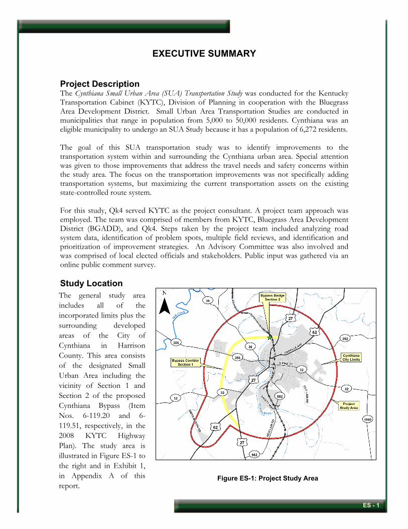
The general study area includes all of the incorporated limits plus the surrounding developed areas of the City of Cynthiana in Harrison County. This area consists of the designated Small Urban Area including the vicinity of Section 1 and Section 2 of the proposed Cynthiana Bypass (Item Nos. 6-119.20 and 6-119.51, respectively, in the 2008 KYTC Highway Plan). The study area is illustrated in Figure ES-1 to the right and in Exhibit 1, in Appendix A of this report.
Figure ES-1: Project Study Area
ES - 1
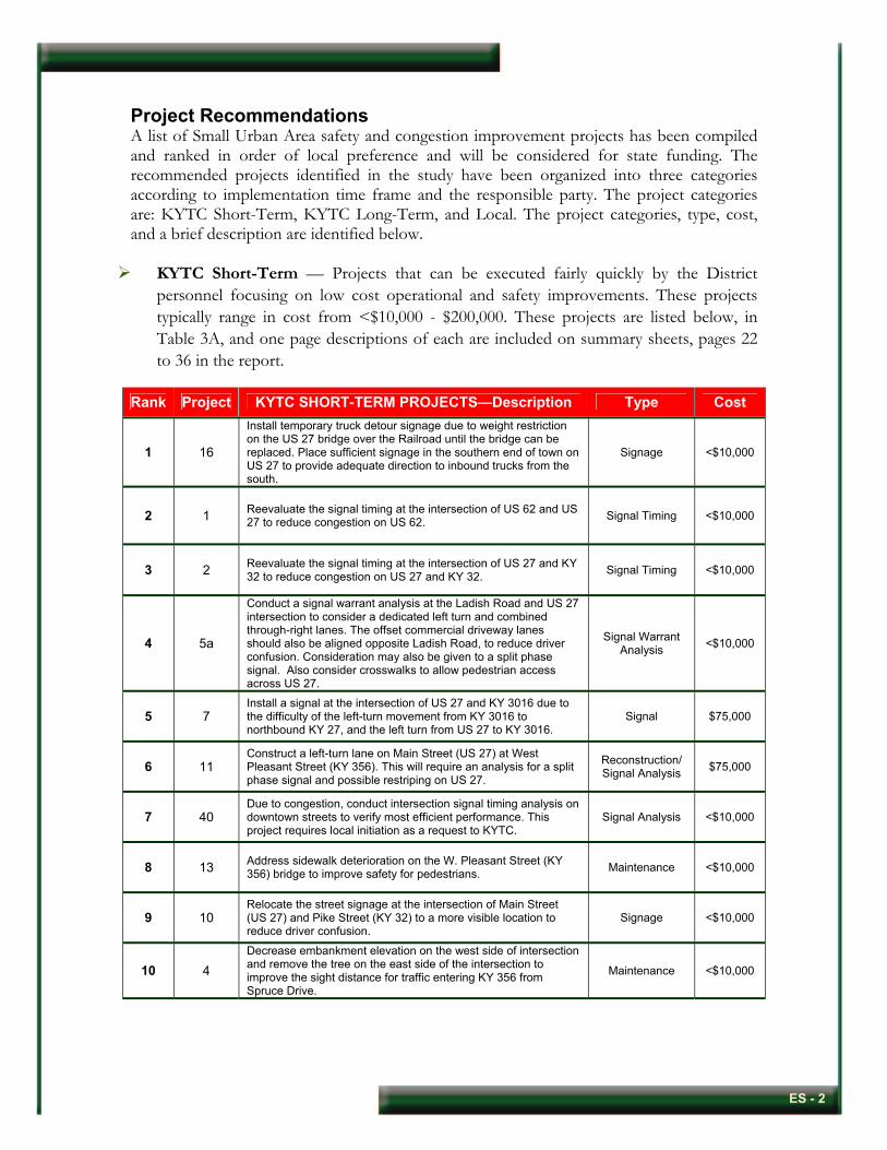
Project Recommendations A list of Small Urban Area safety and congestion improvement projects has been compiled and ranked in order of local preference and will be considered for state funding. The recommended projects identified in the study have been organized into three categories according to implementation time frame and the responsible party. The project categories are: KYTC Short-Term, KYTC Long-Term, and Local. The project categories, type, cost, and a brief description are identified below.
KYTC Short-Term — Projects that can be executed fairly quickly by the District personnel focusing on low cost operational and safety improvements. These projects typically range in cost from <$10,000 - $200,000. These projects are listed below, in Table 3A, and one page descriptions of each are included on summary sheets, pages 22 to 36 in the report.
Rank Project KYTC SHORT-TERM PROJECTS—Description Type Cost
1 16
Install temporary truck detour signage due to weight restriction on the US 27 bridge over the Railroad until the bridge can be replaced. Place sufficient signage in the southern end of town on US 27 to provide adequate direction to inbound trucks from the south.
Signage <$10,000
2 1 Reevaluate the signal timing at the intersection of US 62 and US 27 to reduce congestion on US 62. Signal Timing <$10,000
3 2 Reevaluate the signal timing at the intersection of US 27 and KY 32 to reduce congestion on US 27 and KY 32. Signal Timing <$10,000
4 5a
Conduct a signal warrant analysis at the Ladish Road and US 27 intersection to consider a dedicated left turn and combined through-right lanes. The offset commercial driveway lanes should also be aligned opposite Ladish Road, to reduce driver confusion. Consideration may also be given to a split phase signal. Also consider crosswalks to allow pedestrian access across US 27.
Signal Warrant Analysis <$10,000
5 7 Install a signal at the intersection of US 27 and KY 3016 due to the difficulty of the left-turn movement from KY 3016 to northbound KY 27, and the left turn from US 27 to KY 3016.
Signal $75,000
6 11 Construct a left-turn lane on Main Street (US 27) at West Pleasant Street (KY 356). This will require an analysis for a split phase signal and possible restriping on US 27.
Reconstruction/ Signal Analysis $75,000
7 40 Due to congestion, conduct intersection signal timing analysis on downtown streets to verify most efficient performance. This project requires local initiation as a request to KYTC.
Signal Analysis <$10,000
8 13 Address sidewalk deterioration on the W. Pleasant Street (KY 356) bridge to improve safety for pedestrians. Maintenance <$10,000
9 10 Relocate the street signage at the intersection of Main Street (US 27) and Pike Street (KY 32) to a more visible location to reduce driver confusion.
Signage <$10,000
10 4 Decrease embankment elevation on the west side of intersection and remove the tree on the east side of the intersection to improve the sight distance for traffic entering KY 356 from Spruce Drive.
Maintenance <$10,000
ES - 2
Rank Project KYTC SHORT-TERM PROJECTS—Description Type Cost
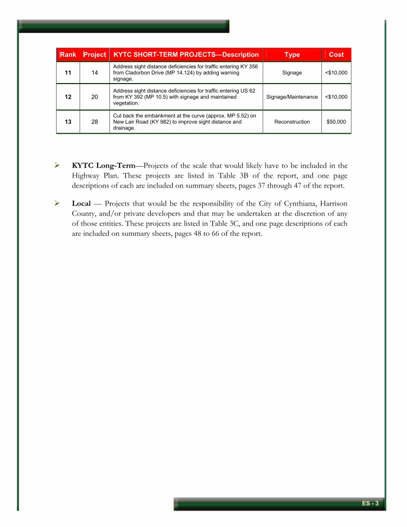
11 14 Address sight distance deficiencies for traffic entering KY 356 from Cladorbon Drive (MP 14.124) by adding warning signage.
Signage <$10,000
12 20 Address sight distance deficiencies for traffic entering US 62 from KY 392 (MP 10.5) with signage and maintained vegetation.
Signage/Maintenance <$10,000
13 28 Cut back the embankment at the curve (approx. MP 5.52) on New Lair Road (KY 982) to improve sight distance and drainage.
Reconstruction $50,000
KYTC Long-Term—Projects of the scale that would likely have to be included in the Highway Plan. These projects are listed in Table 3B of the report, and one page descriptions of each are included on summary sheets, pages 37 through 47 of the report.
Local — Projects that would be the responsibility of the City of Cynthiana, Harrison County, and/or private developers and that may be undertaken at the discretion of any of those entities. These projects are listed in Table 3C, and one page descriptions of each are included on summary sheets, pages 48 to 66 of the report.
ES - 3

1.0 INTRODUCTION
1.1 Study Purpose
This Cynthiana Small Urban Area (SUA) Transportation Study was conducted for the Kentucky Transportation Cabinet (KYTC), Division of Planning, in cooperation with the Bluegrass Area Development District with the goal of identifying and improving the transportation system in and surrounding the Cynthiana SUA. Qk4 has been retained by KYTC as the project consultant.
The focus on the improvements is not specifically adding transportation systems, but maximizing the current transportation assets on the existing state-controlled route system. One criterion that must be met in order for a municipality to be eligible for an SUA transportation study is that it must range from 5,000 to 50,000 in size of population. Cynthiana falls within this range with a population of 6,272 residents.
This planning process included the following tasks:
• Review and evaluate the KYTC Division of Planning’s Highway Information System (HIS) and Collision Reports Analysis for Safer Highways (CRASH) data.
• Establish a project team to guide the study effort • Consult with local officials to obtain input • Identify potential problem areas • Conduct field reviews to study problems • Identify possible solutions and estimate project costs • Develop recommendations and prioritized projects
1.2 Programming and Other Projects Several projects in and near Cynthiana are listed in the Kentucky 2008 Highway Plan (FY 2008-2014). These projects were taken into consideration during the evaluation of the study area for compatibility and/or redundancy with the proposed projects. These projects are:
• Item 6-119.20: Construct Section One of Cynthiana Bypass from US 27 South to US 27 North, excluding bridge over Licking River (FY 2010) See next bullet.
• Item 6-119.51: Construct Cynthiana Bypass bridge over Licking River (FY 2010) • Item 6-1052.00: Replace bridge over Mill Creek 2.5 miles west of junction with KY 36,
approximately 1.0 mile west of city limits (FY 2010) • Item 6-1053.00: Replace bridge over CSX Railroad 0.5 mile north of junction with US 62E
(FY 2009) In addition to the Highway Plan projects that were identified, unscheduled projects identified with Project Identification Form (PIF) data in the study area are:
• B0027 107.10: Address safety and congestion on US 27N • D0032 2.00: Improve access to Business Park
Page 1
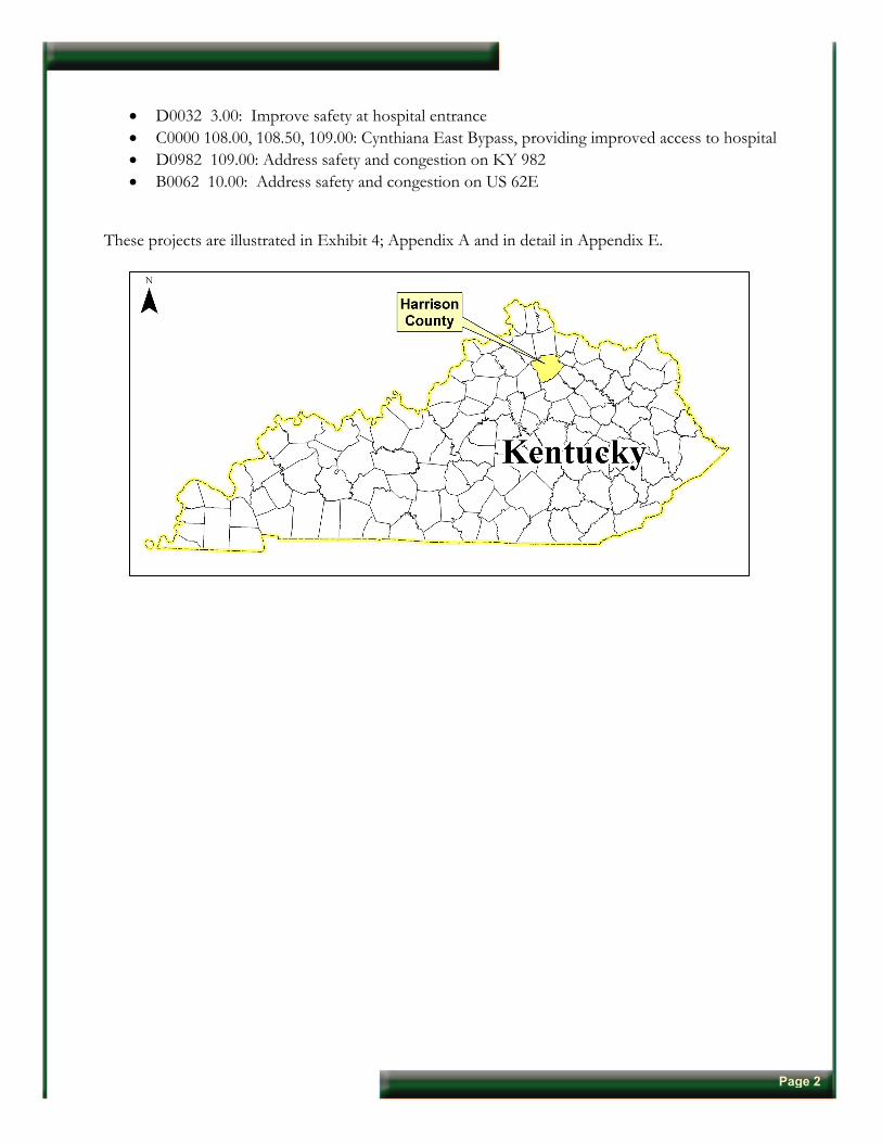
• D0032 3.00: Improve safety at hospital entrance • C0000 108.00, 108.50, 109.00: Cynthiana East Bypass, providing improved access to hospital • D0982 109.00: Address safety and congestion on KY 982 • B0062 10.00: Address safety and congestion on US 62E
These projects are illustrated in Exhibit 4; Appendix A and in detail in Appendix E.
Page 2

2.0 PROJECT LOCATION AND EXISTING CONDITIONS
2.1 Project Location The general study area includes all of the incorporated limits plus the surrounding developed areas of the city of Cynthiana in Harrison County. This area consists of the designated Small Urban Area including the proposed western Cynthiana Bypass. The study area is illustrated below and in Exhibit 1, in Appendix A.
Figure 1: Project Study Area
Page 3
2.2 Existing Conditions Data on the existing conditions in the study area were taken from the Division of Planning’s HIS database. Table 1, below, shows some general route information for the City of Cynthiana. Current roadway deficiencies are illustrated in Exhibit 2 in Appendix A. In particular, Exhibit 2 shows roadway segments with poor composite adequacy ratings (less than 20th percentile), poor levels of service (D and E), narrow lane widths (less than 11 feet), deficient volume/service flows (greater than 0.7), and areas of high crashes (Critical Rate Factor greater than 1.00). These same deficiencies are also highlighted in Table 1.
2.2.1 Average Daily Traffic The highest volumes of average daily traffic (ADT) in the study area occurs on US 27 near the Licking River Bridge with 17,100 vehicles per day (vpd). US 27 between its southern junction with US 62 and its eastern junction with KY 32 (Pike Street) is the only highway facility with an ADT in excess of 10,000 vpd. Traffic volumes on US 62 peak at 7,740 vpd southwest of town and west of its junction with US 27. Other locations with relatively high ADT include KY 32 east of its intersection with Elmarch Avenue (7,080 vpd) and KY 36 at the Licking River Bridge (6,500 vpd).
2.2.2 Level of Service Level of service (LOS) is a qualitative measure of expected traffic conflicts, delay, driver discomfort, and congestion. Levels of service are described according to a letter rating system (similar to school grades) ranging from LOS A (free flow, minimal or no delays—best conditions) to LOS F (stop and go conditions, very long delays—worst conditions). For intersections, the Highway Capacity Manual defines levels of service based on the average delay due to the signal or stop control. LOS C is often considered the threshold for desirable traffic conditions in smaller cities such as Cynthiana. In this study, levels of service below this threshold are noted as undesirable and warrant improvement. LOS C corresponds to less than 35 seconds of delay per vehicle at a signalized intersection and less than 25 seconds of delay at an unsignalized intersection. The facilities in the study area exhibiting the lowest levels of service are primarily those segments cited above with relatively high traffic volumes: US 27 between US 62 west and the Licking River Bridge, and US 62 at its junction with US 27 south. Other areas with lower-than-acceptable LOS include US 27 north near its intersection with North Church Street, KY 32 east of Culpepper Lane, US 62 east of its intersection with Republican Pike (KY 392) northeast of town, and KY 356 west of its intersection with Cladorbon Drive.
Page 4

Table 1: HIS Base Data Route Information
Route Beginning MP
Ending MP Functional Class # of
LanesLane Width (feet)
Approx V/SF Ratio
ADT (vpd) LOS CRF %
Truck
Composite Adequacy
Rating Percentile
US 27 000.000 002.130 Rural Other Principal Arterial 2 11 0.30 5120 0.396 18.68
002.130 004.126 Rural Other Principal Arterial 2 11 0.30 6100 C 0.367 9.2
18.68 004.126 004.652 Other Urban Principal Arterial 2 12 0.62 13300 D/E 0.825 79.38 004.652 005.193 Other Urban Principal Arterial 2 12 0.60 14900 D 2.238 47.70 005.193 005.700 Other Urban Principal Arterial 2 12 0.86 17100 E 0.762 59.94 005.700 005.820 Other Urban Principal Arterial 2 12 0.54 11200 D 1.700 22.52 005.820 005.996 Other Urban Principal Arterial 2 12 0.56 7570 C 3.269
9.7
22.52 005.996 006.256 Other Urban Principal Arterial 2 12 0.56 6000 C 1.286 22.52 006.256 006.575 Other Urban Principal Arterial 2 10 0.23 6000 C/D 0.092 46.88 006.575 006.670 Rural Other Principal Arterial 2 12 0.26 6000 B 0.207 11.19 006.670 006.784 Rural Other Principal Arterial 4 12 0.11 6000 A 1.299 26.78 006.784 006.945 Rural Other Principal Arterial 4 12 0.10 6000 A 1.164 18.68 006.945 006.999 Rural Other Principal Arterial 4 12 0.10 4530 A 0.697 18.68 006.999 007.025 Rural Other Principal Arterial 4 12 0.09 4530 A 0.697 18.68 007.025 007.772 Rural Other Principal Arterial 3 12 0.14 4530 C 0.422
6.7
41.28
US 62 005.600 009.161 Rural Minor Arterial 2 11 0.37 7740 0.387 87.23 009.161 009.277 Urban Minor Arterial 2 11 1.13 7740 D 0.637
6.0 31.95
009.277 009.366 Urban Minor Arterial 2 12 0.09 3490 A 0.632 55.09 009.366 009.398 Urban Minor Arterial 2 12 0.09 3490 A 0 55.09 009.398 009.412 Urban Minor Arterial 2 10 0.10 3490 A 0.632 25.60 009.412 009.497 Urban Minor Arterial 2 10 0.13 3490 A/B 1.967 25.62 009.497 009.667 Urban Minor Arterial 2 12 0.22 6570 B 0.404 80.76 009.667 009.771 Urban Minor Arterial 2 10 0.24 6570 B 0.286 52.74 009.771 010.456 Urban Minor Arterial 2 10 0.24 6570 B 0.588 52.74 010.456 013.618 Rural Major Collector 2 10 0.29 4160 A/D 0.724 36.70 013.618 015.103 Rural Major Collector 2 10 0.29 2240 0.236
4.9 83.98
Page 5

Route Beginning MP
Ending MP Functional Class # of
LanesLane Width (feet)
Approx V/SF Ratio
ADT (vpd) LOS CRF %
Truck
Composite Adequacy
Rating Percentile
KY 32 003.054 007.232 Rural Major Collector 2 9 0.09 950 0.817 14.92 007.232 008.953 Rural Major Collector 2 9 0.09 1810 B/C 1.554 14.92 008.953 009.085 Urban Minor Arterial 2 9 0.25 1810 B 1.420 8.30 009.085 009.681 Urban Minor Arterial 2 12 0.49 4960 C 1.757
6.2
30.87 009.681 010.470 Urban Minor Arterial 2 12 0.49 7080 C 0.392 30.87 010.470 012.217 Urban Minor Arterial 2 10 0.20 4110 C/D 0.543 52.74 012.217 014.581 Urban Minor Arterial 2 10 0.26 2180 0.568
5.9 45.73
KY 36 010.753 013.348 Rural Major Collector 2 10 0.30 2920 1.031 3.94
013.348 015.309 Rural Major Collector 2 10 0.30 4320 C 1.419 3.94 015.309 015.461 Urban Minor Arterial 2 11 0.44 6500 C 1.145 4.22 015.461 015.647 Urban Minor Arterial 2 12 0.58 6500 C 0.993
9.8
33.01
KY 356 013.191 014.124 Urban Collector 2 10 0.15 3300 C/D 0.258 83.98 014.124 014.553 Urban Collector 2 11 0.48 4930 C 1.086
7.2 100.00
KY 982 004.484 005.515 Urban Collector 2 9 0.16 3650 C 0.527 57.23
005.515 006.000 Urban Collector 2 9 0.36 3970 C 1.324 8.3
7.09
KY 3016 000.000 000.472 Urban Collector 2 11 0.14 3330 1.404 22.45 000.472 000.772 Urban Collector 2 11 0.48 3330 0.729 90.97
Note: Yellow highlighting indicates substandard conditions. Abbreviations Key: MP = Mile Point V/SF =Volume/Service Flow ADT = Average Daily Traffic LOS = Level of Service CRF = Critical Rate Factor
Page 6

2.2.3 Crash Analysis Summaries of vehicle crashes recorded with valid reference points and coded by the police agency completing the crash report as occurring in Cynthiana during the five-year period (2003-2007) were compiled. Of these 2,421 crashes, 615 resulted in one or more injuries and 14 resulted in one or more fatalities. Within the study area, there are 16 segments of seven roadways (US 27, US 62, KY 32, KY 36, KY 356, KY 982, and KY 3016) with a Critical Rate Factor (CRF) in excess of 1.00, as shown below in Table 2 and Exhibit 2 in Appendix A. A CRF greater than 1.00 indicates that the segment of roadway has had a statistically significant number of crashes and they are likely not occurring randomly.
Table 2: Crash Data: Roadway Segments Where CRF>1 Crashes Route Begin
MP End MP PDO* Fatal Injury Total
CRF > 1
US 27 4.653 5.193 53 0 13 69 2.238 US 27 5.701 5.820 9 0 5 14 1.700 US 27 5.821 5.996 19 0 6 25 3.269 US 27 5.997 6.256 11 0 2 13 1.286 US 27 6.670 6.784 1 0 1 2 1.299 US 27 6.785 6.945 2 0 0 2 1.164
US 62 9.412 9.497 6 0 1 7 1.967
KY 32 7.233 8.953 11 0 5 16 1.554 KY 32 8.954 9.085 3 0 1 4 1.420 KY 32 9.086 9.681 22 0 7 29 1.757
KY 36 10.753 13.348 20 1 12 33 1.031 KY 36 13.349 15.309 30 0 7 37 1.419 KY 36 15.310 15.461 8 0 0 8 1.145
KY 356 14.125 14.553 9 0 4 13 1.086
KY 982 5.516 6.000 5 0 7 12 1.324
KY 3016 0.00 0.472 12 0 1 13 1.404
* PDO = Property Damage Only
Page 7
3.0 PROJECT TEAM, ADVISORY COMMITTEE, AND PUBLIC INVOLVEMENT
3.1 KYTC Project Team A project team approach was used, consisting of representatives from the KYTC Central Office, KYTC District 6, Bluegrass Area Development District (BGADD), and Qk4. Two project team meetings were held during the project. Each meeting was documented with meeting minutes, which are included in Appendix B. A summary of the major topics discussed at each meeting follows:
1) August 27, 2008: At the first project team meeting, members were introduced, the type of study was discussed, and the study’s scope and schedule were reviewed. Major topics of discussion included: the project’s purpose and range of improvements to consider; the general existing conditions; other current, scheduled, and proposed projects in and around the Cynthiana study area; involvement by an Advisory Committee of local officials and other project stakeholders; other public involvement; and a tentative schedule of events.
2) December 2, 2008: At the second project team meeting, each of the identified projects was reviewed in detail. It was determined that the projects would be organized in three categories based on project origination and party responsibility. The categories chosen were KYTC Long-Term, KYTC Short-Term and Local projects. Plans for presenting the projects at the second Advisory Committee meeting (see Section 3.2) were discussed.
3.2 Advisory Committee A group of elected officials and local stakeholders formed the Advisory Committee and met twice during the study process. Meeting minutes including agendas and those in attendance are included in Appendix C. A summary of the major topics discussed at each of the two meeting follows:
1) September 16, 2008: Members were informed that the intended outcome is to identify low-cost, short-term, quick fixes for local transportation issues on state roads in the City of Cynthiana. The improvements could consist of but not be limited to signalizations, turn lanes, and traffic calming measures. Meeting attendees, using large maps, identified the locations of areas where they thought transportation improvement projects were needed. A preliminary list of projects was generated by this activity that provided a starting point for the formal identification of problem areas.
2) January 7, 2009: At the second Advisory Committee meeting, the members were presented the list of recommended projects organized into the three categories identified by the project team: KYTC Long-Term, KYTC Short-Term and Local projects. The committee provided feedback on the contents of each project and ranked the KYTC projects according to priority within the long and short-term categories. Members were informed that the Local projects were the responsibility of the City of Cynthiana and/or Harrison County, not KYTC. The committee elected to organize these projects into high, medium, and low priorities.
Page 8
3.3 Public Involvement Public involvement consisted of a web-based survey form that was voluntarily taken on-line by residents and then submitted to the KYTC and Qk4. Through a series of questions, this form identified some areas in and around Cynthiana that were perceived as problems by local residents. There were a total of 50 valid surveys submitted by area residents. These individual submissions are included in Appendix C.
Page 9
4.0 ENVIRONMENTAL AND SOCIOECONOMIC OVERVIEW
4.1 Environmental Footprint
A brief environmental footprint review was conducted to locate places of significant historical or cultural value. Places of potential hazards including floodplains, wetlands, and sinkholes were also identified. These environmental elements are illustrated in Exhibit 3 in Appendix A.
4.2 Environmental Justice The Environmental Justice Report was prepared by the Bluegrass Area Development District (BGADD) to assess the community demographics in the Cynthiana SUA. The study area contains nine Block Groups within three Census Tracts. The Census Tracts and Block Groups are shown in Map 1 from the BGADD report and are listed below:
• Census Tract: 9503 - Block Group: 1 & 2 • Census Tract: 9504 - Block Group: 1, 2, & 3 • Census Tract: 9505 - Block Group: 1, 2, 3, & 4
Data obtained by BGADD from the U.S. Census Bureau for race, income, and age, as well as discussions with local officials and field observations, resulted in some potentially significant observations. Analysis of the minority population data showed that 436 of the 454 African-American persons living in Harrison County resided within the study area. While seven of the nine Block Groups were identified as having a percentage of African-American persons greater than the county average of 2.52%, some were significantly higher and some were only minor. Other minority groups were similarly concentrated within the study area. The Hispanic population of Harrison County constitutes 1.15% of the total county population. While six of the nine Block Groups in the study area have a higher percentage of Hispanic persons, the most significant percentages occur in Tract 9504, Block Group 3 (2.90%) and Tract 9505, Block Group 3 (1.98%). Twenty-one of the twenty-four Asian persons in Harrison County live within the study area. Twelve of those twenty-four live within Census Tract 9505, Block Group 1. Only nineteen of the fifty Native Americans who live in Harrison County live within the study area. Eight of those nineteen live within Tract 9504, Block Group 3. Five of the nine Block Groups reflect a percentage of persons with an income below the poverty level higher than that percentage for the county as a whole. The most significant concentrations are in Census Tract 9503, Block Group 1 and in Census Tract 9504, Block Group 3. Each of these Block Groups have more than one in five residents living below the poverty level.
Page 10
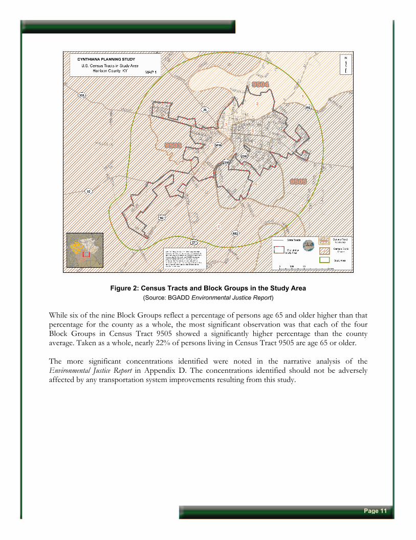
Figure 2: Census Tracts and Block Groups in the Study Area (Source: BGADD Environmental Justice Report)
While six of the nine Block Groups reflect a percentage of persons age 65 and older higher than that percentage for the county as a whole, the most significant observation was that each of the four Block Groups in Census Tract 9505 showed a significantly higher percentage than the county average. Taken as a whole, nearly 22% of persons living in Census Tract 9505 are age 65 or older. The more significant concentrations identified were noted in the narrative analysis of the Environmental Justice Report in Appendix D. The concentrations identified should not be adversely affected by any transportation system improvements resulting from this study.
Page 11
5.0 RECOMMENDATIONS
Following the first Advisory Committee meeting and receipt of the public input, the project team took into account all of the available project information. The team then identified alternatives to be carried forward or eliminated from further consideration. The criteria that were considered in the decision included the project ease of implementation, costs, impacts, traffic volumes, and public comments.
In determining the alternatives to be carried forward, the project team first separated the recommended projects into three categories based on project origination and party responsibility. The categories are as follows:
KYTC Short-Term—Projects that can be executed fairly quickly by the District personnel focusing on low cost operational and safety improvements. These projects typically range in cost from <$10,000 - $200,000. These projects are listed in Table 3A and one page descriptions of each are included on summary sheets, pages 22 to 36.
KYTC Long-Term—Projects of the scale that would likely have to be included in the Highway Plan. These projects are listed in Table 3B and one page descriptions of each are included on summary sheets, pages 37 to 47.
Local—Projects that would be the responsibility of the City of Cynthiana, Harrison County, and/or private developers and that may be undertaken at the discretion of any of those entities. These projects are listed in Table 3C and one page descriptions of each are included on summary sheets, pages 48 to 66.
The projects recommended by the Advisory Committee and project team (i.e., those identified on Tables 3A through 3C and described in the summary sheets) are illustrated in Exhibit 4 in Appendix A.
Page 12
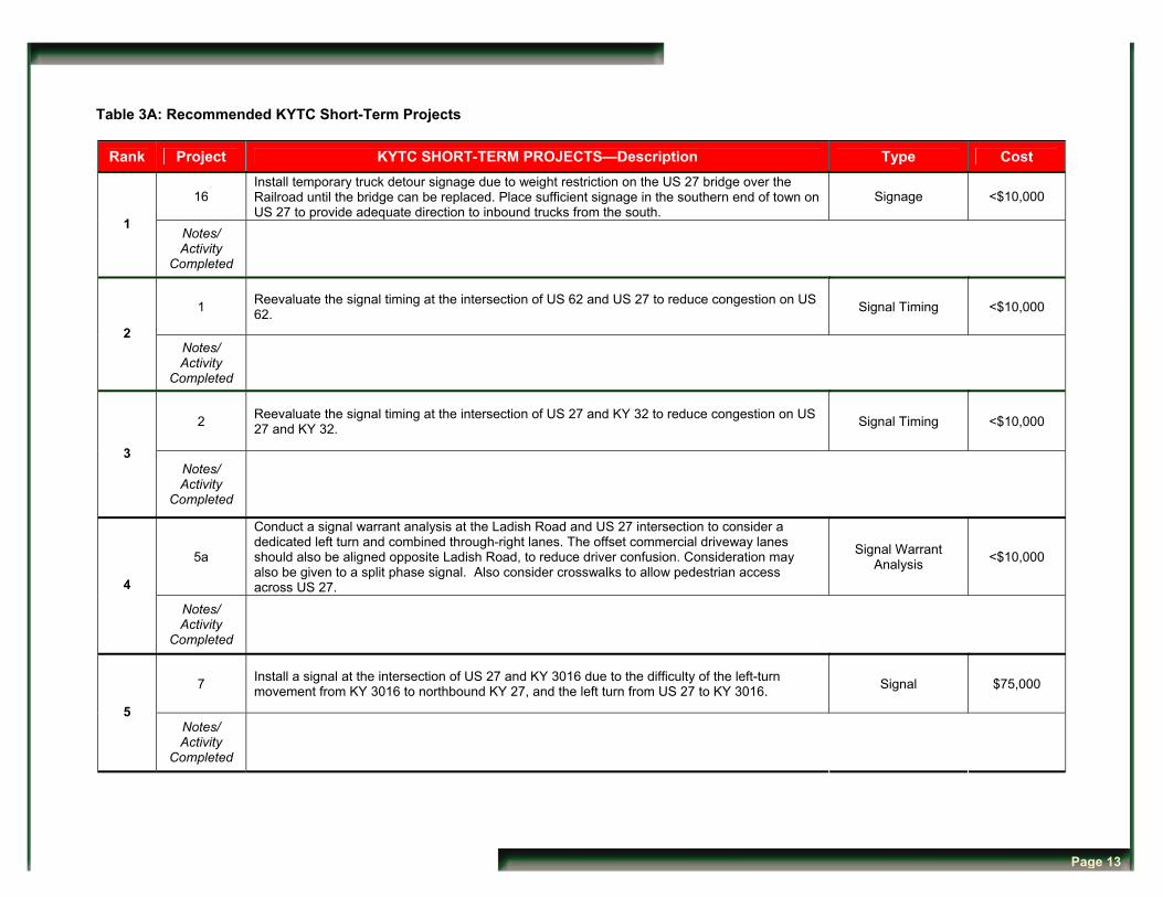
Table 3A: Recommended KYTC Short-Term Projects
Rank Project KYTC SHORT-TERM PROJECTS—Description Type Cost
16 Install temporary truck detour signage due to weight restriction on the US 27 bridge over the Railroad until the bridge can be replaced. Place sufficient signage in the southern end of town on US 27 to provide adequate direction to inbound trucks from the south.
Signage <$10,000
1 Notes/ Activity
Completed
1 Reevaluate the signal timing at the intersection of US 62 and US 27 to reduce congestion on US 62. Signal Timing <$10,000
2 Notes/ Activity
Completed
2 Reevaluate the signal timing at the intersection of US 27 and KY 32 to reduce congestion on US 27 and KY 32. Signal Timing <$10,000
3 Notes/ Activity
Completed
5a
Conduct a signal warrant analysis at the Ladish Road and US 27 intersection to consider a dedicated left turn and combined through-right lanes. The offset commercial driveway lanes should also be aligned opposite Ladish Road, to reduce driver confusion. Consideration may also be given to a split phase signal. Also consider crosswalks to allow pedestrian access across US 27.
Signal Warrant Analysis <$10,000
4
Notes/ Activity
Completed
7 Install a signal at the intersection of US 27 and KY 3016 due to the difficulty of the left-turn movement from KY 3016 to northbound KY 27, and the left turn from US 27 to KY 3016. Signal $75,000
5 Notes/ Activity
Completed
Page 13

Table 3A: Recommended KYTC Short -Term Projects (continued)
Rank Project KYTC SHORT-TERM PROJECTS—Description Type Cost
11 Construct a left-turn lane on Main Street (US 27) at West Pleasant Street (KY 356). This will require an analysis for a split phase signal and possible restriping on US 27.
Reconstruction/ Signal Analysis $75,000
6 Notes/ Activity
Completed
40 Due to congestion, conduct intersection signal timing analysis on downtown streets to verify most efficient performance. This project requires local initiation as a request to KYTC. Signal Analysis <$10,000
7 Notes/ Activity
Completed
13 Address sidewalk deterioration on the W. Pleasant Street (KY 356) bridge to improve safety for pedestrians. Maintenance <$10,000
8 Notes/ Activity
Completed
10 Relocate the street signage at the intersection of Main Street (US 27) and Pike Street (KY 32) to a more visible location to reduce driver confusion. Signage <$10,000
9 Notes/ Activity
Completed
4 Decrease embankment elevation on the west side of intersection and remove the tree on the east side of the intersection to improve the sight distance for traffic entering KY 356 from Spruce Drive.
Maintenance <$10,000
10 Notes/ Activity
Completed
Page 14
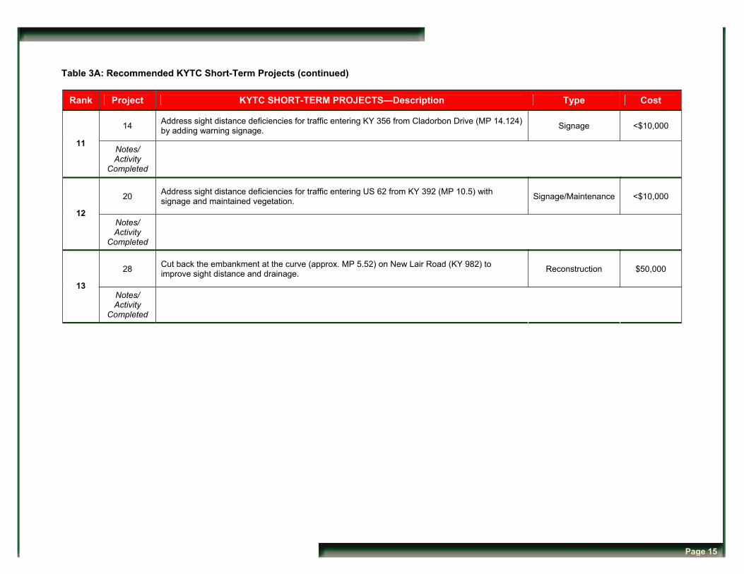
Table 3A: Recommended KYTC Short-Term Projects (continued)
Rank Project KYTC SHORT-TERM PROJECTS—Description Type Cost
14 Address sight distance deficiencies for traffic entering KY 356 from Cladorbon Drive (MP 14.124) by adding warning signage. Signage <$10,000
11 Notes/ Activity
Completed
20 Address sight distance deficiencies for traffic entering US 62 from KY 392 (MP 10.5) with signage and maintained vegetation. Signage/Maintenance <$10,000
12 Notes/ Activity
Completed
28 Cut back the embankment at the curve (approx. MP 5.52) on New Lair Road (KY 982) to improve sight distance and drainage. Reconstruction $50,000
13 Notes/ Activity
Completed
Page 15
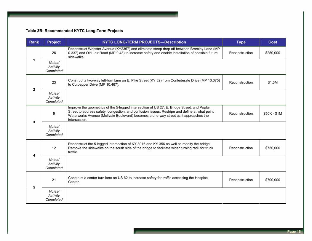
Table 3B: Recommended KYTC Long-Term Projects
Rank Project KYTC LONG-TERM PROJECTS—Description Type Cost
26 Reconstruct Webster Avenue (KY2357) and eliminate steep drop off between Bromley Lane (MP 0.337) and Old Lair Road (MP 0.43) to increase safety and enable installation of possible future sidewalks.
Reconstruction $250,000
1 Notes/ Activity
Completed
23 Construct a two-way left-turn lane on E. Pike Street (KY 32) from Confederate Drive (MP 10.075) to Culpepper Drive (MP 10.467). Reconstruction $1.3M
2 Notes/ Activity
Completed
9
Improve the geometrics of the 5-legged intersection of US 27, E. Bridge Street, and Poplar Street to address safety, congestion, and confusion issues. Restripe and define at what point Waterworks Avenue (McIlvain Boulevard) becomes a one-way street as it approaches the intersection.
Reconstruction $50K - $1M
3 Notes/ Activity
Completed
12 Reconstruct the 5-legged intersection of KY 3016 and KY 356 as well as modify the bridge. Remove the sidewalks on the south side of the bridge to facilitate wider turning radii for truck traffic.
Reconstruction $750,000
4 Notes/ Activity
Completed
21 Construct a center turn lane on US 62 to increase safety for traffic accessing the Hospice Center. Reconstruction $700,000
5 Notes/ Activity
Completed
Page 16
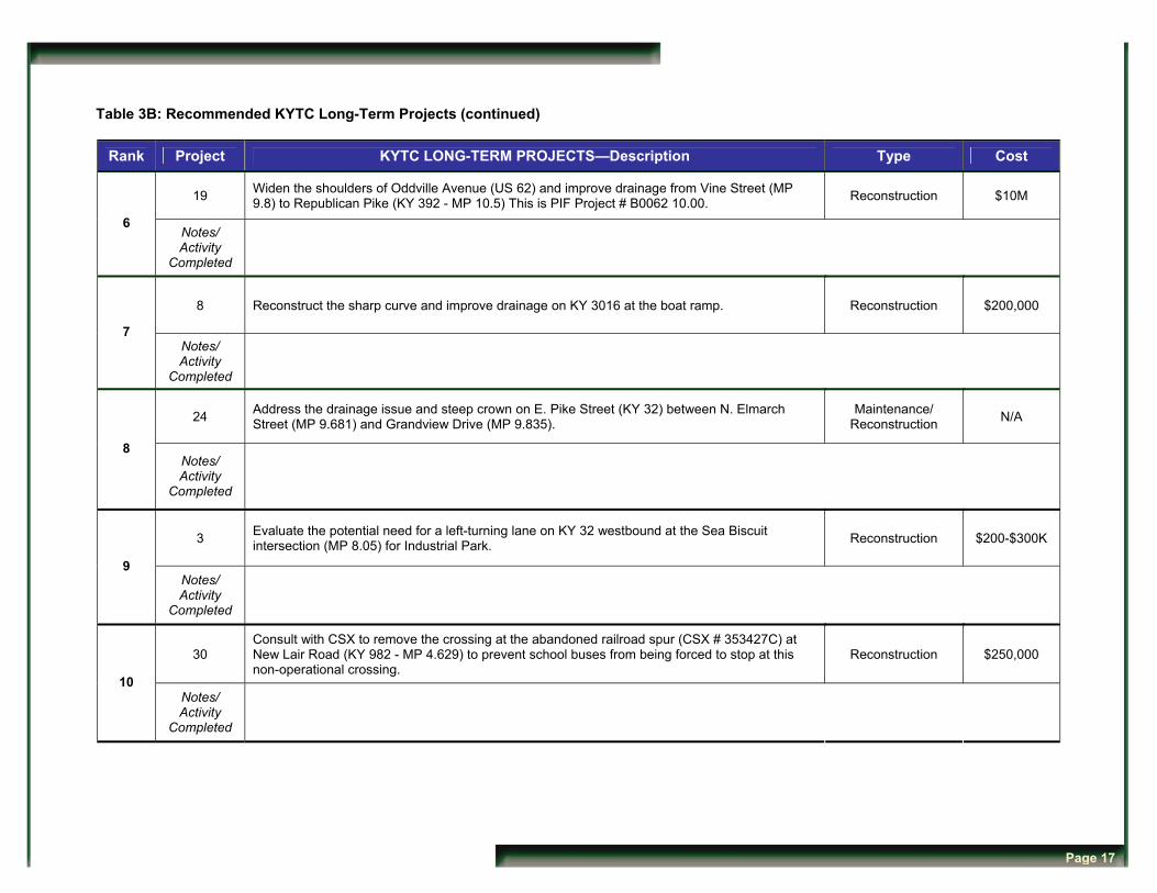
Table 3B: Recommended KYTC Long-Term Projects (continued)
Rank Project KYTC LONG-TERM PROJECTS—Description Type Cost
19 Widen the shoulders of Oddville Avenue (US 62) and improve drainage from Vine Street (MP 9.8) to Republican Pike (KY 392 - MP 10.5) This is PIF Project # B0062 10.00. Reconstruction $10M
6 Notes/ Activity
Completed
8 Reconstruct the sharp curve and improve drainage on KY 3016 at the boat ramp. Reconstruction $200,000
7 Notes/ Activity
Completed
24 Address the drainage issue and steep crown on E. Pike Street (KY 32) between N. Elmarch Street (MP 9.681) and Grandview Drive (MP 9.835).
Maintenance/ Reconstruction N/A
8 Notes/ Activity
Completed
3 Evaluate the potential need for a left-turning lane on KY 32 westbound at the Sea Biscuit intersection (MP 8.05) for Industrial Park. Reconstruction $200-$300K
9 Notes/ Activity
Completed
30 Consult with CSX to remove the crossing at the abandoned railroad spur (CSX # 353427C) at New Lair Road (KY 982 - MP 4.629) to prevent school buses from being forced to stop at this non-operational crossing.
Reconstruction $250,000
10 Notes/ Activity
Completed
Page 17

Table 3C: Recommended Local Projects
Rank Project LOCAL PROJECTS—Description Type Cost
44 As a safety measure for pedestrians, rebuild the chain link fence on the Webster Avenue bridge. This project is of the highest priority among the Local projects. Maintenance <$10,000
High Notes/ Activity
Completed
43
Conduct and adopt a traffic management/flow plan for the school campus area surrounding Webster Avenue and the Education Drive Area. This study may be combined with Local projects 27 and 29 at the discretion of the City/Board of Education. This project is of the second highest priority among the Local projects.
Traffic Management Study TBD
High Notes/ Activity
Completed
18 Due to poor sight distance, install signage for the Harrison County Health Department on Oddville Avenue (US 62). Signage <$10,000
High Notes/ Activity
Completed
27 Implement traffic management system such as flashing beacon to regulate the undefined nature of the intersection of Webster Avenue and Education Drive Signage/Beacon $25,000
High Notes/ Activity
Completed
29
Local jurisdiction request to KYTC to conduct a signal warrant analysis at the intersection of Webster Avenue (KY 2357) and New Lair Road (KY 982) to mitigate poor sight distance, possibly via flashing light/beacon. Also evaluate a flashing pedestrian warning sign at the school crosswalk across Webster Avenue.
Signal Warrant Analysis <$10,000
High Notes/ Activity
Completed
Page 18
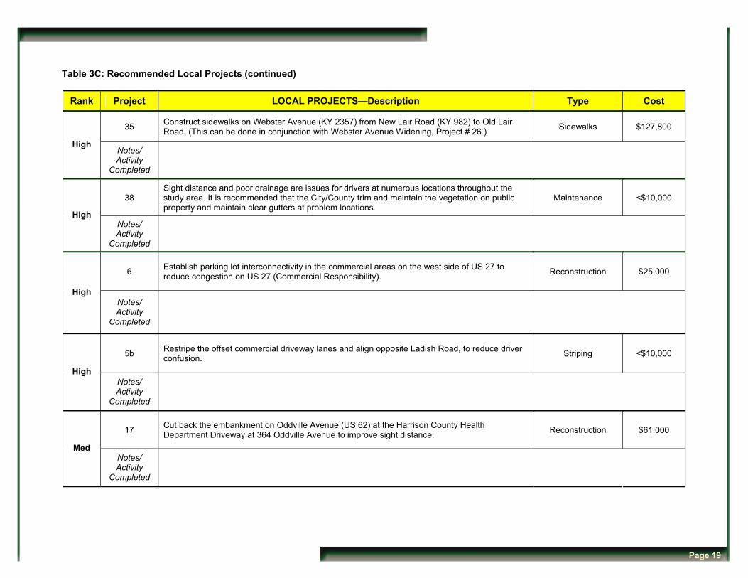
Table 3C: Recommended Local Projects (continued)
Rank Project LOCAL PROJECTS—Description Type Cost
35 Construct sidewalks on Webster Avenue (KY 2357) from New Lair Road (KY 982) to Old Lair Road. (This can be done in conjunction with Webster Avenue Widening, Project # 26.) Sidewalks $127,800
High Notes/ Activity
Completed
38 Sight distance and poor drainage are issues for drivers at numerous locations throughout the study area. It is recommended that the City/County trim and maintain the vegetation on public property and maintain clear gutters at problem locations.
Maintenance <$10,000
High Notes/ Activity
Completed
6 Establish parking lot interconnectivity in the commercial areas on the west side of US 27 to reduce congestion on US 27 (Commercial Responsibility). Reconstruction $25,000
High Notes/ Activity
Completed
5b Restripe the offset commercial driveway lanes and align opposite Ladish Road, to reduce driver confusion. Striping <$10,000
High Notes/ Activity
Completed
17 Cut back the embankment on Oddville Avenue (US 62) at the Harrison County Health Department Driveway at 364 Oddville Avenue to improve sight distance. Reconstruction $61,000
Med Notes/ Activity
Completed
Page 19
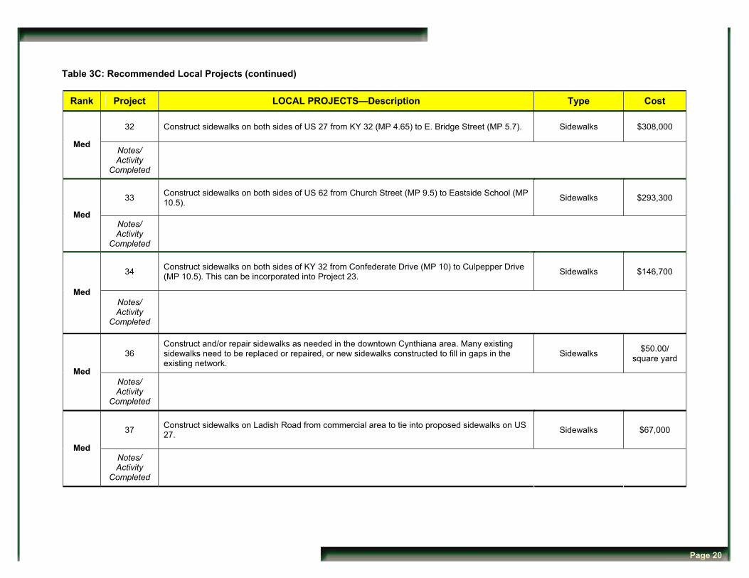
Table 3C: Recommended Local Projects (continued)
Rank Project LOCAL PROJECTS—Description Type Cost
32 Construct sidewalks on both sides of US 27 from KY 32 (MP 4.65) to E. Bridge Street (MP 5.7). Sidewalks $308,000
Med Notes/ Activity
Completed
33 Construct sidewalks on both sides of US 62 from Church Street (MP 9.5) to Eastside School (MP 10.5). Sidewalks $293,300
Med Notes/ Activity
Completed
34 Construct sidewalks on both sides of KY 32 from Confederate Drive (MP 10) to Culpepper Drive (MP 10.5). This can be incorporated into Project 23. Sidewalks $146,700
Med Notes/ Activity
Completed
36 Construct and/or repair sidewalks as needed in the downtown Cynthiana area. Many existing sidewalks need to be replaced or repaired, or new sidewalks constructed to fill in gaps in the existing network.
Sidewalks $50.00/ square yard
Med Notes/ Activity
Completed
37 Construct sidewalks on Ladish Road from commercial area to tie into proposed sidewalks on US 27. Sidewalks $67,000
Med Notes/ Activity
Completed
Page 20
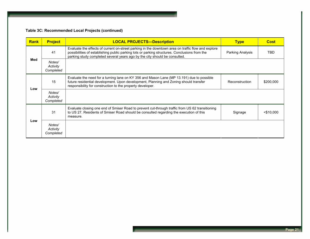
Table 3C: Recommended Local Projects (continued)
Rank Project LOCAL PROJECTS—Description Type Cost
41 Evaluate the effects of current on-street parking in the downtown area on traffic flow and explore possibilities of establishing public parking lots or parking structures. Conclusions from the parking study completed several years ago by the city should be consulted.
Parking Analysis TBD
Med Notes/ Activity
Completed
15 Evaluate the need for a turning lane on KY 356 and Mason Lane (MP 13.191) due to possible future residential development. Upon development, Planning and Zoning should transfer responsibility for construction to the property developer.
Reconstruction $200,000
Low Notes/ Activity
Completed
31 Evaluate closing one end of Smiser Road to prevent cut-through traffic from US 62 transitioning to US 27. Residents of Smiser Road should be consulted regarding the execution of this measure.
Signage <$10,000
Low Notes/ Activity
Completed
Page 21