New Jersey Coastal Management Program Section 309 ...
195
New Jersey Department of Environmental Protection Office of Policy and Coastal Management 401 East State Street P.O. Box 420, Mail Code 401-07B Trenton, New Jersey 08625-0420 New Jersey Coastal Management Program Section 309 Assessment and Strategy 2021-2025
Transcript of New Jersey Coastal Management Program Section 309 ...

New Jersey Department of Environmental Protection Office of Policy and Coastal Management
401 East State Street P.O. Box 420, Mail Code 401-07B Trenton, New Jersey 08625-0420
New Jersey Coastal Management Program Section 309 Assessment and Strategy
2021-2025
Table of Contents
I. Introduction 4
New Jersey Coastal Management Program 4
About the Section 309 Enhancement Program 6
II. Summary of Recent Section 309 Achievements 8
Aquaculture 8
Coastal Hazards and Cumulative and Secondary Impacts Integrated Strategy 9
Oceans and Great Lakes Resources 10
Wetlands 12
III. Enhancement Area Assessments 15
Phase I (High-Level) Assessments 15
Wetlands 16
Coastal Hazards 28
Public Access 42
Marine Debris 52
Cumulative and Secondary Impacts 58
Special Area Management Planning 71
Ocean and Great Lakes Resources 75
Energy and Government Facility Siting 82
Aquaculture 90
Phase II (In-Depth) Assessments 100
Wetlands 101
Coastal Hazards 111
Public Access 120
Oceans and Great Lakes Resources 126
IV. Strategies 134
Wetlands Strategy 135
Coastal Hazards Strategy 143
Public Access Strategy 150
Oceans and Great Lakes Resources Strategy 157

V. Summary of Stakeholder and Public Comment 165
Stakeholder Engagement 165
Public Comment 168
Appendix A – External Stakeholders 171
Appendix B – External Stakeholders Survey Response Summary 177
Coastal Wetlands 177
Coastal Hazards 179
Public Access 181
Marine Debris 183
Cumulative and Secondary Impacts 185
Special Area Management Plans (SAMPs) 187
Ocean Resources 188
Energy and Government Facility Siting 191
Aquaculture 194

4
I. Introduction
New Jersey Coastal Management Program The Coastal Zone Management Act (CZMA) of 1972 authorized the National Coastal Zone Management Program, which is a voluntary partnership between the federal government and U.S. coastal and Great Lakes states and territories. The purpose of the program is to balance the protection of coastal resources with the many competing uses of coastal areas. The CZMA encourages coastal states to be proactive in managing coastal resources for their benefit and the benefit of the nation. The program is currently administered by the National Atmospheric and Oceanic Administration (NOAA). New Jersey’s Coastal Management Program (NJCMP) received federal approval in 1978. Through the NJCMP, the New Jersey Department of Environmental Protection (NJDEP) manages the state's diverse coastal zone, which encompasses tidal and non-tidal waters, waterfronts, and inland areas, including portions of 17 counties and 239 municipalities. The coastal zone incorporates the Hudson River, from the interstate border with New York, and its related tidal waters before continuing south to and along the Raritan Bay. From the bay, the coastal zone extends from Sandy Hook to Cape May Point, encompassing the state territorial waters of the Atlantic Ocean and associated tidal water bodies. From Cape May Point, the coastal zone trends north to Trenton and contains waters of the Delaware Bay and River, including tidal portions of their tributaries. Upland areas along these tidal waterways are included within the coastal zone. In total, New Jersey’s coastal zone boundary encompasses approximately 1,800 miles of tidal coastline, including 126 miles along the Atlantic oceanfront from Sandy Hook to Cape May.
5
To effectively manage the coastal zone, the NJCMP is comprised of a network of offices within NJDEP that share responsibility for managing New Jersey’s coastal uses and resources. The Land Use Management Program’s Office of Policy and Coastal Management (OPCM) administers the NJCMP. OPCM is also responsible for the preparation and submission of all program changes related to the NJCMP and reports on Coastal Zone Management grants. OPCM coordinates with local governments and other organizations and programs that have interests and initiatives in the coastal area as well as with the coastal programs of adjacent states and provides technical advice to other NJDEP programs regarding existing coastal resource management policies. In addition, OPCM develops and promulgates the rules and regulations implementing the Coastal Area Facility Review Act (CAFRA), the Waterfront Development Law, the Wetlands Act of 1970, the Freshwater Wetlands Protection Act, and the Flood Hazard Area Control Act. These rules include the Coastal Zone Management (CZM) Rules, N.J.A.C. 7:7; the Freshwater Wetlands Protection Act (FWPA) Rules, N.J.A.C. 7:7A; and the Flood Hazard Area Control Act (FHACA) Rules, N.J.A.C. 7:13. OPCM also conducts education and outreach, including stakeholder outreach, for the NJCMP and coordinates all Federal consistency reviews.
The Division of Land Use Regulation (DLUR), which is also under the Land Use Management program, reviews coastal permit applications submitted to the NJDEP under the CZM Rules as well as permit applications submitted under the FWPA and FHACA Rules. DLUR is also responsible for conducting Federal consistency reviews. The Office of Dredging and Sediment Technology, which is part of DLUR, is responsible for reviewing dredging and port development projects. The Bureau of Tidelands Management, also part of DLUR, serves as staff for the Tidelands Resource Council, a governor-appointed, autonomous body with jurisdiction over State-owned tidelands. Where needed, other NJDEP offices outside of Land Use Management, such as the Division of Science and Research (DSR), the Natural and Historic Resources Division of Fish and Wildlife (DFW), Division of Parks and Forestry (DPF), and Historic Preservation Office (HPO), provide technical assistance for DLUR. The Bureau of Climate Resilience Planning (BCRP) provides planning and technical support to New Jersey’s communities to help them make informed decisions about climate resilience. BCRP is responsible for coordinating NJDEP’s policies, programs, and activities to plan for the impacts and the associated hazards of climate change and for promoting public awareness of climate change science. The Division of Coastal Engineering manages the Aids to Navigation program, coastal area dredging, and shore protection projects, including beach replenishment, bulkhead installation, and groin modification. Coastal Engineering also participates with the United States Army Corps of Engineers (USACE) on all USACE-sponsored shore protection projects in New Jersey. The Bureau of Coastal and Land Use Enforcement (CLUE) investigates possible coastal and freshwater wetland violations and seeks remedies for violations. CLUE is also responsible for ensuring compliance with coastal, freshwater wetlands, and flood hazard area permits issued for projects throughout the coastal area. The Division of Water Monitoring and Standards provides water quality information to assess
6
and manage New Jersey's water resources. The Division is responsible for river/lake/ground water monitoring, beach/bay/ocean monitoring, water quality standards and assessments, TMDLs, restoration projects, and citizen science. The DSR provides the NJDEP and the NJCMP with scientific and technical information and expertise to support its policy needs and to ensure decisions are based upon the best possible scientific and technical information. The DSR performs research to meet the information and problem-solving needs, identifies and understands emerging issues that require the NJDEP’s attention, and advocates/integrates the multi-disciplinary perspective into the NJDEP’s identification, analysis, and resolution of environmental issues. The Division of Parks and Forestry, Office of Natural Lands Management (ONLM) provides information on wetland monitoring and classification as well as rare species data in support of NJDEP rules and regulations. The Biotics database, a platform shared by the DPF and the DFW, contains data and maps on rare plants, rare animals, and rare ecological communities. Data requests for all rare species related to DLUR permitting is handled through the ONLM. The New Jersey Green Acres Program, established to address New Jersey's growing recreation and conservation needs, focuses primarily on the acquisition of land, linking existing protected areas to create open space corridors that provide valuable contiguous linear habitat to facilitate movement of wildlife, rare plants, and ecological communities as well as parkland for recreation and areas of scenic benefit between towns and urban centers. Many of these lands are in the coastal zone. In addition, the Coastal Blue Acres Program, created with the passage of the Green Acres, Farmland, Historic Preservation and Blue Acres Bond Act of 1995, provides grants and loans to municipalities and counties to acquire coastal lands that are storm damaged, prone to storm damage, or protecting other lands from storm damage in order to repurpose these lands for recreation and conservation.
About the Section 309 Enhancement Program The Coastal Zone Enhancement Program was established in 1990 under Section 309 of the amended Coastal Zone Management Act. The enhancement program encourages states and territories to strengthen and improve their federally approved Coastal Management Programs (CMPs) in one or more of nine areas. These “enhancement areas” include wetlands, coastal hazards, public access, marine debris, cumulative and secondary impacts, special area management plans, ocean and Great Lakes resources, energy and government facility siting, and aquaculture. Every five years, states and territories are encouraged to conduct self-assessments of their CMPs to determine problems and opportunities for improvement within each of the nine enhancement areas and to assess the effectiveness of existing coastal management efforts to address identified problems. Each CMP identifies high priority coastal management issues as well as important needs and information gaps the program must fill to address these issues. Following this self-assessment, NOAA’s Office for Coastal Management (OCM) works closely
7
with each CMP to further identify the high priority needs for improvement within one or more of the nine areas. Consulting with OCM, the CMP then develops strategies to improve its operations to address these coastal management needs. The strategies provide a step-by-step approach to reach a stated goal, leading to an enhancement to the CMP. OCM reviews the Section 309 assessment and strategy document for each state and territory and, if approved, provides funding under Section 309 to help execute the strategies identified in the document. Development of the Section 309 Assessment and Strategy Internal and external stakeholders were engaged in the development of this Section 309 Assessment and Strategy document through a series of stakeholder meetings as well as a stakeholder survey, which are described in more detail in the Summary of Stakeholder and Public Comment section of this document. Appendix A provides a list of the stakeholders who were invited to participate. The stakeholders provided feedback regarding priority enhancement areas for the state’s coastal zone, the critical problems related to those priority areas, and the greatest opportunities for the NJCMP to strengthen and enhance its program to more effectively address those problems, which were taken into consideration during the development of the NJCMP’s assessments and strategies. Public participation in the assessment and strategy process was also provided through review and comment on this draft document.
8
II. Summary of Recent Section 309 Achievements This section provides a brief summary of select accomplishments completed under the Section 309 Program since the last assessment and strategy. The Section 309 strategies developed in 2016 sought to enhance the management of aquaculture, coastal hazards and cumulative and secondary impacts, oceans and Great Lakes resources, and wetlands.
Aquaculture New Jersey’s 2016-2020 aquaculture strategy included the adoption of regulatory amendments and revised guidelines to streamline the permitting process, protect shorebird habitat, and designate new aquaculture use areas. Specifically, the NJCMP proposed to continue coordination between federal and state agencies, the aquaculture industry, New Jersey Shellfisheries Council, the Shellfish Aquaculture Working Group, and the Aquaculture Advisory Council to refine the CZM Rules addressing shellfish aquaculture to appropriately balance the needs of the industry with the NJCMP’s mission. The NJCMP also proposed to update data and spatial mapping of special areas, specifically special water and special water’s edge areas, to improve siting of aquaculture facilities from both an industry and coastal resource protection perspective. Regulatory Amendments On July 17, 2017, the Department proposed amendments, repeals, and new rules to the CZM Rules in response to issues identified through stakeholder outreach and to address other issues that arose following the July 6, 2015 adoption of the consolidated coastal rules. The proposed amendments included amendments related to shellfish aquaculture. Public hearings were held on August 10, 2017 and August 15, 2017. The comment period on the proposal closed September 15, 2017. The Department received a number of comments on these proposed amendments, highlighting that further input from stakeholders was needed to ensure that any changes achieved the desired environmental protection without having unintended consequences. As a result of the comments received, the proposed amendments relating to shellfish aquaculture were not adopted. However, NJDEP is still working towards regulatory changes and continues to participate in public, private, and nonprofit coordination efforts and assessments of potential industry impacts on threatened species. It should be noted that the NJCMP does not have authority over all regulations pertaining to aquaculture. NJCMP staff from OPCM and DLUR currently participate in the Shellfish Aquaculture Working Group (SAWG), which is an interagency working group focused on coordinating the regulation of aquaculture in New Jersey. The SAWG consists of representatives from the NJDEP’s Bureau of Shellfisheries, Bureau of Marine Water Monitoring, Division of Land Use Regulation, Bureau of Tidelands Management, Office of Policy and Coastal Management, Bureau of Coastal and Land Use Compliance and Enforcement, and Division of Fish and Wildlife and Marine Enforcement; the New Jersey Department of Agriculture; New Jersey Department of Health; United States Army Corps of Engineers; and the
9
Food and Drug Administration. OPCM staff serve as the SAWG chair and also chair both the Regulatory Issues and Permitting Guidance Document committees. Shellfish and SAV Habitat Mapping Under contract with the NJCMP, Stockton University completed a pilot project for the development of a remote mapping methodology that can be used to create GIS mapping of suitable habitats for submerged aquatic vegetation (SAV) and suitable shellfish habitat areas within the state’s coastal waters. The NJCMP also began a project to map the NJDEP Marine Fisheries Administration subaqueous sediment, shellfish population, shellfish lease areas, hard clam population, and other field data to migrate this information into public GIS Layers. This data is important reference information for reviewing and analyzing coastal development, living shoreline restoration projects, and coastal regulations. In addition, staff from Land Use Management met with the Bureau of Shellfisheries, the DSR, and NJDEP data experts to review historical data housed at the Bureau of Shellfisheries office in Nacote Creek to determine appropriate data to be mined from paper files to databases and GIS mapping. The information housed in the paper files is currently the basis for regulatory decisions and needs to be organized, updated, and made publicly available for greater efficiency and transparency. The intent of this effort was that it would eventually lead to contracting with an external entity to organize and create a database for this historical shellfisheries data.
Coastal Hazards and Cumulative and Secondary Impacts Integrated Strategy For 2016-2020, the NJCMP developed an integrated strategy for the coastal hazards and the cumulative and secondary impacts enhancement areas. For this strategy, the NJCMP proposed to develop a Sustainable and Resilient Coastal Communities (SRCC) program representing a balanced process and guidelines to inform local land use planning by encouraging sustainable economic growth, protecting coastal resources, and minimizing risks of coastal hazards. The strategy also included establishing methodologies for updating maps of certain coastal resources and the NJCMP’s special areas and initiating these mapping updates. The updated maps were to be used as a resource for working with selected communities to pilot and evaluate the SRCC planning program. This information was to result in development of new guidelines, policies, and best management practices, as well as implementation of strategies, that reduce cumulative impacts, risk, and vulnerability to coastal hazards. Sustainable and Resilient Coastal Communities Program The NJCMP’s intent with this strategy was to evaluate existing resiliency planning tools and programs, such as the Coastal Vulnerability Index, Coastal Vulnerability Assessment, Getting to Resilience, Sustainable + Resilient Coastal Communities project, NJ FRAMES, Resilient NJ, Engineering Guidelines for Living Shorelines, and Building Ecological Solutions to Coastal Community Hazards Guide, and to utilize them to build a comprehensive planning program that addresses both coastal hazards and cumulative and secondary impacts at a regional scale.
10
However, during the implementation of these programs, the NJCMP learned that without additional state funding, the funds provided by New Jersey’s annual Coastal Zone Management grant are insufficient to support a comprehensive program while continuing to fund other activities in the grant. The NJCMP also learned that coastal communities now prefer to focus on implementation rather than planning. These conclusions were summarized in a white paper, which was a major milestone included under the 2016-2020 coastal hazards and cumulative and secondary impacts integrated strategy. In lieu of an SRCC comprehensive planning program, the white paper recommended piloting a Sustainable & Resilient Coastal Communities local grant program that would assist communities with the implementation of planning and policy development activities. This local grant program prioritizes development of local policy and planning actions required for State Plan Endorsement or implementation of policy and planning actions proposed by local governments in their Local Resilience Strategy and Implementation Plans. Policy and planning actions identified under other resilience planning projects of the NJCMP (e.g. S&RCC and NJ FRAMES) are also eligible for the grant program. The NJCMP is piloting this grant program during the Year 39 CZM grant period (October 2019-March 2021). Mapping Updates The NJCMP began reviewing the feasibility of mapping Coastal Zone Management Rule special areas. The 47 identified special areas are specific features of New Jersey’s coastal environment that the State has determined may be adversely affected by regulated activities or may require the application of specific management protocols or restrictions to ensure their integrity. Partnering with Jacques Cousteau National Estuarine Research Reserve (JCNERR), NJCMP staff began actively researching and identifying critical data sets and cultivating appropriate outside resources to close existing data gaps. Spatial mapping has been acquired for about half of the designated special areas and data development has begun, focused upon developing suitable spatial datasets that depict, where data is available, the spatial extent of a designated special area. Where NJDEP does not have spatial data, program staff is working with JCNERR to discover other spatial mapping sources that may be suitable for mapping the special areas.
Oceans and Great Lakes Resources The NJCMP’s 2016-2020 strategy included working with partners to advance the objectives of the Mid-Atlantic Regional Council on the Ocean and developing an Ocean Action Plan for the Mid-Atlantic Regional Planning Body. The strategy also included defining New Jersey-specific ocean resource objectives, seeking to ensure those objectives were addressed in regional planning efforts, and augmenting existing data on New Jersey ocean resources and potential siting of uses. The strategy was to result in development and execution of Memoranda of Agreement (MOAs) or other documents establishing improved planning and management processes with applicable agencies. Improving Interjurisdictional Coordination and Decision-making
The Mid-Atlantic Regional Council on the Ocean (MARCO) was created by the governors of New York, New Jersey, Delaware, Maryland, and Virginia in June 2009. The agreement between
11
the states established guiding principles as the foundation for collaboration and four initial priorities for shared action:
1. Coordinate protection of important habitats and sensitive and unique offshore areas on a regional scale;
2. Promote improvements in the region’s coastal water quality;
3. Collaborate on a regional approach to support the sustainable development of renewable energy in offshore areas; and
4. Prepare the region’s coastal communities for the impacts of climate change on ocean and coastal resources.
The participating states developed an action plan entitled “Actions, Timelines, and Leadership to Advance the Mid-Atlantic Governors’ Agreement on Ocean Conservation” that includes a problem statement for each of the four priorities as well as goals, objectives, and initial actions towards meeting those goals.
In 2010, Presidential Executive Order 13547 established a National Ocean Policy (NOP) to guide the protection, maintenance, and restoration of America’s oceans and coasts, which called for the creation of Regional Planning Bodies (RPBs) to coordinate and implement regional ocean planning with state, federal, tribal, and fishery management council representatives. The Mid-Atlantic RPB began developing an Ocean Action Plan in 2013 that established eleven overarching principles to guide ocean planning, two goals for the regional ocean planning process (healthy ocean ecosystems and sustainable ocean uses), and a series of objectives related to each goal. With the finalization of the Ocean Action Plan in December 2016, the RPB entered the implementation phase for almost 40 actions through the formation of workgroups across the various objectives under the two goals.
However, on June 19, 2018, President Trump revoked the RPBs through Executive Order 13840. Despite this, MARCO, as the regional ocean partnership for the mid-Atlantic, continues to work on issues outlined through the RPB and the Ocean Action Plan as many of these issues are priorities for the MARCO states. In 2019, to engage the diverse interests in the region and enhance the vitality of the region’s ocean ecosystem and economy, the MARCO states and a partnership of federal agencies, tribal entities, and the Mid-Atlantic Fishery Management Council formed the Mid-Atlantic Committee on the Ocean (MACO). MACO will coordinate across the region on ocean and coastal issues. NJCMP staff currently serve as MACO’s chair. Addressing New Jersey-specific Ocean Resource and Use Interests in MARCO and Mid-Atlantic RPB Regional Ocean Planning Efforts NJCMP staff serve on MARCO’s Ocean Data and Mapping Team, which is responsible for the identification of data needs across the region as well as information updates and revisions to the Data Mapping Portal. New Jersey has provided updated mapping for New Jersey-specific recreational fishing grounds and is working to ensure that continual updates are made to the

12
portal’s commercial fisheries data, which is vital to New Jersey’s coastal zone. Data related to offshore wind energy development is also updated on a continuous basis. New Jersey is also working with other MARCO states and federal agencies through MACO to identify new workgroups related to sand management and regional resiliency to ensure New Jersey’s interests are considered in these endeavors. Collection of Ocean Resource and Use Data In addition to serving on the Ocean Data and Mapping Team to identify data needs and assist in updating information in MARCO’s Data Mapping Portal, the NJCMP has been researching submerged electric transmission cables, installation techniques, and their possible impacts. Sustainable development of offshore wind energy is a priority for New Jersey and ensuring compatibility with other existing uses, such as commercial fishing, is critical in protecting the New Jersey coastal zone. Development and Execution of MOAs or Other Documents Establishing Improved Processes with Applicable Agencies Following the creation of the Mid-Atlantic RPB in 2013, the RPB developed a charter that describes its purpose, participants, and a preliminary delineation of roles and responsibilities for the members as they engaged in regional marine planning. As signatories to the charter, the members formalized their commitments to the principles of regional marine planning and to working constructively and cooperatively toward their identified regional goals and objectives. The Mid-Atlantic RPB also developed a framework that informs the regional ocean planning process by articulating a vision, principles, goals, objectives, example actions, and geographic focus. This framework guided the development of an RPB workplan and RPB products. As mentioned above, the Mid-Atlantic RPB began developing an Ocean Action Plan that established eleven overarching principles to guide ocean planning, two goals for the regional ocean planning process (healthy ocean ecosystems and sustainable ocean uses), and a series of objectives related to each goal. Although President Trump revoked the RPBs through Executive Order 13840, MARCO continues to work on issues outlined through the RPB and the Ocean Action Plan, and MACO was formed in 2019 to engage the diverse interests in the region and enhance the vitality of the region’s ocean ecosystem and economy. MACO will continue the coordination and collaboration across the region on ocean and coastal issues established under the National Ocean Policy (NOP), which originally called for the creation of the RPBs to coordinate and implement regional ocean planning.
Wetlands The NJCMP’s 2016-2020 strategy included supporting expanded and effective use of ecologically based mitigation strategies. NJDEP planned to facilitate ecologically based hazard mitigation strategies through advocacy and technical assistance to communities with design, implementation, and permitting for shoreline/wetland restoration projects, including living shorelines. NJDEP was also to monitor and assess the efficacy of ecologically based mitigation
13
efforts by researching and monitoring pilot projects and creation of project metrics. These efforts were intended to lead to adopting a living shoreline program and recommended changes to related New Jersey programs and regulations. Research and Assessment The NJCMP acquired a Phantom 4 Pro small unmanned aircraft system (drone) to provide visual monitoring and assessment data of Living Shoreline projects, shorelines, coastal wetlands, and storm damage. Aerial documentation of projects and variable conditions, such as tidal stages and vegetation recovery, can be obtained more frequently and inexpensively with drones than with manned aircraft, which provides for a more robust evaluation of the science and the success of projects. Research projects included a shoreline change study in Stafford Township, Ocean County, which included conducting a shoreline inventory of all coastal structures, calculating shoreline change by scanning, and georeferencing and digitizing aerial photography and t-sheets from 2012 to 1874. The purpose of the project was to help determine the areas that may be suitable for coastal restoration and to further understand erosion in back bay areas. Additional projects included the development of Shoreline Strategic Plans for the Borough of Tuckerton and Township of Little Egg Harbor by an NJCMP contractor as part of the Sustainable + Resilient Coastal Communities project. Coastal wetland research and long-term monitoring projects by DSR and DPF as well as the EPA National Wetland Condition Assessments (2011 and 2016) provided important baseline data on tidal marsh vegetation, soils, hydrology, water quality, and stressors in New Jersey. Support Ecologically Based Hazard Mitigation Strategies and Pilots The internal NJDEP Living Shoreline Workgroup assessed and promoted potential projects submitted to the Department, including the review of nine municipal projects and one county project designed and/or implemented under a grant awarded to NJDEP by the US Department of the Interior/National Fish and Wildlife Foundation for Building Ecological Solutions to Coastal Community Hazards. The workgoup is also exploring possible changes to general permit 24 for habitat creation, restoration, enhancement, and living shorelines activities (N.J.A.C. 7:7-6.24) to help further facilitate the establishment of living shorelines and nature-based solutions within New Jersey. The external NJDEP Living Shoreline Workgroup that was originally envisioned was expanded to a Coastal Ecological Project Committee (CEPC) to not only advise on the science of living shorelines but also on other coastal related issues, such as marsh health/monitoring, resiliency, and green infrastructure. The CEPC then became part of the New Jersey Coastal Resiliency Collaborative (CRC), the purpose of which was originally to research and develop not only living shoreline projects, but other nature based and planning issues in New Jersey. Last year, the CRC was restructured to focus on ecological solutions to coastal hazards and resiliency issues. With support from the NJCMP, development began on an ecological project site-specific decision support tool for the Partnership for the Delaware Estuary. This tool will make use of

14
information gathered from pilot projects and monitoring to determine the appropriate type of restoration activities on a site-specific basis. Also with the NJCMP’s support, Monmouth University began developing a marsh restoration prioritization system methodology to inform NJCMP decisions. The methodology considers the factors causing changes to New Jersey’s wetlands and shorelines, the criteria of wetlands and shorelines that may inform potential ecological restoration/preservation, coastal storm damage reduction benefits for coastal communities, and the carbon sequestration benefit of tidal marshes. NJCMP staff also interacted regularly with partners, internal and external stakeholders, local governments, consultants, and the public to provide technical and compliance assistance through meetings, workshops, webinars, and conferences. Living Shorelines Program, Policy, and/or Regulatory Amendments The United States Environmental Protection Agency (USEPA) encourages states to develop a Wetland Program Plan as part of its Enhancing State and Tribal Programs Initiative. The purpose of this initiative is to “enhance USEPA's delivery of technical and financial support for state and tribal wetlands programs” (https://www.epa.gov/wetlands/what-enhancing-state-and-tribal-programs-initiative). In April 2019, the USEPA approved the NJDEP’s Wetland Program Plan for 2019-2022, which serves as a guidance document, establishing a framework to track programmatic progress by outlining goals and actions over a five-year period, and addresses six core elements in accordance with USEPA guidelines: monitoring and assessment; regulation; voluntary wetland restoration, creation, enhancement, and protection and improved coastal shoreline resiliency; water quality standards; adaptation, resilience, and mitigation in a changing environment; and public outreach and education. Associated actions and activities for these six elements are tailored to New Jersey’s specific objectives and needs. Under this plan, the NJDEP will study the effectiveness of built living shorelines and the beneficial use of dredged material for salt marsh enhancement projects. Another action included in the plan is the establishment of partnerships to leverage more wetland restoration, creation, and enhancement and resilient coastal shorelines. The NJDEP’s Bureau of Environmental Analysis, Restoration and Standards has focused its Water Quality Restoration Grant Program on non-point source pollution control projects that can address water quality impairment in priority regions of the state through the rotating basin approach to comprehensive regional assessment of water quality. Recent projects have included the creation of living shorelines to improve the quality of waters and wetlands. DSR and partners continue to monitor three pilot beneficial use of dredged material for salt marsh enhancement projects and are finalizing a detailed project summary document and monitoring report. DSR and partners regularly present lessons learned and monitoring results from these projects to inform future project development. The plan also includes the New Jersey Coastal Resilience Collaborative, comprised of the NJCMP and an extensive network of partners, which supports comprehensive coastal resilience planning and implementation based upon the best available science and technical tools. Where possible, the collaborative will identify and leverage funding opportunities to implement mitigation and adaptation projects and activities at the community and regional level. These will include technical assistance to identify and implement land use planning techniques, living shorelines, and other ecologically based coastal hazard mitigation and adaptation strategies.

15
III. Enhancement Area Assessments The Section 309 Assessment and Strategy must include an assessment for each of the nine enhancement areas – wetlands, coastal hazards, public access, marine debris, cumulative and secondary impacts, special area management plans, oceans and Great Lakes resources, energy and government facility siting, and aquaculture. The assessment must:
1. Determine the extent to which problems and opportunities for program enhancement exist within each of the enhancement area objectives
2. Determine the effectiveness of existing management efforts to address identified problems
3. Identify high priority needs for program enhancement The assessment provides the facts necessary for the NJCMP and NOAA to determine the program improvements that are needed. The assessment process is comprised of two phases to enable CMPs to more easily target their assessments to high priority enhancement areas for the program – Phase I (high-level) Assessments and Phase II (in-depth) Assessments.
Phase I (High-Level) Assessments The NJCMP utilized the templates provided by NOAA to complete the Phase I (or high-level) Assessments for each of the nine enhancement areas. Based upon the responses to the questions in the Phase I Assessment template, key stakeholder input, and staff’s extensive knowledge of the issues, New Jersey ranked each enhancement area as high, medium, or low priority for the state’s coastal management program.
The Phase I Assessments for each of the nine enhancement areas may be found on the following pages.

16
Wetlands
Section 309 Enhancement Objective: Protection, restoration, or enhancement of the existing coastal wetlands base, or creation of new coastal wetlands. §309(a)(1)
Note: For the purposes of the Wetlands Assessment, wetlands are “those areas that are inundated or saturated at a frequency and duration sufficient to support, and that under normal circumstances do support, a prevalence of vegetation typically adapted for life in saturated soil conditions” (33 CFR 328.3(b)). See also pg. 17 of the CZMA Performance Measurement Guidance1 for a more in-depth discussion of what should be considered a wetland.
PHASE I (HIGH-LEVEL) ASSESSMENT: Purpose: To quickly determine whether the enhancement area is a high priority enhancement objective for the CMP that warrants a more in-depth assessment. The more in-depth assessments of Phase II will help the CMP understand key problems and opportunities that exist for program enhancement and determine the effectiveness of existing management efforts to address those problems. Resource Characterization: 1. Using provided reports from NOAA’s Land Cover Atlas2, please indicate the extent, status,
and trends of wetlands in the state’s coastal counties. You can provide additional or alternative information or use graphs or other visuals to help illustrate or replace the table entirely if better data are available.
The data provided below is from NJDEP’s Land Use/Land Cover data for the years 1995 (updated in 2002), 2012, and 2015. The NJCMP believes these data sets are more accurate than the NOAA data. The acreage figures cited are based upon a comparison of Land Use/Land Cover types compiled by NJDEP in 1995 (but updated in 2002), 2012, and 2015 using GIS mapping. Due to changes in photo interpretation mapping protocols, the time of the baseline photo-imagery, tidal forces, and land use practices, some areas mapped as a particular cover type in 1995 or 2012 have been remapped as a different cover type. In addition, NJDEP’s wetland mapping is used for guidance and does not reflect jurisdictionally verified wetland boundaries. As a result, the changes noted in the extent of wetlands may not accurately reflect changes enabled by permitted activities, which are based upon onsite wetland delineations. Current state of wetlands in 2015: 857,015 acres
1 http://coast.noaa.gov/czm/media/czmapmsguide2018.pdf 2 https://coast.noaa.gov/digitalcoast/tools/lca.html. Note that the 2016 data will not be available for all states until later Summer 2019. NOAA OCM will be providing summary reports compiling each state’s coastal county data. The reports will be available after all of the 2016 data is available.
17
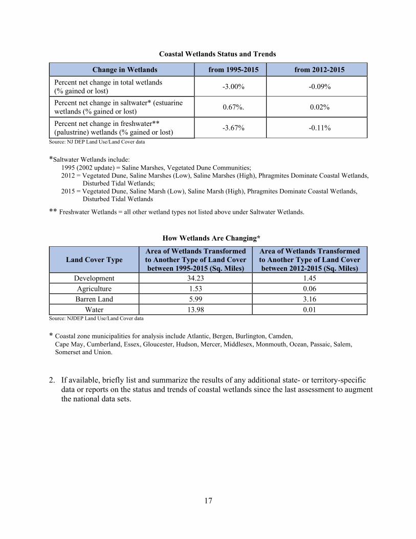
Coastal Wetlands Status and Trends
Change in Wetlands from 1995-2015 from 2012-2015
Percent net change in total wetlands (% gained or lost) -3.00% -0.09%
Percent net change in saltwater* (estuarine wetlands (% gained or lost) 0.67%. 0.02%
Percent net change in freshwater** (palustrine) wetlands (% gained or lost) -3.67% -0.11%
Source: NJ DEP Land Use/Land Cover data
*Saltwater Wetlands include: 1995 (2002 update) = Saline Marshes, Vegetated Dune Communities; 2012 = Vegetated Dune, Saline Marshes (Low), Saline Marshes (High), Phragmites Dominate Coastal Wetlands,
Disturbed Tidal Wetlands; 2015 = Vegetated Dune, Saline Marsh (Low), Saline Marsh (High), Phragmites Dominate Coastal Wetlands,
Disturbed Tidal Wetlands
** Freshwater Wetlands = all other wetland types not listed above under Saltwater Wetlands.
How Wetlands Are Changing*
Land Cover Type Area of Wetlands Transformed to Another Type of Land Cover between 1995-2015 (Sq. Miles)
Area of Wetlands Transformed to Another Type of Land Cover between 2012-2015 (Sq. Miles)
Development 34.23 1.45 Agriculture 1.53 0.06 Barren Land 5.99 3.16
Water 13.98 0.01 Source: NJDEP Land Use/Land Cover data
* Coastal zone municipalities for analysis include Atlantic, Bergen, Burlington, Camden, Cape May, Cumberland, Essex, Gloucester, Hudson, Mercer, Middlesex, Monmouth, Ocean, Passaic, Salem,
Somerset and Union. 2. If available, briefly list and summarize the results of any additional state- or territory-specific
data or reports on the status and trends of coastal wetlands since the last assessment to augment the national data sets.
18
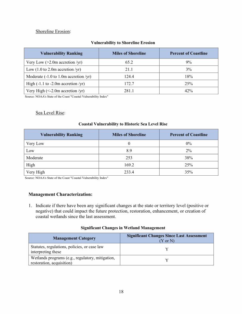
Shoreline Erosion:
Vulnerability to Shoreline Erosion
Vulnerability Ranking Miles of Shoreline Percent of Coastline
Very Low (>2.0m accretion /yr) 65.2 9% Low (1.0 to 2.0m accretion /yr) 21.1 3% Moderate (-1.0 to 1.0m accretion /yr) 124.4 18% High (-1.1 to -2.0m accretion /yr) 172.7 25% Very High (<-2.0m accretion /yr) 281.1 42%
Source: NOAA's State of the Coast "Coastal Vulnerability Index"
Sea Level Rise:
Coastal Vulnerability to Historic Sea Level Rise
Vulnerability Ranking Miles of Shoreline Percent of Coastline
Very Low 0 0% Low 8.9 2% Moderate 253 38% High 169.2 25% Very High 233.4 35%
Source: NOAA's State of the Coast "Coastal Vulnerability Index"
Management Characterization: 1. Indicate if there have been any significant changes at the state or territory level (positive or
negative) that could impact the future protection, restoration, enhancement, or creation of coastal wetlands since the last assessment.
Significant Changes in Wetland Management
Management Category Significant Changes Since Last Assessment (Y or N)
Statutes, regulations, policies, or case law interpreting these Y
Wetlands programs (e.g., regulatory, mitigation, restoration, acquisition) Y
19
2. For any management categories with significant changes, briefly provide the information below. If this information is provided under another enhancement area or section of the document, please provide a reference to the other section rather than duplicate the information:
a. Describe the significance of the changes; b. Specify if they were 309 or other CZM-driven changes; and c. Characterize the outcomes or likely future outcomes of the changes.
Statutes, regulations, policies, or case law interpreting these Amendments to Consolidate the Coastal Rules a. On July 6, 2015, the Coastal Permit Program Rules and the Coastal Zone Management
Rules were consolidated into one chapter (the CZM Rules) and amended to further encourage appropriate redevelopment of more resilient coastal communities following Superstorm Sandy. Several of these amendments impacted wetlands, including the creation of new permit-by-rule 21 for the application of pesticide in coastal wetlands to control invasive plant species in an area of 0.25 acres or less in size and new general permit 32 for the application of pesticides in coastal wetlands to control invasive plant species in an area greater than 0.25 acres in size. The management of invasive plant species in the coastal zone typically includes the application of pesticides in coastal wetlands. Invasive plants reduce the amount of biodiversity on a site, changing the habitat and reducing or eliminating the food source for native wildlife within the habitat. In addition, invasive species disrupt the existing natural communities and ecological processes by out competing the native plants within the area. Invasive plant species can also cause a reduction in revenues to natural resource-based businesses, thus creating an economic hardship, and some invasive species may be poisonous and therefore hazardous to human health. In addition, under this rulemaking, permit-by-rule 4 for the construction of nonresidential docks, piers, boat ramps, and decks located landward of the mean high water line was modified to exclude the construction of a boat ramp within wetlands. While construction of a dock, pier, or deck in accordance with the requirements applicable to those structures, including the required minimum height of the structure, will have limited impact on wetlands, the construction of a boat ramp within wetlands could result in significant impacts to or loss of wetlands. The wetland special area rule at N.J.A.C. 7:7-9.27 was amended to modify the note regarding the availability of various maps on which wetlands are identified, to modify the requirements that must be met for the use of former dredged material disposal sites where wetlands have become established, and to relocate the mitigation requirements to the new mitigation subchapter at N.J.A.C. 7:7-17, which consolidated the requirements for all mitigation required under the CZM Rules. The mitigation requirements were also updated to align with the FWPA Rules as the mitigation standards for projects involving tidal wetlands under the previous CZM Rules differed from the mitigation standards for projects involving freshwater wetlands under the FWPA Rules. These amendments also ensured the state’s tidal wetland mitigation program reflected current science.

20
b. These changes were not 309 or CZM-driven.
c. These amendments ensure additional protections for wetlands in the coastal zone and provide for mitigation practices based on the most up-to-date science.
Amendments to Coastal Wetlands Maps under the CZM Rules a. On October 17, 2016, the CZM Rules were amended to revise the boundaries reflected on
coastal wetland maps applicable to the Holgate section of Long Beach Township, Ocean County (Coastal Wetland Maps 252-2112 and 259-2112) in response to a petition for rulemaking by Kevin J. Coakley, Esq. on behalf of Mark Davies Builders & Developers LLC, David Collins and Esther Tessel Collins, Kim Lambert, and Michelle Forte. The NJDEP determined that overwash from Superstorm Sandy resulted in the loss of a portion of the property’s coastal wetlands and therefore granted the petition. In addition to analyzing the impacts of Superstorm Sandy on the property that was the subject of the rulemaking petition, the NJDEP also analyzed the impacts on adjacent properties and amended the subject maps to reflect current conditions in the area.
b. These changes were not 309 or CZM-driven.
c. Through the adopted amendments, an area of approximately 1.15 acres previously mapped as coastal wetlands on the petitioners’ property were no longer classified as coastal wetlands while an additional 1.09 acres (0.33 acres on the petitioners’ property and 0.76 acres on adjacent properties) that were not previously designated as coastal wetlands were reclassified as such, resulting in a net reduction of approximately 0.06 acres of coastal wetlands.
Amendments to the FWPA Rules a. On December 18, 2017, the FWPA Rules were amended to address implementation issues
identified since the readoption of the rules in October 2008 and to align certain procedural provisions with the CZM and FHACA Rules. In addition, the amendments included changes to certain agricultural activities that are exempt from the Freshwater Wetlands Protection Act. On January 9, 2015, the FWPA was amended by P.L. 2014, c. 89 to further exempt certain temporary farm structures from wetland permit and transition area requirements. As a result of this statutory amendment, the NJDEP added to the existing list of farming, ranching, and silviculture exemptions contained in the rules, the construction of temporary farm structures, such as hoophouses and polyhouses on farmed wetlands that were actively cultivated on or before July 1, 1988 and that have been in active agricultural use at the time that the temporary farm structures were or are to be erected. The NJDEP also added to the list of farming exemptions activities that are considered normal maintenance of cranberry bogs and blueberry fields, and activities for the renewal or rehabilitation of cranberry bogs or blueberry fields, both of which are wetland dependent crops, in order to clarify that these types of activities are part of established, ongoing cranberry and blueberry operations.

21
The rulemaking also added provisions for general permits-by-certification to the FWPA Rules and created two of these permits, general permit-by-certification 8 for construction of an addition to a lawfully existing residential dwelling and general permit-by-certification 24 for the repair or modification of a malfunctioning individual subsurface sewage disposal (septic) system. Finally, amendments to the mitigation standards were designed to clarify and/or simplify existing requirements to improve understanding of these requirements and support greater success of mitigation projects. The rulemaking also included the incorporation of the In-Lieu Fee (ILF) Program to allow those responsible for mitigation to fulfill their obligation through a monetary contribution to the ILF Program, which replaced the previous process of a monetary contribution to the Wetlands Mitigation Council.
b. These changes were not 309 or CZM-driven.
c. The amendments were designed to protect the purity and integrity of the State’s inland waterways and freshwater wetlands from random, unnecessary, or undesirable alteration or disturbance, and to provide predictability in the protection of freshwater wetland resources.
Wetlands programs (e.g., regulatory, mitigation, restoration, acquisition) Wetland and Living Shoreline Projects a. The NJDEP has undertaken the following projects for the restoration, enhancement, and/or
creation of wetlands and living shorelines: o NJDEP’s Office of Natural Resource Restoration has undertaken the removal of
landfill material to restore a tidal freshwater wetland, open waters, and upland habitat and to establish park amenities in Camden City as well as wetland restoration designs in Cape May and Salem Counties. In partnership with NJDEP’s Division of Fish and Wildlife, the office has created and restored a variety of tidal and freshwater wetland ecosystems throughout the state. The office has also funded dam removals to increase water and wetlands quality along the Raritan River, Millstone River, Paulins Kill, and Musconetcong River.
o NJDEP’s Division of Fish and Wildlife and the Division of Parks and Forestry’s Bureau of Forest Management have worked to restore Atlantic White Cedar wetlands in the Pinelands and coastal areas impacted by Superstorm Sandy.
o NJDEP’s Barnegat Bay Restoration, Enhancement and Protection Strategy (described in the Phase I Assessment for special area management plans) identifies objectives and actions aimed at restoring areas of concern (Restoration), enhancing areas wherever possible (Enhancement) and protecting healthy areas (Protection) of the Barnegat Bay and its watershed. Under this strategy, the NJDEP is currently working to finalize contracts for the following living shorelines projects in the Barnegat Bay.

22
ReClam the Bay – ReClam the Bay, part of Rutgers Cooperative Extension in partnership with the Mordecai Island Land Trust, will create a 600-foot oyster and ribbed mussel living shoreline on Mordecai Island. The USACE estimates that Mordecai Island has lost more than 35 percent of its land mass since 1920. Without efforts to stabilize the island's western shore, it will ultimately disappear along with the nursery habitat it provides for numerous fish and colonial water bird species.
Crabbe Point Pier Shoreline Stabilization - South Toms River Borough has worked closely with NJDEP since early 2018 to develop environmentally friendly solutions to restore and protect a severely eroded public shoreline area adjacent to the Crabbe Point pier. This project will support the final design and construction of a 130-foot living shoreline to stabilize, restore, and provide resiliency to this public area.
Forked River Beach, Lacey Township Living Shoreline and Oyster Reef to Improve Water Quality – This project area experiences increased turbidity due to accelerated shoreline erosion (over 108 feet due to inland progression). The American Littoral Society is partnering with Stockton University to design and construct approximately 2,600 linear feet of intertidal, shelled living shoreline, including 10 oyster reefs near the confluence of the Forked River and Barnegat Bay. The living shoreline will be located just offshore of the recently restored Lacey Township Forked River Bayfront Park.
Cattus Island County Park Living Shoreline - Cattus Island County Park is located along Silver Bay. The park preserves a significant portion of the total remaining natural ecosystem of the northern part of Barnegat Bay. The park is the most significant salt marsh in the Northern part of the Bay. Cattus Island has experienced significant erosion in recent years, with some areas having lost more than 300 feet. This project will focus on the northeast peninsula, Page's Point, a critical landmass that serves as a wetland buffer and upland forest breakwater that protects four surrounding neighborhoods from tidal flooding and erosion. This project with the Ocean County Planning Department will construct approximately 2,600 linear feet of living shoreline, including a breakwater and reef system. The project's primary goal is to restore and provide resiliency to public land.
Tuckerton Beach Living Shoreline Project - Tuckerton Borough has identified Lanyard Lagoon, which is public preserved land, as an area that experiences high rates of erosion. This project will complete the design and construction of approximately 12,800 square feet of living shoreline that will provide resiliency against boat and wind-driven wave action and provide public access.
b. These activities were not 309 or CZM-driven. c. These efforts will not only lead to the restoration, creation, enhancement, and/or
preservation of wetlands and living shorelines in New Jersey but, as they were voluntary

23
NJDEP-sponsored projects, they help to establish wetlands as an environmental priority for the state.
Grant Initiatives a. The NJCMP has partnered on various grants with many internal and external partners to
effectively leverage efforts to develop a network to promote, construct, and monitor ecologically based mitigation projects, build a sound database of techniques, and provide clear guidance for their use in New Jersey’s coastal zone. These initiatives include the following:
o The Reusing Dredged Material to Restore Salt Marshes and Protect Communities
grant program funded the establishment of three pilot project sites from 2014-2016 where dredged material was used to enhance stressed salt marshes on state-owned public lands in coastal areas in southern New Jersey. This grant was issued by the National Fish and Wildlife Foundation and the United States Department of the Interior. During this 309 assessment period, monitoring at these sites was extended for two years (2018 and 2019). The pilot marsh enhancement/dredged material beneficial use projects were the first of their kind in the state. The dredged material placement method and the type and thickness of the dredged material varied among the three projects. The enhanced marsh sites currently support varied levels of recovering plant and/or animal species. DSR coordinates and conducts long-term monitoring of these sites through a 2017 EPA Wetland Program Development Grant. Continued monitoring is necessary to evaluate the marsh enhancement/dredged material placement techniques and to track the post-placement marsh recovery process. Monitoring is also conducted at nearby marsh control areas for comparison to the marsh enhancement areas and followed a “Before, After, Control, Impact” approach. The monitoring captures metrics for plant communities, benthic infauna, sediment characteristics, habitat changes, elevation, hydroperiod, and sediment accretion/subsidence. The overall goal of the monitoring is to assess the long-term benefits and effects of using dredged material for marsh enhancement purposes. The main goal of the grant extension project was to refine the New Jersey Wetland Program Plan to improve implementation and decision-making on future salt marsh restoration/enhancement projects in New Jersey. The project will also examine monitoring data, processes, and marsh restoration projects, including those monitored through this grant, to improve state-level decision-making and to develop the framework for a decision tool for appropriate actions for marsh restoration. This information will inform salt marsh enhancement practitioners in the region and support the creation of a science-based decision-making process for marsh restoration and enhancement projects in New Jersey.
o In 2019, the NJCMP received USEPA Wetland Program development funding to develop a Coastal Ecological Restoration and Adaptation Plan (CERAP) to identify

24
priority areas for ecological restoration projects in the coastal zone. The CERAP will identify those areas that are most appropriate for future restoration, enhancement, or preservation projects that will produce the largest net carbon sequestration, ecosystem health, and community resilience value. The plan will also identify areas to target for preservation to allow for migration of coastal marshes over time. The final plan will capture many of the advancements in methods and best practices the NJDEP has advanced towards the overall wetlands program plan, including monitoring, assessment, and integration of ecological restoration projects into local resilience planning. In addition, the grant helps to fund the work of the New Jersey Tidal Wetlands Monitoring Network (described below). Funding from this grant will be used by the DSR to investigate the current trends of tidal wetlands statewide by analyzing this shared monitoring data. The trend information and monitoring data will inform the ecological restoration and adaptation plan by assisting in the identification of priority areas most appropriate for future restoration, enhancement, or preservation projects. Data will be presented in an interactive online map that is available to the public. Funding will also be used to fill gaps in the monitoring network in the Raritan and Great Egg Harbor-Tuckahoe Rivers.
b. These grant initiatives were 309-driven as the 2016-2020 Section 309 wetlands strategy
included supporting expanded and effective use of ecologically based mitigation strategies.
c. These efforts will improve the NJCMP’s knowledge and understanding of appropriate locations and methods for constructing and monitoring ecologically based mitigation and restoration projects, enabling future decisions with respect to wetlands by the state, local governments, and non-government organizations and individuals to be based on sound, local science and data.
Monitoring Projects
a. The NJCMP is participating in the following efforts for monitoring tidal wetland conditions:
o The New Jersey Tidal Wetland Monitoring Network was formed in 2018. Chaired by
the DSR, the network is composed of more than fifteen entities that collect long-term monitoring of tidal wetlands in New Jersey, the network will focus on improving the resilience of coastal communities and ecosystems by identifying current conditions and trends in tidal wetlands in New Jersey to help prioritize restoration efforts and inform management decisions.
o ONLM is conducting assessments of the condition of freshwater and tidal wetlands statewide with the support of the Water Resources Management program. The programs are utilizing wetland assessment tools developed for the 2011 National Aquatic Resource Survey (NARS) and 2016 National Wetland Condition Assessments (NWCA) that employ the USEPA’s three-tiered, multi-scale approach (landscape remote sensing, rapid field, and intensive field assessment) in conjunction with an Ecological Integrity Assessment Protocol developed by NatureServe and the ONLM Natural Heritage Program. In 2021, DSR and ONLM scientists plan to

25
participate in the NWCA for freshwater and tidal wetlands and to provide support to the USEPA during their assessment of five additional reference condition salt marsh sites in New Jersey. Data from the NWCA surveys have been used to evaluate ecoregional and watershed data on coastal wetlands and to examine the use of diatoms as indicators of condition.
o The Mid-Atlantic Coastal Wetlands Assessment (MACWA) Program, part of the
EPA Mid-Atlantic Wetlands Monitoring Workgroup (MAWWG), was first implemented in New Jersey in 2010 and represents a partnership between two national estuary programs, federal and state agencies, and academic institutions. The MACWA program is the first wetland program to study tidal wetland health in the region and has been collecting data in a multi-tiered regional approach that has science-based and tested protocols associated with each tier. While the regional approach allows for local application and the ability to investigate and compare local wetland conditions, the tiered MACWA design provides rigorous and comparable data across the Mid-Atlantic region with monitoring and research studies. The four tiers include:
• Tier 1: Landscape census surveys of the extent and condition of tidal wetlands.
• Tier 2: On the ground random sampling across the study region(s) to assess condition and ensure validity of Tier 1 studies. This tier includes Rapid Assessment and MidTRAM methods and Ecological Integrity Assessment (EIA).
• Tier 3: Research. Intensive quantitative studies to examine the relationships among condition, function, and stressor impacts in order to provide baseline and reference monitoring data and to resolve unanswered questions.
• Tier 4: Intensive monitoring of the condition and function at fixed stations to study changes over time achieved through Site Specific Intensive Monitoring (SSIM). New Jersey has 10 MACWA Site Specific Intensive Monitoring stations.
The NJDEP’s goal in prioritizing the MACWA Program is to have a consistent and comprehensive monitoring approach, including core metrics for coastal wetlands, that will inform restoration and resilient and sustainable conservation and management practices.
b. These grant initiatives were 309-driven as the 2016-2020 Section 309 wetlands strategy
included supporting expanded and effective use of ecologically based mitigation strategies through monitoring and assessment of the efficacy of those strategies. Also, CZM funds have been used to maintain and advance MACWA.
26
c. These efforts will improve the NJCMP’s knowledge and understanding of the current state of New Jersey’s tidal wetlands as well as appropriate methods for monitoring conditions in these wetlands, which will inform future policy and project decisions.
The Regional Greenhouse Gas Initiative
a. On January 29, 2018, Governor Phil Murphy signed Executive Order No. 7 directing the NJDEP and the Board of Public Utilities (BPU) to take all necessary regulatory and administrative measures to ensure New Jersey’s timely return to full participation in the Regional Greenhouse Gas Initiative (RGGI), which is the first mandatory market-based program in the nation to reduce greenhouse gas emissions. RGGI is a cooperative effort among the states of Connecticut, Delaware, Maine, Maryland, Massachusetts, New Hampshire, New Jersey, New York, Rhode Island, and Vermont to cap and reduce carbon dioxide emissions from the power sector. RGGI is composed of individual CO2 Budget Trading Programs in each participating state. Through independent regulations, based on the RGGI Model Rule, each state's CO2 Budget Trading Program limits emissions of CO2 from electric power plants, issues CO2 allowances, and establishes participation in regional CO2 allowance auctions. After working with the other RGGI states to determine how best to re-engage in the RGGI program, the NJDEP adopted two rules on June 17, 2019. The CO2 Budget Trading Program rule proposal established New Jersey’s portion of the overarching RGGI program, including the regional cap and applicability requirements for regulated entities. It also incorporated the Global Warming Solutions Fund, established by N.J.S.A. 26:2C50, which is credited with monies received as a result of the carbon dioxide allowance auctions. The Global Warming Solutions Fund Act rule established a framework, including the guidelines and the priority ranking system, that the NJDEP, the Economic Development Authority, and the BPU will use to select eligible programs and projects to receive RGGI auction proceeds. As per this rule, 10 percent of the Global Warming Solutions Fund shall be allocated to the NJDEP to enhance the stewardship and restoration of the State’s forests and tidal marshes.
b. This change was not 309 or CZM-driven.
c. This program provides necessary funding to assist the NJCMP with the restoration and protection of coastal wetlands, which among their other ecological benefits, provide important opportunities to sequester or reduce greenhouse gases.
Enhancement Area Prioritization: 1. What level of priority is the enhancement area for the coastal management program?
High __X__ Medium ______ Low ______
27
2. Briefly explain the reason for this level of priority. Include input from stakeholder engagement, including the types of stakeholders engaged.
According to the NJCMP’s survey (described in further detail in the Summary of Stakeholder and Public Comment section of this document), 78.9 percent of respondents have been involved with wetlands projects over the past five years, including restoration of coastal wetlands, shoreline protection, and living shorelines. The surveyed stakeholders identified wetlands as one of their top priority enhancement areas. Stakeholders also expressed significant interest in wetlands at the 309 stakeholder session held at Monmouth University on January 15, 2020. The names and types of participating stakeholders can be found in Appendix A of this document. Furthermore, as summarized above, New Jersey is at risk of losing its coastal wetlands. The vulnerability index indicates that 42 percent of the New Jersey coastline is highly vulnerable to shoreline erosion while 98 percent is moderately to highly vulnerable to sea level rise. Coastal storms and hazards continue to have a severe impact on New Jersey’s tidal wetlands, negatively impacting habitat for aquatic flora and fauna and reducing community resiliency. As a result of these concerns, supported by the stakeholders’ responses, the NJCMP is rating wetlands as a high priority enhancement area.
28
Coastal Hazards
Section 309 Enhancement Objective: Prevent or significantly reduce threats to life and property by eliminating development and redevelopment in high-hazard areas, managing development in other hazard areas, and anticipating and managing the effects of potential sea level rise and Great Lakes level change. §309(a)(2)
Note: For purposes of the Hazards Assessment, coastal hazards include the following traditional hazards and those identified in the CZMA: flooding; coastal storms (including associated storm surge); geological hazards (e.g., tsunamis, earthquakes); shoreline erosion (including bluff and dune erosion); sea level rise; Great Lake level change; land subsidence; and saltwater intrusion.
PHASE I (HIGH-LEVEL) ASSESSMENT: (Must be completed by all states.) Purpose: To quickly determine whether the enhancement area is a high-priority enhancement objective for the CMP that warrants a more in-depth assessment. The more in-depth assessments of Phase II will help the CMP understand key problems and opportunities that exist for program enhancement and determine the effectiveness of existing management efforts to address those problems. Resource Characterization: 1. In the table below, indicate the general level of risk in the coastal zone for each of the coastal
hazards. The following resources may help assess the level of risk for each hazard. Your state may also have other state-specific resources and tools to consult. Additional information and links to these resources can be found in the “Resources” section at the end of the Coastal Hazards Phase I Assessment Template:
• The state’s multi-hazard mitigation plan. • Coastal County Snapshots: Flood Exposure • Coastal Flood Exposure Mapper • Sea Level Rise Viewer/Great Lakes Lake Level Change Viewer • National Climate Assessment
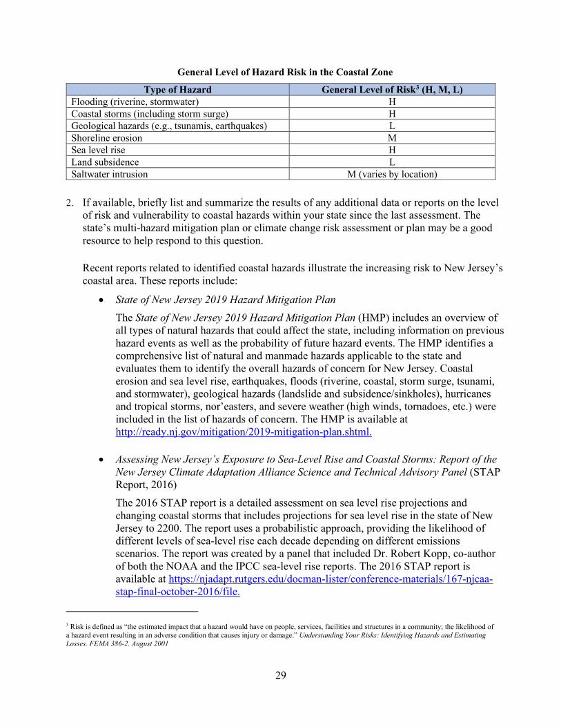
29
General Level of Hazard Risk in the Coastal Zone
Type of Hazard General Level of Risk3 (H, M, L) Flooding (riverine, stormwater) H Coastal storms (including storm surge) H Geological hazards (e.g., tsunamis, earthquakes) L Shoreline erosion M Sea level rise H Land subsidence L Saltwater intrusion M (varies by location)
2. If available, briefly list and summarize the results of any additional data or reports on the level
of risk and vulnerability to coastal hazards within your state since the last assessment. The state’s multi-hazard mitigation plan or climate change risk assessment or plan may be a good resource to help respond to this question.
Recent reports related to identified coastal hazards illustrate the increasing risk to New Jersey’s coastal area. These reports include:
• State of New Jersey 2019 Hazard Mitigation Plan The State of New Jersey 2019 Hazard Mitigation Plan (HMP) includes an overview of all types of natural hazards that could affect the state, including information on previous hazard events as well as the probability of future hazard events. The HMP identifies a comprehensive list of natural and manmade hazards applicable to the state and evaluates them to identify the overall hazards of concern for New Jersey. Coastal erosion and sea level rise, earthquakes, floods (riverine, coastal, storm surge, tsunami, and stormwater), geological hazards (landslide and subsidence/sinkholes), hurricanes and tropical storms, nor’easters, and severe weather (high winds, tornadoes, etc.) were included in the list of hazards of concern. The HMP is available at http://ready.nj.gov/mitigation/2019-mitigation-plan.shtml.
• Assessing New Jersey’s Exposure to Sea-Level Rise and Coastal Storms: Report of the New Jersey Climate Adaptation Alliance Science and Technical Advisory Panel (STAP Report, 2016) The 2016 STAP report is a detailed assessment on sea level rise projections and changing coastal storms that includes projections for sea level rise in the state of New Jersey to 2200. The report uses a probabilistic approach, providing the likelihood of different levels of sea-level rise each decade depending on different emissions scenarios. The report was created by a panel that included Dr. Robert Kopp, co-author of both the NOAA and the IPCC sea-level rise reports. The 2016 STAP report is available at https://njadapt.rutgers.edu/docman-lister/conference-materials/167-njcaa-stap-final-october-2016/file.
3 Risk is defined as “the estimated impact that a hazard would have on people, services, facilities and structures in a community; the likelihood of a hazard event resulting in an adverse condition that causes injury or damage.” Understanding Your Risks: Identifying Hazards and Estimating Losses. FEMA 386-2. August 2001
30
• New Jersey’s Rising Seas and Changing Coastal Storms: Report of the 2019 Science and Technical Advisory Panel (STAP Report, 2019) In preparation for the development of a New Jersey Coastal Resilience Plan and state guidance for the use of sea-level rise projections, the NJCMP commissioned the Rutgers Science and Technical Advisory Panel to update their 2016 report on sea-level rise. The new projections incorporate new data on ice sheet dynamics and expand consideration of tidal flooding and storm tide-related flooding. The 2019 STAP Report is currently considered the best available science for the State of New Jersey. The report is available at https://www.nj.gov/dep/climatechange/pdf/nj-rising-seas-changing-coastal-storms-stap-report.pdf.
• First Street Foundation - State by State Analysis: Property Value Loss from Sea Level
Rise The First Street Foundation report evaluated housing market impacts due to increased flooding driven by sea-level rise. Between 2005 and 2017, New Jersey experienced an estimated $4.5 billion loss in relative home value. The five cities experiencing the most significant loss include Ocean City, Beach Haven, Sea Isle City, Atlantic City, and Avalon. This report can be found at https://firststreet.org/press/property-value-loss-from-sea-level-rise-state-by-state-analysis/.
• Union of Concerned Scientists – Rising Seas, Chronic Floods, and the Implications for
US Coastal Real Estate The UCS report estimates the number of homes and commercial properties throughout the coastal United States that are at risk in the coming decades from chronic, disruptive flooding, which the report defines as flooding that occurs 26 times per year or more. The states with the greatest potential losses are Florida and New Jersey. More than 62,000 homes in New Jersey are projected to be at risk from chronic flooding. Ten New Jersey towns are projected to have at least 1,500 homes at risk by 2045. Ocean City is at the top of the list with more than 7,200 at-risk homes. For the full report, see https://www.ucsusa.org/sites/default/files/attach/2018/06/underwater-analysis-full-report.pdf.
• Rhodium Group – New Jersey’s Rising Coastal Risk
The Rhodium Group’s report seeks to quantify the impact of changes in hazards from flood and wind exposure over the past 40 years and to project how coastal risk will evolve in the years ahead as the climate changes. The primary conclusions of this report are:
o The risk from tidal flooding has more than doubled. New Jersey has seen a 110 percent increase in the number of homes at risk from frequent flooding since 1980. An additional 23,000 homes worth a combined total of $13 billion are now at risk from frequent flooding while 27,000 more buildings worth a combined total of $15 billion are now likely to flood at least once per year.
31
o Hurricane risk is expanding. Since 1980, between 62,000 and 86,000 more properties, worth over $60 billion collectively, are now located in areas with a 1-in-30 chance of hurricane flooding.
o New Jersey’s risk is projected to grow. By 2050, an additional 33,000 to 58,000 buildings in the state are expected to experience frequent flooding. The average annual hurricane flood and wind damage costs will likely increase by $1.3 to $3.1 billion.
The full report is available at https://rhg.com/research/new-jersey-flooding-hurricanes-costs-climatechange/.
Management Characterization: 1. In the tables below, indicate if the approach is employed by the state or territory and if
significant state- or territory-level changes (positive or negative) have occurred that could impact the CMP’s ability to prevent or significantly reduce coastal hazards risk since the last assessment.
Significant Changes in Hazards Statutes, Regulations, Policies, or Case Law
Topic Addressed
Employed by State or
Territory (Y or N)
CMP Provides Assistance to Locals that
Employ (Y or N)
Significant Changes Since
Last Assessment (Y or N)
Elimination of development/redevelopment in high-hazard areas4 Y N Y
Management of development/redevelopment in other hazard areas Y N Y
Climate change impacts, including sea level rise or Great Lakes level change Y N Y
Significant Changes in Hazards Planning Programs or Initiatives
Topic Addressed
Employed by State or
Territory (Y or N)
CMP Provides Assistance to Locals that
Employ (Y or N)
Significant Changes Since
Last Assessment (Y or N)
Hazard mitigation Y Y Y Climate change impacts, including sea level rise or Great Lakes level change Y Y Y
4 Use state’s definition of high-hazard areas.

32
Significant Changes in Hazards Mapping or Modeling Programs or Initiatives
Topic Addressed
Employed by State or
Territory (Y or N)
CMP Provides Assistance to Locals that
Employ (Y or N)
Significant Changes Since
Last Assessment (Y or N)
Sea level rise or Great Lakes level change Y Y Y Other hazards Y Y Y
2. Briefly state how “high-hazard areas” are defined in your coastal zone.
At N.J.A.C. 7:7-9.18, the CZM Rules define coastal high hazard areas as flood prone areas subject to high velocity waters as delineated on FEMA flood mapping (V zones) and areas within 25 feet of oceanfront shore protection structures that are subject to wave run-up and overtopping. V zones are areas that are potentially subject to breaking wave heights three feet or more above the tidal stillwater elevation during a 100-year flood, which is a flood that statistically has a one percent chance of being equaled or exceeded in any given year. “FEMA flood mapping” refers to information published or publicly released by FEMA regarding the frequency, location, and/or extent of flooding in a community, such as flood elevations (including FEMA’s 100-year flood elevation), flood profiles, flow rates, and floodway limits. For the purposes of the CZM Rules, such information shall include only that information adopted as part of the most recent effective FEMA Flood Insurance Study, dated on or after January 31, 1980, or any more recent advisory or proposed (preliminary) flood mapping if the more recent advisory or proposed (preliminary) mapping results in higher flood elevations, wider floodway limits, and greater flow rates than depicted in the most recent effective FEMA Flood Insurance Study or indicates a change from an A zone to a V zone or a coastal A zone. Coastal high hazard areas are considered a special area under the CZM Rules as they are considered sufficiently hazardous to merit focused attention and special management rules. The coastal high hazard area extends from offshore to the inland limit of a primary frontal dune along an open coast and any other area subject to high velocity wave action from storms or seismic sources. The inland limit of the V zone is defined as the V zone boundary line as designated on FEMA flood mapping or the inland limit of the primary frontal dune, whichever is most landward.
3. For any management categories with significant changes, briefly provide the information below. If this information is provided under another enhancement area or section of the document, please provide a reference to the other section rather than duplicate the information:
a. Describe the significance of the changes; b. Specify if they were 309 or other CZM-driven changes; and c. Characterize the outcomes or likely future outcomes of the changes.

33
Hazards statutes, regulations, policies, or case law
Regulatory Amendments to the CZM Rules a. On January 16, 2018, the Department adopted amendments to the CZM Rules to facilitate
consistency with the Flood Hazard Area Control Act (FHACA) Rules at N.J.A.C. 7:13, the Uniform Construction Code (UCC) at N.J.A.C. 5:23, and federal flood reduction requirements at 44 CFR Part 60. These amendments were designed to promote wise use of the coast and protect coastal residents and their property from harm while acknowledging the development history of certain areas in the state. Development in V zones (as defined above) is particularly vulnerable to damage from flooding and waves during coastal storms. Therefore, V zones require stringent building standards to protect the public from the impacts of storms and flooding. For this reason, the Federal Emergency Management Agency (FEMA) and the New Jersey Department of Community Affairs (NJDCA) adopted additional standards for buildings located in these areas to ensure that such buildings are suitably resistant to displacement, buoyancy, and structural damage during flood events. The NJDEP’s FHACA Rules have been amended for consistency with FEMA standards and the UCC requirements and incorporate lowest floor elevation requirements designed to protect public health and safety. In developing the regulatory amendments to the CZM Rules necessary for consistency with these standards, NJDEP staff met with representatives from FEMA and NJDCA. The amendments included changing the definition of coastal high hazard areas to replace the term “FIRM” with “FEMA flood mapping” and allowing the use of advisory or preliminary FEMA maps to be considered when determining which activities are appropriate on a given site. The Department has determined that the detailed analysis conducted by FEMA in developing the preliminary or advisory maps makes these maps the best available flood data. The amendments also addressed the acceptability of residential, commercial, and water dependent development as well as amusements within coastal high hazard areas. Under the amended rule, residential and commercial development is prohibited in coastal high hazard areas with limited exceptions. Residential development landward of the mean high water line in coastal high hazard areas is conditionally acceptable where the development is a single-family home or duplex in-fill development or a residential development located either in Atlantic City or in special urban areas within the Hudson River Waterfront area, provided the development complies with the UCC and the federal flood reduction standards at 44 CFR 60. In addition, the amendments allow for the construction of hotel and commercial development in coastal high hazard areas in Atlantic City or in special urban areas within the Hudson River Waterfront area where the development complies with the specific special area rule for the location of the development and the development complies with the federal flood reduction standards (44 CFR 60) and the UCC.
34
Finally, the amendments allow for water dependent development and amusements in coastal high hazard areas, provided the development complies with the UCC and the federal flood reduction standards.
b. These changes were not 309 or CZM-driven.
c. These amendments promote wise use of the coast and protect coastal residents and their property from harm. The changes to the definition of coastal high hazard area use the best available flood data to determine which activities are appropriate on a given site. Residential development (other than limited infill development) and commercial development in coastal high hazard areas are limited to the Hudson River Waterfront area and Atlantic City, allowing reasonable development in areas that are already densely developed while protecting people and property from the negative impacts of flooding and coastal storms by requiring compliance with the federal flood reduction standards and the UCC. The rules also allow reasonable hotel and commercial development essential to the tourism economy in key areas of the state but protect people and property from flooding and coastal storms through compliance with the UCC and federal standards. The prohibition of all other residential and commercial development in coastal high hazard areas will reduce potential risk in the state. Allowing water-dependent development, such as marinas, and amusements provides an alternative to appropriately utilize coastal areas without posing a significant risk to communities. When constructed in accordance with the federal flood reduction standards and the UCC, these developments do not pose a significant risk to communities during storms and flood events and are preferable to permanent residences in order to reduce the number of people in harm’s way. Amusements are also an essential component to the state’s coastal tourism economy.
Executive Order No. 89 a. Signed by Governor Phil Murphy on October 29, 2019, Executive Order No. 89 responds
to the increasing threats of climate change in New Jersey. The order established a Chief Resilience Officer (CRO) and a Climate and Flood Resilience Program within NJDEP as well as the Interagency Council on Climate Resilience for New Jersey. The order charges the CRO and the council with the development of a statewide Climate Change and Resilience Strategy and a Coastal Resilience Plan. In addition, the State Planning Commission is tasked with incorporating climate change considerations as a mandatory requirement for plan endorsement of local development and redevelopment plans. Finally, the order tasks NJDEP’s Climate and Flood Resilience program with the development of a scientific report on climate change. The report will be based on existing data and the best available science regarding the current and anticipated environmental effects of climate change in New Jersey, including but not limited to increased temperatures, sea level rise, increased frequency or severity of rainfall, storms and
35
flooding, increased forest fires, and increased frequency and severity of droughts, as anticipated by scientists through at least 2050. This scientific report must be delivered to the governor within 180 days of the EO and must then be updated at least every two years to reflect the latest available climate change science. The EO is available at https://nj.gov/infobank/eo/056murphy/pdf/EO-89.pdf.
b. Although not directly 309-driven, the EO was recommended by the NJCMP.
c. This executive order provides the mechanisms needed for state agencies to begin collaborating effectively to address climate change. The CRO and the council will facilitate that collaboration. The Climate Change and Resilience Strategy and the Coastal Resilience Plan will guide future state actions to address the threats of climate change and will include sections on actions the state should take, methodologies for decision-making and collaboration with municipalities, and recommendations for financing strategies. The Climate and Flood Resilience Program’s scientific report on climate change will leverage existing studies to inform decision-makers at all levels with respect to how environmental resources may be affected by future climate conditions and associated hazards and will also link the existing scientific research with anecdotal understanding to highlight research gaps where additional studies are warranted.
Executive Order No. 100/Administrative Order 2020-01 a. Signed by Governor Phil Murphy on January 27, 2020, Executive Order No. 100 directs
NJDEP to “integrate climate change considerations, such as sea-level rise, into its regulatory and permitting programs, including but not limited to, land use permitting, water supply, stormwater and wastewater permitting and planning” and also directs NJDEP Commissioner Catherine McCabe to issue an administrative order identifying the “DEP regulations that the Department plans to update in order to integrate climate change considerations” into its programs. In response to Executive Order No. 100, Commissioner McCabe immediately issued Administrative Order 2020-01. The AO directs the Department to propose and adopt regulations within two years for Protecting Against Climate Threats (PACT), incorporating climate change considerations into the CZM Rules, FWPA Rules, FHACA Rules, and Stormwater Management Rules. It also directs sea-level rise guidance to be issued to assist NJDEP programs determine the most appropriate projections applicable. For more information on NJ PACT, see https://www.nj.gov/dep/njpact/. The EO is available at https://nj.gov/infobank/eo/056murphy/pdf/EO-100.pdf. For the AO, visit https://www.nj.gov/dep/njpact/docs/dep-ao-2020-01.pdf.
b. These changes were not 309 or CZM-driven.

36
c. The executive order and administrative order provide the directive and timeline for significant updates to the regulations and guidance of the NJCMP that will ultimately make New Jersey’s coastal zone more resilient to climate change and coastal hazards.
Hazards Planning Programs or Initiatives
Sustainable and Resilient Coastal Communities (S&RCC) a. The objectives of the S&RCC project were to identify municipal actions in response to
coastal hazards for the protection of New Jersey’s coastal resources while meeting the needs of the community and to inform the CZM Rules for development in conjunction with New Jersey’s Coastal Area Facility Review Act (CAFRA).
b. This project was 309-driven.
c. The final report included recommendations for planning actions as well as considerations for changes to the CZM Rules. The final report is available at https://www.njfuture.org/wp-content/uploads/2017/12/New-Jersey-Future-Resilient-Coastal-Communities-Project-Report-2017.pdf.
New Jersey Foster Regional Adaptation through Municipal Economic Scenarios (NJ FRAMES) a. The NJ FRAMES project is a regional and collaborative effort in coastal Monmouth
County that seeks to understand and begin to address our future flood vulnerability. The result will be a long-term Regional Resilience and Adaptation Action Plan that will identify ways communities can reduce risks and impacts. The project is based on the framework laid out in NOAA’s report What Will Adaptation Cost: An Economic Framework for Coastal Community Infrastructure and is piloting the use of total-water-levels and a comprehensive regional planning effort consistent with, although not funded by, the 2016-2020 309 strategy for coastal hazards. NJ FRAMES is scheduled to be completed by March 2020.
b. This change was driven by an award the NJCMP received through NOAA’s Regional Coastal Resilience grant program.
c. The project’s final product will be a plan for the region to implement resilience actions. However, there is no associated funding for implementation.
Resilient NJ a. Resilient NJ is a regional resilience planning grant program funded by the United States
Department of Housing and Urban Development (HUD) through the National Disaster Resilience Competition. Four multi-municipal regions in the state have been selected to participate in the program. Each region includes at least one community-based organization as part of the group in order to help ensure representation of socially vulnerable populations in the planning process. Each region will be partnered by a consultant team to facilitate a
37
regional planning process, which will include a review of existing plans, visioning, risk assessment, the development of at least three scenarios, the selection and refinement of a preferred scenario, and the development of a final Resilience and Adaptation Action Plan for the region. Funds are also available to implement additional planning actions identified as part of the planning process. In addition, the Resilient NJ program is providing grants to three non-government organizations in order to provide resources and support for the planning processes. Enterprise Community Partners will be providing guidance and support for the engagement of socially vulnerable populations in the program. Stevens University will be updating the Living Shorelines Guidelines for NJ with a new focus on developing living shorelines in urban areas. Finally, a team from Rutgers and South Dakota State Universities will be researching best practices for environmental management of acquisition properties. The program is largely based on the NJ FRAMES template and continues the implementation of a comprehensive planning effort that is consistent with, although not funded by, the 2016-2020 309 coastal hazards strategy. NJ FRAMES is scheduled to be completed by May 2022.
b. While the grants and contracts are funded by the HUD award, NJCMP staff administer the program, which was built on and is consistent with the Section 309 coastal hazards strategy for the 2016-2020 assessment cycle and the NJ FRAMES project funded by the Regional Coastal Resilience grant program.
c. The Resilient NJ program will provide the four participating regions with a plan to implement resiliency actions as well as funding for implementation of some recommendations.
Coastal Resilience Plan (CRP)
a. The CRP will identify state-level policies, regulations, resource allocations, and funding in the coastal zone. Pursuant to Executive Order No. 89, the CRP will make recommendations for the long-term resilience and adaptation of the coastal zone. The CRP will include a vulnerability assessment, description of recent and planned investments, recommendations for decision-making methodologies, recommendations for further actions to assist coastal communities plan for, mitigate, and adapt to coastal hazards, and financing strategies to fund such measures.
b. This change was CZM-driven. The NJCMP recommended development of the CRP and will fund and develop the plan.
c. The recommendations identified in the CRP will guide future actions of the NJCMP, NJDEP, and other state agencies to ensure New Jersey’s coastal zone is more resilient to coastal hazards.
A Seat at the Table – Project of Special Merit
a. In 2018, the NJCMP was awarded a NOAA Project of Special Merit Award for “A Seat at the Table: Integrating the Needs and Challenges of Underrepresented and Socially
38
Vulnerable Populations into Coastal Hazards Planning in New Jersey.” Socially vulnerable populations have distinct needs within resilience planning, and strong efforts are needed to properly engage them in the planning process. This research grant, conducted by Rutgers University and the Jacques Cousteau National Estuarine Research Reserve in partnership with the NJCMP, will develop guidance, training, tools, and policy recommendations for how to improve coastal resilience planning processes to meet the needs of socially vulnerable populations. As part of this grant, data on socially vulnerable populations has been collected and is available through the NJFloodMapper tool at https://www.njfloodmapper.org/. Training modules will include sections on whole community planning, using data to identify socially vulnerable population, and methods for engagement. The project is scheduled to be completed by March 2020.
b. This change was 309-driven. The grant is specifically tied to the Section 309 coastal hazards strategy from the 2016-2020 assessment cycle.
c. Planning for socially vulnerable populations, which has been thoroughly integrated into the protocol for the Resilient NJ program and made a focus area in the Coastal Resilience Plan, will be integral to all NJCMP resilience planning efforts in the coming years. The NJCMP will look for opportunities to present the training developed through this project to resilience professionals, municipal leaders, and other groups that are involved in resilience planning efforts.
Risk Management Communications Initiative – Project of Special Merit a. In 2019, the NJCMP was awarded a NOAA Project of Special Merit Award for “Risk
Communication: A Campaign for Coastal New Jersey.” This project includes the development and implementation of a risk communications campaign to involve and inform the public about the impacts of coastal hazards and the actions the public can take to reduce risk. The goal of this campaign is to reduce the threats to life and property by increasing public awareness of the impacts of coastal hazards and recommending actions to reduce risk, which will be accomplished through effective communication using innovative approaches and outreach methods and materials that are tailored to the needs of local communities and local decision-makers. The project is scheduled to be completed by March 2021.
b. This change was 309-driven. The grant is specifically tied to the Section 309 coastal hazards strategy from the 2016-2020 assessment cycle.
c. This grant project will engage New Jersey stakeholders in a conversation about the risks associated with coastal hazards and will seek to influence the public’s awareness and perception of these risks. A targeted public survey will be conducted to gather baseline information on risk perception. Communications materials and a social media strategy will be developed to disseminate information to the public in a user-friendly manner. A NOAA Risk Communication Training will be offered to local decisions-makers and community organizations to provide participants with the skills necessary to better communicate about
39
risk with their constituents. A community-based art grant program will be developed and implemented to provide artists specializing in environmental topics with funding to create art installations that communicate the risks of coastal hazards. The art grant program will culminate in a community event throughout New Jersey’s coastal zone. Finally, a webinar will be provided to disseminate lessons learned from the campaign through a peer-to-peer learning opportunity. All of the project’s deliverables will be used to enhance NJCMP programs and policies and will be posted on the NJCMP’s website for public use.
NOAA Coastal Fellow Research a. As part of the state’s efforts to engage New Jersey’s most vulnerable citizens and integrate
their needs into decision-making, the NJCMP was matched with a NOAA coastal fellow to complete a project entitled “Equitable Community Resilience: Metrics and Methods for Coastal Hazards Planning.” This project will develop a framework for equitable community resilience planning that includes recommendations for inclusive engagement processes and adaptation actions and outcomes that holistically address the underlying causes of social vulnerability. This project also aims to develop evaluation materials that can be used in coordination with the planning framework to help assess equitable planning processes both during and after process implementation. The main objectives of this project are to advance the equitable engagement of traditionally underrepresented populations in New Jersey’s resilience planning efforts and to better align resilience planning actions with equitable outcomes for these populations. The project is scheduled to be completed by August 2021.
b. This project is CZM-driven.
c. A literature review, a preliminary framework for an equitable process, and an outline for evaluation materials have been drafted and sent to advisors around the nation who have experience in equity planning and environmental justice. Following their review, the materials will be updated and presented to New Jersey stakeholders in the planning, community development, and environmental justice fields. Feedback will guide the development of final products, after which the fellow will identify opportunities within New Jersey resilience planning initiatives to disseminate the findings of the research along with recommendations for the future of climate resilience planning in New Jersey.
Blue Acres Buyout Program
a. The Blue Acres Program, first established in 1995, purchases land located in floodways. Eligible properties are those that have been storm damaged, those that are prone to incurring storm damage, and those that may buffer or protect other lands from such damage. Under the Blue Acres Program, structures are demolished, and the properties are converted to public open space that provides natural protections for communities against future severe weather events. Since 2015, the Blue Acres Program has made offers in 18 municipalities, and 1,140 properties in those 18 municipalities have been approved for buyouts with 769 homeowners

40
accepting offers. The program has closed on 711 homes, of which 669 have been demolished.
b. This program is not 309 or CZM-driven.
c. The Blue Acres Program is an important tool in New Jersey’s efforts to reduce coastal hazards. As NJDEP Commissioner Catherine McCabe stated: “The high interest in the Blue Acres program drives home the importance of efforts the state is taking to make New Jersey more resilient to flooding and extreme weather events associated with climate change.” The program is also integral to establishing state-owned public access locations along the waterfront.
Hazards Mapping or Modeling Programs or Initiatives
Resilient NJ - Watershed-level Flood Modeling
a. As part of the Resilient NJ program, the NJCMP is developing a watershed-based model to project flooding from a combined coastal and precipitation event.
b. While the grant is funded by the HUD award, NJCMP staff administer the program, which is consistent with a data gap identified in the 309 coastal hazards strategy for the 2016-2020 assessment cycle.
c. The project is intended to inform planning at a regional scale, recognizing the potential for significant precipitation as well as fluvial and coastal flooding events.
Enhancement Area Prioritization: 1. What level of priority is the enhancement area for the coastal management program?
High __X__ Medium ______ Low ______
2. Briefly explain the reason for this level of priority. Include input from stakeholder engagement, including the types of stakeholders engaged.
Governor Murphy and NJDEP Commissioner McCabe have made coastal hazards and climate resilience a high priority for the NJCMP. Multiple executive orders and an administrative order have directed the various networked offices of the NJCMP to develop strategies, plans, and regulations that address these issues, which will result in ongoing focus on coastal hazards for the foreseeable future.

41
In the NJCMP’s survey (described in further detail in the Summary of Stakeholder and Public Comment section of this document), stakeholders identified coastal hazards as their top priority enhancement area. Stakeholders also expressed significant interest in coastal hazards at the 309 stakeholder session held at Monmouth University on January 15, 2020. The names and types of participating stakeholders can be found in Appendix A of this document. In addition to stakeholder feedback, coastal hazards is a high priority enhancement area for the NJCMP due to the high projections for sea-level rise, as described earlier in this Phase I Assessment. Also, the impacts from Superstorm Sandy and other major storms continue to be felt throughout the state. Seven years after Sandy, over 700 families are still unable to return to their homes. In addition, a growing number of communities are experiencing routine flooding from high tides and precipitation due to climate change. With 239 municipalities and 53 percent of the state’s population located within New Jersey’s coastal zone, planning for coastal hazards is critical for the NJCMP. To meet the threats of climate change, sea level rise, and coastal storms, the NJCMP must continue to innovate, find additional resources, and provide guidance and support to municipalities and the public.

42
Public Access
Section 309 Enhancement Objective: Attain increased opportunities for public access, taking into account current and future public access needs, to coastal areas of recreational, historical, aesthetic, ecological, or cultural value. §309(a)(3) PHASE I (HIGH-LEVEL) ASSESSMENT: Purpose: To quickly determine whether the enhancement area is a high priority enhancement objective for the CMP that warrants a more in-depth assessment. The more in-depth assessments of Phase II will help the CMP understand key problems and opportunities that exist for program enhancement and determine the effectiveness of existing management efforts to address those problems. Resource Characterization: 1. Use the table below to provide data on public access availability within the coastal zone.
Public Access Status and Trends
Type of Access Current number5 Changes or Trends
Since Last Assessment6
Cite data source
Beach access sites
All municipal ocean and bay beaches are open to the public (beach badge required at most locations) and some privately owned beaches are open to the
public.
Atlantic Coast inventory recorded over 1,300 access ways along the
Atlantic Ocean
No change 2016-2020 309 Assessment:
Atlantic Coast Inventory 2001
Shoreline (other than beach)
access sites 1,792 miles No change
NJCMP Program Document and 2016-
2020 309 Assessment
Recreational boat (power or non-
motorized) access sites
262 boat ramps
Note: not all ramp owners choose to be listed
No change
NJ Boater’s Ramp Guide 2007 NJMSC/NJ
Sea Grant and the 2016- 2020 309 Assessment
5 Be as specific as possible. For example, if you have data on many access sites but know it is not an exhaustive list, note “more than” before the number. If information is unknown, note that and use the narrative section below to provide a brief qualitative description based on the best information available. 6 If you know specific numbers, please provide. However, if specific numbers are unknown but you know that the general trend was increasing or decreasing or relatively stable or unchanged since the last assessment, note (increased, decreased, or unchanged. If the trend is completely unknown, simply put “unkwn.”

43
Type of Access Current number Changes or Trends
Since Last Assessment
Cite data source
Number of designated scenic
vistas or overlook points Not Available Not Available Not Available
Number of fishing access
points (i.e. piers, jetties)
3,476 sites
Note: Fishing was presumed to be permitted at a site unless the
site had a “No Fishing” sign.
↑ 2,916 sites NJDEP Interactive Public Access Map (data collected September
2015-June 2017)
Coastal trails/ boardwalks
No. of Trails/ boardwalks≈33
No change
Miles of Trails/boardwalks
https://www.nps.gov/neje • Coastal Heritage Trail: 300
miles, largely highway No change
• Hudson River Waterfront Walkway: 18.5 miles
No change http://hudsonriverwaterfront.org
• Hackensack River Greenway: 3.5-mile pedestrian walkway and nature trail
No change
https://www.nynjtc.org/park/hackensack-river-greenway-through-teaneck
• Delaware River Heritage Trail: 60 miles No change https://delawareriverheritagetrail.org
• ≈29 boardwalk/promenades through beachfront municipalities: approx. 47 miles
No change
2016-2020 309 Assessment
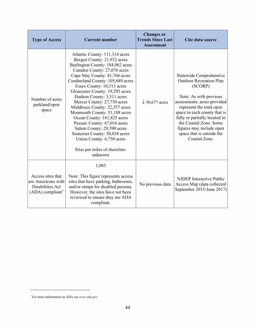
44
Type of Access Current number Changes or
Trends Since Last Assessment
Cite data source
Number of acres parkland/open
space
Atlantic County: 111,314 acres Bergen County: 21,932 acres
Burlington County: 184,962 acres Camden County: 27,076 acres
Cape May County: 81,766 acres Cumberland County: 105,689 acres
Essex County: 10,313 acres Gloucester County: 19,293 acres
Hudson County: 3,311 acres Mercer County: 27,730 acres
Middlesex County: 22,357 acres Monmouth County: 51,188 acres
Ocean County: 161,825 acres Passaic County: 67,016 acres Salem County: 29,390 acres
Somerset County: 30,038 acres Union County: 6,750 acres
Sites per miles of shoreline:
unknown
↓ 30,677 acres
Statewide Comprehensive Outdoor Recreation Plan
(SCORP)
Note: As with previous assessments, acres provided
represent the total open space in each county that is fully or partially located in
the Coastal Zone. Some figures may include open space that is outside the
Coastal Zone.
Access sites that are Americans with
Disabilities Act (ADA) compliant7
1,085
Note: This figure represents access sites that have parking, bathrooms, and/or ramps for disabled persons. However, the sites have not been reviewed to ensure they are ADA
compliant.
No previous data NJDEP Interactive Public
Access Map (data collected September 2015-June 2017)
7 For more information on ADA see www.ada.gov.

45
2. Briefly characterize the demand for coastal public access and the process for periodically assessing demand. Include a statement on the projected population increase for your coastal counties. There are several additional sources of statewide information that may help inform this response, such as the Statewide Comprehensive Outdoor Recreation Plan,8 the National Survey on Fishing, Hunting, and Wildlife Associated Recreation,9 and your state’s tourism office.
Demand for public access to New Jersey’s beaches and coastal waters is currently high and is likely to remain high since coastal waters and adjacent shorelines are a valuable but limited public resource within the state. While New Jersey is the fourth smallest state in the country, it has the highest population density with approximately 1,208 people per square mile, which is almost fourteen times the national average. Furthermore, the entirety of that population lives within 50 miles of the coastline. With such a dense population, New Jersey experiences high levels of development, which further increases the demand for public access. New Jersey’s coastal region is also a major tourist destination for two of the nation’s largest metropolitan areas, New York City and Philadelphia, as it offers a wide diversity of access to tidal waters. According to the state’s census data, the population of New Jersey’s coastal counties has increased since 2010 with a projected population growth of 2 percent between 2010 and 2020. This projection was calculated from the census data, which provided the 2010 population for each county within the coastal zone as well as estimated populations for 2018. Population data for 2019 and 2020 is not yet available. From the available data, the approximate overall percent change was calculated to be 1.6 percent between April 1, 2010 and July 1, 2018, or approximately 0.2 percent per year. Estimated percent change was also calculated for the population of each coastal county individually. See the table on the following page for detailed information. While the projected overall increase of 2 percent in New Jersey’s coastal counties over the past decade is lower than the 4.5 percent overall increase in population from 2000 to 2010, the majority of coastal counties are continuing to experience population growth, with the exceptions of Atlantic, Burlington, Camden, Cape May, Cumberland, Monmouth, and Salem counties.
8 Most states routinely develop “Statewide Comprehensive Outdoor Recreation Plans”, or SCORPs, that include an assessment of demand for public recreational opportunities. Although not focused on coastal public access, SCORPs could be useful to get some sense of public outdoor recreation preferences and demand. Download state SCORPs at www.recpro.org/scorps. 9 The National Survey on Fishing, Hunting, and Wildlife Associated Recreation produces state-specific reports on fishing, hunting, and wildlife associated recreational use for each state. While not focused on coastal areas, the reports do include information on saltwater and Great Lakes fishing, and some coastal wildlife viewing that may be informative and compares 2016 data to 2011, 2006, and 2001 information to understand how usage has changed. See www.census.gov/prod/www/fishing.html.

46
County Population in 2000
Population in 20106
% Change (2000-2010)
Estimated Population (2018)
Estimated % Change (2010-2018)
Atlantic 252,552 274,549 8.7 265,429 -3.3 Bergen 884,134 905,116 2.4 936,692 3.5
Burlington 423,394 448,731 6 445,384 -0.7 Camden 508,932 513,666 0.9 507,078 -1.3
Cape May 102,326 97,265 -4.9 92,560 -4.8 Cumberland 146,438 156,898 7.1 150,972 -3.8
Essex 793,633 783,969 -1.2 799,767 2.0 Gloucester 254,673 288,288 13.2 291,408 1.1
Hudson 608,975 634,277 4.2 676,061 6.6 Mercer 350,761 367,511 4.8 369,811 0.6
Middlesex 750,162 809,860 8 829,685 0.6 Monmouth 615,289 630,380 2.5 621,354 -1.4
Ocean 510,932 576,565 12.8 601,651 4.4 Passaic 489,049 501,616 2.6 503,310 0.3 Salem 64,285 66,083 2.8 62,607 -5.3
Somerset 297,490 323,438 8.7 331,164 2.4 Union 522,541 536,499 2.7 558,067 4.0
Avg. 4.8% Avg. 0.3% Totals 7,575,566 7,914,711 4.5% 8,043,000 1.6%
3. If available, briefly list and summarize the results of any additional data or reports on the status
or trends for coastal public access since the last assessment. Public access deed restrictions The NJDEP imposed deed restrictions for public access as a condition of 55 permits issued since 2015. These deed restrictions are requirements of the NJDEP’s regulatory process, including Waterfront Development and CAFRA permits. Municipal public access plans In 2012, the CZM Rules were amended to address when and how public access to tidal waters and their shorelines would be required. As a result of these regulatory amendments, municipalities can develop Municipal Public Access Plans (MPAPs) to address public access in their communities in a manner consistent with local planning objectives and state regulatory requirements. The MPAPs are being developed to inventory existing public access locations and facilities as well as to outline an implementation strategy that maintains existing access and allows local public access goals to be achieved. Since 2015, 61 municipalities have submitted municipal public access plans to the NJDEP. Five plans have been approved, and 39 plans are currently under active review. For the remaining 17 municipalities that submitted MPAPs, the NJDEP requested additional information but has not received a response in over a year. Moving forward, public access and the adoption of MPAPs will continue to be a priority of the NJCMP.
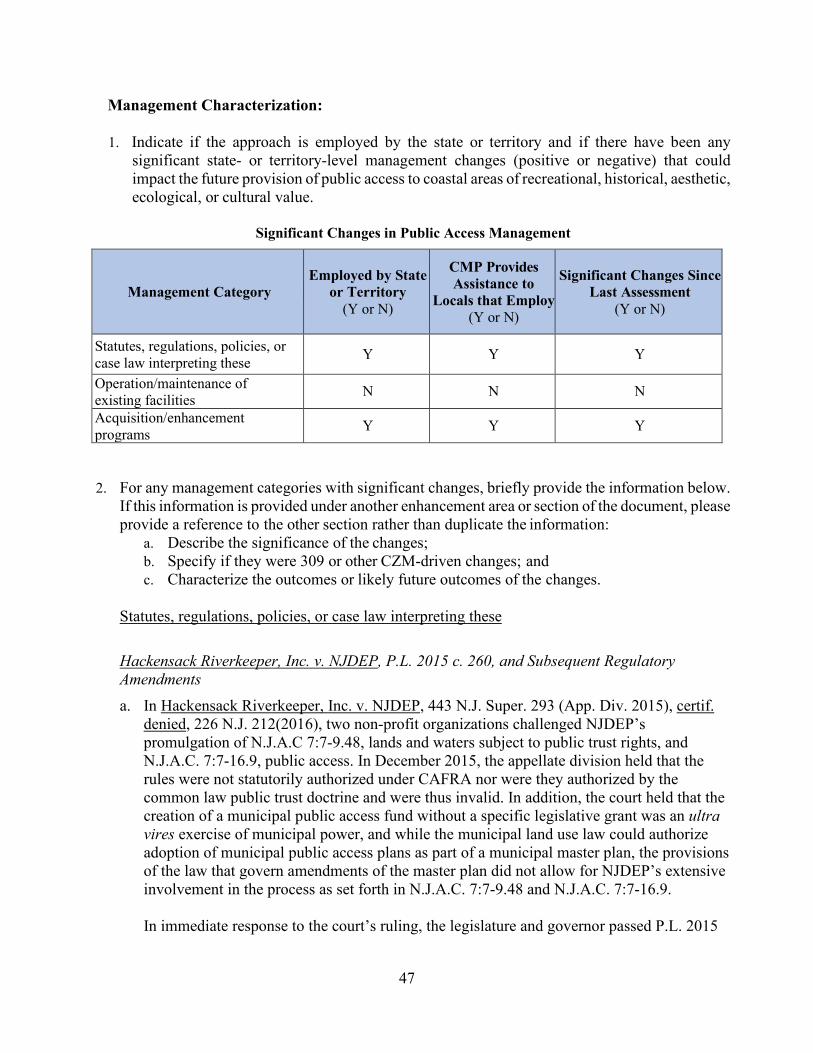
47
Management Characterization:
1. Indicate if the approach is employed by the state or territory and if there have been any significant state- or territory-level management changes (positive or negative) that could impact the future provision of public access to coastal areas of recreational, historical, aesthetic, ecological, or cultural value.
Significant Changes in Public Access Management
Management Category Employed by State
or Territory (Y or N)
CMP Provides Assistance to
Locals that Employ (Y or N)
Significant Changes Since Last Assessment
(Y or N)
Statutes, regulations, policies, or case law interpreting these Y Y Y
Operation/maintenance of existing facilities N N N
Acquisition/enhancement programs Y Y Y
2. For any management categories with significant changes, briefly provide the information below.
If this information is provided under another enhancement area or section of the document, please provide a reference to the other section rather than duplicate the information:
a. Describe the significance of the changes; b. Specify if they were 309 or other CZM-driven changes; and c. Characterize the outcomes or likely future outcomes of the changes.
Statutes, regulations, policies, or case law interpreting these
Hackensack Riverkeeper, Inc. v. NJDEP, P.L. 2015 c. 260, and Subsequent Regulatory Amendments a. In Hackensack Riverkeeper, Inc. v. NJDEP, 443 N.J. Super. 293 (App. Div. 2015), certif.
denied, 226 N.J. 212(2016), two non-profit organizations challenged NJDEP’s promulgation of N.J.A.C 7:7-9.48, lands and waters subject to public trust rights, and N.J.A.C. 7:7-16.9, public access. In December 2015, the appellate division held that the rules were not statutorily authorized under CAFRA nor were they authorized by the common law public trust doctrine and were thus invalid. In addition, the court held that the creation of a municipal public access fund without a specific legislative grant was an ultra vires exercise of municipal power, and while the municipal land use law could authorize adoption of municipal public access plans as part of a municipal master plan, the provisions of the law that govern amendments of the master plan did not allow for NJDEP’s extensive involvement in the process as set forth in N.J.A.C. 7:7-9.48 and N.J.A.C. 7:7-16.9. In immediate response to the court’s ruling, the legislature and governor passed P.L. 2015
48
c. 260 on January 19, 2016 to amend N.J.S.A. 12:5-3 (the Waterfront Development Law) and N.J.S.A. 13:19-10 (CAFRA) in order to provide the NJDEP with the necessary statutory authority to require public access to the waterfront and adjacent shorelines as a condition of an approval for waterfront development. The purpose of the legislation was to ensure the protection of the public’s right of access to tidally flowed waters and their adjacent shorelines. However, P.L. 2015 c. 260 did not grant statutory authority for a municipal public access fund or address municipal public access plans. The NJDEP subsequently adopted amendments to the CZM Rules on September 18, 2017 to repeal the fund and to ensure the standards for MPAPs were consistent with the court’s ruling.
b. These changes were not 309 or CZM-driven.
c. The legislation ensured that NJDEP has the statutory authority necessary to review and require public access as a condition of an approval for development in the coastal zone, ensuring that the public’s rights to access tidal waterways and their shores will continue to be protected. However, the court’s decision limited the Department’s authority with respect to municipal public access plans.
State v. North Beach 1003, LLC a. In State v. North Beach 1003, LLC, 451 N.J. Super. 214 (App. Div. 2017), the court
held that NJDEP has the authority under N.J.S.A. 12:3-64 and N.J.S.A. 12:6A-1 to condemn private property for perpetual easements for shore protection purposes and that the easements may include public access to, and use of, the areas covered by the easements. The court noted this was further supported by the evolution of the public trust doctrine so that public use and access is available to all on equal terms.
b. These changes were not 309 or CZM-driven. c. This ruling is expected to improve the public’s ability to access tidal waterways and
their shores. P.L. 2019 c. 81 and Regulatory Amendments a. In 2019, the legislature and governor passed P.L. 2019 c. 81, codifying the common law
public trust doctrine under which the public has inviolable rights to use the state’s tidal waters and adjacent shorelines for navigation, commerce, and recreational uses, such as bathing, swimming, and fishing. As the trustee of the public rights to tidal waterways and their shores, the state has the authority and duty under the public trust doctrine to promote and protect the public’s rights and to ensure that access to tidal waters and their adjacent shorelines is both meaningful and reasonable. This legislation confirmed that, as the state entity managing public access along the shore, the NJDEP has the authority and duty to fulfill this obligation on behalf of the state.

49
P.L. 2019 c. 81 also redefines public access to include the necessary support amenities to facilitate public access for all, such as public parking and restrooms, in addition to sufficient visual and physical access and perpendicular access from upland areas. The statute also requires the NJDEP to ensure consistency with the public trust doctrine for all issued approvals, permits, administrative orders, and consent decrees as well as any public funding issued by the department, any action taken on a project using such public funding, and any project utilizing federal funding that is regulated or reviewed by the department. Furthermore, NJDEP is required to perform a review of public access for all applications that provide for a change in the existing footprint of a structure or a change in the use of the property or that involve beach replenishment or beach and dune maintenance, including all permits-by-rule, general permits-by-certification, general permits, and individual permits issued under the CZM or FHACA Rules. Determining whether public access is appropriate and/or sufficient must be based on the scale of the changes to the footprint or use, the demand for public access in the area, and any department-approved municipal public access plan or public access element of a municipal master plan. The Office of Policy and Coastal Management is currently drafting amendments to the CZM and FHACA Rules to ensure consistency with this legislation.
b. These changes were not 309 or CZM-driven.
c. This legislation and the subsequent regulatory amendments are expected to improve the
public’s ability to access tidal waterways and their shores by impacting when and how the NJDEP reviews and requires public access. Public access requirements under the CZM Rules are currently based on the type of development being proposed. However, under P.L. 2019 c. 81, a public access review is necessary for any change in footprint or use, which is expected to broaden the scope of activities for which public access must be considered. In addition, public access reviews are now required for activities conducted under the FHACA Rules as well as for projects involving public funding or projects involving federal funding that are subject to NJDEP review.
Acquisition/enhancement programs For information on the Blue Acres Program, see the Phase I Assessment for coastal hazards.
3. Indicate if your state or territory has a publicly available public access guide. How current is the publication and how frequently it is updated?10
10 Note some states may have regional or local guides in addition to state public access guides. Unless you want to list all local guides as well, there is no need to list additional guides beyond the state access guide. However, you may choose to note that the local guides do exist and may provide additional information that expands upon the state guides.
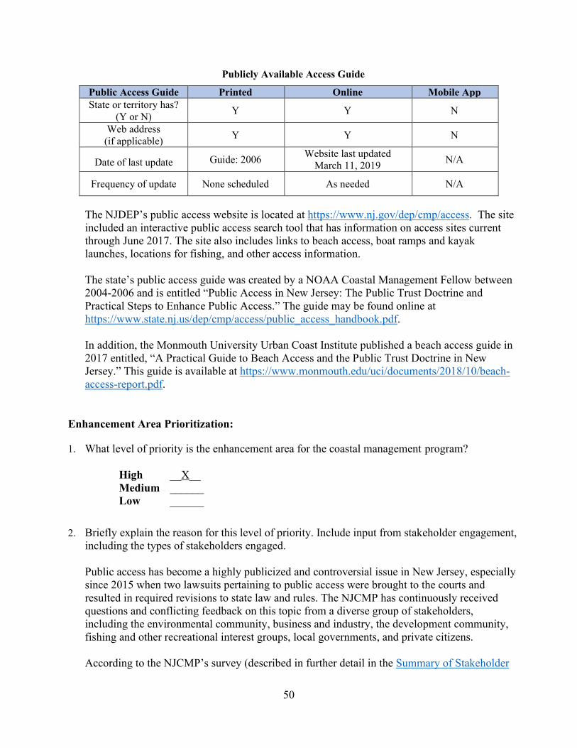
50
Publicly Available Access Guide Public Access Guide Printed Online Mobile App State or territory has?
(Y or N) Y Y N
Web address (if applicable) Y Y N
Date of last update Guide: 2006 Website last updated March 11, 2019 N/A
Frequency of update None scheduled As needed N/A
The NJDEP’s public access website is located at https://www.nj.gov/dep/cmp/access. The site included an interactive public access search tool that has information on access sites current through June 2017. The site also includes links to beach access, boat ramps and kayak launches, locations for fishing, and other access information. The state’s public access guide was created by a NOAA Coastal Management Fellow between 2004-2006 and is entitled “Public Access in New Jersey: The Public Trust Doctrine and Practical Steps to Enhance Public Access.” The guide may be found online at https://www.state.nj.us/dep/cmp/access/public_access_handbook.pdf. In addition, the Monmouth University Urban Coast Institute published a beach access guide in 2017 entitled, “A Practical Guide to Beach Access and the Public Trust Doctrine in New Jersey.” This guide is available at https://www.monmouth.edu/uci/documents/2018/10/beach-access-report.pdf.
Enhancement Area Prioritization: 1. What level of priority is the enhancement area for the coastal management program?
High __X__ Medium ______ Low ______
2. Briefly explain the reason for this level of priority. Include input from stakeholder engagement,
including the types of stakeholders engaged. Public access has become a highly publicized and controversial issue in New Jersey, especially since 2015 when two lawsuits pertaining to public access were brought to the courts and resulted in required revisions to state law and rules. The NJCMP has continuously received questions and conflicting feedback on this topic from a diverse group of stakeholders, including the environmental community, business and industry, the development community, fishing and other recreational interest groups, local governments, and private citizens. According to the NJCMP’s survey (described in further detail in the Summary of Stakeholder

51
and Public Comment section of this document), 63.2 percent of respondents have been involved with public access projects over the past five years. The surveyed stakeholders identified public access as one of their top priority enhancement areas. Stakeholders also expressed significant interest in public access at the 309 stakeholder session held at Monmouth University on January 15, 2020. The names and types of participating stakeholders can be found in Appendix A of this document. In addition, the New Jersey Legislature recently passed P.L. 2019 c. 81 (described above), which requires regulatory amendments to the public access requirements under the CZM and FHACA Rules. As part of the rulemaking process, the NJDEP has conducted vigorous stakeholder outreach, including seven stakeholder meetings to date. The feedback received during these meetings indicates the increasing significance of public access throughout the state. As a result of stakeholder interest and the recent legislation, the NJCMP is rating public access as a high priority enhancement area.

52
Marine Debris
Section 309 Enhancement Objective: Reducing marine debris entering the nation’s coastal and ocean environment by managing uses and activities that contribute to the entry of such debris. §309(a)(4) PHASE I (HIGH-LEVEL) ASSESSMENT: (Must be completed by all states and territories.) Purpose: To quickly determine whether the enhancement area is a high-priority enhancement objective for the CMP that warrants a more in-depth assessment. The more in-depth assessments of Phase II will help the CMP understand key problems and opportunities that exist for program enhancement and determine the effectiveness of existing management efforts to address those problems. Resource Characterization: 1. In the table below, characterize the existing status and trends of marine debris in the state’s
coastal zone based on the best-available data.
Existing Status and Trends of Marine Debris in Coastal Zone
2. If available, briefly list and summarize the results of any additional state- or territory-specific
data or reports on the status and trends or potential impacts from marine debris in the coastal zone since the last assessment.
11 You can select more than one, if applicable.
Source of Marine Debris Significance of
Source (H, M, L, unkwn)
Type of Impact11 (aesthetic, resource damage,
user conflicts, other)
Change Since Last Assessment (↑, ↓, -, unkwn )
Beach/shore litter H aesthetic, user conflict -
Land-based dumping L/Unknown aesthetic, resource damage, user conflict -
Storm drains and runoff M resource damage - Land-based fishing (e.g., fishing line, gear) L resource damage, user
conflict -
Ocean/Great Lakes-based fishing (e.g., derelict fishing gear)
M resource damage, user conflict ↑
Derelict vessels L aesthetic, user conflict - Vessel-based (e.g., cruise ship, cargo ship, general vessel) L user conflict -
Hurricane/Storm M resource damage ↑ Tsunami L resource damage -

53
The NJDEP and several of the NJCMP’s partner organizations hold regular marine debris cleanups along New Jersey’s coast and record the amount and/or types of debris collected. From these available records, the overall amount of marine debris available for collection appears to be decreasing. The Clean Shores Program is a free statewide service run by the NJDEP’s Division of Water Monitoring and Standards that removes floatable debris, such as wood, garbage, plastic, and recyclables, that washes onto the coast or floats in the water. From 1989 to 2018, the program has covered more miles of beach but collected fewer pounds of debris, as indicated by the graph below.
The Ocean Conservancy is a non-profit organization that works to protect the ocean and to create science-based solutions for surrounding communities and wildlife. The organization conducts international coastal cleanups each year and submits annual reports with the results. Reports dating back to 1989 are available on the Ocean Conservancy’s website at https://oceanconservancy.org/trash-free-seas/international-coastal-cleanup/annual-data-release/. The table below summarizes the results from cleanups in New Jersey over the past
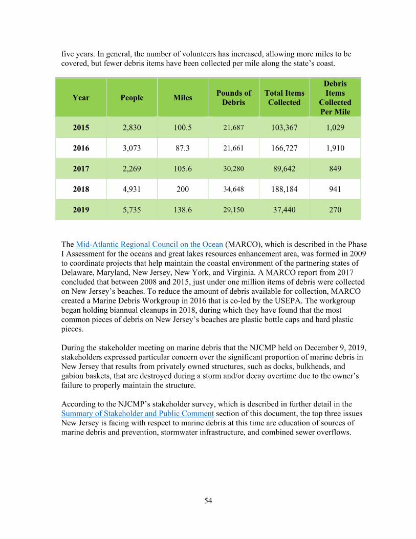
54
five years. In general, the number of volunteers has increased, allowing more miles to be covered, but fewer debris items have been collected per mile along the state’s coast.
Year People Miles Pounds of Debris
Total Items Collected
Debris Items
Collected Per Mile
2015 2,830 100.5 21,687 103,367 1,029
2016 3,073 87.3 21,661 166,727 1,910
2017 2,269 105.6 30,280 89,642 849
2018 4,931 200 34,648 188,184 941
2019 5,735 138.6 29,150 37,440 270
The Mid-Atlantic Regional Council on the Ocean (MARCO), which is described in the Phase I Assessment for the oceans and great lakes resources enhancement area, was formed in 2009 to coordinate projects that help maintain the coastal environment of the partnering states of Delaware, Maryland, New Jersey, New York, and Virginia. A MARCO report from 2017 concluded that between 2008 and 2015, just under one million items of debris were collected on New Jersey’s beaches. To reduce the amount of debris available for collection, MARCO created a Marine Debris Workgroup in 2016 that is co-led by the USEPA. The workgroup began holding biannual cleanups in 2018, during which they have found that the most common pieces of debris on New Jersey’s beaches are plastic bottle caps and hard plastic pieces. During the stakeholder meeting on marine debris that the NJCMP held on December 9, 2019, stakeholders expressed particular concern over the significant proportion of marine debris in New Jersey that results from privately owned structures, such as docks, bulkheads, and gabion baskets, that are destroyed during a storm and/or decay overtime due to the owner’s failure to properly maintain the structure. According to the NJCMP’s stakeholder survey, which is described in further detail in the Summary of Stakeholder and Public Comment section of this document, the top three issues New Jersey is facing with respect to marine debris at this time are education of sources of marine debris and prevention, stormwater infrastructure, and combined sewer overflows.

55
Management Characterization: 1. Indicate if the approach is employed by the state or territory and if there has been any
significant state- or territory-level management changes (positive or negative) for how marine debris is managed in the coastal zone.
Significant Changes in Marine Debris Management
Management Category Employed by
State or Territory (Y or N)
CMP Provides Assistance to Locals
that Employ (Y or N)
Significant Changes Since Last Assessment
(Y or N)
Marine debris statutes, regulations, policies, or case law interpreting these
Y N N
Marine debris removal programs Y N Y
2. For any management categories with significant changes, briefly provide the information below.
If this information is provided under another enhancement area or section of the document, please provide a reference to the other section rather than duplicate the information:
a. Describe the significance of the changes; b. Specify if they were 309 or other CZM-driven changes; and c. Characterize the outcomes or likely future outcomes of the changes.
Marine debris removal programs MARCO’s Joyful Send-off Campaign a. In addition to MARCO’s biannual beach cleanups, which are described above, the Marine
Debris Workgroup received a grant in 2018 for the Joyful Send-off Campaign, which is utilizing community based social marketing strategies to develop methods to reduce balloon releases throughout the partnering states. As a result of weddings, birthdays, and other celebrations commonly held along coastal beaches, balloons are a common type of marine debris, and they consist of multiple parts, such as the ribbons, attachments, and the balloon itself, that together represent a variety of hazards for marine life and the environment, such as entanglement and ingestion. The Joyful Send-off campaign will investigate the public’s understanding of the hazards associated with balloon releases and will teach and promote alternatives to balloon releases by connecting with event venues and vendors.
b. This change was not 309-driven. However, New Jersey’s participation in MARCO is funded under Section 306 of the CZMA.
c. This project aims to educate vendors and the public on the hazards associated with balloon releases and to minimize future balloon releases and their subsequent impacts on the coastal environment. The project is scheduled to be completed in July 2021.

56
Derelict Crab Pot Removal a. Many marine species can become trapped in derelict crab pots, which are often abandoned
within coastal waters. With funding from the NOAA Marine Debris Program, Stockton University and Monmouth University organized local fishermen, watermen, students, and volunteers to remove derelict pots from the coastal bays of southern New Jersey during two field seasons from December 2015 to March 2017. The derelict pots were analyzed for bycatch, growth, and whether the pot was fitted with a biodegradable panel that reduces the amount of bycatch in both active and derelict pots. All retrieved traps were disposed properly to avoid any potential future marine debris. The project goal, set by Stockton University, was to remove 1,000 derelict pots. During the first year, 395 pots were retrieved while 883 were recovered during the second year of the project for a total of 1,278 pots. The project grant has been renewed for an additional two years so that more pots can be removed, and more data can be collected to provide a better understanding of the annual accumulation of the derelict gear. The project also includes education and training for crabbers on how to prevent trap loss and how to use low-cost sonar to locate and recover lost pots during the crabbing season.
b. These changes were not 309 or CZM driven.
c. This project will reduce the amount of derelict fishing gear in New Jersey’s waterways, which will help protect marine life and the coastal environment.
Recycling Coach a. In January 2018, New Jersey launched an online platform called “Recycling Coach,” which is a
program that provides residents of different counties and municipalities with a better understanding of recycling and waste disposal practices in their local communities, such as trash and recycling pick up schedules, service cancellations, and a “What Goes Where” tool that helps residents properly separate recyclables from trash. The program now has around 685,770 users and more than four million interactions. Recycling Coach is available online on the NJDEP’s website at https://www.nj.gov/dep/dshw/rc/index.html as well as on county and municipal websites and in smart device application stores.
b. These changes were not 309 or CZM driven.
c. This project is helping educate the public to properly dispose of waste, which will help reduce marine debris.
Enhancement Area Prioritization: 1. What level of priority is the enhancement area for the coastal management program?
High ______ Medium __X__ Low ______

57
2. Briefly explain the reason for this level of priority. Include input from stakeholder engagement, including the types of stakeholders engaged.
According to the NJCMP’s survey (described in further detail in the Summary of Stakeholder and Public Comment section of this document), 66.7 percent of respondents have been involved with marine debris projects over the past five years. The surveyed stakeholders ranked marine debris as a medium to high priority enhancement area. Addressing marine debris is essential for the quality of New Jersey’s communities, waterways, and ecosystems. However, the NJCMP intends to address marine debris issues identified by both internal and external stakeholders through 306 funding and in coordination with other NJDEP programs and is therefore rating marine debris as a medium priority enhancement area.

58
Cumulative and Secondary Impacts
Section 309 Enhancement Objective: Development and adoption of procedures to assess, consider, and control cumulative and secondary impacts of coastal growth and development, including the collective effect on various individual uses or activities on coastal resources, such as coastal wetlands and fishery resources. §309(a)(5) PHASE I (HIGH-LEVEL) ASSESSMENT: (Must be completed by all states.) Purpose: To quickly determine whether the enhancement area is a high-priority enhancement objective for the CMP that warrants a more in-depth assessment. The more in-depth assessments of Phase II will help the CMP understand key problems and opportunities that exist for program enhancement and determine the effectiveness of existing management efforts to address those problems.
NOTE: The NOAA tools recommended for use do not include Mercer or Passaic Counties as “coastal.” However, both counties include municipalities with tidally flowed waters and so are considered “coastal” by the New Jersey Coastal Management Program. As such, the analysis below includes information for both.
Resource Characterization: 1. Using National Ocean Economics Program Data on population and housing,12 please indicate
the change in population and housing units in the state’s coastal counties between 2012 and 2017. You may wish to add additional trend comparisons to look at longer time horizons as well (data available back to 1970), but at a minimum, please show change over the most recent five-year period data is available (2012-2017) to approximate current assessment period.
Trends in Coastal Population and Housing Units
2012 2017 Percent Change (2012-2017)
Number of people 8,840,956 8,894,932 0.61 Number of housing
units 3,543,622 3,586,792 1.22
Source: National Ocean Economics Program Data. NJ Coastal Zone Counties in this analysis include Atlantic, Bergen, Burlington, Camden, Cape May, Cumberland, Essex, Gloucester, Hudson, Mercer, Middlesex, Monmouth, Ocean, Passaic, Salem, Somerset and Union.
12www.oceaneconomics.org/Demographics/PHresults.aspx. Enter “Population and Housing” section and select “Data Search” (near the top of the left sidebar). From the drop-down boxes, select your state, and “all counties.” Select the year (2012) and the year to compare it to (2017). Then select “coastal zone counties.”

59
2. Using provided reports from NOAA’s Land Cover Atlas,13 please indicate the status and trends for various land uses in the state’s coastal counties between 1996 and 2016. You may use other information and include graphs and figures, as appropriate, to help illustrate the information. Note that the data available for the islands may be for a different time frame than the time periods reflected below. In that case, please specify the time period that the data represent. Also note that Puerto Rico currently only has data for one time point so will not be able to report trend data. Instead, Puerto Rico should just report current land use cover for developed areas and impervious surfaces.
The data below is NJDEP’s Land Use/ Land Cover data for the years 1995 and 2015. The NJCMP believes that these data sets are more accurate than the NOAA data. All New Jersey coastal zone counties are included in this analysis, specifically Atlantic, Bergen, Burlington, Camden, Cape May, Cumberland, Essex, Gloucester, Hudson, Mercer, Middlesex, Monmouth, Ocean, Passaic, Salem, Somerset, and Union counties.
Distribution of Land Cover Types in Coastal Counties
Land Cover Type Land Area Coverage in 2015 (Acres)
Gain/Loss Since 1995 (Acres)
Urban 1,281,081.36 182, 880.00 Agriculture 366,231.52 -78,678.07 Wetlands 857,014.49 -26,573.84
Barren Land 45,362.05 -3,386.42 Forest 1,000,518.34 -79,971.07 Water 257,047.89 5,729.42
Source: NJDEP 2015 and 1995 (2002 update) Land Use Land Cover data
3. Using provided reports from NOAA’s Land Cover Atlas,14 please indicate the status and trends for developed areas in the state’s coastal counties between 1996 and 2016 in the two tables below. You may use other information and include graphs and figures, as appropriate, to help illustrate the information. Note that the data available for the islands may be for a different time frame than the time periods reflected below. In that case, please specify the time period the data represents. Also note that Puerto Rico currently only has data for one time point so will not be able to report trend data. Unless Puerto Rico has similar trend data to report on changes in land use type, it should just report current land use cover for developed areas and impervious surfaces.
As above, the data provided here is NJDEP’s Land Use/ Land Cover data for the years 1995 and 2015, which the NJCMP believes is more accurate than the NOAA data.
13www.coast.noaa.gov/digitalcoast/tools/lca.html. Note that the 2016 data will not be available for all states until later Summer 2019. NOAA OCM will be providing summary reports compiling each state’s coastal county data. The reports will be available after all of the 2016 data is available. 14www.coast.noaa.gov/digitalcoast/tools/lca.html. Note that the 2016 data will not be available for all states until later Summer 2019. NOAA OCM will be providing summary reports compiling each state’s coastal county data. The reports will be available after all of the 2016 data is available.
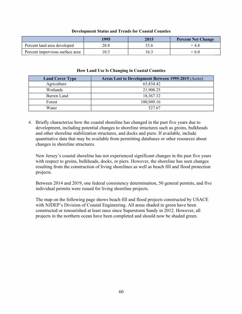
60
Development Status and Trends for Coastal Counties
1995 2015 Percent Net Change Percent land area developed 28.8 33.6 + 4.8 Percent impervious surface area 10.3 16.3 + 6.0
How Land Use Is Changing in Coastal Counties
Land Cover Type Areas Lost to Development Between 1995-2015 (Acres) Agriculture 65,834.42 Wetlands 21,908.25 Barren Land 18,367.32 Forest 100,949.16 Water 527.67
4. Briefly characterize how the coastal shoreline has changed in the past five years due to
development, including potential changes to shoreline structures such as groins, bulkheads and other shoreline stabilization structures, and docks and piers. If available, include quantitative data that may be available from permitting databases or other resources about changes in shoreline structures. New Jersey’s coastal shoreline has not experienced significant changes in the past five years with respect to groins, bulkheads, docks, or piers. However, the shoreline has seen changes resulting from the construction of living shorelines as well as beach fill and flood protection projects. Between 2014 and 2019, one federal consistency determination, 50 general permits, and five individual permits were issued for living shoreline projects. The map on the following page shows beach fill and flood projects constructed by USACE with NJDEP’s Division of Coastal Engineering. All areas shaded in green have been constructed or renourished at least once since Superstorm Sandy in 2012. However, all projects in the northern ocean have been completed and should now be shaded green.

61
5. Briefly summarize the results of any additional state- or territory-specific data or reports on the cumulative and secondary impacts of coastal growth and development, such as water quality, shoreline hardening, and habitat fragmentation, since the last assessment. Trends in the Quality of Water in New Jersey Streams, Water Years 1971–2011 This US Geological Survey report on water quality in New Jersey was released in 2016 and is located at https://pubs.usgs.gov/sir/2016/5176/sir20165176.pdf. The report found that levels of total nitrogen and phosphorus declined or stayed the same at most stream sites while

62
chlorides from road salt increased. For a synopsis of the findings, see https://www.usgs.gov/news/40-year-trend-study-finds-signs-improved-water-quality-new-jersey-streams-0. Integrated Water Quality Assessment, DEP New Jersey employs an integrated approach to assessing water quality by compiling a vast amount of water monitoring data and related information collected by numerous sources throughout the state and evaluating it to determine the health of New Jersey’s surface waters. This statewide assessment of water quality is conducted every two years and includes an intensive assessment of one of the five water regions each assessment cycle, which are assessed on a rotating basis. This rotating regional approach will produce a comprehensive assessment of the entire state every ten years based on the following schedule:
Water Region Integrated Report Atlantic Coastal 2014
Raritan 2016 Lower Delaware 2018 Upper Delaware 2020
Northeast 2022 Atlantic Coastal 2024
Each of the five regions covers a portion of New Jersey’s coastal zone. This integrated water quality assessment process is used to: determine if water quality conditions have changed over time, if water quality standards are met, and if designated uses, such as recreation and water supply, are fully supported; identify causes and sources of water quality impairment; and develop restoration strategies for impaired waters and protection strategies for healthy waters. New Jersey’s integrated water quality assessment process includes assessing if all freshwaters fully support the drinking water supply use but does not assess drinking water quality. The final 2014 Integrated Water Quality Assessment Report and the draft 2016 report can be found at https://www.nj.gov/dep/wms/bears/assessment.htm#/. The 2018 and 2020 reports are currently in progress. The report summarizes results of both short-term (5 years) and long-term (10+ years) water quality analysis. Long-term trends including ambient chemical data, macroinvertebrate data, and fish population studies provide a better indication of changes in water quality over time. The latest report's most significant trend has been the drastic decline of impaired waters caused by metals and ammonia throughout the state. Connecting Habitat Across New Jersey (CHANJ), DEP
The NJDEP’s Division of Fish and Wildlife has produced guidance and mapping to support a statewide habitat connectivity effort. The Connecting Habitat Across New Jersey (CHANJ)

63
project was developed by a multi-disciplinary working group consisting of over 40 different agencies across the state, including experts in science, policy, and communications. The project includes a strategic plan for wildlife conservation that identifies key areas and actions needed for preserving and restoring critical habitat linkages for terrestrial wildlife in New Jersey. The outcome of this effort was a statewide analysis depicting areas crucial for habitat connectivity as well as a menu of implementation actions relating to each identified wildlife corridor that will provide guidance on how to secure or restore each corridor, including mitigating the impacts of roads on wildlife and habitats. The CHANJ project has identified 815 habitat Cores across New Jersey, totaling 8,559 square kilometers in the state. Habitat corridors total 2,905 square kilometers. Together, the mapped Cores and Corridors comprise 57 percent of the state’s land area. Over a third of the connectivity network (habitat Cores and wildlife Corridors) is comprised of Terrestrial Wildlife Habitat (TWH) Preserved Land, which is permanently protected land that has terrestrial wildlife habitat value now and a high likelihood of being managed for wildlife conservation. The Piedmont region is by far the most fragmented and will be the greatest challenge for restoring and conserving connectivity across New Jersey. As this region divides the state between north and south, it is critical for connecting habitats for wildlife mobility. The long-term persistence of many species in the southern regions of the state is particularly dependent on functional connectivity to the northern regions as southern New Jersey is bounded by large water bodies (the Atlantic Ocean to the east and south and the Delaware Bay and Delaware River to the southwest). Across the state there are close to 7,000 kilometers of Road Segments (segments of roads within CHANJ Cores and Corridors) that are not adjacent to urbanization and serve as starting points for targeting road/wildlife mitigation efforts. So far, just 3 percent of the structures under roadways (e.g., culverts, bridges) have been inventoried and scored as to their predicted aquatic passability and none have been scored for terrestrial wildlife passability. However, there are 30 Road Wildlife Mitigation Projects across New Jersey (14 constructed and 16 in progress) designed to provide safe passage for terrestrial wildlife across roadways. For more detailed findings, visit https://www.njfishandwildlife.com/ensp/chanj.htm.
Management Characterization: 1. Indicate if the approach is employed by the state or territory and if there have been any
significant state-level changes (positive or negative) in the development and adoption of procedures to assess, consider, and control cumulative and secondary impacts of coastal growth and development, including the collective effect on various individual uses or activities on coastal resources, such as coastal wetlands and fishery resources, since the last assessment.
64
Significant Changes in Management of Cumulative and Secondary Impacts of Development
Management Category Employed by State
or Territory (Y or N)
CMP Provides Assistance to Locals
that Employ (Y or N)
Significant Changes Since Last Assessment
(Y or N) Statutes, regulations, policies, or case law interpreting these
Y Y Y
Guidance documents Y N Y Management plans (including SAMPs) Y Y Y
2. For any management categories with significant changes, briefly provide the information
below. If this information is provided under another enhancement area or section of the document, please provide a reference to the other section rather than duplicate the information:
a. Describe the significance of the changes; b. Specify if they were 309 or other CZM-driven changes; and c. Characterize the outcomes or likely future outcomes of the changes.
Statutes, regulations, policies, or case law
Amendments to Consolidate the Coastal Rules a. On July 6, 2015, the Coastal Permit Program Rules and the Coastal Zone Management
Rules were consolidated into one chapter (the CZM Rules) and amended to further encourage appropriate redevelopment of more resilient coastal communities following Superstorm Sandy. These amendments included modifying the scope of general permit 4 to apply to the development of one or two single-family homes or duplexes. In the NJDEP’s experience, applications for the construction of two dwelling units, usually associated with the subdivision of a single lot, are common. These lots are typically, but not always, small, bulkheaded lots located within existing residential back bay areas and of a size that would preclude intense waterfront developments such as marinas. Typically, these lots are already disturbed and, in some instances, may have an existing single-family home on the lot that will be replaced with two single-family homes. While impacts are associated with any development, the impacts associated with the construction of two single-family or duplex homes, when constructed in accordance with the standards of general permit 4, will be minimal. Amendments were also made to the shellfish habitat rule at N.J.A.C. 7:7-9.2 to allow the expansion of commercial marinas within shellfish habitat and the construction of new commercial marinas in infill situations in order to preserve existing commercial marina facilities, encourage new facilities, and ensure there are a sufficient number of boat slips available to the public. This provision is limited to legally existing, operating commercial marinas that are open to the general public for the mooring of vessels, including marinas operated by public agencies, commissions, and authorities. The intention of this provision is to limit the expansion of marinas into shellfish habitat to only those that are open to the

65
general public and not private operations such as condominium associations where membership is limited exclusively to condominium owners. Also under this rulemaking, a new special area rule was proposed for dredged material management areas at N.J.A.C. 7:7-9.49 to recognize that these areas are critical to facilitating maintenance and safe navigation of state and federal navigation channels and marinas. The failure to maintain navigational depths creates a hazard to all boating traffic and can impede growth of commercial and recreational activities in coastal communities or even result in reduction of those activities. Marinas are an essential component of the state’s waterfront communities as they provide necessary infrastructure and services to the boating public. Failure to maintain water depths at marinas may impede recreational boating opportunities. Finally, the marine fish and fisheries rule at N.J.A.C. 7:7-16.2 was amended to add the construction of a recreational dock or pier to the list of activities that are conditionally acceptable. Requiring docks and piers to be constructed in accordance with the recreational docks and piers rule at proposed N.J.A.C. 7:7-12.5 ensures that the impacts associated with the use of the dock, including impacts from turbidity, are minimized.
b. These changes were not 309 or CZM-driven.
c. Although these amendments were designed to foster redevelopment, the types of development authorized under these rules are associated with minimal cumulative and secondary impacts.
Amendments to the Coastal High Hazard Rule in the CZM Rules a. On January 16, 2018, amendments to the CZM Rules were adopted in response to issues
identified through stakeholder outreach and to address other issues that arose after the July 6, 2015 adoption of the consolidated coastal rules. As part of this rulemaking, amendments were made to N.J.A.C. 7:7-9.18, the coastal high hazard rule, to further promote consistency between the CZM Rules and other state and federal standards. These rule changes are described in the Phase I Assessment for the coastal hazards enhancement area.
b. These changes were not 309 or CZM-driven.
c. See the Phase I Assessment for coastal hazards.
Amendments to the FHACA Rules a. On July 17, 2017, amendments to the FHACA Rules were adopted to address certain
concerns raised through the public comment process for the amendments to the FHACA Rules that were adopted on June 20, 2016. As part of this rulemaking, amendments were made to strengthen standards for disturbance in a riparian zone, which is the land and vegetation within and adjacent to a regulated water, extending 50, 150, or 300 feet from

66
the top of bank along both sides of that water. Riparian zones are essential for mitigating the impacts from flooding. These amendments included changes to general permit-by-certification 6 for construction of one single-family home or duplex in a tidal flood hazard area to limit disturbance within a 50-foot riparian zone to no more than 3,500 square feet. In addition, within a 150-foot riparian zone, no disturbance can occur within 75 feet of any top of bank, and within a 300-foot riparian zone, no disturbance can be located within 150 feet of any top of bank. Similar amendments were made to general permit 6 for construction of one single-family home or duplex and one associated driveway that does not cross a regulated water. Rather than apply a uniform limit of 7,000 square feet of disturbance regardless of the width of the riparian zone, the NJDEP established a limit of 3,500 square feet of riparian zone disturbance within a 50-foot riparian zone and a limit of 7,000 square feet of disturbance within a 150-foot or 300-foot riparian zone. Additional amendments to this general permit limited disturbance in the inner 150-foot portion of a 300-foot riparian zone and the inner 75-foot portion of a 150-foot riparian zone. The rulemaking also included amendments to general permit 9 to limit the cumulative and secondary impacts resulting from the construction or reconstruction of a bridge or culvert across a regulated water with a drainage area of less than 50 acres. Any new bridge or culvert or any new railroad or roadway it conveys that is proposed to be located within a 300-foot riparian zone is no longer eligible for authorization under this general permit and may only be authorized under an individual permit, which may require mitigation as a condition of the permit. In addition, the total area of riparian zone vegetation to be cleared, cut, and/or removed may not exceed the limits set forth in Table 11.2, which is included in the section on requirements for a regulated activity in a riparian zone at N.J.A.C. 7:13-11.2. The limit of riparian disturbance under the table depends on whether the bridge or culvert is new construction or reconstruction, and whether it is conveying a public roadway or railroad, a private driveway, or any other roadway. N.J.A.C. 7:13-11.2 was also amended to establish additional protections for the inner 150 feet of a 300-foot riparian zone, which is essential for maintaining water quality, ecological health, and fisheries resources associated with Category One waters. Under these amendments, an applicant must demonstrate that the project is in the public interest. All other projects must be located outside of the inner 150-foot portion of the 300-foot riparian zone. Also, mitigation must be provided for all impacts within a 300-foot riparian zone under an individual permit. NJDEP also restricted the amount of riparian zone disturbance that may be exempt under N.J.A.C. 7:13-11.2(f)6 to less than one acre in order to ensure that the benefits and functions of the riparian zone are not diminished through regulated activities associated with public roadways. Finally, the CZM Rules were also amended under this rulemaking for consistency with the new riparian zone standards in the FHACA Rules.
b. These changes were not 309 or CZM-driven.

67
c. These amendments are expected to reduce the amount of vegetation that is disturbed within riparian zones, thereby minimizing flooding and other secondary and cumulative impacts, such as a reduction in water quality, associated with development within these environmentally sensitive areas.
Guidance Documents Land Use/Land Cover Data Update a. This data is intended to serve as a resource data set. The 2015 LU/LC data set is the sixth
in a series of land use mapping efforts that began in 1986. In subsequent years, revisions and additions were made to the initial baseline layer from imagery captured in 1995/97, 2002, 2007, and 2012. The 2015 update was created by comparing the 2012 LU/LC layer from NJDEP's Geographical Information Systems (GIS) database to the 2015 color infrared imagery and by delineating and coding areas of change. LU/LC changes were captured by adding new line work and attribute data for the 2015 land use directly to the base data layer. All 2012 LU/LC polygons and attribute fields remain in this data set so change analysis for the period 2012-2015 can be undertaken from this one layer.
b. These changes were not 309 or CZM-driven.
c. The use of the updated 2015 LU/LC data in land use analyses will provide an enhanced means of monitoring cumulative and secondary impacts and the ecosystems of New Jersey through the use of diverse applications. The data set will provide information for regulators, planners, and others interested in LU/LC changes and will allow them to quantify those changes over time using GIS.
Sustainable and Resilient Coastal Communities Project Report a. The Sustainable and Resiient Coastal Communities project is described in the Phase I
Assessment for the coastal hazards enhancement area.
b. This project was 309-driven.
c. The final report for the project included recommendations for planning actions as well as considerations for amendments to the CZM Rules. Section 5f of this report contained the evaluation of cumulative and secondary impacts, which included environmentally sensitive areas, impervious surface, water quality, marsh migration, and proximity to hazards. The final report is available at https://www.njfuture.org/wp-content/uploads/2017/12/New-Jersey-Future-Resilient-Coastal-Communities-Project-Report-2017.pdf.
New Jersey Landscape Project a. Designed to guide strategic wildlife habitat conservation, the Landscape Project is a pro-
active, ecosystem-level approach for the long-term protection of imperiled species and

68
their important habitats in New Jersey. Its goal is to protect New Jersey's biological diversity by maintaining and enhancing imperiled wildlife populations within healthy, functioning ecosystems. NJDEP’s Division of Fish and Wildlife's Endangered and Nongame Species Program began the project in 1994 but launched an updated version, version 3.3, in 2017. The previous version of the Landscape Project was based on species occurrence data collected prior to 2012 and habitat data derived from 2007 Land Use/Land Cover (LU/LC). However, since that version was launched, more than 3,400 new species occurrence records were added to New Jersey’s Biotics database, and habitat data was updated to reflect the most recent LU/LC. In addition, the new version incorporates species not previously represented in the Landscape Project, including Atlantic sturgeon and northern long-eared bat (northern myotis). Version 3.3 of the Landscape Project applies a methodology to the entire state that includes precise methods for delineating habitat based on species-specific habitat associations. In addition to providing access to a list of species that occur in an area of interest defined by a user, Version 3.3 provides detailed information, including the type of occurrence, or feature label (e.g., colony, den, nest, foraging, etc.), and the last recorded year of occurrence. Finally, Version 3.3 also features easily accessible documentation that includes transparent descriptions of the methods used and references to supporting scientific literature. The Landscape Project can be accessed at https://www.state.nj.us/dep/fgw/ensp/landscape/index.htm.
b. These changes were not 309 or CZM-driven.
c. The Landscape Project is used to inform New Jersey’s planning processes to protect threatened and endangered species habitat, including through the Plan Endorsement process, described below.
Flood Hazard Area Technical Manual a. In January 2018, the NJDEP released an updated version of the technical manual for the
Flood Hazard Area Control Act Rules. The purpose of this manual, which is one of a series of technical manuals produced by the Department in accordance with N.J.S.A. 13:1D-111 et seq., is to assist applicants in obtaining any approvals that may be necessary for an activity under the jurisdiction of the FHACA Rules. The material presented in the manual is intended to explain the standards of the rules and to provide guidance on how to meet those standards.
b. These changes were not 309 or CZM-driven.
c. The Flood Hazard Area Technical Manual is a useful tool to help the interested public understand the complex FHACA Rules and to assist potential applicants with preparing applications.
69
Management Plans New Jersey State Development and Redevelopment Plan – Plan Endorsement
a. The New Jersey State Development and Redevelopment Plan (State Plan), adopted in 2001, was designed to provide guidance on where growth should be targeted in the state and where preservation should be prioritized in order to limit sprawl and promote other smart growth strategies. Within the coastal zone, CAFRA places limits on the impervious cover allowed in different areas in coordination with the State Plan. Municipalities may seek to have their plans endorsed by the State Planning Commission, signifying that those plans are in alignment with the state plan. Through the plan endorsement process, municipalities may have sections of their communities redesignated into higher or lower growth areas, affecting the amount of impermeable cover that is allowed. This includes the establishment of centers, cores, and nodes where development is intended to be concentrated. Cumulative and secondary impacts are addressed through this plan endorsement process.
In the past five years, the townships of Toms River, Lakewood, and Lacey, along with
the Eagleswood Airport node, successfully completed the plan endorsement process. The process has also gone through programmatic changes to improve the resilience of communities. Lacey Township, the most recent town to go through plan endorsement, was required to remove all centers and all proposed affordable housing from their floodplain.
At the December 4, 2019 State Planning Commission meeting, plans were announced to further improve the plan endorsement process, including NJDEP mapping of new resilient center boundaries and criteria for local resilience strategies for the 60 communities working with New Jersey’s Office of Planning Advocacy to reestablish centers before they expire at the end of June 2020. NJDEP proposed this change, anticipating that not all 60 communities would make it through the plan endorsement process by June. The centers can be extended if the State Planning Commission, including NJDEP, agrees that significant progress has been made in the development and implementation of an action plan and plan implementation agreement. To determine if significant progress has been made, the NJDEP will be looking for identification of new resilient boundaries for centers and agreement that a community will create and begin to implement a local resilience strategy. NJDEP has developed interim guidance that outlines how municipalities should evaluate and address local climate change impacts during Plan Endorsement. This interim guidance is currently being revised and improved.
b. These changes were not 309 or CZM-driven. c. In 2020, over 90 centers are set to expire across New Jersey, including over 30 in the
coastal zone. Many of these municipalities have started the plan endorsement process for reapproval of their centers. This represents an important opportunity for new discussions with municipalities about the most appropriate locations for development and which areas should be preserved.

70
Enhancement Area Prioritization: 1. What level of priority is the enhancement area for the coastal management program?
High ______ Medium __X__ Low ______
2. Briefly explain the reason for this level of priority. Include input from stakeholder
engagement, including the types of stakeholders engaged.
According to the NJCMP’s survey (described in further detail in the Summary of Stakeholder and Public Comment section of this document), 63.2 percent of respondents have been involved with projects associated with cumulative and secondary impacts over the past five years. The surveyed stakeholders identified cumulative and secondary impacts as one of their top priority enhancement areas. However, cumulative and secondary impacts intersect with other enhancement areas and will be addressed in strategies developed for the wetlands, coastal hazards, public access, and oceans and Great Lakes resources enhancement areas. For this reason, the NJCMP has ranked cumulative and secondary impacts as a medium priority.

71
Special Area Management Planning
Section 309 Enhancement Objective: Preparing and implementing special area management plans for important coastal areas. §309(a)(6) The Coastal Zone Management Act defines a special area management plan (SAMP) as “a comprehensive plan providing for natural resource protection and reasonable coastal-dependent economic growth containing a detailed and comprehensive statement of policies; standards and criteria to guide public and private uses of lands and waters; and mechanisms for timely implementation in specific geographic areas within the coastal zone. In addition, SAMPs provide for increased specificity in protecting natural resources, reasonable coastal-dependent economic growth, improved protection of life and property in hazardous areas, including those areas likely to be affected by land subsidence, sea level rise, or fluctuating water levels of the Great Lakes, and improved predictability in governmental decision making.” PHASE I (HIGH-LEVEL) ASSESSMENT: (Must be completed by all states and territories.) Purpose: To quickly determine whether the enhancement area is a high-priority enhancement objective for the CMP that warrants a more in-depth assessment. The more in-depth assessments of Phase II will help the CMP understand key problems and opportunities that exist for program enhancement and determine the effectiveness of existing management efforts to address those problems. Resource Characterization: 1. In the table below, identify geographic areas in the coastal zone subject to use conflicts that
may be able to be addressed through a SAMP. This can include areas that are already covered by a SAMP but where new issues or conflicts have emerged that are not addressed through the current SAMP.
Geographic Area Opportunities for New or Updated Special Area Management Plans Major conflicts/issues
Hudson River, NY/NJ Harbor Estuary
Contamination, excess levels of nutrients, legacy toxic pollution, marine debris
Barnegat Bay Estuary Submerged aquatic vegetation, coastal wetland erosion, derelict fishing gear, development
Delaware River Estuary Nutrients/pollution, clean water, wetland loss, forest loss, fish and shellfish habitat
2. If available, briefly list and summarize the results of any additional state- or territory-specific
data or reports on the status and trends of SAMPs since the last assessment.
72
Although New Jersey does not currently have any SAMPs, each of the three geographic areas listed in the chart above are part of the National Estuary Program, which is “a collaborative, efficient, and adaptable ecosystem-based network of organizations that protects and restores 28 estuaries of national significance.” Each of the 28 National Estuary Programs (NEPs) must develop and implement a Comprehensive Conservation and Management Plan (CCMP) to prioritize activities, research, and funding for the estuary and to address environmental protection issues, such as water quality, habitat, fish and wildlife, pathogens, land use, and introduced species. Each CCMP is based on a scientific characterization of the specific estuary. In addition to the NEP programs, the NJDEP developed its own comprehensive action plan to address the ecological health of the Barnegat Bay watershed. Hudson River, New York/New Jersey Harbor Estuary The NEP for the Hudson River and New York/New Jersey Harbor Estuary area is the New York/New Jersey Harbor Estuary Program (HEP). The HEP has developed an Action Agenda for 2017-2022 that provides five long-term goals, 17 specific objectives, and 40 actions to address cleaner water, restored fish and wildlife habitat, improved public access, more efficient maritime activities, and robust community engagement. The Action Agenda is available at https://www.hudsonriver.org/NYNJHEPActionAgenda.pdf. Other core planning documents for the HEP can be found at https://www.hudsonriver.org/article/core-hep-documents. Barnegat Bay Estuary The NEP for the Barnegat Bay estuary is the Barnegat Bay Partnership (BBP). The goals of the BBP are to help restore, protect, and enhance the water quality and natural resources of the Barnegat Bay and its watershed. The BBP’s Barnegat Bay Comprehensive Conservation and Management Plan (CCMP) was approved in 2002 but is currently being revised to reflect the changes in the bay’s condition and to plan for emerging stressors, including climate change and sea level rise. The revised plan focuses on water quality, water supply, living resources, and land use. The draft is available at https://www.barnegatbaypartnership.org/about-us/ccmp/. The NJDEP also continues to develop and implement its own comprehensive action plan for the ecological health of the Barnegat Bay watershed, which was established on December 9, 2010. The original plan, the Ten-Point Plan, included scientific research, water quality monitoring and analysis, implementation of stewardship projects, stormwater management efforts, and purchasing of important lands for open space protection. However, in October 2017, the NJDEP released phase two of this plan – The Barnegat Bay Restoration, Enhancement, and Protection Strategy (BB REP Strategy), which is built upon the data, modeling results, and research generated by the Ten-Point Plan and includes short-term, mid-term, and long-term objectives and actions aimed at restoring areas of concern (Restoration), enhancing areas wherever possible (Enhancement), and protecting healthy areas (Protection) of the Barnegat Bay. The strategy also includes monitoring activities throughout the process

73
to assess the strategy’s effect on water quality and biodiversity (Assessment). The BB REP is available at https://www.nj.gov/dep/barnegatbay/docs/BarnBay-REPS.pdf. Delaware River Estuary The NEP for the Delaware River estuary is the Partnership for the Delaware Estuary (PDE). The goal of the PDE is to bring together people, businesses, and governments to restore and protect the Delaware River and Bay. The PDE’s Comprehensive Conservation and Management Plan (CCMP) was originally approved in 1996 but was revised in 2019 to establish a revised set of goals and strategies for achieving and tracking improvements to the health of the Delaware Estuary. The revised plan focuses on clean waters, healthy habitats, and strong communities. The draft is available at https://s3.amazonaws.com/delawareestuary/2019+DelEst+Revised+CCMP.pdf.
Management Characterization: 1. Indicate if the approach is employed by the state or territory and if there has been any
significant state- or territory-level management changes (positive or negative) that could help prepare and implement SAMPs in the coastal zone.
Significant Changes in Special Area Management Planning
Management Category Employed by
State or Territory (Y or N)
CMP Provides Assistance to Locals
that Employ (Y or N)
Significant Changes Since Last Assessment
(Y or N)
SAMP policies, or case law interpreting these N N N
SAMP plans N N N
2. For any management categories with significant changes, briefly provide the information below.
If this information is provided under another enhancement area or section of the document, please provide a reference to the other section rather than duplicate the information:
a. Describe the significance of the changes; b. Specify if they were 309 or other CZM-driven changes; and c. Characterize the outcomes or likely future outcomes of the changes.
New Jersey does not currently have any Special Area Management Plans.
Enhancement Area Prioritization: 1. What level of priority is the enhancement area for the coastal management program?
High ______ Medium ______ Low __X__
74
2. Briefly explain the reason for this level of priority. Include input from stakeholder engagement, including the types of stakeholders engaged.
According to the NJCMP’s survey (described in further detail in the Summary of Stakeholder and Public Comment section of this document), only 2.6 percent of respondents have been involved with SAMPs over the past five years. Furthermore, the surveyed stakeholders ranked SAMPs as one of their lower priority enhancement areas. The development of a SAMP also remains a low priority for the NJCMP at this time due to more critical issues and needs. However, the NJDEP is utilizing various tools and implementing numerous rules and policies that will benefit all of the waterbodies throughout the coastal zone.
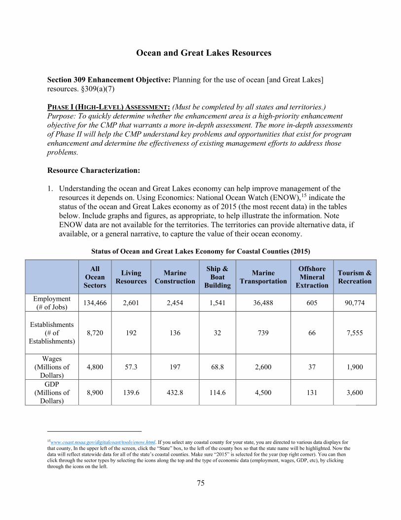
75
Ocean and Great Lakes Resources
Section 309 Enhancement Objective: Planning for the use of ocean [and Great Lakes] resources. §309(a)(7) PHASE I (HIGH-LEVEL) ASSESSMENT: (Must be completed by all states and territories.) Purpose: To quickly determine whether the enhancement area is a high-priority enhancement objective for the CMP that warrants a more in-depth assessment. The more in-depth assessments of Phase II will help the CMP understand key problems and opportunities that exist for program enhancement and determine the effectiveness of existing management efforts to address those problems. Resource Characterization: 1. Understanding the ocean and Great Lakes economy can help improve management of the
resources it depends on. Using Economics: National Ocean Watch (ENOW),15 indicate the status of the ocean and Great Lakes economy as of 2015 (the most recent data) in the tables below. Include graphs and figures, as appropriate, to help illustrate the information. Note ENOW data are not available for the territories. The territories can provide alternative data, if available, or a general narrative, to capture the value of their ocean economy.
Status of Ocean and Great Lakes Economy for Coastal Counties (2015)
All Ocean Sectors
Living Resources
Marine Construction
Ship & Boat
Building
Marine Transportation
Offshore Mineral
Extraction
Tourism & Recreation
Employment (# of Jobs) 134,466 2,601 2,454 1,541 36,488 605 90,774
Establishments (# of
Establishments) 8,720 192 136 32 739 66 7,555
Wages (Millions of
Dollars) 4,800 57.3 197 68.8 2,600 37 1,900
GDP (Millions of
Dollars) 8,900 139.6 432.8 114.6 4,500 131 3,600
15www.coast.noaa.gov/digitalcoast/tools/enow.html. If you select any coastal county for your state, you are directed to various data displays for that county, In the upper left of the screen, click the “State” box, to the left of the county box so that the state name will be highlighted. Now the data will reflect statewide data for all of the state’s coastal counties. Make sure “2015” is selected for the year (top right corner). You can then click through the sector types by selecting the icons along the top and the type of economic data (employment, wages, GDP, etc), by clicking through the icons on the left.
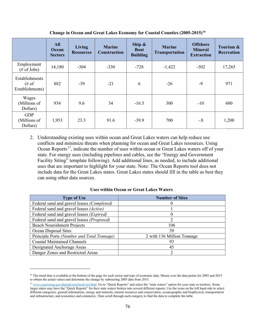
76
Change in Ocean and Great Lakes Economy for Coastal Counties (2005-2015)16
All
Ocean Sectors
Living Resources
Marine Construction
Ship & Boat
Building
Marine Transportation
Offshore Mineral
Extraction
Tourism & Recreation
Employment (# of Jobs) 14,180 -304 -330 -728 -1,422 -302 17,265
Establishments (# of
Establishments) 882 -39 -21 6 -26 -9 971
Wages (Millions of
Dollars) 934 9.6 34 -16.5 300 -10 600
GDP (Millions of
Dollars) 1,953 23.3 91.6 -39.9 700 -.8 1,200
2. Understanding existing uses within ocean and Great Lakes waters can help reduce use
conflicts and minimize threats when planning for ocean and Great Lakes resources. Using Ocean Reports17, indicate the number of uses within ocean or Great Lakes waters off of your state. For energy uses (including pipelines and cables, see the “Energy and Government Facility Siting” template following). Add additional lines, as needed, to include additional uses that are important to highlight for your state. Note: The Ocean Reports tool does not include data for the Great Lakes states. Great Lakes states should fill in the table as best they can using other data sources.
Uses within Ocean or Great Lakes Waters
Type of Use Number of Sites Federal sand and gravel leases (Completed) 0 Federal sand and gravel leases (Active) 1 Federal sand and gravel leases (Expired) 0 Federal sand and gravel leases (Proposed) 2 Beach Nourishment Projects 106 Ocean Disposal Sites 39 Principle Ports (Number and Total Tonnage) 2 with 136 Million Tonnage Coastal Maintained Channels 93 Designated Anchorage Areas 45 Danger Zones and Restricted Areas 2
16 The trend data is available at the bottom of the page for each sector and type of economic data. Mouse over the data points for 2005 and 2015 to obtain the actual values and determine the change by subtracting 2005 data from 2015. 17 www.coast.noaa.gov/digitalcoast/tools/ort.html. Go to “Quick Reports” and select the “state waters” option for your state or territory. Some larger states may have the “Quick Reports” for their state waters broken into several different reports. Use the icons on the left hand side to select different categories: general information, energy and minerals, natural resources and conservation, oceanographic and biophysical, transportation and infrastructure, and economics and commerce. Then scroll through each category to find the data to complete the table.

77
3. In the table below, characterize how the threats to and use conflicts over ocean and Great Lakes resources in the state’s or territory’s coastal zone have changed since the last assessment.
Significant Changes to Ocean and Great Lakes Resources and Uses
Resource/Use Change in the Threat to the Resource or Use
Conflict Since Last Assessment (↑, ↓, -, unkwn)
Benthic habitat (including coral reefs) - Living marine resources (fish, shellfish, marine mammals, birds, etc.) -
Sand/gravel - Cultural/historic - Other (please specify) - Transportation/navigation - Offshore development18 ↑ Energy production ↑ Fishing (commercial and recreational) ↑ Recreation/tourism - Sand/gravel extraction - Dredge disposal - Aquaculture -
4. For the ocean and Great Lakes resources and uses in the table above that had an increase in threat to the resource or increased use conflict in the state’s or territory’s coastal zone since the last assessment, characterize the major contributors to that increase. Place an “X” in the column if the use or phenomenon is a major contributor to the increase.
Major Contributors to an Increase in Threat or Use Conflict to Ocean
and Great Lakes Resources
Land
-bas
ed
deve
lopm
ent
Off
shor
e de
velo
pmen
t
Pollu
ted
runo
ff
Inva
sive
spec
ies
Fish
ing
(Com
m
and
Rec
)
Aqu
acul
ture
Rec
reat
ion
Mar
ine
Tran
spor
tatio
n
Dre
dgin
g
Sand
/Min
eral
Ex
tract
ion
Oce
an
Aci
dific
atio
n
Offshore development X X X X X Energy production X X X X Fishing (commercial and recreational) X X X X X X X
18 Offshore development includes underwater cables and pipelines, although any infrastructure specifically associated with the energy industry should be captured under the “energy production” category.

78
5. If available, briefly list and summarize the results of any additional state- or territory-specific data or reports on the status and trends of ocean and Great Lakes resources or threats to those resources since the last assessment to augment the national data sets. No state-specific data or reports are currently available regarding status and trends of ocean resources or threats to those resources.
Management Characterization: 1. Indicate if the approach is employed by the state or territory and if any significant state- or
territory-level changes (positive or negative) in the management of ocean and Great Lakes resources have occurred since the last assessment?
Significant Changes to Management of Ocean and Great Lakes Resources
Management Category Employed by
State or Territory (Y or N)
CMP Provides Assistance to Locals
that Employ (Y or N)
Significant Changes Since Last Assessment
(Y or N)
Statutes, regulations, policies, or case law interpreting these
Y N N
Regional comprehensive ocean/Great Lakes management plans
Y N Y
State comprehensive ocean/Great Lakes management plans
N N N
Single-sector management plans N N N
2. For any management categories with significant changes, briefly provide the information below.
If this information is provided under another enhancement area or section of the document, please provide a reference to the other section rather than duplicate the information:
a. Describe the significance of the changes; b. Specify if they were 309 or other CZM-driven changes; and c. Characterize the outcomes or likely future outcomes of the changes.
Regional comprehensive ocean management plans
a. The Mid-Atlantic Regional Council on the Ocean (MARCO) was created by the
governors of New York, New Jersey, Delaware, Maryland, and Virginia in June 2009. The agreement between the states established guiding principles as the foundation for collaboration and four initial priorities for shared action:
1. Coordinate protection of important habitats and sensitive and unique offshore areas on a regional scale;

79
2. Promote improvements in the region’s coastal water quality; 3. Collaborate on a regional approach to support the sustainable development of
renewable energy in offshore areas; and 4. Prepare the region’s coastal communities for the impacts of climate change on
ocean and coastal resources.
The agreement also called for working with stakeholders to create new partnerships in the development and implementation of these actions. The participating states developed an action plan entitled “Actions, Timelines, and Leadership to Advance the Mid-Atlantic Governors’ Agreement on Ocean Conservation” that includes a problem statement for each of the four priorities as well as goals, objectives, and initial actions towards meeting those goals. In 2010, Presidential Executive Order 13547 established a National Ocean Policy (NOP) to guide the protection, maintenance, and restoration of America’s oceans and coasts, which called for the creation of Regional Planning Bodies (RPBs) to coordinate and implement regional ocean planning with state, federal, tribal, and fishery management council representatives. The Mid-Atlantic RPB began developing an Ocean Action Plan in 2013 that established eleven overarching principles to guide ocean planning, two goals for the regional ocean planning process (healthy ocean ecosystems and sustainable ocean uses), and a series of objectives related to each goal. With the finalization of the Ocean Action Plan in December 2016, the RPB entered the implementation phase for almost 40 actions through the formation of workgroups across the various objectives under the two goals. However, on June 19, 2018, President Trump revoked the RPBs through Executive Order 13840. Despite this, MARCO, as the regional ocean partnership for the mid-Atlantic, continues to work on issues outlined through the RPB and the Ocean Action Plan as many of these issues are priorities for the MARCO states. In 2019, to engage the diverse interests in the region and enhance the vitality of the region’s ocean ecosystem and economy, the MARCO states and a partnership of federal agencies, tribal entities, and the Mid-Atlantic Fishery Management Council formed the Mid-Atlantic Committee on the Ocean (MACO). MACO will coordinate across the region on ocean and coastal issues. NJCMP staff are responsible for the day to day coordination of both MARCO and MACO actions and program development and currently serve as MACO’s chair while co-leading MACO’s Offshore Wind workgroup and Non-Consumptive Recreational Use Workgroup and participating in many other workgroups. New Jersey is currently working with other MARCO states and federal agencies through MACO to identify new workgroups related to sand management and regional resiliency to ensure New Jersey’s interests are considered in these endeavors. MACO will leverage the current efforts being undertaken by states and regional entities as well as engage stakeholders and technical experts.
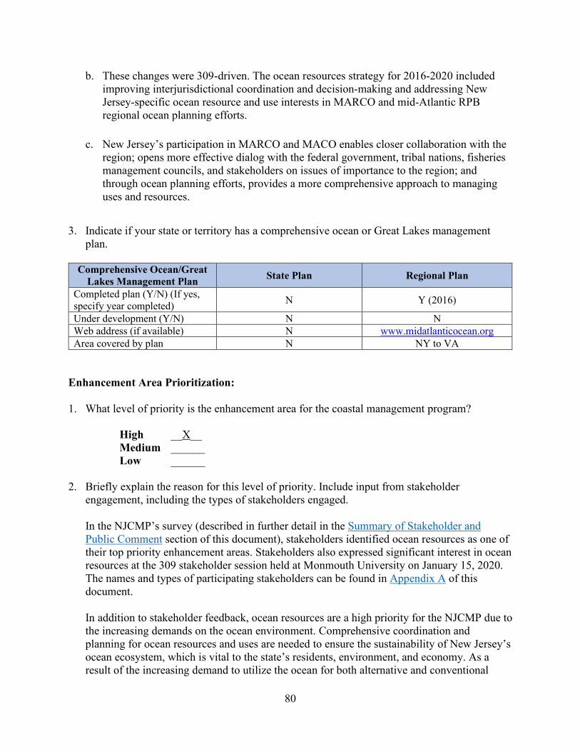
80
b. These changes were 309-driven. The ocean resources strategy for 2016-2020 included improving interjurisdictional coordination and decision-making and addressing New Jersey-specific ocean resource and use interests in MARCO and mid-Atlantic RPB regional ocean planning efforts.
c. New Jersey’s participation in MARCO and MACO enables closer collaboration with the region; opens more effective dialog with the federal government, tribal nations, fisheries management councils, and stakeholders on issues of importance to the region; and through ocean planning efforts, provides a more comprehensive approach to managing uses and resources.
3. Indicate if your state or territory has a comprehensive ocean or Great Lakes management plan.
Comprehensive Ocean/Great
Lakes Management Plan State Plan Regional Plan
Completed plan (Y/N) (If yes, specify year completed) N Y (2016)
Under development (Y/N) N N Web address (if available) N www.midatlanticocean.org Area covered by plan N NY to VA
Enhancement Area Prioritization: 1. What level of priority is the enhancement area for the coastal management program?
High __X__ Medium ______ Low ______
2. Briefly explain the reason for this level of priority. Include input from stakeholder
engagement, including the types of stakeholders engaged.
In the NJCMP’s survey (described in further detail in the Summary of Stakeholder and Public Comment section of this document), stakeholders identified ocean resources as one of their top priority enhancement areas. Stakeholders also expressed significant interest in ocean resources at the 309 stakeholder session held at Monmouth University on January 15, 2020. The names and types of participating stakeholders can be found in Appendix A of this document. In addition to stakeholder feedback, ocean resources are a high priority for the NJCMP due to the increasing demands on the ocean environment. Comprehensive coordination and planning for ocean resources and uses are needed to ensure the sustainability of New Jersey’s ocean ecosystem, which is vital to the state’s residents, environment, and economy. As a result of the increasing demand to utilize the ocean for both alternative and conventional

81
energy, coupled with the need for better management of existing uses and resources, the NJCMP must continue to focus attention on ocean resources management, including the continuation of efforts with MARCO, MACO, and federal agencies to advance ocean planning and increased coordination with academic institutions and other relevant non-government organizations.
82
Energy and Government Facility Siting
Section 309 Enhancement Objective: Adoption of procedures and enforceable policies to help facilitate the siting of energy facilities and Government facilities and energy-related activities and Government activities which may be of greater than local significance. §309(a)(8)19 PHASE I (HIGH-LEVEL) ASSESSMENT: (Must be completed by all states and territories.) Purpose: To quickly determine whether the enhancement area is a high-priority enhancement objective for the CMP that warrants a more in-depth assessment. The more in-depth assessments of Phase II will help the CMP understand key problems and opportunities that exist for program enhancement and determine the effectiveness of existing management efforts to address those problems. Resource Characterization: 1. In the table below, characterize the status and trends of different types of energy facilities and
activities in the state’s or territory’s coastal zone based on best-available data. If available, identify the approximate number of facilities by type. For ocean-facing states and territories (not Great Lakes states), Ocean Reports20 includes existing data for many of these energy facilities and activities.
19 CZMA § 309(a)(8) is derived from program approval requirements in CZMA § 306(d)(8), which states:
“The management program provides for adequate consideration of the national interest involved in planning for, and managing the coastal zone, including the siting of facilities such as energy facilities which are of greater than local significance. In the case of energy facilities, the Secretary shall find that the State has given consideration to any applicable national or interstate energy plan or program.”
NOAA regulations at 15 C.F.R. § 923.52 further describe what states need to do regarding national interest and consideration of interests that are greater than local interests. 20 www.coast.noaa.gov/digitalcoast/tools/ort.html. Select “Quick Reports” and then enter your state. Select the Quick Reports for “coastal waters” off of your state. Depending on the size of the state, there may be more than one “coastal waters”. If so, you will need to add the data from all reports to complete the table. Click on the wind turbine icon on the left (“Energy and Minerals”) for information on energy facilities. While outside your coastal zone, you may also want to consider facilities/activities in “Federal Waters” that may have effects on your coastal zone.
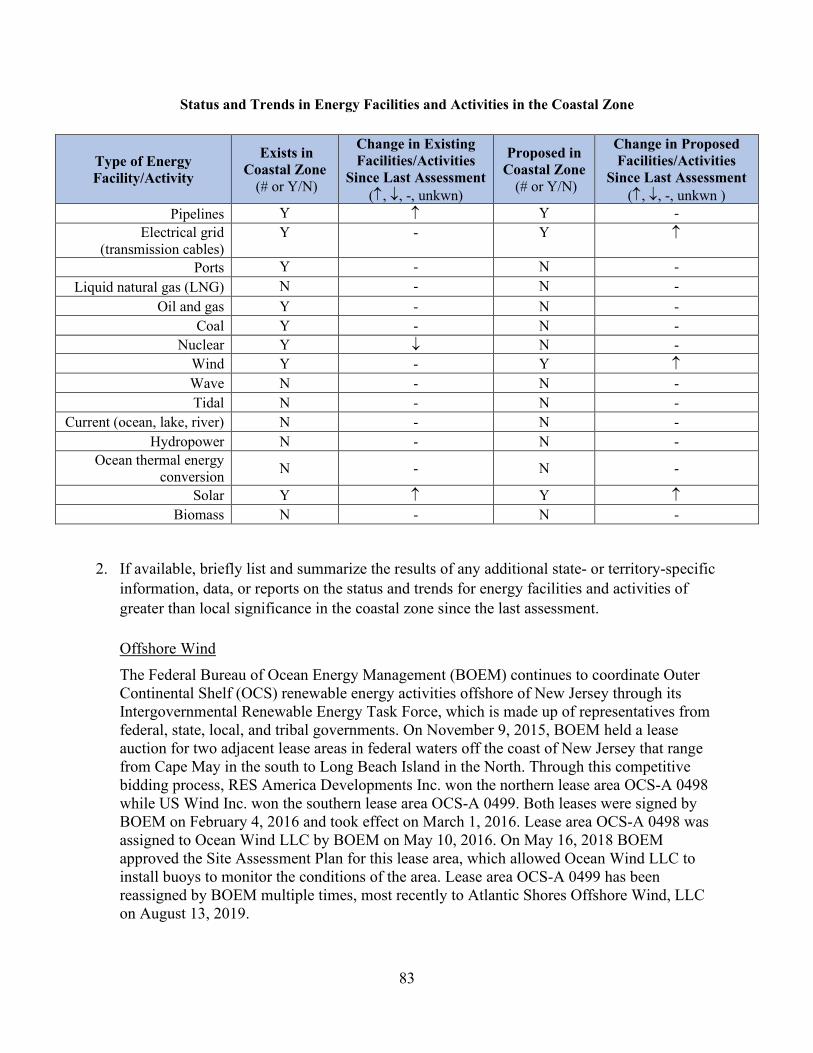
83
Status and Trends in Energy Facilities and Activities in the Coastal Zone
2. If available, briefly list and summarize the results of any additional state- or territory-specific
information, data, or reports on the status and trends for energy facilities and activities of greater than local significance in the coastal zone since the last assessment. Offshore Wind The Federal Bureau of Ocean Energy Management (BOEM) continues to coordinate Outer Continental Shelf (OCS) renewable energy activities offshore of New Jersey through its Intergovernmental Renewable Energy Task Force, which is made up of representatives from federal, state, local, and tribal governments. On November 9, 2015, BOEM held a lease auction for two adjacent lease areas in federal waters off the coast of New Jersey that range from Cape May in the south to Long Beach Island in the North. Through this competitive bidding process, RES America Developments Inc. won the northern lease area OCS-A 0498 while US Wind Inc. won the southern lease area OCS-A 0499. Both leases were signed by BOEM on February 4, 2016 and took effect on March 1, 2016. Lease area OCS-A 0498 was assigned to Ocean Wind LLC by BOEM on May 10, 2016. On May 16, 2018 BOEM approved the Site Assessment Plan for this lease area, which allowed Ocean Wind LLC to install buoys to monitor the conditions of the area. Lease area OCS-A 0499 has been reassigned by BOEM multiple times, most recently to Atlantic Shores Offshore Wind, LLC on August 13, 2019.
Type of Energy Facility/Activity
Exists in Coastal Zone
(# or Y/N)
Change in Existing Facilities/Activities
Since Last Assessment (↑, ↓, -, unkwn)
Proposed in Coastal Zone
(# or Y/N)
Change in Proposed Facilities/Activities
Since Last Assessment (↑, ↓, -, unkwn )
Pipelines Y ↑ Y - Electrical grid
(transmission cables) Y - Y ↑
Ports Y - N - Liquid natural gas (LNG) N - N -
Oil and gas Y - N - Coal Y - N -
Nuclear Y ↓ N - Wind Y - Y ↑ Wave N - N - Tidal N - N -
Current (ocean, lake, river) N - N - Hydropower N - N -
Ocean thermal energy conversion N - N -
Solar Y ↑ Y ↑ Biomass N - N -
84
New Jersey has recently begun to prioritize offshore wind development as part of the necessary next steps following Governor Murphy’s signing of Executive Order No. 28 on May 23, 2018, which required the development of a statewide clean energy plan to transition New Jersey away from energy production that contributes to climate change. On November 19, 2019, the governor signed Executive Order No. 92 establishing an offshore wind energy goal of 7,500 megawatts by the year 2035. New Jersey’s current Energy Master Plan (EMP) was released on January 27, 2020 and includes seven strategies to reach the administration’s goal of 100 percent clean energy by 2050. As part of the release of this master plan, Governor Murphy signed Executive Order No. 100, which orders the adoption of regulations under the New Jersey Protecting Against Climate Threats (PACT) initiative to reduce emissions and adapt to climate change. The development of offshore wind energy is a major component to reducing emissions. NJ PACT will also integrate climate change considerations into the regulatory and permitting processes of the NJDEP to protect communities from future climate change related damages. The NJDEP is holding stakeholder meetings in 2020 to solicit feedback for possible rule changes. Amendments to the CZM Rules, FWPA Rules, FHACA Rules, and Stormwater Management Rules, including amendments to facilitate offshore wind development, are projected to be adopted by fall/winter of 2021. Onshore Wind New Jersey currently has only two significant onshore wind farms – the Jersey-Atlantic Wind Farm and the Bayonne Wind Project. The Jersey-Atlantic Wind Farm, located at the Atlantic County Utilities Authority wastewater treatment plant in Atlantic City, has been in operation since 2005 and contains five turbines that produce a combined 7.5 megawatts of power. The Bayonne Wind Project, located in Bayonne, Hudson County, has been in operation since 2012 and contains one turbine that currently produces 1,500 kilowatts of power. A third onshore windfarm in Ocean Gate, New Jersey was shut down in October 2019 after one of its two wind turbines lost a blade. No additional onshore wind farm projects have been proposed since the previous 309 assessment as offshore wind development is considered more appropriate for state power production due to insufficient onshore wind velocity in New Jersey. Solar Currently, more than 3.2 gigawatts of power are generated in New Jersey from over 123,000 Solar Photovoltaic panel installations. However, solar power production is expected to increase. On May 23, 2018, Governor Murphy signed the Clean Energy Act (P.L.2018, c.17) to transition New Jersey away from energy production that contributes to climate change. The act included the establishment of the three-year Community Solar Energy Pilot Program to allow utility customers to purchase a subscription in a community solar energy project that is remotely located from their property. Participants will receive a credit towards their utility bill. On December 20, 2019, conditional approvals were granted to 45 communities to participate in the program.
85
Pipelines The Federal Energy Regulatory Commission (FERC) approved nine pipeline projects in New Jersey between 2016 and 2019. The projects range from 0.20 to 118.1 miles of pipeline. The NJDEP continues to review pipelines on a project-by-project basis for compliance with the appropriate statutes and implementing regulations. Nuclear At the time of the previous Section 309 Assessment and Strategy, New Jersey had three nuclear power plants. However, the state began shutting down the Oyster Creek plant in 2018, and fuel has been removed from the reactor. The estimated date for complete closure of the facility is 2035. The Salem and Hope Creek nuclear power plants remain active. At this time, no additional nuclear facilities are proposed as New Jersey is looking to transition to renewable clean energy sources, such as offshore wind and solar energy, as explained below.
3. Briefly characterize the existing status and trends for federal government facilities and activities of greater than local significance21 in the state’s coastal zone since the last assessment.
As mentioned above, Governor Murphy signed Executive Order No. 28 on May 23, 2018, which required the development of a statewide clean energy plan to transition New Jersey away from energy production that contributes to climate change, setting a goal of 50 percent clean energy by 2030 and 100 percent clean energy by 2050. New Jersey’s current EMP was released on January 27, 2020 and provides seven strategies for the production, distribution, consumption, and conservation of energy, including accelerating the growth of the state’s renewable energy sector and expanding the clean energy economy in New Jersey. In keeping with this transition towards renewable energy facility siting, the governor signed Executive Order No. 92 on November 19, 2019 to establish an offshore wind energy goal of 7,500 megawatts by the year 2035.
Management Characterization: 1. Indicate if the approach is employed by the state or territory and if significant state- or
territory-level changes (positive or negative) that could facilitate or impede energy and government facility siting and activities have occurred since the last assessment.
21 The CMP should make its own assessment of what Government facilities may be considered “greater than local significance” in its coastal zone, but these facilities could include military installations or a significant federal government complex. An individual federal building may not rise to a level worthy of discussion here beyond a very cursory (if any at all) mention).

86
Significant Changes in Energy and Government Facility Management
Management Category Employed by
State or Territory (Y or N)
CMP Provides Assistance to Locals
that Employ (Y or N)
Significant Changes Since Last Assessment
(Y or N)
Statutes, regulations, policies, or case law interpreting these
Y N Y
State comprehensive siting plans or procedures Y N Y
2. For any management categories with significant changes, briefly provide the information below.
If this information is provided under another enhancement area or section of the document, please provide a reference to the other section rather than duplicate the information:
a. Describe the significance of the changes; b. Specify if they were 309 or other CZM-driven changes; and c. Characterize the outcomes or likely future outcomes of the changes.
Statutes, regulations, policies, or case law interpreting these
Amendments to Consolidate the Coastal Rules a. On July 6, 2015, the Coastal Permit Program Rules and the Coastal Zone Management
Rules were consolidated into one chapter (the CZM Rules) and amended to further encourage appropriate redevelopment of more resilient coastal communities following Superstorm Sandy. Several of these amendments impacted energy facility management. To facilitate the construction of renewable energy facilities, wind turbines were excluded from the list of developments subject to the impervious cover limits and vegetative cover requirements. In addition, solar panels were excluded from any calculations of impervious surface or impervious cover as required by statutory changes to CAFRA and the Waterfront Development Law passed in 2010 (P.L. 2010 c.4). The rules were also amended to add a definition of solar panel consistent with the statute. As the statute excluded the base or foundation of the solar panel, plate, canopy, or array from the definition, the base or foundation are included in calculations of impervious or non-porous cover. Lastly, the amendments included the addition of requirements for exemption requests related to solar panels and certain wind turbines.
b. These changes were not 309-driven.
c. These amendments help facilitate renewable energy development, specifically wind and solar energy.

87
Amendments to the FHACA Rules a. On June 20, 2016, the FHACA Rules were amended to reduce unnecessary regulatory
burden, add appropriate flexibility, provide better consistency with federal, local, and other state requirements, address implementation issues identified since the repeal and adoption of new rules in November 2007, and align certain procedural provisions with the CZM Rules. The amendments also created additional permits-by-rule and general permits, including a new permit-by-rule and a new general permit-by-certification to facilitate the placement of solar panels and associated equipment.
b. These changes were not 309-driven.
c. These amendments help facilitate renewable energy development, specifically solar energy.
Amendments to the CZM Rules a. On January 16, 2018, the CZM Rules were amended in response to issues identified
through stakeholder outreach and to address other issues that arose following the July 6, 2015 adoption of the consolidated coastal rules. This rulemaking included amending the requirement that solar panels installed on a sanitary landfill that are exempt from obtaining a CAFRA or Waterfront Development permit “be included in the Closure and Post-Closure Care Plan or modified plan as approved by the Department” to instead require the solar panels to be “authorized under a solid waste landfill closure and post-closure plan or disruption approval issued by the Department.”
b. These changes were not 309-driven.
c. This amendment updated terminology and more specifically cited the mechanism by which exempt solar panels installed on a sanitary landfill can be authorized by the NJDEP’s Division of Solid and Hazardous Waste.
State comprehensive siting plans or procedures
The Shore Tourism and Ocean Protection from Offshore Oil and Gas (STOP Offshore Oil and Gas) Act a. The STOP Offshore Oil and Gas Act prohibits offshore oil or natural gas exploration,
development, and production in New Jersey waters and prohibits the leasing of tidal or submerged lands in state waters for such purposes. The act defines development as any pipeline or other infrastructure that transports oil or natural gas from production facilities located in federal waters or other coastal state waters in the Atlantic Ocean through New Jersey State waters and any land-based support facilities for offshore oil or natural gas production facilities located in the Atlantic Ocean, among other activities. New Jersey

88
has primary jurisdiction over the management of coastal and ocean natural resources within three nautical miles of its coastline while the federal government has primary jurisdiction from three nautical miles offshore to the seaward boundary of the 200-mile exclusive economic zone. The act also prohibits the NJDEP from issuing any permit or approval for development associated with offshore drilling for oil or natural gas, whether proposed in state waters or outside of state waters, under CAFRA, the Waterfront Development Law, the Federal Coastal Zone Management Act of 1972, or any other state or federal law, rule, or regulation. Furthermore, the NJDEP is prohibited from permitting, approving, or otherwise authorizing oil or natural gas exploration, development, or production in state waters and from developing, adopting, or endorsing any plans for such activities.
b. These changes were not 309-driven.
c. The STOP Offshore Oil and Gas Act limits the likelihood that oil and gas drilling and development will take place in federal waters off New Jersey’s coast. Although the act’s jurisdiction only extends to three nautical miles offshore of New Jersey’s coastline, the act blocks the construction of infrastructure, such as pipelines or docks, that would be necessary to transfer oil and gas from federal waters.
Enhancement Area Prioritization: 1. What level of priority is the enhancement area for the coastal management program?
High ______ Medium __X__ Low ______
2. Briefly explain the reason for this level of priority. Include input from stakeholder engagement, including the types of stakeholders engaged.
According to the NJCMP’s survey (described in further detail in the Summary of Stakeholder and Public Comment section of this document), only 38 percent of respondents have been involved with energy and government facility siting projects over the past five years. The surveyed stakeholders also ranked energy and government facility siting as one of their lower priority enhancement areas. With the state’s ongoing transition towards renewable energy sources, such as solar and offshore wind, this enhancement area is important to the NJCMP. However, energy and government facility siting is currently being addressed under the NJDEP’s NJ PACT initiative (described above). In addition, planning for offshore energy development will be addressed under the strategy for the Ocean and Great Lakes Resources enhancement area as the NJCMP has determined that comprehensive ocean planning will be the most effective
89
way to address and manage the growing interest in energy development in coastal and offshore waters. For these reasons, the NJCMP is rating energy and governmental facility siting as a medium priority enhancement area.
90
Aquaculture
Section 309 Enhancement Objective: Adoption of procedures and policies to evaluate and facilitate the siting of public and private aquaculture facilities in the coastal zone, which will enable states to formulate, administer, and implement strategic plans for marine aquaculture. §309(a)(9) PHASE I (HIGH-LEVEL) ASSESSMENT: Purpose: To quickly determine whether the enhancement area is a high-priority enhancement objective for the CMP that warrants a more in-depth assessment. The more in-depth assessments of Phase II will help the CMP understand key problems and opportunities that exist for program enhancement and determine the effectiveness of existing management efforts to address those problems. Resource Characterization: 1. In the table below, characterize the existing status and trends of aquaculture facilities in the
state’s coastal zone based on the best-available data. Your state Sea Grant Program may have information to help with this assessment.22
22 While focused on statewide aquaculture data rather than just within the coastal zone, the Census of Aquaculture (www.agcensus.usda.gov/Publications/Census_of_Aquaculture/) may help in developing your aquaculture assessment. The census is conducted every 10 years and the last report was released in 2013. The report provides a variety of state-specific aquaculture data to understand current status and recent trends.

91
Status and Trends of Aquaculture Facilities and Activities
Type of Facility/Activity
Number of Facilities23
Approximate Economic Value
Change Since Last Assessment (↑, ↓, -, unkwn)
Shellfish Hatcheries 1 Research 6 Private Unknown ↑
Shellfish Farms 69 (including hatcheries) Unknown ↓
Hard Clams 21 Unknown ↓ Oysters 31 Unknown ↑ Hard Clams & Oysters 10 Unknown - Surf Clams 0 N/A ↓ Aquatic Plants 1 Unknown - Combined Finfish & Aquatic Plants 2 Unknown -
Other24 3 Unknown -
Delaware Bay Shellfish Aquaculture Leases
933 Leases; 74 Lease holders; 33,690 acres
Unknown ↑
Atlantic Coast Shellfish Leases
921 Leases; 187 Lease holders; 2,359.85 acres
Unknown ↑
2. If available, briefly list and summarize the results of any additional state- or territory-specific
data or reports on the status and trends or potential impacts from aquaculture activities in the coastal zone since the last assessment.
Almost all aquaculture in New Jersey’s waters consists of hard clams (Mercenaria mercenaria) and oysters (Crassostrea virginica) with some soft clam and bay scallop aquaculture activities. Historically, interest in aquaculture relating to finfish and aquatic plants has been low, although the NJCMP will be investigating the potential for other types of aquaculture in New Jersey under Section 306 of the CZMA. However, for the purposes of this assessment, use of the term “aquaculture” refers to shellfish aquaculture, unless specified otherwise. Shellfish aquaculture means the propagation, rearing, and subsequent harvesting of shellfish in controlled or selected environments, and the processing, packaging, and marketing of the harvested shellfish. Shellfish aquaculture also includes activities that intervene in the rearing process to increase production, such as stocking, feeding, transplanting, and providing for protection from predators. Shellfish aquaculture is vital to New Jersey’s coastal community economy. As a food production process, shellfish aquaculture can be more profitable per acre than land-based
23 Be as specific as possible. For example, if you have specific information of the number of each type of facility or activity, note that. If you only have approximate figures, note “more than” or “approximately” before the number. If information is unknown, note that and use the narrative section below to provide a brief qualitative description based on the best information available. 24 Comprised of two licensed crab shedding facilities and one licensed marine corals facility.

92
agriculture. New Jersey shellfish are sold locally at retail facilities but also shipped throughout the United States. If sited appropriately, shellfish aquaculture can also enhance the coastal ecosystem by creating habitat for other aquatic species and enhancing water filtration capacity. Therefore, New Jersey encourages shellfish aquaculture, provided it is sited in areas where it will not affect the coastal recreational economy, incur significant user group conflict, impede navigation, or impact or cause injury to threatened and endangered species. N.J.S.A. 50:1-5 provides that the Commissioner of the NJDEP “shall have full control and direction of the shellfish industry and resource and of the protection of shellfish throughout the entire State.” The NJDEP’s Bureau of Shellfisheries is charged with administering the state’s shellfish leasing programs, which are located on both the Atlantic Coast and in the Delaware Bay. The Bureau of Shellfisheries currently maintains two regional offices with fisheries biologists who are uniquely experienced and qualified to oversee the state’s shellfish aquaculture leasing program. New Jersey has 1,854 shellfish aquaculture leases covering 36,049 acres with 261 leaseholders. Currently, there is some interest in shellfish lease expansion. Interest in “non-traditional” structure-based shellfish aquaculture activities has also been increasing in both the Delaware Bay and the Atlantic Coast region. Traditional shellfish aquaculture is considered more extensive and focuses on hard clam screening, shell-planting, seed transplant, and re-harvest. Non-traditional intensive aquaculture can include the use of equipment such as floating upwellers, shellfish rafts, and rack and bag systems. The Bureau of Shellfisheries differentiates this work from traditional shellfish aquaculture due to the use of the water column. In the early 2000s, the NJDEP initiated shellfish aquaculture expansion plans for non-traditional aquaculture activities that would complement the existing shellfish leasing process and regulatory framework for traditional cultivation activities. The expansion plans included the concept of Aquaculture Development Zones (ADZs) where non-traditional shellfish culture practices could be employed. This systematic approach attempts to minimize environmental, social, and user group conflicts while streamlining the permitting process that growers are required to navigate. In 2012, the NJDEP, in conjunction with the Delaware Bay and Atlantic Sections of the New Jersey Shellfisheries Councils, implemented the first ADZs in the Delaware Bay. Today, the Delaware Bay ADZs encompass 100 acres of intertidal areas, 42 of which are operational and leased to 13 leaseholders. In the Delaware Bay, oyster aquaculture activities are dominant, and the Delaware Bay oyster industry is one of the oldest forms of aquaculture in North America. However, of the approximately 33,000 acres that are leased in this area, less than an estimated 10 percent are actively used for traditional aquaculture activities. Many oyster growers operating in the Delaware Bay, as well as in the Atlantic Coast region, are currently utilizing the rack and bag method as opposed to traditional oyster husbandry. In 1996, the NJDEP developed the direct market season harvest program in close cooperation

93
with the oyster industry. The program differs from the historical “bay season” harvest program in that it allows oystermen to by-pass the transplant phase and instead harvest oysters 2.5 inches or larger (market-sized) directly from the natural seed beds for direct sale. This nuance allows the industry to avoid the increased disease and predation mortalities typically experienced in the lower Delaware Bay. The direct market fishery has averaged approximately 80,000 bushels since 2000 with the last five-year average estimated at over 100,000 bushels. As a result, most of the current harvest comes directly from the seed beds rather than aquaculture leases. The current harvest program is managed more as a fishery than an aquaculture activity. However, some entities in Delaware Bay continue to use their leased ground for shell planting, and while nominal, some harvest quotas are still transplanted to grounds for later harvest. While oysters are also cultured in the Atlantic Coast region, hard clam aquaculture activities are dominant. However, of the 2,359.85 acres of bottom that are leased along the Atlantic Coast estuaries (excluding the Delaware Bay), less than an estimated 600 acres are actively used for hard clam aquaculture activities.
Management Characterization: 1. Indicate if the approach is employed by the state or territory and if there have been any state- or
territory-level changes (positive or negative) that could facilitate or impede the siting of public or private aquaculture facilities in the coastal zone.
Significant Changes in Aquaculture Management
Management Category Employed by State
or Territory (Y or N)
CMP Provides Assistance to
Locals that Employ (Y or N)
Significant Changes Since Last Assessment
(Y or N)
Aquaculture comprehensive siting plans or procedures Y N Y
Other aquaculture statutes, regulations, policies, or case law interpreting these
Y N Y
2. For any management categories with significant changes, briefly provide the information below. If this information is provided under another enhancement area or section of the document, please provide a reference to the other section rather than duplicate the information:
a. Describe the significance of the changes; b. Specify if they were 309 or other CZM-driven changes; and c. Characterize the outcomes or likely future outcomes of the changes.

94
Aquaculture comprehensive siting plans or procedures
Aquaculture Development Zones (ADZs) in the Delaware Bay a. The NJDEP continues to maintain state and federal permits authorizing structural methods
for shellfish aquaculture in the Delaware Bay ADZs, which are explained above. In 2018, the NJDEP received necessary authorizations to include an infill area and additional expansion areas. In 2019, the NJDEP received approvals to install removable sheds upland of the ADZs to allow leaseholders to easily store and access aquaculture equipment. Currently, the NJDEP’s Division of Fish and Wildlife is working on developing rules governing ADZ leasing.
b. These changes were not 309 or CZM-driven.
c. The continued operation and expansion of the Delaware Bay ADZs has facilitated growth of the oyster aquaculture industry in the state’s Delaware Bay region. The NJDEP and the Atlantic Coast Section of the New Jersey Shellfisheries Council continue to discuss the potential for future ADZ establishment within the Atlantic Coastal tidal waters of New Jersey.
Rutgers University GIS-Based Spatial Planning Tool a. The NJDEP has partnered with Rutgers University to develop an interactive GIS-based
spatial planning tool that can identify shellfish aquaculture suitability based on other coastal water uses and natural resources. The purpose of this tool is to inform state and federal agencies in their coastal management policy and planning efforts. A stakeholder working group and a technical advisory committee consisting of scientists and subject matter experts will be established to advise the project team. The project is being funded through support from the National Sea Grant program.
b. These changes were not 309 or CZM-driven.
c. The project partners believe the resulting tool will help reduce user conflict incidents and impacts to natural resources, including threatened and endangered species, and facilitate proper site selection for the state’s growing shellfish industry.
Other aquaculture statutes, regulations, policies, or case law interpreting these Shellfish Aquaculture Working Group (SAWG) a. In 2014, the Shellfish Aquaculture Working Group (SAWG) was developed to better
coordinate shellfish aquaculture regulatory efforts and support smart development and growth of a sustainable shellfish aquaculture industry in state waters. The SAWG is comprised of representatives from the NJDEP’s Bureau of Shellfisheries, Bureau of Marine Water Monitoring, Division of Land Use Regulation, Bureau of Tidelands Management, Office of Policy and Coastal Management, Bureau of Coastal and Land Use Compliance

95
and Enforcement, and Division of Fish and Wildlife and Marine Enforcement; the New Jersey Department of Agriculture; New Jersey Department of Health; United States Army Corps of Engineers; and the Food and Drug Administration. The SAWG continues to meet on a regular basis and more recently formed committees to better focus on specific issues within shellfish aquaculture permitting and management. The committees are working on information coordination and data sharing; addressing regulatory issues; and developing permitting guidance documents, a consolidated permit application, and a central website. In addition, the SAWG recently underwent a restructuring through the appointment of a chair and co-chair. In February 2020, the SAWG hosted a general information session for current and potential commercial shellfish growers. The event provided an opportunity for growers and regulators to interact face-to-face and to discuss existing and proposed operations as well as permitting requirements. The SAWG intends to host similar events in the future to foster a cooperative working relationship both internally and with the industry.
b. These changes were not 309 driven. However, the NJCMP’s involvement in the SAWG is CZM driven under Section 306 of the CZMA.
c. The SAWG’s restructure is expected to better guide the group’s priorities, increase productivity, and facilitate timely decision making. The aforementioned work products will help clarify and streamline processes necessary for supporting and enhancing the industry. Through its data sharing efforts in conjunction with the use of GIS, the SAWG will be able to recognize, diagnose, and address ecological factors, user group conflicts, and public trust issues that arise when siting and permitting aquaculture activities. The centralized website will give both existing and potential growers up-to-date information on regulatory and management issues, thereby facilitating transparency between the agencies and the industry.
Amendments to the CZM Rules a. In 2017, the NJDEP proposed amendments to the CZM Rules requiring shellfish
aquaculture activities authorized under permits-by-rule 16, 17, and 18 and general permit 30 to comply with the endangered or threatened wildlife or vegetation species habitat rule, the critical wildlife habitat rule, and/or any applicable management plan for the protection of state and federally listed threatened and endangered species. The shellfish aquaculture rule, which is applicable to shellfish aquaculture activities requiring an individual permit, was proposed to be similarly amended. While the environmental community strongly supported these amendments, indicating that they were necessary for the protection of threatened and endangered species, such as the federally threatened rufa red knot (Calidris canutus rufa), the amendments were strongly opposed by shellfish growers, the Delaware Bay and Atlantic Coast Shellfish Councils, and the New Jersey Department of Agriculture on the basis that the amendments were burdensome and would halt the further development of the shellfish aquaculture industry in New Jersey. Furthermore, they asserted that the

96
environmental survey conducted by the NJDEP as part of its lease program for shellfish aquaculture should be sufficient to ensure protection of threatened and endangered species. As the NJDEP’s Division of Fish and Wildlife’s Endangered and Non-Game Species Program and its Bureau of Shellfisheries identified additional issues with respect to the existing permits-by-rule for shellfish aquaculture activities, the proposed amendments were not adopted.
b. The amendments proposed in 2017 to address shellfish aquaculture and the protection of threatened and endangered species were included in the 2016-2020 Section 309 strategy for the aquaculture enhancement area.
c. Although the proposed rules were not adopted, through the SAWG, the NJDEP is discussing potential amendments to the permits-by-rule and general permits for shellfish aquaculture activities in the CZM Rules to address newer technologies, including experimental gear, employed by growers, shellfish nursery activities, and impacts to threatened and endangered species. Any potential rule changes will be administered through the base program implementation (Section 306) of the NJCMP.
Amendments to the Shellfish Growing Water Classification Rules a. In 2016, the Shellfish Growing Water Classification rules at N.J.A.C. 7:12 were updated,
streamlined, and amended for conformance with current National Shellfish Sanitation Program standards. New permits were added for various growing and harvesting activities, existing permits were amended and updated, and delineations of the various classifications of the state’s shellfish growing waters were modified to reflect the most current sanitary water quality testing data. The NJDEP’s Bureau of Marine Water Monitoring is currently considering further changes to the Shellfish Growing Water Classification rules regarding bulk tagging, restoration activities, and surveillance measures.
b. These changes were not 309 or CZM-driven.
c. These regulatory amendments increase flexibility for aquaculture activities while ensuring the rules reflect current scientific data.
Tidelands Licensing Policy for Shellfish Aquaculture Activities a. Tidelands, or riparian lands, are lands that are currently and formerly flowed by the mean
high tide of a natural waterway. In New Jersey, the state holds these lands in trust for the people. Tidelands are managed by the Tidelands Resource Council (TRC), a board of twelve governor-appointed volunteers. The NJDEP’s Bureau of Tidelands Management serves as staff to the TRC. As tidelands are public lands, a lease, license, or grant must be obtained in order to occupy these lands, including occupation for aquaculture activities. The TRC developed an aquaculture license policy that is implemented by the Bureau of Tidelands Management. Currently, aquaculture licenses are set for a three-year term with

97
an annual fee of $0.01 per square foot occupied by shellfish structures. The minimum annual fee is $100.00. In 2017, the policy was updated to address the growing popularity of floating upweller systems (FLUPSYs). A FLUPSY is a floating dock-type structure with secured screened bins that allow oyster seed to grow in the upper water column until appropriately sized for transfer to a shellfish lease area. FLUPSYs are a preferred technology among growers due to their predation protection and growth facilitation. The Tidelands license fee for a FLUPSY is based on the total square footage of the structure and is charged at half the rate for a recreational dock structure. In 2017, the annual fee for a FLUPSY was $0.29 per square foot, but the rate is subject to an annual increase of 2.5 percent. The minimum annual fee for a FLUPSY is $100.00.
b. These changes were not 309 or CZM-driven.
c. The Bureau of Tidelands Management will continue to monitor the effectiveness of the license policy for shellfish aquaculture and will update it accordingly, seeking to balance the state’s public trust obligations with respect to tidelands with the desire to support the aquaculture industry and to facilitate beneficial shellfish aquaculture activities.
Aquaculture Development Plan a. In 2011, the New Jersey Aquaculture Advisory Council (AAC), an independent expert
panel, published “Opportunities and Potential for Aquaculture in New Jersey: An Update of the Aquaculture Development Plan.” The document identified obstacles that the state needed to overcome in order to facilitate the growth of the aquaculture industry. The AAC is currently drafting a 2020 update to the Aquaculture Development Plan that will include recommendations on strengthening leadership and industry representation, regulatory streamlining, and incorporating the agriculture industry’s protections and incentives.
b. These changes were not 309 or CZM-driven.
c. As AAC recommendations do not favor any one agency, person, or entity, the updated plan is expected to benefit the aquaculture industry statewide.
Agency Work Group (AWG) a. On January 12, 2015, the United States Fish and Wildlife Service (USFWS) designated the
Red Knot (Calidris canutus rufa) as a threatened species pursuant to the Endangered Species Act. On April 1, 2016, the USFWS issued a Programmatic Biological Opinion (PBO) for structural aquaculture in the Delaware Bay to avoid adverse impacts to red knots from shellfish aquaculture activities. The NJDEP’s Bureau of Shellfisheries and Division of Fish and Wildlife’s Endangered and Nongame Species Program jointly funded a research study in 2015 to ensure appropriate policies were developed for the protection of the red knot and other migratory shorebirds. The study was designed to investigate the effects of oyster aquaculture on the presence and foraging behavior of migratory shorebirds on the Delaware Bay. The researchers concluded

98
that one year of study was insufficient and that more could be learned from analyzing a wide range of oyster rack configurations and/or the intensity and frequency of oyster tending activities. Results from this and subsequent studies continue to be analyzed and considered. An Agency Work Group (AWG), comprised of representatives from the USFWS, NJDEP, New Jersey Department of Agriculture, and USACE, meet on an annual basis to review any new scientific and commercial data. The AWG is currently reviewing stakeholder recommendations regarding widening travel lanes between racks, lowering rack height, and increasing the time of access to three hours before and after low tide.
b. These changes were not 309 or CZM-driven.
c. Conservation measures are and will continue to be modified upon a determination that revised or alternative practices can either reduce adverse impacts to red knots and/or benefit the industry without increasing adverse impacts to red knots. The AWG recognizes that activity and structural limitations could severely impact the profitability, and ultimately the viability, of commercial oyster production in the Delaware Bay region.
Vibrio Control Plan a. Illnesses attributed to the bacterium Vibrio parahaemolyticus (Vp) have been on the rise
across the United States. In 2019, New Jersey shellfish were implicated in twelve potential Vp illnesses. The state views these occurrences as a serious threat to the aquaculture industry. NJDEP’s Bureau of Marine Water Monitoring and the New Jersey Department of Health’s Public Health and Food Protection Program release a yearly Vibrio Control Plan for the state. The 2020 plan addresses requirements with respect to the harvesting, transport, and temperature control of oysters from June 1 through August 31, 2020. The plan also recommends best management practices to be implemented to further minimize risk from Vibrio parahaemolyticus (Vp) and the related bacterium Vibrio vulnificus (Vv). In 2020, the Bureau of Marine Water Monitoring will sample and analyze oyster tissue from harvest areas in the Delaware Bay and Barnegat Bay to determine vibrio levels.
b. These changes were not 309 or CZM-driven.
c. The Vibrio Control Plan is instrumental in protecting human health and the industry alike. Results from the 2020 sampling will provide information on whether specific vibrio genetic strains identified in isolates from the 2019 illness investigations were also found in oysters harvested from implicated harvest areas.
99
Enhancement Area Prioritization: 1. What level of priority is the enhancement area for the coastal management program?
High ______ Medium __X__ Low ______
2. Briefly explain the reason for this level of priority. Include input from stakeholder engagement,
including the types of stakeholders engaged. According to the NJCMP’s survey (described in further detail in the Summary of Stakeholder and Public Comment section of this document), only 19 percent of respondents have been involved with aquaculture projects over the past five years. The surveyed stakeholders also ranked aquaculture as one of their lower priority enhancement areas. However, the viability of the shellfish aquaculture industry in New Jersey remains important to the NJCMP, which will be proposing a Section 306 grant task focused on research and the development of a white paper identifying alternative aquaculture opportunities in state waters and associated policy recommendations. More specifically, the program is interested in exploring the potential for macroalgae and finfish aquaculture in state waters. Therefore, based on stakeholder feedback and the aquaculture efforts planned for inclusion under Section 306 of the CZMA, the NJCMP is rating aquaculture as a medium priority enhancement area.
100
Phase II (In-Depth) Assessments For all enhancement areas ranked as a high priority in the Phase I Assessment, a Phase II (in-depth) Assessment must be conducted using the appropriate template provided by NOAA to further explore potential problems, opportunities for improvement, and specific needs. Based upon the responses to the questions in the Phase II Assessment template, key stakeholder input, and staff’s extensive knowledge of the issues, the NJCMP determined, in consultation with NOAA, if a strategy should be developed for the enhancement area. A strategy does not need to be developed for every enhancement area that was ranked as a high priority. As a result of the Phase I Assessment priority rankings, Phase II Assessments were completed for the wetlands, coastal hazards, public access, and ocean and Great Lakes resources enhancement areas. The Phase II Assessments for each of these enhancement areas may be found on the following pages.

101
Wetlands
In-Depth Resource Characterization: Purpose: To determine key problems and opportunities to improve the CMP’s ability to protect, restore, and enhance wetlands. 1. What are the three most significant existing or emerging physical stressors or threats to
wetlands within the coastal zone? Indicate the geographic scope of the stressor, i.e., is it prevalent throughout the coastal zone or specific areas that are most threatened? Stressors can be development/fill; hydrological alteration/channelization; erosion; pollution; invasive species; freshwater input; sea level rise/Great Lake level change; or other (please specify). When selecting significant stressors, also consider how climate change may exacerbate each stressor.
Stressor/Threat
Geographic Scope
(throughout coastal zone or specific areas most threatened)
Stressor 1 Erosion of tidal marsh edge and marsh platform (interior marsh) Throughout coastal zone
Stressor 2 Sea level rise Throughout coastal zone
Stressor 3 Development impeding wetlands migration Throughout coastal zone
2. Briefly explain why these are currently the most significant stressors or threats to wetlands within the coastal zone. Cite stakeholder input and/or existing reports or studies to support this assessment. New Jersey’s coastal wetlands provide critical habitat for many of New Jersey’s threatened and endangered species as well as flora and fauna that are not currently listed as threatened and endangered. These systems also reduce the potential flooding associated with storm events, helping protect people and property, and provide economic services relating to tourism, aquaculture, fishing, and other water dependent businesses. However, New Jersey’s coastal wetlands are currently threatened by three related stressors – erosion, sea level rise, and development, which impedes a marsh’s ability to migrate inland in order to combat erosion and sea level rise. As indicated in the Phase I Assessment, 85 percent of New Jersey’s coastline is moderately to very highly vulnerable to erosion. The interface between a tidal marsh and a waterway is subject to dynamic forces of tides, winds, waves, and ice, which can lead to significant erosion at the marsh’s edges. Also, reduced sedimentation, land subsidence, and/or an increased rate of sea level rise can lower the elevation of a marsh. If the marsh platform
102
reaches an elevation that is lower than mean high tide, the marsh plants die, leaving marsh sediments susceptible to further erosion. The marsh then drowns as the marsh rapidly converts to subtidal flats25 and eventually to open water26. The 2019 report by the Rutgers Science and Technical Advisory Panel (described in the Phase I Assessment for the coastal hazards enhancement area) concluded that New Jersey’s coastal areas are likely to experience 0.5 to 1.1 feet of sea level rise between 2000 and 2030 and 0.9 to 2.1 feet between 2000 and 2050. Average rates of sea level rise within New Jersey are likely to be 0.2 to 0.5 inches per year from 2010 to 2050. New Jersey’s tidal marshes will erode as a result of these rising sea levels unless they can remain at the same elevation relative to the tidal range and have a stable source of sediment. Coastal wetlands risk permanent inundation if sea levels rise faster than the rate at which they can accrete vertically (i.e., the marsh continues to grow ‘up’ into the rising sea27). Modeling by the Rutgers University Center for Remote Sensing and Spatial Analysis in December 2019 suggests that if the sea level rises between one to two feet by 2050, approximately 28 percent of existing tidal salt marshes in New Jersey could be replaced by open water and unconsolidated shore. One foot of sea level rise may cause more than 19,200 acres of salt marsh to convert to mudflat open water. An additional 24,800 acres of tidal wetlands are expected to be lost to erosion. These losses may be offset by increases in tidal wetlands as marshes migrate inland in response to sea level rise. With one to two feet of sea level rise, 34,300 to 50,300 acres of new tidal wetlands may develop by 2050. However, marshes must be able to migrate “into adjacent uplands where they are not restricted by topographic and anthropogenic barriers such as dykes, seawalls, and revetments.” 28 However, along many portions of New Jersey’s coast, development located upland of the marsh edge forms a physical barrier to the gradual movement of marshlands inland, blocking the inland migration of these ecosystems as sea level rises. The 2019 Rutgers study shows that more than 4,500 acres of New Jersey’s salt marshes could be impeded from migration at one foot of sea level rise. On New Jersey’s Atlantic Coast, coastal wetlands are bordered by roads and extensive development. This hard infrastructure provides little or no natural buffer for the migration of coastal wetlands. Coastal wetlands in the Hudson River and Hackensack River estuaries exist in highly industrialized landscapes and generally do not possess vegetated buffers. The Delaware Bay has more natural buffer areas than any other tidally influenced coastal region in New Jersey. However, the coastline from the Delaware River estuary to the head of tide in Trenton is highly impacted by industry, development, and major roads.
25 Fagherazzi S., Carniello L., D'Alpaos L., Defina A., 2006, Critical bifurcation of shallow microtidal landforms in tidal flats and salt marshes: Proceedings of the National Academy of Sciences of the United States of America, v. 103, p. 8337–8341, doi: 10.1073/pnas.0508379103 26 Cahoon, D. R. and G. R. Guntenspergen. 2010. Climate change, sea-level rise, and coastal wetlands. National Wetlands Newsletter, pp. 8-12. 27 Cahoon, D. R. (2010). Sea-level rise impacts on salt marsh processes in the Northeast Region. Powerpoint presentation given at the Sea-Level Rise and Salt Marsh Restoration Workshop, NOAA Restoration Center, Gloucester, MA, September 14, 2010. 48 Slides. Accessed online on 11/13/13 at: http://www.habitat.noaa.gov/pdf/cahoon_slr_talk.pdf 28 Kirwan, M. L., Walters, D. C., Reay, W. G., & Carr, J. A. (2016). Sea level driven marsh expansion in a coupled model of marsh erosion and migration. Geophysical Research Letters, 43(9), 4366-4373.

103
Adding a further impediment to marsh migration in New Jersey, the state’s Freshwater Wetlands Protection Act allows a maximum wetland buffer of only 150 feet for freshwater wetlands. To date, the inclination for coastal wetlands has been to match, but not exceed, this same buffer width. Although the NJDEP will exceed this buffer width under certain circumstances, support for an increased width must be provided and reviewed on a case-by-case basis.
3. Are there emerging issues of concern but which lack sufficient information to evaluate the level of the potential threat? If so, please list. Include additional lines if needed.
Emerging Issue Information Needed
Marsh Integrity Sediment loss, saltwater intrusion, impact of open water marsh management (OMWM) on peat and biomass integrity
Salinity Gradient (saline, brackish, freshwater boundary shifts due to sea level rise)
Evaluation of the hydrodynamic modeling of salinity mapping from USGS; better models for projected wetland susceptibility to sea level rise; more detailed information, on a local scale, on maximum sustainable vertical accretion rates and interactions between sediment elevation, flooding, and biotic organic matter accretion; factors that affect spatial variability in sediment accretion dynamics
NPS Pollutants (sediment and nutrients) Evaluation of the impacts of pollution from pesticides and fertilizers
Invasive Species Evaluation of the impacts of invasive species, particularly Phragmites australis and scyphistoma
In-Depth Management Characterization: Purpose: To determine the effectiveness of management efforts to address identified problems related to the wetlands enhancement objective. 1. For each additional wetland management category below that was not already discussed as
part of the Phase I assessment, indicate if the approach is employed by the state or territory and if significant state- or territory-level changes (positive or negative) have occurred since the last assessment.

104
Significant Changes to Wetlands Management
Management Category Employed by
State/Territory (Y or N)
CMP Provides Assistance to Locals
that Employ (Y or N)
Significant Changes Since
Last Assessment (Y or N)
Wetland assessment methodologies Y N N
Wetland mapping and GIS Y N Y Watershed or special area management plans addressing wetlands
N N Y
Wetland technical assistance, education, and outreach Y N Y
2. For management categories with significant changes since the last assessment, briefly provide the information below. If this information is provided under another enhancement area or section of the document, please provide a reference to the other section rather than duplicate the information.
a. Describe significant changes since the last assessment; b. Specify if they were 309 or other CZM-driven changes; and c. Characterize the outcomes or likely future outcomes of the changes.
Wetland mapping and GIS
Wetlands Mitigation Mapping a. The NJDEP integrates permit-related mitigation sites and wetland mitigation bank sites
into its land use GIS layers. These sites are also entered into the New Jersey Environmental Management System (NJEMS) database, which can be accessed by the public through the NJDEP’s DataMiner system at https://www13.state.nj.us/DataMiner.
b. This change was not 309 or CZM-driven.
c. Including wetland mitigation sites in the NJEMS database and as a GIS layer will enable the NJDEP to more efficiently track, monitor, and protect these wetland systems in the future.
The Watershed Resources Registry a. NJDEP has partnered with the USEPA to develop a Watershed Resources Registry (WRR)
for New Jersey. The WRR is an interactive, web-based tool that prioritizes wetland areas for preservation and restoration. NJDEP is in the process of compiling factors that will be utilized in the models generated by the WRR to target high-priority mitigation sites. NJDEP is also investigating the potential for the WRR to aid in identifying sites for coastal resiliency projects, such as marsh restoration and living shorelines. In addition to USEPA,
105
other partners in this project include USACE and the New Jersey Department of Transportation. NJDEP is aiming to have the final product complete in spring 2020.
b. This change was not 309 or CZM-driven.
c. The WRR will assist the NJCMP in determining which coastal wetlands to target for future preservation and restoration projects and initiatives.
Coastal Ecological Restoration and Adaptation Plan (CERAP) a. As part of the development of the NJCMP’s Coastal Ecological Restoration and
Adaptation Plan (CERAP) to identify priority areas for ecological restoration projects in the coastal zone (as described in the Phase I Assessment for wetlands), a publicly available, web-based tool with priority area mapping, data, and trend information will also be developed. Several marsh areas will be selected to pilot the decision support tool, which is being developed partially with a previous USEPA program develop grant. The pilot areas will be selected through the CERAP prioritization methodology for general areas.
b. This change was 309-driven as the 2016-2020 Section 309 wetlands strategy included supporting expanded and effective use of ecologically based mitigation strategies.
c. Working with the surrounding communities and/or property owners, the decision support tool will be used to inform selection of the most appropriate treatment of the site to accomplish the goal of restoration and/or preservation.
Watershed or special area management plans addressing wetlands New Jersey Wetland Program Plan 2019-2022 a. In April 2019, the USEPA approved the NJDEP’s “New Jersey Wetland Program Plan,
2019-2022,” which addresses six core elements: 1) Monitoring and Assessment; 2) Regulation; 3) Voluntary Wetland Restoration, Creation, Enhancement and Protection and Improved Coastal Shoreline Resiliency; 4) Water Quality Standards; 5) Adaptation, Resilience and Mitigation in a Changing Environment; and 5) Public Outreach and Education. In accordance with USEPA guidelines, the plan is structured around actions and activities associated with the six core elements that are tailored to New Jersey’s specific objectives and needs. This guidance document establishes a framework to track programmatic progress by outlining goals and actions within a five-year schedule. Detailed information is provided in the program plan, which is available on USEPA’s website at:
https://www.epa.gov/sites/production/files/2019-05/documents/njdep_wpp_2019-2022_20mar2019.pdf.
b. This change was not 309 or CZM-driven.

106
c. The goal of this plan is to improve and protect existing significant ecosystem services and functions provided by wetlands, such as flood control, shoreline stabilization, coastal storm surge protection, water purification, nutrient recycling, sediment retention, plant and wildlife habitat, and food web support, while also providing meaningful recreational opportunities, sustainable economic benefits, and opportunities for environmental education.
Wetland technical assistance, education, and outreach Ecological Evaluation Technical Guidance for Contaminated Sites a. To ensure that environmentally sensitive natural resources, including wetlands habitat and
wetlands ecological receptors, are protected when site remediation projects are conducted on contaminated sites, NJDEP’s Site Remediation and Waste Management Program has prepared an Ecological Evaluation Technical Guidance document. This document provides direction for conducting an ecological evaluation and an ecological risk assessment at contaminated sites as well as guidance for the derivation of site-specific ecological risk-based remediation goals and risk management decisions where remediation of those sites is required. The document includes a section on investigation and remediation in wetlands, including the NJDEP Land Use Regulation Program’s restoration and mitigation requirements for impacts to wetlands from site discharges and remedial construction.
b. This change was not 309 or CZM-driven.
c. The methodologies and policies in the guidance document will assist in the ecological restoration of wetlands at contaminated sites, whether undertaken voluntarily or to satisfy a permit requirement.
Mitigation Technical Manual a. In 2019, the NJDEP was awarded a Wetlands Program Development grant from the
USEPA to develop a mitigation technical manual to provide monitoring guidance for compensatory mitigation projects. This mitigation technical manual will be a comprehensive compilation, housing all currently available guidance documents, manuals, and standard operating procedures for mitigation within a single document.
b. This change was not 309 or CZM-driven.
c. The manual will assist the NJDEP in developing a standardized approach to monitoring, including the use of ecoregional Floristic Quality Assessment (FQA) tools, that will enable the NJDEP to more accurately identify patterns of success and/or failures for compensatory mitigation sites. The development of this manual will also enable the NJDEP to update its guidance to ensure that the best available science and mitigation practices are being utilized throughout New Jersey.

107
Reference Wetland Database/Tool a. Local reference standard data is useful for evaluating current wetland conditions,
determining the need for intervention, and setting realistic goals for restoration projects. However, collecting data at local reference sites as part of a restoration project is often time and cost prohibitive. Therefore, the Reference Wetland Database, developed by Riparia at Penn State, is being augmented specifically for New Jersey’s wetlands as part of a project funded by an EPA Region 2 Wetland Program Development Grant. Data from extensive wetland monitoring and assessment conducted within New Jersey, including the National Wetland Condition Assessment, Mid-Atlantic Coastal Wetland Assessment, Ecological Integrity Assessment, and other research, will be aggregated and summarized in the publicly accessible database, displaying information on physical, chemical, and biological characteristics of reference wetlands across the state. New tidal metrics are being added to the database for coastal wetlands. This database is available at http://wa.cei.psu.edu/wetlands/.
b. This change was not 309 or CZM-driven.
c. This information will provide valuable reference data for the identification of restoration and enhancement projects, targeting appropriate intervention techniques, setting goals, and monitoring metric selection.
3. Identify and describe the conclusions of any studies that have been done that illustrate the effectiveness of the state’s or territory’s management efforts in protecting, restoring, and enhancing coastal wetlands since the last assessment. If none, is there any information that you are lacking to assess the effectiveness of the state’s or territory’s management efforts? A December 2018 report prepared by Blair Environmental Consulting for the New York-New Jersey Harbor and Estuary Program has identified twelve recommendations to “accelerate and broaden the protection of tidal wetland migration pathways.” These twelve recommendations include:
1. Work with New York and New Jersey to encourage the states to set joint goals for advancing pathway protection
2. Convene a regional workshop on wetland pathway protection 3. Develop guidance materials and a policy brief about wetland pathway protection in
the NY-NJ HEP region 4. Explore opportunities to incorporate pathway protection into state and local
emergency management planning, especially through FEMA-based Community Rating Systems programs at the local and county level
5. Explore opportunities to permit pathway protection as an alternate form of mitigation 6. Assess the state of knowledge and build consensus on best regional practices for
management of existing lands and wetland pathways to promote successful migration 7. Explore the potential to engage with communities and other stakeholders on wetland
pathway protection

108
8. Evaluate state of knowledge about the economics of marsh pathway protection 9. Evaluate best ways to frame and communicate about pathway protection 10. Make timely connections to foster inclusion of pathway protection objectives in other
organizations’ forthcoming plans 11. Assess other specific policy and regulatory avenues to foster pathway protection 12. Raise awareness on the benefits, status, and conservation needs of tidal wetlands and
other coastal habitats In addition, the NJDEP, USACE, and the Wetlands Institute launched the Seven Mile Island Innovation Laboratory in 2019 to advance and improve dredging and marsh restoration techniques in coastal New Jersey through innovative research, collaboration and knowledge sharing, and practical application. The goal of this living lab is to study dredging and placement practices designed to keep sediment within tidal wetlands systems and to support these practices in the state, the region, and the nation. Although no results are available yet, the information obtained from this study will be vital to the NJCMP to ascertain the effectiveness of its current policies and regulations and to determine if policy and/or regulatory changes are necessary to ensure that necessary sediment remains in New Jersey’s coastal wetland systems to combat marsh losses due to erosion and sea level rise.
Identification of Priorities: 1. Considering changes in wetlands and wetland management since the last assessment and
stakeholder input, identify and briefly describe the top one to three management priorities where there is the greatest opportunity for the CMP to improve its ability to more effectively respond to significant wetlands stressors. (Approximately 1-3 sentences per management priority.) Management Priority 1: Supporting Ecologically Based Hazard Mitigation Strategies and Pilots Description: Stakeholder input indicates that coastal storms and flooding represent the greatest threats to coastal wetlands in New Jersey, and available data suggests that the majority of the state’s coast is vulnerable to both erosion and sea level rise. Ecologically based hazard mitigation strategies are an approach to protecting coastal wetlands from these threats by providing multiple services to the ecosystem, including helping retain essential sediment to allow wetlands to accrete vertically in response to sea level rise. For this reason, the NJCMP is prioritizing providing support for these strategies and pilot projects, including offering technical and compliance assistance, evaluating the feasibility of various ecologically based hazard mitigation strategies, and providing incentives for the construction, monitoring, and maintenance of effective strategies and pilots through regulatory and/or policy changes and other available mechanisms.
109
Management Priority 2: Facilitating Marsh Migration Description: To effectively protect and preserve New Jersey’s coastal wetlands, the NJCMP must address their ability to respond to sea level rise, including their ability to migrate inland if the rate of vertical accretion is too slow to protect the marsh from erosion and loss of elevation. As such, the NJCMP is prioritizing facilitating marsh migration through potential acquisition programs and/or regulatory changes. Management Priority 3: Research and Assessments Description: The NJCMP requires additional information regarding the various factors and stressors impacting New Jersey’s wetlands and shorelines, including erosion, sea level rise, development, dredging, sedimentation, and marsh migration, in order to make more informed policy decisions to protect and preserve coastal wetlands. Therefore, conducting a data review and data inventory via a data gap analysis and performing essential mapping and wetlands assessments are a priority for the NJCMP.
2. Identify and briefly explain priority needs and information gaps the CMP has to help it address the management priorities identified above. The needs and gaps identified here do not need to be limited to those items that will be addressed through a Section 309 strategy but should include any items that will be part of a strategy.
Priority Needs Need? (Y or N) Brief Explanation of Need/Gap
Research Y
Water quality sampling, sediment transplant, cost benefit of ecosystem services, marsh migration, OMWM, hydrology, assessment of ecologically based hazard mitigation project monitoring
Mapping/GIS Y Shoreline changes, geomorphic and tidal water salinity gradient, marsh migration pathways, updated head of tide maps, tidal wetlands along the salinity gradient
Data and information management N
Training/Capacity building Y
Education is needed for NJCMP staff and stakeholders regarding the newest science relating to coastal ecosystems, including but not limited to, sediment movement, marsh migration, dredging practices, and beneficial reuse.
Decision-support tools N
Communication and outreach Y
Information on ecological strategies needs to be provided to property owners, communities, and potential users on the best uses, realistic expectations, and value of these strategies.
Other – Monitoring and
Assessment Y
Monitoring and assessment of the current status and trends of coastal wetlands and shorelines as well as monitoring and assessments of current and future projects

110
Enhancement Area Strategy Development: 1. Will the CMP develop one or more strategies for this enhancement area?
Yes __X__ No ______
2. Briefly explain why a strategy will or will not be developed for this enhancement area.
As described in the Phase I Assessment, approximately 98 percent of New Jersey’s coastline is moderately to very highly vulnerable to sea level rise and approximately 85 percent is moderately to very highly vulnerable to erosion. Stakeholders have identified wetlands as one of their top priority enhancement areas for the 2021-2025 assessment and strategy cycle and specifically expressed concerns over the inability for marshes to migrate inland in response to sea level rise as well as the lack of sediment in wetlands systems necessary for vertical accretion so that the marsh surface elevation can keep pace with sea level rise. These concerns are supported by the 2018 report to the New York-New Jersey Harbor and Estuary Program on tidal wetland migration pathways as well as several other studies conducted in various parts of the coastal United States on topics such as predicting retreat and migration patterns of ecosystems, identification of barriers to marsh migration, and the effects of ditching and ditch plugging in coastal marshes. As such, the NJCMP is developing a wetlands strategy aimed at ensuring that coastal wetlands can effectively adapt to sea level rise.

111
Coastal Hazards
In-Depth Resource Characterization: Purpose: To determine key problems and opportunities to improve the CMP’s ability to prevent or significantly reduce coastal hazard risks by eliminating development and redevelopment in high-hazard areas and managing the effects of potential sea level rise and Great Lakes level change.
1. Based on the characterization of coastal hazard risk, what are the three most significant
coastal hazards within your coastal zone? Also indicate the geographic scope of the hazard, i.e., is it prevalent throughout the coastal zone, or are there specific areas most at risk?
Type of Hazard Geographic Scope (throughout coastal zone or specific areas most threatened)
Hazard 1 Sea level rise Throughout coastal zone
Hazard 2 Flooding (riverine/stormwater) Throughout coastal zone
Hazard 3 Coastal storms (including storm surge) Throughout coastal zone
Note: Not listed in order of significance
2. Briefly explain why these are currently the most significant coastal hazards within the coastal
zone. Cite stakeholder input and/or existing reports or studies to support this assessment. As indicated in the response to the first question listed in the Phase I Assessment under Resource Characterization, sea-level rise, flooding (riverine/stormwater), and coastal storms (including storm surge) were the hazards identified as presenting a high level of risk to New Jersey. The response to the second Resource Characterization question provided information regarding reports that illustrate the significant risk and vulnerability of New Jersey’s coastal zone to these hazards due to the coastal zone’s high level of development and dense population. Specifically, historic experiences and vulnerabilities to these hazards are documented within the state’s Hazard Mitigation Plan as well as in each county’s Hazard Mitigation Plan. New Jersey’s coastal zone has 1,792 miles of coastline, all of which is susceptible to sea level rise and most of which is developed and populated. The sea level in New Jersey increased by 17.6 inches (1.5 feet) between 1911 and 2010. Certain areas in New Jersey’s coastal zone are expected to experience a sea level rise of 0.5 to 1.1 feet before 2030 (over 2000 levels), which is a rate of 0.2 to 0.5 inches per year29. This rate is expected to increase. The 2019 Rutgers Climate Change Alliance Science and Technical Advisory Panel Report (described in the Phase 1 Assessment for coastal hazards) projects that sea levels are likely to
29 Kopp et al. 2019. New Jersey’s Rising Seas and Changing Coastal Storms: Report of the 2019 Science and Technical Advisory Panel

112
rise up to 2.1 feet by 2050 (over 2000 levels). Projections past 2050 vary depending on which global greenhouse gas emissions scenario is considered (as shown in the table below), but sea level rise is likely to exceed three feet by 2070 and five feet by 2100.
As sea levels increase, low-lying areas of New Jersey, which already experience tidal flooding on sunny days in the absence of storm surge or precipitation, will see an increase in flood occurrences. In Atlantic City, the frequency of tidal flooding events has increased from an average of less than once per year in the 1950s to an average of eight per year from 2007 to 201629. Increasing sea levels also increase the risk posed to New Jersey’s coastline from coastal flooding resulting from coastal storms, including storm surge. Coastal flooding is the inundation of land areas along the coast and estuarine shoreline. Storm surge results in elevated tides that can also be impacted by strong winds, resulting in the potential inundation of lands a mile or more inland from the shoreline. Coastal flooding causes structural damage, beach erosion, and damage to dunes and shore protection structures. Given the high population and development density throughout New Jersey’s coastal zone, a significant proportion of New Jersey’s population, economy, and natural coastal ecosystems are at risk from coastal flooding resulting from coastal storms. Coastal flooding can occur at any time of year and can vary in level of severity. The NOAA Hurricane Research Division has projected that New Jersey has a 6 to 30 percent chance of being affected by a tropical storm
SLR projections for New Jersey from 2030 to 2150 under low, moderate, and high emissions scenarios. The likely range represents the range of levels between which there is 66% chance that sea-level rise will occur (Kopp et al., 2019).
Year 2010 2030 2050 2070 2100 2150 Obs. Emissions Emissions Emissions
Chance SLR
Exceeds Low Mod. High Low Mod. High Low Mod. High
Low End > 95% chance 0.3 0.7 0.9 1.0 1.1 1.0 1.3 1.6 1.3 2.1 2.9
Likely Range
> 83% chance 0.5 0.9 1.3 1.4 1.5 1.7 2.0 2.3 2.3 3.1 3.8 ~50 % chance 0.2 0.8 1.4 1.9 2.2 2.4 2.8 3.4 4.0 4.2 5.2 6.2 <17% chance 1.1 2.1 2.7 3.1 3.5 4.0 5.2 6.3 6.3 8.3 10.3
High End < 5% chance 1.3 2.6 3.2 3.8 4.4 5.0 6.9 8.8 8.0 13.8 19.6
Notes: All values are 19-year means and are measured with respect to a 1991-2009 baseline. Projections are 19-year averages based on Kopp et al. (2014), Rasmussen et al. (2018), and Bamber et al. (2019). Moderate (Mod.) emissions are interpolated between the high and low emissions scenarios. Rows correspond to different projection probabilities. For example, the ‘Likely Range’ rows correspond to at least a 2-in-3 (66-100% chance) chance of sea-level rise from the relevant projections considered, consistent with the terms used by the Intergovernmental Panel on Climate Change (Mastrandrea et al., 2010). Note alternative methods may yield higher or lower estimates of the chances of low-end and high-end outcomes.
113
or hurricane of any intensity each year although the likelihood of a Category 3, 4, or 5 hurricane is less than 1 percent each year. New Jersey also experiences significant stormwater and riverine flooding. Stormwater flooding occurs as a result of drainage issues, high groundwater levels, and heavy precipitation, which overwhelms stormwater systems and water channels. Riverine flooding occurs along river channels in the floodplain and results from flash floods or water overtopping channel banks. Riverine flooding is also exacerbated by the occurrence of more extreme annual precipitation, which is five inches or more above the current long-term average, with “long-term” referring to the 20th Century (1901-2000). According to the Office of the New Jersey State Climatologist, extreme annual precipitation occurred 20 percent of the time between 1895 and 1999 but has become more prevalent over the last twenty years, occurring 30 percent of the time. 2018 was the wettest year on record with approximately 65 inches of precipitation. While it is difficult to state for certain that the average annual precipitation and the number of annual extreme precipitation events will increase in the future, an increase in average temperatures will likely result in additional moisture in the atmosphere. Therefore, it is reasonable to expect an increase in annual precipitation levels in New Jersey. A recent study by the New York Panel on Climate Change estimates that annual precipitation in the area could increase by 5 to 10 percent by 2050. Data developed by AdaptWest30 shows that average annual precipitation in New Jersey may increase by 2.3 inches to 3.5 inches by the 2080s (above the 1980-2010 average). Additional annual precipitation and/or extreme precipitation will increase stormwater and riverine flooding in the state. Between tidal, coastal, stormwater, and riverine flooding, New Jersey is already currently experiencing significant flood losses. NOAA’s National Climatic Data Center (NCDC) storm events database reported that New Jersey experienced 1,582 flood events between 1950 and 2012. Between January 1, 2013 and December 31, 2017, an additional 643 flood events occurred in New Jersey, representing a 41 percent increase. Total property damage was estimated at over $24.6 million between January 1, 2013 and December 31, 2017. Total crop damage is estimated to be over $800,000. These damages were caused by a variety of flooding events, including flash floods, coastal flooding, and other flood types.31 New Jersey also experienced approximately $4.5 billion in loss of relative home values from 2005 to 201732. Approximately $13 billion worth of New Jersey homes are now at more risk of frequent flooding than in 1980, and 27,000 more buildings worth a combined $15 billion
30 AdaptWest Project. 2015. Gridded current and projected climate data for North America at 1km resolution, interpolated using the Climate NA v5.10 software (T. Wang et al., 2015). https://adaptwest.databasin.org. 31 New Jersey Office of Emergency Management. 2019. “New Jersey State Hazard Mitigation Plan 2019.” On-Line Address: http://ready.nj.gov/mitigation/2019-mitigation-plan.shtml. Section 5.6.3. 32 First Street Foundation. 2019. State by State Analysis: Property Value Loss from Sea Level Rise. https://firststreet.org/press/property-value-
loss-from-sea-level-rise-state-by-state-analysis/

114
are now likely to flood at least once a year33. Between 62,000 and 86,000 more properties, worth over $60 billion, have a 1-in-30 chance of flooding from hurricanes. These risks are only expected to increase due to climate change as higher sea levels increase the baseline for flooding impacts from both high tides and storms. As stated in the Phase 1 Assessment, the Union of Concerned Scientists reported that 62,000 homes in New Jersey are projected to be at risk from chronic flooding. If additional homes are put at risk due to increasing sea levels and increases in extreme storm events and precipitation, this number will only increase. New Jersey’s exposure is projected to grow, and an additional 33,000 to 58,000 buildings are expected to flood frequently by 2050. Annually, the flood and wind damage from an average annual hurricane will increase from $1.3 to $3.1 billion34.
3. Are there emerging issues of concern, but which lack sufficient information to evaluate the
level of the potential threat? If so, please list. Include additional lines if needed.
Emerging Issue Information Needed
Riverine flooding
New Jersey is aware of where riverine flooding currently occurs and can adequately alert residents about flooding events using existing gauges. However, the necessary information and modeling to accurately project future flooding events is beyond our current resources.
In-Depth Management Characterization: Purpose: To determine the effectiveness of management efforts to address identified problems related to the coastal hazards enhancement objective. 1. For each coastal hazard management category below, indicate if the approach is employed by
the state or territory and if there has been a significant change since the last assessment.
33 Rhodium Group. 2019. New Jersey’s Rising Coastal Risk. https://rhg.com/research/new-jersey-flooding-hurricanes-costs-climatechange/ 34 Rhodium Group. 2019. New Jersey’s Rising Coastal Risk. https://rhg.com/research/new-jersey-flooding-hurricanes-costs-climatechange/

115
Significant Changes in Coastal Hazards Statutes, Regulations, and Policies
Management Category Employed by
State/Territory (Y or N)
CMP Provides Assistance to Locals
that Employ (Y or N)
Significant Change Since the Last Assessment
(Y or N)
Shorefront setbacks/no build areas Y N Y Rolling easements N N N Repair/rebuilding restrictions Y N Y Hard shoreline protection structure restrictions Y N Y
Promotion of alternative shoreline stabilization methodologies (i.e., living shorelines/green infrastructure)
Y N Y
Repair/replacement of shore protection structure restrictions Y N Y
Inlet management Y N N Protection of important natural resources for hazard mitigation benefits (e.g., dunes, wetlands, barrier islands, coral reefs) (other than setbacks/no build areas)
Y N Y
Repetitive flood loss policies (e.g., relocation, buyouts) Y N Y
Freeboard requirements Y N Y Real estate sales disclosure requirements N N N
Restrictions on publicly funded infrastructure Y N Y
Infrastructure protection (e.g., considering hazards in siting and design)
Y N Y
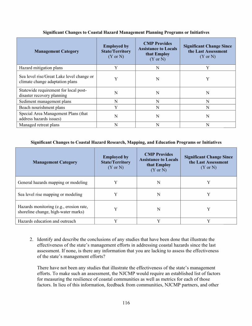
116
Significant Changes to Coastal Hazard Management Planning Programs or Initiatives
Management Category Employed by
State/Territory (Y or N)
CMP Provides Assistance to Locals
that Employ (Y or N)
Significant Change Since the Last Assessment
(Y or N)
Hazard mitigation plans Y N Y
Sea level rise/Great Lake level change or climate change adaptation plans Y N Y
Statewide requirement for local post-disaster recovery planning N N N
Sediment management plans N N N Beach nourishment plans Y N N Special Area Management Plans (that address hazards issues) N N N
Managed retreat plans N N N
Significant Changes to Coastal Hazard Research, Mapping, and Education Programs or Initiatives
Management Category Employed by
State/Territory (Y or N)
CMP Provides Assistance to Locals
that Employ (Y or N)
Significant Change Since the Last Assessment
(Y or N)
General hazards mapping or modeling Y N Y
Sea level rise mapping or modeling Y N Y
Hazards monitoring (e.g., erosion rate, shoreline change, high-water marks) Y N Y
Hazards education and outreach Y Y Y 2. Identify and describe the conclusions of any studies that have been done that illustrate the
effectiveness of the state’s management efforts in addressing coastal hazards since the last assessment. If none, is there any information that you are lacking to assess the effectiveness of the state’s management efforts?
There have not been any studies that illustrate the effectiveness of the state’s management efforts. To make such an assessment, the NJCMP would require an established list of factors for measuring the resilience of coastal communities as well as metrics for each of those factors. In lieu of this information, feedback from communities, NJCMP partners, and other

117
stakeholders regarding the actions and projects undertaken by the NJCMP could result in a similar analysis.
Identification of Priorities: 1. Considering changes in coastal hazard risk and coastal hazard management since the last
assessment and stakeholder input, identify and briefly describe the top one to three management priorities where there is the greatest opportunity for the CMP to improve its ability to more effectively address the most significant hazard risks. (Approximately 1-3 sentences per management priority.) Management Priority 1: Incorporating Sea-level Rise Projections Description: Pursuant to New Jersey Executive Orders 89 and 100 as well as NJDEP Administrative Order 2020-01, the various networked offices of the NJCMP are developing guidance for using sea level rise projections and incorporating them into plans, regulations, and policies. Using the sea-level rise projections from the 2019 STAP report, the NJCMP is developing guidance on how to select and incorporate the most appropriate sea level rise projections based on the type of activity. This guidance will be used internally within the NJDEP for the development of regulatory updates, funding decisions, and policy development. Sea level rise projections are currently under consideration for inclusion in NJDEP regulations that impact the coastal zone. Implementation of the new regulations and guidance will begin at approximately the same time as the implementation of the 2021-2025 309 strategy, providing an opportunity to monitor and evaluate their impact and effectiveness. Development of guidance for the use of sea level rise projections by local decision-makers is planned for the final year of the 2016-2020 309 strategy.
Management Priority 2: Local Resilience Planning Assistance Description: The NJCMP has and continues to provide direct support to New Jersey coastal communities. Many municipal, county, and regional communities throughout the coastal zone lack the capacity, in both resources and technical understanding, to perform the necessary analyses and to implement the appropriate steps to address coastal hazards. Coastal communities need further assistance to plan for and implement resilience and hazard mitigation strategies, including best management practices, ordinances, and Master Plan updates. Local actions should be consistent and coordinated with the actions that will be recommended in the statewide Climate Change Resilience Strategy and Coastal Resilience Plan. Management Priority 3: Risk Communication and Education Description: Another priority of the NJCMP is to improve communication and provide better education for communities regarding the risks associated with coastal hazards, now and into the future. Both the NJCMP and local governments need to better understand these risks and

118
require resources to effectively communicate the actions that can be taken to address them. Risk perception differs by population, even amongst those that experience similar kinds of events, such as flooding, and can be based on culture, economic practices, education, and the length of a particular flooding event. In recognition of these potential differences, the NJCMP applied for and was awarded a Project of Special Merit to undertake a Risk Communication Campaign for coastal New Jersey. The materials and guidance developed through this project will assist in providing education and communicating the risk of coastal hazards. However, additional measures are necessary.
2. Identify and briefly explain priority needs and information gaps the CMP has for addressing the management priorities identified above. The needs and gaps identified here should not be limited to those items that will be addressed through a Section 309 strategy but should include any items that will be part of a strategy.
Priority Needs Need? (Y or N) Brief Explanation of Need/Gap
Research Y - Improved understanding of the implications of selecting certain sea
level rise projections for use in decision-making - Better insight into fiscal impacts to municipalities
Mapping/GIS/modeling Y
- Improved watershed flood mapping with increasing precipitation and sea level rise due to climate change
- Improved wetland mapping to increase understanding of their resilience to sea level rise
- More frequent LiDAR/Bathymetric data and imagery of Coastal New Jersey
- Additional Delaware Bay shore profiles - More primary tide gauges to get better real time tidal water levels
Data and information management Y - Impacts on the economy
Training/Capacity building Y
- Training for local decision makers and internal NJCMP staff on coastal hazard impacts, adaptation/mitigation strategies, impacts on resources and assets, monitoring, and new studies
- Direct technical, planning, and educational support to local governments lacking capacity
Decision-support tools N
Communication and outreach Y - Tools that effectively communicate the impacts of coastal hazards to communities
Implementation Mechanisms Y - Ordinances, adoption of best management practices, resiliency planning policies, enabling rule changes

119
Enhancement Area Strategy Development: 1. Will the CMP develop one or more strategies for this enhancement area?
Yes __X__ No ______
2. Briefly explain why a strategy will or will not be developed for this enhancement area.
Stakeholders have identified coastal hazards as their top priority enhancement area for the 2021-2025 assessment and strategy cycle. Furthermore, Governor Phil Murphy and NJDEP Commissioner Catherine McCabe have made coastal hazards and climate resilience a high priority for the NJCMP. Multiple executive orders and an administrative order have directed the various networked offices of the NJCMP to develop strategies, plans, and regulations that address this issue, which will result in an ongoing focus on coastal hazards for the foreseeable future. New Jersey’s coastal communities are routinely impacted by coastal hazards. Sea level rise, coastal storm surges, and riverine and stormwater flooding currently present the largest risks and the greatest potential for loss of life and property as well as the loss of coastal resources. Climate change is expected to exacerbate these impacts in the coastal zone. As temperatures rise, which is expected due to current and future greenhouse gas emissions, ocean temperatures will also increase, sea levels will continue to rise, and the atmosphere will retain more moisture, resulting in higher precipitation levels and greater storm surges. As a result, more properties will be at risk from flooding. The NJCMP continues to support comprehensive planning programs that provide technical and financial assistance to coastal communities to understand their level of risk to coastal hazards on a regional level and to identify potential actions that can be taken to address the region’s risk. These planning programs result in action plans that, if implemented on the municipal and regional scale, will reduce the region’s risk to coastal hazards. Support for implementation of these action plans is currently provided in a limited number of cases. However, additional efforts and support is necessary to implement the action plans to improve the resilience of New Jersey’s coastal communities. For these reasons, the NJCMP is developing a coastal hazards strategy aimed at providing assistance to local communities to help them effectively understand and address the risks associated with coastal hazards.
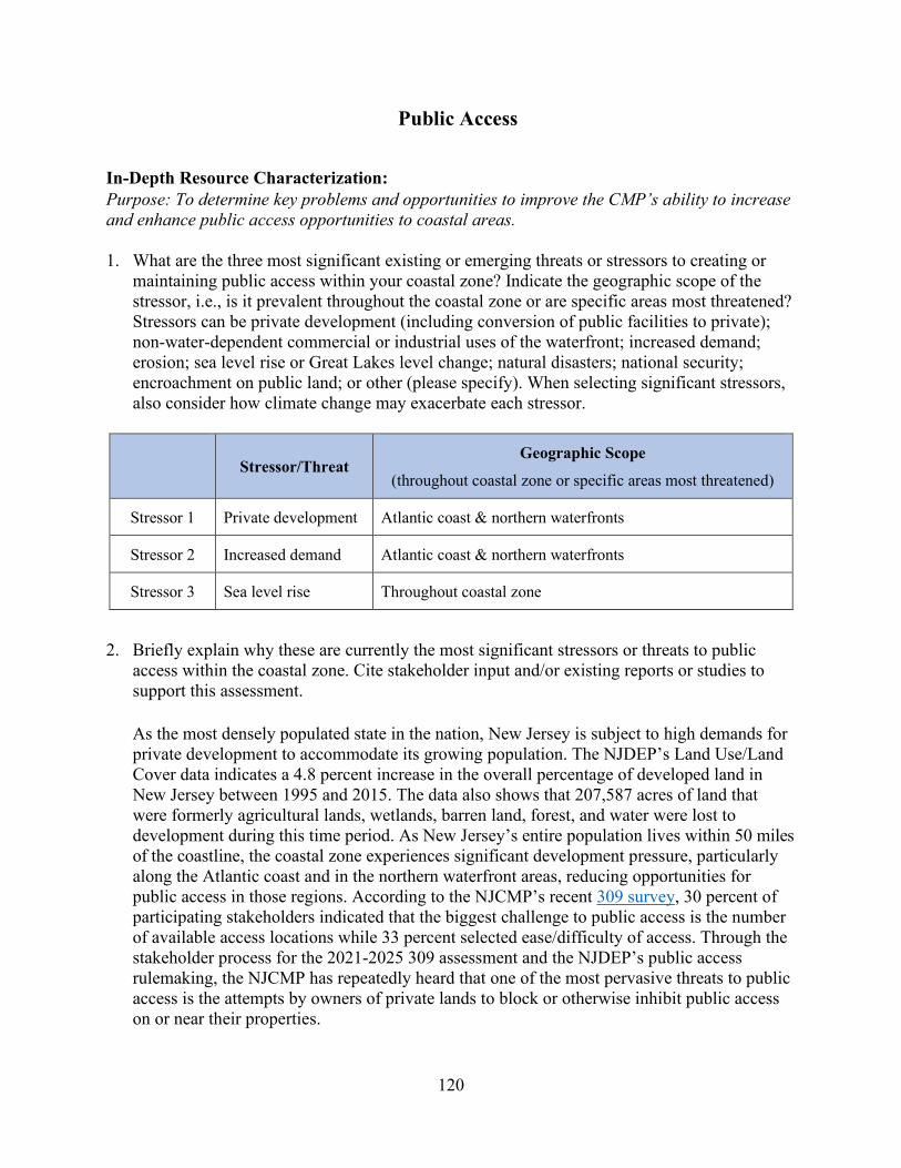
120
Public Access
In-Depth Resource Characterization: Purpose: To determine key problems and opportunities to improve the CMP’s ability to increase and enhance public access opportunities to coastal areas. 1. What are the three most significant existing or emerging threats or stressors to creating or
maintaining public access within your coastal zone? Indicate the geographic scope of the stressor, i.e., is it prevalent throughout the coastal zone or are specific areas most threatened? Stressors can be private development (including conversion of public facilities to private); non-water-dependent commercial or industrial uses of the waterfront; increased demand; erosion; sea level rise or Great Lakes level change; natural disasters; national security; encroachment on public land; or other (please specify). When selecting significant stressors, also consider how climate change may exacerbate each stressor.
Stressor/Threat
Geographic Scope
(throughout coastal zone or specific areas most threatened)
Stressor 1 Private development Atlantic coast & northern waterfronts
Stressor 2 Increased demand Atlantic coast & northern waterfronts
Stressor 3 Sea level rise Throughout coastal zone
2. Briefly explain why these are currently the most significant stressors or threats to public access within the coastal zone. Cite stakeholder input and/or existing reports or studies to support this assessment. As the most densely populated state in the nation, New Jersey is subject to high demands for private development to accommodate its growing population. The NJDEP’s Land Use/Land Cover data indicates a 4.8 percent increase in the overall percentage of developed land in New Jersey between 1995 and 2015. The data also shows that 207,587 acres of land that were formerly agricultural lands, wetlands, barren land, forest, and water were lost to development during this time period. As New Jersey’s entire population lives within 50 miles of the coastline, the coastal zone experiences significant development pressure, particularly along the Atlantic coast and in the northern waterfront areas, reducing opportunities for public access in those regions. According to the NJCMP’s recent 309 survey, 30 percent of participating stakeholders indicated that the biggest challenge to public access is the number of available access locations while 33 percent selected ease/difficulty of access. Through the stakeholder process for the 2021-2025 309 assessment and the NJDEP’s public access rulemaking, the NJCMP has repeatedly heard that one of the most pervasive threats to public access is the attempts by owners of private lands to block or otherwise inhibit public access on or near their properties.
121
In addition to its increasing population, New Jersey’s coastal region is also a major tourist destination for two of the nation’s largest metropolitan areas, New York City and Philadelphia. According to the New Jersey Division of Travel and Tourism, New Jersey had 110.8 million visitors in 2018. As population and private development increase and tourism thrives, the demand for public access increases, along with the demand for the necessary amenities, such as parking and restrooms. Of the surveyed stakeholders, 27 percent selected enhancement of amenities as one of the top challenges to public access in New Jersey. Many stakeholders have indicated at the Department’s stakeholder meetings that the lack of available parking is a major deterrent to public access, particularly along the Atlantic coast and in the northern waterfront areas. Public access throughout New Jersey’s coastal zone is vulnerable to sea level rise. Data from NOAA’s State of the Coast “Coastal Vulnerability Index” indicates that 98 percent of the New Jersey coastline is moderately to highly vulnerable. Furthermore, the Rutgers Science and Technical Advisory Panel (STAP) recently updated their report on sea-level rise and concluded that sea levels rose 17.6 inches (1.5 feet) along the New Jersey coast from 1911 to 2019, compared to a 7.6-inch (0.6 feet) total change in the global mean sea level. The report also found that New Jersey’s coastal areas face a 66 percent chance of experiencing a further 0.5 to 1.1-foot rise between 2000 and 2030 and a 0.9 to 2.1-foot rise between 2000 and 2050, threatening the availability and viability of public access locations and amenities from the northern waterfront (the area extending north from Monmouth County to the New York State boundary) to the Atlantic coast to the Delaware Bay shore. The 2019 STAP report, which is considered the best available data on sea level rise in New Jersey, can be found at https://www.nj.gov/dep/climatechange/pdf/nj-rising-seas-changing-coastal-storms-stap-report.pdf.
3. Are there emerging issues of concern, but which lack sufficient information to evaluate the level of the potential threat? If so, please list. Include additional lines if needed.
Emerging Issue Information Needed Sea level rise Sea level rise projection and mapping
In-Depth Management Characterization: Purpose: To determine the effectiveness of management efforts to address identified problems related to the public access enhancement objective. 1. For each additional public access management category below that was not already discussed
as part of the Phase I assessment, indicate if the approach is employed by the state or territory and if significant changes (positive or negative) have occurred at the state or territory level since the last assessment.

122
Significant Changes to Public Access Management
Management Category Employed by
State/Territory (Y or N)
CMP Provides Assistance to Locals
that Employ (Y or N)
Significant Changes Since
Last Assessment (Y or N)
(MPAPs) Y Y N GIS mapping/database of access sites Y Y Y
Public access technical assistance, education, and outreach (including access point and interpretive signage, etc.)
N N Y
2. For management categories with significant changes since the last assessment, briefly provide the information below. If this information is provided under another enhancement area or section of the document, please provide a reference to the other section rather than duplicate the information.
a. Describe significant changes since the last assessment; b. Specify if they were 309 or other CZM-driven changes; and c. Characterize the outcomes or likely future outcomes of the changes.
GIS mapping/database of access sites
a. In 2016, the NJCMP launched an interactive, online public access map showing over 3,900 public access locations with information regarding the available amenities at each location. This map is available at https://www.nj.gov/dep/cmp/access/. The current map is updated through June 2017. The NJCMP is in the process of updating the map based on site inspections by NJDEP staff, approved MPAPs, and information supplied by the public.
b. The 2011-2015 309 public access strategy included implementation of a Public Access Planning Program that would provide a number of tools to assist the public, including a comprehensive public access website with information about public access. The interactive public access map was created as part of the development of this website to replace a static (jpeg) New Jersey public access location map.
c. The public access map provides the public with valuable information regarding public access opportunities throughout New Jersey.
Public access technical assistance, education, and outreach (including access point and interpretive signage, etc.) Public Access Compliance Guidelines a. In response to feedback received during the stakeholder meetings held as part of the
rulemaking required by P.L.2019 c. 81 and as part of the 309 assessment process, the

123
NJCMP held a working group meeting on January 10, 2020 to address the issue of public access compliance and to solicit feedback from participants regarding potential public access compliance guidelines and/or educational materials. Ten percent of participants in the NJCMP’s stakeholder survey for the 2021-2025 309 assessment also indicated that education is one of the biggest challenges to public access. The NJCMP envisions the development of education and outreach materials as a necessary next step in ensuring reasonable and meaningful access throughout New Jersey and intends to begin the process of developing these materials in the near future.
b. These potential changes are not 309 or CZM-driven.
c. By providing New Jersey’s residents, municipalities, and public employees, such as police officers and beach badge checkers, with the necessary information and training with respect to the public’s rights to access, the laws governing beach fees, the regulations regarding public access signage, and other issues impacting public access, the NJCMP expects to improve the public’s ability to effectively access and enjoy New Jersey’s tidal waterways.
4. Identify and describe the conclusions of any studies that have been done that illustrate the effectiveness of the state’s management efforts in providing public access since the last assessment. If none, is there any information that you are lacking to assess the effectiveness of the state’s management efforts? The NY-NJ Harbor Estuary Program (HEP)’s 2016 report entitled “Connecting with Our Waterways: Public Access and its Stewardship in the New York – New Jersey Harbor Estuary” includes an assessment of public access in the estuary that was produced by compiling and mapping existing waterfront access opportunities. The study concluded that only 37 percent of the estuary’s waterfront is accessible to the public, and the number of locations where the public can physically touch the water is even more limited. For the full report, visit https://www.hudsonriver.org/wp-content/uploads/2017/10/PublicAccess-Draft_Print-Full_smallerfile.pdf. The NJCMP is not currently aware of similar studies available for the Atlantic coast or Delaware Bay shore regions. While the NJCMP provides an interactive public access map with information about public access locations and amenities, this map does not allow for the necessary statewide or region-wide assessments of public access deficits and opportunities, including areas that may be ideal for creating public access destinations with all the necessary amenities, such as sufficient parking and restrooms. This provides an opportunity for New Jersey to develop and make available more information on public access.
Identification of Priorities: 1. Considering changes in public access and public access management since the last
assessment and stakeholder input, identify and briefly describe the top one to three management priorities where there is the greatest opportunity for the CMP to improve the

124
effectiveness of its management effort to better respond to the most significant public access stressors. (Approximately 1-3 sentences per management priority.) Management Priority 1: Public Access Assessment Description: The NJCMP requires additional information regarding public access deficits and opportunities throughout New Jersey to make more informed policy decisions and to determine locations that are ideal for providing meaningful public access. Therefore, conducting a statewide public access assessment, including an assessment of public access amenities, is a high priority for the NJCMP. Management Priority 2: Creation of Meaningful Public Access Sites Description: In response to stakeholder input, which indicates that public access opportunities may be limited in certain areas due to a lack of access points and/or the necessary support amenities, such as sufficient parking, the NJCMP is prioritizing the creation of meaningful public access sites throughout New Jersey that include such support amenities and offer opportunities for recreation, socialization, and/or education. The NJCMP is also prioritizing the development of guidelines for the creation and enhancement of public access sites for persons with disabilities to ensure meaningful access for all. Management Priority 3: Education and Outreach Description: Stakeholders have mentioned the need for public access education and outreach continually throughout the stakeholder processes for the 309 assessment and the NJDEP’s public access rulemaking. To improve the public’s ability to effectively access and enjoy New Jersey’s tidal waterways, the NJCMP is prioritizing education and outreach efforts for the general public as well as for municipalities and public employees.
2. Identify and briefly explain priority needs and information gaps the CMP has to help it address the management priorities identified above. The needs and gaps identified here do not need to be limited to those items that will be addressed through a Section 309 strategy but should include any items that will be part of a strategy.

125
Priority Needs Need? (Y or N) Brief Explanation of Need/Gap
Research Y Public access opportunities and deficits, including amenities Mapping/GIS Y Public access opportunities and deficits, including amenities
Data and information management Y
A management system will be necessary to track information regarding the characteristics of public access opportunities and amenities
Training/Capacity building Y
Training for municipal officials and public employees is needed to ensure the public’s rights of access are understood and properly observed
Decision-support tools Y A map identifying public access opportunities and deficits is needed to target areas where meaningful public access can be provided
Communication and outreach Y
Public outreach is needed to ensure the public understands its public access rights as well as all applicable limitations to public access
Other – Legislative changes Y
Legislative changes are necessary to provide the NJDEP with additional statutory authority for public access, including the ability to establish a public access fund for the creation of meaningful public access sites
Enhancement Area Strategy Development: 1. Will the CMP develop one or more strategies for this enhancement area?
Yes __X__ No ______
2. Briefly explain why a strategy will or will not be developed for this enhancement area.
Stakeholders have identified public access as one of their top priority enhancement areas for the 2021-2025 assessment and strategy cycle. In addition, the New Jersey Legislature’s recent passage of P.L. 2019 c. 81 (described in the Phase I Assessment for public access) indicates the increasing concern over public access in New Jersey. In the process of amending the public access rules in response to that legislation, the NJCMP has identified information gaps with respect to public access that need to be addressed as well as a potential mechanism for funding the creation and enhancement of public access sites. Therefore, the NJCMP is developing a public access strategy aimed at assessing public access opportunities and deficits and pursuing potential legislative changes that would enable the NJCMP to provide meaningful public access throughout New Jersey.

126
Oceans and Great Lakes Resources
In-Depth Resource Characterization: Purpose: To determine key problems and opportunities to enhance the ability of state CMP to better address ocean and Great Lakes resources. 1. What are the three most significant existing or emerging stressors or threats to ocean and
Great Lakes resources within your coastal zone? Indicate the geographic scope of the stressor, i.e., is it prevalent throughout the coastal zone, or are specific areas most threatened? Stressors can be land-based development; offshore development (including pipelines, cables); offshore energy production; polluted runoff; invasive species; fishing (commercial and/or recreational); aquaculture; recreation; marine transportation; dredging; sand or mineral extraction; ocean acidification; or other (please specify). When selecting significant stressors, also consider how climate change may exacerbate each stressor.
Stressor/Threat
Geographic Scope
(throughout coastal zone or specific areas most threatened)
Stressor 1 Offshore energy development, both emerging and oil and gas Throughout coastal zone
Stressor 2 Sand extraction Throughout coastal zone (closer to shore)
Stressor 3 Increasing simultaneous demands for use (shipping, development, noise, extraction, etc.) Throughout coastal zone
2. Briefly explain why these are currently the most significant stressors or threats to ocean and Great Lakes resources within the coastal zone. Cite stakeholder input and/or existing reports or studies to support this assessment. With its dense population, high energy demands, and congested transmission capacity, New Jersey’s coastal zone is considered a prime market for siting new energy facilities. Specifically, the demand for offshore energy development has continued to increase in recent years. Since the previous Section 309 assessment, there have been multiple proposed offshore wind energy projects in federal waters off New Jersey’s coast and increased state mandates for implementing large scale offshore wind energy development. In May 2018, Governor Murphy’s Executive Order No. 28 called for the development of a statewide clean energy plan to shift away from energy production that contributes to climate change. Then on November 19, 2019, the governor signed Executive Order No. 92, which states that New Jersey’s offshore wind energy goal is now 7,500 MW by the year 2035. On January 27, 2020, New Jersey’s current Energy Master Plan (EMP) was released, which provides seven strategies to reach the administration’s goal of 100 percent clean energy by 2050.

127
New Jersey is also subject to continued interest in conventional energy development in federal waters off the state’s coast. On April 28, 2017, President Trump issued Executive Order 13795, Implementing an America-First Offshore Energy Strategy, which included directives to revise the Bureau of Ocean Energy Management’s (BOEM) five-year leasing program. This program establishes a schedule of oil and gas lease sales proposed for planning areas of the outer continental shelf (OCS), indicating the size, timing, and location of proposed leasing activities that the Secretary of the Interior determines will best meet national energy needs for the five-year period following the program’s approval. Although no further actions have been taken to revise the program, the process remains open and has the potential to lead to activities that would impact New Jersey’s coastal and ocean uses and resources. Whether renewable or conventional energy, the production, distribution, and use of energy can threaten air and water quality, human health conditions, and the state’s economy unless wisely managed. In addition, certain stakeholders have expressed concerns regarding the potential repercussions for the ocean environment resulting from offshore energy development. For these reasons, the NJCMP considers the demand for offshore energy development as a significant potential stressor to New Jersey’s ocean resources. Sand extraction is another significant stressor to ocean resources due to the increasing demand for offshore sand for post-storm disaster relief beach nourishment projects. As shown on the map provided in the Phase I Assessment for cumulative and secondary impacts, numerous beach fill and flood projects have been constructed since Superstorm Sandy in 2012, and renourishment projects continue to be undertaken along New Jersey’s coastline. Offshore sand deposits suitable for extraction are finite and are often located in important fishing grounds as the deposits attract fish and other marine species. Fisheries are already stressed by the depletion of available stock. Out of the 26 species or species groups covered by the Atlantic States Marine Fisheries Commission’s 2020 stock status overview, approximately 16 species are either depleted, overfished, or labeled as status unknown. Most of these species are currently being removed at or below the rates established in fisheries management plans. As of May 2019, one species managed by the Mid-Atlantic Fishery Management Council, which oversees fisheries in the federal waters from New York to North Carolina, is considered overfished while the status of three species are unknown. Stakeholders representing New Jersey’s fisheries have expressed significant concern to the NJCMP over the repercussions of sand extraction on fisheries resources. As explained in the Ocean Action Plan (described in the Phase I Assessment for oceans), the variety and extent of the demand for ocean space uses are increasing, placing significant strain on finite ocean resources. In addition to the commercial-scale development of offshore renewable energy and the coastal restoration and shoreline protection projects that have significantly increased demand for marine sand and gravel, commercial shipping across the Mid-Atlantic region is also increasing, which is necessitating changes to navigation routes in order to respond to the demand for larger ships to transport goods. In addition, interest is growing in the region for exploring possible use of carbon capture and storage technology to store carbon dioxide in offshore subsea geologic formations. Furthermore, New Jersey’s coastal zone suffers from significant development pressure, the impacts of which are

128
described in the assessments for public access, wetlands, and cumulative and secondary impacts. In the results from the NJCMP’s survey for this assessment and strategy process, stakeholders selected land-based development as one of the top factors negatively impacting New Jersey’s ability to plan for ocean resources over the last five years. For these reasons, the NJCMP considers the increases in multiple demands for simultaneous use of ocean space to be one of the most significant stressors to ocean resources.
3. Are there emerging issues of concern, but which lack sufficient information to evaluate the level of the potential threat? If so, please list. Include additional lines if needed.
Emerging Issue Information Needed
Climate change impacts on ocean resources Ocean acidification impacts, shifting species, changing population dynamics, storm increases (severity, number)
In-Depth Management Characterization: Purpose: To determine the effectiveness of management efforts to address identified problems related to the ocean and Great Lakes resources enhancement objective. 1. For each of the additional ocean and Great Lakes resources management categories below
that were not already discussed as part of the Phase I assessment, indicate if the approach is employed by the state or territory and if significant state- or territory-level changes (positive or negative) have occurred since the last assessment.
Significant Changes in Management of Ocean and Great Lakes Resources
Management Category Employed by
State/Territory (Y or N)
CMP Provides Assistance to Locals
that Employ (Y or N)
Significant Changes Since Last
Assessment (Y or N)
Ocean and Great Lakes research, assessment, monitoring
Y (as part of regional efforts) N Y
Ocean and Great Lakes GIS mapping/database
Y (as part of regional efforts) N Y
Ocean and Great Lakes technical assistance, education, and outreach
Y (as part of regional efforts) N Y
2. For management categories with significant changes since the last assessment, briefly provide the information below. If this information is provided under another enhancement area or section of the document, please provide a reference to the other section rather than duplicate the information.

129
a. Describe significant changes since the last assessment; b. Specify if they were 309 or other CZM-driven changes; and c. Characterize the outcomes or likely future outcomes of the changes.
Ocean and Great Lakes research, assessment, monitoring and GIS mapping/database
Mid-Atlantic Ocean Data Portal a. The data portal (http://portal.midatlanticocean.org/portal/) is an online tool kit and
resource center that consolidates available data and enables state, federal, and local governments as well as the general public to visualize and analyze ocean resources and human use information, such as fishing grounds, recreational areas, shipping lanes, habitat areas, and energy sites. The data portal serves as a platform to engage all stakeholders in the five coastal Mid-Atlantic States by providing all of the essential data and state-of-the-art mapping and visualization technology to the agencies, industries, community leaders, and stakeholders engaged in ocean planning. The data portal is continually updated as appropriate data sets that align with MARCO priorities become available. NJCMP staff serve on MARCO’s Ocean Data and Mapping Team, which is responsible for the identification of data needs across the region as well as information updates and revisions to the portal. The NJCMP has provided updated mapping for New Jersey-specific recreational fishing grounds and is working to ensure that continual updates are made to the portal’s commercial fisheries data, which is vital to New Jersey’s coastal zone. Data related to offshore wind energy development is also updated on a continuous basis.
b. These changes were 309-driven. The ocean resources strategy for 2016-2020 included improving interjurisdictional coordination and decision-making, addressing New Jersey-specific ocean resource and use interests in MARCO and mid-Atlantic RPB regional ocean planning efforts, and the collation of ocean resource and use data.
c. New Jersey’s continued participation in the development of the data portal will enable closer collaboration in the region with stakeholders and will also ensure open access to data that is vital to the comprehensive management of ocean resources and uses.
Ocean and Great Lakes technical assistance, education, and outreach Mid-Atlantic Ocean Forum a. When resources allow, MACO convenes an annual Mid-Atlantic Ocean Forum as a
venue for regional information sharing, coordination, and collaboration to enhance the region’s ability to leverage existing efforts and information across multiple state and federal government agencies, federally recognized tribes, non-governmental entities, and ocean stakeholders. The inaugural Mid-Atlantic Ocean Forum took place on March 20, 2019 at Monmouth University in West Long Branch, New Jersey with approximately 150 attendees. The meeting objectives were:
130
• To learn about planned and ongoing programs and activities of states, federal agencies, tribes, and the Mid-Atlantic Fishery Management Council that are relevant to waters off the Mid-Atlantic coast
• To review and discuss progress on previously identified opportunities for enhanced intergovernmental coordination
• To identify ways to enhance intergovernmental collaboration and data sharing to support the Ocean Data Portal and development of priority ocean data and products that will address specific ocean management challenges
• To learn about additional issues and opportunities for collaboration that would benefit from increased regional coordination
• To engage stakeholders and partners on regional ocean coordination efforts that will improve the stewardship and management of the Mid-Atlantic Ocean ecosystem and economy
• To collect input to identify opportunities for continued and additional coordination and collaboration efforts to advance regional ocean planning
The 2020 forum was scheduled for May 2020 in Manhattan, New York. However, due to the COVID-19 outbreak, forum organizers are currently working on a plan to conduct the forum remotely. The focus of the forum will be to identify and discuss existing and forthcoming challenges to the Mid-Atlantic’s ocean ecosystem and economy along with opportunities to collaborate, as consistent with each entity’s mission and priorities. MARCO and other forum organizers will focus on issues that have been identified as holding regional importance, such as:
• The collection and analysis of marine life and habitat data, including shifts in ocean species distributions
• The reduction and prevention of marine debris • The development of indicators to measure ocean health • Increased consideration of the importance of non-consumptive recreation • Ongoing dialogues on offshore renewable energy, coastal resilience, and the
beneficial reuse of sand resources • The continued development of a comprehensive ocean acidification monitoring
network and research plan • Continued operations, maintenance, and updating of the Mid-Atlantic Ocean Data
Portal
Based on stakeholder feedback received after the 2019 forum through a survey conducted in January 2020 and a MACO public webinar in February 2020, the objectives and agenda for the 2020 forum have been designed around improving direct engagement with stakeholders and looking to the future of ocean collaboration. The 2020 Ocean Forum objectives are:
131
• To generate a deeper understanding and awareness of state, federal, tribal, and Mid-Atlantic Fishery Management Council regional ocean activities and envision future needs
• To review and discuss MACO’s progress on stakeholder input and identified collaboration opportunities and to collect input on future opportunities for MACO coordination and collaboration efforts
• To identify and engage a more diverse range of ocean stakeholders interested in ocean collaboration efforts in the Mid-Atlantic
b. These changes were 309-driven. The ocean resources strategy for 2016-2020 included
improving interjurisdictional coordination and decision-making, addressing New Jersey-specific ocean resource and use interests in MARCO and mid-Atlantic RPB regional ocean planning efforts, and the collation of ocean resource and use data.
c. The annual ocean forums will provide opportunities to engage stakeholders across a myriad of issues and allow continued workgroup participation to ensure direct, focused efforts that benefit New Jersey and the region as a whole.
New Jersey-specific Stakeholder Outreach a. Through both MARCO and MACO, NJCMP staff routinely meet with stakeholders that
have an interest in coastal and ocean uses and resources. Stakeholder interests will be aligned across the various objectives of the Ocean Action Plan (described in the Phase I Assessment for oceans and Great Lakes resources) while the MARCO and MACO workgroups provide numerous opportunities for engaging in the process as well as the ability to discuss issues directly with NJCMP staff. Some of the main interests for New Jersey stakeholders to date are fisheries, offshore wind energy development, public access, and ensuring a heathy ocean environment.
b. These changes were 309-driven. The ocean resources strategy for 2016-2020 included addressing New Jersey-specific ocean resource and use interests in MARCO and mid-Atlantic RPB regional ocean planning efforts.
c. The NJCMP’s coordination efforts with New Jersey stakeholders, particularly the state’s fisheries, may highlight areas where changes are needed to New Jersey’s enforceable policies, such as possible updates to the submerged cable rule to address submerged electric transmission lines that are part of planned offshore wind turbine arrays.
3. Identify and describe the conclusions of any studies that have been done that illustrate the
effectiveness of the state’s or territory’s management efforts in planning for the use of ocean and Great Lakes resources since the last assessment. If none, is there any information that you are lacking to assess the effectiveness of the state’s or territory’s management efforts?
132
While there are no specific studies on the effectiveness of these management efforts, the collaborative nature of the process and the engagement with stakeholders provides clear, actionable feedback.
Identification of Priorities: 1. Considering changes in threats to ocean and Great Lakes resources and management since
the last assessment and stakeholder input, identify and briefly describe the top one to three management priorities where there is the greatest opportunity for the CMP to improve its ability to effectively plan for the use of ocean and Great Lakes resources. (Approximately 1-3 sentences per management priority.) Management Priority 1: Addressing New Jersey Ocean Resource Interests in Regional Ocean Planning Efforts Description: To leverage the resources available through both MARCO and MACO, the NJCMP will continue to participate in these efforts and seek to ensure that New Jersey ocean resource objectives are addressed. The NJCMP will gather information and data that improves ocean planning, resource protection, and sustainable uses. The NJCMP will work with partners to fill gaps in data on ocean resources and potential impacts of ocean uses. For example, NJCMP staff works closely with the data portal team to ensure data, such as fisheries data, is continuously updated and synthesized into useful products. Management Priority 2: Coordination with Academic and Environmental Non-governmental Organizations Description: The responsibility for planning and grant management has shifted amongst various programs within the NJCMP over recent years, which has affected the consistency of the program’s reach and influence and diminished its ability to establish and maintain meaningful ties with important academic institutions and non-governmental organizations that are actively engaged in coastal and ocean science and policy considerations. The NJCMP is currently prioritizing the reestablishment of those crucial connections. Management Priority 3: Ensuring Resilient, Robust Working Waterfronts Description: Water-dependent uses of New Jersey’s coastal waters are critical to the state’s economy and residents. To ensure these working waterfronts remain resilient in the face of climate change, development pressures, and shifting uses, the NJCMP is exploring regulatory changes that support working waterfronts, including changes that consider climate change impacts and offshore wind development needs.
2. Identify and briefly explain priority needs and information gaps the CMP has to help it address the management priorities identified above. The needs and gaps identified here do not need to be limited to those items that will be addressed through a Section 309 strategy but should include any items that will be part of a strategy.
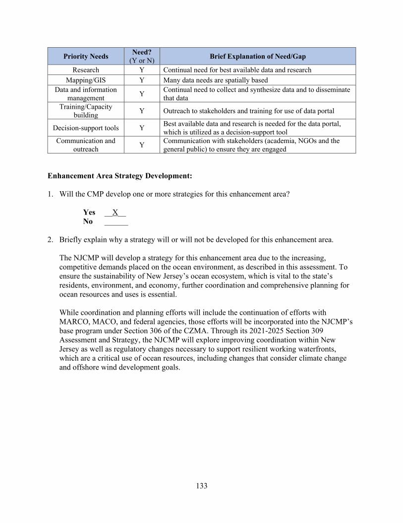
133
Priority Needs Need? (Y or N) Brief Explanation of Need/Gap
Research Y Continual need for best available data and research Mapping/GIS Y Many data needs are spatially based
Data and information management Y Continual need to collect and synthesize data and to disseminate
that data Training/Capacity
building Y Outreach to stakeholders and training for use of data portal
Decision-support tools Y Best available data and research is needed for the data portal, which is utilized as a decision-support tool
Communication and outreach Y Communication with stakeholders (academia, NGOs and the
general public) to ensure they are engaged Enhancement Area Strategy Development: 1. Will the CMP develop one or more strategies for this enhancement area?
Yes __X__ No ______
2. Briefly explain why a strategy will or will not be developed for this enhancement area.
The NJCMP will develop a strategy for this enhancement area due to the increasing, competitive demands placed on the ocean environment, as described in this assessment. To ensure the sustainability of New Jersey’s ocean ecosystem, which is vital to the state’s residents, environment, and economy, further coordination and comprehensive planning for ocean resources and uses is essential. While coordination and planning efforts will include the continuation of efforts with MARCO, MACO, and federal agencies, those efforts will be incorporated into the NJCMP’s base program under Section 306 of the CZMA. Through its 2021-2025 Section 309 Assessment and Strategy, the NJCMP will explore improving coordination within New Jersey as well as regulatory changes necessary to support resilient working waterfronts, which are a critical use of ocean resources, including changes that consider climate change and offshore wind development goals.
134
IV. Strategies The strategy is a comprehensive, multi-year statement of goals to address high priority needs, as identified in the assessments, for improving the CMP. The strategy also lays out methods for achieving those goals, which are designed to lead toward one or more program changes (as defined by 15 CFR 923.123a). The NJCMP determined through the Phase I and Phase II Assessments to develop strategies for all four of the enhancement areas that received a high-priority ranking – wetlands, coastal hazards, public access, and ocean and Great Lakes resources. The NJCMP used the template provided by NOAA to develop these strategies. The template includes estimated costs, a schedule, and a general work plan listing necessary steps for achieving the strategy goals. Detailed information on annual tasks, budgets, and work products will be determined through the annual award negotiation process. The strategies for the four high-priority enhancement areas may be found on the following pages.
135
Wetlands Strategy Adapting to Sea Level Rise
I. Issue Area(s)
The proposed strategy or implementation activities will support the following high-priority enhancement areas (check all that apply):
Aquaculture Cumulative and Secondary Impacts Energy and Government Facility Siting Wetlands Coastal Hazards Marine Debris Ocean/Great Lakes Resources Public Access Special Area Management Planning
II. Strategy Description
A. The proposed strategy will lead to, or implement, the following types of program changes (check all that apply):
A change to coastal zone boundaries; New or revised authorities, including statutes, regulations, enforceable policies,
administrative decisions, executive orders, and memoranda of agreement/understanding; New or revised local coastal programs and implementing ordinances; New or revised coastal land acquisition, management, and restoration programs; New or revised special area management plans (SAMP) or plans for areas of
particular concern (APC) including enforceable policies and other necessary implementation mechanisms or criteria and procedures for designating and managing APCs; and,
New or revised guidelines, procedures, and policy documents which are formally adopted by a state or territory and provide specific interpretations of enforceable CZM program policies to applicants, local government, and other agencies that will result in meaningful improvements in coastal resource management.
B. Strategy Goal: The NJCMP seeks to ensure that coastal wetlands can effectively adapt to sea level rise through vertical accretion and/or inland migration. Regulatory changes will provide additional support and monitoring for ecologically based hazard mitigation strategies designed to help retain the necessary sediment to maintain tidal marsh elevations, such as living shorelines and beneficial reuse of dredged material. The NJCMP also proposes to develop acquisition programs and/or regulatory changes that will support the inland

136
migration of coastal wetlands in situations where vertical accretion cannot keep pace with sea level rise.
C. Describe the proposed strategy and how the strategy will lead to and/or implement the program changes selected above. If the strategy will only involve implementation activities, briefly describe the program change that has already been adopted, and how the proposed activities will further that program change. (Note that implementation strategies are not to exceed two years.)
To effectively adapt to sea level rise, coastal wetlands must be able to accrete vertically at a rate fast enough to prevent marsh inundation. For marshes that cannot accrete at a suitable pace, the ability to migrate inland provides a secondary mechanism for marsh survival. Since the previous Section 309 Assessment and Strategy, the NJCMP has provided assistance and regulatory guidance on nature-based solutions that can assist with the vertical accretion of coastal wetlands. Through its experiences with these projects, the program has identified several potential amendments to the CZM Rules that would further facilitate ecologically based hazard mitigation strategies, including amendments to further prioritize these solutions over bulkheads and hard armoring and allow for a more streamlined permitting process for these beneficial projects. To further inform the regulatory changes, the NJCMP and other NJDEP programs will conduct necessary research on sediment retention, map how sediment moves through New Jersey’s coastal zone, and work with the New Jersey Tidal Wetlands Monitoring Network (described in the Phase I Assessment for wetlands) to identify areas of accretion and tidal wetland losses. The findings of the Seven Mile Island Innovation Lab (described in the Phase II Assessment for wetlands) and other nature-based solution projects will also be incorporated into the NJCMP’s policies and regulations. In addition, as part of this strategy, the NJCMP will continue to encourage and evaluate the use of living shorelines and wetlands restoration projects through monitoring, community advocacy, workgroups, trainings, and presentations. Implementation of this strategy will be completed in coordination with the CERAP (described in the Phase I Assessment for wetlands). The NJCMP will also pursue regulatory changes and potential acquisition programs that will facilitate the inland migration of coastal wetlands in response to sea level rise. The strategy includes identifying potential wetland migration pathways based on elevation and development barriers, assessing existing mapping of pathways and barriers, and developing new mapping if necessary. Where barriers exist, an assessment will be conducted to identify the barriers and to determine if the wetland could benefit from an ecologically based hazard mitigation strategy. Following the mapping and assessments, the NJCMP will determine the potential to establish an acquisition program for properties that would provide space for wetland migration and adopt policies and/or regulatory changes to facilitate such a program, including but not limited to changes to the mitigation banking program, as well as policy and/or regulatory changes that will address barriers to migration.

137
III. Needs and Gaps Addressed Identify what priority needs and gaps the strategy addresses, and explain why the proposed program change or implementation activities are the most appropriate means to address the priority needs and gaps. This discussion should reference the key findings of the assessment and explain how the strategy addresses those findings. As described in the Phase I and Phase II Assessments, approximately 98 percent of New Jersey’s coastline is moderately to very highly vulnerable to sea level rise. Furthermore, the Phase II Assessment explains that one foot of sea level rise may cause more than 19,200 acres of salt marsh to convert to open water by 2050, and trends in long-term monitoring of tidal wetlands across the state suggest that at current rates of sea level rise, tidal marshes are not able to accrete vertically at a fast enough rate to prevent the marshes from drowning. For marshes that cannot accrete quickly enough, inland migration could prevent marsh loss. However, along many portions of New Jersey’s coast, development located upland of the marsh edge forms a physical barrier to inland migration. At one foot of sea level rise, more than 4,500 acres of New Jersey’s salt marshes could be impeded from migration. To combat these potential losses resulting from sea level rise, New Jersey needs more information regarding sediment retention, how sediment moves through New Jersey’s coastal zone, areas of accretion and tidal wetland losses, potential paths for marsh migration, and all other pertinent information necessary to determine a marsh’s ability to adapt to sea level rise. This strategy addresses these informational needs. The strategy also addresses the need for policy and/or regulatory changes and programs that will facilitate and prioritize marsh accretion and marsh migration by addressing development barriers and promoting ecologically based hazard mitigation strategies so that New Jersey’s coastal wetlands remain resilient as sea levels continue to rise.
IV. Benefits to Coastal Management
Discuss the anticipated effect of the strategy, including the scope and value of the strategy, in advancing improvements in the CMP and coastal management, in general. Sea level rise increases the risk of wetland shoreline loss. New Jersey’s coastal wetlands provide essential habitat for numerous species of flora and fauna and protect people and property during storm events by absorbing floodwaters. Based on the 2010 U.S. Census, over 7.9 million people in New Jersey live in coastal areas that are at a high or very high risk from coastal erosion. As a result of this strategy, the NJDEP and NJCMP will have the necessary information and regulatory ability to ensure coastal wetlands remain resilient to sea level rise, which will help protect New Jersey’s vulnerable coastal zone.
V. Likelihood of Success Discuss the likelihood of attaining the strategy goal and program change (if not part of the strategy goal) during the five-year assessment cycle or at a later date. Address the nature and degree of support for pursuing the strategy and the proposed program change, as well as the
138
specific actions the state or territory will undertake to maintain or build future support for achieving and implementing the program change, including education and outreach activities. The NJDEP recently established the New Jersey Protecting Against Climate Change (NJ PACT) initiative in response to Governor Phil Murphy’s call for a targeted regulatory reform that will modernize environmental laws. NJ PACT will usher in systematic change, modernizing air quality and environmental land use regulations, that will enable governments, businesses, and residents to effectively respond to current climate threats and reduce future climate damages. As the proposed strategy will ensure that coastal wetlands can adapt to sea level rise, the strategy supports the goals of the NJ PACT initiative. As the strategy has also received significant support from stakeholders, the NJCMP believes the policy and/or regulatory changes will be achieved within the five-year assessment cycle. To ensure implementation of this program change, the NJDEP will amend all applicable rules. Any mapping and data resulting from this strategy will be made available to the public through the NJCMP’s website and will also be utilized as part of education and outreach efforts.
VI. Strategy Work Plan Using the template below, provide a general work plan that includes the major steps that will lead toward or achieve a program change or implement a previously achieved program change. For example, even if the final adoption of the program change is outside of the CMP’s control, what steps will be included in the work plan so the CMP ensures the program change is considered, reviewed, and hopefully adopted by the outside entity? Who are the other stakeholders or elected officials that need to be engaged, and how and when during the strategy development process? What is the decision-making or voting process that is involved in the adoption of the program change, and how will the CMP interact with this process to ensure that the proposed program change is considered? If the state intends to fund implementation activities for the proposed program change, describe those in the plan as well. The plan should identify a schedule for completing the strategy and include major projected milestones (key products, deliverables, activities, and decisions) and budget estimates. If an activity will span two or more years, it can be combined into one entry (i.e., Years 2-3 rather than Year 2 and then Year 3). While the annual milestones are a useful guide to ensure the strategy remains on track, OCM recognizes that they may change somewhat over the course of the five-year strategy due to unforeseen circumstances. The same holds true for the annual budget estimates. Further detailing and adjustment of annual activities, milestones, and budgets will be determined through the annual cooperative agreement negotiation process.
Strategy Goal: To ensure that coastal wetlands can effectively adapt to sea level rise through vertical accretion and/or inland migration Total Years: 5 Total Budget: $642,500.00
Year(s): 1-3 Description of activities: Research and Assessment – Ecologically Based Hazard Mitigation Strategies
139
The NJCMP will conduct research regarding tidal wetland conditions, including sediment retention, how sediment moves through New Jersey’s coastal zone, and areas of accretion and tidal wetland losses. Following the research, mapping will be developed to show accreting wetland areas and coastal wetland losses. A white paper will provide an analysis of sediment retention and how sediment moves through New Jersey’s coastal zone. The NJCMP will also assess the feasibility of ecologically based hazard mitigation strategies for use in vulnerable coastal areas with its internal and external living shorelines workgroups by providing technical and compliance assistance for nature-based solutions, conducting community outreach efforts, and evaluating the implementation and monitoring of ecologically based hazard mitigation strategy pilots conducted by the NJCMP and its partners. The NJCMP will present these findings in a second white paper that will determine the need for new and improved ecological techniques and policies that support the restoration of New Jersey’s coastal shorelines and marshes. Major Milestone(s):
• Development of mapping showing accreting coastal wetland areas and coastal wetland losses
• Completion of a white paper analyzing sediment retention and how sediment moves through New Jersey’s coastal zone
• Completion of a white paper assessing ecologically based hazard mitigation strategies to determine the need for new and improved ecological techniques and policies that support the restoration of New Jersey’s coastal shorelines and marshes
Budget: $198,750 Year(s): 4-5 Description of activities: Policy and Regulatory Amendments – Ecologically Based Hazard Mitigation Strategies The NJCMP will evaluate current policies and regulations based on the results of the research and assessment activities conducted in years 1 through 3 and recommend changes necessary to support the vertical accretion of coastal wetlands. The evaluation will include best mechanisms and processes to provide incentives for the implementation, monitoring, and maintenance of ecologically based hazard mitigation strategies. Major Milestone(s):
• Develop regulatory amendments to the CZM rules that facilitate sediment retention and vertical accretion in coastal wetlands through ecologically based hazard mitigation strategies. These regulatory amendments will be based on the results of the NJCMP’s research and assessment activities, including integration of and coordination with CERAP.
• Develop any additional policies necessary to support ecologically based hazard mitigation strategies
Budget: $139,750.00
140
Year(s): 1-3 Description of activities: Research and Assessment – Marsh Migration The NJCMP will conduct research for potential pathways for inland marsh migration, assess existing mapping of pathways and barriers to migration, and develop new mapping if necessary. Following the research, assessment, and mapping, a white paper will summarize the overall migration potential of New Jersey’s coastal wetlands. The paper will also analyze those wetlands that are currently unable to migrate, including any barriers to their migration and their potential to benefit from ecologically based hazard mitigation strategies. Major Milestone(s):
• Assessment/development of mapping for potential pathways for marsh migration and barriers to migration
• Completion of a white paper summarizing the migration potential of New Jersey’s coastal wetlands and analyzing those wetlands that are currently unable to migrate, including the barriers to their migration and their potential to benefit from ecologically based hazard mitigation strategies
Budget: $164,250 Year(s): 4-5 Description of activities: Policy and Regulatory Amendments – Marsh Migration The NJCMP will evaluate current policies, regulations, and programs based on the results of the research and assessment activities conducted in years 1 through 3. The NJCMP will also assess its ability to establish an acquisition program for lands that would provide space for wetland migration and will review the mitigation banking program for the potential to include wetland migration areas, including a determination of how to assess the value of these areas. The NJCMP will then adopt policy and/or regulatory changes necessary to facilitate inland marsh migration, including changes necessary for land acquisition and to address existing and future barriers to migration. Major Milestone(s):
• Develop regulatory amendments to facilitate inland migration of coastal wetlands, including changes necessary for land acquisition and to address existing and future barriers to migration. These regulatory amendments will be based on the results of the NJCMP’s research and assessment activities.
• Develop any additional policies necessary to support the inland migration of coastal wetlands
Budget: $139,750.00
VII. Fiscal and Technical Needs A. Fiscal Needs: If 309 funding is not sufficient to carry out the proposed strategy, identify
additional funding needs. Provide a brief description of what efforts the CMP has made, if any, to secure additional state funds from the legislature and/or from other sources to support this strategy.

141
Section 309 funding will support research, assessment, and evaluation for these wetland strategies but is unlikely to fully fund them. Therefore, additional grants, incentives, and other financial resources will be sought to implement this strategy.
B. Technical Needs: If the state does not possess the technical knowledge, skills, or equipment
to carry out all or part of the proposed strategy, identify these needs. Provide a brief description of what efforts the CMP has made, if any, to obtain the trained personnel or equipment needed (for example, through agreements with other state agencies). The NJCMP anticipates requiring additional research and technical support from other programs and offices within NJDEP, its partner academic institutions, non-governmental organizations, and other state and federal agencies to conduct the necessary research and assessments for ecologically based hazard mitigation strategies and marsh migration pathways.
VIII. Projects of Special Merit (Optional) If desired, briefly state what projects of special merit the CMP may wish to pursue to augment this strategy. (Any activities that are necessary to achieve the program change or that the state intends to support with baseline funding should be included in the strategy above.) The information in this section will not be used to evaluate or rank projects of special merit and is simply meant to give CMPs the option to provide additional information if they choose. Project descriptions should be kept very brief (e.g., undertake benthic mapping to provide additional data for ocean management planning). Do not provide detailed project descriptions that would be needed for the funding competition. At this time, the NJCMP does not propose to submit a project of special merit to supplement this strategy. If the situation or conditions change, this opportunity will be explored.

142
5-Year Budget Summary Wetlands Strategy
At the end of the strategy section, please include the following budget table summarizing your anticipated Section 309 expenses by strategy for each year.
Strategy Title Year 1 Funding
Year 2 Funding
Year 3 Funding
Year 4 Funding
Year 5 Funding
Total Funding
Research and Assessment – Ecologically Based Hazard Mitigation Strategies
$89,250 $54,750 $54,750 $198,750
Policy and Regulatory Amendments – Ecologically Based Hazard Mitigation Strategies
$54,750 $85,000 $139,750
Research and Assessment – Marsh Migration $54,750 $54,750 $54,750 $164,250
Policy and Regulatory Amendments – Marsh Migration
$54,750 $85,000 $139,750
Total Funding $144,000 $109,500 $109,500 $109,500 $170,000 $642,500

143
Coastal Hazards Strategy Providing Assistance to Coastal Communities Through a Regional Resilience
Coordinator Program
I. Issue Area(s) The proposed strategy or implementation activities will support the following high-priority enhancement areas (check all that apply):
Aquaculture Cumulative and Secondary Impacts Energy and Government Facility Siting Wetlands Coastal Hazards Marine Debris Ocean/Great Lakes Resources Public Access Special Area Management Planning
II. Strategy Description
A. The proposed strategy will lead to, or implement, the following types of program changes (check all that apply):
A change to coastal zone boundaries; New or revised authorities, including statutes, regulations, enforceable policies,
administrative decisions, executive orders, and memoranda of agreement/understanding; New or revised local coastal programs and implementing ordinances; New or revised coastal land acquisition, management, and restoration programs; New or revised special area management plans (SAMP) or plans for areas of
particular concern (APC) including enforceable policies and other necessary implementation mechanisms or criteria and procedures for designating and managing APCs; and,
New or revised guidelines, procedures, and policy documents which are formally adopted by a state or territory and provide specific interpretations of enforceable CZM program policies to applicants, local government, and other agencies that will result in meaningful improvements in coastal resource management.
B. Strategy Goal: The NJCMP proposes to develop and pilot a Regional Resilience Coordinator program that will assist coastal communities to increase community resilience to coastal hazards in a coordinated manner that is consistent with the policies, regulations, and guidance of the NJCMP.
144
C. Describe the proposed strategy and how the strategy will lead to and/or implement the program changes selected above. If the strategy will only involve implementation activities, briefly describe the program change that has already been adopted, and how the proposed activities will further that program change. (Note that implementation strategies are not to exceed two years.)
As noted in the Phase II Assessment for coastal hazards, feedback received by NJCMP staff working with coastal communities indicates that local governments throughout the coastal zone lack the capacity, in both resources and technical understanding, to perform the necessary analyses and implement the appropriate steps to address coastal hazards. This strategy seeks to supplement the limited capacity of New Jersey’s coastal communities by providing them with direct assistance, guidance, and technical support to enable them to take those steps towards greater resiliency. The Regional Resilience Coordinator program will engage three to five employees (depending on whether the employees are full or part-time) to act as Regional Resilience Coordinators. The coordinators will be tasked with assisting local governments incorporate resilience measures into local ordinances, master plans, and other planning documents and providing other guidance and support as appropriate. The coordinators will provide assistance to all coastal communities within a designated region and will be based in “field offices” throughout New Jersey’s coastal zone in order to limit travel so that each coordinator can be more accessible to the communities in their region. The regions will be determined based on the number of coordinators engaged, the level of interest from coastal communities, and New Jersey’s land use/shoreline types (e.g., urban northeast, Raritan Bayshore, Atlantic coastal mainland, barrier islands/back bays, Delaware Bayshore/river, etc.).
III. Needs and Gaps Addressed
Identify what priority needs and gaps the strategy addresses, and explain why the proposed program change or implementation activities are the most appropriate means to address the priority needs and gaps. This discussion should reference the key findings of the assessment and explain how the strategy addresses those findings. As described in the Phase I and II Assessments, New Jersey is experiencing increased threats from sea level rise, coastal storms, and riverine and stormwater flooding. The NJCMP has taken steps to increase the resilience of local governments to these hazards through its 2016-2020 309 strategy as well as multiple stand-alone projects. The NJCMP and its partners have created multiple tools to inform community action, provided assistance to communities to perform vulnerability analyses, and worked with a number of communities to identify specific resilience actions. However, stakeholders still consistently comment on the challenges associated with navigating the many available tools and processes, the need for state guidance with respect to how local governments can and should proceed, and the lack of resources available to implement resilience activities. Many communities still lack the capacity to undertake the necessary first steps, much less implement specific recommendations.
The Regional Resilience Coordinator program will identify three to five employees or representatives (depending on whether full-time or part-time) to work directly with coastal
145
communities to help them navigate existing tools and guidance, identify appropriate resilience actions, and implement those actions. The resilience actions associated with this process are expected to be “planning only” actions, such as research, mapping, outreach/education, ordinances, master plan amendments, and conceptual design.
IV. Benefits to Coastal Management
Discuss the anticipated effect of the strategy, including the scope and value of the strategy, in advancing improvements in the CMP and coastal management, in general. As a result of this strategy, New Jersey’s coastal communities will receive guidance and assistance to develop and implement planning actions, and the NJDEP and NJCMP will collect valuable information that will ultimately result in better-informed and prepared residents as well as changes to land use patterns that will decrease New Jersey’s vulnerability to coastal hazards.
V. Likelihood of Success
Discuss the likelihood of attaining the strategy goal and program change (if not part of the strategy goal) during the five-year assessment cycle or at a later date. Address the nature and degree of support for pursuing the strategy and the proposed program change, as well as the specific actions the state or territory will undertake to maintain or build future support for achieving and implementing the program change, including education and outreach activities. Even before Superstorm Sandy impacted New Jersey’s coast in 2012, the NJCMP began to successfully develop and lead multiple projects, programs, and activities to assist coastal communities address their vulnerabilities to coastal hazards. To date, these activities have included the Coastal Vulnerability Index, Getting to Resilience, Coastal Vulnerability Assessment, Resilient Coastal Communities Initiative, Sustainable+Resilient Coastal Communities, NJ FRAMES, and Resilient NJ. The NJCMP has also developed tools, research, and guidance and funded the creation of multiple nature-based resilience projects throughout the coastal zone. Over 90 communities have been involved with these efforts. Yet a significant number of New Jersey’s coastal communities have not participated in NJCMP resilience planning activities. As noted previously, the NJCMP has determined that this is due primarily to a lack of capacity and expertise. The NJCMP has and continues to develop tools and guidance to support coastal communities. The coordinator program will provide further assistance to coastal communities in accordance with NJCMP tools, guidance, policies, and regulations, and the program will maintain consistency with the Coastal Resilience Plan that is currently under development.
VI. Strategy Work Plan Using the template below, provide a general work plan that includes the major steps that will lead toward or achieve a program change or implement a previously achieved program change. For example, even if the final adoption of the program change is outside of the CMP’s control, what steps will be included in the work plan so the CMP ensures the program change is

146
considered, reviewed, and hopefully adopted by the outside entity? Who are the other stakeholders or elected officials that need to be engaged, and how and when during the strategy development process? What is the decision-making or voting process that is involved in the adoption of the program change, and how will the CMP interact with this process to ensure that the proposed program change is considered? If the state intends to fund implementation activities for the proposed program change, describe those in the plan as well. The plan should identify a schedule for completing the strategy and include major projected milestones (key products, deliverables, activities, and decisions) and budget estimates. If an activity will span two or more years, it can be combined into one entry (i.e., Years 2-3 rather than Year 2 and then Year 3). While the annual milestones are a useful guide to ensure the strategy remains on track, OCM recognizes that they may change somewhat over the course of the five-year strategy due to unforeseen circumstances. The same holds true for the annual budget estimates. Further detailing and adjustment of annual activities, milestones, and budgets will be determined through the annual cooperative agreement negotiation process.
Strategy Goal: To develop and pilot a Regional Resilience Coordinator Program for possible institutionalization in the NJCMP’s annual 306 program that provides assistance to coastal communities in order to build capacity to address unmet community needs to increase community resilience to coastal hazards in a coordinated manner consistent with the policies, regulations, and guidance of the NJCMP Total Years: 4 Total Budget: $547,500.00
Year(s): 1 Description of activities: Program Development A program plan will be developed to provide the details of the Regional Resilience Coordinator Program. Questions to be addressed include:
• What are the specific roles and responsibilities of the coordinators? • What are the areas of greatest need and therefore, greatest benefits? • How many coordinators are needed to provide sufficient assistance to coastal
communities? • What locations throughout the coastal zone may be used as “bases of operations”
for the coordinators (e.g., NJDEP satellite offices, NJCMP coastal partners offices, etc.)?
• Should the coordinators be hired as temporary employees or contractors or should the NJCMP enter into agreements with coastal partners?
• What specific expertise and experience should be required of the coordinators? • How should coastal partners be engaged? • Is there sufficient guidance for the coordinators to utilize? • What are the appropriate metrics to determine if the program is successful?
Major Milestone(s): • Regional Resilience Coordinator program plan

147
o Job description and education/experience requirements for coordinators o Possible template Memorandum of Understanding/Agreement with coastal
partners to act as and/or host coordinators • Development of guidance, procedure, and policy documents to guide activities of
coordinators and local governments o Evaluation of existing guidance including recommendations for further
development o Possible contract/sub-recipient agreement to develop further guidance
(dependent on previous milestone) Budget: $75,000.00 Year(s): 2-4 Description of activities: Implementation/Pilot of Regional Resilience Coordinator Program
• During this period, the NJCMP will recruit and engage three to five people (depending on whether full or part-time) to act as coordinators consistent with the program plan developed in Year 1.
• The NJCMP will finalize the package of guidance, procedure, and policy documents for use by the Regional Resilience Coordinators. Documents will be developed by the NJCMP based on the outcomes of Year 1. This complete guidance package will continue to be refined and supplemented over time to reflect the current policies.
• Regional Resilience Coordinators will work with coastal communities within their regions to assist in incorporating coastal hazards resilience measures into local ordinances, master plans, and other planning documents and provide guidance and support, as appropriate, based on the established roles and responsibilities.
Major Milestone(s): • Hiring of three to five coordinators • Package of guidance, procedure, and policy documents • Annual reports summarizing coordinator activities, successes, and challenges • Compilation of local documents developed through program to be provided as
examples for other New Jersey coastal communities Budget: $155,00.00 per year (assumes three full-time coordinators) or $465,000.00 total for three years. Budget may differ should the NJCMP engage coordinators through a different mechanism.
Year(s): 2-4 Description of activities: Evaluation and Recommendations
• To ensure that the Regional Resilience Coordinator program is effective, the NJCMP will evaluate the program on an annual basis pursuant to the metrics

148
developed in Year 1. The NJCMP will modify coordinator roles and responsibilities and documents as necessary and appropriate.
• At the end of Year 4, the NJCMP will perform an evaluation of the Regional Resilience Coordinator program and develop a proposal with options and preferred alternatives for whether and how the Regional Resilience Coordinator program should be institutionalized under the NJCMP’s annual Section 306 program.
Major Milestone(s): • Annual evaluation of program • Recommendation for application as part of the annual CZM grant program under
Section 306 of the CZMA Budget: $7,500 (total NJCMP staff time across three years)
VII. Fiscal and Technical Needs A. Fiscal Needs: If 309 funding is not sufficient to carry out the proposed strategy, identify
additional funding needs. Provide a brief description of what efforts the CMP has made, if any, to secure additional state funds from the legislature and/or from other sources to support this strategy. Section 309 funding will be sufficient to fund three to five coordinator positions through three years of implementation/piloting of the proposed strategy. The NJCMP will pursue federal and other funding opportunities that may arise in order to fund additional pilot regions.
B. Technical Needs: If the state does not possess the technical knowledge, skills, or equipment
to carry out all or part of the proposed strategy, identify these needs. Provide a brief description of what efforts the CMP has made, if any, to obtain the trained personnel or equipment needed (for example, through agreements with other state agencies). The NJCMP possesses the technical knowledge, skills, and equipment to carry out the proposed strategy, working with its partner academic institutions, non-governmental organizations, and other state and federal agencies to supplement the technical skill set required to complete the strategy.
VIII. Projects of Special Merit (Optional) If desired, briefly state what projects of special merit the CMP may wish to pursue to augment this strategy. (Any activities that are necessary to achieve the program change or that the state intends to support with baseline funding should be included in the strategy above.) The information in this section will not be used to evaluate or rank projects of special merit and is simply meant to give CMPs the option to provide additional information if they choose. Project descriptions should be kept very brief (e.g., undertake benthic mapping to provide additional data for ocean management planning). Do not provide detailed project descriptions that would be needed for the funding competition.

149
At this time, the NJCMP does not propose to submit a project of special merit to supplement this strategy. If the situation or conditions change, this opportunity will be explored.
5-Year Budget Summary Coastal Hazards Strategy
At the end of the strategy section, please include the following budget table summarizing your anticipated Section 309 expenses by strategy for each year.
Strategy Title Year 1 Funding
Year 2 Funding
Year 3 Funding
Year 4 Funding
Year 5 Funding
Total Funding
Program Development $75,000 $75,000
Implementation/Pilot Program $155,000 $155,000 $155,00 $465,000
Evaluation and Recommendations $2,000 $2,000 $3,500 $7,500
Total Funding $75,000 $157,000 $157,000 $158,500 $547,500

150
Public Access Strategy Facilitating Meaningful Public Access for All
I. Issue Area(s)
The proposed strategy or implementation activities will support the following high-priority enhancement areas (check all that apply):
Aquaculture Cumulative and Secondary Impacts Energy and Government Facility Siting Wetlands Coastal Hazards Marine Debris Ocean/Great Lakes Resources Public Access Special Area Management Planning
II. Strategy Description
A. The proposed strategy will lead to, or implement, the following types of program changes (check all that apply):
A change to coastal zone boundaries; New or revised authorities, including statutes, regulations, enforceable policies,
administrative decisions, executive orders, and memoranda of agreement/understanding; New or revised local coastal programs and implementing ordinances; New or revised coastal land acquisition, management, and restoration programs; New or revised special area management plans (SAMP) or plans for areas of
particular concern (APC) including enforceable policies and other necessary implementation mechanisms or criteria and procedures for designating and managing APCs; and,
New or revised guidelines, procedures, and policy documents which are formally adopted by a state or territory and provide specific interpretations of enforceable CZM program policies to applicants, local government, and other agencies that will result in meaningful improvements in coastal resource management.
B. Strategy Goal: The NJCMP seeks to facilitate the creation of meaningful public access for all by pursuing legislative changes necessary to provide the NJDEP with additional statutory authority, including the ability to establish a public access fund for the creation and enhancement of public access sites throughout New Jersey. The NJCMP also proposes to conduct a statewide assessment of public access deficits and opportunities to assist the NJDEP in determining where and how to utilize the funds and to guide other public access developments while ensuring the protection of ecological resources throughout New Jersey’s coastal zone. The assessment will also provide information regarding the current

151
status of public access in New Jersey to help inform future public access policy decisions. Finally, the NJCMP aims to research New Jersey’s existing public access opportunities for people with disabilities and to develop a white paper that assesses the NJCMP’s current policies and programs for providing meaningful public access to this community.
C. Describe the proposed strategy and how the strategy will lead to and/or implement the program changes selected above. If the strategy will only involve implementation activities, briefly describe the program change that has already been adopted, and how the proposed activities will further that program change. (Note that implementation strategies are not to exceed two years.)
With the passage of P.L. 2015 c. 260 on January 19, 2016, the Waterfront Development Law (N.J.S.A. 12:5-3) and CAFRA (N.J.S.A. 13:19-10) were amended to provide the NJDEP with the statutory authority to require public access to the waterfront and adjacent shorelines as a condition of an approval for waterfront development. In 2019, under P.L. 2019 c. 81, the legislature extended the NJDEP’s authority to require public access as a condition of approvals issued pursuant to the Flood Hazard Area Control Act, N.J.S.A. 58:16A-50 et seq. However, neither legislation provided the NJDEP with the authority to establish and manage a public access fund that would allow permittees to meet their public access requirements via a monetary contribution. Therefore, the NJCMP proposes a strategy for developing statutory changes, including providing proposed language, to the New Jersey Legislature that will provide additional statutory authority, including the authority to establish a public access fund to be managed by the NJDEP. To facilitate passage of the necessary legislation, the NJCMP will also develop criteria for collecting monetary contributions for the fund as well as a framework for managing and dispersing the funds. To help implement the fund, the NJCMP also proposes to conduct a statewide assessment of public access deficits and opportunities. This assessment will help identify locations and amenities that should be targeted for creation or enhancement to address gaps in public access, capitalize on existing public access potential, and ensure the protection of environmental resources. The public access funds collected by the NJDEP will be allocated according to this assessment. The NJDEP will also use the assessment to recommend public access projects to organizations and individuals who need or wish to provide public access without making a monetary contribution in municipalities that do not have an NJDEP-approved municipal public access plan. The assessment will also provide a detailed view of all existing public access in New Jersey, which may lead to changes in policies, regulations, and/or approaches to public access. Finally, the NJCMP proposes to develop a white paper that assesses the NJCMP’s current policies and programs for providing public access to people with disabilities. The objective of this white paper is to propose recommendations for policy and/or regulatory program changes to ensure that adequate public access opportunities are available to disabled persons, including public access with the that meets federal Americans with Disabilities Act (ADA) standards.
152
III. Needs and Gaps Addressed Identify what priority needs and gaps the strategy addresses, and explain why the proposed program change or implementation activities are the most appropriate means to address the priority needs and gaps. This discussion should reference the key findings of the assessment and explain how the strategy addresses those findings. As indicated in the Phase I and II Assessments, New Jersey is experiencing increases in both development and demand for public access, resulting in insufficient or unsatisfactory access for the public throughout most of the coastal zone. Stakeholders have indicated that public access opportunities in New Jersey are limited not only by a deficiency in access locations in some areas of the state but also by the lack of support amenities necessary for a meaningful experience, such as sufficient parking, restrooms, picnic options, recreational structures or facilities for activities like fishing or boating, and accessways suitable for disabled persons. Due to financial and/or development restraints, providing these amenities is rarely a feasible option for applicants who need to satisfy a public access requirement. For this reason, the NJCMP believes a public access fund will assist the NJDEP to fill existing gaps in public access and to leverage opportunities to create meaningful access experiences. Statutory authority is a prerequisite for establishing this fund. To accurately determine where public access gaps and possibilities are located and how best to address them, the NJCMP requires information regarding existing public access deficits and opportunities across the entire coastal zone, which only a thorough public access assessment will provide. The assessment will also help the NJCMP to identify areas where public access is not appropriate due to the potential environmental impacts, such as areas with critical wildlife habitat and other areas of ecological significance. Finally, as indicated in the Phase I Assessment, New Jersey has not examined its public access with respect to persons with disabilities, including determining if there is available access that is compliant with the Americans with Disabilities Act (ADA). The proposed white paper analyzing New Jersey’s programs and policies for providing public access for disabled persons is a crucial first step in this examination.
IV. Benefits to Coastal Management
Discuss the anticipated effect of the strategy, including the scope and value of the strategy, in advancing improvements in the CMP and coastal management, in general. As a result of this strategy, the NJDEP and NJCMP will have the necessary information, financial ability, and flexibility to establish a variety of meaningful public access destinations across the coastal zone, taking into account the differing needs and demands of each region and population as well as any potential environmental impacts. The strategy will also provide a broader understanding of New Jersey’s existing public access, leading to more informed policy decisions and ensuring more equitable access is provided throughout the state while also ensuring the protection of New Jersey’s ecological resources. Finally, the strategy will help

153
improve accessibility for persons with disabilities, representing New Jersey’s first public access initiative that will specifically target a socially vulnerable community. This strategy may provide a model for examining other vulnerable communities, improving the state’s ability to address the public access needs of all of its citizens.
V. Likelihood of Success
Discuss the likelihood of attaining the strategy goal and program change (if not part of the strategy goal) during the five-year assessment cycle or at a later date. Address the nature and degree of support for pursuing the strategy and the proposed program change, as well as the specific actions the state or territory will undertake to maintain or build future support for achieving and implementing the program change, including education and outreach activities. The public access fund has received a positive response from the majority of stakeholders, including the environmental, business and industry, and development communities as well as other state agencies. Therefore, the NJCMP believes it is likely the statutory changes proposed in this strategy will be achieved within the five-year assessment cycle. To ensure implementation of this program change, the NJDEP will subsequently amend the public access rules at N.J.A.C. 7:7-16.9 to incorporate the fund. Stakeholders also expressed support for the public access assessment, which the NJCMP is confidant can be completed during the assessment cycle. Once completed, this assessment will be made available to the public through the NJCMP’s website and will also be utilized as part of the education and outreach efforts the NJCMP plans to develop for public access outside of this 309 strategy. The proposal to examine public access for people with disabilities received overwhelming support from stakeholders. The NJCMP is also receiving support and assistance from the Edward J. Bloustein School of Planning and Public Policy and the New Jersey Department of Human Service’s Division of Disability Services. Once completed, the proposed white paper will be used to inform changes to policies and/or regulations.
VI. Strategy Work Plan Using the template below, provide a general work plan that includes the major steps that will lead toward or achieve a program change or implement a previously achieved program change. For example, even if the final adoption of the program change is outside of the CMP’s control, what steps will be included in the work plan so the CMP ensures the program change is considered, reviewed, and hopefully adopted by the outside entity? Who are the other stakeholders or elected officials that need to be engaged, and how and when during the strategy development process? What is the decision-making or voting process that is involved in the adoption of the program change, and how will the CMP interact with this process to ensure that the proposed program change is considered? If the state intends to fund implementation activities for the proposed program change, describe those in the plan as well. The plan should identify a schedule for completing the strategy and include major projected milestones (key products, deliverables, activities, and decisions) and budget estimates. If an activity will span two or more years, it can be combined into one entry (i.e., Years 2-3 rather than Year 2 and then Year 3).

154
While the annual milestones are a useful guide to ensure the strategy remains on track, OCM recognizes that they may change somewhat over the course of the five-year strategy due to unforeseen circumstances. The same holds true for the annual budget estimates. Further detailing and adjustment of annual activities, milestones, and budgets will be determined through the annual cooperative agreement negotiation process. Strategy Goal: To facilitate the creation of meaningful and equitable public access throughout New Jersey, including adequate support amenities and opportunities for recreation, socialization, and/or education for all Total Years: 5 Total Budget: $549,500.00
Year(s): 1-2 Description of activities: Statutory Changes The NJCMP will continue to engage with the New Jersey Legislature, the NJDEP Commissioner, the Attorney General’s Office, and stakeholders to develop proposed statutory changes providing NJDEP with additional public access authority, including the authority to establish and manage a public access fund. Major Milestone(s): Development of proposed statutory language for establishing a public access fund as well as criteria for collecting monetary contributions and a framework for managing and dispersing funds Budget: $40,000 Year(s): 1-5 Description of activities: Public Access Assessment and Evaluation The NJCMP will identify a methodology and procedure for assessing and mapping existing public access, including the identification of public access deficits and opportunities as well as potential ecological impacts. Following identification of the appropriate methods and procedures, the assessment will be conducted in all municipalities within the coastal zone, and a new public access map will be created that identifies potential locations for new or enhanced public access. The NJCMP will then analyze the results of the assessment and produce a white paper providing an evaluation of the identified public access deficits and opportunities as well as the sites where public access is not desirable due to potential environmental concerns. Major Milestone(s):
• Identification of public access assessment and mapping methodologies and procedures
• Completion of a statewide assessment of existing public access deficits and opportunities and a new public access map of potential locations for new or enhanced public access
• Completion of a white paper analyzing and evaluating identified deficits and opportunities as well as areas of potential ecological impact
Budget: $381,500.00
155
Year(s): 4-5 Description of activities: Recommendations for Disabled Communities The NJCMP will engage with the community of disabled persons to determine their public access needs and challenges. The NJCMP will also utilize existing partnerships and stakeholders to identify public access locations that are accessible to disabled persons and create an inventory of the amenities provided at each location for inclusion in the statewide public access assessment described above. Finally, the NJCMP will examine its current policies and programs for providing public access to disabled persons, identify recommendations for policy and/or regulatory program changes that will improve and enhance public access opportunities for people with disabilities, and finalize a white paper including the assessment of existing public access opportunities for disabled persons and their public access needs and challenges as well as recommendations for program changes to address those needs and challenges. Major Milestone(s):
• Creation of an inventory of public access locations and associated amenities that are accessible to disabled persons
• Completion of a white paper identifying the challenges and needs faced by the community of disabled persons and providing recommendations for policy and/or regulatory program changes to address those needs and challenges
Budget: $128,000
VII. Fiscal and Technical Needs A. Fiscal Needs: If 309 funding is not sufficient to carry out the proposed strategy, identify
additional funding needs. Provide a brief description of what efforts the CMP has made, if any, to secure additional state funds from the legislature and/or from other sources to support this strategy. Section 309 funding should be sufficient to pursue the necessary statutory changes to establish the public access fund and to complete the statewide public access assessment and the white paper analyzing public access for people with disabilities. Additional grants, incentives, and other financial resources may be sought to conduct additional research for the development of guidelines for constructing public accessways and amenities suitable for disabled persons. Additional funding resources may also be sought to research public access for other vulnerable communities.
B. Technical Needs: If the state does not possess the technical knowledge, skills, or equipment
to carry out all or part of the proposed strategy, identify these needs. Provide a brief description of what efforts the CMP has made, if any, to obtain the trained personnel or equipment needed (for example, through agreements with other state agencies). The NJCMP anticipates requiring additional research and technical support from its partner academic institutions, non-governmental organizations, and other state and federal agencies to conduct its statewide public access assessment.
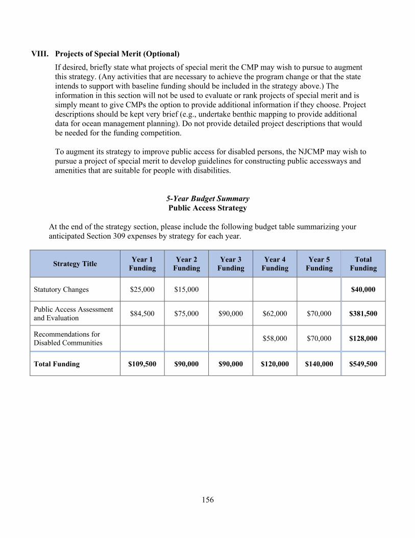
156
VIII. Projects of Special Merit (Optional) If desired, briefly state what projects of special merit the CMP may wish to pursue to augment this strategy. (Any activities that are necessary to achieve the program change or that the state intends to support with baseline funding should be included in the strategy above.) The information in this section will not be used to evaluate or rank projects of special merit and is simply meant to give CMPs the option to provide additional information if they choose. Project descriptions should be kept very brief (e.g., undertake benthic mapping to provide additional data for ocean management planning). Do not provide detailed project descriptions that would be needed for the funding competition. To augment its strategy to improve public access for disabled persons, the NJCMP may wish to pursue a project of special merit to develop guidelines for constructing public accessways and amenities that are suitable for people with disabilities.
5-Year Budget Summary Public Access Strategy
At the end of the strategy section, please include the following budget table summarizing your anticipated Section 309 expenses by strategy for each year.
Strategy Title Year 1 Funding
Year 2 Funding
Year 3 Funding
Year 4 Funding
Year 5 Funding
Total Funding
Statutory Changes $25,000 $15,000 $40,000
Public Access Assessment and Evaluation $84,500 $75,000 $90,000 $62,000 $70,000 $381,500
Recommendations for Disabled Communities $58,000 $70,000 $128,000
Total Funding $109,500 $90,000 $90,000 $120,000 $140,000 $549,500

157
Oceans and Great Lakes Resources Strategy Informing Policies to Improve Ocean Use and Resource Management
I. Issue Area(s)
The proposed strategy or implementation activities will support the following high-priority enhancement areas (check all that apply):
Aquaculture Cumulative and Secondary Impacts Energy and Government Facility Siting Wetlands Coastal Hazards Marine Debris Ocean/Great Lakes Resources Public Access Special Area Management Planning
II. Strategy Description
A. The proposed strategy will lead to, or implement, the following types of program changes (check all that apply):
A change to coastal zone boundaries; New or revised authorities, including statutes, regulations, enforceable policies,
administrative decisions, executive orders, and memoranda of agreement/understanding; New or revised local coastal programs and implementing ordinances; New or revised coastal land acquisition, management, and restoration programs; New or revised special area management plans (SAMP) or plans for areas of
particular concern (APC) including enforceable policies and other necessary implementation mechanisms or criteria and procedures for designating and managing APCs; and,
New or revised guidelines, procedures, and policy documents which are formally adopted by a state or territory and provide specific interpretations of enforceable CZM program policies to applicants, local government, and other agencies that will result in meaningful improvements in coastal resource management.
B. Strategy Goal: The NJCMP seeks to develop a strategy that will inform existing and future policies to improve ocean use and resource management in New Jersey. Specifically, the NJCMP will establish a Science Policy Advisory Network (SPAN) that will rebuild strong ties between the NJCMP, academia, and relevant non-governmental organizations in order to address emerging issues and new information and data for existing ocean uses and resources and integrate coordination mechanisms that will ensure science and policy continually inform one another. The NJCMP will also identify any regulatory changes necessary to support

158
resilient working waterfronts, including changes related to climate change and offshore wind energy needs and goals.
C. Describe the proposed strategy and how the strategy will lead to and/or implement the program changes selected above. If the strategy will only involve implementation activities, briefly describe the program change that has already been adopted, and how the proposed activities will further that program change. (Note that implementation strategies are not to exceed two years.)
The responsibility for planning and grant management has shifted amongst various programs within the NJCMP over recent years, which has affected the consistency of the program’s reach and influence and diminished its ability to establish and maintain meaningful ties with important academic institutions and non-governmental organizations that are actively engaged in coastal and ocean science and policy considerations. The Science Policy Advisory Network (SPAN) will help ensure that policy decisions are informed by the most recent science and vice versa by serving as an advisory body that supports the NJCMP with the most current coastal and ocean science and policy. Under this strategy, the NJCMP will plan to establish a nimble network of various academic and non-governmental organizations that clearly identifies areas of interest and expertise. Currently, a multitude of issues in the nearshore and offshore environment must be addressed; however, while the network will be established under the ocean resources enhancement area, the intent is to establish a robust network that stretches beyond ocean resources into broader coastal management issues. Ultimately this network will promote synergies with various coastal and ocean related efforts, recognizing that all of the involved entities have limited resources. The SPAN will provide ongoing support to the NJCMP as an advisory body on coastal and ocean science and policy and will also serve as a communications and data-sharing network. As part of establishing this network, the NJCMP will host biannual symposiums, the State of Coastal Management, which would cover a breadth of science and policy issue areas related to coastal management. The strategy will also include research and policy changes to assist with the conservation of existing and historic working waterfronts and to provide opportunities for emerging water-dependent uses that require water access. These important uses are critical to New Jersey’s economy and residents. This strategy includes examining existing ports and waterfront types across the coastal zone, as well as in other coastal areas throughout the nation, to better define working waterfronts and to identify the issues that need to be addressed to support these facilities. Recognizing the various working waterfront types, such as bulk container ports, fishery related ports, coastal dependent science and education centers, and marinas, and understanding their water dependencies, historic and cultural significance, scale, and related resources and capacities will inform the development of regulatory changes that can help the NJCMP address their needs. Such regulatory changes will include climate change considerations to ensure resiliency as well as considerations necessary to meet the needs and goals for offshore wind development.
159
III. Needs and Gaps Addressed Identify what priority needs and gaps the strategy addresses, and explain why the proposed program change or implementation activities are the most appropriate means to address the priority needs and gaps. This discussion should reference the key findings of the assessment and explain how the strategy addresses those findings. As indicated in the Phase 1 and II Assessments, there is a need to coordinate and plan for ocean resources and uses in a comprehensive manner to ensure the sustainability of New Jersey’s ocean ecosystem, which is vital to the state’s residents, environment, and economy. While regional coordination and planning efforts continue through MARCO and MACO, the increasing demand to use the ocean off New Jersey’s coast for both alternative and conventional energy coupled with the need for better management of the state’s existing ocean uses, as described in the Phase II Assessment, necessitates stronger coordination within New Jersey, specifically with the state’s academic institutions and relevant non-governmental organizations, to target research and data collection on new issues and to use existing research and data to address known concerns. Through the proposed network (SPAN), the NJCMP will be able to ensure that policy decisions are based on sound, local science while current policy needs and requirements may prompt relevant scientific research in New Jersey. These local efforts will also inform regional planning efforts and ensure New Jersey-specific needs continue to be met on a regional level. Also, as explained in the Phase II Assessment, New Jersey’s working waterfronts have long been a critical economic, cultural, and historic component of the coastal zone. These areas have also become necessary to realizing New Jersey’s renewable energy goals but are highly vulnerable to climate change. Therefore, these areas need the support of the NJCMP. However, the NJCMP currently lacks sufficient understanding of the complexities and needs of working waterfronts to develop policies and/or suggest regulatory changes that will adequately address the issues facing these critical areas. This strategy incorporates research and analysis to address that crucial lack in understanding, which will allow the NJCMP to provide the necessary support through policy and regulatory reform.
IV. Benefits to Coastal Management
Discuss the anticipated effect of the strategy, including the scope and value of the strategy, in advancing improvements in the CMP and coastal management, in general. Understanding New Jersey’s valuable ocean resources is essential to making smart, ecologically sustainable policy decisions that will have a direct benefit to the residents within and beyond the boundaries of New Jersey’s coastal zone. For example, as part of the release of New Jersey’s Energy Master Plan, Governor Phil Murphy has established targeted regulatory reform teams that will modernize environmental laws through the Protecting Against Climate Threats (PACT) initiative. NJ PACT will usher in systematic change, modernizing air quality and environmental land use regulations, that will enable governments, businesses, and residents to effectively respond to current climate threats and reduce future climate damages. Renewable energy is a significant component of this effort. The proposed Science Policy Advisory Network will provide the NJCMP with greater understanding and knowledge and

160
will improve coordination and data-sharing with and among academic institutions and relevant non-governmental organizations to more accurately inform such efforts and policy decisions. A deeper understanding of New Jersey’s working waterfronts will identify those policy and regulatory changes necessary to ensure that water-dependent activities continue to thrive within New Jersey’s coastal communities. In addition, the NJCMP will be able to identify those activities that are not water dependent and help them to establish outside of the waterfront areas in a resilient and ecologically beneficial manner.
V. Likelihood of Success Discuss the likelihood of attaining the strategy goal and program change (if not part of the strategy goal) during the five-year assessment cycle or at a later date. Address the nature and degree of support for pursuing the strategy and the proposed program change, as well as the specific actions the state or territory will undertake to maintain or build future support for achieving and implementing the program change, including education and outreach activities. New Jersey’s stakeholders have indicated support for both the proposed Science Policy Advisory Network and the research and policy changes necessary to support working waterfronts. Therefore, the NJCMP believes that both of these strategies will be achieved within the five-year assessment cycle. To ensure implementation of any regulatory changes identified as necessary to incorporate existing science and/or to address issues facing working waterfronts, the NJDEP will subsequently amend all applicable rules as necessary.
VI. Strategy Work Plan Using the template below, provide a general work plan that includes the major steps that will lead toward or achieve a program change or implement a previously achieved program change. For example, even if the final adoption of the program change is outside of the CMP’s control, what steps will be included in the work plan so the CMP ensures the program change is considered, reviewed, and hopefully adopted by the outside entity? Who are the other stakeholders or elected officials that need to be engaged, and how and when during the strategy development process? What is the decision-making or voting process that is involved in the adoption of the program change, and how will the CMP interact with this process to ensure that the proposed program change is considered? If the state intends to fund implementation activities for the proposed program change, describe those in the plan as well. The plan should identify a schedule for completing the strategy and include major projected milestones (key products, deliverables, activities, and decisions) and budget estimates. If an activity will span two or more years, it can be combined into one entry (i.e., Years 2-3 rather than Year 2 and then Year 3). While the annual milestones are a useful guide to ensure the strategy remains on track, OCM recognizes that they may change somewhat over the course of the five-year strategy due to unforeseen circumstances. The same holds true for the annual budget estimates. Further detailing and adjustment of annual activities, milestones, and budgets will be determined through the annual cooperative agreement negotiation process.

161
Strategy Goal: To improve ocean use and resource management in New Jersey through data collection and analysis, expanded local coordination, and data-sharing efforts on ocean resources and uses that ensure informed policy and regulatory changes to address current and emerging issues Total Years: 5 Total Budget: $450,500.00
Year(s): 1-2 Description of activities: Network Development The NJCMP will establish a framework for the Science Policy Advisory Network, most likely utilizing a contractor to properly scope the development of the network and to assist in researching similar existing efforts and appropriate coordination mechanisms while conducting outreach to relevant groups. The framework will include the process through which the SPAN will be formally integrated as a communications and data-sharing network and an advisory body to the NJCMP, the roles and responsibilities of the network, and the means through which the SPAN will provide ongoing support to the NJCMP, including how information and data needs will be prioritized, shared, and addressed, such as appropriate means of communication and/or establishment of routine coordination meetings, data portals, research requests, etc. The NJCMP will also organize and host a workshop to introduce the network and finalize the framework. Major Milestone(s):
• Develop a draft framework establishing the network with interested entities as signatories to this framework
• Organize and host a workshop to introduce the network and to finalize the framework, officially formalizing the SPAN as an advisory body to the NJCMP
Budget: $73,000
Year(s): 3 Description of activities: Network Launch The NJCMP will launch the Science Policy Advisory Network by organizing and hosting the inaugural biannual State of Coastal Management Symposium, which will seek to increase coordination and collaboration amongst the entities of the network. Major Milestone(s): Organize and host the inaugural biannual State of Coastal Management Symposium Budget: $36,500.00
Year(s): 1-3 Description of activities: Working Waterfronts Research and Assessment The NJCMP will conduct research to identify and assess the needs of working waterfronts. First, the NJCMP will seek to define working waterfronts in New Jersey’s coastal zone. The program will then research issues and concerns at the various types of working waterfronts that have been included in that definition by identifying critical infrastructure

162
(both onsite and offsite) necessary for operations, existing conflicts and challenges, and extreme weather and climate change concerns as well as the current resiliency. The NJCMP will also attempt to identify future challenges that may require specific assistance unrelated to the usual onsite conflicts (e.g., shifting species concerns for fisheries, ocean acidification and management challenges, etc.). Major Milestone(s):
• Development of a white paper defining working waterfronts and identifying type-specific critical infrastructure as well as issues and challenges
• Establishment of a Working Waterfronts workgroup to further examine the findings in the white paper and to provide guidance on necessary next steps. The workgroup will be comprised of NJDEP programs, other state agencies, and stakeholders from the affected communities.
Budget: $163,000.00
Year(s): 4-5 Description of activities: Identify Regulatory Changes for Working Waterfronts The NJCMP will identify potential policy and regulatory changes necessary to fully address the issues facing working waterfronts in New Jersey’s coastal zone, including changes that support the NJDEP’s efforts regarding climate change and offshore wind development, where applicable. This effort will likely be closely aligned with the efforts undertaken through the statewide Climate Change and Resilience Strategy and Coastal Resilience Plan under Executive Order No. 89 (described in the Phase I Assessment for the coastal hazards enhancement area). Major Milestone(s): Completion of an examination of enforceable polices where regulatory changes can support working waterfronts, including changes relating to climate change and offshore wind development needs and goals Budget: $178,000.00
VII. Fiscal and Technical Needs A. Fiscal Needs: If 309 funding is not sufficient to carry out the proposed strategy, identify
additional funding needs. Provide a brief description of what efforts the CMP has made, if any, to secure additional state funds from the legislature and/or from other sources to support this strategy.
Section 309 funding will support research, assessment, piloting, and evaluation of these ocean strategies but is unlikely to fully fund them, particularly the proposed Science Policy Advisory Network. Therefore, additional grants, incentives, and other financial resources will be sought to implement this strategy.
B. Technical Needs: If the state does not possess the technical knowledge, skills, or equipment
to carry out all or part of the proposed strategy, identify these needs. Provide a brief description of what efforts the CMP has made, if any, to obtain the trained personnel or equipment needed (for example, through agreements with other state agencies).

163
The NJCMP anticipates requiring additional research and technical support from its partner academic institutions, non-governmental organizations, and other state and federal agencies to establish the Science Policy Advisory Network and to assess New Jersey’s working waterfronts.
VIII. Projects of Special Merit (Optional) If desired, briefly state what projects of special merit the CMP may wish to pursue to augment this strategy. (Any activities that are necessary to achieve the program change or that the state intends to support with baseline funding should be included in the strategy above.) The information in this section will not be used to evaluate or rank projects of special merit and is simply meant to give CMPs the option to provide additional information if they choose. Project descriptions should be kept very brief (e.g., undertake benthic mapping to provide additional data for ocean management planning). Do not provide detailed project descriptions that would be needed for the funding competition. At this time, the NJCMP does not propose to submit a project of special merit to supplement this strategy. If the situation or conditions change, this opportunity will be explored.
5-Year Budget Summary
Oceans and Great Lakes Resources Strategy
At the end of the strategy section, please include the following budget table summarizing your anticipated Section 309 expenses by strategy for each year.
Strategy Title Year 1 Funding
Year 2 Funding
Year 3 Funding
Year 4 Funding
Year 5 Funding
Total Funding
Network Development $36,500 $36,500 $73,000
Network Launch $36,500 $36,500
Working Waterfronts Research and Assessment $73,000 $45,000 $45,000 $163,000
Identify Regulatory Changes for Working Waterfronts
$50,000 $128,000 $178,000
Total Funding $109,500 $81,500 $81,500 $50,000 $128,000 $450,500
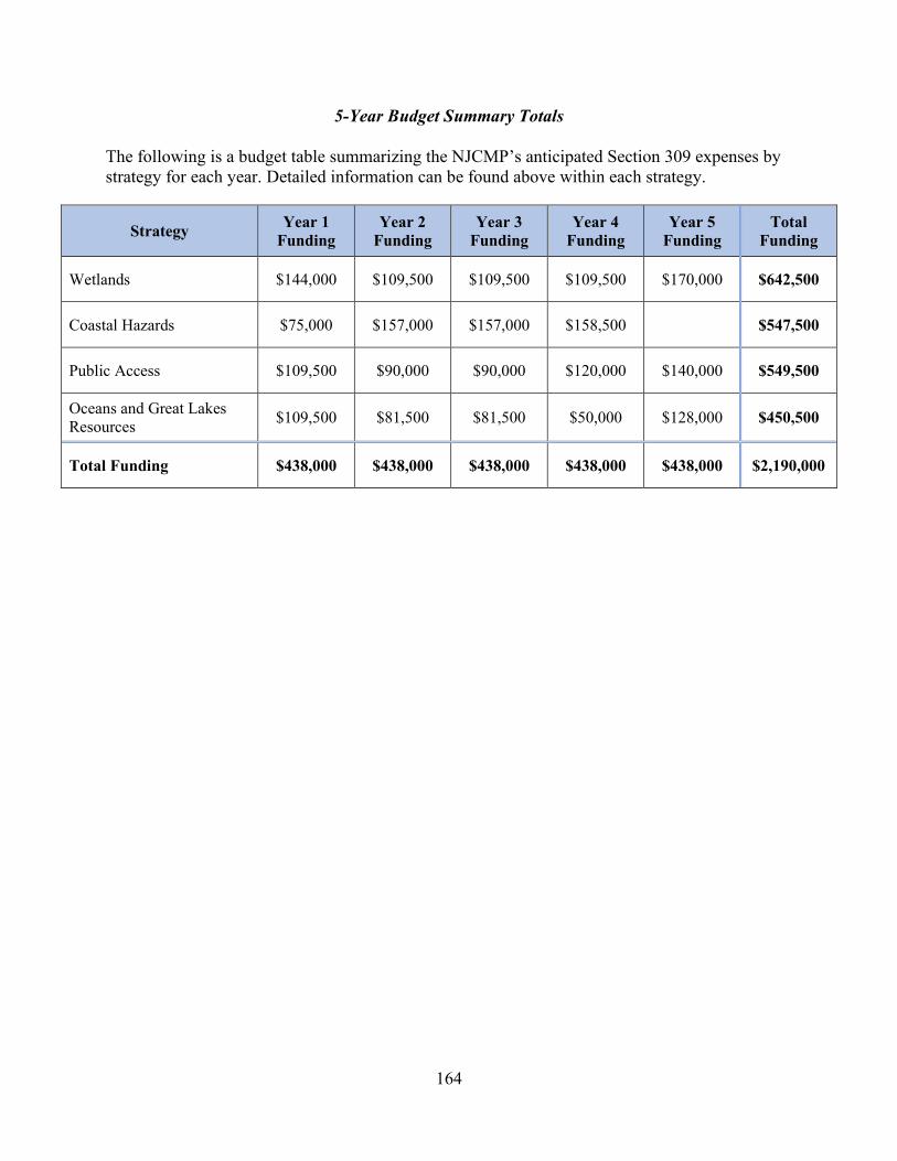
164
5-Year Budget Summary Totals
The following is a budget table summarizing the NJCMP’s anticipated Section 309 expenses by strategy for each year. Detailed information can be found above within each strategy.
Strategy Year 1 Funding
Year 2 Funding
Year 3 Funding
Year 4 Funding
Year 5 Funding
Total Funding
Wetlands $144,000 $109,500 $109,500 $109,500 $170,000 $642,500
Coastal Hazards $75,000 $157,000 $157,000 $158,500 $547,500
Public Access $109,500 $90,000 $90,000 $120,000 $140,000 $549,500
Oceans and Great Lakes Resources $109,500 $81,500 $81,500 $50,000 $128,000 $450,500
Total Funding $438,000 $438,000 $438,000 $438,000 $438,000 $2,190,000
165
V. Summary of Stakeholder and Public Comment The CZMA and NJCMP place a strong emphasis on public participation and encourage the participation, coordination, and cooperation with and among appropriate local, state, federal, and regional groups to help carry out the goals of the CZMA. In keeping with the intent of the CZMA, the Section 309 Assessment and Strategy is a public document. The NJCMP provided multiple opportunities for key stakeholders and the public to be engaged in and help inform the development of the assessments and strategies, including review of this document. A summary of the stakeholder engagement and public comment follows.
Stakeholder Engagement At the beginning of the assessment and strategy development process, the NJCMP identified key internal and external stakeholders. The stakeholders provided feedback regarding priority enhancement areas for the state’s coastal zone, the critical problems related to those priority areas, and the greatest opportunities for the NJCMP to strengthen and enhance its program to more effectively address those problems. The NJCMP incorporated this feedback into the assessments and strategies. As a result, the priorities and needs identified in this document reflect more than NJCMP staff opinions. An internal stakeholder meeting was held on October 21, 2019. Feedback included cross program priorities, data needs, and potential enhancement area strategies. Engagement from external stakeholders was solicited through a series of stakeholder meetings, including an ice breaker meeting, as well as a stakeholder survey, all of which are described in more detail below. The stakeholders who were invited to participate are identified in Appendix A. External stakeholder feedback was used to support assessment and priority conclusions as well as strategy decisions. Ice Breaker Meeting The NJCMP began the stakeholder engagement process with an ice breaker meeting on October 11, 2019 at the Jacques Cousteau National Estuarine Research Reserve in Tuckerton, New Jersey. This meeting included approximately 45 select stakeholders with collective expertise across all nine enhancement areas. The goal of the meeting was to introduce the NJCMP and solicit general feedback regarding the appropriate direction for this Section 309 enhancement cycle. To effectively and efficiently engage a larger group of external stakeholders, the participants at the ice breaker meeting also helped develop questions to be included in an online survey to gather input from a larger group of participants across all nine enhancement areas. Survey of External Stakeholders On October 23, 2019, the NJCMP sent notice of the online survey to the stakeholders identified in Appendix A and all municipal and county officials in the coastal zone and posted the survey on the NJCMP’s web page. The NJCMP received completed surveys from 39 stakeholders, representing approximately 24 percent of the stakeholders invited to participate. The external

166
stakeholders identified in Appendix A include those who were invited to participate in the survey. Participating stakeholders represented local governments, industry, federal agencies, environmental and non-profit organizations, and other groups, including the NJDEP. The percentage of the respondents with expertise in each of the enhancement areas were as follows:
The stakeholders were asked to rank the enhancement areas in order of priority from one to nine, with one being the most important and nine being the least important. The five enhancement areas with the highest overall rankings included coastal hazards, wetlands, cumulative and secondary impacts, ocean resources, and public access, followed closely by marine debris. The complete results are shown on the chart on the next page. The NJCMP found that the external stakeholder survey responses closely aligned with the assessments and internal stakeholder process results and program expectations.
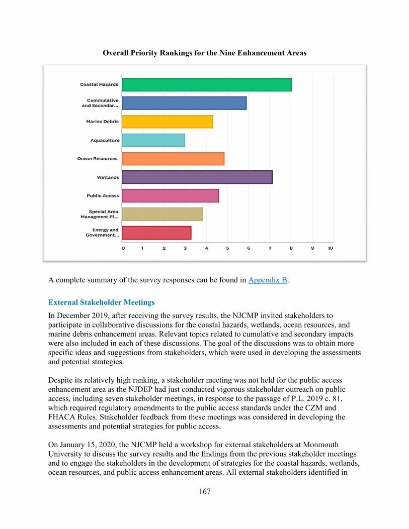
167
Overall Priority Rankings for the Nine Enhancement Areas
A complete summary of the survey responses can be found in Appendix B. External Stakeholder Meetings In December 2019, after receiving the survey results, the NJCMP invited stakeholders to participate in collaborative discussions for the coastal hazards, wetlands, ocean resources, and marine debris enhancement areas. Relevant topics related to cumulative and secondary impacts were also included in each of these discussions. The goal of the discussions was to obtain more specific ideas and suggestions from stakeholders, which were used in developing the assessments and potential strategies. Despite its relatively high ranking, a stakeholder meeting was not held for the public access enhancement area as the NJDEP had just conducted vigorous stakeholder outreach on public access, including seven stakeholder meetings, in response to the passage of P.L. 2019 c. 81, which required regulatory amendments to the public access standards under the CZM and FHACA Rules. Stakeholder feedback from these meetings was considered in developing the assessments and potential strategies for public access. On January 15, 2020, the NJCMP held a workshop for external stakeholders at Monmouth University to discuss the survey results and the findings from the previous stakeholder meetings and to engage the stakeholders in the development of strategies for the coastal hazards, wetlands, ocean resources, and public access enhancement areas. All external stakeholders identified in
168
Appendix A were invited to attend. The input received during this meeting was considered in the development of the strategies for these four enhancement areas.
Public Comment General public participation in the assessment and strategy process was provided through review and comment on the draft of this document. The NJCMP provided public notice, made the Section 309 Assessment and Strategy document publicly available, and ensured that a minimum 30-day public comment period was provided. The NJCMP received comments from The Nature Conservancy, Clean Ocean Action, the Pew Trust, Maurice River Township, and the New Jersey Department of Transportation. In response to these comments, the NJCMP modified the draft document. A general summary of the comments received and the NJCMP’s responses follows. The full public comments and NJCMP responses are available upon request. General Summary of Public Comments and NJCMP Responses The majority of the comments expressed overall support for the draft Assessment and Strategy while providing suggestions for refining and/or implementing the proposed strategies. However, a few commenters voiced concerns with the strategies and/or with the NJCMP’s prioritization of the nine enhancement areas. Clean Ocean Action (COA) disagreed with the NJCMP’s prioritization the special area management plans and energy and government facility siting enhancement areas and proposed specific strategies for these enhancement areas, which included the development of an Ocean SAMP and the creation of a comprehensive plan for the development of offshore wind resources, respectively. With respect to the development of an Ocean SAMP, the NJCMP takes a broader approach to coastal management through targeted regulations. The CZM Rules at N.J.A.C. 7:7 include robust use and resource rules that serve to protect coastal uses and resources wherever they are found throughout the coastal zone. Targeting specific geographic areas through SAMPs would be redundant with these regulations. As for creating a plan for developing offshore wind resources, the NJCMP acknowledges that this is a high priority for New Jersey. However, as explained in the Phase I Assessment for government and energy facility siting, planning for the development of offshore wind resources is currently being undertaken through various other mechanisms, including the Governor’s Executive Orders directing state agencies to address offshore wind developments, New Jersey’s Energy Master Plan, and the NJ PACT (Protecting Against Climate Threats) initiative to reduce emissions and adapt to climate change. Due to these ongoing offshore wind initiatives, the NJCMP ranked government and energy facility siting as a medium priority for the 2021-2025 Section 309 Assessment and Strategy. COA also questioned the need for the Science Policy Advisory Network (SPAN) under the ocean resources strategy, expressing concern with the lack of clearly stated goals for the SPAN as well as methods for accomplishing those goals. Science is crucial to developing policies that will
169
effectively address ongoing stressors and adequately protect New Jersey’s coastal resources. The goal of the SPAN is to ensure that all policy and regulatory decisions with respect to ocean uses and resources, as well as other issues impacting New Jersey’s coastal zone, are based on current, sound science. The first stage of this strategy includes establishing a framework for the SPAN. Therefore, the specific methods through which the SPAN will accomplish its goal will be determined as part of the strategy’s initial development phase. Maurice River Township also expressed concerns with several of the proposed strategies, specifically the wetlands and public access strategies. The township is worried that the wetlands strategy might lead to overly restrictive measures that could inhibit communities from maintaining their current economic status. While the NJCMP believes that ensuring wetlands can adapt to sea level rise is critical, the NJCMP understands the township’s concern regarding additional wetlands regulations and the need to balance environmental protection with the economic health of our coastal communities. For this reason, the NJCMP’s 2021-2025 Assessment and Strategy recognizes the importance of both wetlands and working waterfronts (see the ocean resources strategy), and the NJCMP will seek to balance any policies developed to enhance wetlands protections with policies and regulations that promote working waterfronts to ensure that water-dependent activities continue to thrive within New Jersey’s coastal communities. The township’s concerns with respect to the public access strategy include the possibility for new access being required at private properties, expensive public access maintenance requirements for municipalities, and negative impacts to wetlands. COA also urged the NJCMP to ensure that all public access improvements contain protections for important ecological resources. Public access projects along tidal waterways, including any that may result from the 2021-2025 Section 309 Public Access Strategy, must be constructed in accordance with the CZM Rules at N.J.A.C. 7:7, which ensure the protection of natural resources in New Jersey’s coastal zone. With respect to the concern with public access at private properties, the goal of the public access strategy is to identify public access opportunities. Most privately owned properties are unlikely to be considered viable opportunities for public access as the NJCMP cannot require access be provided at such properties except as a condition of a permit or authorization issued under the CZM or FHACA Rules. While the NJCMP may recommend public access projects on municipal land as a result of the public access assessment, such projects would only be proposed after consulting with the municipality. Additional comments that the NJCMP received on the draft Section 309 Assessment and Strategy provided suggestions for refining the proposed strategies. For the wetlands strategy, suggestions included expanding the proposed research to include shoreline change rates, considering ecosystem-based approaches that include shellfish and SAV restoration, and developing a special area designation for marsh migration areas. The NJCMP will consider all of these suggestions during implementation of the strategy. The suggestions for the wetlands strategy also included incorporating efforts to protect groundwater resources as sea levels rise and integrating the strategy with New Jersey’s current climate change efforts. Groundwater resource protections are being considered under the NJ PACT initiative, and the NJCMP intends to coordinate the wetlands strategy with that initiative.

170
For the coastal hazards strategy, suggestions for the proposed Regional Resilience Coordinator program included ensuring local officials understand the importance of coastal habitats, developing a comprehensive hazards assessment to inform the assistance provided by the coordinators, building regional networks, and educating municipalities about opportunities to implement nature-based flood mitigation solutions and develop local flood risk reduction policies. The NJCMP agrees with these suggestions. The specific guidance that will be provided by coordinators will be determined during the first year of the program and in consultation with NJCMP partners and stakeholders. Planning actions will be based on existing tools and resources as well as any new tools and resources that may be deemed necessary for development. Suggestions for refining the public access strategy included expanding the proposed public access assessment to include an environmental analysis to ensure that public access projects do not adversely impact New Jersey’s ecological resources. The NJCMP agrees with this suggestion and has modified the public access strategy accordingly. Another suggestion was to prioritize areas for public access that are adjacent to current or planned living shorelines and other coastal restoration projects in order to educate the public and foster community support. The NJCMP believes this could be beneficial and will consider the suggestion during the implementation of the strategy. Finally, under ocean resources, suggestions for refining the working waterfronts strategy included establishing working waterfront nodes, which the NJCMP will consider during implementation of the strategy, as well as evaluating existing and potential working waterfronts for suitability for a centralized offshore wind development port. On June 16, 2020, Governor Murphy announced plans to develop the New Jersey Wind Port, a first-in-the-nation infrastructure investment that will provide a location for essential staging, assembly, and manufacturing activities related to offshore wind projects on the East Coast.

171
Appendix A – External Stakeholders Industry/Trade Groups Association of Environmental Authorities of New Jersey - Peggy Gallos NAIOP, NJ - Diana Fainberg, Mike McGuinness and Richard Burrow Marine Trades association of New Jersey - Melissa Danko New Jersey Utilities Association - Karen Alexander (President) American Planning Association – New Jersey - Chuck Latini Jr. NJ Association of Flood Plain Managers - John Miller NJ Association of Realtors - Bruce Shapiro NJ Builders Association - David Fisher NJ League of Municipalities - Frank Marshal and Sue Howard NJ Business & Industry Association - David Brogan and Ray Cantor Amy S. Greene Environmental Association - Amy Greene Bowman Consulting Group - Tony DiLodovico BRS, Inc. - Leah Yasenchak Chiesa, Shahinian & Giantomasi, PC - Dennis Toft Dewberry - Michael Sears Giordano, Halleran & Ciesla - Michael Gross Inglesino, Webster, Wyciskala & Taylor, LLC - John Inglesino K&L Gates - John Spinello Langan Engineering & Environmental Services - Daniel Disario, Richard Burrow and Dave Gockel Maser Consulting - Raymond Walker

172
Nile and Associates - Joe Smith Princeton Hydro - Mark Gallagher Remington & Vernick Engineers - Frank Seney Shadel Environmental LLC - Bill Shadel Sokol, Behot & Fiorenzo - Niel Yoskin Storm Water Management Consulting, LLC - Joseph Skupien Taylor, Wiseman & Taylor - Bob Anastasia Toll Brothers - Benjamin Jogodnik Van Note Harvey Associates, PC - Thomas O’shea Wilentz, Goldman, and Spitzer - Jeffery Cappola Environmental/Non-Government Organization/Academic Alliance for a Living Ocean - Tom Beaty American Littoral Society - Alek Modjeski, Quinn Whitesall and Tim Dillingham ANJEC - Jennifer Coffey Barnegat Bay Partnership - Stan Hales and Marth Maxwell Doyle Clean Ocean Action - Cindy Zipf Coastal Ocean Coalition - Benson Chiles Rowan University College of Sciences & Mathematics - Cristian Botez (Dean) Delaware Bayshore Coucil - Benson Stowman and Meghan Wren Delaware River Basin Commission - Steve Tambini Delaware Riverkeeper - Tracy Carluccio and Maya VanRossum New Jersey Audubon Society - Kelly Mooij (Director of Government Relations), Susan Kraham, Eric Stiles and Drew Tompkins

173
Environmental New Jersey - Kevin Burkman and Dena Jaborska Conserve Wildlife Foundation of New Jersey - David Wheeler (Executive Director) Hackensack Riverkeeper - Captain Bill Sheehan Hudson River Foundation - Don Stitzberg Hudson Riverkeeper - Paul Galley Hudson River Waterfront Conservancy - Helen Monague and Donald Stitzberg Jacques Custeau National Estuarine Research Reserve - Lisa Auermuller Lower Raritan Watershed Association - Heather Fenyk Metropolitan Waterfront Alliance - Roland Lewis New Jersey Coastal Coalition - Edward Mahaney NJ Future - Chris Sturm and Tanya Rohrbach NJ Sierra Club - Kelly McNicholas New Jersey Conservation Foundation - Michele Byers and Emile DeVito (Science Manager) NJ Environmental Federation - Dave Pringle (Director) NJ Sea Grant Consortium - Claire Antonucci and Mike Danko NJ League of Conservation Voters - Henry Gajda and Ed Potosnak New York/New Jersey Baykeeper - Greg Remaud and Meredith Comi New York/New Jersey harbor Estuary Program - Robert Pirani Passaic River Coalition - Laurie Howard Partnership for the Delaware Estuary - Kaitlin Collins, Kathy Kline, Danielle Kreeger, Josh Moody and Angela Padeletti Pew Trust - Zack Greenberg Plan Smart NJ - Ann Brady (Executive Director) and Dianne Brake (President) Raritan Headwaters - Cindy Ehrenclou
174
Raritan Riverkeeper - Bill Schultz Rutgers University - Marjorie Kaplan, Bill Sciarappa and Dave Bushek Rutgers University - Edward J. Bloustein School of Planning and Public Policy - Jean Herb Stevens Institute of Technology - Jon Miller and Amy Williams Stockton University - Stewart Farrell, Kimberly McKenna, Brad Smith and Christine Thompson Stony Brook Millstone Watershed - Jennifer Coffey and Jim Waltman Surfrider Foundation - Joe Coakley Sustainable New Jersey - Chris Badurek, Marney Kimmel and Linda Webber The College of New Jersey - Randy Solomon The Leadership Group - Regina Podhorin The Nature Conservancy - Patricia Doerr, Stacy McCormack and Thomas Flynn Monmouth University – Urban Coast Institute - Tom Herrington and Tony MacDonald The Wetlands Institute - Lenore Tedesco Waterfront Alliance - Kate Boicourt Rutgers University – School of Engineering, Department of Civil and Environmental Engineering - Perumalsamy Balaguru Inter-Agency NJ Department of Community Affairs - Donna Rendeiro, Office of Smart Growth - Maria Connolly NJ Department of Health - Virginia Wheatley Delaware Valley Regional Planning Commission - Chris Linn NJ Governor’s Office - Tricia Caliguire New Jersey Port Authority - Chris Zeppe

175
NJ County Planners Association - Linda Brennen NJ Department of Agriculture - Monique Purcell and Amanda Wenczel NJ Highlands Coalition - Julia Somers NJ Office of the Attorney General - Arthur Russo NJ Pinelands Commission - Larry Liggett and Ed Weingrowski NJ Sports & Exposition Authority - Marcia Karrow and Terry Doss NJ Water Supply Authority - Beth Gates NJ Department of Transportation - Joseph Sweger and Elkins Green NJDOT - Office of Maritime Resources - Geneveive Boehm-Clifton North Jersey Transportation Planning Authority - Jeff Perlman New York/New Jersey Port Authority - Marc Helman Regional Plan Association - Carlos Rodrigues South Jersey Transportation Planning Organization - Jennifer Marandino South Jersey Transportation Authority - Samuel Donelson NJ Department of State – State Planning Commission - Joy Farber and Steven Karp NJ State Police - Chris Testa Federal Natural Resources Conservation Service - David Lamm US Geological Survey - Rick Kropp US Environmental Protection Agency - Dan Montell US Fish and Wildlife Service - Eric Shading, Steve Mars and Ron Popowski NOAA - Kara Meckley, Sean Corson, Chris Doley, Pat Montanio, Carl Alderson, Elain Mahoney, Randall Schneider, Darlene Finch and Karen Greene

176
US Army Corps of Engineers - Peter Weppler, Monica Chasten (Philadelphia District), Mike Hayduk (Philadelphia District), and Rosita Miranda (NY District) US Department of Agriculture - Rob Tunstead FEMA - Kelly Pflicke Local Government Atlantic County Department of Planning - John Person (Deputy Director) Cape May County Chamber of Commerce - Vicki Clark and Steve Morey Maurice River township - Ken Whildin Mercer County Soil Conservation District - William Brash Middlesex County, Department of Planning - Mirah Becker (Supervising Planner) Borough of Monmouth Beach - Sue Howard Somerset County Planning Division - Laurette Kratina
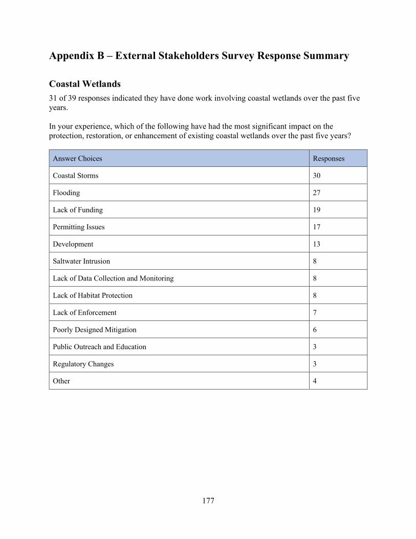
177
Appendix B – External Stakeholders Survey Response Summary Coastal Wetlands 31 of 39 responses indicated they have done work involving coastal wetlands over the past five years. In your experience, which of the following have had the most significant impact on the protection, restoration, or enhancement of existing coastal wetlands over the past five years?
Answer Choices Responses
Coastal Storms 30
Flooding 27
Lack of Funding 19
Permitting Issues 17
Development 13
Saltwater Intrusion 8
Lack of Data Collection and Monitoring 8
Lack of Habitat Protection 8
Lack of Enforcement 7
Poorly Designed Mitigation 6
Public Outreach and Education 3
Regulatory Changes 3
Other 4

178
Over the next five years, what actions can New Jersey’s Coastal Management Program take or participate in to more effectively protect, restore, or enhance existing coastal wetlands and/or encourage the use of living shorelines?
Answer Choices Responses
Increased Funding 32
Collaborative Planning 22
Best Management Practices Guidance 20
Demonstrations/Pilot Programs 20
Regulatory Changes 15
Green Infrastructure Design and Implementation Training 15
Data Collection and Monitoring 12
Outreach and Education 12
Scientific Research 11
Enforcement Action 4
Other 4

179
Coastal Hazards 32 of 38 responses indicated they have done work involving coastal hazards over the past five years. In your experience, what have been the most significant challenges to the prevention or reduction of risk from coastal hazards over the past five years?
Answer Choices Responses
Lack of Funding 23
Development/Redevelopment in Hazard Areas 20
Lack of Demonstrations/Pilot Projects 15
Lack of Regional Planning and Mapping 14
Lack of Design and Implementation of Alternative Shorelines 13
Lack of Data on Performance/Effectiveness 10
Lack of Hazard Training and Education for Local Governments 9
Lack of Community Planning Assistance 8
Lack of Hazard Mapping and Planning 7
Regulatory Changes 5
Lack of Data Collection, Assessment, and Monitoring 4
Lack of Outreach and Education 4
Lack of Scientific Research 3
Other 6

180
In your opinion, which of the following represent the greatest opportunities for enhancing New Jersey’s Coastal Management Program over the next five years in order to prevent, or significantly reduce risk from coastal hazards?
Answer Choices Responses
Elimination/Management of Redevelopment/Development in Hazard Areas 20
Additional Funding Opportunities 16
Alternative Shoreline Stabilization Methodologies 15
Sediment Management Planning 15
Restoration/Mitigation of Natural Resources 14
Strengthen/Renovate Existing Shoreline Protection Structures 13
Regional Resilience/Hazard Mitigation Planning 13
Ecological Solutions to Community Hazards 12
Coastal Vulnerability Assessment 11
Statewide Adaptation Planning 11
Community Resilience/Hazard Mitigation Planning 10
Cost-Benefit Analysis 9
Education and Outreach 6
Development of Statewide partnerships 6
Research and Monitoring 5
Hazard Mapping 4
Special Area Management Plans (SAMPs) 2
Other 3

181
Public Access 25 of 39 responses indicated they have done work involving public access over the past five years. In your experience, what have been the top three challenges associated with public access to tidal waterways in New Jersey over the past five years?
Answer Choices Responses
State Regulations 11
Ease/Difficulty of Access 10
Number of Access Locations 9
Enhancement of Amenities 8
User Fees 7
Local Policies/Ordinances 6
Safety 5
Handicap Accessibility 5
Tidal Flooding Storm Events 4
Fishing Access 3
Signage 3
Education 3
Boating Accessibility 2
Swimming Access 0
Surfing Access 0
Other 5
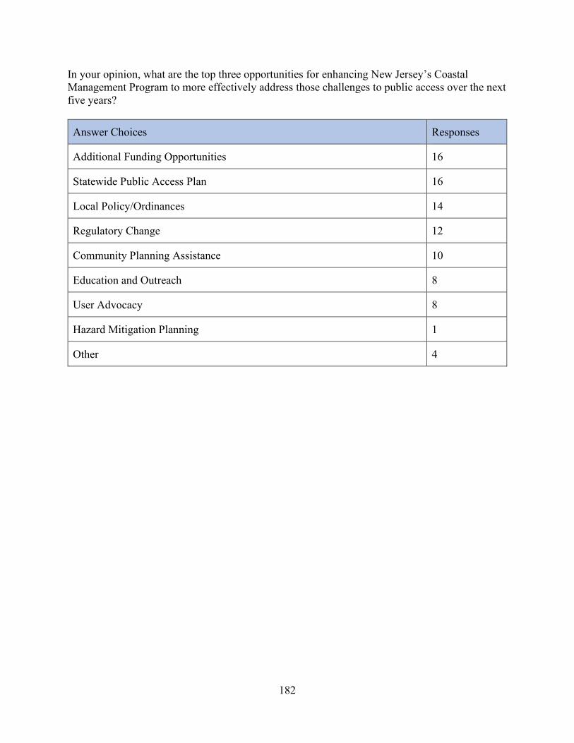
182
In your opinion, what are the top three opportunities for enhancing New Jersey’s Coastal Management Program to more effectively address those challenges to public access over the next five years?
Answer Choices Responses
Additional Funding Opportunities 16
Statewide Public Access Plan 16
Local Policy/Ordinances 14
Regulatory Change 12
Community Planning Assistance 10
Education and Outreach 8
User Advocacy 8
Hazard Mitigation Planning 1
Other 4

183
Marine Debris 26 of 39 responses indicate they have done work involving marine debris over the past five years. In your experience, which of the following have been the three most significant issues associated with managing uses and activities that contribute to marine debris over the past five years?
Answer Choices Responses
Education on Sources of Marine Debris and Prevention 15
Stormwater Infrastructure 14
Combined Sewer Overflows 12
Funding for Recycling and/or Waste Management 9
Coastal Storms 8
Monitoring Sources of Water Based Debris 8
Monitoring Sources of Land Based Debris 7
Waste Management at Beaches 7
Recycling Rates 2
Other 4

184
In your opinion, what are the top three opportunities for enhancing New Jersey’s Coastal Management Program to more effectively address those marine debris issues over the next five years?
Answer Choices Responses
Education and Outreach 19
Increased Enforcement of Existing Waste Management Laws 13
Increased Waste Disposal Options at Public Access Sites 13
Regional Partnerships 8
Regulatory Changes 7
Mapping Stormwater Infrastructure 7
Demonstration/Pilot Programs 6
Other 5

185
Cumulative and Secondary Impacts 24 of 38 responses indicated they have done work involving cumulative and secondary impacts over the past five years. In your experience, which of the following have been the top three challenges associated with the assessment and control of the cumulative and secondary impacts of coastal growth and development on New Jersey’s coastal resources over the past five years?
Answer Choices Responses
Development and Sprawl 21
Lack of Funding 19
Lack of State Planning 10
Lack of Resource Protection Standards 9
Existing State Regulations 6
Water Use 6
Identification of Non-Point Source Pollution 3
Identification of Point Source Pollution 1
Other 5

186
In your opinion, what are the top three opportunities for enhancing New Jersey’s Coastal Management Program to more effectively address those cumulative and secondary impacts over the next five years?
Answer Choices Responses
Comprehensive Planning Program for Coastal Communities 19
Programs to Retrofit Existing Developments Storm Water Infrastructure 13
Adoption of a State Plan 11
Identification of Critical Areas for Resource Protections 11
Additional Funding 11
Changes to the Coastal Area Facility Review Act (CAFRA) 9
Changes to the Coastal Zone Management Rules (CZM) 5
Changes to the Flood Hazard Area Control Act Rules 4
Cumulative Impacts Mapping 4
Changes to Stormwater Management Rules 3
Data Collection, Assessment and Monitoring 3
Identification and Mapping of Stormwater Infrastructure 3
Changes to the Water Quality Management Planning Act Rules (WQMP) 1
Other 4

187
Special Area Management Plans (SAMPs) 1 of 38 responses indicated they have done work involving SAMPs over the past five years. What areas of New Jersey’s coastal do you believe could benefit from a SAMP?
Answer Choices Responses
Barnegat Bay 13
Delaware Bayshore 11
State Waters in the Atlantic Ocean 8
Raritan Bay 8
Passaic River 5
Newark Bay 5
Navesink River 5
Maurice River 5
Shark River 2
Other 6
In your opinion, what are the top three opportunities for enhancing New Jersey’s Coastal Management Program to identify areas in need of special area designation over the next five years?
Answer Choices Responses
Regional Partnerships 18
Increased Funding 18
Resource Assessment and Characterization 13
Local Policy and Ordinances 11
Regulatory Changes 7
Other 4

188
Ocean Resources 14 of 37 responses indicate they have done work involving ocean resources over the past five years. In your experience which of the following have had the most positive impact on New Jersey’s ability to plan for ocean resources over the past five years?
Answer Choices Responses
Commercial and Recreational Fishing 8
Dredging 8
Offshore Development 6
Stormwater Runoff 6
Recreational Uses 6
Marine Transportation 4
Invasive Species 3
Land-based Development 2
Aquaculture 2
Coastal Hazards 2
Sand/Mineral Extraction 1
Ocean Acidification 0
Other 2

189
Which of the following have had the most negative impact on New Jersey’s ability to plan for ocean resources over the past five years?
Answer Choices Responses
Stormwater Runoff 14
Land-based Development 10
Coastal Hazards 8
Ocean Acidification 6
Invasive Species 5
Marine Transportation 3
Dredging 3
Commercial and Recreational Fishing 2
Offshore Development 1
Sand/Mineral Extraction 1
Aquaculture Recreational Uses 0
Other 4

190
In your opinion, what are the top three opportunities for enhancing New Jersey’s Coastal Management Program to more effectively address those issues over the next five years?
Answer Choices Responses
Regional Ocean Planning Initiatives 15
Collaborative Planning 11
Additional Funding Opportunities 10
Regulatory Changes 7
Best Management Practices Guidance 7
Data Collection, Assessment and Monitoring 6
Scientific Research 5
Demonstration/Pilot Projects 5
Outreach and Education 4
Enforcement Action 4
Other 3

191
Energy and Government Facility Siting 14 of 37 responses indicated they have done work involving energy and government facility siting over the past five years. In your experience, which of the following have posed the greatest challenge to the siting of energy and government facilities over the last five years?
Answer Choices Responses
Ecological Resources 14
Commercial and Recreational Fishing 7
Coastal Hazards 7
Land-based Development 6
Offshore Development 4
Dredging 4
Recreational Uses 3
Invasive Species 1
Marine Transportation 1
Ocean Acidification 1
Aquaculture 0
Sand/Mineral Extraction 0
Other 4

192
Which of the following have most aided the siting of energy and government facilities over the last five years?
Answer Choices Responses
Offshore Development 6
Land-based Development 2
Commercial and Recreational Fishing 2
Recreational Uses 2
Marine Transportation 2
Aquaculture 1
Dredging 1
Coastal Hazards 1
Ecological Resources 0
Invasive Species 0
Sand/Mineral Extraction 0
Ocean Acidification 0
Other 4
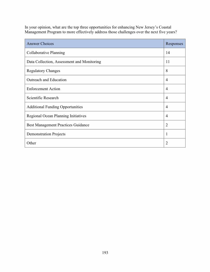
193
In your opinion, what are the top three opportunities for enhancing New Jersey’s Coastal Management Program to more effectively address those challenges over the next five years?
Answer Choices Responses
Collaborative Planning 14
Data Collection, Assessment and Monitoring 11
Regulatory Changes 8
Outreach and Education 4
Enforcement Action 4
Scientific Research 4
Additional Funding Opportunities 4
Regional Ocean Planning Initiatives 4
Best Management Practices Guidance 2
Demonstration Projects 1
Other 2

194
Aquaculture 7 of 37 responses indicated they have done work involving aquaculture over the past five years. In your experience, which of the following posed the greatest challenge to the siting of public or private aquaculture facilities in New Jersey’s coastal zone over the past five years?
Answer Choices Responses
Stormwater Runoff 9
Invasive Species 5
Land-based Development 4
Recreational Uses 3
Dredging 3
Commercial and Recreational Fishing 2
Coastal Hazards 2
Ocean Acidification 2
Offshore Development 1
Marine Transportation 0
Sand/Mineral Extraction 0
Other 8

195
In your opinion, what are the top three opportunities for enhancing New Jersey’s Coastal Management Program to more effectively address those issues over the next five years?
Answer Choices Responses
Data Collection, Assessment and Monitoring 9
Collaborative Planning 9
Regulatory Changes 7
Scientific Research 7
Additional Funding Opportunities 6
Outreach and Education 5
Demonstration Projects 4
Enforcement Actions 2
Best Management Practices Guidance 1
Regional Ocean Planning Initiative 1
Other 3