New Jersey: A Mirror on America, Sample Pages - Afton Publishing
39
by John T. Cunningham
Transcript of New Jersey: A Mirror on America, Sample Pages - Afton Publishing

by John T. Cunningham

1
New Jersey: A Mirror on America
by John T. Cunningham
Updated byPatricia Cunningham
Cover byJay Cunningham
A grant from the NJ Historical Society partially
underwrote the research and writing of this book — a
book worthy of New Jersey’s long and remarkable past,
the people who helped shape that past, and modern New
Jerseyans who continue to make history.
Publishing Co., Inc.PO Box 1399
Andover, NJ 07821-1399Toll Free 1-888-238-6665
Fax 973-579-2842www.aftonpublishing.com
Copyright © 2006by Afton Publishing Co., Inc.
All Rights ReservedISBN: 0-89359-033-9
For Preview Only!

2
This book depends as much on pictures as it does on words. The illustrations both amplify the text and demonstrate evolving styles of
illustrative materials. Picture captions expand the meaning of the text, rather than merely identifying the illustration.
Text, pictures, and captions thus are three meshing parts.It is difficult to obtain contemporary paintings or engravings of colonial and Revolutionary War New Jersey. A few are available including 1776 British drawings of New York harbor and the November scaling of the
Palisades to attack Fort Lee (both owned by the New York Public Library). Most of the colonial and Revolutionary War illustrations, however,
are from 19th century paintings, engravings, or books.Illustrative material derived from each period of history was used as
much as possible to provide the changing visual dimension of the 19th, 20th, and 21st centuries. Many 19th century engravings concerning New
Jersey were found in out-of-state journals, particularly Harper’s Weekly, Leslie’s Illustrated Weekly, Harper’s New Monthly Magazine,
The Century Magazine, and Scribners Monthly, all published in New York.Most of the illustrations in the text will be familiar to those thoroughly
conversant with New Jersey history. The bulk of the illustrations are from the author’s own collection of books, pictures, engravings, photographs, and
maps, compiled over a thirty-year period. Many are from the collection of Jay Cunningham. Others were copied, with permission, or purchased
from libraries or museums around the state particularly the State Library, The New Jersey Historical Society, Rutgers University Library, Newark
Public Library, Newark Museum, Morristown Library, Drew University, Monmouth County Historical Association, Camden Historical Society,
Princeton University Library, Trenton Public Library, Madison Public Library, and the Morris Museum of Arts and Sciences. Some materials
from the picture collection of the Library of Congress are included. Acknowledgement is made to all these institutions, and to many others
throughout the state, for their continuing interest in preserving the pictorial record of New Jersey.

3
Table of ContentsIntroduction I’m From New Jersey ................................................................................ 4 A Mirror On America .............................................................................. 5 Chapter One - Six Faces Of New Jersey .......................................................... 8 The Mountain Country ...................................................................... 9 Where Hills Rise High ......................................................................13 The Vital Corridor .............................................................................17 The Garden Strip ...............................................................................21 The Pine Barrens ...............................................................................25 A Golden Strand ...............................................................................29
Portfolio - The Original People .............................................................................. 33
Unit II - A Nation Of Immigrants ...................................................... 36 Chapter Two - New Holland And New Sweden .......................................38 Chapter Three - Trouble In The Jerseys .....................................................52 Portfolio - Life Doth Pass ........................................................................ 69 Chapter Four - Slow Road To Independence ............................................74 Chapter Five - World Turned Upside Down .............................................90
Unit III - Can This Nation Long Endure? ..........................................116 Chapter Six - The Fight To Survive ........................................................118 Portfolio - New Jersey Portrait: 1842 ..................................................... 141 Chapter Seven - Search For The Good Life ............................................144 Chapter Eight - Shades Of Blue And Gray ............................................164
Unit IV - The Hectic Half Century ....................................................186 Chapter Nine - The Tracks Of Change ...................................................188 Chapter Ten - Urbanizing The Garden State ..........................................210 Portfolio - Morristown’s Millionaires ..................................................... 230 Chapter Eleven - A State In Ferment .....................................................232
Unit V- Footsteps To A World Entwined ...........................................256 Chapter Twelve - The Clouds Of War ....................................................258 Chapter Thirteen - Through A Glass, Darkly ..........................................284 Chapter Fourteen - Survival In An Urban Land .....................................308 Chapter Fifteen - Adapting To A Changing World ................................328
Index ................................................................................................ 348
Featured Maps
Six Faces of New Jersey ............... 8Mountainland ............................ 9Highlands .................................13Vital Corridor ...........................17Garden Strip .............................21Pine Barrens ..............................25The Shore ..................................29Van der Donck map of 1656 .......44
North and South Rivers .............50East-West Jersey Lines ...............60Colonial NJ Counties ................76NY - NJ Border “War” ...............79NJ in the Revolution ..................93Canals Across New Jersey ........13019th Century Counties ............139Highlands Preservation ...........345
State of New Jersey ..................352

4
Each day hundreds of thousands of visitors speed across New Jersey’s narrow waist. Their visits usually last exactly as long as it takes a train or automobile to run between New York and Philadelphia.
Few tarry, but they think they see New Jersey: a factory-lined flatland, characterized by smokestacks, steel rails, and express highways. Such a land is easy to forget.
Occasionally New Jerseyans encounter these visitors, say in New England, where great numbers of New Jersey people go each summer in search of change and quiet. The casual question, “Oh, you’re from Jersey?” can put the New Jerseyan on guard. He or she is uneasily aware that the other probably means no compliment.
I know. As a native of New Jersey I once found myself constantly on the defensive explaining, for instance, whence the nickname “Garden State.” I usually failed, because I, too, knew little of the real New Jersey.
Then the State became for me a full-time job. To my surprise and delight I found the land beyond the railroad tracks well worth the knowing.
It was this simple. My newspaper, the Newark News, assigned me to write on New Jersey’s history and vitality. I am still at it (although the News has disappeared) and I am not on the defensive!
The years have taken me across every one of New Jersey’s 7,836 square miles, through hundreds of factories, across thousands of acres of farmland, into the offices of more than thirty college presidents, and along one hundred and twenty-seven miles of the Jersey Shore in every season of the year.
I’ve seen giant machines spew forth beer bottles and bridge cables, and I’ve watched painstaking fingers make a gold brooch. I’ve seen corn picked under floodlights at 4 AM, and I’ve seen Miss America crowned at midnight. I’ve been with muskrat trappers in the lonely Salem County marshlands, with track walkers in the crowded Hudson County railroad yards, with an orchid grower inspecting his seemingly endless hothouses, with farm boys driving cows homeward on deserted Sussex County roads.
Giant trucks hem me in on the superhighways, but I know country lanes that lead to mountains and back roads that end at Atlantic beaches. Along these roads I’ve seen maple trees tapped for syrup in the spring, blueberries plucked in summer, cranberries harvested in fall.
If I despair at weekend traffic, I try to remember that New Jersey has been a pathway for more than three hundred years, and was one of the most strategic, most fought over, of the Thirteen States in the Revolution.
Certainly I neither scorn nor dismiss the familiar view of New Jersey from a train window. Those factories, rail yards, and crowded highways all add up to economic importance, even if they obscure the fact that off beyond eye’s view there is both quaintness and charm for the finding.
JOHN T. CUNNINGHAMReprinted from an article
in National Geographic Magazine
I’m From New Jersey
5
A Mirror On AmericaNew Jersey has been called “the Little Giant,” but
that cannot obscure the fact that it is tiny. Much said or written about the state must be viewed against that fact.
Only Hawaii, Connecticut, Delaware, and Rhode Island (in that order) are smaller. Alaska is seventy-five times as large; Texas is thirty-four times as big. If the United States were to be divided into states all the same size as New Jersey, there would be 416 rather than fifty stars on the American flag.
The square miles are not impressive. One county in California — San Bernardino — is two-and-a-half times as large as New Jersey — one county! Lake Superior is four times as big; Yellowstone National Park is almost half as large.
So, New Jersey scores no points in boasting about its size.
How, then, can this state expect to be appreciated among sister states? The answer lies in one word: variety.
New Jersey is varied in geography, climate, in-dustry, and recreational opportunities. It is varied in history, politics, and modern problems. The story of New Jersey reflects, in miniature, much of the story of the United States.
Thus, to know New Jersey is to begin to know the story of the nation and the world. There is no better place to start, no better mirror on America.
Yet, United States history seldom gives New Jersey its due. Colonial history is traditionally told and retold in terms of settlements in Virginia and New England. The American Revolution is usually a retelling of patriot leaders in Massachusetts and Virginia.
United States history tells of a nation using changing sources of power, from water wheels to steam, to create an industrial nation. Railroads rolled westward, to weld together the states into a nation that stretched from the Atlantic to the Pacific. North fought South to preserve that nation.
After the Civil War, European immigrants flocked to these shores to give muscle and talents to both in-dustry and agriculture. Inventors turned their imagi-nations loose.
War ravaged the twentieth century world, completely involving the United States. Two wars in Europe and conflicts in Korea and Vietnam killed
the old dream of isolation.Changes swept through twentieth century Amer-
ica. Trucks and automobiles nudged aside the rail-roads. People fled outward from the cities, leaving festering troubles behind. Soon enough, the “country life” also bogged down in traffic, pollution, crowding, and taxes.
By 1976, when the United States paused to com-memorate the two-hundredth anniversary of the United States Constitution, this nation had become urban. Challenges beset nearly all the land: pollution of air and water, traffic snarls, declining cities, rising taxes, diminishing fuel supplies, soaring inflation, and the evident need to insure human rights for all people.
That, in brief, is the dramatic story of the United States. It is also the story of New Jersey. This is the point: History happened here. Often it happened here first.
Location is the key to the exciting fullness of New Jersey’s history. The state was destined by nature to be a midway state — wedged between the two finest natural harbors on the East Coast, between New York City and Philadelphia, between New England and the South.
That placement also is the chief reason why New Jersey’s leading role in nearly every major historical movement tends to be omitted from national accounts of this nation’s rise and development.
New Jersey’s historical importance, as well as its modern vigor, unquestionably stems from New York City and Philadelphia. Both have from earliest days influenced the state’s economy, culture, and patterns of living. Those cities also have always placed New Jersey in shadow.
Eastern New Jersey has revolved around New York; western New Jersey has been a satellite of Philadelphia for nearly three hundred years. In colonial days there actually were two colonies, East Jersey and West Jersey — and evidences of that deep split are still obvious.
To understand New Jersey, recognize that there really are two “Jerseys”: “North Jersey” and “South Jersey.” Neither appears on a map, but the division is almost as real as if there were a political boundary drawn from Burlington to Sandy Hook. North Jersey relies on New York City for its focus. South Jersey
A Mirror On America

6
finds its center in Philadelphia.North Jersey residents, say in Bergen, Passaic, or
Essex counties, know almost nothing about Glouces-ter, Salem, or Cumberland counties. Gloucester, Sa-lem, or Cumberland freely admit that they, in turn, seldom pay attention to the northern part of the state.
That polarization gives out-of-state cities the op-portunity to dominate state thought. Is it any wonder that New Jersey labors under a continuing “identity crisis”?
Out-of-state journalists and TV announcers con-centrate unimaginatively on the state’s crime and its politics (ordinary fare in all states, really). If they were to look beyond the obvious, they would find the state’s fascinating diversity.
Here are steep mountains, gentle rolling hills, cascading waterfalls, and long stretches of sandy white beaches. The state’s topography is ever-changing; from the blue water lakeland of northern New Jersey to the Pine Barrens of southern New Jersey; from the rock cliffs of the Palisades to the flat fertile acres along the lower Delaware River.
The varied land creates contrasting climates. Cum-berland County farmers plant onions in March while ice is still thick on Sussex County’s lakes. South Jersey farmers harvest spinach in early November, even as winter’s first snow dusts the Kittatinny Mountains.
This diversity of climate should be expected, for High Point is as far north as Hartford, Connecticut, and Cape May is on the same latitude as Washington, DC, even though High Point and Cape May are only 166 airline miles apart.
Winter temperatures have dipped to thirty-four degrees below zero and summer’s heat has soared to a record 110. About forty-five inches of rain falls each year on the state. Blizzards have dumped more than two feet of snow here in a single storm.
New Jersey’s prime story has been its ability to attract and hold many kinds of people. In colonial days, this was a place of Dutch, Swedes, English, Scots, Irish, and Germans. Later, immigrants swarmed here from eastern and southern Europe.
Two twentieth century world wars swelled the numbers of African American residents in the state, particularly in the cities. Here they joined other longtime African American residents, many of whom could trace their ancestors in this country back to pre-Revolution years.
Increasing numbers of Puerto Ricans, Cubans,
and other Hispanic people have made New Jersey a permanent home, particularly since World War II. New Jersey’s Asian American population has increased in more recent years.
All come to New Jersey to work and to improve their prospects for a good life. They come in search of a better life for their children.
That story of human diversity can easily be found throughout New Jersey in architecture, in foods, in national celebrations, in place names.
Sturdy stone colonial Dutch houses are not diffi-cult to find in Bergen County. Handsome eighteenth century brick houses are plentiful in Salem County, as are wooden pre-Revolution colonial mansions.
The contributions of varied people are found in the cathedrals, churches, and temples they have built — some small and simple, others large and ornate.
Differing national tastes in foods are evident —from kielbasa and wurst to lasagna, from egg roll to sweet potato pie and arroz con pollo. Varied national cultures are perpetuated in festivals, holidays, and folk dances.
Names underscore the immigrant influence. These tell of many national backgrounds in politics and box scores, on shop signs and in newspaper columns. No state knows a greater variety of people than New Jersey.
The twentieth century brought two world wars and “small wars” in far-off Korea, Vietnam, and Kuwait; a people gone lawlessly mad for alcohol in the 1920s; an economy sunk in the unprecedented Depression of the 1930s, a republic trying to find an adequate meaning of the word “liberty”; a nation that could set a man on the moon and yet find little money for its cities.
As the United States and New Jersey approached the twenty-first century, people were so dependent on computers they feared massive shutdowns of vital and emergency systems if the computers couldn’t handle “00” in a date. The shutdowns were averted; communication became increasingly efficient as more and more New Jerseyans connected with the rest of the world on the Internet.
The twenty-first century arrived with newly incredible perplexity. It brought with it a new kind of war and new challenges for the United States — and New Jersey — to find their places in the world in a new millennium.
New Jersey’s eight and a half million people now live in the most densely populated and most urban of

7
all the fifty states. Modern New Jersey mirrors a look into America’s future, for urbanization is the coming way of the nation. (Even Anchorage, Alaska, has a “flying traffic reporter.”)
Kenneth A. Gibson, former mayor of Newark, expressed the urban dilemma most clearly: “Wherever American cities are going, Newark will get there first.”
The former mayor might well have said, “Wherever America is going, New Jersey will get there first.” Urban America arrived in New Jersey long ago — with its noise, crowding, pollution, and problems, and its challenges and opportunity.
Encouragingly, much open land persists in New Jersey despite the spread of highways and the sprawl of cities. This is yet a place of hardwood forests and dense pine woodlands. Perhaps the most startling little-known fact about “urban” New Jersey is that about forty-two percent of the state is still covered by forests.
Is New Jersey really the “Garden State”? New Jersey has lost much of its farmland and will continue
to lose more, but the NJ Farmland Preservation Program assures the protection of many farmland acres.
New Jersey correctly can be called “the urban laboratory of America.” This urban state yet has the chance to prove that — given enough imagination and dedication — humans can live in harmony with their environment.
Possibly the “laboratory” might prove that it can’t be done. Either way, the choice will be made throughout the nation — and New Jersey will be forced to choose first. New Jersey again will make history.
So, look into the mirror of New Jersey. Find re-flections of the past — not always glorious, not al-ways noble, for history is far more than merely the triumphs of yesteryear. Find, as well, the emerging face of America’s future.
The mirror might or might not say that New Jersey is the fairest of them all, yet its reflection of America will fascinate in all its complexity, in all its changing moods.
The Imaginary “Identity Crisis”The easiest way for a comic or a TV “news” announcer to get a
laugh (in New York City or Philadelphia, at least) is to regard New Jersey as a barren wasteland inhabited by gangsters, simpletons, and polluters. Woody Allen once observed that “a certain intelligence governs our universe, except in certain parts of New Jersey.” New York Magazine called the Holland Tunnel New Jersey’s “road to civilization.” New York TV commentators show visible amusement at the very mention of New Jersey.
New Jersey politicians, believing what the across-the-river critics repeat, long have dwelled on the need to cure what they label an “identity crisis.”
Apparently the low out-of-state opinions do not depress New Jerseyans. Surveys show that state’s residents are very high on New Jersey.
Bill Canfield, retired Newark Star Ledger cartoonist, interpreted people-versus-the-politicians in the drawing to the left. The Star Ledger commented editorially: “Perhaps the politicians who dwell on this dreary, negative phrase (identity crisis) are too far removed from the people... and reality.”
The media has done much in recent years to “promote New Jersey.” A radio station, NJ 101.5 (97.3 in South Jersey); a magazine, New Jersey Monthly; and TV Stations, NJN and News 12 New Jersey, all devote themselves to covering New Jersey news and issues. New Jersey still, however, often finds itself a ready target for a good laugh.

8
Little New Jersey offers lakeland ice boating and ocean surfing, thoroughbred horse farms and pounding factories, lonely swamplands and crowded cities. It is a place of wild orchids and cranberry bogs, flat vegetable fields and rolling dairylands, oak forests and pine woodlands.
This is a state of rugged mountains and blue water lakelands, thundering waterfalls and salt water bays, craggy rock ridges cast up by ancient volcanoes, and serene valleys gouged out by glaciers in times long past.
New Jersey is where the Palisades rise magnificently above the Hudson River, and where the Delaware Water Gap is a reminder that in time a river can cut relentlessly through the hardest stone. This is a place of Sandy Hook and Cape May, the Great Swamp and Brigantine National Wildlife Refuge, Island Beach and High Point Park.
Nature worked hard to fashion this land called New Jersey. Sometimes it used the violence of pre-historic times, more often it smoothed the surface in a gentle day-to-day wearing of water and wind against the earth. Nature’s work is never done; each day the beaches of the Jersey Shore are arranged and rearranged by ocean tides. Often, too, the beds of rivers are changed, if ever so slightly, by raging rainstorms.
New Jersey, with a terrain that varies from mountains to seashore, is in miniature a cross-section of the varied landscape of the nation. Such a varied land is not easy to know, yet in knowing New Jersey there comes understanding of the way landforms affect people — and the way people adapt to the land.
There is one approach to knowing New Jersey’s land. The state can be readily sectioned into six parts — to the north, mountainland, highlands; the intense corridor of cities across the middle; and to the south, prime farmland, the Pine Barrens, and the Jersey Shore.
Those are the “six faces” of New Jersey. Although they blur into one another on the edges, each is very different from the others.
Chapter One - Six Faces Of New Jersey
For Preview Only! For Preview Only! For Preview Only! For Preview Only!

9
Winter pounds furiously at the northwest corner of New Jersey, jamming thermometers in the Kit-tatinny Mountains down into the 20s — below zero. Snow sweeps across the peaks and valleys. Ice slicks the roads. Some years, winter begins early in Novem-ber; some years the cold seems never to end.
Then spring arrives. Cattle return to graze on the slopes. Streams swollen by melting snow coil down the rocky slopes. Wildcats sound their calls in the warm-ing nights. By day, timber rattlesnakes sun themselves on the rocky eastern face of the mountains.
This is mountain country all right, rugged and wild, still unconquered.
Seen from a distance, the Kittatinnies are doubly remarkable. The long crest seems level and usually appears dark blue in color. The hue is so distinct that early settlers called these the “Blue Mountains,” the name by which the formation still is known in Pennsylvania. (In New York, the ridge bears the Indian name, Shawungunk.)
The mountain averages about 1,600 feet above sea level along its entire length, although it rises to 1803 feet at High Point, the state’s loftiest height.
Kittatinny Mountain has resisted change. Only two major roads cross the slopes in the thirty-six mile-long mountain. Route 206 follows an old Indian trail through Culvers Gap. Route 23 twists up the mountain in sweeping curves to reach High Point.
From the monument atop High Point, the eye takes in a dense green hardwood forest falling away in every direction — north, deep into New York State; west, to the distant Pennsylvania horizon; and east and south through Sussex and Warren counties.
That rich green woodland endures because the state owns two-thirds of the ridge between High Point and Delaware Water Gap. State-owned High Point Park and Stokes State Forest provide wide varieties of outdoor recreation. Worthington State Park, adjacent to the Gap, is also in state hands. It is not developed, but resolute hikers can climb the steep
New Jersey’s highest spot — 1,803 feet above sea level — is defined by a 220-foot-tall granite monument. The impressive monument is 30 feet square at the base and can be seen from 20 miles away.Huge slabs of rock, folded in layers across the slope of the Kittatinny Mountains near Pahaquarry, typify New Jersey’s rugged, unconquered mountain country.
The Mountain Country
For Preview Only! For Preview Only! For Preview Only! For Preview Only!

10
The famed Delaware Water Gap (above), gouged down 1,100 feet by the river, has changed little since the engraving below was sketched in 1872.
For Preview Only! For Preview Only! For Preview Only! For Preview Only!

11
mountainside to see Sunfish Pond sparkling atop the ridge.
Monument To Powerful Forces
More than 200 million years have gone into mold-ing the Kittatinnies. Some geologists maintain that the original Appalachian Mountains (of which the Kittatinny ridge is part) rose 30,000 feet above sea level topping the modern Himalaya Mountains, high-est in the world.
Other geologists argue that continuing erosion kept the ancient slopes to a height not much greater than the present. Either way, the Kittatinnies are a lasting monument to crunching forces that long ago shattered thick layers of rock and folded them up-ward into mountains.
The tremendous forces that make a mountain are revealed in Delaware Water Gap, the scenic wonder of the Kittatinnies and one of the best-known natural formations in the United States.
Shared by New Jersey and Pennsylvania, Dela-ware Water Gap is evidence of the subtle strength of water. Here, over millions of years of time, the river wore constantly at the hard rock. Now the Gap is 1,100 feet deep. The Gap’s walls show how the Kittatinnies were formed. The rock layers appear crumbled and folded by nature as if they had been so much taffy.
Hikers on the famed Appalachian Trail know the Kittatinnies best. That trail begins in Maine and wends 2,028 miles to the end in Georgia. The section through New Jersey is too arduous for most people, but a feel for the splendid walkway can be experienced easily at Sunrise Mountain in Stokes State Forest.
Sunrise Mountain really should be called “Sun-rise Lookout” for it is part of the Kittatinnies. Ap-palachian Trail hikers labor for miles over a boulder-strewn path to enjoy the view from Sunrise Mountain. Less athletic nature enthusiasts can drive up, park, and walk a few feet to get the same vista.
Valleys To Stir The Senses Below to the east spreads the beautiful Kittatinny
Valley, flat and broad as far as the Hamburg and Po-chuck mountains to the east. Tiny houses and barns dot the valley. Holstein cows, appearing as little more than specks in the distance, graze in the pastures.
The valley is dairyland, a place of red barns, white viewer
Water works its magic in the Kittatinnies, here in Buttermilk Falls splashing down the west slope.
For Preview Only! For Preview Only! For Preview Only! For Preview Only!
12
sees Culvers Lake, vividly blue against the emerald green of the fields.
West of the Kittatinnies, the Minisink Valley lev-els off to the Delaware River. Few settlers have called the valley home, yet tradition says that more than 300 years ago Dutch adventurers came to dig copper just north of Delaware Water Gap.
These Dutchmen struggled south from Kingston, New York in the 1650s. They built a trail through what they called a “howling wilderness” to carry their copper to market the long way around via Kingston. That trail is said to be the first long distance road in the New World. The copper mine site can still be seen, and the “Old Mine Road” is paved for modern travel.
Long unknown to most New Jerseyans, except oc-casional Sunday drivers on the Old Mine Road, the Minisink Valley became the battle ground for an epic struggle in the 1960s and the early 1970s between conservationists and the United States Government.
Fight For Minisink Valley
The battle for Minisink Valley began after the Army Corp of Engineers announced plans in 1960 to build a giant dam at Tock’s Island in the Delaware River. This would have created a huge reservoir north nearly to Port Jervis. The Corps moved in, bought properties, and leveled houses.
The Tock’s Island project would have served two worthwhile purposes. The reservoir would have sup-plied badly needed water for New Jersey, New York,
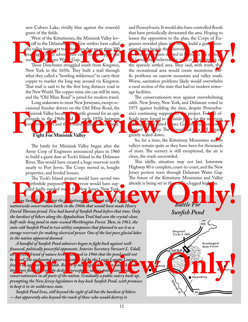
Tiny Sunfish Pond, atop the Kittatinny Mountains, stirred a classic nationwide conservation battle in the 1960s that would have made Henry David Thoreau proud. Few had heard of Sunfish Pond before that time. Only the hardiest of hikers along the Appalachian Trail had seen the crystal-clear, half-mile-long pond in state-owned Worthington Forest. Then, in 1961, the state sold Sunfish Pond to two utility companies that planned to use it as a storage reservoir for making electrical power. One of the last pure glacial lakes in the nation appeared doomed.
A handful of Sunfish Pond admirers began to fight back against well-financed, politically powerful opponents. Interior Secretary Stewart L. Udall, an avowed friend of nature lovers, warned in 1966 that the pond could not be saved. The undaunted conservationists, led by the Lenni Lenape League, fought on against heavy odds. Reams of mimeographed “Save Sunfish Pond” literature flooded across the desks of newspaper editors, politicians, and conservationists in all parts of the nation. Gradually a public outcry built up, prompting the New Jersey legislature to buy back Sunfish Pond, with promises to keep it in its wilderness state.
Sunfish Pond lives, still beyond the sight of all but the hardiest of hikers — but apparently also beyond the reach of those who would destroy it.
Battle For Sunfish Pond
and Pennsylvania. It would also have controlled floods that have periodically devastated the area. Hoping to lessen the opposition to the plan, the Corps of En-gineers revealed plans in 1965 to build a giant recre-ational area beside the reservoir.
Conservationists reacted in horror to the ecologi-cal havoc they believed the project would wreak on the sparsely settled area. They said, with truth, that the recreational area would create monstrous traf-fic problems on narrow mountain and valley roads. Worse, sanitation problems likely would overwhelm a rural section of the state that had no modern sewer-age facilities.
The conservationists won against overwhelming odds. New Jersey, New York, and Delaware voted in 1975 against building the dam, despite Pennsylva-nia’s continuing support for the project. Federal of-ficials were forced to set aside plans for the reservoir, although the United States Government now owns most of the valley. The recreational area will remain, greatly scaled down.
So, for a time, the Kittatinny Mountains and its valleys remain quite as they have been for thousands of years. The scenery is still exceptional, the air is clean, the roads uncrowded.
This idyllic situation may not last. Interstate Highway 80 is complete, coast-to-coast, and the New Jersey portion veers through Delaware Water Gap. The future of the Kittatinny Mountains and Valley already is being set in the traffic-clogged highway.
For Preview Only! For Preview Only! For Preview Only! For Preview Only!

13
Far across the valley, below Sunrise Mountain in the Kittatinnies, the Highlands start to rise. New Jersey began in those Highlands, formed more than two billion years ago when great boulders were pushed above the surface of ancient seas.
Looking east and south from Sunrise Mountain atop the Kittatinny Ridge, the eyes see a series of ir-regularly shaped, thickly wooded mountains on the far side of the valley. Those immediately in view are Pochuck Mountain and the Pimple Hills. In “Po-chuck” and “Pimple,” New Jersey’s Highlands begin.
It is fitting that these two first-seen parts of the Highlands are called “mountain’’ and “hills,’’ for the Highlands measure somewhere between mountains and high hills. The top Highland ridge rises 1,496 feet above sea level near Vernon. Other ridges, near Spruce Run and the Delaware River, are only about 500 feet.
Here, nearly two billion years ago, New Jersey rose from the sea.
Tremendous boulders were pushed slowly upward from the floor of the prehistoric sea. The boulders rose ever higher, until at last they peeped above the surface to form land. The oldest part of New Jersey — the Highlands — had appeared.
Nothing has pushed these stout Highlands aside, not in two billion years. Time rounded and smoothed the many high mountains, and then covered them
with forests. Passing centuries scoured out the valleys and carpeted them with green growth. Beneath the surface tidying up, the original hard rock remains.
The Highlands are part of a long range of similar-ly rounded mountaintops and deep valleys between northern New England and the South. Vermont visi-tors who see New Jersey’s Highlands have exclaimed, on first sight, “Why, this is like New England!”
In fact, New Jersey gets much the best of that highest possible Vermont accolade, for some of Ver-mont’s Green Mountains rise nearly 4,400 feet above sea level. It is not a totally undeserved compliment, however, for this is beautiful country.
Similarity to New England is most marked in winter, especially in Vernon, where one of the larg-est ski resorts in the East spreads over the slopes of Hamburg and Wawayanda mountains.
New England is blessed (from a skier’s viewpoint) with far more snow than New Jersey. But Mountain Creek Ski Area proprietors lessen the deficiency with snow-making machines that powder the Sussex County hillsides from as early as late November until sometimes early April.
Where Hills Rise High
For Preview Only! For Preview Only! For Preview Only! For Preview Only!
14
New Jersey’s Lakeland
Nearly every important New Jersey lake is cupped within the Highlands (excepting only Culvers, Owas-sa, and Swartswood, all nearby in the Kittatinny Val-ley). The largest Highland lake — and by far the larg-est in the state — is Lake Hopatcong, nearly seven miles long. The shoreline is cut by so many deep coves that the distance around Hopatcong is more than forty miles.
Lake Hopatcong was once two small ponds. A dam was built at the southern end in the 1830s to provide water for the Morris Canal, joining the ponds into one handsome jewel of a lake. The dam site is now Hopatcong State Park.
Nearly every lake in the Highlands is either ar-tificial or was partially enlarged by a dam. The chief exception is Green Pond. Despite the “pond” name, this is a deep, natural lake, more than two and a half miles long and up to fifty feet deep.
Several other lakes were created or expanded to supply water for the Morris Canal. Both Cranberry and Musconetcong were built solely for the canal.
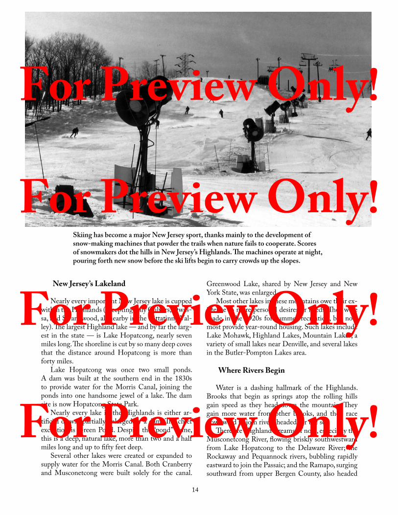
Skiing has become a major New Jersey sport, thanks mainly to the development of snow-making machines that powder the trails when nature fails to cooperate. Scores of snowmakers dot the hills in New Jersey’s Highlands. The machines operate at night, pouring forth new snow before the ski lifts begin to carry crowds up the slopes.
Greenwood Lake, shared by New Jersey and New York State, was enlarged.
Most other lakes in these mountains owe their ex-istence to more personal desires or needs. They were made in the 1920s for summer recreation, but now most provide year-round housing. Such lakes include Lake Mohawk, Highland Lakes, Mountain Lakes, a variety of small lakes near Denville, and several lakes in the Butler-Pompton Lakes area.
Where Rivers Begin
Water is a dashing hallmark of the Highlands. Brooks that begin as springs atop the rolling hills gain speed as they head down the mountain. They gain more water from other brooks, and then race downward to join rivers headed for the sea.
There are Highland streams of note, especially the Musconetcong River, flowing briskly southwestward from Lake Hopatcong to the Delaware River; the Rockaway and Pequannock rivers, bubbling rapidly eastward to join the Passaic; and the Ramapo, surging southward from upper Bergen County, also headed
For Preview Only! For Preview Only! For Preview Only! For Preview Only!

15
for the Passaic.A most unusual evidence of river origin occurs
at Hilltop Presbyterian Church on a Highland hill at Mendham. Rain that strikes the north roof of the church drains off into the Passaic River. Rain pat-tering on the southward shingles finds its way to the Raritan River.
Plentiful Highland streams attracted dam build-ers of another sort early in the late nineteenth and early twentieth centuries. Seeking ample water sup-plies for urban use, Newark and several other major northern New Jersey towns constructed reservoirs at Oak Ridge, Clinton, Canistear, and Wanaque to store Highlands water.
Jersey City also reached out for Highlands water, building its reservoir at Boonton early in the twen-tieth century. Much more recently, the State con-structed reservoirs at Spruce Run and Round Valley in Hunterdon County.
The Glow of Iron
Pompton Lake, begun when the Pompton River was dammed to provide water power for a pre-Revo-lution forge, introduces another element of the High-lands: iron. This was the most vital resource of these mountains for more than two hundred years.
Early settlers in Newark and Elizabeth, in about 1700, heard Indian tales of “Succysunny” (mean-ing “black stone”) found near what is now the town of Succasunna. Prospectors crossed the Highlands to seek the black stone in about 1710. Soon after, iron forges were built in “The Hollow’’ (modern Morristown) and at Hanover.
Within fifty years, forges and furnaces were started between Ringwood, near the New York State border, and Bloomsbury, in Warren County. These provided colonial ironware for arms during the Revolution. Ringwood, Oxford, and Dover became centers for ironmakers in the nineteenth and twentieth centu-ries. There was scarcely a place within the Highlands where fortunes did not at one time or another rise and fall with the flickering flames of the glowing iron furnaces.
The Highlands had everything that early iron-makers needed — plentiful supplies of good ore, am-ple forestland for fuel, limestone to hasten melting of the ore, and powerful streams to provide power for the forges. Forests were significant factors. It has been estimated that a single forge “fire” consumed one thousand acres of woodland annually.
Gradually the forge fires diminished, particularly after easily mined iron was discovered near Lake Su-perior in Minnesota in the 1870s. The western ore
Lake Hopatcong was surrounded by unexplored forests when this engraving was made in the 1850s, about 20 years after two small ponds were combined. The lake has retained the same size and shape ever since. Thousands of homes now line the shores and boats crowd the water, but Hopatcong remains beautiful.
For Preview Only! For Preview Only! For Preview Only! For Preview Only!

16
could be shoveled directly from the ground into wag-ons, rather than brought out laboriously from New Jersey mines deep under the surface.
Spurts of production in World War I and World War II were nothing more than temporary stimu-lants for the ironmakers. All the mines were either closed or on standby status by 1970. The Mt. Hope Mine, where a vertical shaft is sunk half a mile into the earth, announced in 1976 plans to reopen, but this never materialized. Two hundred years before, Mt. Hope helped supply arms to Washington’s army.
Paradise For Rock HoundsMention Franklin, New Jersey to geologists anywhere
and expect instant attention — for no area in the world has produced as many minerals as this Sussex County region.
Franklin won fame as one of the world’s foremost producers of zinc between 1848 and 1954. In that period, at least 212 different minerals were found at the site, including several never found anywhere else. Forty-two were first found at Franklin.
Many of Franklin’s minerals glow (or fluoresce) in a wide variety of colors under ultraviolet light, prompting the town to call itself “The Fluorescent Mineral Capital of the World.”
Science classes from schools and colleges regularly visit Franklin and nearby Ogdensburg. They tour the Franklin Mineral Museum and the Sterling Hill Mining Museum. Some prospect at the outdoor mineral dump.
Zinc mining at the Sterling Mine started in 1852 and continued until 1986. Now an historic site, the museum allows visitors to walk through underground tunnels, view fluorescent minerals, and see authentic mining artifacts.
You can also see some of Sterling Hill Mine’s 340 different kinds of minerals in the Hall of Geology at the Smithsonian Institution in Washington, DC.
Ironmakers may be only biding their time. Ore still buried in the Highlands is estimated to total as high as 600 million tons.
Mining is just another story of the past. The lake-lands no longer have huge summer boarding houses or the numerous public amusement parks of the early 20th century. Ice is no longer cut and loaded aboard long strings of freight cars for shipment to city res-taurants and hotels.
Instead, the Highlands have become places where people want to live. Interstate Highways 78, 80, and
287 pour streams of people out to their homes in the evening and take them back to work in the flatlands to the east the next morning.
Governor James McGreevey signed the Highlands Preserva-tion Act in August 2004. This law protects the resources of the Highlands, especially the drink-ing water that supplies more than half the state’s population.
Change doesn’t matter in the Highlands. An area with more than two billion birthdays can cope with anything that mere humans plan.
For Preview Only! For Preview Only! For Preview Only! For Preview Only!

17
New Jersey’s chief crossroads are in Middlesex County where the New Jersey Turnpike and the Garden State Parkway, both built in the 1950s, exchange traffic in a complex system of bridges, ramps, and toll booths.This exchange lies almost exactly between two of New Jersey’s “new” cities — Edison and Woodbridge.
Geography’s direct effect on people is seldom more clearly seen than in New Jersey’s twenty-mile-wide corridor between the Hudson and Delaware rivers. Two wide, deep rivers predestined great ports on ei-ther side; a level plain between the ports ensured that this area would vibrate with transportation and in-dustrial activity.
This is New Jersey’s vital corridor. This is where people live, work, attend college, seek culture, shop, conduct state government, and clog the roads with their automobiles and trucks.
This corridor contains every major New Jersey city, two-thirds of all its industries, most of its colleges and universities, most of the transportation network, and most of the research laboratories. More than half of all New Jerseyans dwell here, and here are most cen-ters of culture, the most important financial houses, and the state’s political pulse.
The corridor is not new. In 1880, when census
The Vidal Corridor
For Preview Only! For Preview Only! For Preview Only! For Preview Only!
18
takers first described New Jersey as urban, the area already contained about two-thirds of the people and about two-thirds of the industry.
There probably is no more busy, dynamic, confus-ing twenty-mile-wide strip of land in all the world than this avenue that runs from the George Wash-ington Bridge southwestward to Camden.
Rigid boundaries cannot be fixed, for this hectic path grows wider each year as people and industry force it outward. It spills westward into the foothills, south and east toward the level Coastal Plains.
Industry At The Fall Line
The corridor’s western portion is in the Piedmont (“foot of the mountains”). Including the Piedmont in the vital corridor is logical, since colonial industry be-gan here. Streams tumbling out of the Piedmont hills quickly were harnessed to power grindstones, saws, looms, and other machines in the lowlands.
That place where streams and rivers of the Pied-mont pick up speed then drop rapidly to sea level is called the “fall line.” This might include intermittent rapids, such as those at Little Falls, or a thundering cascade, such as the Great Falls at Paterson.
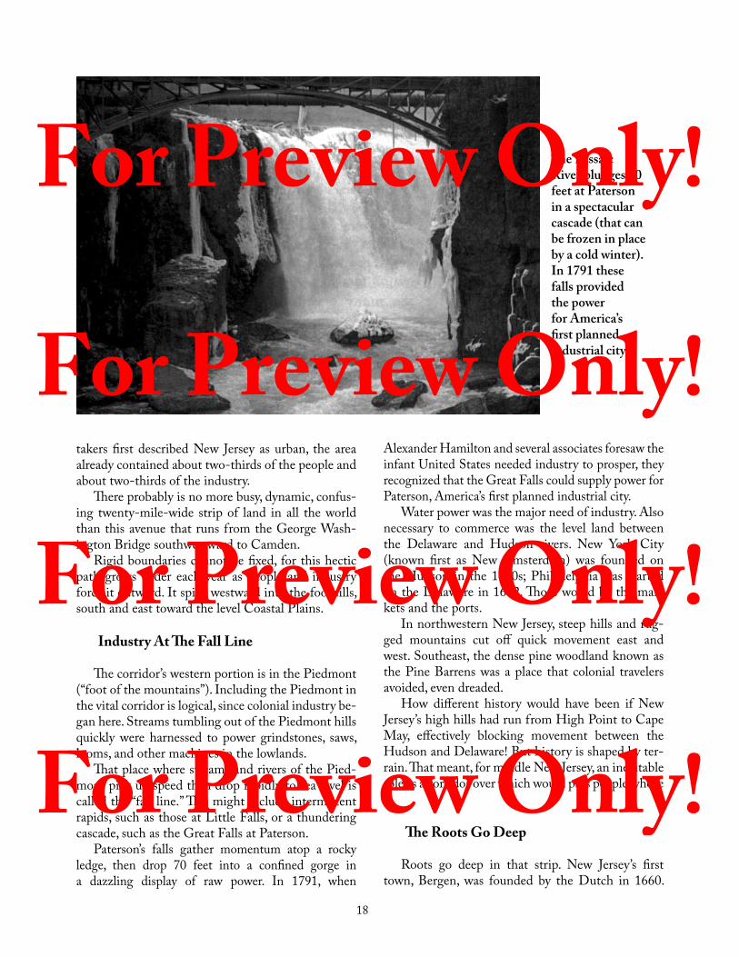
Paterson’s falls gather momentum atop a rocky ledge, then drop 70 feet into a confined gorge in a dazzling display of raw power. In 1791, when
The Passaic River plunges 70 feet at Paterson in a spectacular cascade (that can be frozen in place by a cold winter).In 1791 these falls provided the power for America’s first planned industrial city.
Alexander Hamilton and several associates foresaw the infant United States needed industry to prosper, they recognized that the Great Falls could supply power for Paterson, America’s first planned industrial city.
Water power was the major need of industry. Also necessary to commerce was the level land between the Delaware and Hudson rivers. New York City (known first as New Amsterdam) was founded on the Hudson in the 1620s; Philadelphia was started on the Delaware in 1682. Those would be the mar-kets and the ports.
In northwestern New Jersey, steep hills and rug-ged mountains cut off quick movement east and west. Southeast, the dense pine woodland known as the Pine Barrens was a place that colonial travelers avoided, even dreaded.
How different history would have been if New Jersey’s high hills had run from High Point to Cape May, effectively blocking movement between the Hudson and Delaware! But history is shaped by ter-rain. That meant, for middle New Jersey, an inevitable role as a corridor over which would pass people whose
The Roots Go Deep
Roots go deep in that strip. New Jersey’s first town, Bergen, was founded by the Dutch in 1660.
For Preview Only! For Preview Only! For Preview Only! For Preview Only!

19
Nearly 150 years later, Bergen became Jersey City. Elizabeth was founded late in 1664 as New Jersey’s first English-speaking town; Newark dates to 1666. Government began here; New Jersey’s first Assembly met in Elizabeth in 1668.
Control of the artery helped determine the win-ning of the American Revolution. The region saw constant conflict for five years.
Then the inventive dreamers came: John Stevens, who built America’s first railroad locomotive at Hoboken in 1826; John Philip Holland, a Paterson school teacher who made the first practical submarine in 1878; Thomas Edison, who perfected the electric light at Menlo Park in 1879; and the Rev. Hannibal Goodwin, who perfected flexible photographic film in his Newark parsonage in 1887.
Railroads ruled the corridor before 1850. Industry followed the rails, in bewildering complexity: ma-chine makers, metal refiners, food canners, furniture makers, textile weavers, clothing manufacturers; mak-ers of chemicals, oil products, explosives, and almost everything else known to humanity.
Twentieth and twenty-first century wonders are part of the story of this strip. Many of the pharma-ceutical advances since the 1920s were discovered here — vitamins, “wonder” antibiotics, sulfa drugs, and other disease killers. Flights into space were pio-neered in the corridor’s research laboratories.
This is a place of learning. Rutgers University, once confined to “the banks of the old Raritan” in New Brunswick now also has major campuses in Newark and Camden. Princeton thrives in Ivy League digni-ty in the middle of the corridor’s frantic pace. Seton
Here are views of three New Jersey cities: the Capitol complex in Trenton (left), downtown of the biggest city, Newark (below), and Camden’s Wiggins Waterfront Park along the Delaware River (lower right).
For Preview Only! For Preview Only! For Preview Only! For Preview Only!

20
America’s First County Parks
Few New Jersey assets are more precious than the Essex County Park system, started in 1895 as the first county park system in the United States.
Today the system’s 5,726 acres of parkland serve millions of people, but in 1895 the proposal to spend $2.5 million to buy county parkland was met with astonishment.
The Essex County Park Commission bought land — two large swamps in the northern and southern sections of Newark; two huge areas of isolated mountain woodland atop the First Mountain, beyond even the trolley lines; and many other small patches of land throughout the county.
Branch Brook and Weequahic parks emerged from the swamps. Eagle Rock and South Mountain reservations were formed from the mountain woodlands.
Some editors criticized purchase of swamps and “distant mountainland,” but most approved. The Newark Daily Advertiser called the parks “a beautiful prospect — lovely in contemplation, lovelier still in the realization.”
The wisdom of the 1895 purchase is almost beyond calculation. The parks give densely populated Essex County a place to relax. The “beautiful prospect” of 1895 has come true, and the idea of county parks has spread to most other counties in New Jersey.
Hall, Fairleigh Dickinson, New Jersey Institute of Technology, Stevens, Montclair, and other campuses are part of the highly-populated region.
Return From The Hills
This long, narrow strip of real estate between Bergen and Camden counties continues to flex New Jersey’s muscle. Unfortunately, opportunity and con-gestion go hand in hand; people might flee to the upper hills or to the Jersey Shore to rest by night, but by day, they return to make a living.
Sometimes the living is won as much in the morn-ing and evening “rush hours” as in the actual work hours. Automobiles, trucks, and buses vie for decreas-ing space on the New Jersey Turnpike, the Garden State Parkway, and other major highways. Each day the “rush” slows to a snail’s pace.
Nothing illustrates the corridor’s transportation maze better than a small area near Newark Liberty International Airport. Nearby are Port Newark and Port Elizabeth, so close that a high school outfielder could easily throw a ball from the airport to the piers.
New Jersey Turnpike and the Jersey Central Rail-road lie between the airport and the docks. Perhaps at no other place in the world are a major airport, superhighway, busy railroad, and crowded docks so bunched together.
The corridor is not all business. There is beauty here too — in the blossoming dogwood trees of the Piedmont, in the cherry blossoms in Newark and Belleville’s Branch Brook Park, in the marshlands of the Great Swamp, in parts of the Jersey Meadows between Newark and Hackensack, and everywhere in the Watchungs.
Beauty is in the mind of the viewer. There is a nighttime glow along the New Jersey Turnpike, where jets spring into sudden flame at the refineries, and then lapse into darkness; in the necklaces of lights on bridges and in the after-midnight luster of the docks at Newark and Elizabeth; in the changing light pat-terns at Newark Liberty International Airport.
Look eastward at night from Eagle Rock Moun-tain in Essex County for more beauty. Millions of lights shine in the valley below, where a high percent-age of New Jersey’s people live. The valley at 9 PM looks like a giant fireplace, slowly burning down into a soft bed of embers as the night wears on.
By morning, the embers will fade. The valley will hum again its song of work.
For Preview Only! For Preview Only! For Preview Only! For Preview Only!

21
Really now, visitors ask, how does New Jersey dare put Garden State on its license plates? They ad-mit that the state has a noble historical heritage and that twenty-first century industry is evident, but the “Garden State” nickname strikes them as quaint — at best.
The “Garden State” reputation depends mostly on a semicircle of fertile land around the northern and western edge of the Pine Barrens. It begins just west of Red Bank in Monmouth County, an area of horse farms, and runs down through parts of Mercer, Burlington, Camden, Gloucester, Salem, and Cum-berland counties.
From the standpoint of history, current and past, the nickname is valid. Farmers continue to prosper in densely populated New Jersey on farms well away from the beaten path that most travelers take across
New Jersey’s southwestern corner — “the Garden Spot’’ — begins a recurrent cycle of planting and harvesting every spring. Vegetable fields are so huge that the tender new plants must be set in the earth from special planting machines.
The Garden Strip
For Preview Only! For Preview Only! For Preview Only! For Preview Only!
22
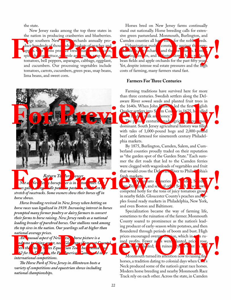
Return To HorsepowerNot all New Jersey horsepower is in automobiles. Our
horses gallop along bridle paths, in pastures, and down the stretch of racetracks. Some owners show their horses off in horse shows.
Horse breeding revived in New Jersey when betting on horse races was legalized in 1939. Increasing interest in horses prompted many former poultry or dairy farmers to convert their farms to horse raising. New Jersey ranks as a national leading breeder of purebred horses. Our stallions rank among the top sires in the nation. Our yearlings sell at higher than national average prices.
An unusual aspect of New Jersey’s horse picture is a handsome training center, near Gladstone (Somerset County), where the United States Equestrian Team has trained since 1962 for the Olympics, the PanAmerican Games, and other international competitions.
The Horse Park of New Jersey in Allentown hosts a variety of competitions and equestrian shows including national championships.
Horses bred on New Jersey farms continually stand out nationally. Horse breeding calls for exten-sive green pastureland. Monmouth, Burlington, and Camden counties all have room for the noble steeds.
Urbanization pushes constantly against the vege-table fields, the orchards, and the horse farms. Homes, shopping centers, and industry slowly have replaced bean fields and apple orchards for the past fifty years. Yet, despite intense real estate pressures and the high costs of farming, many farmers stand fast.
Farmers For Three Centuries
Farming traditions have survived here for more than three centuries. Swedish settlers along the Del-aware River sowed seeds and planted fruit trees in the 1640s. When John Fenwick led the first English Quaker settlers into Salem County in 1675, he called this “a land of milk and honey.”
The passing centuries made agriculture ever more dominant. South Jersey agricultural history was filled with tales of 1,000-pound hogs and 2,000-pound beef cattle fattened for nineteenth century Philadel-phia markets.
By 1875, Burlington, Camden, Salem, and Cum-berland counties proudly traded on their reputation as “the garden spot of the Garden State.” Each sum-mer the dirt roads that led to the Camden ferries were clogged with wagonloads of vegetables and fruit that would cross the Delaware River to Philadelphia’s fresh markets.
By 1900, tomato canneries in Camden, Swedes-boro, Bridgeton, and several other South Jersey towns competed hotly for the tons of juicy tomatoes grown in nearby fields. Gloucester County’s peaches and ap-ples found ready markets in Philadelphia, New York, and even Boston and Baltimore.
Specialization became the way of farming life, sometimes to the ruination of the farmer. Monmouth County soared to prominence as the nation’s lead-ing producer of early-season white potatoes, and then floundered through periods of boom and bust. High prices encouraged overproduction, which in turn ru-ined profits. Fewer acres were planted, prices rose, farmers overplanted; the ruinous cycles went on and on.
Monmouth turned its attention now to raising fine horses, a tradition dating to colonial days when Colt’s Neck produced some of the nation’s great race horses. Modern horse breeding and nearby Monmouth Race Track rely on each other. Across the state, in Camden
the state.New Jersey ranks among the top three states in
the nation in producing cranberries and blueberries. Large southern New Jersey orchards annually pro-duce hundreds of thousands of baskets of peaches and apples. Our farms produce fresh market sweet corn, spinach, head lettuce, escarole and endive, snap beans, tomatoes, bell peppers, asparagus, cabbage, eggplant, and cucumbers. Our processing vegetables include tomatoes, carrots, cucumbers, green peas, snap beans, lima beans, and sweet corn.
For Preview Only! For Preview Only! For Preview Only! For Preview Only!
23
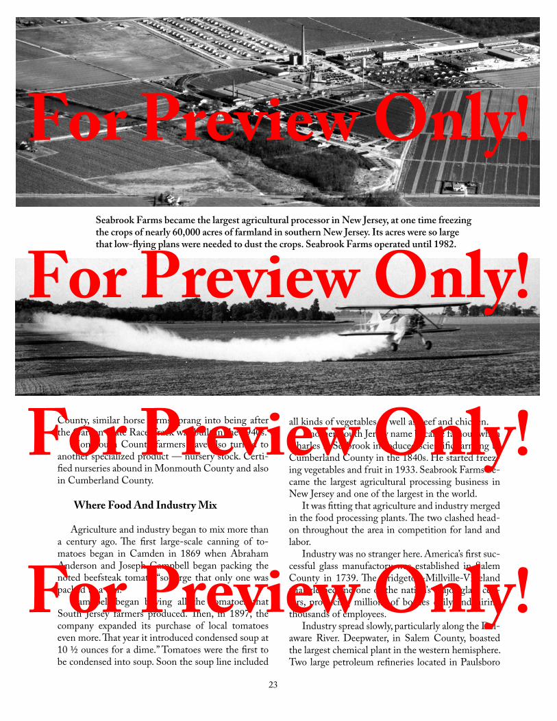
Seabrook Farms became the largest agricultural processor in New Jersey, at one time freezing the crops of nearly 60,000 acres of farmland in southern New Jersey. Its acres were so large that low-flying plans were needed to dust the crops. Seabrook Farms operated until 1982.
County, similar horse farms sprang into being after the Garden State Race Track was built in the 1940s.
Monmouth County farmers have also turned to another specialized product — nursery stock. Certi-fied nurseries abound in Monmouth County and also in Cumberland County.
Where Food And Industry Mix
Agriculture and industry began to mix more than a century ago. The first large-scale canning of to-matoes began in Camden in 1869 when Abraham Anderson and Joseph Campbell began packing the noted beefsteak tomato “so large that only one was packed to a can.”
Campbell began buying all the tomatoes that South Jersey farmers produced. Then, in 1897, the company expanded its purchase of local tomatoes even more. That year it introduced condensed soup at 10 ½ ounces for a dime.” Tomatoes were the first to be condensed into soup. Soon the soup line included
all kinds of vegetables as well as beef and chicken.Another South Jersey name became famous when
Charles F. Seabrook introduced scientific farming to Cumberland County in the 1840s. He started freez-ing vegetables and fruit in 1933. Seabrook Farms be-came the largest agricultural processing business in New Jersey and one of the largest in the world.
It was fitting that agriculture and industry merged in the food processing plants. The two clashed head-on throughout the area in competition for land and labor.
Industry was no stranger here. America’s first suc-cessful glass manufactory was established in Salem County in 1739. The Bridgeton-Millville-Vineland triangle became one of the nation’s major glass cen-ters, producing millions of bottles daily and hiring thousands of employees.
Industry spread slowly, particularly along the Del-aware River. Deepwater, in Salem County, boasted the largest chemical plant in the western hemisphere. Two large petroleum refineries located in Paulsboro
For Preview Only! For Preview Only! For Preview Only! For Preview Only!

24
and Westville. Camden became an electronics and industrial center. All the way north to Burlington and beyond teemed with industrial activity.
Farewell To Farmers?
Immediately after the New Jersey Turnpike sliced through the region in the 1950s, farmers had to pon-der whether it was better to continue plowing the soil or to sell their land to the highest bidders among real estate developers and factory builders. Many decided to reap the rich, quick money harvest. For a time, the state lost two or three farms a week to developers.
The orchards and asparagus fields of Gloucester County have been drastically reduced. The vegetable farms of Cumberland County are seriously threat-ened. Most of the huge chicken farms are but memo-ries. Homes now sprout where only asparagus shoots or pepper plants grew sixty years ago.
All is not lost, however. Vegetables and fruits are still harvested here in considerable quantities. Com-petition from other farm sections of the nation, high labor costs, and rising land taxes have cut steadily into farm profits.
The Garden State as a region of many small farms may well disappear within your lifetime. Some large operations will continue to farm the land, but per-sonal farming, as depicted in poetry and history, is a dying vocation. It takes a determined, overworked farm family to continue in the face of progress, mech-anization, and low income.
Sadly, when farmlands disappear, everyone loses. Farm prices rise. Water supplies are threatened as homes and factories increase their demands. Roads are crowded; air and water are polluted. The lush green farmland no longer exists to please the eye and enrich the spirit.
Enjoy the Garden Spot while it lasts.
Saving New Jersey’s FarmsPioneers are still present in New Jersey’s farmlands
— but now they work to keep farmers on the land rather than clearing pasturelands for new farms.
As the nation’s most densely populated state, New Jersey lost farms to developers at the rate of sixty-five acres every day for twenty-five years. When farms disappeared, everyone lost.
New Jersey recently has pioneered ways to keep satisfied farmers on the land. It is not easy. How can a farmer not be tempted when a developer offers him enough money for his land that he might never have to work again?
The state eased taxes for farmers in 1964, taxing acres for farm value rather than what the land might bring if an industry or home developer bought it. The State Department of Agriculture then proposed in 1973 that billions of dollars be spent to buy one million acres of farmland to keep it forever in agricultural use.
That was too rich for New Jersey taxpayers, but in 1977 a pilot program was set up in Burlington County to buy as many acres as possible for $5 million. Farmers who sold to the state could continue farming.
The Farmland Preservation Program continues — preserving some farms for eight years and others for life. The State Agriculture Development Committee (SADC) administers the program in voluntary cooperation with the counties, municipalities, and farm owners.
We know New Jersey voters want our farmers to stay. They continually allow their tax dollars to go toward keeping farms by voting yes for Farmland Preservation Bond Issues. The Preservation Program has sufficient funds to continue in the twenty-first century.
Nature’s uncertain rainfall forced New Jersey farmers to install extensive, and expensive, irrigation equipment in their fields.
250 ACRES For Preview Only! For Preview Only! For Preview Only! For Preview Only!

25
From the lookout tower in the big mansion at Batsto, the eyes wander in every direction — North, East, South, West, or to any of the countless points between.
Immediately below is the little village of Batsto. Beyond, reaching to the most distant horizon in all directions, only a vast area of treetops can be seen. A wisp of smoke might drift lazily upwards here or there. Nothing else indicates life in the unbroken greenness — not a house, not a road, not a person to be seen.
Out there, mysterious and challenging, is New Jersey’s most unusual region. This is the Pine Bar-rens, a famed forest that covers about one-fourth of the state.
Seldom has an area been so misnamed. The un-deserved reputation began more than three centuries ago. Settlers who could not grow their usual grains, hay, or vegetables in the sandy soil dismissed the area as “barren.” The sand made travel difficult, even on horseback. It became traditional to shun the region, even fear it.
Pine Barrens, indeed! Here is a land that supports incredible varieties of plants — little-known flowers such as turkey beard, pyxie moss, at least thirty-five different kinds of wild orchids, golden crest, sundews, insect-eating pitcher plants, and at least 400 other varieties of wild flowers. It is a land of cranberry bogs and blueberry plantations.
Here, too, are more than 150 kinds of birds, deer, muskrats, raccoons, several kinds of rare frogs, fly-ing squirrels, beavers, and several species of harmless snakes. The rarest creature is the Pine Barrens Tree Frog, found only here and in two other small, isolated colonies in North Carolina and Georgia.
Pitch Pine And Scrub Oak
The basic tree in the woodland is the pitch pine, some of which once grew as tall as eighty feet. Now, because of repeated forest fires — a persistent threat in every dry season — few pines are more than fifty feet tall. Most average thirty to forty feet. Intermin-gled are scrubby oak trees — scraggly and under-nourished — not the vigorous, proud oaks of song and legend.
The Pine Barrens
For Preview Only! For Preview Only! For Preview Only! For Preview Only!

26
Botanists from many parts of the world converge on the Pine Barrens to study and to catalogue the area’s abundant and often rare plants. One hope of botanists is to see the scarce diminutive Curly Grass Fern, found in the Pine Barrens and nowhere else in the United States!
The Pine Barrens is truly nature’s meeting ground. At Sim Place Bog, east of Penn State Forest in Burl-ington County, botanists seek out the very rare south-ern yellow orchid in early August. This is the north-ernmost home of the flower. Close by, within sight of the yellow orchid, one can find bearberry — a plant normally associated with the frozen Arctic tundra!
Witmer Stone, a noted South Jersey naturalist, surveyed Pine Barrens flora in 1910. He found that sixty plants usually associated with Canadian prov-inces reach their southern limit in the Pine Barrens, and 164 “Southern” (Virginia to Florida) species reach their northernmost limits here.
The Unchanging Woodland
Seventy-five years ago the Pine Barrens was mea-sured at about 1.3 million acres. Today it is nearly the same in size, despite the encroachment of roads, industry, and public buildings.
To visualize the magnitude, trace the perimeter on a map. Start at Freehold, go east to the Garden State Parkway, then south nearly eighty miles to Den-nisville in Cape May County. Swing west to Parvin State Park beyond Vineland, north past Berlin and
Wrightstown, and then back to Freehold.That encompasses about 1,900 square miles. Only
a few known town names appear within the perim-eter: Lakewood, Mays Landing, Millville, Vineland, Hammonton, and Egg Harbor City.
Elsewhere, place names reflect a simple past: Herman, Green Bank, Bulltown, and Pleasant Mills; Penny Pot, Milmay, Dorothy, and Apple Pie Hill; At-sion, Indian Mills, Red Lion, and Blue Anchor; Blue Bell, Double Trouble, and Roosevelt City; Retreat, Bamber, Prospertown, and Georgia.
The pine woodland seems to hide villages and crossroad towns. Small wonder, for an area as large as this can also take on military installations or state parks and scarcely seem touched.
Consider the Fort Dix Military Reservation in Pemberton Township. Begun during World War I, the reservation now covers 31,000 acres in Burling-ton County. Millions of Americans remember train-ing days at Fort Dix. Few ever saw the wild orchids. To them, “barrens” is a perfect name.
Fire: The Worst Enemy
The worst enemy of the Pine Barrens is fire that can destroy with a ferocious power. In the spring of 1963, an extended drought spread dread throughout the region. When fire came, powerful winds fanned the flames across nearly 190,000 dry acres. It was the largest wildfire in the region’s recorded history.
Spurred by a hot dry wind at its tail, a pineland wild
Slowly-moving coffee-colored streams meander through the midst of thick cedars in the Pine Barrens.
For Preview Only! For Preview Only! For Preview Only! For Preview Only!

27
fire devours everything before it. Such a fire can come up to a wide concrete highway, where it might reason-ably be expected to stop. In an angry roar of seeming frustration, it shoots red-hot sparks thousands of feet ahead, finds tinder-dry food, and blazes onward. Many fires burn the surface of macadam roads.
A pine woodland blaze is no place for a tourist. Even experienced firefighters know fear: fire destroys humans, too, with brutal suddenness. One blaze in 1936 killed five trained firefighters.
Nature eventually soothes the fiery wounds and spreads greenery on the charred floor. Indeed, forest fires even encourage certain types of orchids to flour-ish. Fire is an old, old terror in the Pine Barrens and might even have led Indians and original colonists to suspect the earth itself.
One remarkable fire-caused sight is the so-called “Plains,’’ nearly 15,000 stunted acres east of Brendan T. Byrne (formerly Lebanon) State Forest. Growth seldom exceeds twelve to fifteen feet in this lonely, for-saken place. Most trees are only four to six feet tall.
Long ago, it was believed that the “Plains’’ were jinxed by evil spirits or poor soils or both. Most scientists today blame fire. Repeated burnings in eight-to-twelve-year cycles apparently account for the shrunken, desolate area.
Water, Water, Everywhere
Water runs everywhere within the Pine Barrens. Streams are over-flowing, even in dry weather. Some, such as the Mullica, Tuckahoe, and Great Egg Har-bor rivers, Cedar Creek, and Toms River, are fine for canoeing.
Lush Pine Barrens growth is near the waterways
(that means practically anywhere). Here grow the dark green cedar forests, their roots cooled by the sphag-num moss of the surrounding swamps. Here cran-berry bogs dot the area. Here flow mahogany-colored waters as clean as any in New Jersey.
Underlying the sandy soil is a vast reservoir of al-most unlimited pure water, enough to supply at least a billion gallons daily. New Jersey officials recognized the value of that water in 1954 when they bought the 97,000-acre Wharton Tract in Burlington, Atlantic, and Camden counties.
The Pine Barrens remains a place for all seasons. Spring brings the stately wild laurel. Summer coaxes wild orchids into bloom and makes the blueberry plantations rich with color. Autumn finds the trees filled with chattering birds harvesting fall berries and seeds amid the fall foliage. Winter snow emphasizes the deep green leaves of holly trees mingling with the long-needled pines.
Pressures to “develop” the Pine Barrens frequently are heard. An effort to save much of the region was strengthened, on November 10, 1975, when Congress created the Pinelands National Reserve, the first such reserve in the nation. A year later, Governor Byrne appointed a New Jersey Pinelands Commission to supervise 1.1 million acres in the reserve. The reserve includes fifty-six municipalities and seven counties.
Many thousands of people pass the eastern fringe of the Pine Barrens each day in summer. Thousands more stream eastward from Camden or Trenton. They rush through the pine forests and see them as a barrier, not an attraction.
The automobiles whiz on, bound for the Jersey Shore, which is as much sought after as the Pine Bar-rens is shunned.
Machines stir up a cranberry bog in the Pine Barrens, forcing berries to float on the flooded area where they can easily be harvested. Cranberries continue to be an important crop in the Pine Barrens. Such mechanization is the chief way for southern New Jersey farmers to survive.
For Preview Only! For Preview Only! For Preview Only! For Preview Only!

28
Imagine buying 97,000 acres of pine woodland, two villages, parts of three rivers, several “ghost towns,” and enough underground water to supply all southern New Jersey.
The State of New Jersey did that in 1954 when it purchased the so-called Wharton Tract for $3 million. The tract spreads through three counties — Atlantic, Burlington, and Camden. Its area — 156 square miles — is much larger than Essex County’s total of 128 square miles.
Joseph Wharton, a Philadelphia industrialist and financier, began assembling acreage in 1876, hoping to raise such warm weather crops as sugar, cotton, and sugar beets. The experiments failed.
In 1891, Wharton expressed the hope that water on his land could be used for Philadelphia’s needs. The New Jersey legislature passed a
law prohibiting such a use.The land lay idle after Wharton’s death in 1909. Then, in 1954,
Alfred E. Driscoll, former governor, spearheaded a successful drive to buy the vast tract, primarily for the water potential.
Acquisition of the Wharton Tract more than doubled the state’s parkland total in 1954. Since then, millions of visitors have enjoyed the tract’s hunting, fishing, hiking, camping, canoeing, and other recreational activities.
Naturalists from many parts of the world visit to see the hundreds of flowers and shrubs growing beneath the towering pine trees. They must hike or ride Jeep-type vehicles over sandy trails, since only one major highway cuts through the preserve.
The most frequented spot within the Wharton Tract is Batsto, a village that has resisted forest fires and depressions for more than one hundred and fifty years. Batsto once produced iron and glass, and then became a “ghost village” until the state acquired the tract.
Threats to the Pine Barrens are constant, but in the Wharton Tract, the pines, the water, and the history are safe.
Water and pine trees are the two main components of the Pine Barrens, the last remaining large area of unspoiled woodland in the State of New Jersey.
Empire In The Pine Barrens
For Preview Only! For Preview Only! For Preview Only! For Preview Only!

29
Who really knows the Jersey Shore, that fabled 127 miles of oceanfront stretched between Sandy Hook and Cape May Point? Who knows this coast, in all its moods, all its seasons, all its variety?
Sandy Hook, long a secret defensive outpost but now a state park, is startlingly different from Wild-wood or Atlantic City. Cape May’s stately Victorian air is in sharp contrast with Asbury Park’s beachfront. No one place truly characterizes the Jersey Shore.
The Jersey Shore is actually several types of coast-line, beginning with Sandy Hook in the north. Now about seven miles long, the Hook is still being en-larged by sea-carried sand. It has quadrupled in size since it was first explored in 1665, and the old light-house, near the tip of the Hook when built in 1762, is now one-and-a-half miles inland.
Southward, from Long Branch to Manasquan In- let, mainland New Jersey meets the ocean directly. Despite Herculean efforts to restrain it, the Atlan-tic Ocean has pounded that coast back more than a thousand feet in recorded time — as much as thirty feet in a single savage thrust.
South of Point Pleasant, the oceanfront changes
again. Beginning at Bay Head, a long, thin peninsula juts southward, parallel to the mainland, for more than twenty miles. This peninsula includes state-owned Is-land Beach State Park as well as a string of resort towns.
From Barnegat Inlet, where old Barnegat Light-house stands as the best-known Jersey Shore symbol, every resort area south to Cape May is on an island. Long Beach Island advertises that it is “four miles at sea,” but few people realize that Atlantic City is also an island town.
The mainland touches the ocean again at Cape May City, although that resort occasionally calls itself an “island” because the Cape May Canal technically cuts it off from the mainland.
Waves chew constantly at the Cape May main-land. In 1804, Commodore Stephen Decatur, a Cape May vacationer, calculated the distance from Atlantic Hall to the edge of the beach to be 334 feet. Twen-ty-five years later, ocean tides splashed against the foundations of Atlantic Hall. The ocean had claimed 334 feet in twenty-five years.
A Golden Strand
For Preview Only! For Preview Only! For Preview Only! For Preview Only!

30
Gold Beside The Waves
Visitors have responded to the variety for more than two centuries. In 1766, when one Robert Par-sons sought to sell his 54-acre Cape May plantation, he praised “the Sea Shore, where a number resort for health and bathing in the water.” Long Branch at-tracted its first boarding house visitors in 1788.
Eighteenth century visitors walked, rode horse-back, or made the trip in wagons hauled through the Pine Barrens. Nineteenth century visitors ar-rived mainly by railroad car, and it was a railroad that brought Atlantic City into being in 1854. Today’s visitors jam the Garden State Parkway or Atlantic City Expressway on their way to their favorite patch-es of sand.
The Jersey Shore is big business. Summer cottages are always at a premium for summer rentals. The board-walks are crowded night and day. The beaches at the most popular resorts are packed with umbrellas, beach chairs, towels, and broiling bodies. Vacationers jet ski, parasail, surf the waves with their boards or bodies, wind surf, fish from the shore, board boats to fish at sea, swim, and relax on the beach.
About sixty separate communities line the ocean-front, but not more than a half dozen are genuine boardwalk towns, where the bright lights of night compete with the bright sun of day. Most of the re-sorts offer little more than sand and sunshine.
Many who travel to the shore never see the sand and surf; some never see the sun. Atlantic City attracts many to its dazzling casinos year-round. They come from near and far to gamble, dine in the fancy restau-rants, and enjoy the world-renown entertainment.
One person’s seaside pleasure is another’s bore-
dom. People who love Avalon or Stone Harbor in Cape May County wouldn’t go near Atlantic City. That doesn’t disturb Atlantic City supporters, most of whom have never even heard of Avalon or Stone Harbor. Small matter: there is room enough and va-riety enough for all.
Nature Ignores Mortgages
The Atlantic Ocean gives the Jersey Shore its beaches, its charm, its stimulation, and its value. The ocean also disputes minute by minute, year by year, those who claim to own the seacoast.
Developers ignore the ocean’s periodic, terrifying warnings. They slice away dunes and build castles on the uncertain sands. Buyers eagerly take out mort-gages to ensure themselves of beachfront cottages. Nature ignores mortgages, just as it ignores every at-tempt to keep the swirling waves in check. Nature expects cooperation, not opposition.
A comprehensive study of Jersey Shore erosion, made in 1923, showed that in a 100-year period the ocean had eroded away 5,521 acres. Some of the sand was carried off to build up a new 3,025 acres in other places, such as Sandy Hook. The remaining 2,496 acres — enough for nearly eleven million king-sized beach towels — simply vanished into the ocean.
Most of the damage occurs after the summer visi-tors have gone home. Severe storms usually slash the shore between late September and early November. One exception was a March 1962 storm that prob-ably was the most severe the oceanfront has ever ex-perienced.
The New Jersey Shore has only one real story: Ocean against sand. People are a passing phase. Usually
Fishermen relish the off-season tranquility of the Jersey Shore as much as summer beach-goers revel in its brilliant white sands and inviting surf.
For Preview Only! For Preview Only! For Preview Only! For Preview Only!

31
the ocean is relatively mild, but it can snarl and rip and destroy, especially when humans attempt to build counter to its will.
The ocean very seldom erupts during the summer. It calms down in June, July, August, and September, entertaining visitors with a majestic, controlled show under warm blue skies.
Barnegat Light, finished in 1857, stands 168 feet tall and is painted red and white (above). Long Beach Island vacationers affectionately call the light “Old Barney.”
Modern-day geological changes are evidenced in the beaches guarded by lighthouses at the northern and southern tip of the Jersey Shore. The ocean has given enough beach to Sandy Hook that its lighthouse (bottom, left) has appeared to move 1 ½ miles away from the ocean while Cape May Lighthouse (above) looks down at an eroding shoreline. Landings along the climb to the top of the lighthouse explain and depict the ongoing erosion stealing the beaches. The picture below, taken from the top of the lighthouse in November 2005, dramatically shows what erosion and storms can do. The bunker, made of reinforced concrete, with 6-foot roof and walls, was built on dry beach in 1942 — 900 feet from the ocean.
Then surf and sand become the Jersey Shore, a beacon for vacationers. The storms, the history, are of little concern to those who love this golden strand only in summertime.For Preview Only!
For Preview Only! For Preview Only! For Preview Only!

32
Island Beach: Sea Coast Bargain
Interpretive nature trails through Is-land Beach State Park offer access to the bay (left) and the ocean (right).
With a permit, you can drive a four-wheel drive vehicle onto the beach at the southern end of the park (left) and fish within view of Barnegat Light (right). Signs remind you to keep off the dunes.
Henry Phipps, a partner of Andrew Carnegie’s Pittsburgh steel ventures in the 1920s, could afford to indulge himself. If he wanted ten miles of beachfront along the Jersey Shore, he could buy it — as he did in 1926 when he acquired title to all of Island Beach.
Island Beach had lingered as a name, although the section had been just the lower end of a long peninsula since 1812. Until then, the area was really an island, since a channel through the peninsula allowed ships to sail into Toms River. A wild storm closed the channel in a single night.
Someday, Phipps thought, he might develop the property. The Depression killed that idea, Phipps died, and World War II came. By 1950, as the Jersey Shore was beginning a period of frenzied development, this strip of seacoast was much as it had been through all time.
New Jersey officials reacted quickly in 1952, after a real estate developer sought to buy Island Beach. The state paid $2.7 million for what the National Park Service termed “the last remaining significant stretch of natural beach and dune land in the Northeastern United States.” It was a precious bargain!
The ten-mile-long state-owned park preserves the natural state. There is a public swimming area and one mile of life-guarded beach in the northern part, near Seaside Park. Public access is also allowed for fishing, bird-observing, biking, and strolling the interpretive nature trails.
The natural area is an intriguing reminder of what the Jersey Shore was like when the first settlers came more than 375 years ago. Dunes rise high over the beachfront. Near Barnegat Bay on the west side Spanish oaks and holly trees thrive, and beach plums are a reminder of colonial days.
For Preview Only! For Preview Only! For Preview Only! For Preview Only!

348
AAbolition of slavery 63, 160, 161, 162, 165,
182Adams, John 80, 123African American 6, 63, 102, 115, 160, 161,
184, 225, 226, 265, 306, 311, 326, 340Agriculture 21-24, 164, 192, 212, 218, 224,
329Albania 52, 53, 54, 55Architecture 6, 200, 311Arnold, Benedict 109, 112Articles of Confederation 116, 120Asgill, Captain Charles 115Asian Americans 6Assembly 19, 55, 56, 63, 64, 65, 68, 79, 83, 84,
85, 88, 128, 168, 189, 241, 242, 247, 251, 275, 335, 345
Atlantic City 29, 30, 107, 117, 118, 133, 134, 180, 192, 194, 196, 210, 228, 232, 282, 283, 288, 290, 292, 294, 300, 315, 324
Atom bomb 284, 301, 302, 304, 312Automobiles 4, 5, 17, 22, 27, 186, 229, 230,
234, 236, 238, 248, 260, 261, 270, 272, 278, 279, 280, 295, 302, 304, 310, 314, 321, 322, 326, 328, 329, 336, 337, 339
BBarber, John Warner 141Barnegat Light 31, 32, 192Barracks 68, 75, 90, 266, 268, 300Bartholdi, Frederick 220Barton, Clara 157Baseball 117, 148, 149, 213, 232, 234, 255Batsto 25, 28, 107, 119, 334Battle of Monmouth 104Battle of Princeton 90, 100, 101Battle of Springfield 37, 90, 111Baxter, James M. 225, 226Belcher, Gov. Jonathan 67, 68Bell Telephone Laboratories 321Bicycling 234, 235Bill of Rights 144, 153, 307, 311Blacksmith 117, 213, 248, 267Blair, John I. 169, 208Blanchard, Jean Pierre 129Boudinot, Elias 114, 116Boyden, Seth 135, 138Breweries 42, 43, 240, 241, 292Bridgeton 82, 135, 142, 171British... See EnglishBrotherton 34Budget 124, 239, 308, 314, 330, 331, 336,
340, 342, 344Burlington 45, 60, 61, 62, 63, 66, 68, 75, 78,
79, 80, 83, 85, 113, 118, 119, 124, 125, 127, 128, 139, 154, 159, 160, 173, 176, 208, 238, 321
Byrne, Governor Brendan T. 27, 330, 331, 332, 334, 335, 340
CCahill, Governor William T. 331, 332Caldwell, Rev. James 110Camden 2, 18, 19, 124, 131, 132, 133, 134,
135, 139, 140, 148, 149, 150, 189, 191, 194, 196, 197, 200, 210, 211, 258, 266, 267, 270, 273, 275, 278, 279, 281, 284, 286, 295, 301, 302, 307, 309, 311, 313, 322, 324, 327, 328, 335, 343
Campbell, Joseph 23Camp Kilmer 257, 284, 299, 302, 313Carteret, Philip 54, 56, 63Carteret, Sir George 52, 55, 56, 58, 59, 60, 62Chestnut Neck 107Child labor 144, 146, 248Civil War 5, 49, 117, 139, 160, 164–185, 196,
224, 226, 256, 258, 288, 305, 320Clark, Abraham 86, 87Climate 5, 6, 40, 96, 217, 218, 258, 347Clinton, Gen. Henry 103, 104, 110, 113Coal 129, 130, 131, 132, 133, 145, 190, 200,
205, 207, 272, 327Codey, Acting Gov. Richard 336, 342, 344,
345, 346Cohansey Bridge 82College of New Jersey 63, 78, 80, 81, 86, 87,
101, 156, 164Collins, Isaac 113Colonization 5, 25, 36, 40, 52, 59, 60, 61, 62,
64, 74, 75, 77, 78, 79, 85, 87, 88, 112, 218, 295
Colt, Sam 136Commuters 6, 132, 196, 197, 230, 257, 268,
322, 328, 341, 342Concessions and Agreements of the
Proprietors 59Confederate army 168, 169, 171, 172, 175,
176, 177, 181, 184, 185Congress, First Continental 74, 80Congress, US 2, 27, 37, 52, 74, 79, 80, 83, 84,
85, 87, 88, 90, 95, 108, 109, 111, 112, 114, 115, 116, 118, 119, 120, 123, 127, 128, 137, 144, 150, 165, 185, 189, 247, 258, 265, 266, 297, 311, 328, 332, 334, 335, 336, 344, 346
Conservation 7, 12, 284, 289, 292, 321, 322, 327, 329, 332, 333, 334, 335, 340, 344, 345, 346, 347
Constitution 113, 116, 117, 120, 121, 137, 152, 153, 154, 168, 185, 188, 225, 250, 275, 284, 304, 330, 340, 341, 344
Constitution, NJ 74, 88, 113, 117, 152, 154, 185, 250, 284, 330, 340, 341, 344, 347
Continental Congress 74, 80, 83, 85, 87, 116Copperheads 173, 174, 175, 176Cornwallis, Gen. Charles 91, 92, 95, 100,
102, 113Corzine, Senator Jon 346, 347Covered bridge 316
Cranberry bogs 8, 25, 27, 282Crane, Stephen 80Cromwell, Oliver 53, 115Cudjo, Jack 115
DDairy 22Declaration of Independence 37, 59, 61, 74,
82, 87, 96, 114, 137, 138, 144, 167, 187, 188, 280, 328
DeHart, John 80Delaware & Raritan Canal 118, 130, 131,
155, 189, 282, 290Delaware Bay 39, 45, 46, 58, 128, 129, 260,
334, 347Delaware River 6, 12, 13, 14, 19, 22, 23, 37,
40, 44, 45, 46, 47, 49, 50, 59, 60, 61, 68, 75, 90, 92, 94, 98, 101, 102, 103, 108, 113, 121, 125, 127, 130, 133, 140, 148, 162, 169, 176, 200, 262, 278, 279, 284, 301, 302, 314, 319, 324, 327, 340
Delaware Water Gap 8, 9, 10, 11, 12, 316, 321
Democratic Party 152, 164, 165, 166, 167, 168, 171, 173, 177, 179, 184, 185, 239, 241, 245, 247, 251, 252, 253, 254, 275, 304, 305, 330, 331, 332, 335, 342, 346
Department of Environmental Protection 333, 335
Depression 6, 32, 118, 257, 283, 284, 285, 286, 288, 292, 294, 295, 331
DeVries, Captain David 42, 43DiFrancesco, Acting Gov. Donald T. 336,
341, 342, 345Dix, Dorothea 158, 159, 180Dodge, Mary Mapes 50Douglass, Mabel Smith 246Driscoll, Gov. Alfred E. 28, 305, 306, 307,
314Drumthwacket 336Duke of York 49, 50, 52, 53, 55, 59, 62DuPont 262, 270, 278, 295Dutch 6, 12, 18, 34, 35, 36, 37, 38, 39, 40, 41,
42, 43, 44, 45, 46, 47, 49, 50, 52, 55, 56, 63, 65, 76, 78, 90, 199, 228, 313
Dutch West India Company 40, 44
EEast Jersey 5, 83East New Jersey Proprietors 62Edison, Thomas Alva 19, 188, 234Education 19, 20, 57, 69, 72, 81, 98, 136, 144,
147, 155, 156, 157, 158, 160, 164, 187, 203, 204, 213, 214, 215, 216, 218, 225, 226, 228, 232, 242, 245, 248, 251, 256, 257, 260, 289, 301, 311, 312, 314, 318, 319, 332, 335, 340, 342, 344
Einstein, Albert 304, 313
Index

349
Elizabeth 15, 19, 20, 52, 64, 75, 78, 87, 110, 113, 114, 119, 125, 126, 128, 135, 141, 188, 211, 240, 243, 245, 246, 257, 261, 262, 278, 280, 282, 309, 318, 322, 324, 338
Elizabethtown 55, 56, 61, 62, 68, 88, 102, 116, 132, 142
Elmer, Jonathan 81, 83Elysian Fields 148, 149Emancipation Proclamation 117, 174, 176,
184England 65, 67, 68, 69, 73, 74, 75, 76, 77, 78,
79, 81, 82, 84, 85, 87, 88, 89English 6, 19, 22, 36, 37, 38, 40, 43, 47, 49,
50, 51, 52, 53, 54, 55, 56, 59, 60, 61, 63, 64, 65, 66, 68, 74, 75, 77, 79, 80, 81, 87, 91, 103, 107, 116, 118, 123, 132, 148, 176, 199, 222, 224, 238, 262, 272, 273, 294, 306
Environment... See ConservationEssex County Park Commission 20Explorers 33, 36, 244Explosions 262
FFactories 4, 8, 24, 117, 123, 133, 134, 135,
136, 138, 141, 145, 152, 198, 200, 202, 205, 217, 218, 221, 222, 225, 226, 245, 248, 249, 252, 257, 258, 262, 263, 270, 275, 286, 295, 304, 314, 336
Fagan, Mark M. 247, 248Farmland 4, 7, 8, 23, 24, 199, 299, 321, 340,
344, 347Farmland Preservation 7, 24Fenwick, John 22, 58, 59, 62Ferries 22, 66, 117, 125, 211, 280Fifteenth Amendment 185Finn’s Point 59, 176First New Jersey Brigade 173, 174, 175, 177Fisher, Henrick 79Fitch, John 127Florio, Gov. James 335, 336, 338, 339Football 187, 234, 296, 297Fort, John Franklin 249, 250Fort Christina 45, 46, 47, 48Fort Delaware 176Fort Dix Military Reservation 26, 290, 296,
299, 302, 338Fort Lee 2, 91, 92, 206Franklin, Benjamin 65, 74, 80, 83, 85, 123Franklin, William 74, 75, 76, 77, 78, 79, 80,
85Fraunces Tavern 105, 111French and Indian War 68, 77Frog War 191
GGarden State Parkway 17, 20, 26, 30, 314,
315, 317, 334, 342German 36, 65, 67, 97, 98, 148, 220, 234,
260, 262, 264, 265, 266, 268, 270, 292, 294, 295, 298
German American Bund (League) 294, 295Gibson Girls 233GI Bill 308, 311Glassworks 117, 119, 240, 241, 244Goodwin, Abigail 162Grant, Ulysses S. 97, 164, 180, 182, 188, 190,
198, 240Great Falls 18, 117, 123Great Swamp 8, 20, 333Greene, General Nathanael 102, 110Greene, Kitty 107Greenwich 59, 74, 81, 82, 83Greenwood Lake 129, 188, 194, 197Green Acres 333, 340
HHaddon, Elizabeth 64Hague, Frank 304, 306Half Moon 38, 39, 40, 50Hamilton, Alexander 101, 104, 120, 123Hancock, Cornelia 180Hancock, William and Sarah 73Hancock’s Bridge 45, 106, 180Hancock House 45Hart, John 86, 87Hasenclever, Baron Peter 65, 67Hays, Mary Ludwig ... See Pitcher, MollyHeard, Colonel Nathaniel 85, 101Hessians 90, 97, 98, 103, 110, 111, 171Hickory Men 166, 167Highlands 3, 13-16, 39, 65, 67, 95, 128, 276,
344, 345Highways 4, 7, 20, 124, 125, 126, 290, 314,
315, 319, 321, 322, 323, 324, 331High Point 6, 8, 9, 18, 210Holland, John Philip 19Hopkinson, Francis 86, 87Horses 22, 64, 66, 75, 101, 104, 108, 111, 112,
114, 119, 125, 126, 133, 141, 155, 157, 196, 208, 211, 228, 229, 231, 233, 234, 236, 238, 241, 250, 260, 261, 278, 279, 282, 304, 346
House, Nothnagle 45Howe, General William 90, 95, 102, 103Huddy, Captain Joshua 115Hudson, Henry 38, 244Hudson River 8, 38, 40, 42, 44, 48, 52, 54, 60,
66, 79, 91, 92, 107, 108, 110, 125, 127, 129, 132, 148, 198, 224, 243, 280
IImmigration 5, 6, 36, 48, 145, 187, 202, 207,
210, 217, 220, 221, 222, 223, 224, 225, 228, 249, 260, 265, 298
Industry 5, 18, 21, 22, 23, 24, 26, 62, 118, 123, 130, 135, 137, 186, 187, 188, 194, 199, 200, 216, 220, 222, 252, 276, 284, 314, 319, 321, 322, 324, 327, 328, 329, 347
Inflation 5, 109, 119Irish 6, 135, 136, 203, 225, 265, 266
Iron 15, 16, 28, 46, 53, 65, 67, 80, 129, 130, 131, 132, 133, 135, 138, 145, 155, 191, 198, 200, 247
Island Beach 8, 29, 32
JJersey City 15, 19, 41, 48, 66, 90, 108, 118,
124, 125, 127, 128, 129, 130, 132, 135, 142, 148, 152, 157, 162, 168, 169, 172, 183, 188, 189, 191, 192, 194, 196, 197, 202, 211, 212, 216, 217, 220, 221, 222, 223, 224, 227, 232, 239, 242, 243, 246, 247, 252, 261, 262, 263, 264, 267, 278, 280, 288, 290, 304, 306, 309, 312, 324, 325, 342, 343
Jersey Shore 4, 8, 20, 27, 29-32, 107, 128, 192, 194, 196, 224, 232, 236, 249, 256, 260, 261, 266, 272, 275, 276, 280, 284, 288, 285, 286, 288, 292, 298, 314, 317, 320, 347
Jockey Hollow 108, 111, 112John Bull 132, 221Juet, Robert 38, 39, 40
KKean, Gov. Thomas 257, 315, 328, 335, 336,
339, 344Kiefft, Governor William 42, 43Kilpatrick, General Judson 180, 181Kittatinny Mountains 6, 9-12Knights of Albion 47Knox, General Henry 107Knyphausen, General William von 110, 111Korea 5, 6, 347Kuwait 6, 337, 347
LLabor 145, 154, 187, 222, 223, 225, 232, 239,
241, 254, 265, 281, 308Lafayette, Marquis de 104, 109Lakey, Alice 246, 247Lake Hopatcong 14, 129, 130, 194, 196, 228,
232, 282, 292Landis, Charles K. 217Lawrence, James 128Lee, General Charles 95, 104, 106Lee, General Robert E. 177, 182Lee, Major Henry (“Light Horse Harry”)
108, 111Lenape 12, 33-35, 36, 39, 347Leutze, Emanuel 98, 104Lieutenent Governor 341, 347Livingston, Gov. William 80, 87, 88, 113,
118, 120, 121Lord Berkeley 52, 55, 56, 58, 59, 62, 52Lovell, Patience 65Loyalists 90, 96, 97, 106, 109, 118

350
MMaass, Clara Louise 260Macculloch, George P. 129Madison, James 120Marshall, James Wilson 137Marshlands 4, 20, 270, 278Maxwell, General William 103McGreevey, Gov. James 16, 336, 342, 344,
345, 346Mercer, Gen. Hugh 100Metropolitan Museum of Art 98, 127Mey, Cornelius 76Middlebrook 90, 106, 107, 109Millionaires 186, 187, 230, 231, 236, 239, 287Minisink Valley 12Minuit, Peter 38, 40, 44, 45Miss America 4, 14, 283, 283, 288, 292, 302Monmouth Race Track 22Moody, James 96Moravian 84Morris, Gov. Lewis 64, 65, 76Morris Canal 14, 117, 118, 129, 130, 131,
132, 282, 290Morro Castle 296Morse, Samuel F.B. 134Morven 114, 336Murphy, Gov. Franklin 247, 248, 249Mutiny 111, 112Mutual Benefit Life Insurance Company
308, 324
NNassau Hall 37, 78, 97, 101, 114Nast, Thomas 239, 240National Wildlife Refuge 8, 333Native Americans 33-35, 36, 39, 41, 43, 53,
63Newark 2, 4, 7, 15, 19, 20, 35, 49, 50, 52, 55,
56, 57, 59, 62, 63, 67, 68, 72, 73, 78, 84, 89, 91, 92, 94, 97, 115, 119, 121, 123, 124, 126, 129, 130, 131, 132, 135, 136, 142, 144, 149, 151, 152, 154, 157, 158, 160, 161, 164, 165, 166, 167, 168, 169, 173, 175, 176, 178, 180, 188, 191, 194, 196, 197, 200, 202, 203, 204, 206, 210, 211, 212, 214, 215, 225, 226, 227, 228, 229, 234, 236, 240, 241, 246, 247, 248, 249, 252, 253, 254, 257, 258, 259, 260, 261, 265, 266, 267, 268, 270, 272, 274, 275, 278, 279, 280, 282, 286, 287, 288, 290, 294, 295, 298, 301, 302, 305, 307, 308, 309, 310, 312, 313, 315, 316, 318, 319, 322, 324, 326, 327, 338, 339, 341, 342
Newark (Liberty International) Airport 20, 258, 278, 280, 305, 318, 326, 341, 342
Newspapers 4, 6, 12, 64, 67, 74, 82, 113, 151, 169, 170, 178, 185, 213, 232, 235, 239, 247, 253, 254, 255, 262, 285, 290, 308, 330, 331
New Amsterdam 18, 37, 38, 40, 41, 42, 43, 44, 45, 46, 47, 48, 49, 50, 51, 54
New Brunswick 44, 68, 74, 75, 76, 78, 80, 87, 90, 92, 95, 97, 98, 101, 102, 124, 125, 126, 129, 130, 132, 135, 142, 158, 162, 166, 183, 194, 200, 204, 211, 221, 234, 240, 258, 260, 261, 272, 275, 278, 299, 311, 313, 314, 346
New Jersey Brigade 115, 170, 173, 174, 175, 177, 182
New Jersey Performing Arts Center 339New Jersey Turnpike 17, 20, 24, 125, 126,
314, 317, 319, 321New Sweden 3, 37, 38, 44, 45, 46, 47, 48, 49,
50New York City 5, 7, 18, 108, 128, 129, 130,
131, 133, 168, 169, 171, 173, 178, 189, 191, 204, 205, 206, 212, 240, 276, 279, 280, 286, 301, 307, 326
New York Ship Corporation 301, 302, 322Nicolls, Gov. Richard 50, 52Nugent, James 253, 254
OOlden, Gov. Robert 165, 167, 169, 171, 178Old Barracks 68Old Mine Road 12
PPaine, Thomas 92, 94Palisades 2, 6, 8, 39, 40, 91, 92, 206, 232, 243,
244Parliament 64, 74, 77, 78, 79, 80Paterson, William 120, 121Paulus Hook 66, 90, 108, 124, 125, 128Pea Patch Island 176Penn, William 59, 61Persian Gulf War 257, 328, 337Perth Amboy 61, 62, 63, 67, 68, 74, 75, 76,
77, 83, 84, 85, 102, 119, 125, 200, 221, 276, 280
Philadelphia 4, 5, 6, 7, 14, 17, 18, 22, 28, 32, 37, 47, 51, 52, 61, 62, 64, 65, 66, 74, 75, 76, 78, 80, 83, 84, 85, 87, 88, 90, 93, 95, 96, 98, 102, 103, 106, 108, 109, 111, 112, 113, 114, 116, 117, 118, 119, 120, 121, 122, 123, 124, 125, 127, 128, 130, 132, 133, 139, 140, 142, 143, 148, 149, 150, 154, 158, 159, 160, 169, 179, 180, 188, 189, 190, 191, 192, 194, 197, 200, 202, 204, 207, 210, 212, 214, 220, 222, 228, 238, 256, 279, 281, 282, 284, 288, 314, 320, 322, 324, 326, 332, 334, 336, 343
Picatinny Arsenal 262, 297, 337Piedmont 18, 20Pinelands...See Pine BarrensPine Barrens 3, 6, 8, 18, 21, 25-28, 30, 34, 44,
61, 66, 119, 133, 160, 217, 244, 266, 282, 299, 334, 335
Pitcher, Molly 104, 105, 106
Pollution 5, 7, 207, 210, 227, 239, 329, 330, 331, 332, 347
Population 6, 42, 63, 65, 84, 120, 130, 133, 135, 136, 141, 160, 187, 190, 191, 194, 200, 210, 212, 221, 225, 226, 228, 234, 249, 270, 274, 275, 297, 311, 328, 332, 345, 347
Port Camden 327, 338Port Newark 20, 272, 301, 302, 305, 324,
326, 338Port of New York (and New Jersey)
Authority 279, 280, 321, 324, 333Princeton 2, 19, 37, 78, 79, 81, 87, 89, 90, 92,
97, 98, 100, 101, 112, 113, 114, 115, 124, 129, 137, 139, 156, 158, 164, 167, 168, 169, 170, 182, 187, 221, 234, 236, 238, 250, 262, 265, 286, 304, 306, 311, 313, 335, 336, 337, 338, 346
Princeton University 78, 100, 221, 238, 250, 304
Privateers 107Progressive Era 232, 253Prohibition 258, 274, 275, 276, 278, 283, 292Proprietary House 83Proprietors 13, 55, 56, 59, 61, 62, 63, 66, 67,
68, 74, 83Provincial Congress 74, 80, 83, 84, 85, 87Prudential Insurance Co. 210, 215, 216, 302,
308, 324, 339Pure Food bill 246Puritans 36, 49, 53, 54, 55, 57, 81
QQuakers 36, 37, 52, 54, 56, 58, 59, 60, 61, 63,
65, 69, 88, 90, 162Queens College 78Queen Anne 63, 64
RRailroads 4, 19, 20, 30, 117, 118, 127, 129,
131, 132, 133, 134, 135, 138, 140, 141, 149, 160, 161, 162, 169, 175, 186, 187, 188, 189, 190, 191, 194, 196, 197, 198, 199, 200, 205, 206, 208, 212, 215, 217, 219, 222, 228, 230, 239, 245, 247, 279, 299, 308, 310, 311, 324, 325, 327
Rall, Col. Johann 97, 98Recreation 9, 14, 268, 289, 340Redcoats 91, 97, 101Republican Party 118, 165, 166, 167, 168,
169, 173, 176, 184, 185, 239, 240, 242, 245, 247, 248, 249, 250, 251, 252, 275, 283, 284, 287, 304, 305, 331, 332, 335, 336, 342, 344, 345, 346
Reservoirs 12, 15, 27, 67, 228, 329, 330, 331, 333, 335
Revolution 3, 4, 5, 6, 15, 19, 36, 56, 65, 66, 76, 78, 88, 89, 90-115, 118, 137, 139, 141, 171, 203, 308

351
Rockingham 114Rocky Hill 114, 115, 124Roebling, John 135, 208Rutgers University 2, 19, 78, 305, 312, 335,
339
SSandy Hook 5, 8, 29, 30, 38, 39, 43, 54, 104,
107, 115, 128, 130, 172Satellites 5, 319, 320, 347Schwarzkopf, Gen. H. Norman 337, 338Scots 6, 61, 234Seabrook Farms 23Sherman, Gen. William T. 180Skiing 14Slavery 36, 37, 62, 63, 65, 88, 115, 144, 151,
156, 160, 161, 162, 164, 167, 174, 176, 188, 212, 240
Society for Establishing Useful Manufactures 124
Sons of Liberty 77, 78, 79Stagecoach 124, 125Stamp Act 37, 74, 77, 79Stanger brothers 119State Assembly 128, 247, 335State Seal 119Statue of Liberty 210, 220, 221, 239, 262Stem cell research 344, 346Stevens, John 19, 126, 129, 131Still, James 160Still, William 160, 162Stockton, Annis Boudinot 114Stockton, Commodore Robert Field 137Stockton, Richard 79, 86, 87, 114Stone, Lucy 242, 253Stout, Penelope 43Stuyvesant, Peter 46, 47, 48, 49, 50, 51Suburbia 197, 198, 311, 312, 314, 316, 319,
321, 324, 329Suffrage 232, 245, 247, 253, 254, 255, 257,
258, 275Sugar Act 77Sunfish Pond 11, 12Sunrise Mountain 11, 13Swedes 6, 36, 38, 45, 46, 47, 49, 50, 51, 59,
65, 73Swedesboro 22, 51
TTaxes 5, 24, 55, 56, 74, 77, 78, 79, 80, 141,
156, 197, 207, 217, 230, 242, 247, 309, 319, 326, 327, 330, 331, 332, 336, 340, 342, 344, 346, 347
Tea Party 74, 80, 81, 82Telegraph 128, 134, 138, 144, 169, 175, 182,
187, 202, 204, 270Television 6, 7, 307, 308, 335, 337, 339, 342,
343, 344, 346Thirteenth Amendment 182, 184Thorough and efficient education 257, 304,
332, 340Tock’s Island 12Tories... See LoyalistsTreat, Robert 49, 73Treaty of Paris 37, 90Trenton 2, 19, 27, 35, 37, 60, 61, 68, 73, 76,
84, 89, 90, 97, 98, 108, 112, 113, 115, 118, 119, 120, 121, 124, 125, 126, 127, 129, 130, 131, 132, 135, 137, 141, 144, 152, 155, 156, 158, 159, 162, 164, 166, 167, 168, 171, 176, 179, 189, 190, 191, 200, 208, 214, 216, 217, 218, 223, 227, 240, 241, 242, 243, 247, 248, 250, 251, 252, 258, 267, 278, 282, 287, 290, 304, 309, 312, 319, 322, 329, 330, 335, 336
Tubman, Harriet 162Turnpikes 125, 126
UUnderground Railroad 144, 160, 162Union Army 175, 177, 179, 180, 182Urbanization 3, 5, 6, 7, 15, 18, 22, 135, 137,
187, 194, 210, 211, 212, 213, 226, 228, 229, 287, 304, 308, 327, 332, 340, 347
USS New Jersey 328, 343
VVail, Alfred 134Verrazano, Giovanni da 33Victorian Age 207, 236Vietnam 5, 6, 257, 308, 328, 330, 337, 343,
347
WWall, Colonel James W. 164, 173, 176War in Iraq 328, 347War of 1812 117, 118, 126, 128, 136Washington, George 6, 16, 18, 37, 86, 91,
92, 94, 95, 97, 98, 100, 101, 102, 103, 104, 106, 107, 108, 109, 111, 112, 113, 114, 115, 116, 117, 118, 120, 121, 123, 124, 128, 129, 134, 135, 136, 150, 166, 167, 170, 171, 172, 173, 178, 182, 208, 241, 246, 252, 254, 261, 280, 281, 282, 283, 287, 296, 314, 321, 322, 330, 332, 336, 343
Watchung Mountains 102Weslager, C.A. 45West Jersey 3, 5, 52, 322West New Jersey Proprietors 62Wetlands 335Wharton Tract 27, 28Whitall, Ann Cooper 103Whitman, Gov. Christine Todd 336, 338,
339, 340, 341, 342Whitman, Walt 200Wilson, Woodrow 221, 238, 250, 251, 252,
255, 341Wistar, Casper 65Witherspoon, Rev. John 86, 87Women’s Clubs 187, 232, 242, 245, 246, 255Woodlands 7, 8, 20, 206Woolman, John 88World War I 16, 26, 187, 206, 225, 231, 232,
236, 255, 257, 258-274, 278, 295, 299, 301, 318, 322, 337
World War II 6, 16, 32, 257, 284, 292-304, 305, 322, 324, 328, 330, 331, 343, 347
YYorktown 37, 90, 112, 113, 114, 115, 171, 174

352

Publishing Co., Inc.PO Box 1399
Andover, NJ 07821www.aftonpublishing.com