New Hampshire State Soil - Soils 4 Teachers
5
Marlow New Hampshire State Soil Soil Science Society of America Photo Soil Monolith: Chip Clark/Smithsonian Institution Introduction Many states have a designated state bird, flower, fish, tree, rock, etc. And, many states also have a state soil – one that has significance or is important to the state. The “Marlow” is the official state soil of New Hampshire. Let’s explore how the Marlow is important to New Hampshire. History Marlow was established as a soil series in 1939 in the town of Marlow in Cheshire Coun- ty, NH. Although not officially adopted as the State Soil by the Legislature, Marlow was chosen by a committee of New Hampshire Soil Scientists several years ago, and is recog- nized as the State Soil nationally by the USDA Natural Resources Conservation Service. What is Marlow Soil? The Marlow series consists of well drained soils that formed in loamy glacial till, derived mainly from granite, gneiss and schist. They are often found on smooth rounded hills (drumlins) and mountain side slopes in glaciated uplands. They are moderately deep to a dense substratum and very deep to bedrock. Every soil can be separated into three separate size fractions called sand, silt, and clay, which makes up the soil texture. They are present in all soils in different proportions and say a lot about the char- acter of the soil. The surface, subsoil, and substratum textures of Marlow soil are sandy loams. Directly below the surface (A horizon) is an ashy gray or white layer of leached sandy material (E horizon). Be- low the E is the subsoil (B horizon) that is dark with accumulated organic materials and reddish from accumulated iron. The Substratum (C horizon) consists of dense till (hardpan) that was deposited and then compacted by the glacier. (Figure 1) Fig. 1. Marlow profile, with a white leached layer and dark reddish brown subsoil. Credit: USDA-NRCS
Transcript of New Hampshire State Soil - Soils 4 Teachers

MarlowNew Hampshire State Soil
Soil Science Society of America
Photo Soil Monolith: Chip Clark/Smithsonian Institution
IntroductionMany states have a designated state bird, flower, fish, tree, rock, etc. And, many states also have a state soil – one that has significance or is important to the state. The “Marlow” is the official state soil of New Hampshire. Let’s explore how the Marlow is important to New Hampshire.
HistoryMarlow was established as a soil series in 1939 in the town of Marlow in Cheshire Coun-ty, NH. Although not officially adopted as the State Soil by the Legislature, Marlow was chosen by a committee of New Hampshire Soil Scientists several years ago, and is recog-nized as the State Soil nationally by the USDA Natural Resources Conservation Service.
What is Marlow Soil? The Marlow series consists of well drained soils that formed in loamy glacial till, derived mainly from granite, gneiss and schist. They are often found on smooth rounded hills (drumlins) and mountain side slopes in glaciated uplands. They are moderately deep to a dense substratum and very deep to bedrock.
Every soil can be separated into three separate size fractions called sand, silt, and clay, which makes up the soil texture. They are present in all soils in different proportions and say a lot about the char-acter of the soil. The surface, subsoil, and substratum textures of Marlow soil are sandy loams. Directly below the surface (A horizon) is an ashy gray or white layer of leached sandy material (E horizon). Be-low the E is the subsoil (B horizon) that is dark with accumulated organic materials and reddish from accumulated iron. The Substratum (C horizon) consists of dense till (hardpan) that was deposited and then compacted by the glacier. (Figure 1)
Fig. 1. Marlow profile, with a white leached layer and dark reddish brown subsoil. Credit: USDA-NRCS

2
Where to dig MarlowYes, you can dig a soil. It is called a soil pit and it shows you the soil profile. But the Marlow soil is hard to dig once you get down into the substratum. This layer is called a hardpan for good rea-son. The different horizontal layers of the soil are called soil ho-rizons. Typically soil profiles have three main horizons: surface, subsoil and substratum. Marlow covers over 300,000 acres of land in eight counties of New Hampshire (Figure 2). This does not mean that other types of soil cannot be found there but that the Marlow is one of the most common. In all, there are a total of about 190 named soils (series) in New Hampshire.
ImportanceWhat makes Marlow soil so important? The broad, gently slop-ing hillsides and summits of loamy drumlins (a typical Marlow location) provide some of the most productive soils for farmers and foresters in the harsh granitic landscapes of New Hampshire. From rock-lined rolling fields to the steep forested uplands of the White Mountains, Marlow soils underlie much of the pictur-esque backdrop of rural New Hampshire (Figure 3). Many of the State’s current farms are located on this same land that the early settlers cleared of trees and picked of stones. Marlow soils are also economically important soils for timber products, where the mature forest typically consists of spruce and fir and hardwoods, such as sugar maple and beech.
UsesSoils can be used for many purposes, including agriculture (grow-ing crops, pasture, and woodland); engineering (roads and build-ings); ecology (wildlife habitat, wetlands), recreation (ball fields, playground, camp areas) and water filtration and purification.
Marlow soils are typically used for timber production of hard-woods, pasture and some agriculture. Excellent yields of silage corn, grasses, and legumes can be obtained with the proper use of lime and fertilizers. Nearly level areas of Marlow soils that are free of stones are considered prime farmland.
Fig. 2. Distribution of Marlow Soil in New Hampshire. Credit: Smithsonian Institution’s Forces of Change.
Fig. 3. Marlow soils (foreground) are found on uplands, where the glacier left smooth rounded hills called “drumlins”. Credit: Karen Dudley
LimitationsWhen a soil cannot be used for one or more of the described functions, it is referred to as a limitation. Soil experts, called Soil Scientists, studied Marlow soil and identified that it does have limitations. Steeply sloping areas and long slope length are a moderate to severe limitation for agriculture and forestry (Figure 4). A perched water table and dense substratum is a severe limitation for on-site sewage disposal.
Fig. 4. Marlow soil formed in sandy loam glacial till, often with many stones and boulders. Credit: NH Soils Staff
3
ManagementThe relatively short growing season and cool summers restrict the choice of crops and the long slopes require contour farm-ing and cover crops to limit the amount of erosion. Agricultural crops will benefit from the use of lime and fertilizer on these strongly acid soils. In areas where roadbeds or basements are cut below the hardpan, drainage is necessary to remove the wa-ter during wet times of the year. Septic systems will required raised absorption fields.
Marlow FormationBefore there was soil there were rocks and in between, CLORPT. Without CLORPT, there will be no soil. So, what is CLORPT? It is the five major factors that are responsible for forming a soil like the Marlow series. It stands for Climate, Organisms, Relief, Parent material and Time. CLORPT is responsible for the devel-opment of soil profiles and chemical properties that differentiate soils. So, the characteristics of Marlow soil (and all other soils) are determined by the influence of CLORPT. Weathering takes place when environmental processes such as rainfall, freezing and thawing act on rocks causing them to dissolve or fracture and break into pieces. CLORPT then acts on the rock pieces, till, outwash, eolian, alluvium, marine, lakebed sediments and vegetative materials to form soils.
Climate – Temperature and precipitation influence the rate at which parent materials weather and dead plants and animals decompose. They affect the chemical, physical and biological relationships in the soil. The Marlow soil typically developed under forest cover in cool, moist environments, averaging about 46 inches of rainfall per year. These influences result in the decomposition of organic matter and the leaching of soluble bases.Organisms – This refers to plants and animal life. In the soil, plant roots spread, animals burrow in, and bacteria break down plant and animal tissue. These and other soil organisms speed up the breakdown of large soil particles into smaller ones. Plants and animals also influence the formation and dif-
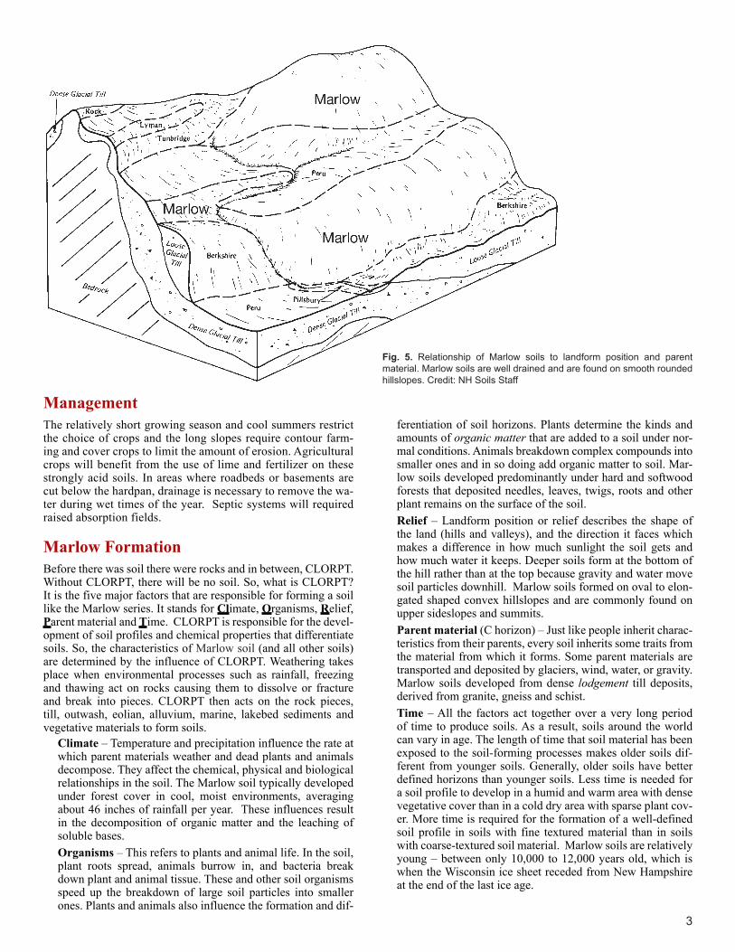
ferentiation of soil horizons. Plants determine the kinds and amounts of organic matter that are added to a soil under nor-mal conditions. Animals breakdown complex compounds into smaller ones and in so doing add organic matter to soil. Mar-low soils developed predominantly under hard and softwood forests that deposited needles, leaves, twigs, roots and other plant remains on the surface of the soil. Relief – Landform position or relief describes the shape of the land (hills and valleys), and the direction it faces which makes a difference in how much sunlight the soil gets and how much water it keeps. Deeper soils form at the bottom of the hill rather than at the top because gravity and water move soil particles downhill. Marlow soils formed on oval to elon-gated shaped convex hillslopes and are commonly found on upper sideslopes and summits. Parent material (C horizon) – Just like people inherit charac-teristics from their parents, every soil inherits some traits from the material from which it forms. Some parent materials are transported and deposited by glaciers, wind, water, or gravity. Marlow soils developed from dense lodgement till deposits, derived from granite, gneiss and schist. Time – All the factors act together over a very long period of time to produce soils. As a result, soils around the world can vary in age. The length of time that soil material has been exposed to the soil-forming processes makes older soils dif-ferent from younger soils. Generally, older soils have better defined horizons than younger soils. Less time is needed for a soil profile to develop in a humid and warm area with dense vegetative cover than in a cold dry area with sparse plant cov-er. More time is required for the formation of a well-defined soil profile in soils with fine textured material than in soils with coarse-textured soil material. Marlow soils are relatively young – between only 10,000 to 12,000 years old, which is when the Wisconsin ice sheet receded from New Hampshire at the end of the last ice age.
Fig. 5. Relationship of Marlow soils to landform position and parent material. Marlow soils are well drained and are found on smooth rounded hillslopes. Credit: NH Soils Staff

The State of New Hampshire can be subdivided into two major ecoregions (Figure 6) in order to highlight important differences in the environmental factors (CLORPT) affecting soil develop-ment and plant species. Southern New Hampshire is warmer than the rest of the state and is part of the Northeastern Coastal Zone Ecoregion. The area was glaciated, which caused it to have an irregular topographic relief, but it is not as hilly and mountain-ous as the Northeastern Highlands to the west and north. The soils tend to be rocky and nutrient poor. Natural vegetation is dominated by hardwood and mixed forests.
Fig. 6. Marlow soils are in the Northeastern Highlands Ecoregion.Credit: Jamin Johanson
Ecoregions, Soils and Land Use in New Hampshire Marlow soils are found in the Northeast Highlands Ecoregion in northern and western New Hampshire. The ecoregion con-sists of rocky, nutrient poor, frigid soils that formed in glacial deposits on hilly to mountainous terrane, typically blanketed by northern hardwood and spruce-fir forests. The ecoregion dis-plays many remnants of glaciation, including rocky soils, hard-pan, glacial lakes, and numerous wetlands. The White Moun-tains are the prominent mountain range in the New Hampshire portion of the ecoregion.
4

GlossaryClay: A soil particle that is less than 0.002 mm in diameter. Clay par-ticles are so fine they have more surface area for reaction. They hold a lot of nutrients and water in the soil. A clay soil is a soil that has more than 40% clay, less than 45% sand and less than 40% silt. Ecoregion: Represents areas with similar biotic and abiotic charac-teristics which determine the resource potential and likely responses to natural and man-made disturbances. Characteristics such as cli-mate, topography, geology, soils, and natural vegetation define an ecoregion. They determine the type of land cover that can exist and influence the range of land use practices that are possible.Hardpan: Dense lodgement till that is often an impermeable layer.Horizon: see Soil horizonsLeaching: The removal of soluble material from soil or other material by percolating water.Lodgement till: Glacial material that is deposited between the moving glacier and bedrock. The material is then compressed and compacted.Organic matter: Material derived from the decay of plants and ani-mals. Always contains compounds of carbon and hydrogen.Perched water table: An area in soil that stays saturated that’s not connected to the aquifer. It’s identifiable by all the same characteris-tics as a regular water table – signs of reduction and depleted irons and colors in the soil. The difference is that there will be a layer (or many layers) of soil underneath it that do not show signs of saturation. It’s caused by a layer of soil that restricts water flow.Sand: A soil particle between 0.05 and 2.0 mm in diameter. Sand is also used to describe soil texture according to the soil textural tri-angle, for example, loamy sand.Sandy Loam: Soil material that contains 7 to 20% clay, more than 52% sand, and the percentage of silt plus twice the percentage of clay is 30 or more; or less than 7% clay, less than 50% silt, and more than 43% sand.Silt: A soil particle between 0.002 and 0.05 mm diameter. It is also used to describe a soil textural class.Soil Horizon: A layer of soil with properties that differ from the layers above or below it.Soil Profile: The sequence of natural layers, or horizons, in a soil. It extends from the surface downward to unconsolidated material. Most soils have three major horizons, called the surface horizon, the sub-soil, and the substratum.Soil Scientist: A soil scientist studies the upper few meters of the Earth’s crust in terms of its physical and chemical properties; distri-bution, genesis and morphology; and biological components. A soil scientist needs a strong background in the physical and biological sciences and mathematics.Soil Texture: The relative proportion of sand, slit, and clay particles that make up a soil. Sand particles are the largest and clay particles the smallest. Learn more about soil texture at www.soils4teachers.org/physical-propertiesSubsoil: (B horizon) The soil horizon rich in minerals that eluviated, or leached down, from the horizons above it. Not present in all soils. Substratum: (C horizon) The soil horizon which is relatively unaf-fected by weathering or soil development.Topography: The shape of the land surface. (Relief: refers to differ-ences in elevation of different points in a region.)Topsoil: (A horizon) The horizon that formed at the land surface. Mostly weathered minerals from parent material with a little organic matter added.Water table: The top layer of ground water where the soil is filled with standing water. It can move up or down during different seasons.
Additional ResourcesSoil! Get the Inside Scoop. David Lindbo and others. Soil Science Society of America, Madison, WI.Know Soil, Know Life. David L. Lindbo, Deb A. Kozlowski, and Clay Rob-inson, editors. Soil Science Society of America, Madison, WI.
Web Resources Soils for Teachers—www.soils4teachers.orgSoils for Kids—http://www.soils4kids.org/Have Questions? Ask a Soil Scientist—https://www.soils.org/askSoil Science Society of America—https://www.soils.org/
New Hampshire Links:NH NRCS webpage: https://www.nrcs.usda.gov/wps/portal/nrcs/site/nh/home/NH Association of Conservation Districts: http://www.nhacd.net/NH Department of Agriculture: http://www.agriculture.nh.gov/Society of Soil Scientists of New Hampshire: https://sssnne.org/New Hampshire Association of Natural Resource Scientists: http://nhanrs.org/
ReferencesSoil Survey Staff, Natural Resources Conservation Service, United States Department of Agriculture. Web Soil Survey. Available online at https://websoilsurvey.sc.egov.usda.gov/. Accessed [January/30/2017].Soils Staff, United States Department of Agriculture, Natural Resources Conservation Service, 2011. New Hampshire State-Wide Numerical Soils Legend.United States Department of Agriculture, Natural Resources Conser-vation Service, 1999. Soil Survey of Grafton County, NH.
Authors: Peter Whitcomb, NRCS Soil Scientist Karen Dudley, NRCS Soil Scientist
5585 Guilford RoadMadison WI 53711-5801Tel. 608-273-8080 • Fax 608-273-2021www.soils.org • [email protected]
This state soil booklet was developed under the auspices of the Soil Science Society of America’s K-12 Committee—their dedication to developing outreach materials for the K-12 audience makes this material possible.