NEW APPROACHES TOWARDS OPEN SPACESduac.org/site_content/attachments/Preet Vihar.pdf · Anand Vihar...
31
CITY LEVEL PROJECTS NEW APPROACHES TOWARDS OPEN SPACES Preet Vihar Community Centre
Transcript of NEW APPROACHES TOWARDS OPEN SPACESduac.org/site_content/attachments/Preet Vihar.pdf · Anand Vihar...

CITY LEVEL PROJECTS
NEW APPROACHES TOWARDS OPEN SPACESPreet Vihar Community Centre

Delhi Urban Art Commission
The Delhi Urban Art Commission was set up by an Act of Parliament in 1973
to “advise the Government of India in the matter of preserving, developing
and maintaining the aesthetic quality of urban and environmental design within
Delhi and to provide advice and guidance to any local body in respect of any
project of building operations or engineering operations or any development
proposal which affects or is like to affect the skyline or the aesthetic quality of
the surroundings or any public amenity provided therein”.
(An ISO 9001 : 2008 Certified Organisation)

(An ISO 9001 : 2008 Certified Organisation)
DELHI URBAN ART COMMISSION with gratitude duly acknowledges the valuable contributions
of the following in making this report:
Organisations / Others
Ministry of Urban Development
Delhi Development Authority
Government of National Capital Territory of Delhi
North Delhi Municipal Corporation
East Delhi Municipal Corporation
South Delhi Municipal Corporation
New Delhi Municipal Council
Geospatial Delhi Limited
Delhi Metro Rail Corporation
Delhi Urban Shelter Improvement Board
BSES Rajdhani Power Limited
BSES Yamuna Power Limited
RWA’s and Area Councillors
Google Earth
Senior ConsultantAmit Ghosal
ConsultantsKomal GuptaMitali kediaAbhishek GauravPrashant ChaturvediAnil Kumar (3D Visualizer)
Delhi Urban Art Commission
Prof. Dr. P.S.N. Rao Chairman
Sonali Bhagwati Member (Upto 5 October, 2017)Samir Mathur MemberSonali Rastogi MemberDurga Shanker Mishra Member & Addl. Secretary, Ministry of Housing and Urban Affairs
(Upto 10 August, 2017) Manoj Kumar Member & Addl. Secretary, Ministry of Housing and Urban Affairs
(From 11 August, 2017)
Vinod Kumar Secretary
DUAC StaffRajeev Kumar Gaur, Raghvendra Singh, Indu Rawat, Amit Mukherji, Uma Bhati, Manju Anjali, Siddharth Sagar,Nihal Chand

*DISCLAIMER*
This report is for academic purposes only and has been prepared on the basis
of information gathered from various sources, in cases without any independent
verification. The report can be adopted and utilized by any Government Authority/
Local Body in the Country and is provided free of cost. The report is not meant to
derive any kind of gain, monetary or otherwise.
Though all efforts have been made to ensure the accuracy of the information in this
report, the same should not be construed as a statement of law or used for any legal
purposes. Delhi Urban Art Commission (DUAC) accepts no responsibility in relation
to the accuracy, completeness, usefulness or otherwise, of the information contained
in the publication. Stakeholders are advised to verify/check any information with
the relevant Government Department(s) and/or other source(s), and to obtain any
appropriate advice before acting on the information provided in the report.
While adequate measures have been taken to acknowledge the source of the
information used in the report, the nature of the process and the diverse sources
from which information is collected makes it difficult for the Commission to ascertain
whether each piece of information/data impinges upon any third party intellectual
property rights. DUAC shall consequently not be responsible for any inadvertent and
/ or bonafide omission of acknowledgement of source of information.
In no event will the DUAC be liable for any expense, loss or damage including,
without limitation, indirect or consequential loss or damage, or any expense, loss or
damage whatsoever arising out of any person/ stakeholder using or implementing or
relying on any information in this report.
(An ISO 9001 : 2008 Certified Organisation)
Preface
The city of Delhi, capital of this vast land of diversities, is a city laden with layers of history,
a place where civilizations have lived, prospered and perished over centuries. The modern
city today, built over and around a rich tapestry of heritage, presents an opportunity
at every turn, to allow for co-existence of the past, present and the future. In order to
understand this multidimensional urban spectrum and attempt to plan the future, various
city level studies have been initiated by the DUAC. I hope that these studies will help
the planners of modern day Delhi to carefully articulate urban space, structure, form and
environment and sensitively address future requirements.
I convey my thanks to all the Consultants and Members of the Commission who have
tirelessly worked on this research project to bring out this document. I also take this
opportunity to place on record my sincere appreciation of the efforts of Secretary and
other staff of DUAC for providing the necessary administrative support to make this
happen.
I fondly hope that the authorities of the local, state and national government take these
studies seriously and implement, in right earnest, the suggestions given herein.
September, 2017 Prof. Dr. P.S.N. Rao Chairman, DUAC
Sd/-

Contents1 Context 8 1.1 Zone Plan ‘E’ 8
1.2 Location and Connectivity 9
1.3 Movement and Development around the Site 10
1.4 Site 11
1.5 Issues on Ground 12 1.5.1 Circulation 12
1.5.2 Visual Environment 13
1.5.3 Utilities 12
1.5.4 Public Open Spaces 13
1.6 Existing Visualization of Site 14
2 Design Formulation 16 2.1 Structure Plan 17
2.2 Proposed Master Plan 20
2.2.1 3D View of the Site 20
2.2.2 Site Sections 22
3 Proposals 24 3.1 Proposal 1: Circulation Network 24
3.1.1 Visualization of Circulation Network 26
3.1.2 Redesign of Vikas Marg Road and Facilities around the Community Centre 28
3.1.3 Redesign of Acharya Nag Raj Marg and Facilities around the Community Centre 32
3.2 Proposal 2 – Reorganizing Informal Spaces 36
3.3 Proposal 3 – Public Open Spaces 38
3.3.1 Structure Plan 38
3.3.2 Design Alternatives 39
3.3.3 Existing Open Space Network 40
3.3.4 Proposed Layout for Public Open Spaces 42
3.3.5 Visualization of Public Open Spaces 44
3.4 Proposal 4 – Visual Environment 46
3.4.1 Architectural Controls 48
3.5 Proposal 5 – Utilities 52
Summary
Community Centres have played a significant role in the life of many local communities and networks, as they
are not only limited to recreational activities, but act as magnets attracting citizens from different sections of
society. The study is directed towards policy making, with solutions that emphasize the formulation of guidelines
and regulations for these areas. The study is dovetailed with the prevailing Master Plan and Zonal Plan of Delhi.
Major issues witnessed by the residents around the community centre of Ward No 228 are related to :
(a) Transport, (b) Parking, (c) Urban Design, (d) Public Open Spaces and (e) Solid Waste Management.
Each of these issues have been analysed in order to draft recommendations and proposals. The aim of the
study focuses on ‘New Approach Towards Open Spaces’ by showcasing the case example of Preet Vihar
Community Centre and its precincts. The approach to this study has been evolved by understanding the lack
of maintenance in the area, coupled with degradation of the Community Centre in the present scenario. The
change has been proposed by minimal yet meaningful interventions by selective and specific development of
the area with a series of design solutions along with identifying policy making and controls. The scheme thus
requires development based on urban design principles involving the community, built form and space use.
The proposals also identify the stakeholders involved along with the affected community for the regeneration
of the precinct.
Major points which were considered while making policy guidelines include: integration of circulation pattern
namely pedestrian and vehicular and open space network, which helps in the facilitation of various activities
on the site. It is important while designing, to keep in mind uninterrupted pedestrian circulation which affects
people at various stages. Informal street vendors cater to people from different strata of society and thus are
structured within the design proposals.
It is observed that the issues faced by residents and the associations in the community centres and district
centres around Delhi are generic in nature, thus the findings and recommendations can be applied to similar
proposals. Hence the study can be envisaged as a prototype for development of similar spaces in Delhi.

CO
NTE
XT
CO
NTE
XT
8 9CITY LEVEL ProjECT CITY LEVEL ProjECT
1.1 Zone Plan ‘E’
Introduction The Master Plan 2001 evolved the concept of facility centres and service centres to group two or more facilities available in the area and provide the required social infrastructure to service these facilities. The NCTD has been divided into 15 planning Zones (divisions) designated as ‘A’ to ‘P’ (except Zone ‘I’) in the Master Plan 2021. Planning Zone E comprises an area of 8797 ha (approx.). This zone is surrounded on three sides by Uttar Pradesh and on the fourth by the Yamuna River. For the purpose of “Operations and Maintenance” MCD has divided it into two Zones i.e. Shahdara North and Shahdara South.
1.2 Location and ConnectivityLocated in the east of Delhi, the zone is well connected by Metro. It is the last ward falling within the boundary of Delhi according to the Master Plan 2021. The ward is bounded by Noida Link Road in the west and the Delhi boundary on the north, south and east. A railway line passes close to the site. Anand Vihar Inter State Bus Terminal (ISBT) is the nearest bus depot at a distance of approximately 4 km.
Zonal Development Plan of Zone E(Source: Zonal Development Plan (Division) E , East Delhi (2010), www.dda.org/planning)
Key Map showing the site(Source: Open Street Maps (2016), https://www.openstreetmap.org/search?query=DELHI#map=10/28.5978/77.2236 )
Location of Zone E in Delhi
ZONE-O
Place Distance from Preet Vihar
New Delhi Railway Station 10 km
ITO 6 km
CP 10 km
Anand Vihar 4 km
SITE
Special Characteristics of the ZoneZone ‘E’ is a large area with old structures and buildings that are in a poor structural condition. It has inadequate infrastructure services and lacks community facilities. Historically East Delhi developed as a series of colonies that were dependent for trade on existing centres in Delhi. Areas closer to GT Road developed into an industrial area.
Significant Features of the Zone are:i) Laxmi Nagar District Centreii) Sanjay Lakeiii) CBSE Buildingiv) Yamuna Sports Complex
v) Mandoli Jailvi) All India Radio Training Centrevii) Mayur Vihar District Centreviii) Gazipur Landfill Site
xi) Anand Vihar Railway Terminalx) DMRC, Shastri Rail Yard
Preet Vihar Ward No 228(Source: Base Image- Google Earth )
Site
Laxmi Nagar District Centre
Vikas
Marg
Swami D
ayanand Marg
Defence Enclave
Brijpuri Extension
Joshi Colony
Railway Colony
Laxmi Nagar District Centre Sanjay Lake, Trilokpuri Ghazipur Landfill Site(Souce : http://www.dailymail.co.uk/indiahome/indianews/article-3024964/Ghazipur-plant-fuels-toxic-alarm-5-million-tonnes-garbage.html)
(Souce : https://www.panoramio.com/m/photo/49783997) (Souce : http://www.dnaindia.com/locality/bn/east-delhi/will-migratory-birds-come-sanjay-lake-next-year-31031)

CO
NTE
XT
CO
NTE
XT
10 11CITY LEVEL ProjECT CITY LEVEL ProjECT
1.3 Movement and Development around the Site
Movement Pattern Vikas Marg is the major road passing through the Preet Vihar Community Centre. The connectivity in the east is via Karkardooma Flyover which links the zone to Noida. The site is well connected by Metro. On the West, ITO junction connects the site via Laxmi Nagar District Centre. A network of roads and MRTS provides good connectivity to access other destinations.
Yamuna Bank Station to the left and the intersection of Vikas Marg and Link Road to the right
Foot over-bridges connecting Laxmi Nagar Station to different sides of the road intersection
Nirman Vihar Station with the Lakshmi Nagar Commercial Complex and the adjoining V3S Mall
1.4 Site
Preet Vihar Community Centre seen from Vikas Marg
Preet Vihar Metro Station Gate No. 2 Preet Vihar Community Centre seen from Acharya Nag Raj Marg
Growing Commercial Area around the Metro Station
The Preet Vihar Station and the adjoining commercial complex
Road
LegendMetro Station Gardens Built-Up Site
Built-Up Gardens Playgrounds Scrubs Metro Station
LegendRoad Railway Line
Mahavir Swami Park
CBSE
Metro Hospital
Government School
Metro Station, Preet Vihar
Karkardooma Flyover
Railway
Line
Vikas M
arg
Parwana Road
Master Plan Road
DDA Park
Laxmi Nagar District Centre
Krishna Jayanti Park
Metro Station, Nirman Vihar
Metro Station, Preet Vihar
TO ITO
TO K
ARKARDOOMA
VIKAS M
ARG
(Blue
Line
Metr
o)
ACHARYA NAG RAJ M
ARG
ACHARYA N
AG RAJ M
ARG
SITEArea: 13.25 ha.
PARWAN
A ROAD
1
2
3
4
5
Vikas Marg in Preet Vihar is the most congested stretch within the precinct experiencing a high traffic volume. Of late, the corridor and neighbourhood edges have been further compromised by surface parking by shop owners. New vendors encroaching on to the road have also constrained the traffic flow.
1 2 3
5
4
(Source: Kapur Varun Shiv (2010), https://www.flickr.com/photos/varunshiv/4978741215/in/album-72157624931160176/
(Source: Kapur Varun Shiv (2010), https://www.flickr.com/photos/varunshiv/4978741215/in/album-72157624931160176/
(Source: Kapur Varun Shiv (2010), https://www.flickr.com/photos/varunshiv/4978741215/in/album-72157624931160176/
(Source: Kapur Varun Shiv (2010), https://www.flickr.com/photos/varunshiv/4978741215/in/album-72157624931160176/
(Source: Kapur Varun Shiv (2010), https://www.flickr.com/photos/varunshiv/4978741215/in/album-72157624931160176/

CO
NTE
XT
CO
NTE
XT
12 13CITY LEVEL ProjECT CITY LEVEL ProjECT
1.5 Issues on the Ground
1.5.1 Circulation• The pedestrian walkway near Vikas Marg and Acharya Nag Raj Road is
underutilized due to encroachment by vendors.• Cars parked by the residents of Preet Vihar on the pavement obstruct the
walkway.• Residents have encroached upon the pedestrian pathway by building ramps
on their respective properties, which obstruct pedestrian movement.• No organized parking system particularly in markets. Road space is used to
accommodate parking and this creates chaos.• Service roads tend to create congestion at the main Vikas Marg junction.• Lack of pick-up and drop-off points.
1.5.3 Utilities• Open dumping of the waste creates unhygienic
conditions and encroachments on pedestrian pathways.• Waste is generally dumped in following areas of the
Community Centre: – Parking area – Corners and along edges – Street vending areas• There is no scientific method adopted for waste
handling at present.• Transportation of waste in open trucks during peak
hours creates both nuisance and traffic congestion.• There are no spatial standard norms adopted by
concerned local bodies for the placement of waste receptacles.
Encroachment by vendors on to the footpath around the Community Centre
Encroachment of vendors and rickshaw pullers on to the road connecting the Community Centre to the Metro station
1.5.4 Public Open Spaces• There is a lack of congregation space
in the Community Centre.• Due to large amount of waste
(construction, demolition and food waste from eating hubs), green spaces have become unfit for use.
1.5.2 Visual Environment• All corridors inside the Community
Centre have been painted with shop names creating an unpleasant view.
• Advertising boards are hung all over the buildings which makes identification of facilities confusing and chaotic.
• Huge unused hoarding panels obstruct the building view from Vikas Marg.• Shops on the ground floor have encroached both temporarily or
permanently upon corridors, blocking access. Similarly, office extentions on the upper floors have encroached upon balconies. Air conditioners projecting from the wall façade degrade the visual appeal.
Unused green spaces because of construction waste Low maintenance of green spaces
On-street parking reduces the carriageway of the road
Unused Subway
On Street Parking
Slip Road
109
Non-segregated and mixing of wet and dry waste reduces the reusable value of the recyclable waste
Neglected corners in the circulation area
87
42 3
1
Advertising boards on the façade of the building spoil the elevation
Hoarding on the main Vikas Marg blocks the view of the Commercial Centre
6
Pillars with painted shop signs along the corridor
5

CO
NTE
XT
CO
NTE
XT
14 15CITY LEVEL ProjECT CITY LEVEL ProjECT
1.6 Existing Visualization of Site
16 17CITY LEVEL ProjECT CITY LEVEL ProjECT
DEs
igN
FO
rmu
laTi
ON
DEs
igN
FO
rmu
laTi
ON
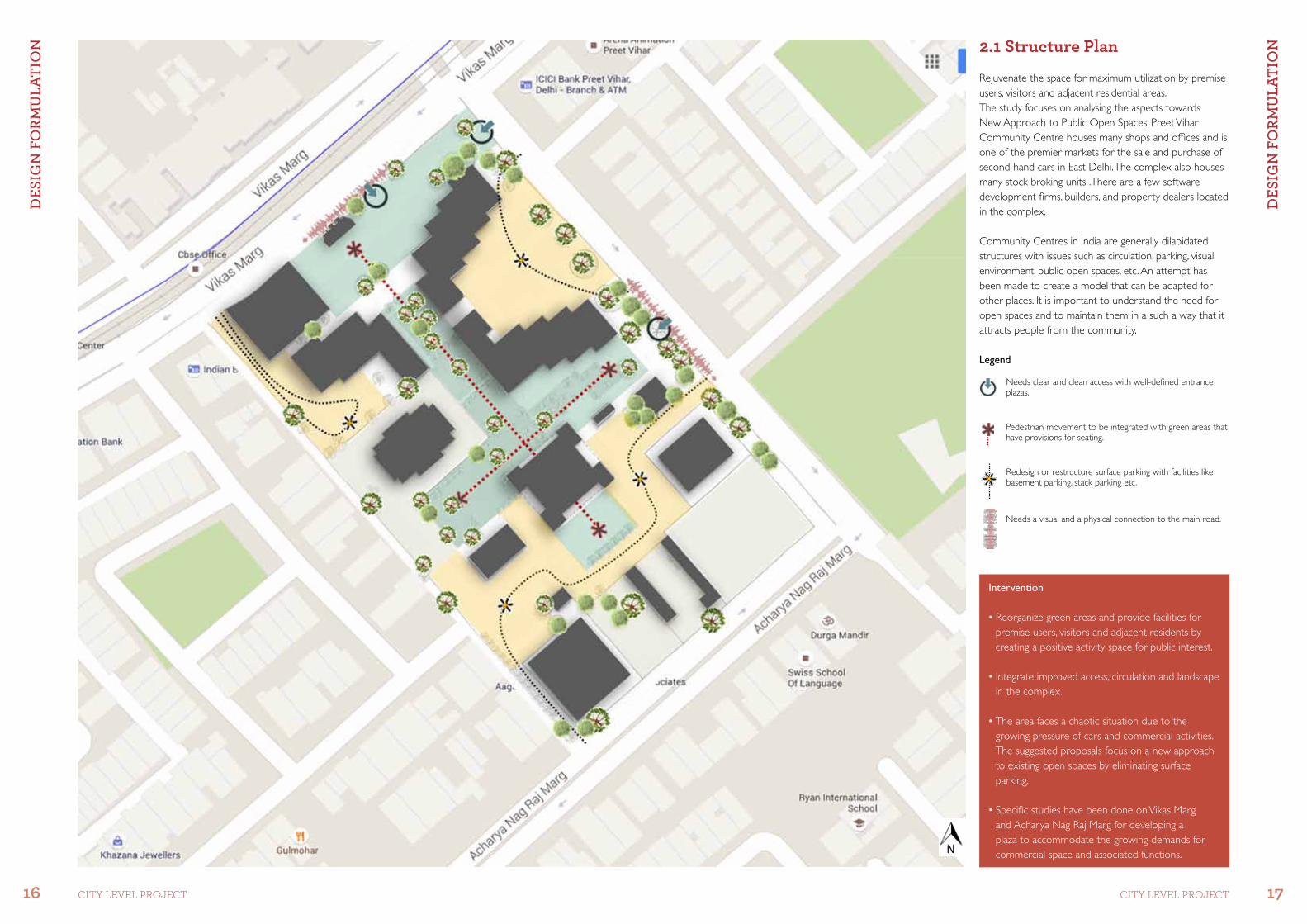
Intervention
• Reorganize green areas and provide facilities for premise users, visitors and adjacent residents by creating a positive activity space for public interest.
• Integrate improved access, circulation and landscape in the complex.
• The area faces a chaotic situation due to the growing pressure of cars and commercial activities. The suggested proposals focus on a new approach to existing open spaces by eliminating surface parking.
• Specific studies have been done on Vikas Marg and Acharya Nag Raj Marg for developing a plaza to accommodate the growing demands for commercial space and associated functions.
Rejuvenate the space for maximum utilization by premise users, visitors and adjacent residential areas.The study focuses on analysing the aspects towards New Approach to Public Open Spaces. Preet Vihar Community Centre houses many shops and offices and is one of the premier markets for the sale and purchase of second-hand cars in East Delhi. The complex also houses many stock broking units .There are a few software development firms, builders, and property dealers located in the complex.
Community Centres in India are generally dilapidated structures with issues such as circulation, parking, visual environment, public open spaces, etc. An attempt has been made to create a model that can be adapted for other places. It is important to understand the need for open spaces and to maintain them in a such a way that it attracts people from the community.
2.1 Structure Plan
Legend
Needs clear and clean access with well-defined entrance plazas.
Pedestrian movement to be integrated with green areas that have provisions for seating.
Redesign or restructure surface parking with facilities like basement parking, stack parking etc.
Needs a visual and a physical connection to the main road.

18 19CITY LEVEL ProjECT CITY LEVEL ProjECT
DEs
igN
FO
rmu
laTi
ON
DEs
igN
FO
rmu
laTi
ON 2.2 Proposed Master Plan
Building
Green
Road
Pavement
Context
Metro Pillars
Subway
Plot Area
Staircase
Legend
Stack parking has been provided in the complex, under the open area in order to maximise parking space. A buffer of 4.5 m has been kept from the building to minimise the effect on the building foundation.
Area of Basement: 12165 sq mCirculation Area: 7182 sq mNo. of cars: 450Area occupied by parking: 3837 sq m
To solve the parking problem, basement parking has been proposed at the Preet Vihar Community Centre. The issues in the existing precinct are:• Traffic congestion• Lack of a parking facility• Encroachment of parking space by car traders• No designated parking area• Haphazard signage and hoardings• Underutilized open spaces• Encroachment by hawkers in open spaces
Project 5: Reorganize green areas and provide facilities for premise users, visitors and adjacent residents by creating positive active spaces
Project 3: Ramps provided on Acharya Nag Raj Marg for basement entry to avoid vehicular parking on the main road
Project 1: Tabletop junction provided for better traffic flow
Project 4: Slip roads are eliminated in order to avoid congestion at the junction
Project 2: Development of a landscaped plaza on Vikas Marg. Integration of street furniture and kiosks
Project 6: Proper allocation of spaces for vendors inside the community centre in order to make the open spaces more interactive and decongest the streets
Project 7: Imposing Urban Design Guidelines for façade control
Project 8: Working on issues pertaining to Solid Waste Management in the area

20 21CITY LEVEL ProjECT CITY LEVEL ProjECT
DEs
igN
FO
rmu
laTi
ON
DEs
igN
FO
rmu
laTi
ON 2.2.1 3D View of the Site

22 23CITY LEVEL ProjECT CITY LEVEL ProjECT
DEs
igN
FO
rmu
laTi
ON
DEs
igN
FO
rmu
laTi
ON
Approach To CBSE
Green Area Near Community Centre
Community Centre
Central Green Spine Basement Acharya Nag Raj Marg Road
Basement Under Green
Staircase Core
Green
Section BB’
2.2.2 Site Sections
Key Plan
Section AA’
Other Buildings at the Site
CBSE Building
Public Plaza BasementWay to Basement
Aditya ArcadeCommunity Hall
Entrance Plaza
Pedestrian Entrance
Max Hospital
Police Station
Pedestrian Entrance
A
B
B’
A’

24 25CITY LEVEL ProjECT CITY LEVEL ProjECT
PrO
POsa
ls
PrO
POsa
ls
Proposed:• Pedestrian 31.15% (9865 sq m)• Vehicular 9% (2886 sq m)
Existing:• Pedestrian 11.35% (3596 sq m) CBSE 4.9% (1554 sq m)• Vehicular 9.3% (2933 sq m) CBSE 3.5% (1130 sq m)
3.1 Circulation Network
On-Site Circulation
Circulation Outside the Site
Circulation pattern inside CBSE complex
Towards Karkardooma
Legend
Issues• Pedestrian: Lacks defined pedestrian entrances Lacks clear passages or walkways Lacks plazas, sitting spaces or pause points
• Vehicular: Parking beyond its threshold leaves no circulation for the movement of cars within the premises Lacks drop-off zones
• Traffic from Vikas Marg towards the Preet Vihar Community Centre will take the ramp down after taking a U-turn from Acharya Nag Raj Marg to the basement parking of the Community Centre.
• No access has been provided for the basement from Vikas Marg because of heavy volume of vehicular traffic as well as pedestrian movement.
• The gap in the median of the Acharya Nag Raj Marg has been shifted away from the proposed ramp so that the throughfare for non-stop traffic is unobstructed.
• Vehicles coming out of the basement parking of the Community Centre will take the at grade U-turn to go towards the Metro Hospital.
• Ramps for the basement provided in the Community Centre are placed away from the road so that cars coming out can get some breathing space by not hitting the road directly.
• To maintain the continuity of the footpath, a tabletop crossing has been provided at the entry points to the Community Centre.

26 27CITY LEVEL ProjECT CITY LEVEL ProjECT
PrO
POsa
ls
PrO
POsa
ls 3.1.1 Visualization of Circulation network
View of the drop-off zone from Vikas Marg
View of Vikas Marg towards Karkardooma
View of pedestrian and vehicular entry points on Acharya Nag Raj Marg
Subway for pedestrian access
Tactile paving for the visually impaired
Drop-off zone to access the Community Centre from Vikas Marg
Tabletop crossing for continuous pedestrian movement
Staircase core opening on Vikas Marg
Access to service road from Vikas Marg
Access to basement car park from Acharya Nag Raj Marg
Staircase core opening near the vending zone
Reorganised street vendors and open spaces within the community centre
Pedestrian entrance from the main road leading to the structured activity zone
Dustbins provided to manage solid waste within the site
Public utilities (toilet facility) for passersby (pedestrian and vehicular)
Rickshaw stand near the plaza for better connectivity with public transport
Public plaza with facilities like kiosks, shaded seating spaces and pedestrian connectivity to Community Centre
Circulation outside the Site
On-Site Circulation
Circulation Pattern inside CBSE
Towards Karkardooma
Legend
Pedestrian Connectivity to the Site
Existing Circulation Network
Circulation outside the Site
On-Site Circulation
Circulation Pattern inside CBSE
Towards Karkardooma
Legend
Pedestrian Connectivity to the Site
Proposed Circulation Network

28 29CITY LEVEL ProjECT CITY LEVEL ProjECT
PrO
POsa
ls
PrO
POsa
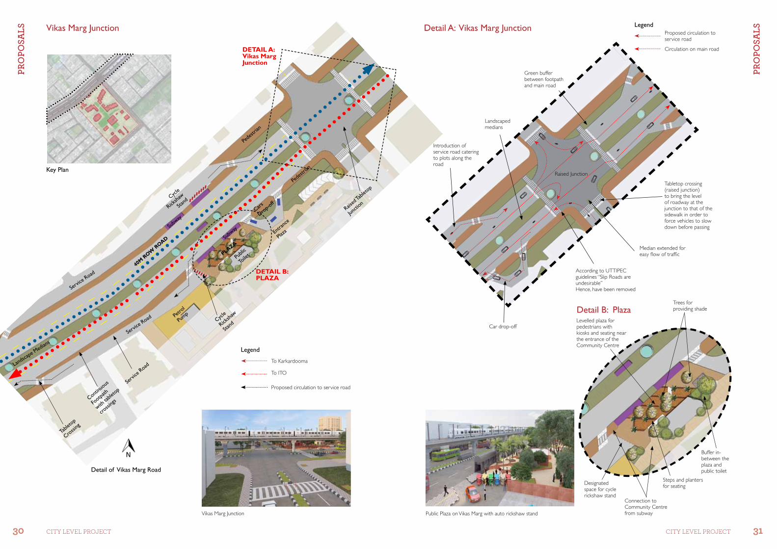
ls 3.1.2 Redesign of Vikas Marg and Facilities around the Community Centre
Present SituationThe entrance road from Karkardooma to ITO is 40 m wide. Because of the Metro pillars, the existing carriageway on the road is reduced. The edges of the road are flanked by commercial activities such as, street vendors, shops, etc. It is also the spillover area for Preet Vihar Community Centre and Laxmi Nagar District Centre.
The existing road being 40 m in width, lacks a pavement, dedicated hawking spaces, etc. making it extremely difficult to traverse. The road carries heavy pedestrian and vehicular traffic throughout the day.
The issues observed at the Vikas Marg junction are:
• As the junction is not planned efficiently for both vehicular and pedestrian movement, it creates regular traffic jams.
• There is no proper lane division at the junction.
• Pedestrian movement is affected due to encroachment by vendors and rickshaw pullers on the edges of the junction.
Redesign of the Road• Designated space for hawkers so as to reduce travel delays and reduce congestion on the road.
• Parking space for rickshaw pullers.
• Separate and uninterrupted pedestrian pathway provided with tabletop crossings.
• Green belt under the Metro line.
• A shaded public plaza for recreational activities by integrating kiosks and street furniture with provisions like a public convenience block, well-lit ambiance, seamless onward connectivity from the subway and road to the site and pick-up drop-off spaces with Inter Para Transit (PT) vehicle stands.
• Connectivity from pedestrian subways.
• Slip roads have been eliminated from Vikas Marg and approach to the properties is provided from service road. The entrance of which is 50 m away from the main junction to avoid congestion caused by the slip road.
Proposed Plan for Vikas Marg
Typical Existing Section of Vikas Marg
Typical Proposed Section for Vikas Marg
30 31CITY LEVEL ProjECT CITY LEVEL ProjECT
PrO
POsa
ls
PrO
POsa
ls
Detail of Vikas Marg Road
Vikas Marg Junction
Cars
Drop-o
ff
Entra
nce
Plaza
Cycle
Ricksha
w
Stand
Servi
ce Road
40M ROW
ROAD
Publi
c
Toile
tPLAZA
Subw
ay
Subw
ay
Pede
strian
Pede
strian
Table
top
Crossi
ng
Raised
Table
top
Juncti
on
Landsca
pe Median
s
Cycle
Ricksha
w
Stand
Continu
ous
Footpa
th
with ta
bletop
crossi
ngs
Servic
e Road
Petro
l
Pump
Servic
e Road
Vikas Marg Junction
DETAIL B:PLAZA
DETAIL A:Vikas Marg Junction
Levelled plaza for pedestrians with kiosks and seating near the entrance of the Community Centre
Steps and planters for seating
Trees for providing shade
Connection to Community Centre from subway
Designated space for cycle rickshaw stand
Buffer in- between the plaza and public toilet
Detail B: Plaza
Key Plan
Public Plaza on Vikas Marg with auto rickshaw stand
To ITO
Proposed circulation to service road
Legend
To Karkardooma
Car drop-off
According to UTTIPEC guidelines “Slip Roads are undesirable”Hence, have been removed
Introduction of service road catering to plots along the road
Landscaped medians
Green buffer between footpath and main road
Raised Junction
Median extended for easy flow of traffic
Detail A: Vikas Marg Junction
Circulation on main road
LegendProposed circulation to service road
Tabletop crossing (raised junction) to bring the level of roadway at the junction to that of the sidewalk in order to force vehicles to slow down before passing

32 33CITY LEVEL ProjECT CITY LEVEL ProjECT
PrO
POsa
ls
PrO
POsa
ls 3.1.3 Redesign of Acharya Nag Raj Marg and Facilities around Community Centre
Present SituationThe actual Right of Way (ROW) is considerably reduced due to encroachments and unauthorized parking by residents and visitors. The width of the road is 18 m of which 2 m on both sides is taken up by rickshaw pullers and on-street parking.
Observations regarding the transportation system around the area are:
• Congestion on the road at peak hours.
• Unplanned auto and taxi stands lead to congestion on the road.
• No proper parking facility available nearby, which results in vehicles being parked on pavements and roads.
• Inadequate and unkept footpaths.
• Absence of facilities for the disabled and elderly.
Redesign of the RoadIt is therefore proposed to have a multi-nodal transport system which allows for all kinds of traffic movement (pedestrian and vehicular), dedicated spaces for hawkers, green areas, street furniture, pavements on both sides for pedestrians and parking facilities to be provided.
• Ramps have been proposed in order to make the Community Centre disable friendly.
• All the ramps proposed for the basement have been provided on Acharya Nag Raj Marg in order to avoid congestion on the main road.
• The gap on the median has been shifted in order to take a U-turn at Acharya Nag Raj Marg.
• Kiosks on the road that encroach the pedestrian pathway have been provided dedicated spaces. An attempt has been made to ensure that no kiosk opens directly on to the road.
Proposed Plan for Acharya Nag Raj Marg
Typical Existing Section of Acharya Nag Raj Marg
Typical Proposed Section for Acharya Nag Raj Marg

34 35CITY LEVEL ProjECT CITY LEVEL ProjECT
PrO
POsa
ls
PrO
POsa
ls
Exit Ramp
from basement
Pedestrian
Entry
Ramps have been
provided on this road
as it is a collector
road
Vehicles Entry
Entry Ramp to
the basement
Entrance Plaza
Disabled Friendly
Plaza for
pedestrians
18 M. RO
W RO
AD
Towards the ramp
down to basement
Kiosks
Car Drop-off
For effective functioning and vitality of a pedestrian network, it is important to reinforce it with public amenities that are ancillary to the movement of pedestrians.
Locating these requirements forms a significant part of design. Thus public facilities like toilets and street furniture, etc. are provided at entrance plazas.
Recommendations
Transport and Mobility• Improvements in transport and mobility.
Connectivity has been provided to improve easy access within the precinct and other parts of the city. Additional segments proposed, facilitate improved connectivity. Slip roads should be eliminated in order to improve access and reduce congestion.
• Encroachment on ROW in any form (hawkers/vendors/parking/electric feeder pillars) should be removed.
• The precincts should be made pedestrian-friendly by providing adequate footpaths on all roads and underpasses wherever applicable.
• While designing, care should be taken to provide facilities for the disabled and elderly.
• Proper streetlights, signage and street furniture should be provided.
• Pedestrian and disabled-friendly crossings/junctions should be designed.
Key Plan
Detail of Acharya Nag Raj Marg
Plaza for pedestrians with kiosks and seating near the entrance to the Community Centre
Ramp for entry to the basement
For kiosks that have already encroached the footpath, designated spaces have been provided facing the Community Centre
Screening has been done so that kiosks are not directly accessible from roadsideMedian has
been redesigned to avoid ramp opening directly on to an intersection
Exit ramp up to ground level(away from the intersection)
Ramp for disabled
Car drop-off
Tabletop crossings
Trees and planters as natural shade for kiosks
Detail C: Entrance PlazaAcharya Nag Raj Marg
DETAIL C:ENTRANCE PLAZA

36 37CITY LEVEL ProjECT CITY LEVEL ProjECT
PrO
POsa
ls
PrO
POsa
ls 3.2 Reorganizing Informal Spaces
Present SituationThe present chaos takes away from the user the experience of walking at ease while shopping. The absence of arrival points, pause points and sequence of spaces leads to no directional flow within and outside the building.Observation regarding vendor activity around the area:• Kiosks on the pavement at Acharya Nag Raj Marg create hindrance in traffic movement.• Unauthorized vendors like tea stalls, a cobbler, flower sellers, cigarette shops, food stalls, etc. interrupt pedestrian
movement.
Location of Vendors
LegendGreens Site Built Context
Vendors at Vikas Marg Junction blocking the pedestrian pathwayVendors on the footpath at Acharya Nag Raj Marg
Organised vendors on the footpath at Acharya Nag Raj Marg
Existing kiosk area- 67.63 sq mProposed kiosk area- 200 sq m
The kiosks do not open on to Acharya Nag Raj Marg to
avoid congestion on the road
The kiosk at the entrance plaza has shaded seating space and a public toilet which has been buffered by a line of trees. It is most
accessible from Vikas Marg Kiosk at the pedestrian entry is connected from Acharya Nag Raj Marg to generate footfall in the Community Centre
Kiosk near food stalls to create a food zone where
people can enjoy outdoor dining
Kiosk at the plaza for pedestrians.Existing kiosks have encroached the footpath, so these have been given a designated space with seating in front of it creating a plaza for pedestrians
A kiosk in between the green spaces with seating and shade from trees.
These have been created on the main spine of the Community Centre, in order to
facilitate people to use the space. The buildings overlook the main kiosks and the maximum
circulation within the Community Centre is in the central area
Recommendations
• Maximum number of kiosks should be located near the main entrance with few along the main spine and the rest spread evenly on the secondary axis near the entrances.
• Select attractively designed benches, trash containers and bicycle racks that complement the existing architecture.
• Street furniture should be comfortable and convenient for the elderly and handicapped.

38 39CITY LEVEL ProjECT CITY LEVEL ProjECT
PrO
POsa
ls
PrO
POsa
ls 3.3 Public Open Spaces
PETROL PUMPCOMMUNITY CENTRECOMMUNITY
CENTRE
CBSE
ADITYA ARCaDE
COMMUNITY HALL
PROPOSED HOTEL SITE
POLICE STATION
MAX HOSPITAL
BANK OF BARODA
COMMUNITY CENTRE
Present SituationOpen Spaces in Preet Vihar have been developed on the periphery and are underutilized, bounded by fences and have no clear access. The edges have heavy informal activities and parking which makes these spaces even more difficult to approach.Observations regarding public spaces around the area are:• Low maintenance of green areas in the Community Centre• Waste accumulated around green spaces• Green area near the CBSE building has been fairly well-
managed• The toe walls around the green spaces are broken and untidy,
destroying the purpose of serving people• Nuisance because of a liquor shop nearby• Lack of street furniture• No shaded areas
• Vehicular movement and parking is prohibited in this zone, in order to encourage pedestrian movement and create more open public spaces.
• No existing tree can be removed.• The entrance plaza should provide sitting and
recreational spaces for premise users and visitors.
• For minimum maintenance of green spaces creating lawns should be avoided, while planters should be promoted.
• Designated zone for street vendors/kiosks.• Landscaped plaza for mall users and visitors.• Pedestrian entrance plaza.
Condition of open space near CBSE building
Open space near entrance plaza
Kiosk
Public Plaza
No Vehicle Zone
Landscape Plaza
Legend
3.3.1 Structure Plan
3.3.2 Design Alternatives
Alternative 1
Alternative 2
Alternative 1:Free-flowing green spaces aligned along the central axis have been explored in Option 1. This was achieved by segregating the existing open spaces and providing adequate lighting and seating spaces to avoid the nuisance created by the liquor shop in the evening.
Alternative 2:Geometric green spaces aligned along the central axis have been explored in Option 2. Lighting along the main spine would make the place active in the evening and act as a congregational space for the community. Green planter beds with toe walls serve as seating places for office users and visitors.
Source: http://www.unstudio.com/projects/three-museums-one-square
Source: http://www.townshendla.com/projects/kings-cross-central-9/
Source: http://inhabitat.com/the-plaza-at-the-canadian-museum-of-civilization-is-a-recreation-of-nearby-prairies/
Source: http://www.sitelines.org/webatlas/vandowntown/bentall-5.html

40 41CITY LEVEL ProjECT CITY LEVEL ProjECT
PrO
POsa
ls
PrO
POsa
ls 3.3.3 Existing Open Space Network

42 43CITY LEVEL ProjECT CITY LEVEL ProjECT
PrO
POsa
ls
PrO
POsa
ls
Green areas have been introduced to soften the hard paved axis.
3.3.4 Proposed Layout for Public Open Spaces
Landscaped plaza created in the central area
Green areas have been introduced by removing surface parking to reduce the chaos within the site
The surface has been cleared of vehicles and has been turned into plazas with sufficient green spaces
Green buffer created with
plantation along the public toilet
Green areas flanked by retail shops act as breathing spaces within a concrete jungle. These are accessible by a ramp
Green buffer between the police station and the Community Centre
The green areas have been planned in such a way that existing planters can be retained. These are at raised levels and can be used as seating space. Some new trees have been planted at places where shade is required like the entrance plaza, pedestrian plaza, etc.
Recommendations
• Public spaces and streets should be made more interesting/dynamic by giving them certain character through landscaping, wall murals, wall paintings, sculpture etc.
• All access points need to have a defined entrance plaza with tree plantation wherever possible.
• Drop-off zones to be incorporated to connect the pedestrian spine.• All existing/mature trees to be incorporated into the design and
pervious plantation beds to be provided for the same.• Provide shaded seating for rest and relaxation along with open space
for passive recreation.• The plaza adjacent to Aditya Arcade to be landscaped for public
activities.• The main spine to be continuous with integrated green beds.• Select appropriate size, form, colour and texture of roadside plantation
that will complement and enhance the existing buildings.• Place trees and shrubs appropriately.• Select plant materials with low water and maintenance requirements.• Minimize surface parking in order to create space for public facilities and
green areas.
Some green spaces have been designed to define the path of movement
Existing Green Area: 2704 sq m (8.5%)
Proposed Green Area: 5130 sq m (16%)

44 45CITY LEVEL ProjECT CITY LEVEL ProjECT
PrO
POsa
ls
PrO
POsa
ls 3.3.5 Visualization of Public Open Spaces
• Green Spaces thus designed, provide informal recreational and congregational spaces for the community, hence they are distributed to maximise the interaction.
• The plazas at entrances act as breathing spaces within the congested and overcrowded surroundings. These public spaces are aligned with vendors and kiosks which cater to the needs of society.
• There is a noticeable buffer provided by the tree cover between public utilities and recreational spaces in order to avoid direct contact.
• Public spaces are designed in such a manner that they organise themselves to the central spine on the site, thereby creating a barrier free and visually accessible flow of movement.
• Adequate street furniture and garbage bins have been placed at regular intervals within the site, which will be maintained by the market association.
• Lamp posts and lighting have been installed to create a safer environment.
• To cater to the spillover of the eateries near Aditya Archade, a landscaped plaza with informal seating has been introduced.

Large hoarding structure on Vikas Marg diminishes the character of the building
The view of the building as seen from Vikas Marg, The façade is spoilt due to random placement of hoardings and advertisement boards
Shops at the ground floor have encroached temporarily or permanently on access corridors. Similarly, the offices on the upper floors have encroached upon balconies to extend their space.
46 47CITY LEVEL ProjECT CITY LEVEL ProjECT
PrO
POsa
ls
PrO
POsa
ls 3.4 Visual Environment
View of the façade covered with advertisements as seen from Acharya Nag Raj Marg Aditya Arcade, the eating hubCondition of the existing façade
Encroached accessible corridor
4
6
1
2
3
5
Present SituationThe visual quality of Preet Vihar is deteriorating as the façade of the buildings in Community Centre have a considerable amount of hoardings and advertising clutter on the elevation. This in turn diminishes the importance of architectural design in the area.
Observations regarding visual quality around the area are:• There is a noticeable clutter of signboards
which diminishes the façade quality.• There are no provisions made within and
outside the building for the identification of any kind of facility and to ensure easy movement of people.
• High level of encroachment by street vendors and shop owners have reduced the accessibility of pedestrian walkways.
• No guidelines for façade control have been followed.
Facade• Absence of organized hoardings and signage.• No provision for electrical ducts and air
conditioning units have been given which spoils the elevation of the buildings.
• All the corridors inside the Community Centre have been painted by their respective shop owners creating an unpleasant view for pedestrians.
• Advertising boards are hung all over the building which makes it very confusing for people to orient themselves.
• Huge unused hoarding panels obstruct the building elevation from Vikas Marg.
Existing Scenario of the Visual Environment
3
2
BANK
CBSE BUILDING
COMMERCIAL COMPLEX
PETROL PUMP
PUBLIC TOILETS COMMERCIAL
COMPLEX
40 M
ROW
ROAD
VIKAS M
ARG
HOSPITAL
POLICE STATION
SITE FOR HOTEL
E.S.S.
E.S.S.
COMMUNITY HALL
ADITYA ARCADE
18 M ROW
ROAD
18 M
ROW
ROAD
ACHARYA NAG RAJ MARG
4
5
2
3
High Intensity
Low Intensity
Façade Area covered by HoardingsLegend
• Advertising boards seen from the main roads i.e. Vikas Marg and Acharya Nag Raj Marg envelope the façade of the building.
• Overhead electrical cables look aesthetically unpleasant.
• Telephone receivers on the rooftop create hindrance to the visual environment.
1
6

48 49CITY LEVEL ProjECT CITY LEVEL ProjECT
PrO
POsa
ls
PrO
POsa
ls 3.4.1 Architectural Controls
Information Tower To identifying the building’s use, it is necessary that:• It should be clearly visible, simple and easy to read and
interpret.• Signage to be placed at the building entry so that it is
easily noticeable.
Shop SignageA) Ground Floor SignageContinuous signage for the shops on the ground floor to be implemented to:• Create a harmonious visual character.• The buildings that already exist will look aesthetically
beautiful with the suggested character.
B) Shop Name Boards• All the shops in the complex will be marked by boards,
which will flag every shop on each floor.
• Head- 32pt Gill Sans MT• Body- 16pt Gill Sans MT
Material: Steel frame structure with coloured acrylic slats screwed on.
Material: Steel frame structure with coloured acrylic slats screwed on.
Material: Steel Frame Structure.Text: Text Style: Gill Sans MT (English), Kruti Dev 010 (Hindi)Main Text Height: 32pt., Body Text Height: 16pt.
Text: Text Style: Gill Sans MT, Main Text Height: 48pt, Body Text Height: 24pt.
Text:
Colour Palette
C: 92 Y: 18M: 74 K: 04
C: 20 Y: 81M: 57 K: 04
Head
Foot
Body
Map
Filler
C: 23 Y:100M: 100 K: 17
2.0
m
0.45
m0.
28 m
0.28
m0.
28 m
.13m
0.6
m
Durga MotorsBuy and sell new and used cars on commission basis finance
facility, GS, Vasundhra tower, Preet Vihar, New Delhi- 110092
Colour Palette
Proposed Architectural Controls
Colour Palette
C: 00 Y: 91M: 23 K: 00
C: 14 Y:100M: 93 K: 4
C: 14 M: 93 Y: 100 K: 4
.09
m
2.0 m
0.45
m
PhotostatShop No. 405
0.9 m
QksVksLVsV
Jalis • The jali element has been introduced to achieve a
parity in the building façade.• This element not only beautifies the façade but also
enhances the character of the building.
Material: Stone jali fixed on steel angles.
ToiletsFood“kkSpky;
Hkkstu@ikuh
0.6
m
0.6 m
Information Towers
Legend
Directional Signage
Jali on the facade
Ground floor signages
Recommendations for the Visual Environment
• Urban Design Guidelines should be provided to improve the aesthetics of the Community Centre and remove noticeable hoardings and advertisement boards clutter.
• Encroachments on access corridors in any form (hawkers/vendors/parking/electric feeder pillars/advertisement boards) should be removed.
• Provision of directional signage for ease of movement inside and outside the buildings.
• Removal of all billboards and provision of uniform design standards.• Jali introduced on the façade after 6 m from the front, in order
to compliment the existing character of the building.• Telephone receivers on the rooftop create a visual barrier,
hence they should be relocated.• Electrical lines, electrical ducts and AC units hanging randomly
on the façade should be reorganised.• Solid Waste Management.
Directional Signage To be provided at:• All entry nodes• At crossroads
Text: Text Style: Gill Sans MT, Main, (Eng), Kruti Dev 010 (Hindi)Text Height: 32pt.

50 51CITY LEVEL ProjECT CITY LEVEL ProjECT
PrO
POsa
ls
PrO
POsa
ls
View of the façade after the addition of proposed design elements
Present condition of the façade
Present scenario of the site
View of the Community Centre for Visual Environment
Proposed look for the building
Present condition of the internal arcade View of the proposed internal arcade

52 53CITY LEVEL ProjECT CITY LEVEL ProjECT
PrO
POsa
ls
PrO
POsa
ls 3.5 Utilities
Present Situation• Preet Vihar Community Centre has an area of 3.15 ha. • The waste generated in the Community Centre is
disposed in the Ghazipur landfill site which is at a distance of approximately 6 km.
• No provision of dustbins.• Open dumping and no regulated solid waste disposal
on site.• Present Waste disposal points: - Neglected corners in the circulation area. - Parking area – corners and along edges. - Street vending areas.• No segregation of waste at source.• No recycling and resource recovery.• No scientific routing of Municipal Solid Waste (MSW) • Observation regarding solid waste management system
around the area are: - Solid waste generated in kg per day –3064 kg (03 tons) - Organic Waste (40%) – 1226 kg (1.22 tons) - Recyclable Waste (44%) – 1348.16 kg (1.34 tons) - Combustible Waste (6%) – 183.84 kg (0.18 tons) - Inert Waste – 306.4 kg (0.3 tons) - Non Recyclable (5–10% max. 0.3 tons) will be
disposed in the landfill site.At present 3 tons goes to the landfill site.
Key PlanWaste dumped in front of electric substations
Map showing location of the sanitary landfill site for disposal of waste from Preet Vihar
Non-segregated waste dumped in the parking lotConstruction and demolition waste dumped behind the buildings
Construction and demolition waste dumped in green spaces
3
1
4
2
Proposed Plan
Durable metal body
Openable flaps during disposal only
Alternative options for opening/cleaning
Separate compartment for different waste
Mixed Use-Retail &Office Spaces
Identified Location of Community Bins(48 Nos.)
Public Semi-public
Green Areas
Informal Vendors
Road
Legend
Recommendations
• 48 colour coded bins should be provided.• 100% regulated waste collection strategy.• Installation of community bins at a distance of
average 40 m or less covering all the critical open dumping areas.
• Strict segregation of wet and dry waste by the use of compartmented community bins
• Use of compartmented collector vehicles with detachable containers.
• Recycling of recyclable waste.• Collaborate with recyclable waste pick-up services • Routing of MSW collection focused on minimizing
the distance, time, pollution, traffic congestion caused by transportation.
1 2
43
Propsal for Solid Waste Management: Preet Vihar Community Centre
Transportation of WasteTransportation of rejected waste from the receptacles to landfill in covered vehicles (manual/mechanical)
RecycleResuse/Recycle of segregated waste at recovery centre and revenue/energy generation
Resource RecoveryResource recovery of segregated waste at different material recovery units like conversion of C&D: into construction materials. Combustibles: into waste-to-energy, biodegradable: into manure, metals: recycled metals etc.
Temporary storage pointsTransfer to secondary storage i.e colour coded community bins with lids.Segregation of nondegradable waste into combustible/recyclable waste etc and transportation to material recovery facility.
CollectionDaily collection by trained waste collectors in covered and compartmented (colour coded) rickshaws with 4-6 detachable containers.
GenerationPrevention of waste generation and segregation at source of generation using colour coded bins used for biodegradable and nondegradable waste at generation point.
Generation Segregation Storage and Collection Transportation Processing Resource Recovery
Source : Delhi Urban Art
Commission , Solid waste
management, CR Park, 2017
Preet Vihar
Ghazipur


Secretary
Delhi Urban Art CommissionCore-6A, Upper Ground Floor, India Habitat Centre, Lodhi Road, New Delhi-110003
Tel: +91-11-24618607, +91-11-24619593Email: [email protected], [email protected] Website: www.duac.org