Network Scan Data - Maryland
27
Assessment of Existing Geosynthetic Cap and Surface Soil Sampling Event Page 1 of 2 Stansbury Park CGS Project No. CG-08-0357 September 2, 2008 Mr. Art O’Connell Land Restoration Program Maryland Department of Environment 1800 Washington Blvd. Baltimore, Maryland 21230 RE: Assessment of Existing Geosynthetic Cap and Surface Soil Sampling Event Stansbury Park Dundalk, Maryland Remedial Management Services Contract CGS Project No. CG-08-0357 Dear Mr. O’Connell: Chesapeake GeoSciences, Inc. (CGS) is pleased to present the results of the Geosynthetic Cap Assessment and Surface Soil Sampling Event performed for the Stansbury Park site (Site) in Dundalk, Maryland. This work was performed to assess the original design and existing geosynthetic cap, which was installed to contain chromium ore tailings adjacent to the pond at the Site, and to determine the adequacy of the containment system at this location. This work was performed in accordance with CGS Proposal No. CG-P08-0503 dated May 30, 2008. Assessment of Existing Geosynthetic Cap EBA Engineering, Inc. (EBA) reviewed the original design drawings of the geosynthetic cap system (dated November 1998) and performed a field assessment of the condition of the cap. The findings of EBA’s assessment are included in the attached letter report. Surface Soil Sampling Event CGS collected three (3) surface soil samples on the slope between the pond and the edge of the geosynthetic cap to determine whether contaminated soils are present in this area. The soil samples and one (1) duplicate soil sample were analyzed for Target Analyte Metals (U.S. EPA Method 6020) and hexavalent chromium (U.S. EPA Method 7196A). The results of the analyses are presented in Table 1. The laboratory results were compared with MDE Non-Residential Soil Clean-up Standards and MDE Central Maryland Anticipated Typical Concentrations (ATCs) (i.e., background concentrations). No metals were detected at concentrations which exceed
Transcript of Network Scan Data - Maryland
Assessment of Existing Geosynthetic Cap and Surface Soil Sampling Event Page 1 of 2 Stansbury Park CGS Project No. CG-08-0357
September 2, 2008 Mr. Art O’Connell Land Restoration Program Maryland Department of Environment 1800 Washington Blvd. Baltimore, Maryland 21230 RE: Assessment of Existing Geosynthetic Cap and Surface Soil Sampling Event
Stansbury Park Dundalk, Maryland
Remedial Management Services Contract CGS Project No. CG-08-0357 Dear Mr. O’Connell: Chesapeake GeoSciences, Inc. (CGS) is pleased to present the results of the Geosynthetic Cap Assessment and Surface Soil Sampling Event performed for the Stansbury Park site (Site) in Dundalk, Maryland. This work was performed to assess the original design and existing geosynthetic cap, which was installed to contain chromium ore tailings adjacent to the pond at the Site, and to determine the adequacy of the containment system at this location. This work was performed in accordance with CGS Proposal No. CG-P08-0503 dated May 30, 2008. Assessment of Existing Geosynthetic Cap EBA Engineering, Inc. (EBA) reviewed the original design drawings of the geosynthetic cap system (dated November 1998) and performed a field assessment of the condition of the cap. The findings of EBA’s assessment are included in the attached letter report. Surface Soil Sampling Event CGS collected three (3) surface soil samples on the slope between the pond and the edge of the geosynthetic cap to determine whether contaminated soils are present in this area. The soil samples and one (1) duplicate soil sample were analyzed for Target Analyte Metals (U.S. EPA Method 6020) and hexavalent chromium (U.S. EPA Method 7196A). The results of the analyses are presented in Table 1. The laboratory results were compared with MDE Non-Residential Soil Clean-up Standards and MDE Central Maryland Anticipated Typical Concentrations (ATCs) (i.e., background concentrations). No metals were detected at concentrations which exceed

Assessment of Existing Geosynthetic Cap and Surface Soil Sampling Event Page 2 of 2 Stansbury Park CGS Project No. CG-08-0357
both the Non-Residential Soil Clean-up Standards and the ATCs. Conclusion Based on EBA’s assessment, we conclude that the geosynthetic cap was properly designed and constructed to contain the ore tailings present in the subsurface soil. EBA had no recommendations for the improvement of the cap and liner system. Some metals were present at concentrations that exceed ATCs indicating that low-levels of contaminants were present in surface soil on the slope between the pond and the edge of the geosynthetic cap. However, no metals were detected at concentrations which exceed both the Non-Residential Soil Clean-up Standards and the ATCs indicating that these contaminants should not pose an unacceptable risk. CGS is pleased to have assisted you on this project. If there are any questions, please feel free to contact our office in Columbia, Maryland at (410) 740-1911. Our facsimile number is (410) 740-3299. Sincerely, Chesapeake GeoSciences, Inc.
Kevin W. Howard, PG Program Manager cc: Project File Attachments:
EBA Engineering, Inc. – Assessment of Existing Cap and LLDPE Liner Adjacent to Pond Table 1 – Surface Soil Sample Analytical Results – July 10, 2008 Table 2 - Test Hole and Surface Soil Sample Location Coordinates Laboratory Analytical Report and Chain of Custody

ATTACHMENTS


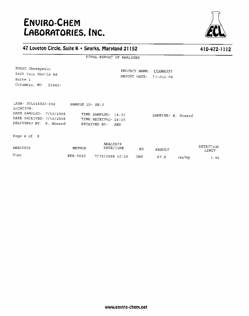
SS-1 SS-2SS-2
[DUPE] SS-3
MDE Non-Residential Soil
Clean-up Standard (1)(2)
MDE Central Maryland ATC (1)(3)
Aluminum 31,000 33,200 31,800 29,700 100,000 19,000Antimony <0.40 <0.37 <0.40 <0.41 41 6.8Arsenic 3.27 2.83 3.53 3.26 1.9 4.9Barium 98.9 111 99.2 103 20,000 99Beryllium 0.9 1.03 1.75 0.93 200 1.6Cadmium <0.40 <0.37 <0.40 <0.41 51 1.1Calcium 1,900 2,700 2,150 2,000 na 12,000Chromium, Total* 83.4 81.4 133 62.3 150,000 30Chromium, Hexavalent <2.20 <2.16 <2.16 <2.28 310 naCobalt 17.3 16.3 15.7 17.6 na 33Copper 32.1 30.6 29.8 29.7 4,100 42Iron 30,800 27,900 38,600 30,100 72,000 26,000Lead 24.3 29.3 26.7 25.3 1,000 61Magnesium 3,870 4,750 4,360 4,080 na 3,700Manganese 781 742 780 791 2,000 1,400Mercury <0.080 0.096 <0.079 <0.083 31 0.14Nickel 24.7 25.6 23.2 27.1 2,000 22Potassium 2,500 3,300 2,570 2,680 na 2,600Selenium 0.91 0.89 0.91 0.92 510 1Silver <0.80 <0.75 <0.79 <0.83 510 1Sodium 145 202 121 167 na 230Thallium <0.40 <0.37 <0.40 <0.41 7.2 1.5Vanadium 60.8 56.3 62.5 56.2 100 35Zinc 44 67.6 55.9 48.6 31,000 73
Table Notes:TAL (Target Analyte List) Metals Analytical Method: EPA Method 6020Hexavalent Chromium Analytical Method: EPA Method 7196Amg/Kg - milligrams per kilogram or parts per million (ppm)
< - Analyte Not Detected Above Specified Sample Quantitation Limit (SQL)Bold - Detected Analytena - Not Applicable
(1) Reference: State of Maryland Department of the Environment Cleanup Standards for Soil and Groundwater, March 2008.
Concentration (mg/kg)
Table 1Stansbury Park
Assessment of Existing Geosynthetic Cap and Surface Soil Sampling EventSurface Soil Sample Analytical Results
July 10, 2008
Target Analyte List Metals and Hexavalent Chromium
Analyte
(2) Table 1 - Generic Numeric Cleanup Standards for Groundwater and Soil (3) Appendix 2 - Attachment 2 - Anticipated Typical Concentrations (ATCs)/Reference Levels in the State of Maryland
* The MDE Residential Soil Clean-up Standard for Trivalent Chromium was used to evaluate the Total Chromium concentrations. This evaluation was done in this manner because Hexavalent Chromium was not detected and because the MDE Residential Soil Clean-up Standard for Total Chromium is the same as that for Hexavalent Chromium to conservatively account for unspeciated Hexavalent Chromium concentrations.

Test Pit TH-1 TH-2 TH-3 TH-4 TH-5 TH-6 TH-7 TH-8
Northing 39° 15' 34.751" N 39° 15' 35.310" N 39° 15' 35.957" N 39° 15' 35.898" N 39° 15' 36.190" N 39° 15' 35.271" N 39° 15' 34.570" N 39° 15' 35.116" N
Easting 76° 30' 01.476" W 76° 30' 01.368" W 76° 30' 01.439" W 76° 30' 00.448" W 76° 30' 00.010" W 76° 30' 00.195" W 76° 30' 01.059" W 76° 30' 00.676" W
Sample Point SS-1 SS-2 SS-3 SS-2 [DUPE]
Northing 39° 15' 36.016" N 39° 15' 36.106" N 39° 15' 36.247" N 39° 15' 36.106" N
Easting 76° 30' 01.435" W 76° 30' 00.620" W 76° 30' 00.065" W 76° 30' 00.620" W
Location Description
21.5' down slope from Well #2, near
TH-3
31' down slope from path, near
TH-4
21.5' down slope from path, near
TH-5
31' down slope from path, near
TH-4Soil Sample Description
Tan, dry, Clayey SILT
Tan, dry, Clayey SILT, little Gravel
Brown, moist, Clayey SILT
Tan, dry, Clayey SILT, little Gravel
Notes:TH = Test HoleSS = Surface Soil, samples collected @ 3-4 inchesCoordinates are Latitude/Longitude
July 10, 2008
Table 2Stansbury Park
Assessment of Existing Geosynthetic Cap and Surface Soil Sampling EventTest Hole and Surface Soil Sample Location Coordinates