Negro Canyon Watershed Assessment - Foriver · The Sediment Source Control Handbook ... and water...
38
Negro Canyon Watershed Assessment Prepared by Kevin Drake, Gerald Dion and Michael Hogan Integrated Environmental Restoration Services Matt Kiesse River Run Consulting Prepared for Beth Christman Truckee River Watershed Council May 28, 2010
Transcript of Negro Canyon Watershed Assessment - Foriver · The Sediment Source Control Handbook ... and water...

Negro Canyon Watershed Assessment
Prepared by Kevin Drake, Gerald Dion and Michael Hogan
Integrated Environmental Restoration Services
Matt Kiesse River Run Consulting
Prepared for Beth Christman
Truckee River Watershed Council
May 28, 2010

Table of Contents
Chapter 1. Introduction ................................................................................... 1 Problem Statement and Need for Assessment ........................................................ 1 Watershed Assessment Goals ............................................................................... 1 About Truckee River Watershed Council ................................................................ 2 The Sediment Source Control Handbook ................................................................ 2 Assessment Process ............................................................................................. 5
Chapter 2. Negro Canyon Setting .................................................................... 6
Location and General Setting ................................................................................ 6 Ownership and Land Uses .................................................................................... 6 Geology .............................................................................................................. 7 Elevation, Aspect and Topography ........................................................................ 7 Hydrology ........................................................................................................... 7 Geomorphic Processes and Landforms .................................................................. 9 Stream Reach Delineation .................................................................................. 11
Chapter 3. Human Disturbance and Effects on Watershed Function ............ 13
Development in the Watershed ........................................................................... 13 Impacts on Stream and Watershed Function ........................................................ 15
Chapter 4. Description of Problem Areas and Road Segments ...................... 19
Areas of High Erosion ........................................................................................ 19 Roadway Classification ....................................................................................... 24 Selected Photographs of Erosion Problem Areas ................................................... 24
Chapter 5. Defined Projects ........................................................................... 30
General Road Removal and Treatment Approaches .............................................. 30 Road Design and Maintenance Considerations ...................................................... 31 Prioritization of Road-Drainage Interactions and Road Segments ........................... 33 Description of Projects ....................................................................................... 33
Literature Cited ............................................................................................. 36
Chapter 1. Introduction
Problem Statement and Need for Assessment Negro Canyon has been impacted by many waves of human use, from grazing to logging to off-highway vehicle use. These impacts have and are contributing to water quality degradation within the larger Truckee River drainage. Water leaving the Negro Canyon watershed is not polluted with chemicals and toxins, but is polluted instead with sediment. This sediment can cause problems for aquatic organisms, provide excess nutrients, and reduce dissolved oxygen concentration in surface waters. Every sub-watershed of the Truckee River, including Negro Canyon, has been impacted by human use. Many of these impacts, such as road construction, have increased erosion and sediment transport and contributed to the Truckee River being listed as an impaired waterbody (303d) within the Clean Water Act. In large rainstorms, large amounts of sediment have been observed eroding from the roads of Negro Canyon into Donner Lake via Gregory Creek. Many large gullies are evident long after storms. Gregory Creek has been impacted from road construction and several headcuts have developed in the creek, leading to even more erosion and degradation of riparian and in-stream habitat. However, the interaction of the road network and Gregory Creek and its tributaries is complex. For example, at many sites in-stream degradation is readily apparent, but the specific cause/trigger of the degradation may be linked to any number of upstream sources. Negro Canyon is important for other values beyond water quality. Negro Canyon is part of a habitat corridor within the proposed Castle Peak Wilderness Area. The canyon is also provides important fawning habitat for the Loyalton deer herd. As a well-used summer and winter recreation site, Negro Canyon is a highly visible location for conservation efforts and education. The Negro Canyon Watershed Assessment has been conducted to identify a set of targeted restoration actions based on knowledge of the past impacts and the root cause of each erosion hotspot. The cause of an erosion hotspot might not be immediately evident. In the same way as a high fever is a symptom of the flu, a local erosion hotspot is often a symptom of a problem higher in the watershed.
Watershed Assessment Goals The overarching goal of the watershed assessment is to understand the current conditions of the watershed in the light of past impacts and to recommend actions that will improve the watershed condition. The specific goals include:
• Assess the geomorphic condition of the watershed.
• Assess the condition of the waterways in the watershed.
• Evaluate upland sources of erosion, primarily from roads and human activity.
Negro Canyon Watershed Assessment 1

Negro Canyon Watershed Assessment 2
• Define specific actions to improve watershed condition.
• Group actions into manageable projects for implementation.
About Truckee River Watershed Council The Truckee River Watershed Council (TRWC) was founded in 1998 to protect and restore the water quality and the biological resources of the Truckee River. TRWC works to accomplish it mission by identifying, coordinating, funding, and implementing restoration and preservation projects related to the health, beauty, and economy of the watershed. Combining sound science and a deep understanding of the region’s values, TRWC focuses on the root causes of threats to the Truckee River watershed. TRWC works in a non-confrontational manner, emphasizing collaboration through a series of stakeholder committees and volunteer-based programs. Volunteer-based programs include Truckee River Day, an annual river restoration day that draws 400-800 volunteers, and the Adopt-a-Stream Program, where volunteers measure water quality of local creeks and streams throughout the year.
The Sediment Source Control Handbook The Sediment Source Control Handbook (Hogan and Drake 2009) provides a new type of adaptive management-based roadmap for anyone responsible for erosion control, restoration and water quality protection. The Handbook has several sections. First, it offers a set of guiding principles for planning, implementing, and measuring sediment source control projects within an adaptive management framework. Second, the Handbook describes specific treatment tools and approaches to help practitioners put the guiding principles into action. Lastly, the Handbook includes a focused literature review that summarizes the current state of knowledge related to erosion processes and upland restoration treatment techniques. The Sediment Source Control Handbook provides 16 guiding principles for planning, implementing and monitoring sediment source control projects. Each principle has one or more goals that further define the guiding principle (see Box 1). The project team used these guiding principles in conducting the Negro Canyon Watershed Assessment and believes that these principles will be highly useful in carrying out and improving the effectiveness of restoration efforts in Negro Canyon over time.

Guiding Principles and Goals
Planning Principles
GP-1 Identify the need for action and/or the problem
To clearly understand both the need, or ‘trigger’, for taking action and the specific problem(s) being addressed.
GP-2 State project goals and objectives
To define the desired project outcome(s).
GP-3 Define success
To define success in quantitative terms wherever possible so that the project outcome (at a specific point or points in time) can be clearly measured and understood.
GP-4 Assemble the project team
To identify and assemble appropriate planning, implementation, and monitoring personnel that will assure the best project outcome, and include, to the extent appropriate, other interested/invested individuals.
GP-5 Assess strategies to develop a site-specific implementation plan
To develop a sediment source control implementation plan that is based on specific site conditions and that targets clearly identified outcomes.
Implementation Principles
GP-6 Train staff and associated personnel
To increase the level of awareness and understanding of the sediment source control program and build competence in all staff involved in project treatment activities as well as those who are not.
GP-7 Oversee and document activities
To oversee implementation of treatment activities in order to ensure proper implementation of planned treatments; document implementation of treatments in the form of ‘as-builts’ and/or other implementation monitoring documentation; and for contracted projects, to provide assurance that the contractor is doing the best job possible, thus providing high value to the owner.
Sediment Source Control Handbook Box 1
Negro Canyon Watershed Assessment 3

Guiding Principles and Goals
GP-8 Protect or optimize hydrologic function
To maintain or create site conditions where hydrologic function, especially surface hydrology, is accommodated and does not degrade the site or the watershed.
GP-9 Protect or optimize soil function
To create soil physical and biological conditions that optimize water infiltration, have robust and stable nutrient cycling, and support sustainable plant and soil microbial communities.
GP-10 Protect or optimize mulch and surface protection
To provide surface cover and protection as the first line of defense against erosive forces and, to provide long-term nutrient input to system (when applicable).
GP-11 Protect or optimize appropriate vegetation community
To apply the appropriate plant materials to achieve project goals.
GP-12 Protect project area from further disturbance
To reduce or eliminate post-project disturbance in order to maximize treatment benefits.
Monitoring Principles
GP-13 Performance monitoring
To assess project performance in a quantifiable manner against project success criteria and to gather information for a number of subsequent uses, as described in Guiding Principles 14, 15, and 16.
GP-14 Follow up treatment and management response
To address problem areas that fail to meet success criteria so that they can be brought up to acceptable levels (as defined by success criteria), and to apply additional resources (water, seed, fertilizer, etc.) that may be needed in subsequent seasons to assure the success of certain treatments.
GP-15 Future project improvement
Use information and data from existing and past projects to improve future projects.
GP-16 Information sharing
Share useful project information so that other project planners, implementers, and assessment personnel can improve their practices.
Box 1 (continued)
Sediment Source Control Handbook
Negro Canyon Watershed Assessment 4

Assessment Process The project team worked together to develop a project scope and approach designed to achieve the project goals. The project-planning phase ended after agreement on the project scope. Field evaluations began with the production of field GIS maps and continued with repeated visits to evaluate conditions and to describe projects. The final phase is to develop an implementation plan for the watershed. Figure 1-1 outlines the steps in the assessment process.
Negro Canyon Watershed Assessment 5
Chapter 2. Negro Canyon Setting
Location and General Setting The Gregory Creek watershed is located within Nevada County, California, draining into Donner Lake on its west shore (see Map 2-1). The upper two-thirds of the watershed above Interstate 80, popularly known as Negro Canyon, is the primary focus of this assessment. This portion of the watershed is 1,027 acres in size. The watershed is a popular recreation site. The Donner Lake Rim Trail passes through the watershed, and many people bike or hike this section of the trail. Additionally, the area is used during the winter by snowmobilers and backcountry skiers. Negro Canyon drains into Donner Lake and eventually the Truckee River. Truckee River water quality is considered impaired due to excess levels of sediment by the Lahontan Regional Water Quality Control Board (LRWQCB). The LRWQCB is currently in the process of implementing a Total Maximum Daily Load (TMDL) for sediment in the Truckee River watershed to protect and restore beneficial uses of water that have been impaired by sediment.
Ownership and Land Uses Map 2-2 illustrates ownership parcels within the Negro Canyon watershed. There are six landowners within the watershed, including Tahoe Donner Association (290 acres), Truckee Donner Land Trust (248 acres), US Forest Service (237 acres) and three private landowners (252 acres).
Easements and Access Requirements There are two primary transportation easements in the watershed. The first is the Donner Lake Rim Trail. The public is allowed to hike, bike, and ride horses on the trail. The segment within the watershed is three miles long. The second easement is road that crosses from the bottom of the watershed to the western edge. The public is allowed to use this road to access US Forest Service lands. There is also a passage easement that follows the US Forest Service easement but provides access to the private land to the north. Tahoe Donner Association would like to maintain road access to their lands for fire suppression and fuels management. Two gates exist within the watershed to control vehicle access. The first is along the southern roadway and the second is in the middle of the watershed between the USFS and Tahoe Donner Associations parcel.
Utilities and Other Features An overhead power line runs across the watershed (Map 2-3). Many spur roads have been created to access the power poles. Additionally, vegetation was cleared under the power lines in summer 2008. An ATT communication cable runs along the southern boundary of the watershed along the roadway.
Negro Canyon Watershed Assessment 6

Negro Canyon Watershed Assessment 7
Geology Most of the watershed is underlain by volcanic rocks of Miocene age (7-23 million years ago). Much of the Sierra crest is composed of granitic rock, but Negro Canyon is just east of this area and only scattered outcrops of older Cretaceous (70-145 million years ago) granitic rock occurs on the west side of the watershed. Although the basement rocks in the watershed consist of these two major types, sediments at the surface on the valley floor and extending some distance up the valley walls are comprised of more recent glacial deposits. Deposits from both the Tioga glaciation (the most recent glacial period, 14,000-25,000 years ago) and the Tahoe glaciation (40,000-200,000 years ago) are recognized1. Glacial deposits in Negro Canyon are striking. They consist of granitic rocks plucked and eroded from the Sierra crest and transported glacially to Negro Canyon, where they were deposited on the predominantly volcanic terrain. Large, light-colored granitic erratics2 are easily identifiable against the reddish-gray landscape typical of volcanic rocks. The large scale of glaciation represented by these deposits in Negro Canyon has had an important role in the development of modern landforms.
Elevation, Aspect and Topography At the bottom of the watershed, Gregory Creek enters a culvert at the upstream side of the highway at an elevation of about 6,350 ft. The highest point within the watershed is about 7,800 ft (Map 2-4). A majority of the watershed area lies between 6,500 ft and 7,000 ft. The watershed drains mostly to the south, as such there are few north-facing slopes. Most of the watershed is west-facing to south-facing to east-facing. In general, the overall relief is steep. Slopes on the east side of the watershed are especially steep.
Hydrology Average annual precipitation, measured at Donner State Memorial Park (Station ID 042467), is about 40.3 inches. This weather station is at a lower elevation than Negro Canyon, so precipitation in the project area is likely higher. Donner Summit receives over 50 inches of precipitation per year. Most precipitation falls between the months of November and March. Although this precipitation tends to arrive as snowfall, it can also occur as rain. Summers tend to be relatively dry, though isolated thunderstorms can result in high rates of rainfall. Figure 2-6
1 A geologic map of the area was reviewed but, unfortunately, permission for use in this publication was withheld. 2 A glacial erratic is a rock transported into an area of different geologic composition
Figure 2-5. Granitic Erratics B ld

represents monthly averages for snowfall, snow depth, and total precipitation at Donner State Memorial Park. Figure 2-6. Average snowfall, snow depth, and total precipitation for Donner Memorial State Park (ID 042467), which is about 3 miles to the east of Negro Canyon and 1,000 feet lower in elevation.
-5.0
0.0
5.0
10.0
15.0
20.0
25.0
30.0
35.0
40.0
45.0
Inch
es
Ave Total Precip. 2.0 4.7 6.8 7.2 6.3 5.4 2.7 1.5 0.8 0.4 0.5 0.8
Ave Total Snowfall 2.0 14.3 32.4 39.9 39.2 34.6 17.9 3.5 0.3 0.0 0.0 0.2
Ave Snow Depth 0.0 2.0 11.0 22.0 29.0 26.0 13.0 2.0 0.0 0.0 0.0 0.0
Oct Nov Dec Jan Feb Mar Apr May Jun Jul Aug Sep
Average Snowfall
Average Snow Depth
Average Total Precipitation
In Negro Canyon, runoff and stream flow are produced primarily by snowmelt. Spring melting of the snowpack is a gradual process that occurs from May through July as average temperature increases. Generally, the largest runoff and stream flow rates for a given year are generated by snowmelt, with exceptions noted in the following paragraph. The average annual flood (i.e. the typical snowmelt flood) for Coldstream Creek, a nearby drainage with a catchment area of 12.5 square miles, was calculated to be about 300 cubic feet per second (cfs). Given that the Negro Canyon watershed is about 1/10 the size of Coldstream Creek, the average annual snowmelt flood is likely somewhat less than 30 cfs at the Interstate 80 crossing. Even intense snowmelt of large snow packs is unlikely to result in stream flow of more than about twice this annual average. Larger runoff and stream flow rates occur far less frequently, but are still quite common on a decadal time scale (see Table 2-1). These events are caused by heavy precipitation occurring between November and January, either on existing snowpack or on saturated soils. Runoff rates are high due to two factors: intense precipitation and low infiltration rates into watershed soils. Melting snow can also contribute to runoff, but it is generally considered
Negro Canyon Watershed Assessment 8
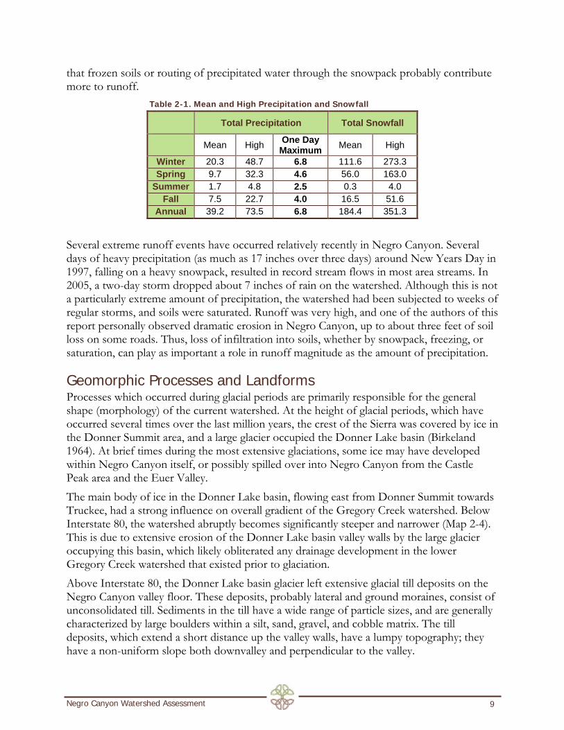
that frozen soils or routing of precipitated water through the snowpack probably contribute more to runoff.
Table 2-1. Mean and High Precipitation and Snowfall
Total Precipitation Total Snowfall
Mean High One Day Maximum Mean High
Winter 20.3 48.7 6.8 111.6 273.3 Spring 9.7 32.3 4.6 56.0 163.0
Summer 1.7 4.8 2.5 0.3 4.0 Fall 7.5 22.7 4.0 16.5 51.6
Annual 39.2 73.5 6.8 184.4 351.3 Several extreme runoff events have occurred relatively recently in Negro Canyon. Several days of heavy precipitation (as much as 17 inches over three days) around New Years Day in 1997, falling on a heavy snowpack, resulted in record stream flows in most area streams. In 2005, a two-day storm dropped about 7 inches of rain on the watershed. Although this is not a particularly extreme amount of precipitation, the watershed had been subjected to weeks of regular storms, and soils were saturated. Runoff was very high, and one of the authors of this report personally observed dramatic erosion in Negro Canyon, up to about three feet of soil loss on some roads. Thus, loss of infiltration into soils, whether by snowpack, freezing, or saturation, can play as important a role in runoff magnitude as the amount of precipitation.
Geomorphic Processes and Landforms Processes which occurred during glacial periods are primarily responsible for the general shape (morphology) of the current watershed. At the height of glacial periods, which have occurred several times over the last million years, the crest of the Sierra was covered by ice in the Donner Summit area, and a large glacier occupied the Donner Lake basin (Birkeland 1964). At brief times during the most extensive glaciations, some ice may have developed within Negro Canyon itself, or possibly spilled over into Negro Canyon from the Castle Peak area and the Euer Valley. The main body of ice in the Donner Lake basin, flowing east from Donner Summit towards Truckee, had a strong influence on overall gradient of the Gregory Creek watershed. Below Interstate 80, the watershed abruptly becomes significantly steeper and narrower (Map 2-4). This is due to extensive erosion of the Donner Lake basin valley walls by the large glacier occupying this basin, which likely obliterated any drainage development in the lower Gregory Creek watershed that existed prior to glaciation. Above Interstate 80, the Donner Lake basin glacier left extensive glacial till deposits on the Negro Canyon valley floor. These deposits, probably lateral and ground moraines, consist of unconsolidated till. Sediments in the till have a wide range of particle sizes, and are generally characterized by large boulders within a silt, sand, gravel, and cobble matrix. The till deposits, which extend a short distance up the valley walls, have a lumpy topography; they have a non-uniform slope both downvalley and perpendicular to the valley.
Negro Canyon Watershed Assessment 9

Till deposits in the Negro Canyon valley floor, extending from approximately Interstate 80 upstream, are an important influence on watershed gradient. Deposited on the margin of the Donner Lake glacier, the till raised the valley floor perpendicular to the main axis of the Negro Canyon valley, substantially reducing valley gradient upstream of Interstate 80.
Modern Drainage Development When ice disappeared from the region about 15,000 years ago, the main erosive and depositional force in the Gregory Creek watershed became fluvial (running water). Sediment production was high, as fluvial processes reworked the landforms created by ice. In the entire glacial cycle, deglaciation (ice melting) probably results in the highest sediment yield. It is important to note that glacial processes in this portion of the Sierra were extensive and massive, and resulting modification of glacial landforms by modern fluvial systems is ongoing. Benn and Evans (1998) note that in mountainous landscapes, reworking of glacial landforms persists for many thousands of years, likely until the next glaciation. Downstream of Interstate 80, the main fluvial modification of glacial landforms has been the development of the Gregory Creek fluvial valley in the Donner basin valley walls that had been extensively eroded by the Donner Lake glacier. This process has occurred slowly, as the Gregory Creek valley is poorly developed. The relatively small Gregory Creek watershed does not produce enough runoff to have created a larger valley since deglaciation. Upstream of Interstate 80, modern fluvial drainage has reworked the extensive till deposits left by the Donner Lake glacier. Again, because watershed area and runoff are relatively small, the modern streams are not capable of a wholesale reworking of the extensive till deposits. Rather, the modern channels have entrenched within the till deposits; as finer sediments in the till are eroded and transported downstream, the drainage enlarges and deepens. This process continues until the channel reaches bedrock or self-armors through the recruitment of larger boulders from the till. Drainage development has proceeded differently at various locations in the watershed depending on the depth and nature of the till and the size of the drainage. On the west side of Negro Canyon, the main drainage is well-developed and has occupied the lateral margin of till deposits. This area is generally in the lee of the Negro Canyon western valley wall with respect to the Donner Lake glacier, and till deposits are likely shallower. This drainage has occupied the margin of the till, where it contacts the valley wall, and is highly entrenched. Erosion has proceeded down to volcanic basement rock in many locations. On the east side of Negro Canyon, individual drainages are smaller and the till is more extensive. As a result, in middle portion of the valley, the channels are entrenched entirely in till, with boulders eroded from the till forming the channel bottom. At the upper end of the east side drainage, the main channel occupies the lateral margin of till deposits in some locations, and volcanic basement rocks are seen in the channel. All of the channels on the Negro Canyon valley floor are basically of this entrenched form. The surrounding land surface is not a floodplain in a geomorphic sense; it was not formed by modern fluvial processes, but is instead a glacial till. Fluvial floodplains, where they exist in the mainstem channels, are small features within the larger entrenched landform. It is
Negro Canyon Watershed Assessment 10

important to recognize that the process of fluvial entrenchment within glacial tills is probably still ongoing, and some erosion in stream channels can be attributed to this process. As noted above, moraines deposited by the Donner Lake glacier created a discontinuity in valley slope around the location of Interstate 80. The Donner Lake moraines in Negro Canyon formed a sort of “bench” perpendicular to the axis of the canyon, reducing valley gradient upslope. For a few hundred feet upstream of Interstate 80, it appears that Gregory Creek likely has created a floodplain since deglaciation, through deposition of sediment in the low gradient valley floor upstream of the moraines. Vegetation signatures in historic aerial photographs suggest that riparian vegetation was extensive on the valley floor. This area has been highly modified by human disturbance, including fill from Interstate 80 and adjacent roads, and little of the original floodplain surface remains.
Stream Reach Delineation Stream channels were classified and delineated for the Negro Canyon watershed on the basis of criteria relevant to restoration objectives and reflective of the underlying geomorphic landforms and processes described above. The criteria used to delineate channel types were:
• Flow regime (perennial versus non-perennial)
• Slope
• Degree of entrenchment
• Predominant bed materials (bedrock, sorted till, alluvium) Based on these criteria, four channel types were identified within the watershed (Table 2-2). These channel types were then applied to streams in the watershed (Map 2-5). Because breaks between channel types are seldom discrete in nature, and a high degree of variability is common in stream channels, short segments within these reaches may not conform to all of the criteria for the channel type. Given this constraint, the channel typing delineation does tend describe the reach as a whole. Table 2-2. Stream channel types identified in the project area.
Channel Type Flow Regime Slope Predominant Bed
Material Entrenchment
Headwaters non-perennial >10% bedrock low
Entrenched Tributary non-perennial 5-10% sorted till moderate
Entrenched Mainstem perennial <5% bedrock/sorted till high
Alluvial Mainstem perennial <5% alluvium low
Negro Canyon Watershed Assessment 11

Negro Canyon Watershed Assessment 12
Channel Type Descriptions
Headwaters The Headwaters channel type describes the steepest channels near the top of the watershed, above the deposited till in the valley bottom. The channel is primarily composed of bedrock. Entrenchment is low due to the bedrock control. Both suspended sediment and bedload are transported within these channels, but do not tend to be deposited. Rather, sediment is supplied to downstream reaches. Flow is ephemeral, occurring during snowmelt or storms. Riparian vegetation is very limited due to lack of substrate and summer water.
Entrenched Tributary The Entrenched Tributary channel type is found on deposited glacial till, from the Headwaters channel type downstream to the mainstem channels. These channels are intermediate in slope, and are entirely entrenched within till deposits. The bed of the channel is thus composed of sorted till, from gravels to boulders in size. Entrenchment is moderate, as the channels have cut down somewhat into till deposits, but the degree of entrenchment is limited both by the size of the sub-watershed contributing flow and the large boulders recruited during incision into the till. As with Headwaters channels, sediment is transported within these channels but does not tend to be deposited, and is supplied to downstream reaches. Flow is ephemeral, occurring during snowmelt or storms. Riparian vegetation is very limited due to lack of substrate and summer water, although narrow bands of willows or alder are found in some locations.
Entrenched Mainstem Two stream reaches are classified as Entrenched Mainstem channel types; the East and West Forks of Gregory Creek. The Mainstem channel type is found on or at the margin of glacial till. These channels are relatively low in slope, and are highly entrenched within till deposits. The bed of the channel is a mixture of sorted till, bedrock outcrops, and some limited areas of fluvial deposits. Entrenchment is high, as the mainstem channels have more erosive power due to perennial flow and a larger watershed area. Sediment is both transported and, to a limited extent, deposited within these channels. Riparian vegetation is more common, typically found on small patches of deposited alluvium.
Alluvial Mainstem This channel type is found only in one limited area, just upstream of the Interstate 80 crossing. Surrounding land surfaces are a geomorphic floodplain, consisting of fluvial sediments deposited by the modern Gregory Creek. The Alluvial Mainstem channel type is relatively low in slope. The bed of the channel consists of fluvial deposits. Entrenchment is low. Sediment is both transported and deposited within these channels. Riparian vegetation is abundant along the channel margin and the surrounding floodplain.

Chapter 3. Human Disturbance and Effects on Watershed Function In this chapter, we review the history of human development and disturbance within the Gregory Creek watershed, and evaluate potential impacts on watershed function, including erosion and sediment production. Because restoration efforts are most effective when directed toward portions of the watershed that have been altered through human practices, the primary objective of this analysis is to differentiate natural function (which often includes erosion) from function that is the result of human alteration. In the first section of this chapter, we briefly review the history of human development in the entire Gregory Creek watershed. In the second section, the resulting impacts on watershed and stream function are described.
Development in the Watershed
Central Pacific Railroad and Comstock Mines: mid to late 1800’s As noted in a watershed assessment for Coldstream Canyon (River Run Consulting 2006), a neighboring watershed directly south of Donner Lake, construction of the Central Pacific Railroad in the mid-1860’s created a high demand for local resources, primarily timber, in the local region. At this time, timber harvest probably began in Gregory Creek, both to obtain lumber for the railroad and to provide heating fuel. The demand for lumber in the Comstock mines near Virginia City was also high during this period, especially for long, clear large-diameter lumber to stabilize shafts. During this period, harvest was done by hand, and timber was hauled by horse or mule. Although it was possible to move earth on a large-scale, such as for the construction of the railroad, such enterprises required massive amounts of labor and draft stock. Timber harvest was therefore confined to more accessible areas on shallower slopes. And, because moving timber required so much effort, efforts were focused on the most valuable species—larger trees such as sugar pine that yielded straight, clear lumber. In larger watersheds with abundant timber resources, high demand during this period resulted in extensive development of transportation resources and mills, including small-gauge railroad spurs. In Coldstream Canyon, for example, several mills operated in the late 1800’s (River Run Consulting 2006). The Gregory Creek watershed, however, is relatively small with limited timber resources, and, due to the steep topography, difficult to access. There is no evidence of the development of roads or other infrastructure during this period in the watershed. This background suggests that timber harvest during this period in the Gregory Creek watershed was probably limited to the extraction of large, valuable trees near Donner Lake for railroad construction. There may have also been some limited harvest of easily accessible trees for local use as firewood, but most of the upper watershed was likely relatively untouched.
Negro Canyon Watershed Assessment 13

Local Mills: 1900-1940 Two mills operated locally in the early 1900’s. One was located in Billy Mack Flat, and the other at the east end of Donner Lake (Wilson 1992). The Davies Mill on Donner Lake operated from 1903-1904, cutting about 25 million board-feet of timber at the west end of the lake. Timber was transported to the mill on the lake. The mill in Billy Mack Flat operated from 1904-1909. A large pulp mill in Floriston was in operation throughout much of this period, receiving a great deal of fir from the Coldstream watershed, and mills were active in the Truckee area. Hobart Mills was active until about 1936. Some of the timber for the local mills in the early part of the 1900’s certainly came from the Gregory Creek watershed, especially from the lower part. It is unclear how extensively the upper portion of the watershed might have been logged during this period. The earliest aerial photograph of the watershed dates from 1939 (Map 3-1). Some harvest activities are clearly evident on the east crest of the basin. This harvesting could have fed the early mills but, given the location, it seems more likely that this lumber probably went to Truckee or Hobart Mills, probably later in the period. The Central Pacific Railroad had an enormous appetite for cordwood fuel. Large stacks of cordwood fuel were concentrated along railways (Wilson 1992). This demand probably resulted in localized firewood cutting in the watershed. Cordwood stacks were also a significant fire hazard, and many costly fires occurred along railroads.
Mechanized Logging, Road Construction, and Residential Development: 1940-present This was the main period of development and human disturbance in the Gregory Creek watershed. Extensive logging occurred and caused the construction of haul and skid roads. Residential and commercial development occurred along the Donner Lake shoreline, and Interstate 80 was constructed. Until around 1940, steam provided the only source of power for mechanized logging. With the advent of the diesel engine, mechanized logging became widely available, and the construction of roads and skid trails far more prevalent. By 1952, the main system of logging roads had been constructed in Negro Canyon (Map 3-2). Logging was underway on much of the southeastern side of the watershed at this time, with extensive skid trail development. Logging also began to extend up the southwestern ridge. By 1966 most of the lower portion of Negro Canyon, including the western side, had been logged, and logging activity was clearly ongoing (Map 3-3, southern portion of watershed only; and Map 3-4). By 1983, logging activity had ceased, but most timber had been removed, with the exception of small patches in the southwest and northeast corners of the watershed (Map 3-5). A road was constructed around the shoreline of Donner Lake very early in the development of the area and is visible on the 1939 photograph. At this time, there are also other roads visible in the vicinity of the mouth of Gregory Creek. By 1966, the interstate and a local access road from Donner Pass Road had been constructed. Donner Pass Road had been paved, and buildings and other development features were constructed around the mouth of Gregory Creek.
Negro Canyon Watershed Assessment 14

In 2005, Caltrans chose the base of Negro Canyon as a location for a new salt and sand storage barn. Mountain Area Preservation Foundation (MAPF) worked with the Town of Truckee, Nevada County Supervisor Ted Owens, and State Senator Dave Cox to oppose the proposal. The reasons for opposition included the siting of the barn immediately adjacent to Gregory Creek, which posed a high risk of water quality impacts to the creek and Donner Lake, blocking of access to Negro Canyon during the winter, potential impacts to the migratory corridor of the Loyalton-Truckee deer herd, and potential import of weed seeds to the canyon mixed in with imported sand. Caltrans withdrew their proposal in 2006 after MAPF filed suit to require thorough CEQA review. By the end of this period, most development in the watershed was complete. Some additional residential development occurred in the middle portion of the watershed, between the interstate and the mouth, but was relatively limited in extent.
Impacts on Stream and Watershed Function
Direct Disturbance of Stream Channels Where Gregory Creek enters Donner Lake, an alluvial fan or delta has developed due to the abrupt change in slope and resulting sediment deposition. The channel was likely relatively dynamic on this fan and could change location during large floods. During construction of the Donner Pass Road and other commercial and residential development near the Gregory Creek mouth, the stream was channelized, resulting in the loss of riparian and aquatic habitat. In its current configuration, the stream is prone to flooding during major storms.
Figure 3-6. Western Slope of Gregory Creek
The construction of Interstate 80 required a massive fill throughout the Gregory Creek watershed. As noted in Chapter 2, in this area the stream may have had a fairly wide alluvial floodplain prior to human disturbance. The Interstate-80 fill probably covered a significant amount of functional riparian vegetation and meadow. Downstream of I-80, the creek enters a steep, confined reach. As the I-80 culvert discharges directly to this confined reach, downstream impacts of the highway are probably minimal. In the Negro Canyon portion of the watershed above I-80, roading for timber harvest operations has caused many direct channel impacts. Where the main road systems crossed the larger perennial channels, crossings were constructed of fill with culverts.
Negro Canyon Watershed Assessment 15

Culverts were often undersized, resulting either in erosion or aggradation and abandonment of the culvert. Timber harvest road crossings of ephemeral channels were usually constructed of fill and have caused major problems with channels. In most cases, the fill has eroded and the resulting sediment has passed downstream, impacting habitat, causing channel instability, and possibly even causing problems with channel stability on the alluvial fan near the mouth of the creek on Donner Lake. In some areas, particularly in the small, ephemeral channels draining the eastern slope of the watershed, channel fill at road crossings diverted flow down the road. Where flow finally left the road surface, a new channel was created downslope of the road, with resulting erosion and sediment production (Figure 3-6) In many cases, roads have become part of the drainage network due to their poor construction. On the main road system, very few efforts were made to direct water off the road surface. As a result, small drainages tended to be captured by the road. As flow concentrated, the road surface began erode, in essence becoming a new channel. Thousands of cubic yards of sediment have been produced in this erosion cycle throughout the watershed.
Impacts to Hydrologic Function Extensive timber harvest in the Negro Canyon watershed has had significant impacts to watershed function. As noted in the previous section, nearly the entire watershed was deforested between 1940 and 1980. Timber harvest on this scale has inevitable hydrologic consequences, primarily resulting in flashier (more rapid) and more concentrated runoff periods. Changes in watershed hydrology are due to a number of factors, including:
• removal of much of the forest canopy via timber harvest
• compaction of soils and decreased infiltration due to harvest activities
• interruption, capture, and surface routing of subsurface flows by the road and skid trail network
• capture, concentration and routing of surface flows by the road and skid trail network
Examples of these hydrologic impacts are abundant throughout the watershed today. Road cuts in the northeastern corner of the watershed were constructed on wetter slopes with spring influence, reintroducing shallow groundwater to road surfaces. Compacted soils on log landings and other heavily used areas have very low infiltration rates and are sources of surface runoff. Skid trails, even those with established shrubs and trees, still concentrate flows due to persistent soil compaction (Figure 3-7). Much of the road network captures and concentrates surface flow (Figure 3-8).
Negro Canyon Watershed Assessment 16

Figure 3-7. Historic skid trail showing signs of recent erosion.
Figure 3-8. Road capture of surface flow.
Although all of these impacts are common to timber harvest operations, the degree of impact on watershed function depends primarily on the extent of the disturbance. For example, one approach to analyzing cumulative watershed impacts is to calculate what is termed Equivalent Roaded Area (ERA). This approach recognizes the negative impacts of roading, and converts the area of all types of disturbance into an equivalent area of road. Values of ERA above 7% of the total watershed area are considered likely to have adverse impacts (River Run Consulting 2006). Heavy, ground-based logging is typically converted to ERA at a ratio of about 0.21 (River Run Consulting 2006). As heavy logging covered virtually 100% of the Negro Canyon watershed in the 1950’s and 1960’s, ERA in the late 1960’s would be at least 20%, not including the actual footprint of roads. Clearly, impacts to watershed function were highly likely. The specific impacts of timber harvest activities include increased local runoff rates, more rapid stream flow response to storm precipitation, and higher peak discharge in stream channels for a given level of precipitation than prior to logging activities.
Impacts on Erosion and Sediment Yield During and shortly after logging, erosion and sediment yield increased in areas directly affected by operations because of soil disturbance and increased runoff. Where disturbance was fairly light and the slope less steep, substantial recovery has occurred over time with revegetation. On steeper slopes, even relatively lightly disturbed areas such as low-traffic skid trails have continued to concentrate water and erode. This is especially prevalent on the east side of the watershed, where revegetation is less rapid due to somewhat drier conditions and poorer soils, yet some minor skid trails on the west side of the watershed are also actively eroding. Roads that saw substantial traffic during logging, often constructed with significant cut and fill, are causing highly accelerated erosion rates today in several ways. On the east side of the watershed, a series of roads cut across the ephemeral drainages, diverting flow down the road for a short distance, where it then reenters the slope below. Downslope of the roads,
Negro Canyon Watershed Assessment 17

Negro Canyon Watershed Assessment 18
the channels are flowing on glacial till deposits. The flow diversions caused by the roads resulted in a new cycle of channel formation as entrenchment within the glacial till occurred. The result is a complex maze of channels along the toe of the eastern hillslopes, most still actively eroding and producing sediment. The roads themselves are also actively eroding in many areas. Most were not constructed with water bars or other features to direct flow off the roads, and so the roads concentrate water during larger storms. As the roadbed erodes and degrades, additional flow is concentrated on the road surface, leading to more erosion, etc., in a reinforcing cycle. The eventual outcome is that these roads will become the channel network. Active erosion continues on many roads, especially during the rarer, large-runoff storms. Increased peak discharge resulting from timber harvest activities may have also contributed to increased erosion by impacting channel instability. Because most of the channels in the watershed are naturally entrenched, they can contain all of the water supplied to them. Increased peak discharges contained in these channels generate more erosive force and are probably exacerbating erosion. Finally, on a larger scale, timber harvest has likely made intense wildfire more common through the removal of stands of large timber, which tend to be resistant to intense wildfire. While fire may occur regularly in stands of large timber, it tends to be far less intense due to the lack of fuel on the forest floor. Following timber harvest, large amounts of slash provided ample fuel. In addition, highly flammable brush, such as manzanita, became established in harvest areas. The result was a devastating forest fire in the early 1960’s. When such a fire occurs, erosion and sedimentation rates increase dramatically on the bare soils. It is important to recognize that the Negro Canyon watershed had relatively high rates of erosion prior to human disturbance. Volcanic bedrock on the east slope, for example, has formed a very steep slope. Many of the rocks forming this slope, such as ash or lahar deposits, are easily eroded. As a result, sediment yield from this slope has likely always been relatively high. Other natural erosion sources would have included the steep streambanks of entrenched channels. Nevertheless, our site surveys and analysis have identified numerous specific locations within the watershed where human disturbance has directly increased erosion. Sediment supplied to the stream channels has negatively affected water quality, aquatic habitat, and downstream channel stability. In the next chapter, specific locations where human disturbance has impacted the watershed are identified.

Chapter 4. Description of Problem Areas and Road Segments
Areas of High Erosion Although a range of human uses in Negro Canyon have created significant erosion problems, the road network is the single largest of these in terms of sediment yield and hydrologic modification. The road network can be divided into three general categories: 1) old logging roads no longer used, 2) active roads with active easements, and 3) roads to access power lines. In general, the roads in this watershed were not designed to accommodate existing drainages. Many drainages do not have culverts. The culverts that do exist are either undersized or in need of maintenance. Two other significant problem areas are old log landings and two quarry areas. The log landings, while mostly revegetated, have modified drainage patterns. These new flow paths through and around the log landings are largely unstable and producing sediment. The two quarry areas (spots 34 and 35) are producing sediment due to steep slopes and the abundance of unconsolidated soils left over from mining activities. Each identified area of high erosion is described in Table 4-1, below.
Negro Canyon Watershed Assessment 19

Table 4-1. Areas of High Erosion. Note: Treatment feasibility is high for all areas. Therefore, feasibility was not included as a criterion in this table.
ID # Description Recommended Treatment Drainage
Modification Sediment
Production
1 Road crossing, some incision in channel upstream due to failure of crossing. Fairly stable now, priority low.
Rock channel at entrance of culvert and 20 ft US to reduce sediment supply. Low Low
2 Gully in photo 4, formed by concentration of flow off skid road. Short length.
Hand placement of rock and some revegetation. Low Low
3 Landing area and road across 2 drainages. Fill in west drainage has already failed; mostly stabilized.
Remove fill, grade channel and side slopes, place rock in channel to stabilize. High Moderate-High
4 Landing and road crossing in drainage. Much erosion of fill, which has extensively modified drainage.
Remove fill, grade channel and side slopes, place rock in channel to stabilize. High Moderate-High
5 Road up R3 reach. Altered drainage patterns, which has caused incision. Restore drainage with heavy equipment. Moderate Low-Moderate
6 Road fill in drainage, some failure in outboard toe. Remove fill. Low Low-Moderate
7 Fill in drainage in short R3 reach. Mostly stable, but toe is eroding and future potential for sediment delivery.
Remove fill, grade channel and side slopes, place rock in channel to stabilize. Low Low-Moderate
8
Road capture of large drainage at crossing. Flow diverted downstream about 50 yards, where new channel formed.
Remove fill, grade channel and side slopes, place rock in channel to stabilize. High High
9 Diversion of smaller drainage. Some erosion of fill. Remove fill. High Moderate
10
Road crossing at photo 47. At sometime in past, crossing may have failed, causing channel incision both upstream
Enlarge culvert and improve drainage on road. Stabilize banks in incised area. Low-Moderate Low-Moderate
Negro Canyon Watershed Assessment 20
Negro Canyon Watershed Assessment 21
ID # Description Recommended Treatment Drainage
Modification Sediment
Production
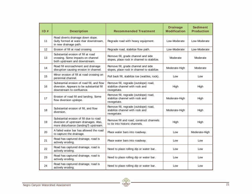
11 Road diverts drainage down slope. Gully formed at wate rbar downstream, in new drainage path.
Regrade road with heavy equipment. Low-Moderate Low-Moderate
12 Erosion of fill at road crossing. Regrade road, stabilize flow path. Low-Moderate Low-Moderate
13 Substantial erosion of fill at road crossing. Some impacts on channel both upstream and downstream.
Remove fill, grade channel and side slopes, place rock in channel to stabilize. Moderate Moderate
14 Road fill encroachment and drainage disruption causing erosion in channel.
Remove fill, grade channel and side slopes, place rock in channel to stabilize. Moderate-High Moderate
15 Minor erosion of fill at road crossing on perennial channel. Pull back fill, stabilize toe (wattles, rock). Low Low
16 Substantial erosion of road fill, and flow diversion. Appears to be substantial fill downstream to confluence.
Remove fill, regrade (outslope) road, stabilize channel with rock and revegetate.
High High
17 Erosion of road fill and landing. Some flow diversion upslope.
Remove fill, regrade (outslope) road, stabilize channel with rock and revegetate.
Moderate-High High
18 Substantial erosion of fill, and flow diversion.
Remove fill, regrade (outslope) road, stabilize channel with rock and revegetate.
Moderate-High High
19 Substantial erosion of fill due to road diversion of upstream drainages. Also, more disturbance (landing?) upstream.
Remove fill and road; construct channels to tie into historic channels. High High
20 A failed water bar has allowed the road to capture the drainage. Place water bars into roadway. Low Moderate-High
21 Road has captured drainage, road is actively eroding. Place water bars into roadway. Low Low
22 Road has captured drainage, road is actively eroding. Need to place rolling dip or water bar. Low Low
23 Road has captured drainage, road is actively eroding. Need to place rolling dip or water bar. Low Low
24 Road has captured drainage, road is actively eroding. Need to place rolling dip or water bar. Low Low

Negro Canyon Watershed Assessment 22
ID # Description Recommended Treatment Drainage
Modification Sediment
Production
25 Road has captured drainage, road is actively eroding. Need to place rolling dip or water bar. Low Low
26 Road has captured drainage, road is actively eroding. Need to place rolling dip or water bar. Low Low
27 Road has captured drainage, road is actively eroding. Need to place rolling dip or water bar. Low Low
28 Road has captured drainage, road is actively eroding. Need to place rolling dip or water bar. Low Low
29 This is a steep spur road that is no longer needed. The road is actively eroding.
Completely remove road and replant with grasses, shrubs, and trees. Low Moderate-High
30 Road has captured drainage, road is actively eroding. Need to place rolling dip or water bar. Low Low
31 Road has captured drainage, road is actively eroding. Need to place rolling dip or water bar. Low Low
32 Culvert is mostly blocked. Replace culvert and add rolling dip. Low Low
33 This is a steep spur road that is no longer needed.
Completely remove road and replant with grasses, shrubs, and trees. Low Moderate-High
34 Abandoned quarry was viewed from the road. Some signs of sediment leaving the area.
Regrade and fully restore quarry. High Moderate-High
35 Abandoned quarry was viewed from the road. Current OHV use is causing erosion.
Regrade and fully restore quarry. High High
36 Abandoned CALTRANS construction pad. The creek has been pushed to the side for construction pad.
Fully remove parking lot, relocate riparian area, and revegetate. High High
37 Roadway is capturing water, water bars not sufficient.
Create new water bars and redesign old water bars. Moderate Moderate
38 Roadway is capturing water, water bars not sufficient.
Create new water bars and redesign old water bars. Moderate Moderate
39 Old logging landing is eroding and Remove landing fill and re-contour High Moderate

Negro Canyon Watershed Assessment 23
ID # Description Recommended Treatment Drainage
Modification Sediment
Production
modify water flows. landscape, and replant native vegetation.
40 Old logging landing is eroding and modify water flows.
Remove landing fill and re-contour landscape, and replant native vegetation. High Moderate
41 Old logging landing is eroding and modify water flows.
Remove landing fill and re-contour landscape, and replant native vegetation. High High
42 Old logging landing is eroding and modify water flows.
Remove landing fill and re-contour landscape, and replant native vegetation. High Moderate

Roadway Classification To assist in the understanding of how roads are impacting the watershed, roads were classified using the following categories (see Map 4-1):
Abandoned Road These road segments are no longer in active use by vehicles. Most are old logging roads and some are currently used as recreational trails.
Actively Eroding Road These road segments are concentrating water flow and show signs of active erosion (e.g. rilling, deposition). However, there is no evidence that these roads are capturing water from seasonal/ephemeral drainages.
Drainage Capture These road segments are capturing water from an ephemeral/seasonal drainage and concentrating this flow along the road surface, causing substantial erosion and sediment transport. Road drainage capture typically results from either a blocked culvert or incomplete consideration and accommodation of surrounding drainage patterns during design and construction of the road.
Steep Eroding Shoulder These road segments have one or more steep shoulder (i.e. cut or fill slopes) that are eroding. Topsoil and associated organic matter are commonly removed or buried during construction of roads and adjacent slopes, leaving behind bare, compacted soils prone to ongoing erosion.
Normal Road These road segments do not exhibit accelerated erosion or evidence of concentrated water flow. However, by virtue of the fact that these roads consist of compacted, bare soil, some signs of erosion tend to be present and these “normal roads” still require regular maintenance to minimize risk of more acute erosion problems.
Selected Photographs of Erosion Problem Areas The following selected photographs illustrate some of the most acute erosion problem areas in Negro Canyon. These persistent sources of sediment transport are all highly treatable. These photographs were taken during the summer of 2008. Map 4-2 identifies the location of each photograph. A description of each photograph is provided in Table 4-2.
Negro Canyon Watershed Assessment 24

Photo 60. Looking up north road at gully created by road capture of water.
Photo 61. Looking up north road above photo 60 showing beginning of water capture.
Photo 65. Looking up slope to photo 67. There is no culvert or stable crossing where this drainage intersects the road.
Photo 66. Roadway capture of drainage. Note that water bar directs water off road into an area that has not historically functioned as a drainage.
Photo 72. Gully on road formed by captured drainage.
Photo 73. Old logging road exhibiting signs of erosion.
Negro Canyon Watershed Assessment 25

Photo 74. Short spur trail used by OHV riders with soil berm turned jump. This trail is a large source of erosion.
Photo 75. Main easement road. Note sediment deposited at water bar outlet in foreground.
Negro Canyon Watershed Assessment 26

Table 4-2. Photograph Descriptions (ID # links to Map 4-2; Bold text indicates photo provided above.)
ID # Photograph Description
1 Easternmost drainage in Negro Canyon. Road crossing looks like it blew out and has since been repaired. Photo 1 is of upstream end of culvert.
2 Same as in photo 1, looking at downstream end of culvert.
3 Same as in photo 1, looking at channel upstream of culvert.
4 Looking south off skid road – concentrated flow has formed small gully.
5 Upstream end of incision at HS1 caused by road fill failure. Note banks are lower than in Photo 3 and are stable.
6 Channel incised in moraine deposits. Note volcanic bedrock upslope in background of photo.
7 Eastern drainage fill at HS3, looking upstream.
8 Same as in Photo 7, looking downstream.
9 Headcut in volcanic soils, probably resulting from landing modifications DS at HS3. Part of HS3; mostly stabilized, but some erosion continues. Fix is handwork.
10 Gully in landing fill at HS4.
11 Looking upstream at upstream end of reach 3 in this drainage and bedrock channel above.
12 Small bedrock channel.
13 Looking downstream through R3 in this drainage. This is also HS5, where a skid road was constructed through the deposition Reach 3, causing a change in drainage and subsequent incision.
14 Evidence of incision in response to roading; note small hanging tributary.
15 Skid road turned into drainage; no sediment export.
16 Looking upstream from fill on road at HS6. Short R3 reach just upstream of the road, which transitions to R4 in photo background.
17 East facing western boundary slope. Bare spots likely skid roads. Note moraine deposits on south end.
18 Looking across canyon mouth to west toward Donner Summit, source of granitic boulders.
19 Stable road fill in small drainage.
20 Drainage upstream of road crossing; note bedrock.
21 Small tributary drainage at location of photo 20. Expose roots on trees indicate recent incision. Probably not due to incision of main stem. Checked the drainage above this photo--no evidence of flow diversion, etc. This small drainage may have been used as a skid trail.
22 Road fill at HS7.
23 At HS8, looking up road to diversion point.
24 Gully where drainage at HS8 has been diverted over edge of road.
25 Looking at drainage diversion at HS9.
26 Perennial east valley channel. Entrenched, type R5. Banks stable except where impacted by road fill or flow diversion. Some sediment stored in the channel.
27 Looking upstream in drainage. Note bedrock outcrop in right foreground. Lower portion appears incised due to interaction with road downstream. Upper portion stable; moraine influence is lessened in drainages at this elevation. Mostly entrenched in volcanics.
28 Looking upstream; bedrock control. Just upstream of skid crossing, which has caused overall aggradation. No evidence of higher incision surface. This appears to be undisturbed condition for these steep channels in volcanics. High-energy environment with extreme summer drought.
29 Skid road crossing, channel incised through fill, but mostly stabilized now. Example of minimal long-term channel impacts of crossings in bedrock channels.
Negro Canyon Watershed Assessment 27

Negro Canyon Watershed Assessment 28
ID # Photograph Description
30 Road across slope face on the west side of main eastern canyon channel. Note creation of small drainages below knobs due to flow diversion.
31 Skid trail erosion due to lack of vegetation, flow concentration.
32 Log on skid trail storing sediment.
33 This drainage is first to show spring influence moving north and higher in elevation. Looking upstream; typical gully in volcanics.
34 Drainage in photo 33, looking downstream. Note wetland vegetation, and gully has filled. In wetter areas, gully drainages are stable and vegetation allows them to capture and store sediment from upslope.
35 Looking upstream at bedrock gully; spring influence downstream.
36 Looking upstream at bedrock gully; spring influence downstream.
37 Shrub in channel; note sediment deposition.
38 Looking downstream in gully, bedrock bottom.
39 East-facing hillslope across valley; note drainage diverted upstream.
40 Looking upstream at volcanic badlands; this drainage is perennial downstream.
41 Looking upstream at northern fork of perennial stream, into volcanic headlands. No flow 8-24-08, though moss on rocks suggests flow in past month.
42 First flowing water moving downstream in this drainage, 8-24-08. Rises on bedrock outcrops in channel.
43 Looking south across beginning of perennial channel. Note stump on far side; this area has been logged as heavily as others, with numerous skid trails.
44 Spring on hillslope feeding into perennial stream.
45 Looking upstream, no flow 8-28-08 though flow has been recent and some channel deposits are wet. Note influence of woody debris.
46 Looking west across creek. Road has diverted drainage downslope where a new entry point to the creek has eroded.
49 HS12, showing local erosion of fill.
50 HS13, showing erosion of fill.
51 HS14, showing erosion of fill.
52 HS15, showing erosion of fill.
53 HS16, flow diversion and erosion of fill.
54 HS17, showing flow diversion and erosion of fill.
55 HS18, showing erosion of fill.
56 HS19, showing erosion of fill.
60 Looking up north road showing road capture of water.
61 Looking up north road above photo 60 showing beginning of water capture.
62 Looking across canyon towards Truckee. Note elevation of limit of glacial deposit boulders.
63 Matching photo to 62 looking up the canyon. Note steep naturally eroding area.
64 Looking east along power lines.
65 Looking up slope to photo 67. This drainage does not have a culvert under the roadway.
65a Looking upstream from road crossing. Terraces suggest incision; culvert here is relatively new.
66 Roadway capture of drainage. Note that water bar directs water off road into an area that has not historically functioned as a drainage.
66a HS11, showing drainage down road and diversion off road by water bar.

Negro Canyon Watershed Assessment 29
ID # Photograph Description
67 Looking down onto photo 65.
68 Looking towards Donner Pass. DLRT is visible in middle left of photo.
69 Power lines, easement road, and DLRT visible.
70 View towards Donner Lake. Power lines and I-80 visible.
71 Road at top of mountain, mostly removed by ice action.
72 Roadway capture of drainage.
73 Old logging road that is still eroding.
74 Short spur trail that is used by OHV riders as an obstacle, large source of erosion.
75 Main easement road. Note sediment deposited at water bar outlet in foreground.

Chapter 5. Defined Projects
General Road Removal and Treatment Approaches Typically, unpaved roads are highly compacted, have very low soil organic matter and nutrient content, and are associated with cut and fill slopes. Although road “decommissioning” is a relatively common practice, common treatment approaches may not always functionally remove the impact of the road on the watershed. A few recommended treatment approaches are described below.
Tiered Treatment Approach A variety of sediment source control treatment methods may be appropriate for road decommissioning projects in Negro Canyon, depending on the site-specific conditions and project goals. Below is a brief overview of three “treatment tiers,” which are essentially groups of treatments that represent incremental differences in treatment intensity, cost and anticipated sediment source control effectiveness. These treatment tiers build on a treatment framework originally developed for the Forested Uplands section of the Lake Tahoe TMDL Pollutant Reduction Opportunities Report by Michael Hogan, Kevin Drake and Dr. Mark Grismer, which have been implemented and tested further at Homewood Mountain Resort under the Homewood TMDL Implementation Project.
Tier 1 treatment (lowest treatment intensity)
• Treatments include surface mulch, with varying types and depths
• Provides temporary erosion protection but typically requires regular reapplication.
Tier 2 treatment (medium treatment intensity)
• Treatments include targeted soil decompaction (ripping or targeted loosening with bucket-mounted tines) and pine needle or tub grinding mulch. Optional treatment elements include high-carbon soil amendments, slow-release organic fertilizer, and grass-dominated native seed mix (depending on site conditions and project goals).
• Targeted soil decompaction can be used to improve soil hydrologic function and reduce surface runoff while minimizing disturbance to the soil profile and existing established vegetation. May take less time to implement than tier 3.
Tier 3 treatment (highest treatment intensity)
• Treatments include deep soil loosening/tilling (minimum 12 inches) incorporation of a high concentration of high-carbon soil amendments, slow-release organic fertilizer, grass-dominated native seed mix and pine needle or tub grinding mulch. At some sites, Tier 3 also includes hydrologic reconnection via full recontouring of cut and fill areas.
Negro Canyon Watershed Assessment 30

• Tier 3 describes a level of treatment that includes all the elements necessary (to the best of our understanding) to develop site conditions that will, in time, mimic and sustain “native” or “undisturbed” conditions.
Recontouring Recontouring involves regrading the road cross-section such that fill material is brought back to the cut area so that the road surface is outsloped and the cut slope is at least partially buried. Recontouring of roads is intended to functionally remove the road in order to reduce/minimize the impact of the road alignment on hillslope hydrology and eliminate concentration and channeling of surface runoff by creating an outsloping, roughened and stable soil surface. Where full recontouring is applied, pre-disturbance grade should be matched as closely as possible in order to reconnect hillslope hydrology. However, where there is not enough fill material to achieve this configuration or where the fill material is fully stabilized by mature vegetation and disturbance would result in less environmental benefit than no treatment, the cut and fill slopes and existing road surface can be partially recontoured or treated in place using restoration treatments described above in tier 3.
Road Design and Maintenance Considerations
Road Outsloping Most dirt roads are constructed with a combination of three crown types (see Figure 5-1). Roads with a centerline crown drain water in both directions. If the roadway is insloped, water drains and collects towards the uphill side of the road. If the roadway is outsloped water does not collect and (theoretically) sheets of the road in an unconcentrated manner. Insloped road segments tend to require regular maintenance to maintain their intended function. If insloped ditches become blocked by debris or sediment, water will re-enter the roadway.
Negro Canyon Watershed Assessment 31

Figure 5-1. Types of road crowns. Figure from the Center for Dirt and Gravel Road Studies.
Water Bars and Rolling Dips Water bars are essentially diversion mounds designed to divert water off a road and into the surrounding landscape. Rolling dips are a cross between a water bar and a broad-based dip. They have a reverse grade (3-8%) and are also designed to direct water off the road. Like water bars, they may rely on a mound of soil at the downhill side. However, rolling dips should be used on roads with moderate to steep grades where continued passage of vehicle traffic is desired. Water bars and rolling dips must be carefully located to ensure that water diverted off the road does not cause erosion problems downslope. Important design considerations when locating and installing water bars include:
• Is the road outsloped or insloped? Possible solutions for insloped roads could be to regrade the road so that it is outsloped (see below), or to create a stable drainage on the inboard shoulder leading to a culvert or other stable road crossing.
• Is there another method to prevent the water from entering the road alignment in the first place?
Negro Canyon Watershed Assessment 32

Negro Canyon Watershed Assessment 33
• Spacing – the larger the capture area and the steeper the slope, the closer the water bars or rolling dips should be spaced.
• Angle - water bars and rolling dips should be installed at 10-30 degrees to the road alignment (depending on road steepness) to encourage water to flow off the road surface without causing scouring.
Culverts Most culverts within the watershed are either undersized or blocked with sediment and not functioning properly. Culverts identified to be replaced should be sized correctly (possibly oversized) and installed in tandem with drainage controls such as rolling dips or water bars.
Prioritization of Road-Drainage Interactions and Road Segments
Road/Drainage Interactions The points of interaction between roadways and drainages have been prioritized for restoration as part of this assessment. Every point was prioritized as either High Priority (50% of points), Medium Priority (24% of points), or Low Priority (26% of points). Three criteria were used for prioritizing a point: estimated sediment yield, proximity to surface waters, and ownership.
Road Segments Road segments were also prioritized for restoration. Every segment was prioritized as either High Priority (27% of total roadway), Medium Priority (43% of total roadway), or Low (30% of total roadway). Three criteria were used for providing a prioritizing a segment: estimated sediment yield, proximity to surface waters, and ownership.
Description of Projects Projects were defined by grouping interdependent and/or complementary erosion hot spots based on the following criteria:
• Hydrologic interdependence between hot spots
• Potential reuse of spoils material between hot spots
• Relatively size and complexity of problem areas
• Efficient operational sequencing of treatments Table 5-1 provides a description of each project.
Ungrouped Erosion Hot Spots There are many erosion hot spots that are not included within a defined project grouping. Treatment actions for these areas can occur any time and are not dependent on other projects.

Table 5-1. Project Areas (also see Map 5-3). Note: Treatment feasibility is high for all areas. Therefore, feasibility was not included as a criterion in this table.
Project Area Description Owner(s) Hotspots
Predecessor Project(s) Cost
A
This is an area of high logging disturbance. HS42 is a large log landing. The road leading up-canyon to the area is now a overgrown trail and the road leading down-canyon is impassible because the drainage has washed out the road at HS13. The actions include: • Partial removal and revegetation of three log landings • Protection of spring • Removal of road and/or conversion to trail
Tahoe Donner Association 13, 14, 42 None $$$
B
Road has captured the drainage in a number of places. This has resulted in drainage modification. These modifications concentrate the water and change the flow path. This project will support Project A by reducing water volumes. The actions include: • Installing culverts • Installing water bars • Removal of a road segment and/or conversion to trail
Tahoe Donner Association 10, 11, 12, 26 Project A $
C
This is an area of high logging disturbance. HS40 is a large log landing. These roads must be maintained as access to the power poles (note Alternative Project C) The actions include: • Partial removal and revegetation of log landing at HS40 • Installing culverts • Installing water bars • Remove roads at HS 29 and 27.
Tahoe Donner Association USDA Forest Service
27, 28 29, 30, 31, 40, 41 None $$
C-alt
The main road within Project C was a loop road. At photopoint 71 (Map 4-2) the road has been reduced to a trail because of ice action in a rocky slope. This road used to allow access to the power lines. It is possible to fully remove most of the road network within Project C, and reopen the upper road access. This upper road has very low potential to cause erosion. Actions for this project include: • Partial removal and revegetation of log landing at HS40 • Rebuild upper access road segments • Remove all remaining roads
Tahoe Donner Association USDA Forest Service
27, 28 29, 30, 31, 40, 41 None $$$$
Negro Canyon Watershed Assessment 34

Negro Canyon Watershed Assessment 35
Project Area Description Owner(s) Hotspots
Predecessor Project(s) Cost
D
The old logging road, which is now a trail is capturing water flow and eroding sediment into creek. This road should be mostly removed and converted into a trail. Actions for this project include: • Conversion of road to trail • Build crossings for each drainage
Tahoe Donner Association Truckee Donner Land Trust
15, 16 None $$
E
The old logging road, which is now a trail is capturing water flow and eroding sediment into creek. This segment of the road has sections very close to the creek, additionally there is one significant log landing that needs to be addressed. Actions for this project include: • Detailed designs should be developed • Remove log landing • Conversion of road to trail • Build crossings for each drainage
Truckee Donner Land Trust 17. 18 Project D $$
F
The old logging road, which is now a road is capturing water flow and eroding sediment into creek. This road should be mostly removed. Actions for this project include: • Removal and revegetation of road
Truckee Donner Land Trust 7, 8, 9 Project G $
G
The old logging road, which is now a road is capturing water flow and eroding sediment into creek. This road should be mostly removed. Actions for this project include: • Removal and revegetation of road
Truckee Donner Land Trust 4, 5, 6 None $$
H
Water from Project G is causing erosion problems and the drainage flow across the lower road is a problem. Actions for this project include: • Revegetate gullies • Install culverts across lower road.
Truckee Donner Land Trust 1, 2, 3 Project G $
I
The road segment is deeply eroded by water capture from Projects E and F. Actions for this project include: • Detailed designs should be developed • Conversion of road to trail • Build crossings for each drainage
Truckee Donner Land Trust 19 Project D, E, F $

Literature Cited Benn, D.I. and Evans, D.J.A. 1998. Glaciers and Glaciation. Edward Arnold, London. 734 pp. Birkeland, P.W. 1964. Pleistocene Glaciation of the Northern Sierra Nevada, North of Lake Tahoe, California. Journal of Geology v. 72, p. 810-825. Hogan, M. and K. Drake. 2009. The Sediment Source Control Handbook: An Adaptive Approach to Restoration of Disturbed Areas. Produced for the CA State Water Resources Control Board: Sacramento, CA. Published by the Sierra Business Council. Available to download at: www.IERStahoe.com River Run Consulting. 2006. Coldstream Canyon Watershed Assessment. Prepared for the Truckee River Watershed Council. Wilson, Dick. 1992. Sawdust Trails in the Truckee Basin: A History of Lumbering Operations. Nevada County Historical Society, Nevada City, California.
Negro Canyon Watershed Assessment 36