Near Islands Buldir Island to Attu Island - Quick Links · Near Islands Buldir Island to Attu...
22
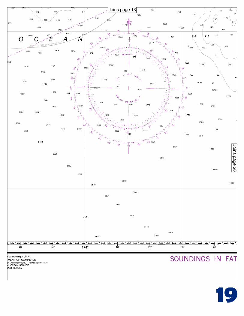
BookletChart ™ Near Islands – Buldir Island to Attu Island NOAA Chart 16420 A reduced-scale NOAA nautical chart for small boaters When possible, use the full-size NOAA chart for navigation. Included Area
-
Upload
vuongxuyen -
Category
Documents
-
view
226 -
download
0
Transcript of Near Islands Buldir Island to Attu Island - Quick Links · Near Islands Buldir Island to Attu...
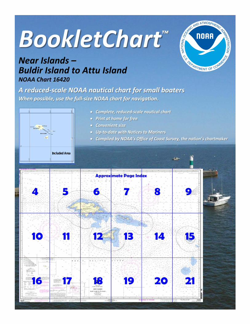
BookletChart™ Near Islands – Buldir Island to Attu Island NOAA Chart 16420
A reduced-scale NOAA nautical chart for small boaters When possible, use the full-size NOAA chart for navigation.
Included Area
2
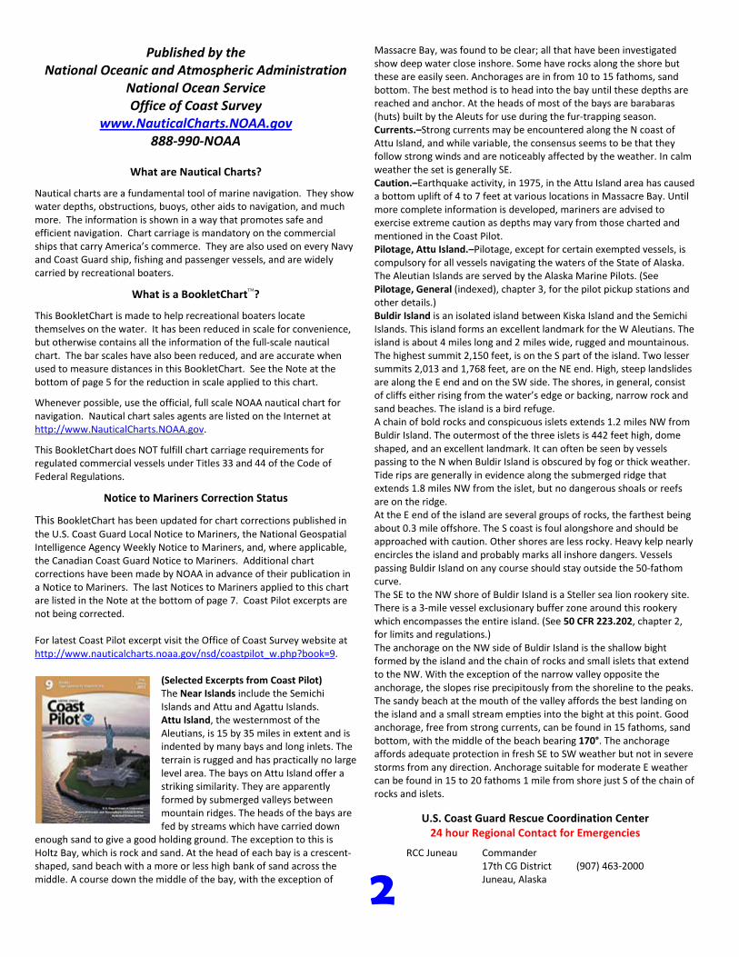
Published by the National Oceanic and Atmospheric Administration
National Ocean Service Office of Coast Survey
www.NauticalCharts.NOAA.gov 888-990-NOAA
What are Nautical Charts?
Nautical charts are a fundamental tool of marine navigation. They show water depths, obstructions, buoys, other aids to navigation, and much more. The information is shown in a way that promotes safe and efficient navigation. Chart carriage is mandatory on the commercial ships that carry America’s commerce. They are also used on every Navy and Coast Guard ship, fishing and passenger vessels, and are widely carried by recreational boaters.
What is a BookletChart?
This BookletChart is made to help recreational boaters locate themselves on the water. It has been reduced in scale for convenience, but otherwise contains all the information of the full-scale nautical chart. The bar scales have also been reduced, and are accurate when used to measure distances in this BookletChart. See the Note at the bottom of page 5 for the reduction in scale applied to this chart.
Whenever possible, use the official, full scale NOAA nautical chart for navigation. Nautical chart sales agents are listed on the Internet at http://www.NauticalCharts.NOAA.gov.
This BookletChart does NOT fulfill chart carriage requirements for regulated commercial vessels under Titles 33 and 44 of the Code of Federal Regulations.
Notice to Mariners Correction Status
This BookletChart has been updated for chart corrections published in the U.S. Coast Guard Local Notice to Mariners, the National Geospatial Intelligence Agency Weekly Notice to Mariners, and, where applicable, the Canadian Coast Guard Notice to Mariners. Additional chart corrections have been made by NOAA in advance of their publication in a Notice to Mariners. The last Notices to Mariners applied to this chart are listed in the Note at the bottom of page 7. Coast Pilot excerpts are not being corrected.
For latest Coast Pilot excerpt visit the Office of Coast Survey website at http://www.nauticalcharts.noaa.gov/nsd/coastpilot_w.php?book=9.
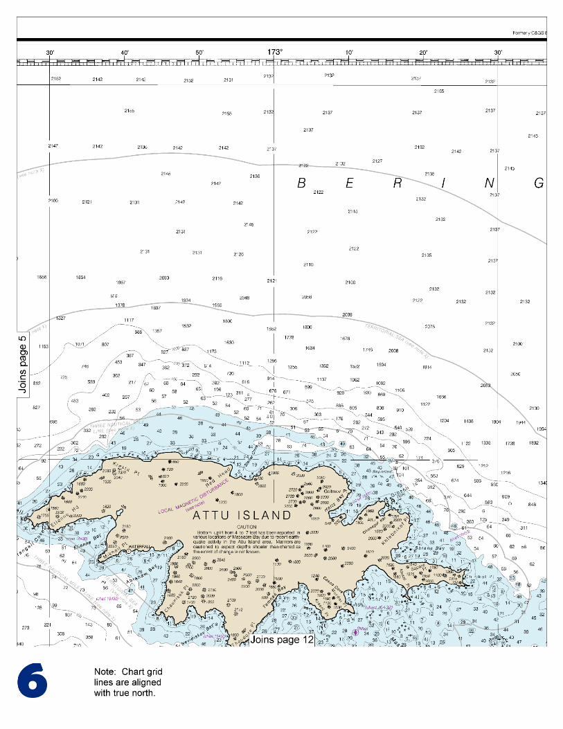
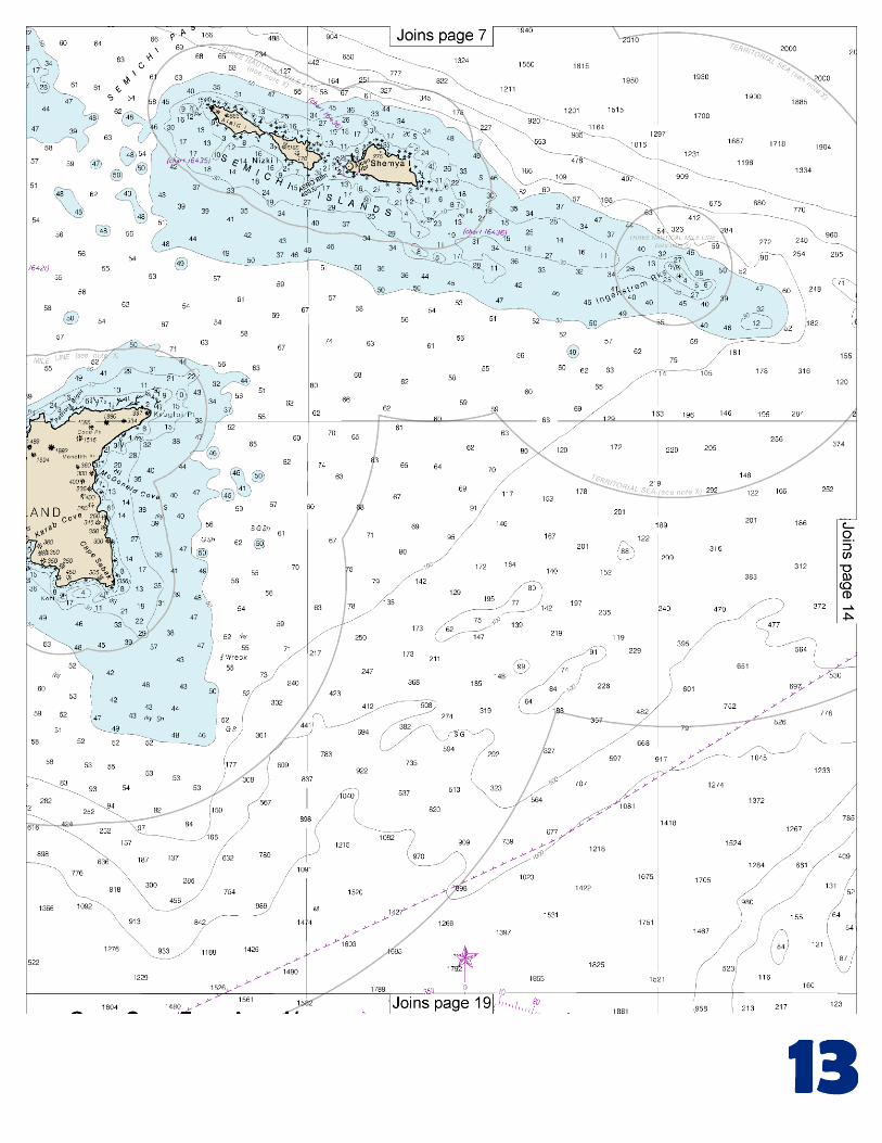
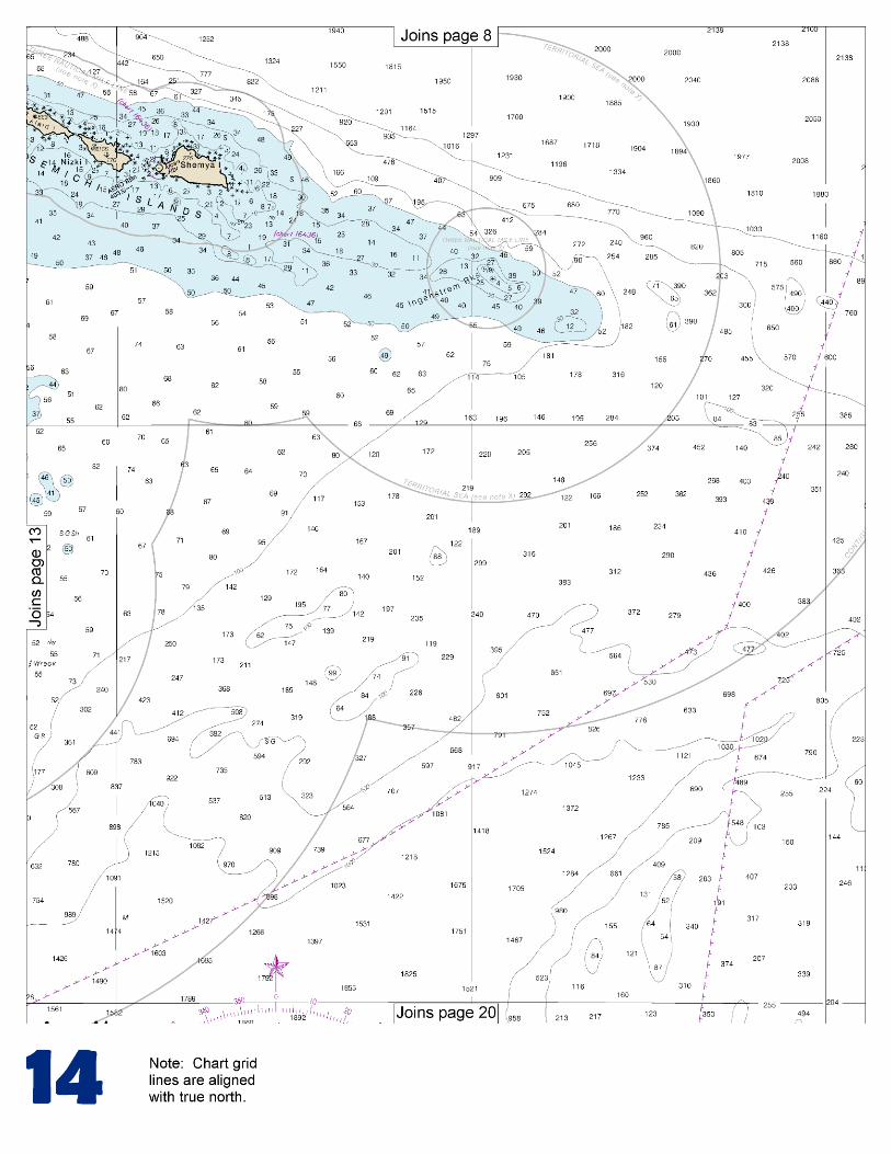
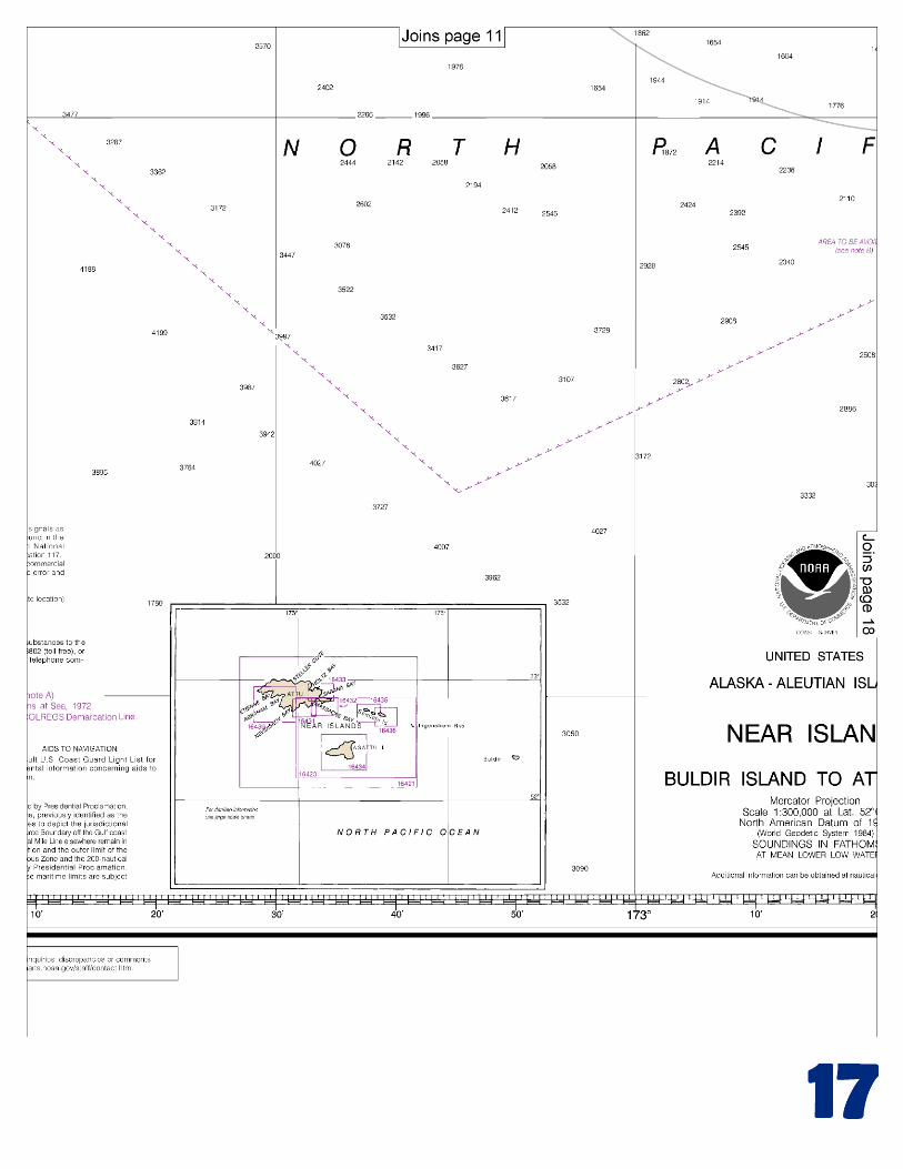
(Selected Excerpts from Coast Pilot) The Near Islands include the Semichi Islands and Attu and Agattu Islands. Attu Island, the westernmost of the Aleutians, is 15 by 35 miles in extent and is indented by many bays and long inlets. The terrain is rugged and has practically no large level area. The bays on Attu Island offer a striking similarity. They are apparently formed by submerged valleys between mountain ridges. The heads of the bays are fed by streams which have carried down
enough sand to give a good holding ground. The exception to this is Holtz Bay, which is rock and sand. At the head of each bay is a crescent-shaped, sand beach with a more or less high bank of sand across the middle. A course down the middle of the bay, with the exception of
Massacre Bay, was found to be clear; all that have been investigated show deep water close inshore. Some have rocks along the shore but these are easily seen. Anchorages are in from 10 to 15 fathoms, sand bottom. The best method is to head into the bay until these depths are reached and anchor. At the heads of most of the bays are barabaras (huts) built by the Aleuts for use during the fur-trapping season. Currents.–Strong currents may be encountered along the N coast of Attu Island, and while variable, the consensus seems to be that they follow strong winds and are noticeably affected by the weather. In calm weather the set is generally SE. Caution.–Earthquake activity, in 1975, in the Attu Island area has caused a bottom uplift of 4 to 7 feet at various locations in Massacre Bay. Until more complete information is developed, mariners are advised to exercise extreme caution as depths may vary from those charted and mentioned in the Coast Pilot. Pilotage, Attu Island.–Pilotage, except for certain exempted vessels, is compulsory for all vessels navigating the waters of the State of Alaska. The Aleutian Islands are served by the Alaska Marine Pilots. (See Pilotage, General (indexed), chapter 3, for the pilot pickup stations and other details.) Buldir Island is an isolated island between Kiska Island and the Semichi Islands. This island forms an excellent landmark for the W Aleutians. The island is about 4 miles long and 2 miles wide, rugged and mountainous. The highest summit 2,150 feet, is on the S part of the island. Two lesser summits 2,013 and 1,768 feet, are on the NE end. High, steep landslides are along the E end and on the SW side. The shores, in general, consist of cliffs either rising from the water’s edge or backing, narrow rock and sand beaches. The island is a bird refuge. A chain of bold rocks and conspicuous islets extends 1.2 miles NW from Buldir Island. The outermost of the three islets is 442 feet high, dome shaped, and an excellent landmark. It can often be seen by vessels passing to the N when Buldir Island is obscured by fog or thick weather. Tide rips are generally in evidence along the submerged ridge that extends 1.8 miles NW from the islet, but no dangerous shoals or reefs are on the ridge. At the E end of the island are several groups of rocks, the farthest being about 0.3 mile offshore. The S coast is foul alongshore and should be approached with caution. Other shores are less rocky. Heavy kelp nearly encircles the island and probably marks all inshore dangers. Vessels passing Buldir Island on any course should stay outside the 50-fathom curve. The SE to the NW shore of Buldir Island is a Steller sea lion rookery site. There is a 3-mile vessel exclusionary buffer zone around this rookery which encompasses the entire island. (See 50 CFR 223.202, chapter 2, for limits and regulations.) The anchorage on the NW side of Buldir Island is the shallow bight formed by the island and the chain of rocks and small islets that extend to the NW. With the exception of the narrow valley opposite the anchorage, the slopes rise precipitously from the shoreline to the peaks. The sandy beach at the mouth of the valley affords the best landing on the island and a small stream empties into the bight at this point. Good anchorage, free from strong currents, can be found in 15 fathoms, sand bottom, with the middle of the beach bearing 170°. The anchorage affords adequate protection in fresh SE to SW weather but not in severe storms from any direction. Anchorage suitable for moderate E weather can be found in 15 to 20 fathoms 1 mile from shore just S of the chain of rocks and islets.
U.S. Coast Guard Rescue Coordination Center 24 hour Regional Contact for Emergencies
RCC Juneau Commander 17th CG District (907) 463-2000 Juneau, Alaska
G
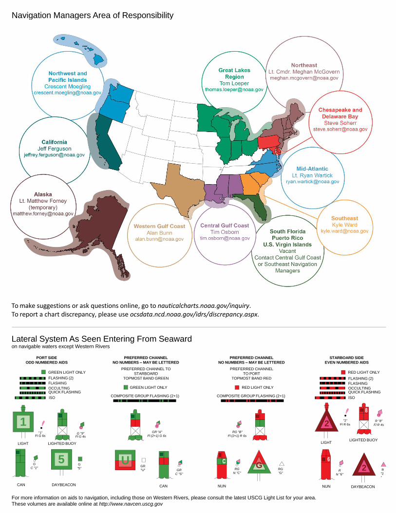
NOAA’s navigation managers serve as ambassadors to the maritime community. They help identify navigational challenges facing professional and recreational mariners, and provide NOAA resources and information for safe navigation. For additional information, please visit nauticalcharts.noaa.gov/service/navmanagers
To make suggestions or ask questions online, go to nauticalcharts.noaa.gov/inquiry. To report a chart discrepancy, please use ocsdata.ncd.noaa.gov/idrs/discrepancy.aspx.
Lateral System As Seen Entering From Seaward on navigable waters except Western Rivers
PORT SIDE
ODD NUMBERED AIDS
GREEN LIGHT ONLY
FLASHING (2)
PREFERRED CHANNEL
NO NUMBERS – MAY BE LETTERED
PREFERRED CHANNEL TO
STARBOARD
TOPMOST BAND GREEN
PREFERRED CHANNEL
NO NUMBERS – MAY BE LETTERED
PREFERRED CHANNEL
TO PORT
TOPMOST BAND RED
STARBOARD SIDE
EVEN NUMBERED AIDS
RED LIGHT ONLY
FLASHING (2)
FLASHING FLASHING
OCCULTING GREEN LIGHT ONLY RED LIGHT ONLY OCCULTING QUICK FLASHING QUICK FLASHING
ISO COMPOSITE GROUP FLASHING (2+1) COMPOSITE GROUP FLASHING (2+1) ISO
"1"
Fl G 6s
G "9"
Fl G 4s
GR "A"
Fl (2+1) G 6s
RG "B"
Fl (2+1) R 6s
"2"
Fl R 6s
8
R "8"
Fl R 4s
LIGHT
G
C "1"
LIGHTED BUOY
G
"5"
GR
"U"
GR
C "S"
RG
N "C"
RG
"G"
LIGHT
6
R
N "6"
LIGHTED BUOY
R
"2
"
CAN DAYBEACON
CAN NUN NUN
DAYBEACON
For more information on aids to navigation, including those on Western Rivers, please consult the latest USCG Light List for your area.
These volumes are available online at http://www.navcen.uscg.gov
Navigation Managers Area of Responsibility
Northeast
Lt. Meghan McGovern
Northwest and
Pacific Islands
Crescent Moegling
Great Lakes Region
Tom Loeper
Chesapeake and
Delaware Bay
Steve Soherr
California
Jeff Ferguson
[email protected] Mid-Atlantic
Lt. Ryan Wartick
Alaska
Lt. Timothy M. Smith
Western Gulf Coast
Alan Bunn
Central Gulf Coast
Tim Osborn
[email protected] South Florida
Puerto Rico
U.S. Virgin Islands
Michael Henderson
Southeast
Kyle Ward
2
2 C U 5
1


VHF Marine Radio channels for use on the waterways:Channel 6 – Inter-ship safety communications.Channel 9 – Communications between boats and ship-to-coast.Channel 13 – Navigation purposes at bridges, locks, and harbors.Channel 16 – Emergency, distress and safety calls to Coast Guard and others, and to initiate calls to other
vessels. Contact the other vessel, agree to another channel, and then switch.Channel 22A – Calls between the Coast Guard and the public. Severe weather warnings, hazards to navigation and safety warnings are broadcast here.Channels 68, 69, 71, 72 and 78A – Recreational boat channels.
Getting and Giving Help — Signal other boaters using visual distress signals (flares, orange flag, lights, arm signals); whistles; horns; and on your VHF radio. You are required by law to help boaters in trouble. Respond to distress signals, but do not endanger yourself.
EMERGENCY INFORMATION
Distress Call Procedures
• Make sure radio is on.• Select Channel 16.• Press/Hold the transmit button.• Clearly say: “MAYDAY, MAYDAY, MAYDAY.”• Also give: Vessel Name and/or Description;Position and/or Location; Nature of Emergency; Number of People on Board.• Release transmit button.• Wait for 10 seconds — If no responseRepeat MAYDAY call.
HAVE ALL PERSONS PUT ON LIFE JACKETS!
This Booklet chart has been designed for duplex printing (printed on front and back of one sheet). If a duplex option is not available on your printer, you may print each sheet and arrange them back-to-back to allow for the proper layout when viewing.
QR
Quick ReferencesNautical chart related products and information - http://www.nauticalcharts.noaa.gov
Interactive chart catalog - http://www.charts.noaa.gov/InteractiveCatalog/nrnc.shtmlReport a chart discrepancy - http://ocsdata.ncd.noaa.gov/idrs/discrepancy.aspx
Chart and chart related inquiries and comments - http://ocsdata.ncd.noaa.gov/idrs/inquiry.aspx?frompage=ContactUs
Chart updates (LNM and NM corrections) - http://www.nauticalcharts.noaa.gov/mcd/updates/LNM_NM.html
Coast Pilot online - http://www.nauticalcharts.noaa.gov/nsd/cpdownload.htm
Tides and Currents - http://tidesandcurrents.noaa.gov
Marine Forecasts - http://www.nws.noaa.gov/om/marine/home.htm
National Data Buoy Center - http://www.ndbc.noaa.gov/
NowCoast web portal for coastal conditions - http://www.nowcoast.noaa.gov/
National Weather Service - http://www.weather.gov/
National Hurrican Center - http://www.nhc.noaa.gov/
Pacific Tsunami Warning Center - http://ptwc.weather.gov/
Contact Us - http://www.nauticalcharts.noaa.gov/staff/contact.htm
NOAA’s Office of Coast Survey The Nation’s Chartmaker
For the latest news from Coast Survey, follow @NOAAcharts
NOAA Weather Radio All Hazards (NWR) is a nationwide network of radio stations broadcasting continuous weather information directly from the nearest National Weather Service office. NWR broadcasts official Weather Service warnings, watches, forecasts and other hazard information 24 hours a day, 7 days a week. http://www.nws.noaa.gov/nwr/