“Navigation Tools and Activities” - California Cadet ... · Two techniques are employed when...
123
California Cadet Corps Curriculum on Map Reading “Navigation Tools and Activities” 5/22/2017 LEADERS KNOW THE WAY
Transcript of “Navigation Tools and Activities” - California Cadet ... · Two techniques are employed when...

California Cadet CorpsCurriculum onMap Reading
“Navigation Tools and Activities”
5/22/2017
LEADERS KNOW THE WAY
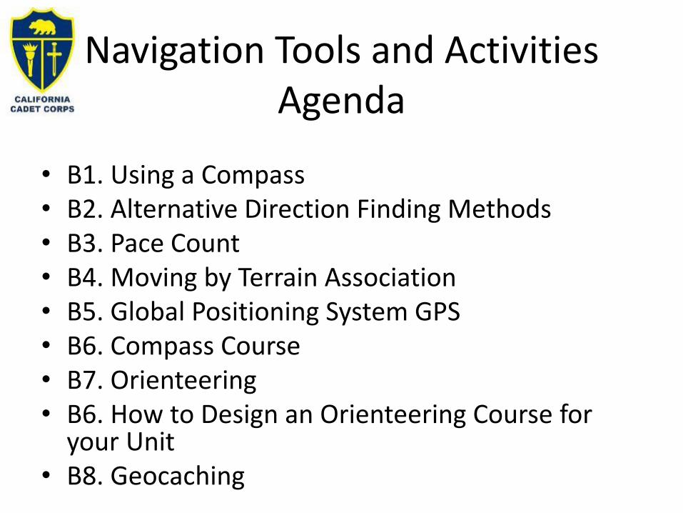
Navigation Tools and Activities Agenda
• B1. Using a Compass• B2. Alternative Direction Finding Methods• B3. Pace Count• B4. Moving by Terrain Association• B5. Global Positioning System GPS• B6. Compass Course• B7. Orienteering• B6. How to Design an Orienteering Course for
your Unit• B8. Geocaching

USING A COMPASS
B1. Use a lensatic compass to navigate a course.

Lensatic
CompassThe lensatic compass is
the most common and
simplest instrument for
measuring direction

Lensatic Compass
Parts of a compass
• Thumb Loop
• Cover
• Sighting Wire
• Eyepiece
• Sighting Slot
• Bezel Ring
• Index Line
• Compass Dial

Thumb Loop
Secures compass in closed position
Serves as wire loop to assist in sighting objects
Thumb Loop
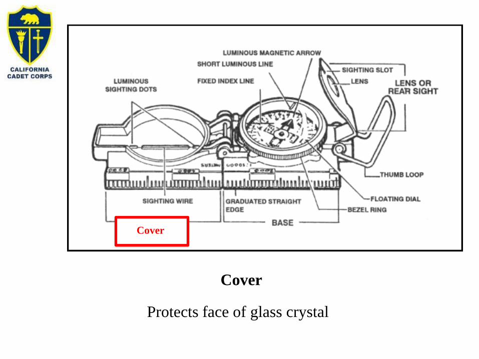
Cover
Protects face of glass crystal
Cover

Sighting Wire
Used to sight objects
Sighting
Wire

Eyepiece
Aids in sighting azimuths
Locks compass dial in place
Eyepiece
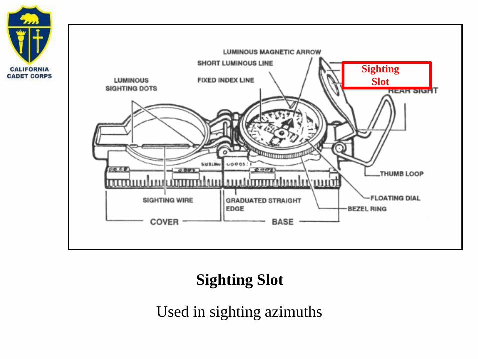
Sighting Slot
Used in sighting azimuths
Sighting
Slot

Bezel Ring
Used in pre-setting a direction in night compass work. Each
click represents three degrees
Bezel Ring

Index Line
Stationary black line used as a reference line
Index Line

Compass Dial
Indicates direction in mils and degrees
Compass Dial

Techniques of use
Two techniques are employed when using
the lensatic compass
• Center hold technique
• Compass to cheek technique

Center Hold Technique
Preferred method
Advantages
• It is faster and easier to use
• It can be used under all conditions of visibility
• It can be used over any type of terrain
• Accurate to within 11 degrees
• It can be used w/o removing eyeglasses
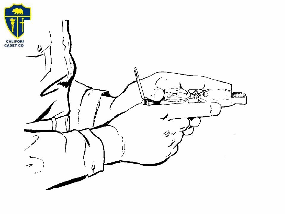

Note: If you have a metal belt buckle, use of this technique may induce error in the magnetic needle.

Compass to Cheek Technique
Advantages
• Works only with the Lensatic compass
• Accurate to within 3 degrees (much more
accurate than Center Hold Technique!)
• Used for Intersection and Resection

Fold the cover of the compass containing the sighting wire to a vertical position; then fold the rear sight slightly forward. Look through the rear-sight slot and align the frontsighthairline with the desired object in the distance. Then glance down at the dial through the eye lens to read the azimuth.
Compass to Cheek Technique

Presetting a compass
• Hold the compass level in the palm of the hand
• Rotate it until the desired azimuth falls under the fixed black
index line
• Turn the bezel ring until the luminous line is aligned with the
north seeking arrow. The compass is now preset
• Assume the centerhold technique and turn until the north
seeking arrow is aligned with the luminous line.
•Proceed in the direction of the sighting wire.

Presetting a Compass
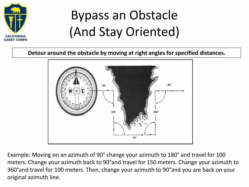
Bypass an Obstacle(And Stay Oriented)
Detour around the obstacle by moving at right angles for specified distances.
Example: Moving on an azimuth of 90° change your azimuth to 180° and travel for 100 meters. Change your azimuth back to 90°and travel for 150 meters. Change your azimuth to 360°and travel for 100 meters. Then, change your azimuth to 90°and you are back on your original azimuth line.

Offset
• A planned magnetic deviation to the right or left of an azimuth to an objective .• Use it when the objective is along a linear feature (road/stream)• Compensates for precision errors and ensures that upon reaching the linear feature, the
user knows whether to go right or left to reach the objective. • Ten degrees is an adequate offset for most uses.
Each degree offset moves the course about 18m to the right or left for each 1,000m traveled.
Note the image should indicate 180m offset, not 100m.
ALTERNATIVE DIRECTION FINDING METHODS
B2. Demonstrate how to find the four cardinal directions without a compass during cloudless daytime and nighttime hours.

Sunrise and Sunset
• It depends on latitude, and time of the year
• In general: – Face sunrise=East
– Face sunset=West
Q: It’s July and you’re walking into the setting sun. What’s your course?
A: 300°

Step 1: Place stick in ground and mark tip of shadow with stone.
Step 2: Wait 10-15 minutes and mark new position of shadow tip.
Step 3: Draw a straight line between the 2 marks .
Step 4: Stand with the first mark to your left, you are now facing
north
Shadow-Tip Method
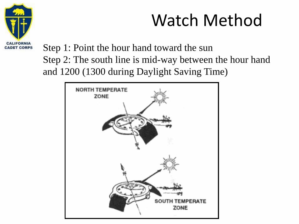
Step 1: Point the hour hand toward the sun
Step 2: The south line is mid-way between the hour hand
and 1200 (1300 during Daylight Saving Time)
Watch Method

North Star
•It is not the brightest star
•Less than 1 degree off of true north
•Use the pointers of the Big Dipper, 5 times the distance
•North star is the last star in the handle of the Little Dipper

PACE COUNT
B3. Determine your 100m pace count for flat ground, uphill, and downhill terrain.

Pace Count Intro
• It’s used to get a rough measurement of how far you’re walking.
• A pace count is the number of paces it takes you to walk a certain distance – usually 100 meters.
• Everyone’s pace count is unique – you have to measure your own.
• Your pace count will change with conditions

Pace Count Course
• To set up a course, use a measuring tool to measure 100 meters (not yards).
• Put a Start Line and a Stop Line that won’t get erased by stepping on it.
• The individual walks from the Start to Stop Line, counting every step or every other step
-100 meters-
Tip: Count only when your left (or right) foot hits the ground. You wont have to count as high!

Pace Count Calculation
• Don’t talk while you’re pacing, just count!
• Don’t take big or little steps. Just take steps that are normal to YOUR pace.
• When you reach the Stop point, note the number of paces it took you.
• Walk back to the Start Point, counting your paces again.
• Average your two counts.
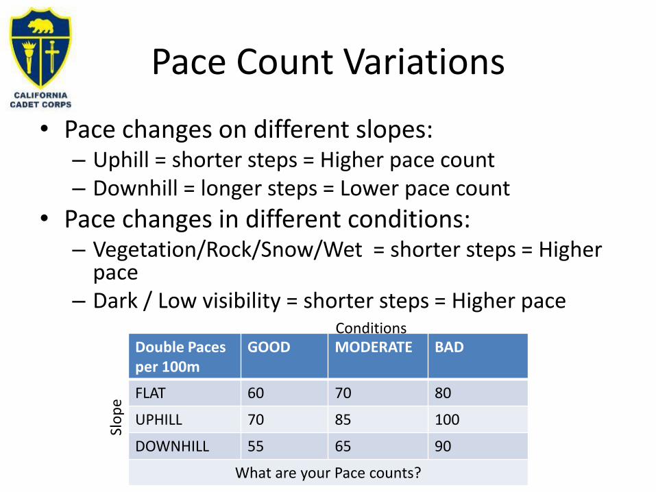
Pace Count Variations
• Pace changes on different slopes:– Uphill = shorter steps = Higher pace count– Downhill = longer steps = Lower pace count
• Pace changes in different conditions:– Vegetation/Rock/Snow/Wet = shorter steps = Higher
pace– Dark / Low visibility = shorter steps = Higher pace
Double Paces per 100m
GOOD MODERATE BAD
FLAT 60 70 80
UPHILL 70 85 100
DOWNHILL 55 65 90
What are your Pace counts?
Slo
pe
Conditions

Using Pace Count
• To measure distance while walking, start walking on your course and count your paces
• Every time you reach your pace count you’ve gone 100 meters.
– Make a note, tie a knot in a cord, put a pebble in your pocket, or move the 100m Ranger Bead.
• Start your count over and keep repeating until at your destination or at your total pace count

• Task: You have to walk 1.2 km west on a flat road• Background: Your flat pace count on easy terrain
is 60 paces (every other foot) and you’re using pebbles to keep track.
• Action– Place 12 pebbles in your right pocket, and start
walking west.– Count every right foot strike.– When you get to “60”, move a pebble to your left
pocket and start your count over at “1” and keep moving pebbles every time you count to “60”.
– When you move all 12 pebbles to your left pocket you’ve arrived at your destination
Pace Count Example 1

Pace Count Example 2
• Task: Your squad leader tells you to go recon the path you’re on 800 meters ahead and wait there for the squad to catch up. It’s a fairly steep uphill hike and it’s foggy.
• Background: Your uphill pace count in moderate conditions is 85 paces (every other foot) and you have a string in your pocket to tie knots in to keep track.
• Action– Start walking on the path– Count every right foot strike.– When you get to “85”, tie a knot in the string and start your
count over at “1” and keep tying knots every time you count to “60”.
– When you have 8 knots in your string you’ve arrived at your destination.

Pace Count Example 3
• Task: You are the Navigator for your adventure race team and you have to go 7.5km on a course of 172° over easy terrain. There are a series of uphills and downhills to traverse.
• Background: Your easy pace counts are uphill:70, downhill: 55, flat:60. You’re using ranger beads to keep track.
• Action– Start walking 172° and count every right foot strike.– If the next 100m is mostly
• Flat: Then use a pace count of 60 to move a 100-m bead• Uphill: Then use a pace count of 70 to move a 100-m bead• Downhill: Then use a pace count of 55 to move a 100-m bead
– After every 10 100-m beads, move a 1-km bead– When you’ve moved 7 1-km beads and 5 100-m beads you’ve arrived

Check on Learning
Calculate your Pace Count for as many of the conditions in this table as possible. Estimate the rest.
Double Paces per 100m
GOOD MODERATE BAD
FLAT
UPHILL
DOWNHILL
What are your Pace counts?

MOVING BY TERRAIN ASSOCIATION
B4. Given a map only, describe or demonstrate, how you would move from one point to another using terrain association.

Why Move by Terrain Association
• More forgiving of mistakes
• Far less time-consuming than dead reckoning
• It may be the only option if you do not have a compass– Or if you are off track (lost pace count or off course)
• Errors made using terrain association are easily corrected
• You can easily make adjustments based upon what you encounter.
• This is how you navigate to the neighborhood grocery store

How to Move by Terrain Association (1/3)
1. Determine your Starting Position– Estimate your location on the
map (If possible)– Identify key features on the map
you should be able to see• Terrain (hilltop, valley, ridge,
depression, and saddle)• Water (Lakes, rivers, streams,
ponds)• Man-Made (buildings, roads,
bridges, high-tension lines, towers, and fences)
– Look up to find feature matches (the more the better)
– Orient your map the same direction you’re facing
– Confirm your location on the map

How to Move by Terrain Association (2/3)
2. Determine your Destination (on the map)3. Create Checkpoints on your planned route that
take you to your destination.
Each chekpointshould have a prominent feature for you to confirm your arrival such as crossing a river, passing abeam a tower, etc.

How to Move by Terrain Association (3/3)
4. Start walkinga. Keep your map oriented in the direction of travelb. Walk to your first checkpoint, and then keep repeatingc. Confirm your position often, but always at checkpoints
Moving by terrain association must be practiced at every opportunity. There is no other way to learn or retain this skill.

Check on Learning
You want to travel from your position on Cerro Romualdo
to Whisky Spring but you have no compass or GPS. How would you do it?

One Possible Solution
1. Follow draw down hill (North) for 500 meters o Checkpoint: Rd Intx
2. Make 90° right and follow Road (East) for 1kmo Checkpoint: 1st Rd T past
Highway3. Make 90 ° left and follow path up
Guard Hill (north) for 1.2kmo Checkpoint: Peak w/ Tower
4. Parallel Fence line (north) 1km until paved road, turn right (east) 200mo Checkpoint: Dirt road T
intersection5. Follow dirt road 800m (north) until 90
bend, continue north to creek and follow upstream 1kmo Checkpoint: Abeam 429’ hill
with tower on right side6. Continue upstream 900m until spring
reachedo Checkpoint: Spring
1
2
3
4
5
6

GLOBAL POSITIONING SYSTEM (GPS)
B5. Identify the situations that are best suited for handheld GPS or cell-phone GPS.

Global Positioning System
• Constellation of 24 orbiting satellites that provides navigation data to military and civilian users all over the world.
• The system is operated and controlled by the 50th Space Wing, located at Schriever Air Force Base, Colo.
• GPS satellites orbit the earth every 12 hours, emitting continuous navigation signals.
• The signals are so accurate, time can be figured to within a millionth of a second, velocity within a fraction of a mile per hour and location to within 100 feet (or less).
• Receivers have been developed for use in aircraft, ships and land vehicles, as well as for hand carrying.
How Does GPS Work? (4m 50s sciBRIGHT video on Youtube)The Truth About GPS: How it works (3m 11s US Air Force Space Command Video on YouTube)

How to use a GPS
• On your phone: Install a navigational app (there are hundreds) and turn on location services. Most cell phones augment positions with Wi-Fi signals and internal gyroscopes. Use of your cellphone navigation system will likely require a cell phone signal and may not work in the field.

How to use a GPS
• On a handheld GPS: Turn on the GPS and wait for the system to acquire at least 4 satellites.
• You may need to step outside or out from under heavy tree canopy as these will block the satellite signal.
• Once your GPS receiver is “locked on” it will tell you your position usually in a latitude / longitude / elevation format along with a very accurate time.
• Most GPSs today display your position on loaded maps or even satellite imagery of the area.
• Handheld GPSs only require satellite signals to function and therefore work anywhere in the world.

Check on Learning
• Will your cell phone GPS work 5 miles out to sea?
• Will your cell phone GPS work inside Starbucks?
• Will a handheld GPS work indoors?
• How many satellites must a GPS receiver “see” to determine your location?

COMPASS COURSE
B6. Design or conduct a compass course at your school.
Compass Course
• Now that you’ve learned how to use a compass in the classroom, it’s time to go outside and spread out!
• This presentation will show you how to set up a simple compass course so you can practice your skills.

Compass Course
• You can easily set up a compass course for your Cadet Corps unit. This is a good project for senior cadets!
• You can either use a big open area like a football field or park, or an area with some buildings, like your school campus.

Bleachers Bleachers Bleachers
Bleachers Bleachers Bleachers
Baseball Field
Football Field
Basketball Courts
1 2 3
4
5
6 7
8
9
10
11
12
Sample Course
PE Snack Sales Building

Plan Your Course
• Determine your Start Point. It should be a point from which participants can move out in different directions.
• Look around and pick some points that are stationary objects, like the corner of a building or fence, the middle of bleachers on a football field, basketball courts, etc. Try not to make them right next to metal objects – you don’t want the point to mess with your compasses!

Organize Your PointsPoint Description
1 10’ in front of north center bleacher
2 10’ in front of north east bleacher
3 10’ in front of north west bleacher
4 10’ north of center south bleacher
5 SE corner of PE Snack building
6 Top of key on NW basket in basketball court
7 Top of key on NE basket in basketball court
8 Top of key on 3rd basket from NW in basketball court
9 Top of key on SE basket in basketball court
10 3rd base on baseball field
11 1st base on baseball field
12 10’ west of fencepost in centerfield, baseball field
SAM
PLE

Plan Your Course
Once you have points planned, develop routes between them – one for each participant or team
– i.e. Route Yellow goes from the Start Point to Point 2, then to 7, 6, and 11.
– The team going on Route Yellow (we’ll call them Team 1) gets the following directions:
➢Directions for Route Yellow:
➢Azimuth of 5° for 40m
➢Azimuth of 230° for 100m
➢Azimuth of 270° for 50m
➢Azimuth of 115° for 70m
➢Return to Start Point

Organize Your RoutesRoute 1st Point 2nd Point 3rd Point 4th Point
Yellow 2 7 6 11
Orange 1 9 12 10
Blue 3 1 8 7
Green 5 11 9 6
Black 7 8 11 12
Brown 4 5 9 10
Note: When plotting the routes, be mindful of obstacles – especially solid objects cadets can’t see through. You could theoretically put an obstacle like a chain link fence in the middle of a route to give a team a challenge to overcome, but make sure each route is equally challenged.
SAM
PLE

Plan Your Course
• Put a marker that has the Point Number on it at each point
• Measure the azimuth between each point pair that’s in a route. This is a good time to make sure the points work (i.e. view to next point isn’t blocked by a building, unless it’s an advanced course for cadets with experience).
• You have to be very accurate when you plot the azimuths and get the distance between points – and so do the teams! It’s a good practice to have 2 or 3 planners separately check the azimuth and distance. If you can use a measuring tool to get the distance, it will be more accurate than determining it by pace count.

Plan Your Course
Azimuths between points:FROM TO AZIMUTH DISTANCE
SP 1 305° 95M
SP 2 5° 40M
SP 3 58° 100M
SP 4 77° 40M
SP 5 263° 250M
SP 6 252° 380M
SP 7 247° 300M
1 2 90° 90M
1 3 90° 195M
1 4 141° 130M
etc. etc. etc. etc.
Continue in this way until you have all possible routes plotted and double checked. If you’re not going between one point and another (i.e. not going from Point 4 to Points 6-12 because the bleachers are in the way), you don’t have to plot those.

Plan Your Course
• Your course doesn’t have to be spread out over a super large area
• The points need to be far enough apart that they shouldn’t be confused with each other
• The closer the points are to each other, the more challenging the course

Plan Your Course
• Do you write OPLANs at your unit? This might be a good one to write. Just don’t share the answers to the course with cadets who will be running it!
• Make sure you announce the Who, What, When, Where and Why to all participating cadets, including what they need to bring (pencil, water, etc.)
• Ensure you have the materials you need to operate the course: compasses, route cards, pencils, water, clipboard, etc.

Plan Your Course
Sample Training Schedule
TIME WHO WHAT WHERE NOTES
1400-1500 STAFF SET UP COURSE FOOTBALL FIELD UNIFORM: CLASS C
1500-1510 C/1LT JONES BRIEF CADETS CLASSROOM ISSUE COMPASSES
1515 TMS 1-6 START COURSE FOOTBALL FIELD
1530 TMS 7-12 START COURSE FOOTBALL FIELD
1600-1615 ALL DEBRIEF CLASSROOM COLLECT COMPASSES

Plan Your Course
Sample
Scoresheet
SAMPLE COMPASS COURSE SCORESHEET
TEAM # ROUTE: _________________
START TIME: ________
FINISH TIME: ________
AZIMUTH DISTANCE POINT # SCORE
SP to 1st Point ________ ________ ________ ________
1st Point to 2nd Point ________ ________ ________ ________
2nd Poitn to 3rd Point ________ ________ ________ ________
3rd Point to 4th Point ________ ________ ________ ________
Return to Start Point!
TOTAL SCORE ________

Get Ready to Execute
• Before you start the course, ensure each cadet knows their pace count
• You can have cadets do the course by themselves if they’re ready for it, or pair them together. Don’t let one cadet in a team do all the work!
• You may have to stagger your start times, depending on how many cadets/teams and how many routes you have

Running the Course
• When a team arrives at a point, they note the number on their instruction sheet
• If they miscalculated and went to the wrong point, they’ll put the wrong number down. This will continue to throw them off for the rest of the course.
• To score the team, verify the numbers in their route match your answer key (for Team 1, it would be 2-7-6-11)
Check on Learning
AAR your Compass Course activity.

ORIENTEERING
B7. Explain the sport of Orienteering and how it works.

• Introduction to Orienteering
• An Orienteering Course
• Orienteering Maps
• Basic Techniques
• How to get started
• Questions
Agenda

Navigate to a series of points (controls) shown on a specialized topo map, choosing routes - on or off trail -that will help you find all the controls and get to the finish. Orienteering uses mostly terrain association to navigate from point to point.
What is Orienteering all about?
Running Wild: Orienteering | The New York Times (3 min 21 sec YouTube Video)How to Orienteer by Howcast (1 Min 43 sec YouTube Video)

• Began in Scandinavia around 1900– Exercises in land navigation for the military
• Gradually spread throughout the world– Kjellstrom brothers (founders of Silva) exported Orienteering to
UK and USA– Silva Holds the Trademark for Orienteering
• Now practiced on six continents– World championships held every year– Millions of competitors each year
How did Orienteering develop?

• Kids• Learning to read maps• Through Scouts, building team work and earning merit
badge• Through School and through the Cadet Corps
• Families exploring a new (or familiar) park• Outdoors lovers looking for a change• Hikers looking to improve their navigational skills• Adventure Racers wanting to get a leg up on the competition• Seniors looking to stay healthy• Businesses looking for team building activities• Competitive Orienteers addicted to the challenge
Who Goes Orienteering?

The Course
The orienteering course consists of a start, a series of control markers, and a finish.
A participant is given a map, a control card, and a clue sheet.
The control card is used to note the start and finish time, and to verify that the orienteer has visited each of the control markers on the course.
The map is used to mark the start and finish locations, as well as the locations of each of the control markers.

Where are Orienteering Events Held?
• Forests
• State and Regional Parks
• City Parks
• Suburban neighborhoods
• School / University campuses

What am I looking for?
• Orange and white “Control”
• Clue-sheet (words or symbols) tells you exactly where the control is and the control number
• Number on the control confirms you are at the right one
• Use the punch on the punch card to prove you visited the site

Successful Orienteering
Success in orienteering requires a number of different skills.
The winner of the competition is the participant who completes the course in the shortest time, so running ability is beneficial.
The orienteer must be able to read the map, select an appropriate route from one control point to the next and successfully follow that route.

Successful Orienteering
Map reading and analysis skills are by far the most crucial. A successful orienteer will develop the ability to observe the terrain around them, look at the map and identify where they are.
They will develop the ability to determine the quickest route between points, as well as the navigational skills to traverse that route.

The Course
The clue sheet has clues describing the placement of each of the control markers -the type of geographical features at which the marker has been placed - and a “control code” which identifies the marker.

Sample Clue Sheet
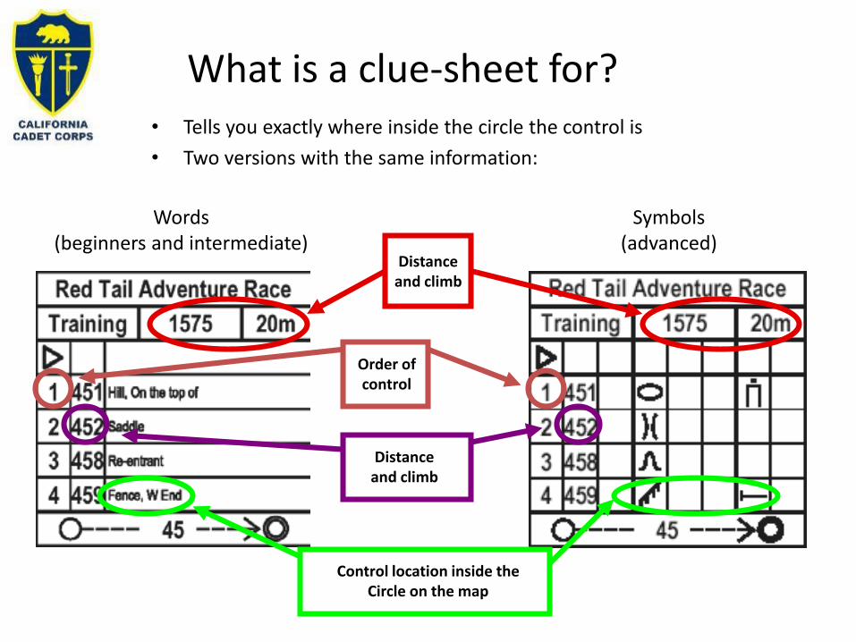
What is a clue-sheet for?• Tells you exactly where inside the circle the control is
• Two versions with the same information:
Words(beginners and intermediate)
Symbols(advanced)
Distanceand climb
Order ofcontrol
Distanceand climb
Control location inside theCircle on the map

What does the punch card look like?
Name: ______________Course: _____________Class: ______________License: ____________
Finish: ______:______
Start: ______:______
Time :
Name: ___________Course: __________Class: ___________License: _________
Finish: _____:_____
Start: _____:_____
Time :
Note: Some courses now use electronic methods for verifying controls, time, etc.

ExampleCourse
The Start is at the center of the triangle.
Controls are located at the center of each circle.
You complete controls in order.
The Finish is at the center of the double circle.
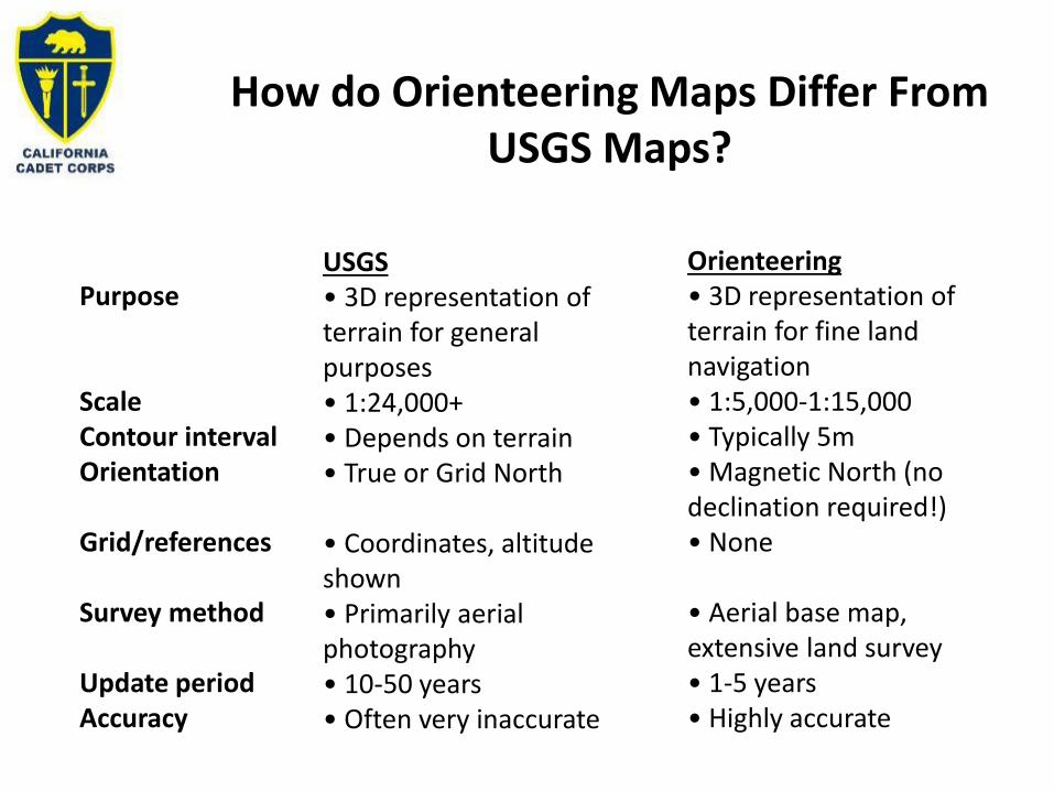
How do Orienteering Maps Differ FromUSGS Maps?
Grid/references
Survey method
Update periodAccuracy
USGS• 3D representation ofterrain for generalpurposes• 1:24,000+• Depends on terrain• True or Grid North
• Coordinates, altitudeshown• Primarily aerialphotography• 10-50 years• Often very inaccurate
Orienteering• 3D representation ofterrain for fine landnavigation• 1:5,000-1:15,000• Typically 5m• Magnetic North (nodeclination required!)• None
• Aerial base map,extensive land survey• 1-5 years• Highly accurate
Purpose
ScaleContour intervalOrientation

Orienteering MapLegend
• Man-made features primarily black• Rock features black• Contour features brown• Open areas yellow• Forest white, thickervegetation green
• Water blue• Courses and restricted areaspurple

Orienteering Skills / Strategies
• Orient the map using a compass• Visualize the terrain from the map• Recognize where you are on the map from the terrain• Plan your route and check off features• Taking a bearing (more advanced)• Aiming off (more advanced)• Attack point (more advanced)• Traffic lights (more advanced)• Pace counting (more advanced)

• An important strategy for successful orienteering is to orient your map. • This means that north on the map is kept physically turned towards north
in the real world.• Using your compass, rotate the map so north on the map is turned to north
on your compass. • By keeping your map oriented, you will reduce the tendency to become
disoriented yourself.
❖ Tip: Try to keep the map oriented all the time (need to turn the map as you change direction)
❖ Tip: Fold the map over so only the portion of the map you are interested in is visible
Orient your Map
Orienteering Skills / Strategies
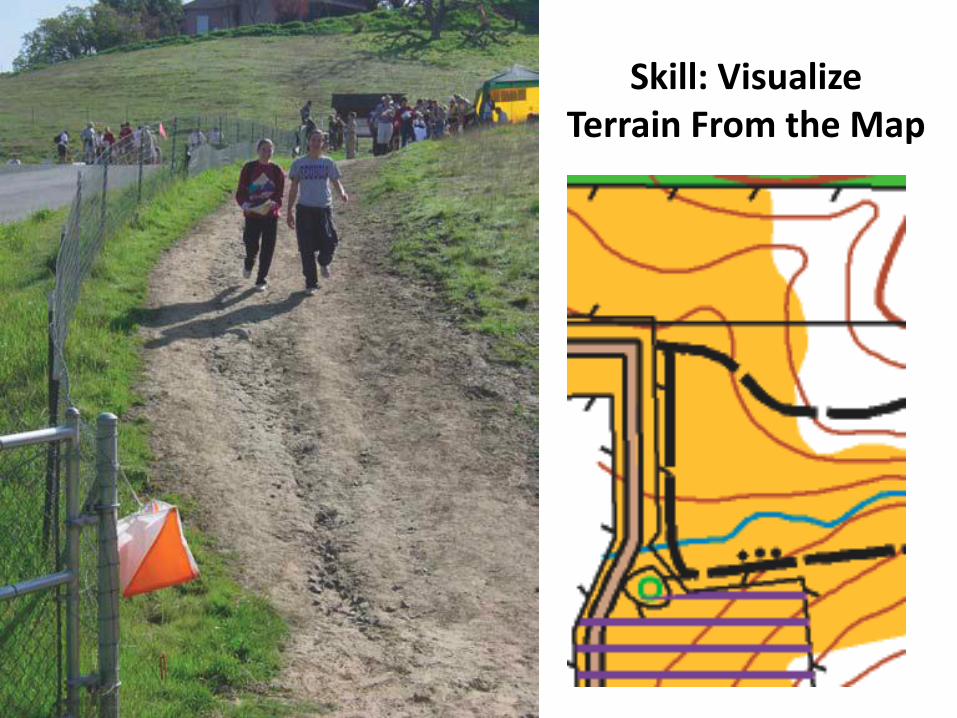
Skill: VisualizeTerrain From the Map

Skill: VisualizeTerrain From the Map

Skill: Recognize where you are on the map from the terrain

Orienteering Skills / Strategies
Use linear features as “handrails”. A handrail is any linear feature - like a trail, power line, stream, fence, or vegetation boundary - that you can “hang onto” or follow. As you plan your route, look for things you can follow.
Handrails

Orienteering Skills / Strategies
At the beginning these handrails will probably be trails or roads that are very easy to follow. As you begin doing intermediate level courses, start looking for streams, ridges or vegetation boundaries.
Handrails

Orienteering Skills / Strategies
Following a handrail may make your route slightly longer, but the advantage is that you are much less likely to become disoriented or lost.
Handrails

Some Advanced Techniques
Aiming Off – if taking a bearing to a line feature, ‘aim off’ to one side or the other so once you hit the line feature you know whether to turn left or right to find the point feature
Plan your route in reverse – identify an easily recognizable attack point to hit that you can use to ‘attack’ the harder to find control feature
Traffic-light approach– Go fast (green) when looking for large, easy to identify features (amajor trail junction
– Go steady (yellow) when looking for smaller, harder to identify features– Go slow (red) when looking for small, easily missed features
Pace counting – when the terrain is vague and you want to ensure you don’t go too far/stop too early

Advanced Techniques: Taking a Bearing
1. Lay compass on the map2. Line up the base-plate with direction you want to go in3. Turn the dial so the North marking on the dial is aligned with the North markings on the map4. Turn the compass so that the North needle is pointing in the same direction as the North marking on the dial. The direction on the base-plate is the direction of travel
• Tip: You only need to take bearings when there are no reliable mapped features to navigate by. Don’t overuse!

Orienteering Skills / Strategies
Often, on advanced courses, there are no true linear features to follow. In these instance, look for a series of features that more or less make a like in the direction you wish to travel. Break the route into several smaller ones.
Break it Up

Orienteering Skills / Strategies
Start at a dry stream
Break it Up

Orienteering Skills / Strategies
Pass a clearing
Break it Up

Orienteering Skills / Strategies
Follow the trail until it bends left
Break it Up

Orienteering Skills / Strategies
Pass a clearing
Break it Up

Orienteering Skills / Strategies
Pass a cluster of boulders
Break it Up

Orienteering Skills / Strategies
Pass another clearing
Break it Up

Orienteering Skills / Strategies
Follow the ridge past another boulder
Break it Up

Orienteering Skills / Strategies
Follow it until you find the control marker
Break it Up

What are the Different Colors of Courses?
• White – beginners courses, follow trails and otherlinear features. Good for first timers and kids age ~9-12. 1.5 – 3.0km
• Yellow – controls in less obvious locations, more off-trail.A great next step after successfully trying white course. 2-4km
• Orange – Intermediate controls that require cross-countrytravel. Can be quite challenging, physically and mentally.
• Brown, Green, Red, Blue – Advanced courses with themost demanding navigational requirements. NOTRECOMMENDED until some success with orange.Different lengths from Brown up to Blue (longest)

What should I wear?
Beginner (white/yellow)
• Sun hat• Layered top• Compass• Long or short pants• Sturdy shoes
What should I wear?
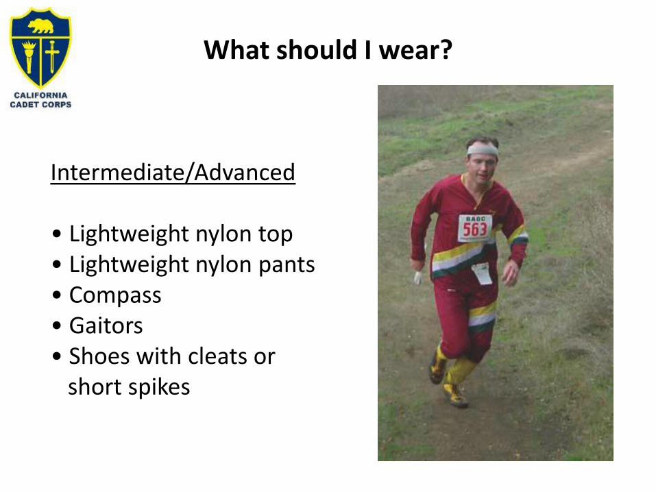
Intermediate/Advanced
• Lightweight nylon top• Lightweight nylon pants• Compass• Gaitors• Shoes with cleats or
short spikes

Does Orienteering Damage the Land?
• Orienteers go off trail, raising environmental concerns• We care deeply about the parks we use• Actual environmental impact is very low and short-lived
– Not using pristine wilderness areas– Work with park rangers to avoid sensitive areas– Courses visit different controls – dispersed impact– Affected areas recover within weeks at worst– Low impact confirmed by scientific studies
• Orienteering builds a tremendous love and respect forour environment

What About Safety?
✓ ALWAYS REPORT TO THE FINISH whether you complete your course or not
✓ ALWAYS RETURN TO THE FINISH BEFORE THE✓ COURSE CLOSING TIME whether you
complete your course or not✓ Carry a whistle✓ Know your limits (physical and navigational)
and stay within them✓ Take precautions if allergic to poison oak, bee
stings, etc.
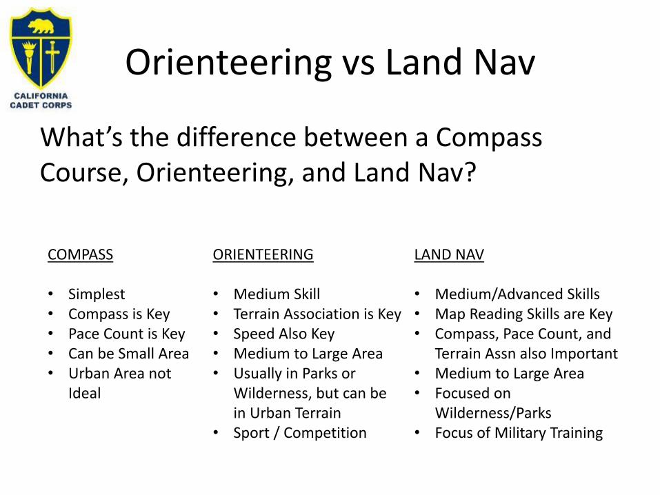
Orienteering vs Land Nav
What’s the difference between a Compass Course, Orienteering, and Land Nav?
COMPASS
• Simplest• Compass is Key• Pace Count is Key• Can be Small Area• Urban Area not
Ideal
ORIENTEERING
• Medium Skill• Terrain Association is Key• Speed Also Key• Medium to Large Area• Usually in Parks or
Wilderness, but can be in Urban Terrain
• Sport / Competition
LAND NAV
• Medium/Advanced Skills• Map Reading Skills are Key• Compass, Pace Count, and
Terrain Assn also Important• Medium to Large Area• Focused on
Wilderness/Parks• Focus of Military Training
Check on Learning
1. While running an Orienteering course how is the map oriented?
2. What technique is used when you follow a fenceline, river, or other linear feature?
3. Who can participate in orienteering?
4. What is the orange/white target that you are navigating to called?

DESIGNING AN ORIENTEERING COURSE FOR YOUR CACC UNIT
B8. Find or design an orienteering course for your battalion.

Orienteering Clubs
• You may not need to design your own course
• Check in your area to see if there’s an Orienteering Club or established courses you could use
• If not, don’t despair – design your own!
Bay Area Orienteering Club (BAOC)http://baoc.org/wiki/WelcomeMenlo Park, California 94025
Gold Country Orienteers (GCO)http://www.goldcountryorienteers.org/Lincoln, California 95648
Los Angeles Orienteering Club (LAOC)http://losangelesorienteering.org/drupal/Manhattan Beach, California 90266
Nav-X Map Adventures (NAVX)http://www.navxchallenge.org/Folsom, California 95630
San Diego Orienteering (SDO)http://www.sandiegoorienteering.orgSan Diego, California 92111-4020
TerraLoco (Supporting Member) (LOCO)http://terraloco.comOakland, California 94612
Truckee Orienteering Club (Truckee)http://www.truckeeorienteering.orgTruckee, California 96161

Orienteering Course
• Take a look at the slides in the Orienteering presentation
• Determine a location. Local/County or State Park nearby? Bivouac site?
• Get a map. Go on line!• Plot key terrain features as your points• Get the free program to develop Clue Sheets on
line• Build your Control markers• Design a scorecard that works for your course

Orienteering
• Write a simple OPLAN using CR 3-13
• Who – What – When – Where – Why
– Our Bn is running an Orienteering Course at X Park on (date) to practice map skills and have fun.
• Get school authorization
• Invite other students and teachers!
• Come up with rewards for winners (maybe a local veterans organization could sponsor this)
GEOCAHING
B9. Find the nearest geo-cashes to your school or bivouac.

What is Geocaching
• Geocaching Overview: https://www.geocaching.com/play
• Geocaching in California: https://www.geocaching.com/local/default.aspx?state_id=5
Geocaching
International Geocaching Logo
Nicknames Caching, Treasure Hunting
First played May 3, 2000
Clubs Yes
Characteristics
Team members Optional
Type Outdoor Recreation Activity
Equipment
GPS receiver or GPS-enabled
mobile device, writing
implement
Overview
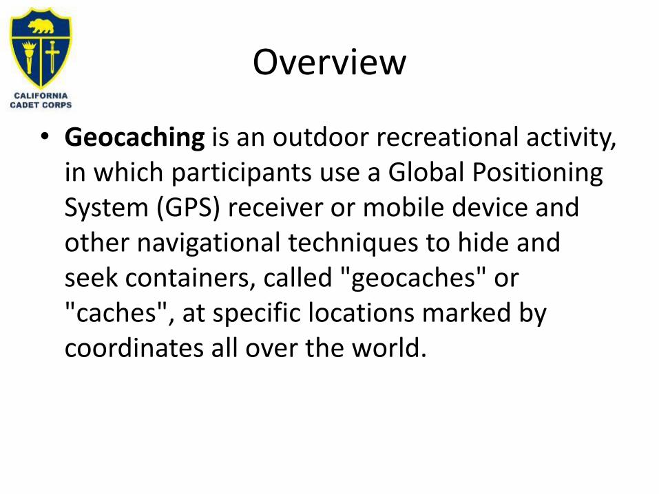
• Geocaching is an outdoor recreational activity, in which participants use a Global Positioning System (GPS) receiver or mobile device and other navigational techniques to hide and seek containers, called "geocaches" or "caches", at specific locations marked by coordinates all over the world.

The Cache
• Small waterproof container containing a logbook.
• The geocacher enters the date they found it and signs it.
• The cache must be placed back exactly where the person found it.
• Larger containers can also contain items for trading, such as toys or trinkets, usually of more sentimental worth than financial.

Geocaching History
• It began shortly after the removal of Selective Availability from the Global Positioning System on May 2, 2000. – Improved accuracy of the system
allowed for a small container to be located.
• The first documented placement of a cache took place on May 3, 2000, by Dave Ulmer of Beavercreek, Oregon. – Location: 45°17.460′N 122°24.800′W.
• According to Dave Ulmer's message, this cache was a bucket that was partially buried and contained software, videos, books, food, money, and a slingshot.
• A geocache and plaque called the Original Stash Tribute Plaque now sit at that site.
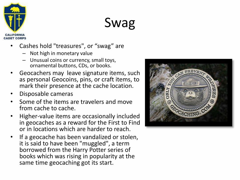
Swag
• Cashes hold "treasures", or “swag” are – Not high in monetary value – Unusual coins or currency, small toys,
ornamental buttons, CDs, or books.
• Geocachers may leave signature items, such as personal Geocoins, pins, or craft items, to mark their presence at the cache location.
• Disposable cameras • Some of the items are travelers and move
from cache to cache.• Higher-value items are occasionally included
in geocaches as a reward for the First to Find or in locations which are harder to reach.
• If a geocache has been vandalized or stolen, it is said to have been "muggled", a term borrowed from the Harry Potter series of books which was rising in popularity at the same time geocaching got its start.

Navigation Tools and Activities Summary
• B1. Using a Compass• B2. Alternative Direction Finding Methods• B3. Pace Count• B4. Moving by Terrain Association• B5. Global Positioning System GPS• B6. Compass Course• B7. Orienteering• B6. How to Design an Orienteering Course for
your Unit• B8. Geocaching