Navigating beyond sight of landsplashmaritime.com.au/Marops/data/text/Navtex/Beyon… · ·...
26
1 Navigating beyond sight of land Ranger Hope © 2016 Contents Introduction Terrestrial position Celestial position The Sailings Azimuth or Amplitude Position without a chart Answers Compass checks Answers Traverse Introduction Traditional coastal navigation begins from a known point or a fix from land based features plotted on a suitable chart. During the passage, course steered from the ships compass and speed from the ships log provides dead reckoning plots of the ships progress, confirmed by additional fixes en route. Whenever the opportunity arises a confirmation of continuing compass accuracy is checked by land based transits. When on passage out of sight of land the navigator relies on the continuing accuracy of the dead reckoning or GPS for notifying of change in position. If she experiences compass error she is none the wiser and if she experiences power failure navigation position is lost. However, two basic computational processes using Nautical (navigational tables) are available. The first is to compare the predicted bearing of the sun at rising or setting with the observed compass reading (using azimuths or amplitudes tables) and the second to determine the changes in position without plotting on a chart (by traverse tables). In order to use the tabulated data an underpinning knowledge of terrestrial and celestial navigational definitions is required.
Transcript of Navigating beyond sight of landsplashmaritime.com.au/Marops/data/text/Navtex/Beyon… · ·...
1
Navigating beyond sight of land Ranger Hope © 2016
Contents
Introduction Terrestrial position Celestial position The Sailings Azimuth or Amplitude Position without a chart Answers Compass checks Answers Traverse
Introduction
Traditional coastal navigation begins from a known point or a fix from land based features plotted on a suitable chart. During the passage, course steered from the ships compass and speed from the ships log provides dead reckoning plots of the ships progress, confirmed by additional fixes en route. Whenever the opportunity arises a confirmation of continuing compass accuracy is checked by land based transits. When on passage out of sight of land the navigator relies on the continuing accuracy of the dead reckoning or GPS for notifying of change in position. If she experiences compass error she is none the wiser and if she experiences power failure navigation position is lost. However, two basic computational processes using Nautical (navigational tables) are available. The first is to compare the predicted bearing of the sun at rising or setting with the observed compass reading (using azimuths or amplitudes tables) and the second to determine the changes in position without plotting on a chart (by traverse tables). In order to use the tabulated data an underpinning knowledge of terrestrial and celestial navigational definitions is required.
2
Terrestrial position
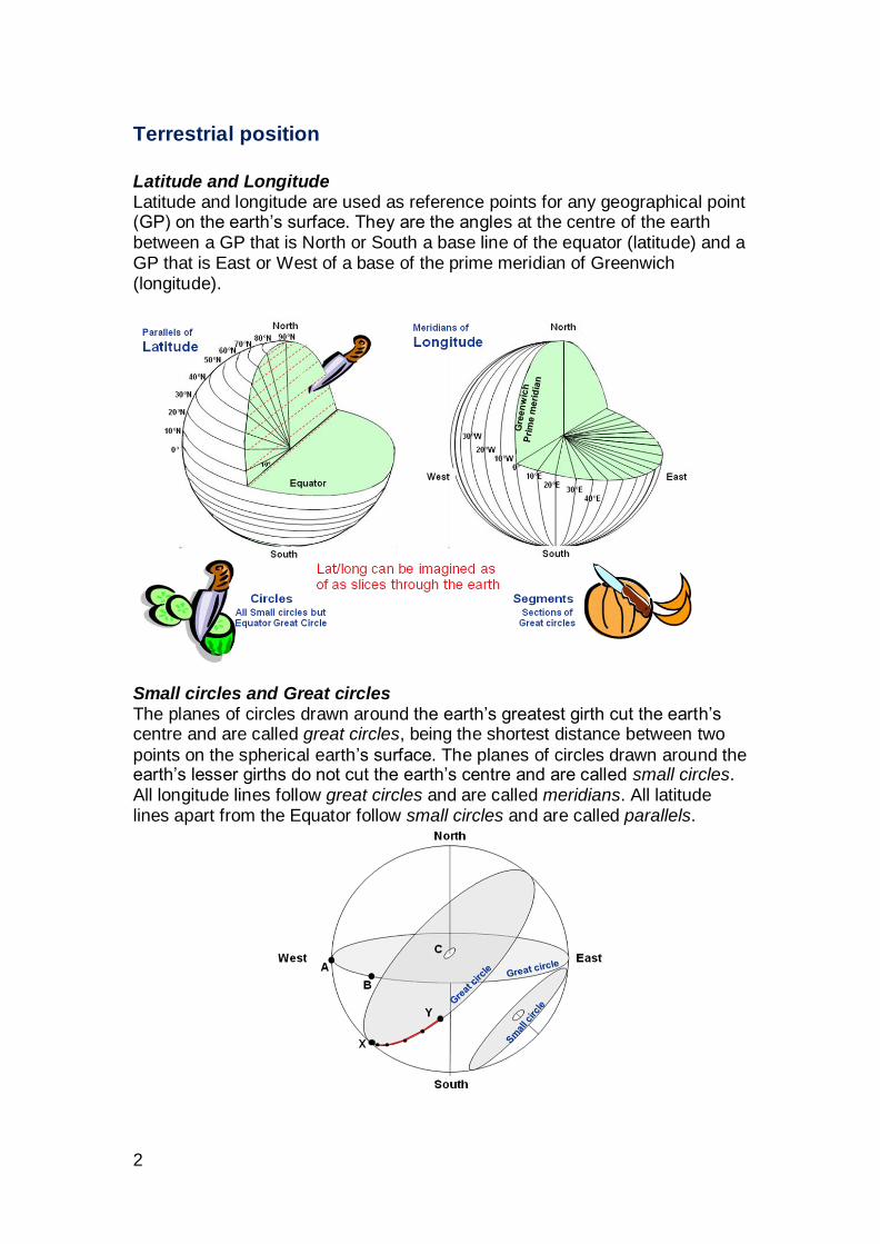
Latitude and Longitude Latitude and longitude are used as reference points for any geographical point (GP) on the earth’s surface. They are the angles at the centre of the earth between a GP that is North or South a base line of the equator (latitude) and a GP that is East or West of a base of the prime meridian of Greenwich (longitude).
Small circles and Great circles The planes of circles drawn around the earth’s greatest girth cut the earth’s centre and are called great circles, being the shortest distance between two
points on the spherical earth’s surface. The planes of circles drawn around the earth’s lesser girths do not cut the earth’s centre and are called small circles. All longitude lines follow great circles and are called meridians. All latitude lines apart from the Equator follow small circles and are called parallels.
3
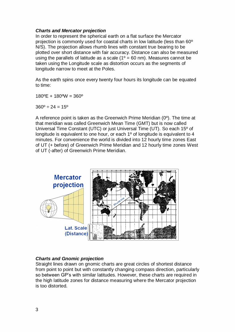
Charts and Mercator projection In order to represent the spherical earth on a flat surface the Mercator projection is commonly used for coastal charts in low latitude (less than 60º N/S). The projection allows rhumb lines with constant true bearing to be plotted over short distance with fair accuracy. Distance can also be measured using the parallels of latitude as a scale (1º = 60 nm). Measures cannot be taken using the Longitude scale as distortion occurs as the segments of longitude narrow to meet at the Poles. As the earth spins once every twenty four hours its longitude can be equated to time: 180ºE + 180ºW = 360º 360º ÷ 24 = 15º A reference point is taken as the Greenwich Prime Meridian (0º). The time at that meridian was called Greenwich Mean Time (GMT) but is now called Universal Time Constant (UTC) or just Universal Time (UT). So each 15º of longitude is equivalent to one hour, or each 1º of longitude is equivalent to 4 minutes. For convenience the world is divided into 12 hourly time zones East of UT (+ before) of Greenwich Prime Meridian and 12 hourly time zones West of UT (-after) of Greenwich Prime Meridian.
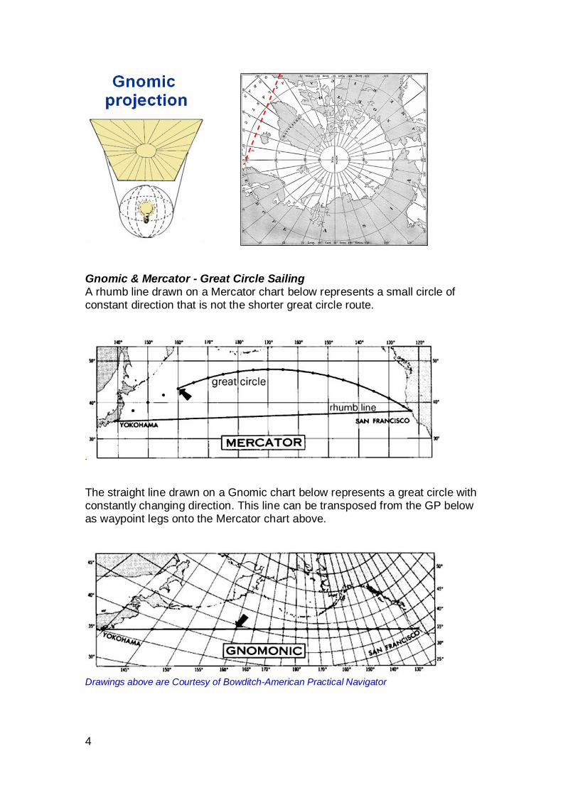
Charts and Gnomic projection Straight lines drawn on gnomic charts are great circles of shortest distance from point to point but with constantly changing compass direction, particularly so between GP’s with similar latitudes. However, these charts are required in the high latitude zones for distance measuring where the Mercator projection is too distorted.
4
Gnomic & Mercator - Great Circle Sailing A rhumb line drawn on a Mercator chart below represents a small circle of constant direction that is not the shorter great circle route.
The straight line drawn on a Gnomic chart below represents a great circle with constantly changing direction. This line can be transposed from the GP below as waypoint legs onto the Mercator chart above.
Drawings above are Courtesy of Bowditch-American Practical Navigator
5
Celestial position
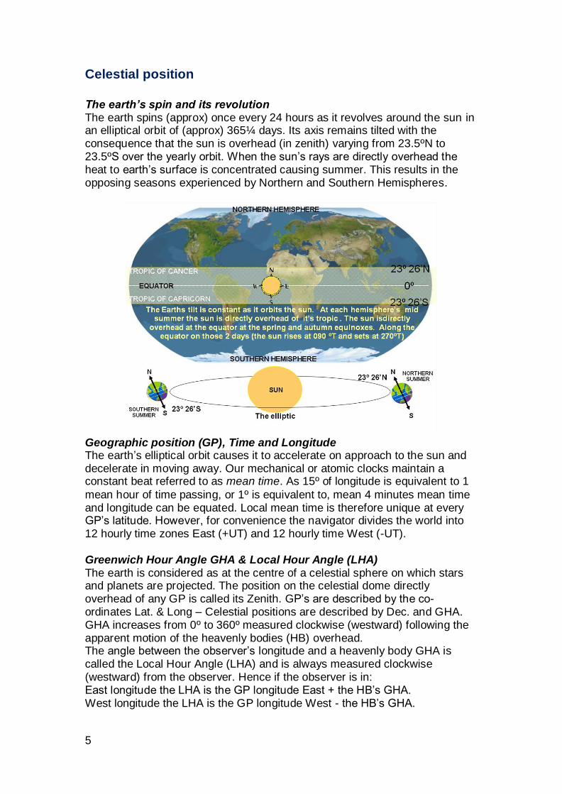
The earth’s spin and its revolution The earth spins (approx) once every 24 hours as it revolves around the sun in an elliptical orbit of (approx) 365¼ days. Its axis remains tilted with the consequence that the sun is overhead (in zenith) varying from 23.5ºN to 23.5ºS over the yearly orbit. When the sun’s rays are directly overhead the heat to earth’s surface is concentrated causing summer. This results in the opposing seasons experienced by Northern and Southern Hemispheres.
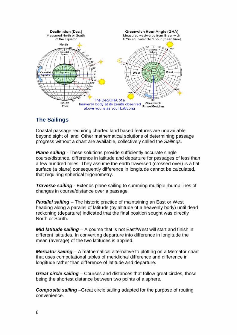
Geographic position (GP), Time and Longitude The earth’s elliptical orbit causes it to accelerate on approach to the sun and decelerate in moving away. Our mechanical or atomic clocks maintain a constant beat referred to as mean time. As 15º of longitude is equivalent to 1
mean hour of time passing, or 1º is equivalent to, mean 4 minutes mean time and longitude can be equated. Local mean time is therefore unique at every GP’s latitude. However, for convenience the navigator divides the world into 12 hourly time zones East (+UT) and 12 hourly time West (-UT). Greenwich Hour Angle GHA & Local Hour Angle (LHA) The earth is considered as at the centre of a celestial sphere on which stars and planets are projected. The position on the celestial dome directly overhead of any GP is called its Zenith. GP’s are described by the co-ordinates Lat. & Long – Celestial positions are described by Dec. and GHA. GHA increases from 0º to 360º measured clockwise (westward) following the apparent motion of the heavenly bodies (HB) overhead. The angle between the observer’s longitude and a heavenly body GHA is called the Local Hour Angle (LHA) and is always measured clockwise (westward) from the observer. Hence if the observer is in: East longitude the LHA is the GP longitude East + the HB’s GHA. West longitude the LHA is the GP longitude West - the HB’s GHA.
6
The Sailings
Coastal passage requiring charted land based features are unavailable beyond sight of land. Other mathematical solutions of determining passage progress without a chart are available, collectively called the Sailings. Plane sailing - These solutions provide sufficiently accurate single course/distance, difference in latitude and departure for passages of less than a few hundred miles. They assume the earth traversed (crossed over) is a flat surface (a plane) consequently difference in longitude cannot be calculated, that requiring spherical trigonometry. Traverse sailing - Extends plane sailing to summing multiple rhumb lines of changes in course/distance over a passage. Parallel sailing – The historic practice of maintaining an East or West heading along a parallel of latitude (by altitude of a heavenly body) until dead reckoning (departure) indicated that the final position sought was directly North or South. Mid latitude sailing – A course that is not East/West will start and finish in different latitudes. In converting departure into difference in longitude the mean (average) of the two latitudes is applied. Mercator sailing – A mathematical alternative to plotting on a Mercator chart that uses computational tables of meridional difference and difference in longitude rather than difference of latitude and departure. Great circle sailing – Courses and distances that follow great circles, those being the shortest distance between two points of a sphere. Composite sailing –Great circle sailing adapted for the purpose of routing convenience.
7
Azimuth or Amplitude
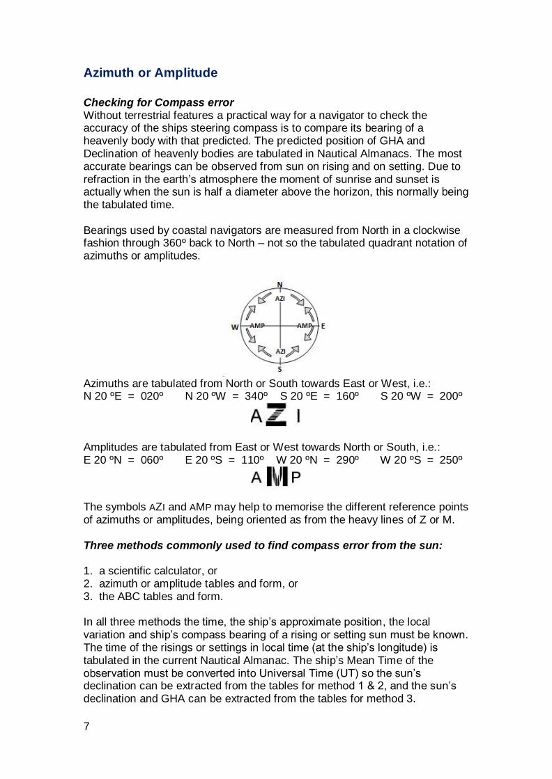
Checking for Compass error Without terrestrial features a practical way for a navigator to check the accuracy of the ships steering compass is to compare its bearing of a heavenly body with that predicted. The predicted position of GHA and Declination of heavenly bodies are tabulated in Nautical Almanacs. The most accurate bearings can be observed from sun on rising and on setting. Due to refraction in the earth’s atmosphere the moment of sunrise and sunset is actually when the sun is half a diameter above the horizon, this normally being the tabulated time. Bearings used by coastal navigators are measured from North in a clockwise fashion through 360º back to North – not so the tabulated quadrant notation of azimuths or amplitudes.
Azimuths are tabulated from North or South towards East or West, i.e.: N 20 ºE = 020º N 20 ºW = 340º S 20 ºE = 160º S 20 ºW = 200º
Amplitudes are tabulated from East or West towards North or South, i.e.: E 20 ºN = 060º E 20 ºS = 110º W 20 ºN = 290º W 20 ºS = 250º
The symbols AZI and AMP may help to memorise the different reference points of azimuths or amplitudes, being oriented as from the heavy lines of Z or M. Three methods commonly used to find compass error from the sun: 1. a scientific calculator, or 2. azimuth or amplitude tables and form, or 3. the ABC tables and form. In all three methods the time, the ship’s approximate position, the local variation and ship’s compass bearing of a rising or setting sun must be known. The time of the risings or settings in local time (at the ship’s longitude) is tabulated in the current Nautical Almanac. The ship’s Mean Time of the observation must be converted into Universal Time (UT) so the sun’s declination can be extracted from the tables for method 1 & 2, and the sun’s declination and GHA can be extracted from the tables for method 3.
8
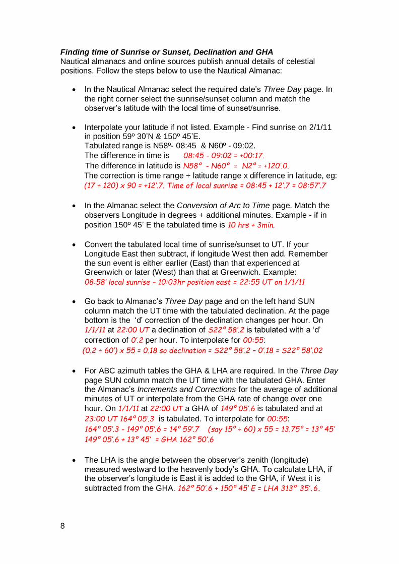
Finding time of Sunrise or Sunset, Declination and GHA Nautical almanacs and online sources publish annual details of celestial positions. Follow the steps below to use the Nautical Almanac:
In the Nautical Almanac select the required date’s Three Day page. In
the right corner select the sunrise/sunset column and match the observer’s latitude with the local time of sunset/sunrise.
Interpolate your latitude if not listed. Example - Find sunrise on 2/1/11 in position 59º 30’N & 150º 45’E. Tabulated range is N58º- 08:45 & N60º - 09:02.
The difference in time is 08:45 - 09:02 = +00:17.
The difference in latitude is N58º - N60º = N2º = +120’.0.
The correction is time range ÷ latitude range x difference in latitude, eg:
(17 ÷ 120) x 90 = +12’.7. Time of local sunrise = 08:45 + 12’.7 = 08:57’.7
In the Almanac select the Conversion of Arc to Time page. Match the
observers Longitude in degrees + additional minutes. Example - if in
position 150º 45’ E the tabulated time is 10 hrs + 3min.
Convert the tabulated local time of sunrise/sunset to UT. If your Longitude East then subtract, if longitude West then add. Remember the sun event is either earlier (East) than that experienced at Greenwich or later (West) than that at Greenwich. Example:
08:58’ local sunrise – 10:03hr position east = 22:55 UT on 1/1/11
Go back to Almanac’s Three Day page and on the left hand SUN
column match the UT time with the tabulated declination. At the page bottom is the ‘d’ correction of the declination changes per hour. On
1/1/11 at 22:00 UT a declination of S22º 58’.2 is tabulated with a ‘d’
correction of 0’.2 per hour. To interpolate for 00:55:
(0.2 ÷ 60’) x 55 = 0.18 so declination = S22º 58’.2 – 0’.18 = S22º 58’.02
For ABC azimuth tables the GHA & LHA are required. In the Three Day
page SUN column match the UT time with the tabulated GHA. Enter the Almanac’s Increments and Corrections for the average of additional minutes of UT or interpolate from the GHA rate of change over one
hour. On 1/1/11 at 22:00 UT a GHA of 149º 05’.6 is tabulated and at
23:00 UT 164º 05’.3 is tabulated. To interpolate for 00:55:
164º 05’.3 - 149º 05’.6 = 14º 59’.7 (say 15º ÷ 60) x 55 = 13.75º = 13º 45’
149º 05’.6 + 13º 45’ = GHA 162º 50’.6
The LHA is the angle between the observer’s zenith (longitude) measured westward to the heavenly body’s GHA. To calculate LHA, if the observer’s longitude is East it is added to the GHA, if West it is
subtracted from the GHA. 162º 50’.6 + 150º 45’ E = LHA 313º 35’.6.
9
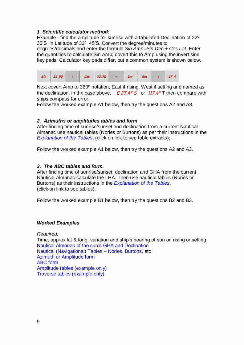
1. Scientific calculator method: Example - find the amplitude for sunrise with a tabulated Declination of 22º 30’S in Latitude of 33º 45’S. Convert the degree/minutes to degrees/decimals and enter the formula Sin Amp=Sin Dec ÷ Cos Lat. Enter
the quantities to calculate Sin Amp; covert this to Amp using the invert sine key pads. Calculator key pads differ, but a common system is shown below.
Next covert Amp to 360º notation, East if rising, West if setting and named as
the declination, in the case above, E 27.4º S or 117.4º T then compare with
ships compass for error. Follow the worked example A1 below, then try the questions A2 and A3.
2. Azimuths or amplitudes tables and form After finding time of sunrise/sunset and declination from a current Nautical Almanac use nautical tables (Nories or Burtons) as per their instructions in the Explanation of the Tables. (click on link to see table extracts):
Follow the worked example A1 below, then try the questions A2 and A3. 3. The ABC tables and form. After finding time of sunrise/sunset, declination and GHA from the current Nautical Almanac calculate the LHA. Then use nautical tables (Nories or Burtons) as their instructions in the Explanation of the Tables.
(click on link to see tables): Follow the worked example B1 below, then try the questions B2 and B3. Worked Examples Required:
Time, approx lat & long, variation and ship’s bearing of sun on rising or setting Nautical Almanac of the sun’s GHA and Declination Nautical (Navigational) Tables – Nories, Burtons, etc Azimuth or Amplitude form ABC form Amplitude tables (example only) Traverse tables (example only)
Sin 22.50 ÷ Cos 33.75 = Inv Sin = 27.4
10
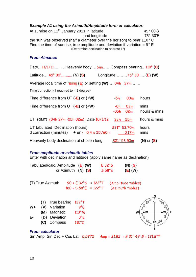
Example A1 using the Azimuth/Amplitude form or calculator:
At sunrise on 11th January 2011 in latitude 45° 00’S and longitude 75° 30’E the sun was observed (half a diameter over the horizon) to bear 110° C Find the time of sunrise, true amplitude and deviation if variation = 9° E
(Determine declination to nearest 1°)
From Almanac
Date…11/1/11.......…Heavenly body …Sun……Compass bearing…110° (C)
Latitude….45° 00’............ (N) (S) ....... Longitude………75° 30’..…(E) (W)
Average local time of rising (E) or setting (W)…..04h 27m …...
Time correction (if required to < 1 degree)
Time difference from UT (-E) or (+W) -5h 00m hours
Time difference from UT (-E) or (+W) -0h 02m mins
-05h 02m hours & mins
UT (GMT) (04h 27m -05h 02m) Date 10/1/12 23h 25m hours & mins
UT tabulated Declination (hours) S21° 53.70m hours
d correction (minutes) + or - 0.4 x 25’/60 = 0.17m mins
Heavenly body declination at chosen long. S21° 53.53m (N) or (S)
From amplitude or azimuth tables Enter with declination and latitude (apply same name as declination)
Tabulated/calc. Amplitude (E) (W) E 32°S (N) (S)
or Azimuth (N) (S) S 58°E (E) (W)
(T) True Azimuth 90 + E 32°S = 122°T (Amplitude tables)
180 - S 58°E = 122°T (Azimuth tables)
(T) True bearing 122°T
W+ (V) Variation 9°E
(M) Magnetic 113°M
E- (D) Deviation 3°E
(C) Compass 110°C
From calculator
Sin Amp=Sin Dec ÷ Cos Lat= 0.5272 Amp = 31.82 = E 31° 49’ S = 121.8°T
N
S
E W
AZI
AZI
AMP AMP
11
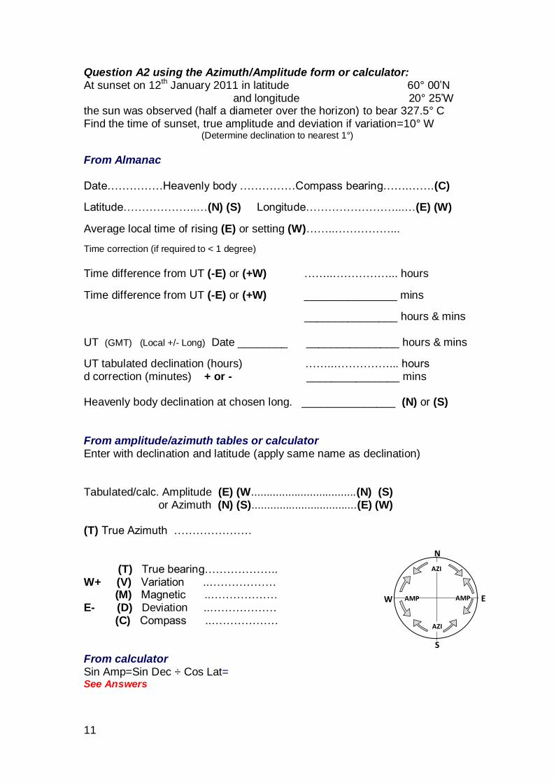
Question A2 using the Azimuth/Amplitude form or calculator: At sunset on 12th January 2011 in latitude 60° 00’N and longitude 20° 25’W the sun was observed (half a diameter over the horizon) to bear 327.5° C Find the time of sunset, true amplitude and deviation if variation=10° W
(Determine declination to nearest 1°)
From Almanac Date……………Heavenly body ……………Compass bearing…….…….(C)
Latitude………………..…(N) (S) Longitude……………………...…(E) (W)
Average local time of rising (E) or setting (W)……..……………...
Time correction (if required to < 1 degree)
Time difference from UT (-E) or (+W) ……..……………... hours
Time difference from UT (-E) or (+W) _______________ mins
_______________ hours & mins UT (GMT) (Local +/- Long) Date ________ _______________ hours & mins
UT tabulated declination (hours) ……..……………... hours d correction (minutes) + or - _______________ mins Heavenly body declination at chosen long. _______________ (N) or (S) From amplitude/azimuth tables or calculator Enter with declination and latitude (apply same name as declination) Tabulated/calc. Amplitude (E) (W..................................(N) (S) or Azimuth (N) (S)..................................(E) (W) (T) True Azimuth ………………… (T) True bearing……………….. W+ (V) Variation ..……………… (M) Magnetic ..……………… E- (D) Deviation ..……………… (C) Compass ..……………… From calculator Sin Amp=Sin Dec ÷ Cos Lat= See Answers
N
S
E W
AZI
AZI
AMP AMP

12
Question A3 using the Azimuth/Amplitude form or calculator: At sunrise on 16th November 2011 in latitude 35° 00’S and longitude 155° 30’E the sun was observed (half a diameter over the horizon) to bear 116° C Find the time of sunrise, true amplitude and deviation if variation = 10° E
(Determine declination to nearest 1°)
From Almanac Date……………Heavenly body ……………Compass bearing…….…….(C)
Latitude………………..…(N) (S) Longitude……………………...…(E) (W)
Average local time of rising (E) or setting (W)……..……………...
Time correction (if required to < 1 degree)
Time difference from UT (-E) or (+W) ……..……………... hours
Time difference from UT (-E) or (+W) _______________ mins
_______________ hours & mins UT (GMT) (Local +/- Long) Date ________ _______________ hours & mins
UT tabulated declination (hours) ……..……………... hours d correction (minutes) + or - _______________ mins Heavenly body declination at chosen long. _______________ (N) or (S) From amplitude/azimuth tables or calculator Enter with declination and latitude (apply same name as declination) Tabulated/calc. Amplitude (E) (W..................................(N) (S) or Azimuth (N) (S)..................................(E) (W) (T) True Azimuth ………………… (T) True bearing……………….. W+ (V) Variation ..……………… (M) Magnetic ..……………… E- (D) Deviation ..……………… (C) Compass ..……………… From calculator Sin Amp=Sin Dec ÷ Cos Lat= See Answers
N
S
E W
AZI
AZI
AMP AMP
13
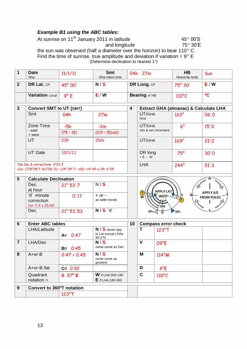
Example B1 using the ABC tables:
At sunrise on 11th January 2011 in latitude 45° 00’S and longitude 75° 30’E the sun was observed (half a diameter over the horizon) to bear 110° C Find the time of sunrise, true amplitude and deviation if variation = 9° E
(Determine declination to nearest 1°)
1 Date
Ship 11/1/11 Smt
Ship mean time 04h 27m HB
Heavenly body Sun
2 DR Lat. CP 45° 00’ N / S DR Long. CP 75° 30’ E / W
Variation Local 9° E E / W Bearing of HB
110°C ºC
3 Convert SMT to UT (GMT) 4 Extract GHA (almanac) & Calculate LHA
Smt 04h 27m UT/GHA hour
163° 06’.0
Zone Time - east + west
-5h -2m UT/GHA min & sec increment
6° 15’.0
(75 ÷ 15) (0.5 ÷ 15)x60
UT 23h 25m UT/GHA 169° 21’.0
UT Date 10/1/11 DR long + E - W
75° 30’.0
Tab Inc & corrections 6°21’.3
Calc. (178°05.7-163°06’.0) = (14° 59’.7 ÷ 60) =14’.99 x 25= 6°15’ LHA 244° 51’.3
5 Calculate Declination
Dec. at hour
21° 53’.7 N / S
‘d’ minute
correction Int. 0’.4 x 25/60
0’.17 + or – as table trends
Dec. 21° 53’.53 N / S ‘d’
6 Enter ABC tables 10 Compass error check
LHA/Latitude
A= 0.47
N / S name opp.
to Lat except LHAs 90-270
T 123°T
7 LHA/Dec
B= 0.45
N / S name same as Dec
V 09°E
8 A+or-B
0.47 + 0.45 N / S name same as greatest
M 114°M
A+or-B /lat C= 0.92 D 4°E
Quadrant notation =
S 57° E W if LHA 000-180
E if LHA 180-360 C 110°C
9 Convert to 360ºT notation
123°T
14
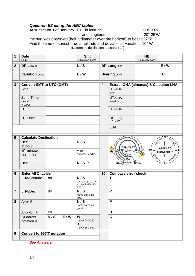
Question B2 using the ABC tables: At sunset on 12th January 2011 in latitude 60° 00’N and longitude 20° 25’W the sun was observed (half a diameter over the horizon) to bear 327.5° C Find the time of sunset, true amplitude and deviation if variation=10° W
(Determine declination to nearest 1°)
1 Date
Ship
Smt Ship mean time
HB Heavenly body
2 DR Lat. CP N / S DR Long. CP E / W
Variation Local E / W Bearing of HB
ºC
3 Convert SMT to UTC (GMT) 4 Extract GHA (almanac) & Calculate LHA
Smt UT/GHA hour
Zone Time - east + west
UT/GHA min & sec
UT UT/GHA
UT Date DR long + E - W
LHA
5 Calculate Declination
Dec. at hour
N / S
‘d’ minute correction
+ or – as table trends
Dec. N / S ‘d’
6 Enter ABC tables 10 Compass error check
LHA/Latitude A= N / S name opp. to Lat except LHAs 90-
270
T
7 LHA/Dec B= N / S name same as
Dec
V
8 A+or-B
N / S name same as
greatest
M
A+or-B /lat C= D
Quadrant notation =
N / S E / W W if LHA 000-180
E if LHA 180-360
C
9 Convert to 360ºT notation
See Answers
15
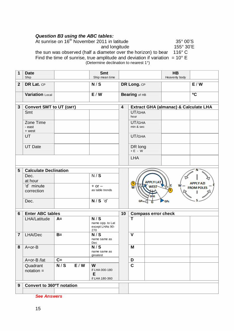
Question B3 using the ABC tables: At sunrise on 16
th November 2011 in latitude 35° 00’S
and longitude 155° 30’E the sun was observed (half a diameter over the horizon) to bear 116° C Find the time of sunrise, true amplitude and deviation if variation = 10° E
(Determine declination to nearest 1°)
1 Date
Ship
Smt Ship mean time
HB Heavenly body
2 DR Lat. CP N / S DR Long. CP E / W
Variation Local E / W Bearing of HB
ºC
3 Convert SMT to UT (GMT) 4 Extract GHA (almanac) & Calculate LHA
Smt UT/GHA hour
Zone Time - east + west
UT/GHA min & sec
UT UT/GHA
UT Date DR long + E - W
LHA
5 Calculate Declination
Dec. at hour
N / S
‘d’ minute correction
+ or – as table trends
Dec. N / S ‘d’
6 Enter ABC tables 10 Compass error check
LHA/Latitude A= N / S name opp. to Lat
except LHAs 90-270
T
7 LHA/Dec B= N / S name same as
Dec
V
8 A+or-B
N / S name same as
greatest
M
A+or-B /lat C= D
Quadrant notation =
N / S E / W W if LHA 000-180
E if LHA 180-360
C
9 Convert to 360ºT notation
See Answers
16
Position without a chart
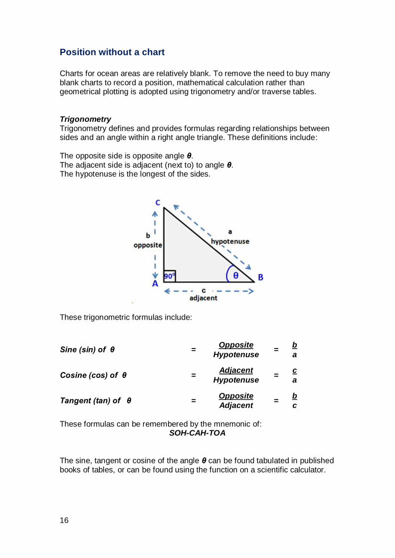
Charts for ocean areas are relatively blank. To remove the need to buy many blank charts to record a position, mathematical calculation rather than geometrical plotting is adopted using trigonometry and/or traverse tables. Trigonometry Trigonometry defines and provides formulas regarding relationships between sides and an angle within a right angle triangle. These definitions include: The opposite side is opposite angle θ. The adjacent side is adjacent (next to) to angle θ. The hypotenuse is the longest of the sides.
These trigonometric formulas include:
Sine (sin) of θ = Opposite
= b
Hypotenuse a
Cosine (cos) of θ = Adjacent
= c
Hypotenuse a
Tangent (tan) of θ = Opposite
= b
Adjacent c
These formulas can be remembered by the mnemonic of:
SOH-CAH-TOA The sine, tangent or cosine of the angle θ can be found tabulated in published books of tables, or can be found using the function on a scientific calculator.
17
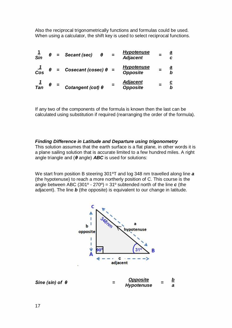
Also the reciprocal trigonometrically functions and formulas could be used. When using a calculator, the shift key is used to select reciprocal functions.
1 θ = Secant (sec) θ =
Hypotenuse =
a
Sin Adjacent c
1 θ = Cosecant (cosec) θ =
Hypotenuse =
a
Cos Opposite b
1 θ =
Cotangent (cot) θ =
Adjacent =
c
Tan Opposite b
If any two of the components of the formula is known then the last can be calculated using substitution if required (rearranging the order of the formula). Finding Difference in Latitude and Departure using trigonometry This solution assumes that the earth surface is a flat plane, in other words it is a plane sailing solution that is accurate limited to a few hundred miles. A right angle triangle and (θ angle) ABC is used for solutions: We start from position B steering 301ºT and log 348 nm travelled along line a (the hypotenuse) to reach a more northerly position of C. This course is the angle between ABC (301º - 270º) = 31º subtended north of the line c (the adjacent). The line b (the opposite) is equivalent to our change in latitude.
Sine (sin) of θ = Opposite
= b
Hypotenuse a
18
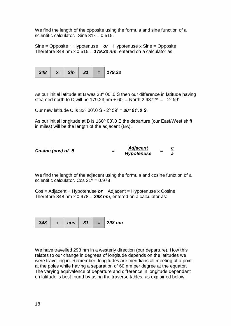
We find the length of the opposite using the formula and sine function of a scientific calculator. Sine 31º = 0.515. Sine = Opposite ÷ Hypotenuse or Hypotenuse x Sine = Opposite Therefore 348 nm x 0.515 = 179.23 nm, entered on a calculator as:
As our initial latitude at B was 33º 00’.0 S then our difference in latitude having steamed north to C will be 179.23 nm ÷ 60 = North 2.9872º = -2º 59’ Our new latitude C is 33º 00’.0 S - 2º 59’ = 30º 01’.0 S. As our initial longitude at B is 160º 00’.0 E the departure (our East/West shift in miles) will be the length of the adjacent (BA).
Cosine (cos) of θ = Adjacent
= c
Hypotenuse a
We find the length of the adjacent using the formula and cosine function of a scientific calculator. Cos 31º = 0.978 Cos = Adjacent ÷ Hypotenuse or Adjacent = Hypotenuse x Cosine Therefore 348 nm x 0.978 = 298 nm, entered on a calculator as:
We have travelled 298 nm in a westerly direction (our departure). How this relates to our change in degrees of longitude depends on the latitudes we were travelling in. Remember, longitudes are meridians all meeting at a point at the poles while having a separation of 60 nm per degree at the equator. The varying equivalence of departure and difference in longitude dependant on latitude is best found by using the traverse tables, as explained below.
348 x Sin 31 = 179.23
348 x cos 31 = 298 nm
19
Distance and courses using Traverse tables Trigonometric solutions are tabulated in the traverse tables using the definitions below: Rhumb line - A course line of constant true bearing. It crosses all meridians at the same angle and appears on a Mercator chart as a straight course line. It is adequate for short distances of less than a few hundred miles. Distance -A separation of between one point and another expressed in units
of length, for navigational purposes these being divisions of a nautical mile (equal to 1852 metres). Departure -The easting or westing of a vessel’s progress measured in nautical
miles. Note this is only equivalent to Difference Longitude on the equator. Difference in latitude -The angular distance from one parallel of latitude to
another, being approximately 60 nm per degree or 1 nm per minute. Difference in longitude - The angular distance from one meridian of longitude
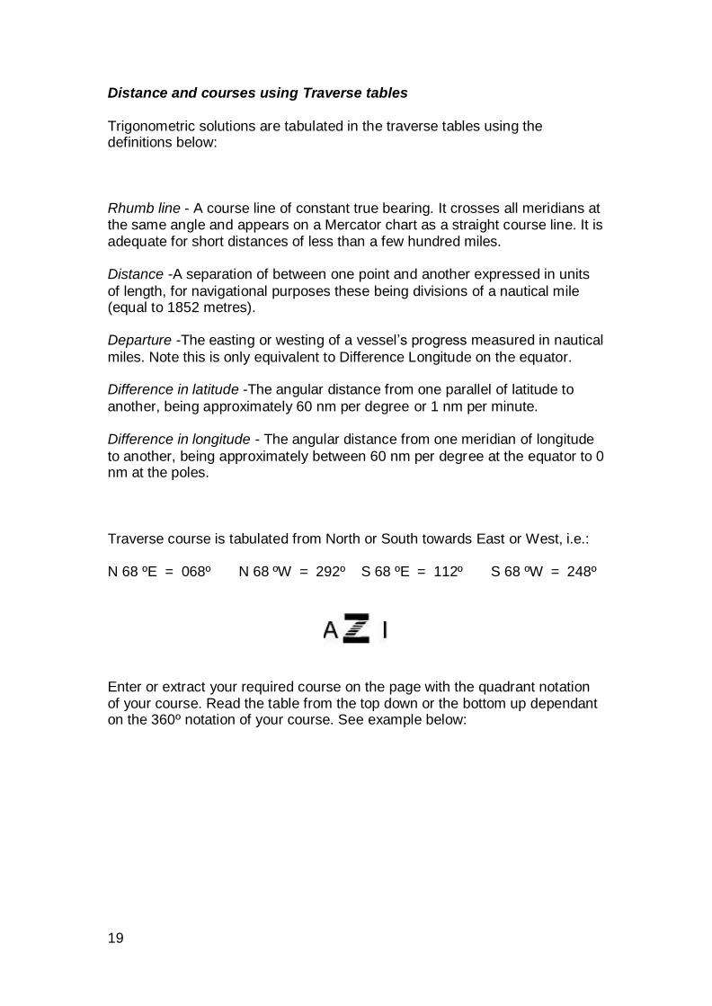
to another, being approximately between 60 nm per degree at the equator to 0 nm at the poles. Traverse course is tabulated from North or South towards East or West, i.e.: N 68 ºE = 068º N 68 ºW = 292º S 68 ºE = 112º S 68 ºW = 248º
Enter or extract your required course on the page with the quadrant notation of your course. Read the table from the top down or the bottom up dependant on the 360º notation of your course. See example below:

20
Example C1. At 09:00 in latitude 40° 00’S and longitude 150° 00’E a ship changes course to 112° T and steams at 8.4 knots until 19:00. Assuming no drift and steady course and speed, calculate the 19:00 position.
Finding Distance and Quadrant notation to enter tables.
19:00
-09:00
10 hours x 8.4 = Distance 84 nm steamed. Course 112° = S 68° E
Finding Difference in Latitude and Departure
From Page 68º reading from bottom up D. Lat = 31’.5 Dep = 77.9 miles
Old Latitude 40° 00’.0 S
Change in Latitude +31’.5 S
New Latitude 40° 31’.5 S
Finding Difference in Longitude at Mid Latitude
Mid Lat = (40° 31’.5 - 40° 00’.0) ÷ 2 + old lat = 40° 15’S
From Page top 40º use D’Long and Dep columns for nearest to Dep 77.9
Find D’Long 101’ Dep 77.4
D’Long 102’ Dep 78.1
Interpolate for D’Long correction for 77.9.
(D’Long increases 101’ to 102’ = 1’ between 77’.4 and 78’.1)
78’.1 77’.9
Interp = -77’.4 77’.4
0’.7 0’.5
0’.7 Dep increase is equivalent to 1’.0 D’Long increase.
0’.5 Dep increase is equivalent to 0’.5 ÷ 0’.7 = + 0’.71
D long 101’.0
Corr. + 0’.71
101’.71 ÷ 60 = 1° 41.71’E
Old Longitude 150° 00’.00E
Change in longitude +1° 41’.71E
New longitude 151° 41’.71E
21
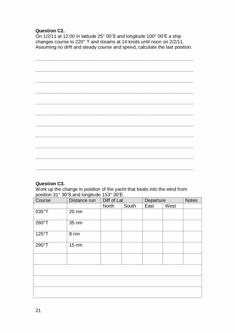
Question C2. On 1/2/11 at 12:00 in latitude 25° 00’S and longitude 100° 00’E a ship changes course to 220° T and steams at 14 knots until noon on 2/2/11. Assuming no drift and steady course and speed, calculate the last position. ____________________________________________________________ ____________________________________________________________ ____________________________________________________________ ____________________________________________________________ ____________________________________________________________ ____________________________________________________________ ____________________________________________________________ ____________________________________________________________ ____________________________________________________________ ____________________________________________________________ ____________________________________________________________ Question C3. Work up the change in position of the yacht that beats into the wind from position 31° 30’S and longitude 153° 30’E.
Course Distance run Diff of Lat Departure Notes
North South East West
035°T 20 nm
260°T 35 nm
125°T 8 nm
290°T 15 nm
22
Compass checks - Answers
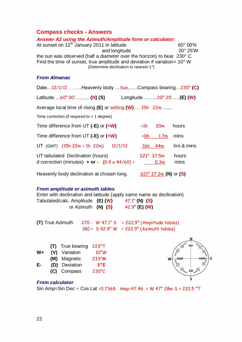
Answer A2 using the Azimuth/Amplitude form or calculator: At sunset on 12
th January 2011 in latitude 60° 00’N
and longitude 20° 25’W the sun was observed (half a diameter over the horizon) to bear 230° C Find the time of sunset, true amplitude and deviation if variation= 10° W
(Determine declination to nearest 1°)
From Almanac
Date…12/1/11.......…Heavenly body …Sun……Compass bearing…230° (C)
Latitude….60° 00’............ (N) (S) ....... Longitude………20° 25’..…(E) (W)
Average local time of rising (E) or setting (W)…..15h 22m …...
Time correction (if required to < 1 degree)
Time difference from UT (-E) or (+W) +1h 20m hours
Time difference from UT (-E) or (+W) +0h 1.7m mins
UT (GMT) (15h 22m + 1h 22m) 12/1/12 16h 44m hrs & mins
UT tabulated Declination (hours) S21° 37.5m hours
d correction (minutes) + or - (0.4 x 44/60) = 0.3m mins
Heavenly body declination at chosen long. S21° 37.2m (N) or (S)
From amplitude or azimuth tables Enter with declination and latitude (apply same name as declination)
Tabulated/calc. Amplitude (E) (W) 47.1° (N) (S)
or Azimuth (N) (S) 42.9° (E) (W)
(T) True Azimuth 270 - W 47.1° S = 222.9° (Amplitude tables)
180 + S 42.9° W = 222.9° (Azimuth tables)
(T) True bearing 223°T
W+ (V) Variation 10°W
(M) Magnetic 233°M
E- (D) Deviation 3°E
(C) Compass 230°C
From calculator
Sin Amp=Sin Dec ÷ Cos Lat =0.7368 Amp=47.46 = W 47° 28m S = 222.5 °T
N
S
E W
AZI
AZI
AMP AMP
23
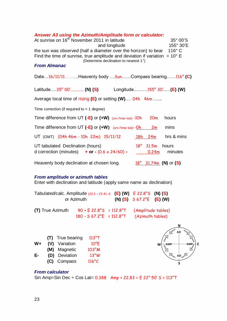
Answer A3 using the Azimuth/Amplitude form or calculator: At sunrise on 16
th November 2011 in latitude 35° 00’S
and longitude 155° 30’E the sun was observed (half a diameter over the horizon) to bear 116° C Find the time of sunrise, true amplitude and deviation if variation = 10° E
(Determine declination to nearest 1°)
From Almanac
Date…16/11/11.......…Heavenly body …Sun……Compass bearing……116° (C)
Latitude….35° 00’............ (N) (S) ....... Longitude………155° 30’..…(E) (W)
Average local time of rising (E) or setting (W)…..04h 46m …...
Time correction (if required to < 1 degree)
Time difference from UT (-E) or (+W) (arc/time tab) -10h 20m hours
Time difference from UT (-E) or (+W) (arc/time tab) -0h 2m mins
UT (GMT) (04h 46m - 10h 22m) 15/11/12 18h 24m hrs & mins
UT tabulated Declination (hours) 18° 31.5m hours
d correction (minutes) + or - (0.6 x 24/60) = 0.24m minutes
Heavenly body declination at chosen long. 18° 31.74m (N) or (S)
From amplitude or azimuth tables Enter with declination and latitude (apply same name as declination)
Tabulated/calc. Amplitude (22.2 + 23.4) ÷2 (E) (W) E 22.8°S (N) (S)
or Azimuth (N) (S) S 67.2°E (E) (W)
(T) True Azimuth 90 + E 22.8°S = 112.8°T (Amplitude tables)
180 - S 67.2°E = 112.8°T (Azimuth tables)
(T) True bearing 113°T
W+ (V) Variation 10°E
(M) Magnetic 103°M
E- (D) Deviation 13°W
(C) Compass 116°C
From calculator
Sin Amp=Sin Dec ÷ Cos Lat= 0.388 Amp = 22.83 = E 22° 50’ S = 113°T
N
S
E W
AZI
AZI
AMP AMP
24
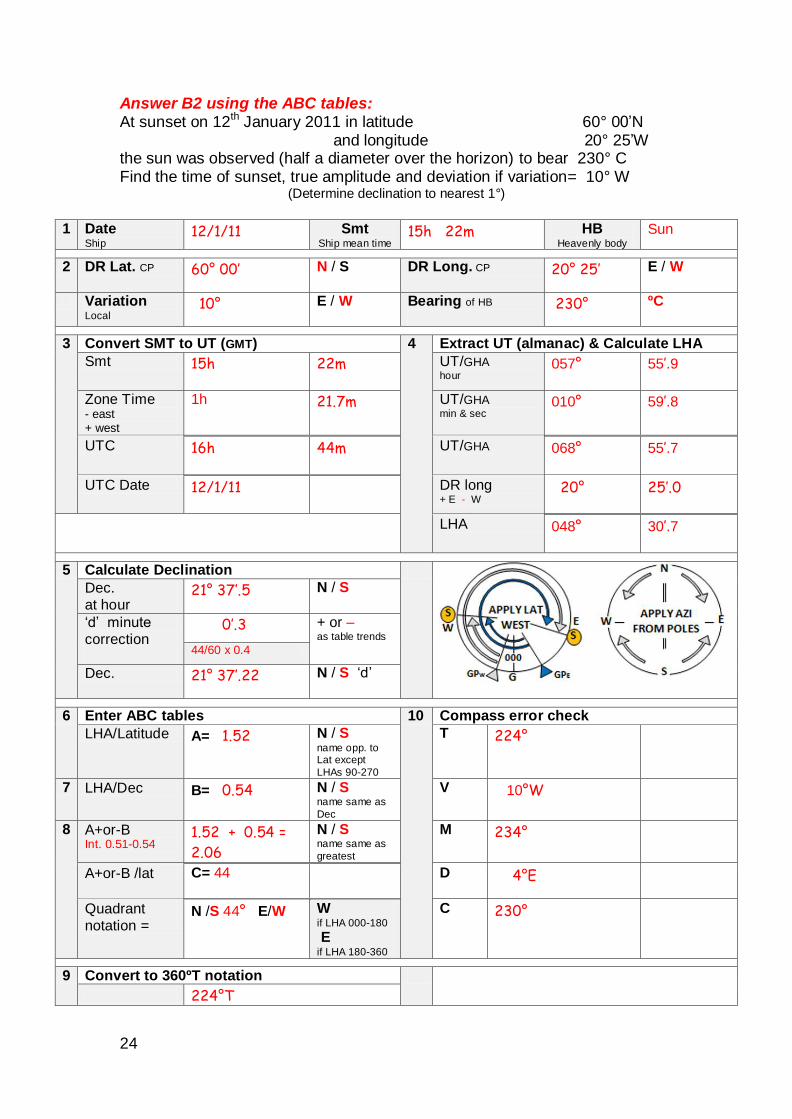
Answer B2 using the ABC tables: At sunset on 12th January 2011 in latitude 60° 00’N and longitude 20° 25’W the sun was observed (half a diameter over the horizon) to bear 230° C Find the time of sunset, true amplitude and deviation if variation= 10° W
(Determine declination to nearest 1°)
1 Date
Ship 12/1/11 Smt
Ship mean time 15h 22m HB
Heavenly body Sun
2 DR Lat. CP 60° 00’ N / S DR Long. CP 20° 25’ E / W
Variation Local
10° E / W Bearing of HB
230° ºC
3 Convert SMT to UT (GMT) 4 Extract UT (almanac) & Calculate LHA
Smt 15h 22m UT/GHA hour
057° 55’.9
Zone Time - east + west
1h 21.7m UT/GHA min & sec
010° 59’.8
UTC 16h 44m UT/GHA 068° 55’.7
UTC Date 12/1/11 DR long + E - W
20° 25’.0
LHA 048° 30’.7
5 Calculate Declination
Dec. at hour
21° 37’.5 N / S
‘d’ minute
correction
0’.3 + or – as table trends
44/60 x 0.4
Dec. 21° 37’.22 N / S ‘d’
6 Enter ABC tables 10 Compass error check
LHA/Latitude A= 1.52 N / S name opp. to Lat except
LHAs 90-270
T 224°
7 LHA/Dec B= 0.54 N / S name same as
Dec
V 10°W
8 A+or-B Int. 0.51-0.54
1.52 + 0.54 =
2.06
N / S name same as
greatest
M 234°
A+or-B /lat C= 44 D 4°E
Quadrant notation =
N /S 44° E/W W if LHA 000-180
E if LHA 180-360
C 230°
9 Convert to 360ºT notation
224°T
25
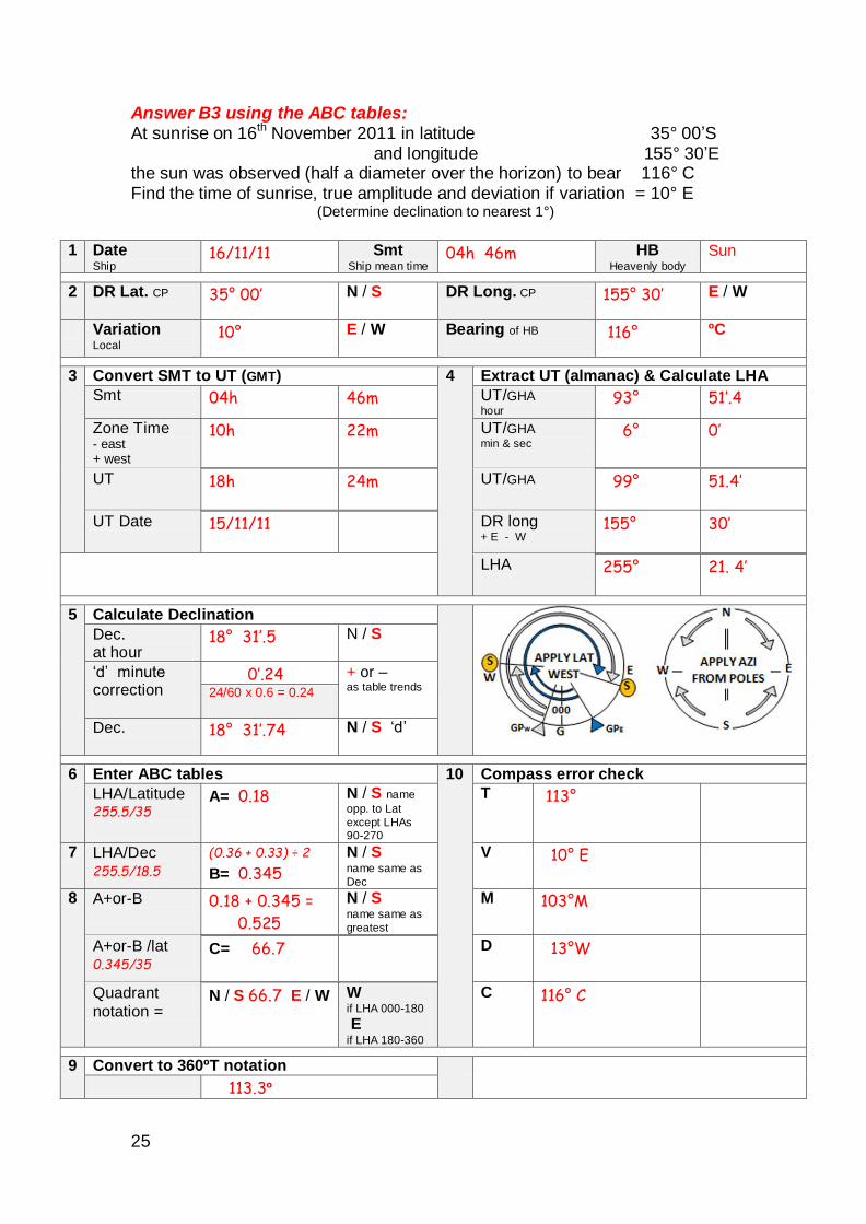
Answer B3 using the ABC tables: At sunrise on 16th November 2011 in latitude 35° 00’S and longitude 155° 30’E the sun was observed (half a diameter over the horizon) to bear 116° C Find the time of sunrise, true amplitude and deviation if variation = 10° E
(Determine declination to nearest 1°)
1 Date
Ship 16/11/11 Smt
Ship mean time 04h 46m HB
Heavenly body Sun
2 DR Lat. CP 35° 00’ N / S DR Long. CP 155° 30’ E / W
Variation Local
10° E / W Bearing of HB
116° ºC
3 Convert SMT to UT (GMT) 4 Extract UT (almanac) & Calculate LHA
Smt 04h 46m UT/GHA hour
93° 51’.4
Zone Time - east + west
10h 22m UT/GHA min & sec
6° 0’
UT 18h 24m UT/GHA 99° 51.4’
UT Date 15/11/11 DR long + E - W
155° 30’
LHA 255° 21. 4’
5 Calculate Declination
Dec. at hour
18° 31’.5 N / S
‘d’ minute correction
0’.24 + or – as table trends
24/60 x 0.6 = 0.24
Dec. 18° 31’.74 N / S ‘d’
6 Enter ABC tables 10 Compass error check
LHA/Latitude 255.5/35
A= 0.18 N / S name
opp. to Lat
except LHAs 90-270
T 113°
7 LHA/Dec 255.5/18.5
(0.36 + 0.33) ÷ 2
B= 0.345
N / S name same as
Dec
V 10° E
8 A+or-B
0.18 + 0.345 =
0.525
N / S name same as
greatest
M 103°M
A+or-B /lat 0.345/35
C= 66.7 D 13°W
Quadrant notation =
N / S 66.7 E / W W if LHA 000-180
E if LHA 180-360
C 116° C
9 Convert to 360ºT notation
113.3º
26
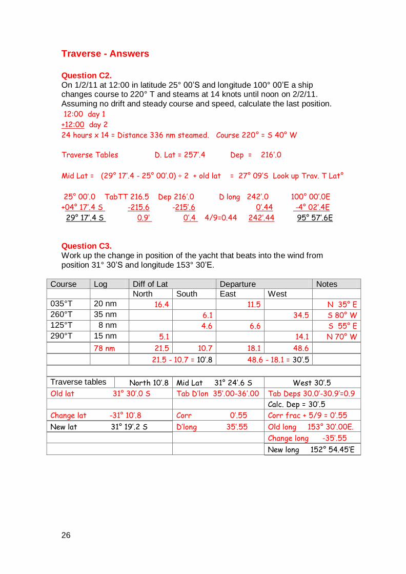
Traverse - Answers
Question C2. On 1/2/11 at 12:00 in latitude 25° 00’S and longitude 100° 00’E a ship changes course to 220° T and steams at 14 knots until noon on 2/2/11. Assuming no drift and steady course and speed, calculate the last position.
12:00 day 1
+12:00 day 2
24 hours x 14 = Distance 336 nm steamed. Course 220° = S 40° W
Traverse Tables D. Lat = 257’.4 Dep = 216’.0
Mid Lat = (29° 17’.4 - 25° 00’.0) ÷ 2 + old lat = 27° 09’S Look up Trav. T Lat°
25° 00’.0 TabTT 216.5 Dep 216’.0 D long 242’.0 100° 00’.0E
+04° 17’.4 S -215.6 -215’.6 0’.44 -4° 02’.4E
29° 17’.4 S 0.9’ 0’.4 4/9=0.44 242’.44 95° 57’.6E Question C3. Work up the change in position of the yacht that beats into the wind from position 31° 30’S and longitude 153° 30’E.
Course Log Diff of Lat Departure Notes
North South East West
035°T 20 nm 16.4 11.5 N 35° E
260°T 35 nm 6.1 34.5 S 80° W
125°T 8 nm 4.6 6.6 S 55° E
290°T 15 nm 5.1 14.1 N 70° W
78 nm 21.5 10.7 18.1 48.6
21.5 - 10.7 = 10’.8 48.6 - 18.1 = 30’.5
Traverse tables North 10’.8 Mid Lat 31° 24’.6 S West 30’.5
Old lat 31° 30’.0 S Tab D’lon 35’.00-36’.00 Tab Deps 30.0’-30.9’=0.9
Calc. Dep = 30’.5
Change lat -31° 10’.8 Corr 0’.55 Corr frac + 5/9 = 0’.55
New lat 31° 19’.2 S D’long 35’.55 Old long 153° 30’.00E.
Change long -35’.55
New long 152° 54.45’E