Natural Disasters in Tasmania Publications/disaster_resilience... · Natural Disasters in Tasmania...
24
Natural Disasters in Tasmania 2012 State Risk Assessment Report Summary
Transcript of Natural Disasters in Tasmania Publications/disaster_resilience... · Natural Disasters in Tasmania...
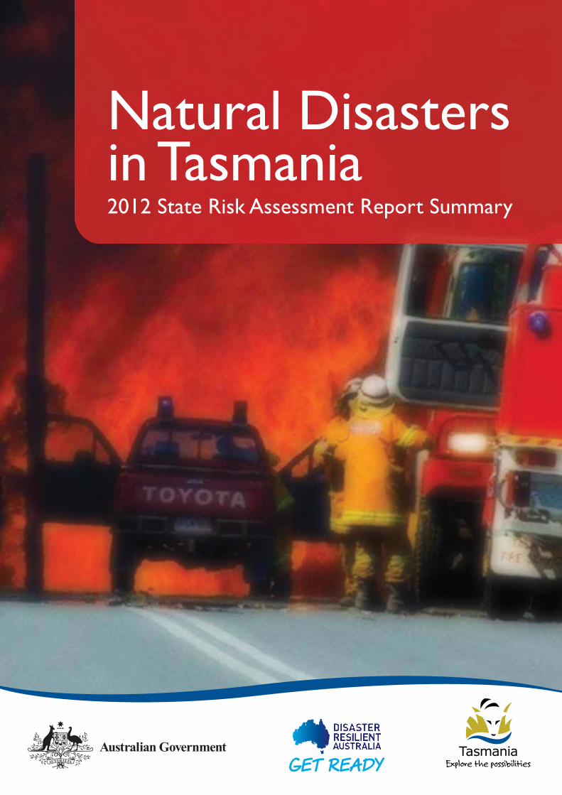
Natural Disastersin Tasmania2012 State Risk Assessment Report Summary
DisclaimerThis document is a condensed summary of the results of the2012 Tasmanian Natural Disaster Risk Assessment Report.
The assessment was based on data available at the time,validated by emergency management representatives and theopinion of hazard experts. As a consequence there areinherent uncertainties in the assessment. Whilst every efforthas been made to ensure the material in this report isaccurate, the State Emergency Service provides no warranty,guarantee or representation that material is accurate,complete, up to date, non-infringing or fit for any particularpurpose. The use of the material is entirely at the risk of theuser. The user must independently verify the suitability of thematerial for its intended use.
CopyrightCopyright of this document is vested in the Tasmanian StateEmergency Service © 2012. Inquiries related to copyrightshould be addressed to:
State Emergency ServicePO Box 1290HOBART TAS 700103 6230 2700
Certain text and diagrams in this document are drawn from the National Emergency Risk Assessment Guidelines.That work is copyright to the Commonwealth of Australiaand each of its states and territories 2011.

Natural Disasters in Tasmania - 2012 State Risk Assessment Report Summary 3
1 INTRODUCTION 4
1.1 Overview 41.2 What is a natural disaster? 41.3 What are Tasmania’s natural hazards? 41.4 Other hazards 4
2 THE RISK ASSESSMENT PROCESS 5
2.1 What is the difference between hazard and risk? 52.2 How are Tasmania’s natural disaster risks assessed? 52.3 How are the impacts of a disaster assessed? 52.4 How is the likelihood of a disaster determined? 7
3 WHAT ARE TASMANIA’S MOST SIGNIFICANTNATURAL DISASTER RISKS? 8
4 HOW ARE RISKS TREATED? 10
5 HAZARD SUMMARIES 11
5.1 Bushfire 115.2 Flooding 125.3 Storms 145.4 Earthquake 155.5 Landslide 175.6 Tsunami 19
6 OTHER HAZARDS 21
7 CONCLUSION 22
Table of Contents
1.1 Overview
This document has been developed to help the Tasmaniancommunity better understand how emergency managementdecisions are informed in cases of natural disaster.
It is a broad overview of the 2012 Tasmanian State NaturalDisaster Risk Assessment.
The main aim of the risk assessment is to help theTasmanian community to be better prepared for disaster. Itdoes this through an increased understanding andawareness of the natural disasters that have the mostpotential to impact the State.
1.2 What is a natural disaster?
In a nationally agreed definition a natural disaster is defined as:
“A serious disruption to a community or region caused by theimpact of a naturally occurring rapid onset event that alsothreatens or causes death, injury or damage to property or theenvironment; and requires a significant and coordinated multi-agency and community response”.
Based on this definition, a natural disaster is an event causedby any one, or a combination, of the following natural hazards:
• bushfire;
• earthquake;
• flood;
• storm;
• cyclone;
• storm surge;
• landslide;
• tsunami;
• meteorite strike; or
• tornado.
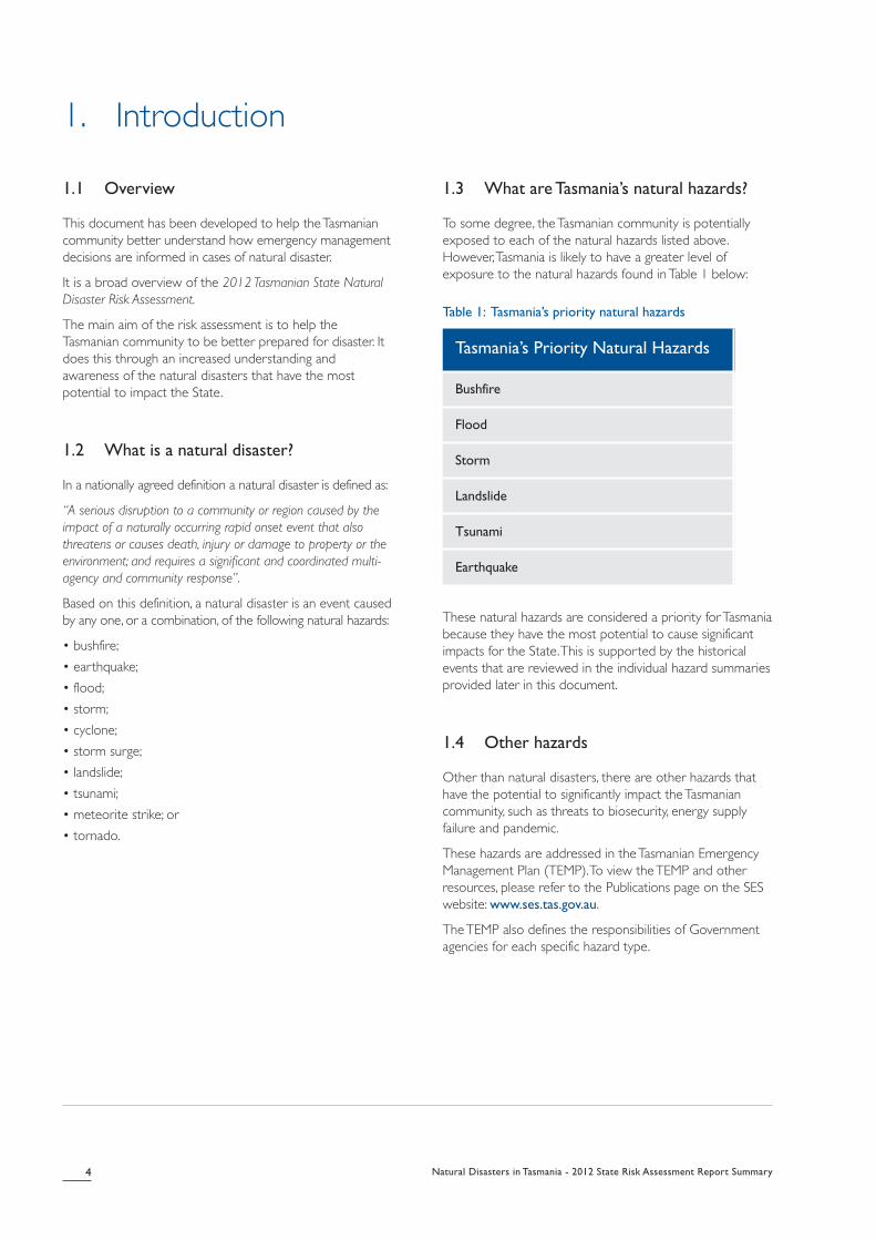
1.3 What are Tasmania’s natural hazards?
To some degree, the Tasmanian community is potentiallyexposed to each of the natural hazards listed above.However, Tasmania is likely to have a greater level ofexposure to the natural hazards found in Table 1 below:
Table 1: Tasmania’s priority natural hazards
These natural hazards are considered a priority for Tasmaniabecause they have the most potential to cause significantimpacts for the State. This is supported by the historicalevents that are reviewed in the individual hazard summariesprovided later in this document.
1.4 Other hazards
Other than natural disasters, there are other hazards thathave the potential to significantly impact the Tasmaniancommunity, such as threats to biosecurity, energy supplyfailure and pandemic.
These hazards are addressed in the Tasmanian EmergencyManagement Plan (TEMP). To view the TEMP and otherresources, please refer to the Publications page on the SESwebsite: www.ses.tas.gov.au.
The TEMP also defines the responsibilities of Governmentagencies for each specific hazard type.
4 Natural Disasters in Tasmania - 2012 State Risk Assessment Report Summary
1. Introduction
Tasmania’s Priority Natural Hazards
Bushfire
Flood
Storm
Landslide
Tsunami
Earthquake

Natural Disasters in Tasmania - 2012 State Risk Assessment Report Summary 5
2.1 What is the difference betweenhazard and risk?
There is an important distinction between hazard and risk.For a hazard to warrant an emergency managementresponse, it must present a risk to something important,such as life or property.
2.2 How are Tasmania’s natural disaster risks assessed?
Tasmania uses a nationally agreed methodology for the riskmanagement process, which is shown below:
Fig. 1: Risk management process (from NationalEmergency Risk Assessment Guidelines( NERAG), p.9)
A panel of hazard experts and emergency managementrepresentatives from across government identifies priorityhazard risks.
The assessment utilises a worst case scenario for eachhazard type. The worst case is determined from an analysisof Tasmania’s historical experience with natural hazarddisasters, current research in relation to Tasmania’s changingclimate and emerging threats.
2.3 How are the impacts of a disasterassessed?
Once potential worst-case scenarios have beendetermined, the existing emergency management capabilityfor each priority hazard is assessed. This ensures that theassessment takes into account existing measures that mightreduce or mitigate the impact of a natural disaster event. Italso allows any current gaps or deficiencies to be identifiedwhich helps prioritise areas for research and futuremitigation.
The consequences of a natural disaster event are thendetermined according to its impact across six categories:
People: Considers the number of expected fatalities orinjuries. This also includes consideration of the impact onthe state’s health system to cope.
Environment: Considers the extent of any loss orimpairment of ecosystems, flora and fauna.
Economy: Considers the economic impact, in particular thevalue of assets destroyed or damaged as a result of thedisaster event.
Public Administration: Considers the ability of governmentand authorities to manage the event and maintain publicorder.
Social Setting: Considers the effect of the event onculturally significant assets, the impact on quality of life andother emotional and psychological impacts.
Infrastructure: Considers the severity of damage or loss ofcritical infrastructure including roads, utilities and otherlifelines.
2. The risk assessment process
Com
municate and consult
Establish the context
Identify risks
Analyse risks
Evaulate risks
Risk assesment
Monitor and review
Treat risks

The table below shows the way these impact categories are assessed relative to a potential worst-case natural disaster event in Tasmania:
Table 2: Consequence assessment criteria (adapted from NERAG)
6 Natural Disasters in Tasmania - 2012 State Risk Assessment Report Summary
LevelPeopleFatalities per headof population
EnvironmentEconomy% of Tasmanianannual GDP
Public Admin.Capacity ofgovernment
Social Setting Infrastructure
1:10,000 Loss of eco-systems
>3% Unable tomanage
All deeplyaffected
Long-termfailure
1:100,000 Severeimpairment
1-3% Struggle to cope Most deeplyaffected
Mid to long-term failure
1:1M Significantimpairment
0.3-1% Diversion frompolicy
Some deeplyaffected
Mid-term failure
Serious Injuries Isolated damage 0.1-0.3% Somedisturbance
Reducedservices
Short to mid-term failure
Minor Injuries Little damage <0.1% Copes fine Little to noimpacts
Short termfailure
Cat
astr
ophi
cM
ajor
Mod
erat
eM
inor
Insi
gnifi
cant
Natural Disasters in Tasmania - 2012 State Risk Assessment Report Summary 7
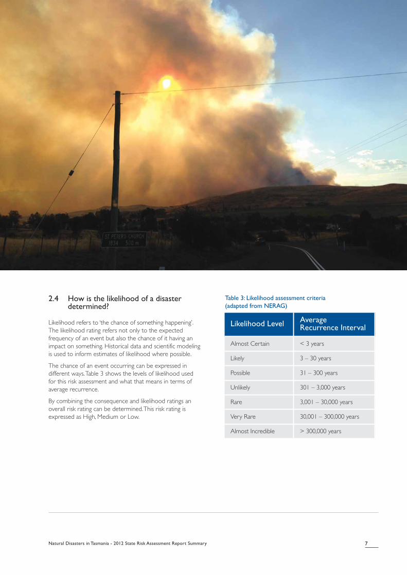
2.4 How is the likelihood of a disasterdetermined?
Likelihood refers to ‘the chance of something happening’.The likelihood rating refers not only to the expectedfrequency of an event but also the chance of it having animpact on something. Historical data and scientific modelingis used to inform estimates of likelihood where possible.
The chance of an event occurring can be expressed indifferent ways. Table 3 shows the levels of likelihood usedfor this risk assessment and what that means in terms ofaverage recurrence.
By combining the consequence and likelihood ratings anoverall risk rating can be determined. This risk rating isexpressed as High, Medium or Low.
Table 3: Likelihood assessment criteria(adapted from NERAG)
Likelihood Level Average Recurrence Interval
Almost Certain < 3 years
Likely 3 – 30 years
Possible 31 – 300 years
Unlikely 301 – 3,000 years
Rare 3,001 – 30,000 years
Very Rare 30,001 – 300,000 years
Almost Incredible > 300,000 years

Table 4 below summarises the results of the 2012 Tasmanian State Natural Disaster Risk Assessment.
Table 4: Tasmania’s Natural Disaster Risk Register 2012 (summarised and condensed)
Bushfire and Flooding are identified as Tasmania’s mostsignificant natural hazard risk types. Bushfires generally havegreater consequences in the southeast of the State,whereas flooding is generally more frequent with greaterconsequences in the northeast and northwest.
Severe Storms were also found to pose potential risks inTasmania. While the island is not exposed to cyclonicwinds, it has experienced destructive localised tornadoes inthe past. Tasmania is exposed to frequent storm and severewind events, which generally have minor localised impacts.
Low to medium risks were identified when assessing worst-case scenarios for earthquake, tsunami and fast movinglandslide events.
Earthquakes are rare to unlikely but have catastrophicpotential. Tsunamis are also rare but a worst-case eventwould have major impacts. Landslides are frequent and havecaused a significant amount of property damage in Tasmania
over many years, but the majority of those landslide eventsdo not pose a threat to life nor require an emergencyresponse. However, some types of fast moving landslideevents do also occur in Tasmania and potentially pose athreat to life.
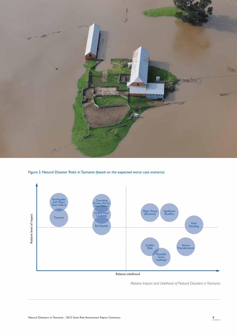
Figure 2 (see over page) depicts each of the identified risksaccording to their relative likelihood and impact. Furtherdetail in respect to each priority hazard is provided in thenext section of this report.
Looking at this diagram, the risks that reside in the upperright quadrant warrant greater attention as they representhigh impact risks that also have a high likelihood ofoccurrence, relative to the other disaster risks.
8 Natural Disasters in Tasmania - 2012 State Risk Assessment Report Summary
3. What are Tasmania’s most significant naturaldisaster risks?
Natural DisasterRisk Scenario
OverallConsequence
OverallLikelihood
OverallRisk Rating
Bushfire CATASTROPHIC POSSIBLE-LIKELY HIGH
Flooding CATASTROPHIC POSSIBLE HIGH
Flash Flooding MODERATE LIKELY HIGH
Private Dam Failure (Cascading) MAJOR UNLIKELY MEDIUM
Severe Storm MODERATE LIKELY MEDIUM
Earthquake with major dam failure CATASTROPHIC/MAJOR RARE MEDIUM
Debris Flow Landslide CATASTROPHIC/MAJOR UNLIKELY MEDIUM
Earthquake near major city
eg Hobart, Launceston
MAJOR/MODERATE UNLIKELY MEDIUM-LOW
Tsunami MAJOR RARE MEDIUM-LOW
Sudden Landslide MODERATE POSSIBLE LOW
Natural Disasters in Tasmania - 2012 State Risk Assessment Report Summary 9
Figure 2. Natural Disaster Risks in Tasmania (based on the expected worst case scenario)
Relative Impact and Likelihood of Natural Disasters in Tasmania
Rel
ativ
e le
vel of im
pac
t
Relative Likelihood
Earthquake
Debris FlowLandslide
Major Flood(Riverine)
SuddenSlide
SevereThunderstorm
Rockfall(onto
roadway)
SignificantBushfire
FlashFlooding
Tsunami
Earthquakewith MajorDam Failure
CascadingPrivate (Farm)Dam Failure
Risk treatment is where strategies are developed in order to:
• Avoid, share or retain the risk (eg: insurance, recoveryassistance)
• Remove the hazard (source of risk)
• Reduce the likelihood of the event occurring
• Reduce the consequences if the event occurs.
Under Tasmania’s emergency management framework,specific risk management responsibilities are outlined atthree levels - municipal, regional and state.
Most risks associated with natural hazards are managed atthe Local Government level, with emergency managementcommittees responsible for identifying, assessing, treatingand managing risks. These committees maintain risk registersand emergency management plans that are required to bereviewed every two years.
At the regional level, the Regional Emergency ManagementCommittee (REMC) has responsibility for research, riskassessment and risk reduction in partnership with StateGovernment and relevant local authorities.
At the State Government level, the State EmergencyManagement Committee (SEMC) has responsibility foremergency management arrangements and strategies. The2012 Tasmanian State Natural Disaster Risk Assessment andits findings are therefore the responsibility of thisCommittee.
As a product of the 2012 Tasmanian State Natural DisasterRisk Assessment, risk treatment strategies have been
identified for each of the priority hazards, which ifimplemented, aim to reduce the level of overall risk. Aspart of its responsibilities, the SEMC monitors and reviewsthe implementation of the risk treatment strategies byrelevant agencies and authorities.
Tasmania’s emergency risk management framework ensuresthat all efforts are made to keep natural disaster risks inTasmania at a level that is as low as reasonably practicable.A second edition of the state risk assessment will also beundertaken. This is scheduled to occur between 2013 and2017.
A major project is presently underway within Tasmaniawhich is reviewing and consolidating land use planningschemes to improve consistency in the way hazards,including natural hazards, are mitigated throughdevelopment and use of land.
In addition to the responsibilities of the State and LocalGovernments, it is important to consider that communitieshave a role to play in mitigating risks.
This includes individuals taking steps to understand the risksthat may affect them and ensuring that they take action toprotect themselves, their assets and their livelihoods.
Risk management strategies include the need to empowerindividuals and communities to exercise choice and takeresponsibility and therefore become more resilient.
10 Natural Disasters in Tasmania - 2012 State Risk Assessment Report Summary
4. How are risks treated?

Natural Disasters in Tasmania - 2012 State Risk Assessment Report Summary 11
Summaries of each of the identified priority natural hazardtypes are provided in this section. Each section includes adescription of the hazard, previous significant events, currentmanagement arrangements and information on where toget further information.
5.1 Bushfire
In human and economic terms bushfire has been the mostcostly natural disaster hazard in Tasmania’s history. Bushfireshave claimed more lives than any other natural hazard, andcarry an average annual cost of $11.2M.
The bushfires that swept through Hobart and surroundingareas on Tuesday 7 February 1967 resulted in the deaths of62 people. Until the Black Saturday bushfires in Victoria in2009, this was the highest number of fatalities from bushfirein a single day experienced in Australia.
Bushfires in Tasmania are most commonly associated withdry conditions during summer and autumn. Peak bushfiredanger periods vary according to the rainfall distributionover spring to autumn. Large differences in rainfalldistribution across the State affect when and where
bushfires occur. Tasmania is considered periodicallyvulnerable to bushfire due to the level of vegetation coveracross the State, the unique population spread and therelationship between high rainfall/low evaporation on fuelloads.
Whilst bushfires can, and do impact all over the state, thesouth east of the state remains at most risk of acatastrophic bushfire. Emergency management capabilitiesand arrangements have improved significantly since 1967,however Tasmania continues to experience similar weatherconditions as were experienced at that time. Increases inpopulation, particularly in rural areas and the ‘urban fringe’have led to an increased level of exposure to bushfirehazard.
Many recent fire events were identified that had thepotential to cause significant impact on the Tasmaniancommunity. These fires may have been more damagingwere it not for favourable weather changes and/or theeffectiveness of our response to the event.
5.1.1 Previous significant bushfires
The most significant bushfire events experienced inTasmania in recent history are listed in the table below:
5. Hazard summaries
Table 5: Significant Fire Events in Tasmania's History
Event Date AreaBurnt(ha)
Mortality Rate PeopleInjured
Estimated Cost NERAG Risk Rating
Black Tuesday, Hobart& Surrounding AreaFires
Feb1967
264270 1.7 deaths per
10,000 people
62 dead
(Pop: 375,397)
900 $45M (1967)$485M (2010with inflation)
CATASTROPHIC/
POSSIBLE
Mt Wellington &Hobart Region Fires
Dec
1897
N/K 0.4 deaths per
10,000 people
6 dead
(Pop: 161,629)
N/K Likely to havebeen $47.3M-$141.9M in todaysterms
CATASTROPHIC25/
POSSIBLE
Huon - Port CygnetFires
Jan
1854
N/K 1.6 deaths per
10,000 people
14 dead
(Pop: 88,752)
10 Likely to havebeen $14.2-$47.3M in todaysterms
CATASTROPHIC/
POSSIBLE
5.1.2 How are bushfire risks managed?
In Tasmania, three major agencies provide fire services. Theyare the Tasmania Fire Service (TFS), Parks and WildlifeService (PWS) and Forestry Tasmania (FT). These agencieshave cooperative arrangements in place for multi-agencyresponse.
Mitigation activities may include:
• Fuel reduction activities;
• Fire education programs;
• Protection of vulnerable critical infrastructure such aspower supply, water supply and sewerage treatmentplants;
• Well-developed processes and resources for managingsignificant bushfires;
• Emergency response capability maintained.
5.1.3 Where do I go for further information on bushfire
risk mitigation?
For information on how to reduce bushfire risk, the TFS hasseveral informative bushfire safety publications. To viewthese, please refer to the Publications page on the TFSwebsite: www.fire.tas.gov.au.
The TFS bushfire safety program ‘Prepare-Act-Survive’ canalso be found on the TFS website.
5.2 Flooding
Tasmania supports 12% of Australia’s freshwater resourcesin an area of less than 1% of the total Australian land area.The state has extensive river and stream systems withapproximately 150,000 kilometres of waterways. The twomajor river systems in Tasmania are the Derwent and theSouth Esk. There are many smaller systems, especially in thewestern region, which flow to the west coast.
Tasmanian rivers and catchments are subject to floodingfollowing heavy rainfall events, or after a period of morethan a few days heavy rain in one area. Catchmentbehaviours are sometimes difficult to predict, with someriver systems able to cope with heavy rainfall eventsdepending on precisely where the rain falls. Communitiesdownstream of large catchments are exposed to floodingfrom time to time, particularly those situated in floodplains.
Tasmania is exposed to major consequence flooding,particularly in the north east of the state. There has been anoticeable increase in the frequency of short duration, butintense rainfall events in recent years. This is supported byclimate change observations and predicted future models.
There are now more effective emergency managementarrangements and levee systems in the north of the statethat lessen the impact from major flooding, but if the eventwas significant enough it would test those mitigation andresponse arrangements.
There is also the potential for damage to property and lossof life arising from a cascading dam failure upstream ofcommunities. Further analysis of this risk is beingundertaken in order to increase awareness and informpeople who may be at risk.
Flash flooding is also associated with heavy rainfall andpresents its own unique risks. Flash flooding is difficult topredict and often arrives without warning. It is exacerbatedby blocked drainage systems and so can be more serious inbuilt-up urban areas. Further analysis of this risk is alsobeing undertaken and Tasmania SES is presently developingawareness programs.
5.2.1 Previous significant floods
The most significant flooding event in Tasmania was thewidespread flooding that affected the northeast and partsof the northwest in April 1929 and resulted in 22 deaths.More than 500mm of rain fell over 3 days, resulting inflooding to most rivers. Launceston was flooded andapproximately 4500 people were temporarily displaced.While many parts of the north were flooded, the mostsignificant impacts occurred in Derby, where the failure ofthe Briseis Dam resulted in 14 people being killed, and inGawler, 8 people died when a truck crossing a floodedbridge was swept away.
In 2011 there was a series of floods that impacted mostly inthe north east of Tasmania during the months of January,March and August. In isolation, each of these floods hadonly relatively minor impacts, however the cumulative effectof these floods increased the overall impact on localcommunities. The resulting damage to local infrastructureand property from the 2011 floods resulted in assistancefrom the Commonwealth, highlighting the state levelsignificance of these events.
12 Natural Disasters in Tasmania - 2012 State Risk Assessment Report Summary
Natural Disasters in Tasmania - 2012 State Risk Assessment Report Summary 13
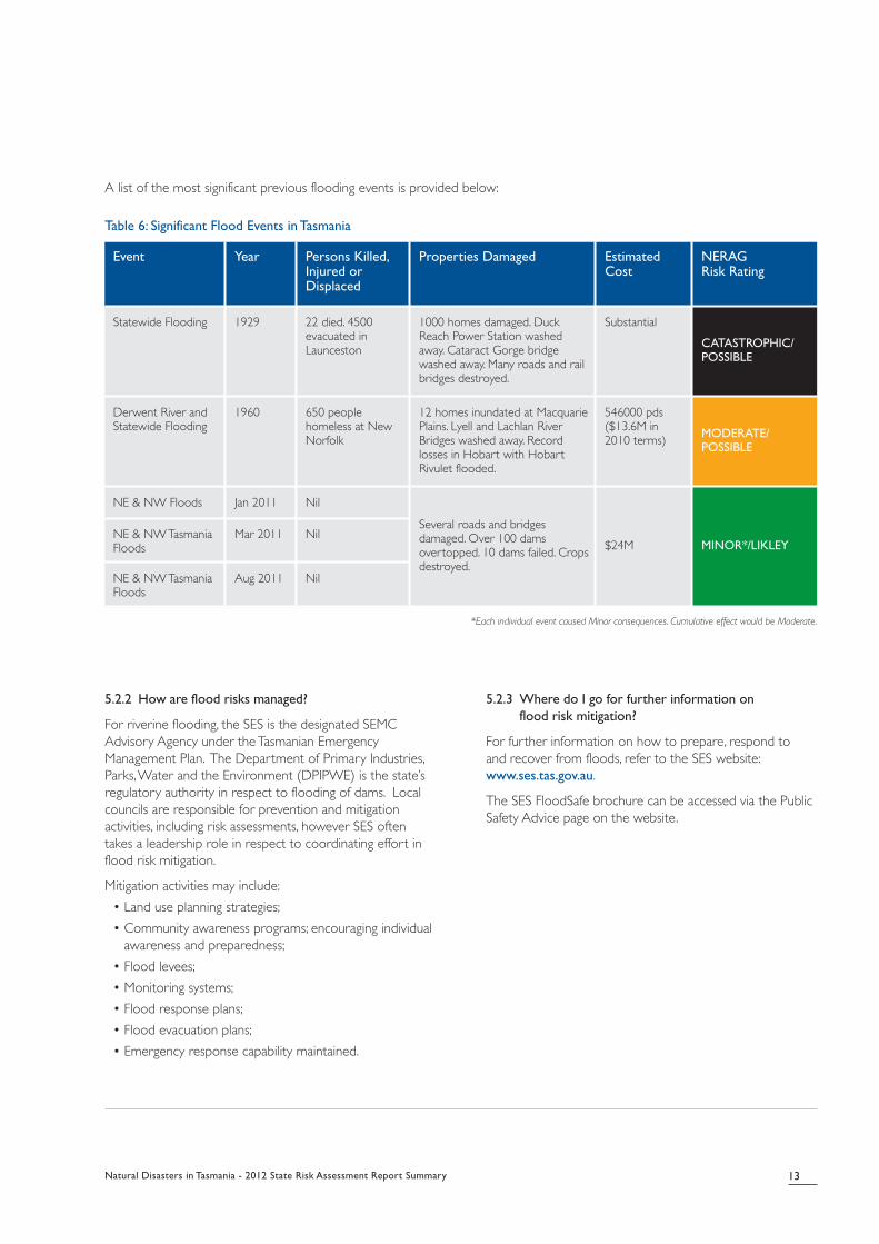
A list of the most significant previous flooding events is provided below:
Table 6: Significant Flood Events in Tasmania
*Each individual event caused Minor consequences. Cumulative effect would be Moderate.
5.2.2 How are flood risks managed?
For riverine flooding, the SES is the designated SEMCAdvisory Agency under the Tasmanian EmergencyManagement Plan. The Department of Primary Industries,Parks, Water and the Environment (DPIPWE) is the state’sregulatory authority in respect to flooding of dams. Localcouncils are responsible for prevention and mitigationactivities, including risk assessments, however SES oftentakes a leadership role in respect to coordinating effort inflood risk mitigation.
Mitigation activities may include:
• Land use planning strategies;
• Community awareness programs; encouraging individualawareness and preparedness;
• Flood levees;
• Monitoring systems;
• Flood response plans;
• Flood evacuation plans;
• Emergency response capability maintained.
5.2.3 Where do I go for further information on
flood risk mitigation?
For further information on how to prepare, respond to and recover from floods, refer to the SES website:www.ses.tas.gov.au.
The SES FloodSafe brochure can be accessed via the PublicSafety Advice page on the website.
Event Year Persons Killed,Injured orDisplaced
Properties Damaged EstimatedCost
NERAG Risk Rating
Statewide Flooding 1929 22 died. 4500evacuated inLaunceston
1000 homes damaged. DuckReach Power Station washedaway. Cataract Gorge bridgewashed away. Many roads and railbridges destroyed.
Substantial
CATASTROPHIC/POSSIBLE
Derwent River andStatewide Flooding
1960 650 peoplehomeless at NewNorfolk
12 homes inundated at MacquariePlains. Lyell and Lachlan RiverBridges washed away. Recordlosses in Hobart with HobartRivulet flooded.
546000 pds($13.6M in2010 terms) MODERATE/
POSSIBLE
NE & NW Floods Jan 2011 Nil
Several roads and bridgesdamaged. Over 100 damsovertopped. 10 dams failed. Cropsdestroyed.
$24M MINOR*/LIKLEYNE & NW TasmaniaFloods
Mar 2011 Nil
NE & NW TasmaniaFloods
Aug 2011 Nil

5.3 Storms
Tasmania lies in the ‘Roaring 40s’ belt of westerly airflow. Theprincipal characteristic of the Tasmanian climate is theinteraction between prevailing westerly wind and themountain ranges near the west coast and the centralplateau. The cycle of westerly winds is a key driver of theseasonal rainfall pattern, especially in the western and centralregions of Tasmania. These persistent westerly systems arerelated to features of the general circulation of theatmosphere in the southern hemisphere and mean Tasmaniais regularly subjected to storms and severe weather.
Storms affect all parts of Tasmania but different areas of thestate experience different storm scenarios. The north eastof the state is exposed to east coast lows as well aswesterly frontal systems and sometimes fronts that moveup from the south. The south east is reasonably protectedfrom the prevailing westerlies due to the mountain rangesin the west. The west and north west coasts areparticularly exposed to the prevailing storm weather.
Weather systems known as ‘East Coast Lows’ often bringintense rainfall and strong winds, however the state riskassessment identified the highest storm risk is likely to comefrom a broad-scale front moving in from the west bringingsevere thunderstorms with the potential for tornado winds.In such a scenario one to two deaths are likely, and therewould also be significant damage to properties.
Whilst power failure is common in storm events, thisgenerally causes short-term disruption only. Tasmania’senergy sector maintains excellent levels of redundancy toensure business continuity.
5.3.1 Previous significant storms
Storms are frequent but usually of low impact. The list ofrecent significant storm events includes:
• March 1980 (Hobart) - Several houses unroofed and 2houses totally destroyed. Gale force winds ruined 50%of the apple export crop.
• November, 1992 (Smithton) - Extensive damage to a dozenhomes and local infrastructure when a tornado cut inlandof Smithton. Wind gusts were recorded up to 280 kmh.
• December, 2001 (Launceston) - Tornadoes believed tobe present in the storm that damaged 114 houses inthe Launceston suburb of Summerhill. EmergencyServices workers from across the state were deployedto assist with temporary repairs. The total estimateddamage bill was $2M.
• June, 2003 (Hobart) - A young girl was tragically killedby a falling branch at Waterworks Reserve during agusty wind event in Hobart.
• April 2008 (Tasmania) - An overnight event thatwreaked havoc across Tasmania, damaging over 1000houses and leaving 65,000 customers without power forless than a day (1000 more than a day). This also caused:
- Short term closure of tourism sites. - Roads closed for short term. - Gusts recorded up to 177 kmh. - $2M in damage claims by RACT and similar rates
for other insurers. - $1M repair costs reported by Aurora.
• April 2009 (North Coast) - A line of severethunderstorms swept over North Coast producingseveral tornadoes, including wind gusts recorded atsecond highest ever - 195 km/h (Scottsdale). Somedamage to houses at Boat Harbour, near Wynyard. Theworst part of the storm missed major towns.
5.3.2 How are storm risks managed?
The Bureau of Meteorology maintains a national weatherwarning service. The Bureau has a well-established anddeveloped process for issuing storm and severe weatherwarnings that is used by the public and by various agencies.
SES is the designated SEMC Advisory Agency under theTasmanian Emergency Management Plan. Local councils areresponsible for prevention and mitigation activities, includingrisk assessments; however SES often take a leadership rolein respect to coordinating effort in storms risk mitigation.
Mitigation actions may include:• Land use planning• Building standards• Community awareness programs encouraging individual
awareness and preparedness • Maintenance of infrastructure• Protection of vulnerable critical infrastructure such as
power lines• Emergency response capability maintained
5.3.3 Where do I go for further information on
storm risk mitigation?
For further information about storms and how to preparefor, respond to and recover from storm events, refer to theSES StormSafe brochure, available on the Public SafetyAdvice page on the SES website: www.ses.tas.gov.au.
The Emergency Management Australia website also hasuseful information: www.em.gov.au.
14 Natural Disasters in Tasmania - 2012 State Risk Assessment Report Summary
Natural Disasters in Tasmania - 2012 State Risk Assessment Report Summary 15
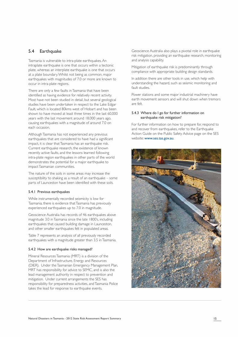
5.4 Earthquake
Tasmania is vulnerable to intra-plate earthquakes. Anintraplate earthquake is one that occurs within a tectonicplate, whereas an interplate earthquake is one that occursat a plate boundary. Whilst not being as common, majorearthquakes with magnitudes of 7.0 or more are known tooccur in intra-plate regions.
There are only a few faults in Tasmania that have beenidentified as having evidence for relatively recent activity.Most have not been studied in detail, but several geologicalstudies have been undertaken in respect to the Lake EdgarFault, which is located 80kms west of Hobart and has beenshown to have moved at least three times in the last 60,000years with the last movement around 18,000 years ago,causing earthquakes with a magnitude of around 7.0 oneach occasion.
Although Tasmania has not experienced any previousearthquakes that are considered to have had a significantimpact, it is clear that Tasmania has an earthquake risk.Current earthquake research, the existence of knownrecently active faults, and the lessons learned followingintra-plate region earthquakes in other parts of the worlddemonstrates the potential for a major earthquake toimpact Tasmanian communities.
The nature of the soils in some areas may increase thesusceptibility to shaking as a result of an earthquake – someparts of Launceston have been identified with these soils.
5.4.1 Previous earthquakes
While instrumentally recorded seismicity is low forTasmania, there is evidence that Tasmania has previouslyexperienced earthquakes up to 7.0 in magnitude.
Geoscience Australia has records of 46 earthquakes abovemagnitude 3.0 in Tasmania since the late 1800’s, includingearthquakes that caused building damage in Launceston,and other smaller earthquakes felt in populated areas.
Table 7 represents an analysis of all previously recordedearthquakes with a magnitude greater than 3.5 in Tasmania.
5.4.2 How are earthquake risks managed?
Mineral Resources Tasmania (MRT) is a division of theDepartment of Infrastructure, Energy and Resources(DIER). Under the Tasmanian Emergency Management Plan,MRT has responsibility for advice to SEMC, and is also thelead management authority in respect to prevention andmitigation. Under current arrangements the SES hasresponsibility for preparedness activities, and Tasmania Policetakes the lead for response to earthquake events.
Geoscience Australia also plays a pivotal role in earthquakerisk mitigation, providing an earthquake research, monitoringand analysis capability.
Mitigation of earthquake risk is predominantly throughcompliance with appropriate building design standards.
In addition there are other tools in use, which help withunderstanding the hazard, such as seismic monitoring andfault studies.
Power stations and some major industrial machinery haveearth movement sensors and will shut down when tremorsare felt.
5.4.3 Where do I go for further information on
earthquake risk mitigation?
For further information on how to prepare for, respond toand recover from earthquakes, refer to the EarthquakeAction Guide on the Public Safety Advice page on the SESwebsite: www.ses.tas.gov.au.
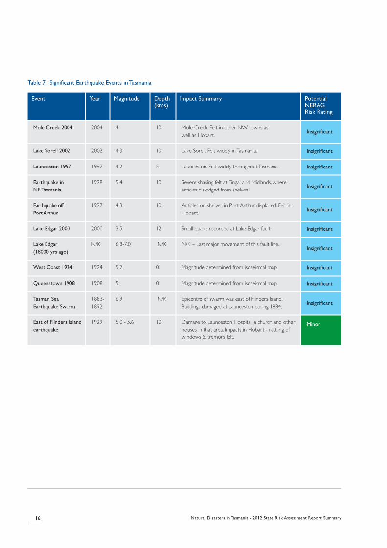
Table 7: Significant Earthquake Events in Tasmania
16 Natural Disasters in Tasmania - 2012 State Risk Assessment Report Summary
Event Year Magnitude Depth(kms)
Impact Summary Potential NERAG Risk Rating
Mole Creek 2004 2004 4 10 Mole Creek. Felt in other NW towns as well as Hobart.
Insignificant
Lake Sorell 2002 2002 4.3 10 Lake Sorell. Felt widely in Tasmania. Insignificant
Launceston 1997 1997 4.2 5 Launceston. Felt widely throughout Tasmania. Insignificant
Earthquake in
NE Tasmania
1928 5.4 10 Severe shaking felt at Fingal and Midlands, wherearticles dislodged from shelves.
Insignificant
Earthquake off
Port Arthur
1927 4.3 10 Articles on shelves in Port Arthur displaced. Felt inHobart.
Insignificant
Lake Edgar 2000 2000 3.5 12 Small quake recorded at Lake Edgar fault. Insignificant
Lake Edgar
(18000 yrs ago)
N/K 6.8-7.0 N/K N/K – Last major movement of this fault line.Insignificant
West Coast 1924 1924 5.2 0 Magnitude determined from isoseismal map. Insignificant
Queenstown 1908 1908 5 0 Magnitude determined from isoseismal map. Insignificant
Tasman Sea
Earthquake Swarm
1883-1892
6.9 N/K Epicentre of swarm was east of Flinders Island.Buildings damaged at Launceston during 1884.
Insignificant
East of Flinders Island
earthquake
1929 5.0 - 5.6 10 Damage to Launceston Hospital, a church and otherhouses in that area. Impacts in Hobart - rattling ofwindows & tremors felt.
Minor

Natural Disasters in Tasmania - 2012 State Risk Assessment Report Summary 17
5.5 Landslide
Landslide is generally defined as the movement of earth,rock or debris down a slope, and can also be referred to as‘slope failure’. Landslide research recognises five distincttypes of landslide that present a risk to communities.
The five main types, all known to occur in Tasmania, are asfollows:
• Slides (Shallow and Deep-Seated)
• Flows (Debris and Earth)
• Falls (Rock, Earth, Debris)
• Topples
• Spreads
Slides involve movement of material along recognisableshear surfaces or zones and are usually considered withintwo categories – shallow and deep-seated. Shallow slidesare more common than deep-seated and more frequentlyassociated with property damage. Larger deep-seatedslides are more easily recognised and are generally slow-moving with impacts realised over a longer term.
Flows refer to the movement of earth or debris in a fluidmotion and are generally associated with heavy rainfall. Aninitial shallow slide can develop into a rapid flow if there isexcess water on the ground. A debris flow occurs whenrocks and other debris mix with water and flow down a slopeuntil it meets some type of barrier or the slope flattens out.
Falls and topples involve a detachment and rapid movementof earth from a steep slope, are short in duration but cancause significant damage to anything located downslope ofthe earth movement location. Large rock falls cansometimes produce an avalanche effect.
The precise impact of a fall or topple will depend on whathappens to be in that location at the time of the event.These sorts of events generally present risk on steep slopesand cliffs, which are prevalent across the Tasmanian landscape.
A spread refers to a slope failure or displacement of earthon a relatively flat or level area of land. Spreads can occuranywhere across Tasmania but have been noticeable inseveral areas of the northwest landscape. Spreads aretypically very slow moving and so present a risk to propertybut not necessarily human life.
Where a slope failure event involves either a combinationof types or transition from one landslide type to another, itis referred to as a complex or transitional landslide event.An example is the 1872 event in Humphrey’s Rivulet,Glenorchy, where it is believed an initial debris flow createda debris dam in the rivulet, which then burst and created aflash flood comprising water, earth and debris.
These different types of landslide can occur anywhere acrossTasmania but have been particularly noticeable in several areasof the north-west landscape and the Tamar Valley, as well asspecific areas in and around Hobart, Launceston and St Helens.
5.5.1 Previous significant landslides
Mineral Resources Tasmania (MRT), a division of theDepartment of Infrastructure, Energy and Resources (DIER)has evidence of over 150 buildings in Tasmania that havebeen damaged or destroyed by landslide since the 1950’s.As shown in the below table, this figure includes 125residential premises, with the majority of the damagerecorded in the areas of Lawrence Vale (Launceston),Beauty Point, Rosetta and Taroona.
Limitations in the reporting and recording process forlandslide damage suggest the figures are probably higher. Inaddition to building damage, it is acknowledged that damageto infrastructure has occurred throughout Tasmania overmany years.
The majority of the landslide damage is caused by slow movingslides, which generally do not pose a threat to life. The types oflandslide that are most likely to pose a threat to life are thesudden impact, fast moving types: Sudden slides (shallow ordeep-seated), Debris flows or Earth flows, and Falls or Topples(rock, earth or debris). These are often associated with periodsof heavy rainfall and prolonged wet periods.
Large, sudden impact landslide events are relativelyuncommon in Tasmania, particularly in populated areas. Onesignificant example of such an event occurred in 1872 atHumphreys Rivulet, Glenorchy, where a large slide occurredon the flanks of Mt Arthur and the subsequent debris flowand flood travelled a total distance of about 8.5km, from MtArthur to the River Derwent.
5.5.2 How are landslide risks managed?
Mineral Resources Tasmania (MRT) has primaryresponsibility for management of landslide and othergeological hazards from a state research and policydevelopment perspective. Under the Tasmanian EmergencyManagement Plan, DIER is the designated SEMC AdvisoryAgency for landslides, with MRT specifically responsible forprevention and mitigation. Local council has responsibilityfor landslide preparedness predominantly as a result of itsrole in land use planning and development approval.
It is noted that landslide risk in Tasmania is generallymitigated through controls associated with land use anddevelopment. A major project is presently underway withinTasmania, which is reviewing and consolidating land useplanning schemes to improve consistency in the wayhazards such as landslide are mitigated throughdevelopment and use of land.
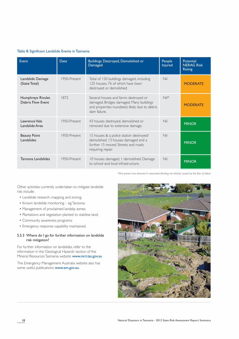
Table 8: Significant Landslide Events in Tasmania
*One person was drowned in associated flooding not directly caused by the flow of debris
Other activities currently undertaken to mitigate landsliderisk include:
• Landslide research, mapping and zoning;
• Known landslide monitoring – eg Taroona;
• Management of proclaimed landslip zones;
• Plantations and vegetation planted to stabilise land;
• Community awareness programs;
• Emergency response capability maintained.
5.5.3 Where do I go for further information on landslide
risk mitigation?
For further information on landslides, refer to theinformation in the ‘Geological Hazards’ section of theMineral Resources Tasmania website www.mrt.tas.gov.au
The Emergency Management Australia website also hassome useful publications: www.em.gov.au.
18 Natural Disasters in Tasmania - 2012 State Risk Assessment Report Summary
Event Date Buildings Destroyed, Demolished orDamaged
PeopleInjured
PotentialNERAG RiskRating
Landslide Damage
(State Total)
1950-Present Total of 150 buildings damaged, including 125 houses, 76 of which have been destroyed or demolished.
NilMODERATE
Humphreys Rivulet
Debris Flow Event
1872 Several houses and farms destroyed ordamaged. Bridges damaged. Many buildingsand properties inundated, likely due to debrisdam failure.
Nil*
MODERATE
Lawrence Vale
Landslide Area
1950-Present 43 houses destroyed, demolished orremoved due to extensive damage.
NilMINOR
Beauty Point
Landslides
1950-Present 15 houses & a police station destroyed/demolished. 13 houses damaged and afurther 15 moved. Streets and roadsrequiring repair.
Nil
MINOR
Taroona Landslides 1950-Present 10 houses damaged, 1 demolished. Damageto school and local infrastructure.
NilMINOR
Natural Disasters in Tasmania - 2012 State Risk Assessment Report Summary 19
5.6 Tsunami
A tsunami is a series of waves generated by suddenmovement of the sea floor, usually as a result of anearthquake. Volcanic eruptions, landslides and meteoritestrike can also cause tsunamis. Tsunamis are different towind-generated ocean waves, which cause movement ofwater near the surface. A tsunami involves movement ofwater from the sea floor to the surface.
In a deep ocean the wave height of a tsunami is rarelyhigher than 1 metre and it travels very fast, up to speeds of950 kmh. As the tsunami leaves deeper water andapproaches the shallower waters around a coastline, theleading edge slows down whilst the back keeps moving. Ineffect the water bunches up creating a wall of water thatcan be quite destructive. Harbours, bays and lagoons cancreate a focusing effect and amplify the effect of thetsunami.
Tsunami risk is generally associated with large earthquakesthat primarily occur where two tectonic plates movetowards each other and one is pushed downward beneaththe other (this is called subduction). While Tasmania hasnot been significantly impacted by a tsunami in its recenthistory, its proximity to the subduction zones that stretchfrom Papua New Guinea to New Zealand give rise to thepotential for tsunami activity, particularly along the eastcoast.
Research into tsunami activity in Tasmania indicates thatunusual wave activity has been detected around thecoastline on at least sixteen occasions since 1852, and thatthis activity is likely to have been associated with a tsunamievent. Geoscience Australia has identified the greatesttsunami risk to Tasmania is likely to be from the PuysegurTrench area off the south coast of New Zealand, an activeregion for earthquakes.
Earthquakes occur in the Puysegur Trench quite frequentlybut do not always result in a tsunami. If a tsunami were tobe generated from this location it would approach Tasmaniaacross the Tasman Sea. The extent of inundation woulddepend on the size of the earthquake, the size of thetsunami it generated and several other factors including theshape of the seabed and topography of the coastline.
5.6.1 Previous significant tsunamis
While research is continuing with the aim of determiningthe extent of Tasmania’s historical exposure to tsunami,Tasmania has not experienced a significant tsunami in recenttimes. Due to the lack of historical records, unusual waveactivity and tide gauge recordings are used to reflecttsunami history in the table over page.
5.6.2 How are tsunami risks managed?
SES and the broader Department of Police and EmergencyManagement have responsibility for tsunami mitigation,preparedness and response under present emergencymanagement arrangements.
The Joint Australian Tsunami Warning Centre (JATWC) hasresponsibility for issuing tsunami warnings. The standarddefined for the Australian Tsunami Warning System is toprovide a minimum of 90 minutes warning to Australiancoastal communities for tsunami generated earthquakesoccurring on tectonic plate boundaries in the Indian, Pacificand Southern Oceans. The JATWC is able to issue initialtsunami warning bulletins within 30 minutes of the origintime of earthquakes within the Australian region.
It should be noted that the Puysegur Trench has theshortest tsunami arrival time under the JATWC estimates.It is presently estimated that it would take a tsunami fromthat zone approximately 2 hours from the time of theearthquake to arrive on the coastline of Tasmania. This givesDPEM and other emergency services approximately 90minutes to respond to the initial threat.
Based on existing modelling, it is recognised that anyinundation to occur would be in populated areas that havealready been identified as susceptible to storm surge andsea level rise.
Mitigation activities may include:
• Tsunami inundation modelling
• Tsunami detection buoys between Tasmania and NewZealand;
• Tsunami monitoring and warning service;
• Seismic monitoring
• Community awareness programs
5.6.3 Where do I go for further information on tsunami
risk mitigation?
People in low lying coastal areas are at greater risk oftsunami and other coastal inundation events.Understanding and awareness of how to plan, prepare forand respond to an event can reduce its impact.
For further information, refer to the SES website:www.ses.tas.gov.au
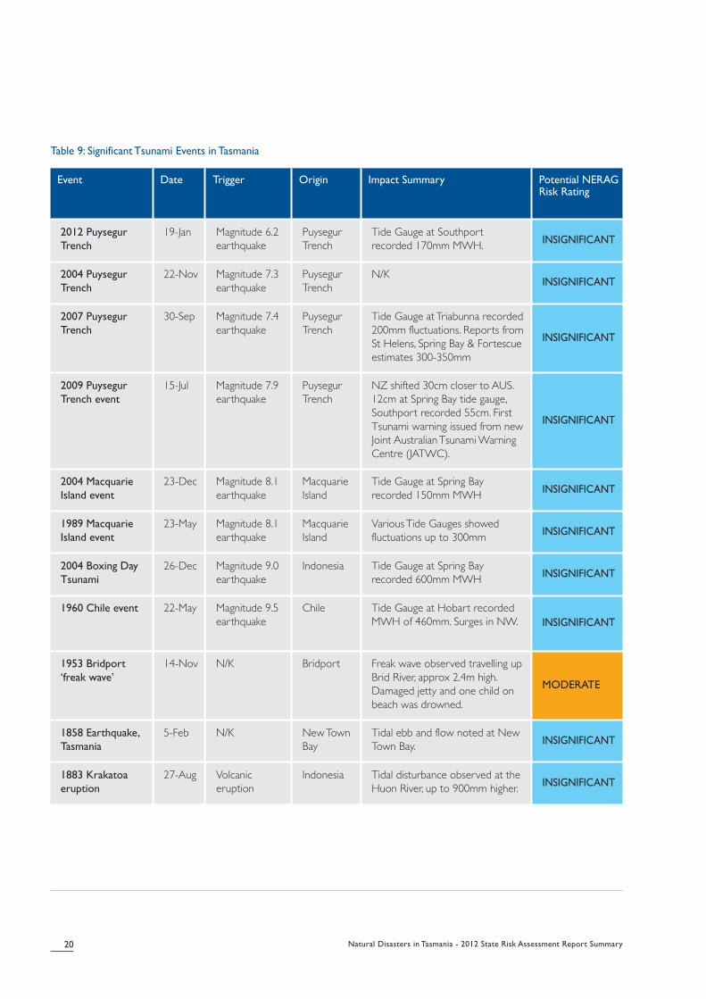
Table 9: Significant Tsunami Events in Tasmania
20 Natural Disasters in Tasmania - 2012 State Risk Assessment Report Summary
Event Date Trigger Origin Impact Summary Potential NERAGRisk Rating
2012 Puysegur
Trench
19-Jan Magnitude 6.2earthquake
PuysegurTrench
Tide Gauge at Southportrecorded 170mm MWH. INSIGNIFICANT
2004 Puysegur
Trench
22-Nov Magnitude 7.3earthquake
PuysegurTrench
N/KINSIGNIFICANT
2007 Puysegur
Trench
30-Sep Magnitude 7.4earthquake
PuysegurTrench
Tide Gauge at Triabunna recorded200mm fluctuations. Reports fromSt Helens, Spring Bay & Fortescueestimates 300-350mm
INSIGNIFICANT
2009 Puysegur
Trench event
15-Jul Magnitude 7.9earthquake
PuysegurTrench
NZ shifted 30cm closer to AUS.12cm at Spring Bay tide gauge,Southport recorded 55cm. FirstTsunami warning issued from newJoint Australian Tsunami WarningCentre (JATWC).
INSIGNIFICANT
2004 Macquarie
Island event
23-Dec Magnitude 8.1earthquake
MacquarieIsland
Tide Gauge at Spring Bayrecorded 150mm MWH INSIGNIFICANT
1989 Macquarie
Island event
23-May Magnitude 8.1earthquake
MacquarieIsland
Various Tide Gauges showedfluctuations up to 300mm INSIGNIFICANT
2004 Boxing Day
Tsunami
26-Dec Magnitude 9.0earthquake
Indonesia Tide Gauge at Spring Bayrecorded 600mm MWH INSIGNIFICANT
1960 Chile event 22-May Magnitude 9.5earthquake
Chile Tide Gauge at Hobart recordedMWH of 460mm. Surges in NW. INSIGNIFICANT
1953 Bridport
‘freak wave’
14-Nov N/K Bridport Freak wave observed travelling upBrid River, approx 2.4m high.Damaged jetty and one child onbeach was drowned.
MODERATE
1858 Earthquake,
Tasmania
5-Feb N/K New TownBay
Tidal ebb and flow noted at NewTown Bay. INSIGNIFICANT
1883 Krakatoa
eruption
27-Aug Volcaniceruption
Indonesia Tidal disturbance observed at theHuon River, up to 900mm higher. INSIGNIFICANT

Natural Disasters in Tasmania - 2012 State Risk Assessment Report Summary 21
There are many other hazards that impact Tasmania fromtime to time. Information on all of Tasmania’s hazardsemergency management arrangements can be found withinthe Tasmanian Emergency Management Plan, available onthe Publications page on the SES website:www.ses.tas.gov.au
For general advice on hazards and risk awareness, please visit the Emergency Management Australia website:www.em.gov.au.
Natural disasters will continue to occur. How we cope asindividuals and governments is reliant upon our knowledgeof these hazards and the impacts that they may have. Bysystematically working through a risk assessment andmanagement process we can understand the nature andextent of the risk and therefore have some control overtheir impacts.
For governments, this better understanding of risk can helpin prioritising the use of limited funds and resources in themost effective way to lessen the consequences and helpbuild resilience.
For individuals, understanding the nature of the hazards andthe potential impacts will allow them to share in theresponsibility for preparing for, responding to andrecovering from disasters.
Disaster resilience is a joint responsibility of government,business, the non-government sector and individuals. Byworking together with a shared sense of responsibility andfocus our efforts will be far more effective.
6. Other hazards 7. Conclusion

. . . . . . . . . . . . . . . . . . . . . . . . . . . . . . . . . . . . . . . . . . . . . . . . . . . . . . . . . . . . . . . . . . . . . . . . . . . . . . . . . . . . . . . . . . . . . . . . . . . . . . . . . . . . . . . . . . . . . . . . . . . . . . . . . . . . . . . . . . . . . . . . . . . . . . . . . . . . . . . . . . . . . . . . . . . . . . . . . . . . . . . . . . . . . . . . . . . . . . . . . . . . . . . . . . . . . . . . . . . . . . . . . . . . . . . . . . . . . . . . . . . . . . . . . . . . . . . . . . . . . . . . . . . . . . . . . . . . . . . . . . . . . . . . . . . .
. . . . . . . . . . . . . . . . . . . . . . . . . . . . . . . . . . . . . . . . . . . . . . . . . . . . . . . . . . . . . . . . . . . . . . . . . . . . . . . . . . . . . . . . . . . . . . . . . . . . . . . . . . . . . . . . . . . . . . . . . . . . . . . . . . . . . . . . . . . . . . . . . . . . . . . . . . . . . . . . . . . . . . . . . . . . . . . . . . . . . . . . . . . . . . . . . . . . . . . . . . . . . . . . . . . . . . . . . . . . . . . . . . . . . . . . . . . . . . . . . . . . . . . . . . . . . . . . . . . . . . . . . . . . . . . . . . . . . . . . . . . . . . . . . . . .
. . . . . . . . . . . . . . . . . . . . . . . . . . . . . . . . . . . . . . . . . . . . . . . . . . . . . . . . . . . . . . . . . . . . . . . . . . . . . . . . . . . . . . . . . . . . . . . . . . . . . . . . . . . . . . . . . . . . . . . . . . . . . . . . . . . . . . . . . . . . . . . . . . . . . . . . . . . . . . . . . . . . . . . . . . . . . . . . . . . . . . . . . . . . . . . . . . . . . . . . . . . . . . . . . . . . . . . . . . . . . . . . . . . . . . . . . . . . . . . . . . . . . . . . . . . . . . . . . . . . . . . . . . . . . . . . . . . . . . . . . . . . . . . . . . . .
. . . . . . . . . . . . . . . . . . . . . . . . . . . . . . . . . . . . . . . . . . . . . . . . . . . . . . . . . . . . . . . . . . . . . . . . . . . . . . . . . . . . . . . . . . . . . . . . . . . . . . . . . . . . . . . . . . . . . . . . . . . . . . . . . . . . . . . . . . . . . . . . . . . . . . . . . . . . . . . . . . . . . . . . . . . . . . . . . . . . . . . . . . . . . . . . . . . . . . . . . . . . . . . . . . . . . . . . . . . . . . . . . . . . . . . . . . . . . . . . . . . . . . . . . . . . . . . . . . . . . . . . . . . . . . . . . . . . . . . . . . . . . . . . . . . .
. . . . . . . . . . . . . . . . . . . . . . . . . . . . . . . . . . . . . . . . . . . . . . . . . . . . . . . . . . . . . . . . . . . . . . . . . . . . . . . . . . . . . . . . . . . . . . . . . . . . . . . . . . . . . . . . . . . . . . . . . . . . . . . . . . . . . . . . . . . . . . . . . . . . . . . . . . . . . . . . . . . . . . . . . . . . . . . . . . . . . . . . . . . . . . . . . . . . . . . . . . . . . . . . . . . . . . . . . . . . . . . . . . . . . . . . . . . . . . . . . . . . . . . . . . . . . . . . . . . . . . . . . . . . . . . . . . . . . . . . . . . . . . . . . . . .
. . . . . . . . . . . . . . . . . . . . . . . . . . . . . . . . . . . . . . . . . . . . . . . . . . . . . . . . . . . . . . . . . . . . . . . . . . . . . . . . . . . . . . . . . . . . . . . . . . . . . . . . . . . . . . . . . . . . . . . . . . . . . . . . . . . . . . . . . . . . . . . . . . . . . . . . . . . . . . . . . . . . . . . . . . . . . . . . . . . . . . . . . . . . . . . . . . . . . . . . . . . . . . . . . . . . . . . . . . . . . . . . . . . . . . . . . . . . . . . . . . . . . . . . . . . . . . . . . . . . . . . . . . . . . . . . . . . . . . . . . . . . . . . . . . . .
. . . . . . . . . . . . . . . . . . . . . . . . . . . . . . . . . . . . . . . . . . . . . . . . . . . . . . . . . . . . . . . . . . . . . . . . . . . . . . . . . . . . . . . . . . . . . . . . . . . . . . . . . . . . . . . . . . . . . . . . . . . . . . . . . . . . . . . . . . . . . . . . . . . . . . . . . . . . . . . . . . . . . . . . . . . . . . . . . . . . . . . . . . . . . . . . . . . . . . . . . . . . . . . . . . . . . . . . . . . . . . . . . . . . . . . . . . . . . . . . . . . . . . . . . . . . . . . . . . . . . . . . . . . . . . . . . . . . . . . . . . . . . . . . . . . .
. . . . . . . . . . . . . . . . . . . . . . . . . . . . . . . . . . . . . . . . . . . . . . . . . . . . . . . . . . . . . . . . . . . . . . . . . . . . . . . . . . . . . . . . . . . . . . . . . . . . . . . . . . . . . . . . . . . . . . . . . . . . . . . . . . . . . . . . . . . . . . . . . . . . . . . . . . . . . . . . . . . . . . . . . . . . . . . . . . . . . . . . . . . . . . . . . . . . . . . . . . . . . . . . . . . . . . . . . . . . . . . . . . . . . . . . . . . . . . . . . . . . . . . . . . . . . . . . . . . . . . . . . . . . . . . . . . . . . . . . . . . . . . . . . . . .
. . . . . . . . . . . . . . . . . . . . . . . . . . . . . . . . . . . . . . . . . . . . . . . . . . . . . . . . . . . . . . . . . . . . . . . . . . . . . . . . . . . . . . . . . . . . . . . . . . . . . . . . . . . . . . . . . . . . . . . . . . . . . . . . . . . . . . . . . . . . . . . . . . . . . . . . . . . . . . . . . . . . . . . . . . . . . . . . . . . . . . . . . . . . . . . . . . . . . . . . . . . . . . . . . . . . . . . . . . . . . . . . . . . . . . . . . . . . . . . . . . . . . . . . . . . . . . . . . . . . . . . . . . . . . . . . . . . . . . . . . . . . . . . . . . . .
. . . . . . . . . . . . . . . . . . . . . . . . . . . . . . . . . . . . . . . . . . . . . . . . . . . . . . . . . . . . . . . . . . . . . . . . . . . . . . . . . . . . . . . . . . . . . . . . . . . . . . . . . . . . . . . . . . . . . . . . . . . . . . . . . . . . . . . . . . . . . . . . . . . . . . . . . . . . . . . . . . . . . . . . . . . . . . . . . . . . . . . . . . . . . . . . . . . . . . . . . . . . . . . . . . . . . . . . . . . . . . . . . . . . . . . . . . . . . . . . . . . . . . . . . . . . . . . . . . . . . . . . . . . . . . . . . . . . . . . . . . . . . . . . . . . .
. . . . . . . . . . . . . . . . . . . . . . . . . . . . . . . . . . . . . . . . . . . . . . . . . . . . . . . . . . . . . . . . . . . . . . . . . . . . . . . . . . . . . . . . . . . . . . . . . . . . . . . . . . . . . . . . . . . . . . . . . . . . . . . . . . . . . . . . . . . . . . . . . . . . . . . . . . . . . . . . . . . . . . . . . . . . . . . . . . . . . . . . . . . . . . . . . . . . . . . . . . . . . . . . . . . . . . . . . . . . . . . . . . . . . . . . . . . . . . . . . . . . . . . . . . . . . . . . . . . . . . . . . . . . . . . . . . . . . . . . . . . . . . . . . . . .
. . . . . . . . . . . . . . . . . . . . . . . . . . . . . . . . . . . . . . . . . . . . . . . . . . . . . . . . . . . . . . . . . . . . . . . . . . . . . . . . . . . . . . . . . . . . . . . . . . . . . . . . . . . . . . . . . . . . . . . . . . . . . . . . . . . . . . . . . . . . . . . . . . . . . . . . . . . . . . . . . . . . . . . . . . . . . . . . . . . . . . . . . . . . . . . . . . . . . . . . . . . . . . . . . . . . . . . . . . . . . . . . . . . . . . . . . . . . . . . . . . . . . . . . . . . . . . . . . . . . . . . . . . . . . . . . . . . . . . . . . . . . . . . . . . . .
. . . . . . . . . . . . . . . . . . . . . . . . . . . . . . . . . . . . . . . . . . . . . . . . . . . . . . . . . . . . . . . . . . . . . . . . . . . . . . . . . . . . . . . . . . . . . . . . . . . . . . . . . . . . . . . . . . . . . . . . . . . . . . . . . . . . . . . . . . . . . . . . . . . . . . . . . . . . . . . . . . . . . . . . . . . . . . . . . . . . . . . . . . . . . . . . . . . . . . . . . . . . . . . . . . . . . . . . . . . . . . . . . . . . . . . . . . . . . . . . . . . . . . . . . . . . . . . . . . . . . . . . . . . . . . . . . . . . . . . . . . . . . . . . . . . .
. . . . . . . . . . . . . . . . . . . . . . . . . . . . . . . . . . . . . . . . . . . . . . . . . . . . . . . . . . . . . . . . . . . . . . . . . . . . . . . . . . . . . . . . . . . . . . . . . . . . . . . . . . . . . . . . . . . . . . . . . . . . . . . . . . . . . . . . . . . . . . . . . . . . . . . . . . . . . . . . . . . . . . . . . . . . . . . . . . . . . . . . . . . . . . . . . . . . . . . . . . . . . . . . . . . . . . . . . . . . . . . . . . . . . . . . . . . . . . . . . . . . . . . . . . . . . . . . . . . . . . . . . . . . . . . . . . . . . . . . . . . . . . . . . . . .
. . . . . . . . . . . . . . . . . . . . . . . . . . . . . . . . . . . . . . . . . . . . . . . . . . . . . . . . . . . . . . . . . . . . . . . . . . . . . . . . . . . . . . . . . . . . . . . . . . . . . . . . . . . . . . . . . . . . . . . . . . . . . . . . . . . . . . . . . . . . . . . . . . . . . . . . . . . . . . . . . . . . . . . . . . . . . . . . . . . . . . . . . . . . . . . . . . . . . . . . . . . . . . . . . . . . . . . . . . . . . . . . . . . . . . . . . . . . . . . . . . . . . . . . . . . . . . . . . . . . . . . . . . . . . . . . . . . . . . . . . . . . . . . . . . . .
. . . . . . . . . . . . . . . . . . . . . . . . . . . . . . . . . . . . . . . . . . . . . . . . . . . . . . . . . . . . . . . . . . . . . . . . . . . . . . . . . . . . . . . . . . . . . . . . . . . . . . . . . . . . . . . . . . . . . . . . . . . . . . . . . . . . . . . . . . . . . . . . . . . . . . . . . . . . . . . . . . . . . . . . . . . . . . . . . . . . . . . . . . . . . . . . . . . . . . . . . . . . . . . . . . . . . . . . . . . . . . . . . . . . . . . . . . . . . . . . . . . . . . . . . . . . . . . . . . . . . . . . . . . . . . . . . . . . . . . . . . . . . . . . . . . .
. . . . . . . . . . . . . . . . . . . . . . . . . . . . . . . . . . . . . . . . . . . . . . . . . . . . . . . . . . . . . . . . . . . . . . . . . . . . . . . . . . . . . . . . . . . . . . . . . . . . . . . . . . . . . . . . . . . . . . . . . . . . . . . . . . . . . . . . . . . . . . . . . . . . . . . . . . . . . . . . . . . . . . . . . . . . . . . . . . . . . . . . . . . . . . . . . . . . . . . . . . . . . . . . . . . . . . . . . . . . . . . . . . . . . . . . . . . . . . . . . . . . . . . . . . . . . . . . . . . . . . . . . . . . . . . . . . . . . . . . . . . . . . . . . . . .
. . . . . . . . . . . . . . . . . . . . . . . . . . . . . . . . . . . . . . . . . . . . . . . . . . . . . . . . . . . . . . . . . . . . . . . . . . . . . . . . . . . . . . . . . . . . . . . . . . . . . . . . . . . . . . . . . . . . . . . . . . . . . . . . . . . . . . . . . . . . . . . . . . . . . . . . . . . . . . . . . . . . . . . . . . . . . . . . . . . . . . . . . . . . . . . . . . . . . . . . . . . . . . . . . . . . . . . . . . . . . . . . . . . . . . . . . . . . . . . . . . . . . . . . . . . . . . . . . . . . . . . . . . . . . . . . . . . . . . . . . . . . . . . . . . . .
. . . . . . . . . . . . . . . . . . . . . . . . . . . . . . . . . . . . . . . . . . . . . . . . . . . . . . . . . . . . . . . . . . . . . . . . . . . . . . . . . . . . . . . . . . . . . . . . . . . . . . . . . . . . . . . . . . . . . . . . . . . . . . . . . . . . . . . . . . . . . . . . . . . . . . . . . . . . . . . . . . . . . . . . . . . . . . . . . . . . . . . . . . . . . . . . . . . . . . . . . . . . . . . . . . . . . . . . . . . . . . . . . . . . . . . . . . . . . . . . . . . . . . . . . . . . . . . . . . . . . . . . . . . . . . . . . . . . . . . . . . . . . . . . . . . .
. . . . . . . . . . . . . . . . . . . . . . . . . . . . . . . . . . . . . . . . . . . . . . . . . . . . . . . . . . . . . . . . . . . . . . . . . . . . . . . . . . . . . . . . . . . . . . . . . . . . . . . . . . . . . . . . . . . . . . . . . . . . . . . . . . . . . . . . . . . . . . . . . . . . . . . . . . . . . . . . . . . . . . . . . . . . . . . . . . . . . . . . . . . . . . . . . . . . . . . . . . . . . . . . . . . . . . . . . . . . . . . . . . . . . . . . . . . . . . . . . . . . . . . . . . . . . . . . . . . . . . . . . . . . . . . . . . . . . . . . . . . . . . . . . . . .
. . . . . . . . . . . . . . . . . . . . . . . . . . . . . . . . . . . . . . . . . . . . . . . . . . . . . . . . . . . . . . . . . . . . . . . . . . . . . . . . . . . . . . . . . . . . . . . . . . . . . . . . . . . . . . . . . . . . . . . . . . . . . . . . . . . . . . . . . . . . . . . . . . . . . . . . . . . . . . . . . . . . . . . . . . . . . . . . . . . . . . . . . . . . . . . . . . . . . . . . . . . . . . . . . . . . . . . . . . . . . . . . . . . . . . . . . . . . . . . . . . . . . . . . . . . . . . . . . . . . . . . . . . . . . . . . . . . . . . . . . . . . . . . . . . . .
. . . . . . . . . . . . . . . . . . . . . . . . . . . . . . . . . . . . . . . . . . . . . . . . . . . . . . . . . . . . . . . . . . . . . . . . . . . . . . . . . . . . . . . . . . . . . . . . . . . . . . . . . . . . . . . . . . . . . . . . . . . . . . . . . . . . . . . . . . . . . . . . . . . . . . . . . . . . . . . . . . . . . . . . . . . . . . . . . . . . . . . . . . . . . . . . . . . . . . . . . . . . . . . . . . . . . . . . . . . . . . . . . . . . . . . . . . . . . . . . . . . . . . . . . . . . . . . . . . . . . . . . . . . . . . . . . . . . . . . . . . . . . . . . . . . .
. . . . . . . . . . . . . . . . . . . . . . . . . . . . . . . . . . . . . . . . . . . . . . . . . . . . . . . . . . . . . . . . . . . . . . . . . . . . . . . . . . . . . . . . . . . . . . . . . . . . . . . . . . . . . . . . . . . . . . . . . . . . . . . . . . . . . . . . . . . . . . . . . . . . . . . . . . . . . . . . . . . . . . . . . . . . . . . . . . . . . . . . . . . . . . . . . . . . . . . . . . . . . . . . . . . . . . . . . . . . . . . . . . . . . . . . . . . . . . . . . . . . . . . . . . . . . . . . . . . . . . . . . . . . . . . . . . . . . . . . . . . . . . . . . . . .
. . . . . . . . . . . . . . . . . . . . . . . . . . . . . . . . . . . . . . . . . . . . . . . . . . . . . . . . . . . . . . . . . . . . . . . . . . . . . . . . . . . . . . . . . . . . . . . . . . . . . . . . . . . . . . . . . . . . . . . . . . . . . . . . . . . . . . . . . . . . . . . . . . . . . . . . . . . . . . . . . . . . . . . . . . . . . . . . . . . . . . . . . . . . . . . . . . . . . . . . . . . . . . . . . . . . . . . . . . . . . . . . . . . . . . . . . . . . . . . . . . . . . . . . . . . . . . . . . . . . . . . . . . . . . . . . . . . . . . . . . . . . . . . . . . . .
. . . . . . . . . . . . . . . . . . . . . . . . . . . . . . . . . . . . . . . . . . . . . . . . . . . . . . . . . . . . . . . . . . . . . . . . . . . . . . . . . . . . . . . . . . . . . . . . . . . . . . . . . . . . . . . . . . . . . . . . . . . . . . . . . . . . . . . . . . . . . . . . . . . . . . . . . . . . . . . . . . . . . . . . . . . . . . . . . . . . . . . . . . . . . . . . . . . . . . . . . . . . . . . . . . . . . . . . . . . . . . . . . . . . . . . . . . . . . . . . . . . . . . . . . . . . . . . . . . . . . . . . . . . . . . . . . . . . . . . . . . . . . . . . . . . .
. . . . . . . . . . . . . . . . . . . . . . . . . . . . . . . . . . . . . . . . . . . . . . . . . . . . . . . . . . . . . . . . . . . . . . . . . . . . . . . . . . . . . . . . . . . . . . . . . . . . . . . . . . . . . . . . . . . . . . . . . . . . . . . . . . . . . . . . . . . . . . . . . . . . . . . . . . . . . . . . . . . . . . . . . . . . . . . . . . . . . . . . . . . . . . . . . . . . . . . . . . . . . . . . . . . . . . . . . . . . . . . . . . . . . . . . . . . . . . . . . . . . . . . . . . . . . . . . . . . . . . . . . . . . . . . . . . . . . . . . . . . . . . . . . . . .
. . . . . . . . . . . . . . . . . . . . . . . . . . . . . . . . . . . . . . . . . . . . . . . . . . . . . . . . . . . . . . . . . . . . . . . . . . . . . . . . . . . . . . . . . . . . . . . . . . . . . . . . . . . . . . . . . . . . . . . . . . . . . . . . . . . . . . . . . . . . . . . . . . . . . . . . . . . . . . . . . . . . . . . . . . . . . . . . . . . . . . . . . . . . . . . . . . . . . . . . . . . . . . . . . . . . . . . . . . . . . . . . . . . . . . . . . . . . . . . . . . . . . . . . . . . . . . . . . . . . . . . . . . . . . . . . . . . . . . . . . . . . . . . . . . . .
22 Natural Disasters in Tasmania - 2012 State Risk Assessment Report Summary
Notes