Native vegetation information - Department of Environment ...
9
www.dse.vic.gov.au Native vegetation information Overview of native vegetation spatial datasets Information sheet No. 1 A Victorian Government Initiative Introduction An important goal of the Department of Sustainability and Environment (DSE) in relation to managing native vegetation has been to develop statewide native vegetation datasets to at least a scale of 1:100,000 and in some areas 1:25,000. This needed to cover both public and private land using Ecological Vegetation Classes (EVCs) that are ecologically meaningful and useful for natural resource managers at the landscape scale. The Biodiversity and Ecosystem Services division (BES) of DSE manages a series of these native vegetation datasets describing the spatial extent of native vegetation types pre- clearing (pre-1750) and extant (ie. current extent of EVCs). Mapping of the entire State by DSE has now been completed and our activity will focus on updating and improving the quality of the existing native vegetation spatial and typology datasets. To date, the majority of this data has been collected through aerial photograph interpretation, biophysical data and ground truthing sites, on a project by project basis over a number of years. BES is now using satellite imagery more extensively in conjunction with other environmental spatial data to model native vegetation across Victoria more accurately and at more regular intervals. It has recently completed a number of new and revised datasets, including a model of the extent of native vegetation across Victoria (without EVC type) together with a Statewide model of native vegetation quality. The methodology for generating the current extent of EVCs will also change, with the current extent of EVCs in the future being generated from the combination of pre-1750 EVCs and the native vegetation extent datasets. There will also be standardised symbology sets available (ie. EVC colour symbols displayed on map legends) which should be used when creating any EVC map. The naming of all native vegetation datasets has also changed, to mark the change in methodology and to group the datasets in a more consistent manner. The new and old datasets will co-exist until June/July 2008 and source data used in the original mapping of the current extent of EVCs will be retained in a restricted access library in the Corporate Spatial Data Library (CSDL). Naming of Native Vegetation Datasets Dataset Names will now follow a standard format, ie. NV {Year}_{attribute}, where: • {NV} stands for Native Vegetation • {Year} is the year reflected by the data ie 1750 is pre clearing and 2005 is the year of the modelled current extent, the next year may be 2010 or 2015, depending on monitoring frequency • {attribute} is the type of information stored in the dataset (ie. EVC, EVCBCS, QUAL etc.) 2007 Dataset Equivalent Old Dataset Dataset Name Brief Description NV1750_EVC EVC1750_CMP Native Vegetation, 1750 – Ecological Vegetation Classes Master dataset for EVC typology and distribution. Future map edits will occur in this dataset, Includes data capture project, edit change information NV1750_EVCBCS EVC_1750BCS Native Vegetation, 1750 – Bioregional Conservation Status of EVCs Derived dataset, combining bioregions and pre- 1750 EVCs. Includes bioregional conservation status (BCS) and geographic occurrence (GO). NV2005_EXTENT NVE_2005 Native Vegetation, 2005 – Extent Modelled native vegetation extent – includes highly likely grassy, woody and structurally modified native vegetation. NV2005_EVCBCS EVC_BCS100 Native Vegetation, 2005 – Bioregional Conservation Status of EVCs Derived dataset, combining bioregions, pre-1750 EVCs and modelled current extent. Includes bioregional conservation status (BCS) and geographic occurrence (GO). NV2005_QUAL Not applicable Native Vegetation, 2005 - Quality Modelled native vegetation quality - includes Site Condition and Landscape Context.
Transcript of Native vegetation information - Department of Environment ...

www.dse.vic.gov.au
Native vegetation information Overview of native vegetation spatial datasets Information sheet No. 1
A Victorian Government
Initiative
Introduction An important goal of the Department of Sustainability and Environment (DSE) in relation to managing native vegetation has been to develop statewide native vegetation datasets to at least a scale of 1:100,000 and in some areas 1:25,000. This needed to cover both public and private land using Ecological Vegetation Classes (EVCs) that are ecologically meaningful and useful for natural resource managers at the landscape scale. The Biodiversity and Ecosystem Services division (BES) of DSE manages a series of these native vegetation datasets describing the spatial extent of native vegetation types pre-clearing (pre-1750) and extant (ie. current extent of EVCs). Mapping of the entire State by DSE has now been completed and our activity will focus on updating and improving the quality of the existing native vegetation spatial and typology datasets. To date, the majority of this data has been collected through aerial photograph interpretation, biophysical data and ground truthing sites, on a project by project basis over a number of years.
BES is now using satellite imagery more extensively in conjunction with other environmental spatial data to model native vegetation across Victoria more accurately and at more regular intervals. It has recently completed a number of new and revised datasets, including a model of the extent of native vegetation across Victoria (without EVC type) together with a
Statewide model of native vegetation quality.
The methodology for generating the current extent of EVCs will also change, with the current extent of EVCs in the future being generated from the combination of pre-1750 EVCs and the native vegetation extent datasets. There will also be standardised symbology sets available (ie. EVC colour symbols displayed on map legends) which should be used when creating any EVC map.
The naming of all native vegetation datasets has also changed, to mark the change in methodology and to group the datasets in a more consistent manner. The new and old datasets will co-exist until June/July 2008 and source data used in the original mapping of the current extent of EVCs will be retained in a restricted access library in the Corporate Spatial Data Library (CSDL).
Naming of Native Vegetation Datasets Dataset Names will now follow a standard format, ie.
NV {Year}_{attribute}, where:
• {NV} stands for Native Vegetation
• {Year} is the year reflected by the data ie 1750 is pre clearing and 2005 is the year of the modelled current extent, the next year may be 2010 or 2015, depending on monitoring frequency
• {attribute} is the type of information stored in the dataset (ie. EVC, EVCBCS, QUAL etc.)
2007 Dataset Equivalent Old Dataset Dataset Name Brief Description
NV1750_EVC EVC1750_CMP Native Vegetation, 1750 – Ecological Vegetation Classes
Master dataset for EVC typology and distribution. Future map edits will occur in this dataset, Includes data capture project, edit change information
NV1750_EVCBCS EVC_1750BCS Native Vegetation, 1750 – Bioregional Conservation Status of EVCs
Derived dataset, combining bioregions and pre-1750 EVCs. Includes bioregional conservation status (BCS) and geographic occurrence (GO).
NV2005_EXTENT NVE_2005 Native Vegetation, 2005 – Extent Modelled native vegetation extent – includes highly likely grassy, woody and structurally modified native vegetation.
NV2005_EVCBCS EVC_BCS100 Native Vegetation, 2005 – Bioregional Conservation Status of EVCs
Derived dataset, combining bioregions, pre-1750 EVCs and modelled current extent. Includes bioregional conservation status (BCS) and geographic occurrence (GO).
NV2005_QUAL Not applicable Native Vegetation, 2005 - Quality Modelled native vegetation quality - includes Site Condition and Landscape Context.

Native vegetation spatial datasets
Diagram of new dataset names and data update process
NV{year}_EVCBCS
Overlay and reassess current bioregional conservation status
NV1750_EVCBCS
NV1750_EVC
VBIOREGION
Edited/Maintained as
Overlay and reassess 1750 geographic
occurrence
Apply new BCS
NV{year}_EXTENT
NV{year}_QUAL
Modelling repeated every 5 to 10 years Assess
patch size/shape & landscape
connectivity/proximity
Modelled Likelihood of
Grassy/Woody Native Vegetation
SITE CONDITION (75% of habitat score)
LANDSCAPE CONTEXT
(25% habitat score)
Modelled Native Vegetation
Condition
Future Native Vegetation Update Process The NV1750_EVC dataset will become the master vegetation type dataset. This dataset will retain a record of the most recent changes and improvements to vegetation type mapping across the state (it will include information relating to project based development of the data in the past, as well as the source of individual polygon edits).
NV1750_EVC overlaid with Bioregions (VBIOREGION) will be used to create a pre-1750 version of BioEVCs (ie. Bioregion-EVC) the base units for assessing pre-1750 geographic occurrence and current bioregional conservation status. (See diagram above). This dataset is called NV1750_EVCBCS.
Native Vegetation Extent and Native Vegetation Quality will be created from modelling processes, primarily using satellite imagery and ground truthed data. These two datasets will potentially be created on a yet to be determined monitoring schedule, maybe every 5 to 10 years. The first versions of both these datasets have been created this year and are associated with imagery for 2005. These datasets are called NV2005_EXTENT and NV2005_QUAL.
The combination of NV1750_EVCBCS, NV2005_EXTENT and NV2005_QUAL will be used to create NV2005_EVCBCS.

Native vegetation spatial datasets
Key vegetation datasets
1. Modelled Extent of EVCs prior to European Settlement dataset (NV1750_EVC) This dataset is the estimated extent of vegetation at EVC level prior to European settlement, also known as the pre-1750 EVC dataset. It is modelled at a scale of 1:100,000 and is based on field data, environmental spatial data (soils, rainfall, topography etc.) and historical records such as Parish plans. As described in the section above on the future native vegetation update process, the NV1750_EVC layer will be the master vegetation type dataset and any adjustments to Sample map of pre-1750 EVCs
the mapping will occur in this dataset. Major updates to this dataset include revisions to the active floodplain of the major northern and north-eastern river systems as part of the VEAC River Red Gum Forests Investigation and the mapping of the treeless alpine vegetation complex to EVC level. It also includes an improved delineation of grassland versus woodland EVCs, based on satellite imagery and other spatial data used in the creation of the native vegetation extent layer.

Native vegetation spatial datasets
2. Modelled Native Vegetation Extent (NV2005_EXTENT) dataset This is a revised dataset describing the current extent of native vegetation and major water-based habitats in Victoria (See Native Vegetation Information Sheet 3 – Native vegetation extent dataset). The dataset categorises the landscape into native woody, native grassy and major native wetland cover together with probability ratings, ranging from “highly likely native vegetation cover” through to “unlikely to support native vegetation”. It is the first time that native
grasslands have been successfully modelled from remote-sensed data, allowing the model to be consistently applied across all areas of the State, including private land. It is a combination of a number of spatial datasets such as tree cover, rainfall and temperature together with time-series LANDSAT imagery and ground-truthed site data. The layer is designed for use at a large scale (1:25,000 to 1:100,000) and is not definitive at the site or property scale.
Sample map of native vegetation extent
Native vegetation spatial datasets
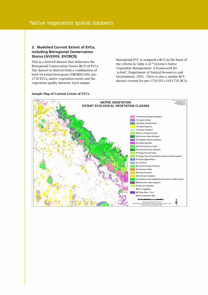
3. Modelled Current Extent of EVCs, including Bioregional Conservation Status (NV2005_EVCBCS) This is a derived dataset that delineates the Bioregional Conservation Status (BCS) of EVCs. The dataset is derived from a combination of both Victorian bioregions (VBIOREG100), pre-1750 EVCs, native vegetation extent and the vegetation quality datasets. Each unique
bioregional EVC is assigned a BCS on the basis of the criteria in Table 4 of “Victoria’s Native Vegetation Management: A Framework for Action”, Department of Natural Resources and Environment, 2002. There is also a similar BCS dataset created for pre-1750 EVCs (NV1750_BCS).
Sample Map of Current Extent of EVCs

Native vegetation spatial datasets
4. Modelled Native Vegetation Quality – [Habitat Hectare] (NV2005_QUAL) dataset A new model of vegetation condition across Victoria has been created which will assist land management agencies to identify priority areas for investment, restoration and conservation activities. This modelled Native Vegetation Quality dataset (see Native Vegetation Information Sheet 4 – Native vegetation quality dataset) is based on the Habitat Hectares approach.
It comprises the combination of data from a site condition model (75% of the Habitat score) which spatially predicts the condition of native vegetation across the landscape from site-based assessments plus the Patch-based Landscape Context assessment (the remaining 25% of the overall Habitat score). These two datasets are described in more detail below.
Sample map of native vegetation quality

Native vegetation spatial datasets
4a. Site Condition model The site condition model is based on statistical relationships (established using a neural network modelling process) between many sample sites with known vegetation condition and a suite of mapped biophysical data such as soil type, tree
density, satellite imagery and climatic and topographical variables. These relationships are then applied to the interplay of these same mapped biophysical data to predict the condition of native vegetation.
Sample map of site condition

Native vegetation spatial datasets
4b. Patch-based Landscape Context Model This dataset looks at the size and shape of a patch of remnant native vegetation and its connectivity and proximity to adjacent patches of remnant native vegetation. It is intended that this automated process will replace the need to manually calculate the landscape context
component of site-based Habitat Hectare assessments.
Existing native vegetation is assigned a rating of 0 – 25 based on measures of patch size, patch shape, landscape connectivity and proximity.
Sample map of Patch-based Landscape Context

Native vegetation spatial datasets
Published by the Victorian Government Department of Sustainability and Environment Melbourne, December 2007© The State of Victoria Department of Sustainability and Environment 2007 This publication is copyright. No part may be reproduced by any process except in accordance with the provisions of the Copyright Act 1968. Authorised by the Victorian Government, 8 Nicholson Street, East Melbourne. ISBN 978-1-74208-225-7 For more information contact the DSE Customer Service Centre 136 186 This publication may be of assistance to you but the State of Victoria and its employees do not guarantee that the publication is without flaw of any kind or is wholly appropriate for your particular purposes and therefore disclaims all liability for any error, loss or other consequence which may arise from you relying on any information in this publication.
www.dse.vic.gov.au
Glossary of terms
A glossary of some of the terms used in this
Information Sheet can be found on the Native
Vegetation Information for Victoria web page.
Viewing spatial vegetation datasets:
Web Mapping Tools
1. Biodiversity Interactive Map
Biodiversity and Ecosystem Services (BES) has developed the Biodiversity Interactive Map (powered by MapShare) which is available on DSE’s external website at www.dse.vic.gov.au > Online services - Interactive maps > Biodiversity Interactive Map.
This web mapping tool provides a number of different views of native vegetation:–
• native vegetation extent (NV2005_EXTENT)
• native vegetation quality (NV2005_QUAL)
• estimated pre-European extent of EVCs (NV1750_EVC)
• current extent of EVCs (NV2005_EXTENT)
• Bioregional Conservation Status of EVCs (NV2005_EVCBCS) and
• groupings of similar EVCs.
2. Image Web Server
This data will also be available as TIF files for ArcView, ArcGIS and MapInfo users on DSE’s Image Web Server. (The Image Web Server is a central store for Victorian Government aerial photography, satellite imagery and digital maps.) The Image Web Server can be accessed via the following link: www.land.vic.gov.au/iwsinfo.
Accessing spatial layers in the CSDL All DSE staff are able to access spatial data layers held in the DSE Corporate Spatial Data Library (CSDL). Associated metadata for DSE staff can be accessed via the following links:
Modelled 1750 Ecological Vegetation Classes (with Bioregional Conservation Status)
Modelled 1750 Ecological Vegetation Classes
Modelled 2005 Ecological Vegetation Classes (with Bioregional Conservation Status)
Modelled Extent 2005 (25 metre raster)
Modelled Quality 2005 (Site condition and landscape context)
Access for external organisations
1. The data can be viewed on the Biodiversity Interactive Map which is available on DSE’s external website at www.dse.vic.gov.au > Online services - Interactive maps > Biodiversity Interactive Map.
2. To access the data directly, a data licensing agreement with DSE is required. This can be obtained by emailing the Data Distribution Manager: [email protected]. Associated metadata can be accessed via the following links:
Modelled 1750 Ecological Vegetation Classes (with Bioregional Conservation Status)
Modelled 1750 Ecological Vegetation Classes
Modelled 2005 Ecological Vegetation Classes (with Bioregional Conservation Status)
Modelled Extent 2005 (25 metre raster)
Modelled Quality 2005 (Site condition and landscape context)
Contact Any queries regarding spatial datasets or EVC mapping can be directed by email to: [email protected]