NATIONAL REPORT OF SWEDEN Executive summary 1 ... · NATIONAL REPORT OF SWEDEN Executive summary...
12
17 th BSHC Meeting National Report 18-20 September 2012, Helsinki Sweden NATIONAL REPORT OF SWEDEN Executive summary This report gives a summary of the main activities within the Swedish Hydrographic Office since the last report given at the 16 th BSHC meeting in Norrköping September 2011. 1. Hydrographic Office At the time of compiling this report 117 persons (106 by the last BSHC meeting) are employed by the Hydrographic Office. The increase of personal is due to the fact that several external assignments have been tasked to the Hydrographic Office. These are further described under chapter 9 – Other Activities. The operations are certified by Lloyd´s register quality assurance in accordance with ISO 9001:2008. Yearly quality audits are conducted by Lloyds and internal auditors. The Hydrographic Office organisational structure is described below. 2. Surveys Most Swedish waters are surveyed to some degree over the years and most of the fairway areas to a high standard. The long term objective is that all Swedish waters should be surveyed in accordance with the international standard S-44. Surveys and re-surveys now and in the coming years are focused to fairway areas in the SMA Safe Seaways concept (Säkra sjövägar), which is a part of the HELCOM Hydrographic re-Survey plan for the Baltic Sea. This concept encompasses over 80 000 km² out of totally 165 000 km² within the Swedish EEZ. During 2011 a total amount of
Transcript of NATIONAL REPORT OF SWEDEN Executive summary 1 ... · NATIONAL REPORT OF SWEDEN Executive summary...

17th
BSHC Meeting National Report
18-20 September 2012, Helsinki Sweden
NATIONAL REPORT OF SWEDEN
Executive summary This report gives a summary of the main activities within the Swedish Hydrographic
Office since the last report given at the 16th BSHC meeting in Norrköping September 2011.
1. Hydrographic Office
At the time of compiling this report 117 persons (106 by the last BSHC meeting) are
employed by the Hydrographic Office. The increase of personal is due to the fact that
several external assignments have been tasked to the Hydrographic Office. These are
further described under chapter 9 – Other Activities.
The operations are certified by Lloyd´s register quality assurance in accordance with ISO
9001:2008. Yearly quality audits are conducted by Lloyds and internal auditors.
The Hydrographic Office organisational structure is described below.
2. Surveys
Most Swedish waters are surveyed to some degree over the years and most of the fairway
areas to a high standard. The long term objective is that all Swedish waters should be
surveyed in accordance with the international standard S-44.
Surveys and re-surveys now and in the coming years are focused to fairway areas in the
SMA Safe Seaways concept (Säkra sjövägar), which is a part of the HELCOM
Hydrographic re-Survey plan for the Baltic Sea. This concept encompasses over 80 000
km² out of totally 165 000 km² within the Swedish EEZ. During 2011 a total amount of
BSHC17 National report of Sweden Page 2 (12)
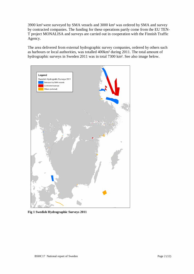
3900 km² were surveyed by SMA vessels and 3000 km² was ordered by SMA and survey
by contracted companies. The funding for these operations partly come from the EU TEN-
T project MONALISA and surveys are carried out in cooperation with the Finnish Traffic
Agency.
The area delivered from external hydrographic survey companies, ordered by others such
as harbours or local authorities, was totalled 400km² during 2011. The total amount of
hydrographic surveys in Sweden 2011 was in total 7300 km². See also image below.
Fig 1 Swedish Hydrographic Surveys 2011
BSHC17 National report of Sweden Page 3 (12)
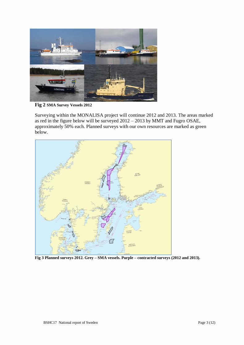
Fig 2 SMA Survey Vessels 2012
Surveying within the MONALISA project will continue 2012 and 2013. The areas marked
as red in the figure below will be surveyed 2012 – 2013 by MMT and Fugro OSAE,
approximately 50% each. Planned surveys with our own resources are marked as green
below.
Fig 3 Planned surveys 2012. Grey – SMA vessels. Purple – contracted surveys (2012 and 2013).

BSHC17 National report of Sweden Page 4 (12)
Depth Database
Fig 4 All data in the soundings database DIS, including
digitized older fair sheets. Status in July 2012.
Fig 5 Data that fulfils IHO S-44. Status in July 2012.
3. New charts and updates
Paper Charts
The Swedish paper chart portfolio consists of approximately 120 charts and 14 series of
charts for small craft. Special charts, tailored to the customer, such as “print on demand”
charts are also available as well as a service to provide chart images to mobile phones and
PDA’s.
During the period the following new charts were issued:
Chart Scale INT Name
SE 10 1:250 000 INT 1770 Mälaren – Hjälmaren
SE 742 1:50 000 INT 1326 Åhus – Karlshamn
SE 743 1:50 000 INT 1325 Simrishamn – Åhus
SE 7411 1:25 000 INT 1329 Utlängan – Karlskrona
BSHC17 National report of Sweden Page 5 (12)
Fig 6 New Charts produced since last BSHC meeting.
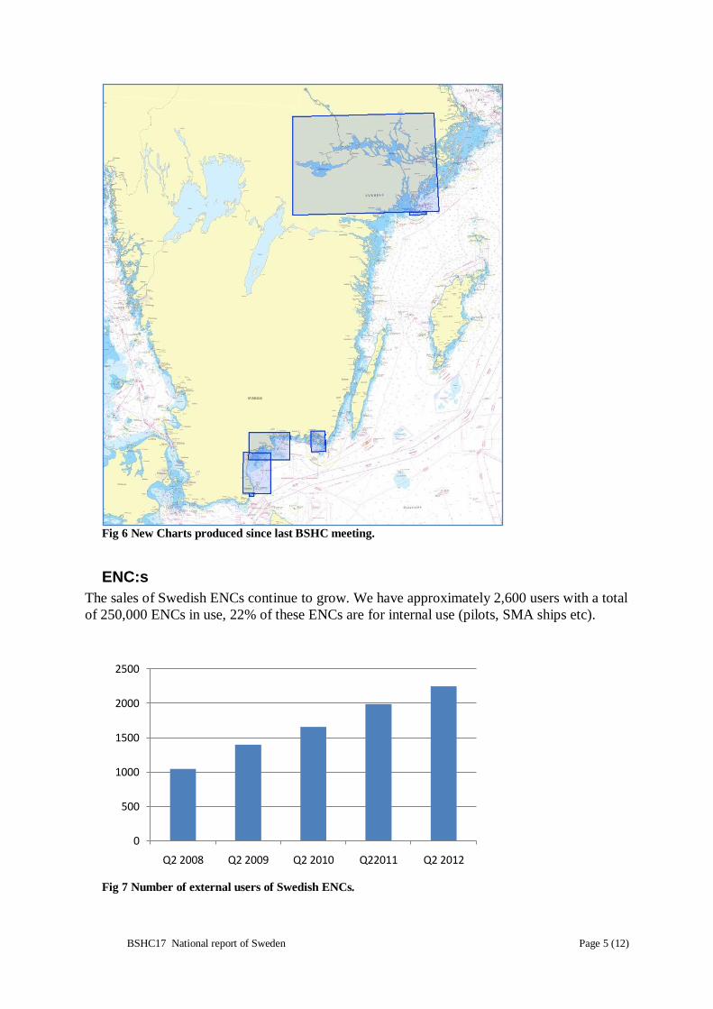
ENC:s
The sales of Swedish ENCs continue to grow. We have approximately 2,600 users with a total
of 250,000 ENCs in use, 22% of these ENCs are for internal use (pilots, SMA ships etc).
Fig 7 Number of external users of Swedish ENCs.
0
500
1000
1500
2000
2500
Q2 2008 Q2 2009 Q2 2010 Q22011 Q2 2012

BSHC17 National report of Sweden Page 6 (12)
Fig 8 Number of Swedish ENCs for external use.
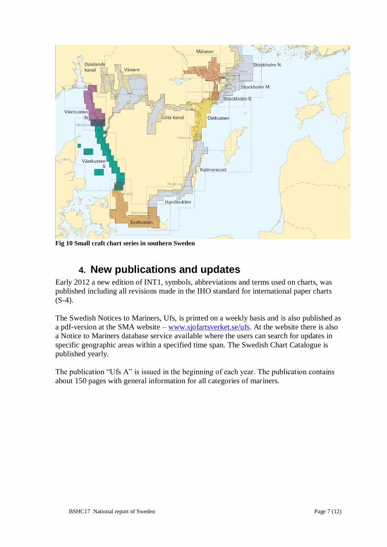
Small Craft Charts
The sales of Swedish small craft charts are very
important for our net result. For the 2012 season we
have produced the following booklets in New
Editions: Mälaren, Sydkusten, Västkusten N,
Västkusten S and Ostkusten. In Sydkusten and
Västkusten S we have included some Danish charts
to make the product more complete for the end user.
The design of the cover has been revised to comply
with the new SMA profile programme.
0
50000
100000
150000
200000
250000
Q2 2008 Q2 2009 Q2 2010 Q22011 Q2 2012
Fig 9 A totally new produced small craft chart covering
the coast of Skåne and also contains some Danish charts.
BSHC17 National report of Sweden Page 7 (12)
Fig 10 Small craft chart series in southern Sweden
4. New publications and updates
Early 2012 a new edition of INT1, symbols, abbreviations and terms used on charts, was
published including all revisions made in the IHO standard for international paper charts
(S-4).
The Swedish Notices to Mariners, Ufs, is printed on a weekly basis and is also published as
a pdf-version at the SMA website – www.sjofartsverket.se/ufs. At the website there is also
a Notice to Mariners database service available where the users can search for updates in
specific geographic areas within a specified time span. The Swedish Chart Catalogue is
published yearly.
The publication “Ufs A” is issued in the beginning of each year. The publication contains
about 150 pages with general information for all categories of mariners.

BSHC17 National report of Sweden Page 8 (12)
Fig 12 Ufs A. General information for
all categories of mariners
5. MSI Ships reports and field strength measurements have
indicated that the NAVTEX transmitter in Grimeton
has not been covering the Swedish part of Skagerrak
sufficiently.
Discussions with Telenor Maritime Radio in
Norway and the IMO Navtex co-ordinating panel
took place in 2011 and resulted in changes to the
NAVTEX pattern in the affected area. In the
beginning of 2012 SMA and Telenor signed a
financial agreement and consequently the NAVTEX
map has the shown appearance since 2 April 2012.
The table below shows the number of Navigational
Warnings that have been transmitted on Navtex over
the latest five years. The increased number of
Finnish, Swedish and Danish warnings in the last
years is a result of the laying of the Nord Stream gas
pipeline.
Fig 11 New Swedish Edition of
INT1
Fig 13 NAVTEX in the Baltic Sea area
BSHC17 National report of Sweden Page 9 (12)
Nation 2007 2008 2009 2010 2011
Denmark 123 105 98 87 117
Estonia 6 5 3 7 5
Finland 29 13 28 91 53
Germany 127 71 73 99 92
Latvia 17 22 24 20 27
Lithuania 32 34 27 34 31
Poland 86 72 70 74 78
Russia, Kaliningr. 151 32 49 66 68
Russia, Petersb. 5 16 29 33 32
Sweden 66 97 97 117 156
TOTAL 642 467 498 665 697
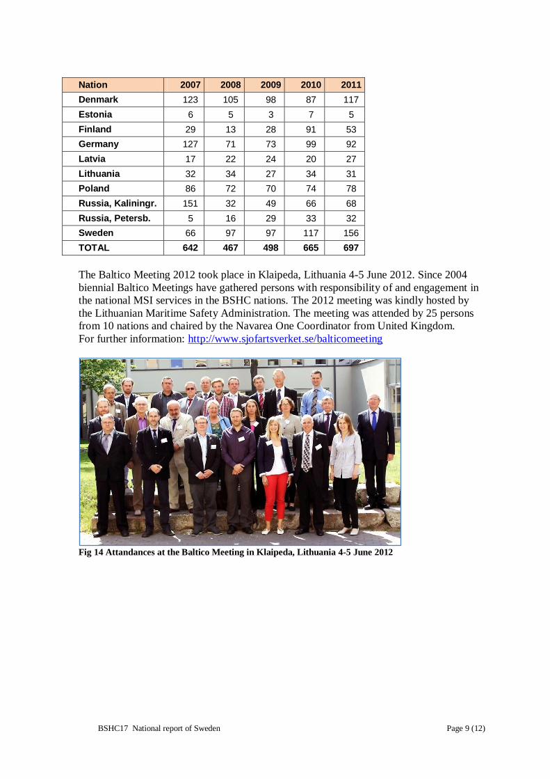
The Baltico Meeting 2012 took place in Klaipeda, Lithuania 4-5 June 2012. Since 2004
biennial Baltico Meetings have gathered persons with responsibility of and engagement in
the national MSI services in the BSHC nations. The 2012 meeting was kindly hosted by
the Lithuanian Maritime Safety Administration. The meeting was attended by 25 persons
from 10 nations and chaired by the Navarea One Coordinator from United Kingdom.
For further information: http://www.sjofartsverket.se/balticomeeting
Fig 14 Attandances at the Baltico Meeting in Klaipeda, Lithuania 4-5 June 2012

BSHC17 National report of Sweden Page 10 (12)
6. C-55
The latest update regarding Sweden in the C-55 database was delivered in March 2011.
7. Capacity building
Sweden has not been active in the area of capacity building during the period.
8. Oceanographic activities
The Swedish Maritime Administration (SMA) is responsible for a number of water level
stations but it is the Swedish Meteorological and Hydrological Institute (SMHI) that has
the main responsibility for the Swedish oceanographic activities. Other actors are the
Swedish Geological Survey and universities and research institutes.
In conjunction with the MONALISA project a working relationship with Stockholm
University department of Geological Sciences has been established. Especially worth
mentioning here is the cooperation with Professor Dr. Martin Jakobsson who is professor
of Marine Geology and Geophysics and also active in the GEBCO work.
9. Other activities
National Geodata Portal and Inspire
The Swedish HO continues to take part in the national activities to implement the Inspire
directive of the EU and the establishment of the national SDI (Spatial Data Infrastructure)
and a geodata portal. A national geodata portal is established and Swedish HO contributes
with metadata according to the Inspire directive and some basic datasets. See also
http://www.geodata.se/en/.

BSHC17 National report of Sweden Page 11 (12)
National Shore Line Data Quality Improvement
For a number of years the HO is involved in a joint project with the National Land Survey
to manage and improve a national shore line data theme together. One fundamental aim
apart from a need to improve quality is to facilitate products that are cross-shore-line for
coastal zone management and other applications. For new and totally revised charts this
data has been used for some years now. In 2010 we also started to do thematic updates in
the chart database of the shore line based on this high quality data and this has also
continued during 2011 and 2012. This is a major improvement for use together with
absolute GPS navigation.
Fig 15 Areas where National Shore Line data have been implemented in Swedish ENC:s and paper
charts. Blue – Berthing, Green – Harbour and Purple – Approach.
Converting fair sheet archive (ScanDIS)
The digitizing of soundings from fair sheets and similar maps in our archive continues with
the overall aim to create national coverage in the soundings database (DIS). For the
Hydrographic Office in particular, this will enable new and more efficient production of
chart information.
This operation is since 2007 permanent in our organization and will continue at least until
2013. The Swedish government supports us financially as a part of a special Baltic Sea
programme. We co-operate with the new established agency Swedish Agency for Marine
and Water Management (Havs- och Vattenmyndigheten) in planning and prioritizing this
work. So far we have processed approximately 5200 of an estimated 8 000 sheets and maps
in the archive.

BSHC17 National report of Sweden Page 12 (12)
A new national commission for revision of maritime boundaries
As announced at BSHC16 a maritime boundaries commission was started 2011. The task is
to revise baselines and associated features and subsequently establish the territorial limits
in an up to date fashion. The last revision of maritime boundaries was in the early 1960’s
and there has been considerable land uplift to consider, erosion and also changes in
legislation since then. The Swedish HO are currently working with identification and
surveying of objects which will define the revised baseline.
Fig 16 Surveying a rock awash at the Swedish west coast May 2012.
A bathymetry database concept for the Baltic Sea
The Swedish government has tasked the HO to develop a proposal for availability and
distribution of bathymetry data for the Baltic Sea and to use the IHO regional network to
achieve the result. The Baltic Sea Bathymetry Database Working Group (BSBDWG) has
been formed to work on this. There is good funding for the activity as it is also included in
the ongoing MONALISA project. Work will continue until the end of 2013 and all corner
stones of a possible Baltic Sea Bathymetry SDI, governance, content and technology will
be studied. The EU INSPIRE directive provides important requirements to include in the
study.