National Register of Historic Places Registration Form Historic District...United States Department...
66
NPS Form 10-900 OMB No. 1024-0018 1 United States Department of the Interior National Park Service National Register of Historic Places Registration Form This form is for use in nominating or requesting determinations for individual properties and districts. See instructions in National Register Bulletin, How to Complete the National Register of Historic Places Registration Form. If any item does not apply to the property being documented, enter "N/A" for "not applicable." For functions, architectural classification, materials, and areas of significance, enter only categories and subcategories from the instructions. Place additional certification comments, entries, and narrative items on continuation sheets if needed (NPS Form 10-900a). 1. Name of Property historic name Montlake Historic District other names/site number 2. Location street & number Approximately 50 blocks bounded by the Lake Washington Ship Canal, Interlaken Park, 15 th Ave. E., and the Washington Park Arboretum. not for publication city or town Seattle vicinity state Washington code WA county King code 033 zip code 98112 3. State/Federal Agency Certification As the designated authority under the National Historic Preservation Act, as amended, I hereby certify that this nomination request for determination of eligibility meets the documentation standards for registering properties in the National Register of Historic Places and meets the procedural and professional requirements set forth in 36 CFR Part 60. In my opinion, the property _ meets _ does not meet the National Register Criteria. I recommend that this property be considered significant at the following level(s) of significance: national statewide local Applicable National Register Criteria A B C D Signature of certifying official/Title Date WASHINGTON SHPO State or Federal agency/bureau or Tribal Government In my opinion, the property meets does not meet the National Register criteria. Signature of commenting official Date Title State or Federal agency/bureau or Tribal Government 4. National Park Service Certification I hereby certify that this property is: entered in the National Register determined eligible for the National Register determined not eligible for the National Register removed from the National Register other (explain:) _________________ Signature of the Keeper Date of Action
Transcript of National Register of Historic Places Registration Form Historic District...United States Department...

NPS Form 10-900 OMB No. 1024-0018
1
United States Department of the Interior National Park Service
National Register of Historic Places Registration Form This form is for use in nominating or requesting determinations for individual properties and districts. See instructions in National Register Bulletin, How to Complete the National Register of Historic Places Registration Form. If any item does not apply to the property being documented, enter "N/A" for "not applicable." For functions, architectural classification, materials, and areas of significance, enter only categories and subcategories from the instructions. Place additional certification comments, entries, and narrative items on continuation sheets if needed (NPS Form 10-900a).
1. Name of Property
historic name Montlake Historic District
other names/site number
2. Location
street & number Approximately 50 blocks bounded by the Lake Washington Ship Canal, Interlaken Park, 15th Ave. E., and the Washington Park Arboretum. not for publication
city or town Seattle vicinity
state Washington code WA county King code 033 zip code 98112
3. State/Federal Agency Certification
As the designated authority under the National Historic Preservation Act, as amended, I hereby certify that this nomination request for determination of eligibility meets the documentation standards for registering properties in the National Register of Historic Places and meets the procedural and professional requirements set forth in 36 CFR Part 60. In my opinion, the property _ meets _ does not meet the National Register Criteria. I recommend that this property be considered significant at the following level(s) of significance: national statewide local Applicable National Register Criteria A B C D
Signature of certifying official/Title Date
WASHINGTON SHPO State or Federal agency/bureau or Tribal Government
In my opinion, the property meets does not meet the National Register criteria.
Signature of commenting official Date
Title State or Federal agency/bureau or Tribal Government 4. National Park Service Certification
I hereby certify that this property is: entered in the National Register determined eligible for the National Register determined not eligible for the National Register removed from the National Register other (explain:) _________________
Signature of the Keeper Date of Action

United States Department of the Interior National Park Service / National Register of Historic Places Registration Form NPS Form 10-900 OMB No. 1024-0018
Montlake Historic District King County, WA Name of Property County and State
2
5. Classification
Ownership of Property (Check as many boxes as apply.)
Category of Property (Check only one box.)
Number of Resources within Property (Do not include previously listed resources in the count.)
Contributing Noncontributing
x private building(s) 872 261 buildings x public - Local x district district x public - State site 5 1 site x public - Federal structure 366 114 structure object object 1243 376 Total
Name of related multiple property listing (Enter "N/A" if property is not part of a multiple property listing)
Number of contributing resources previously listed in the National Register
N/A 1
6. Function or Use
Historic Functions Current Functions
DOMESTIC/Single Dwelling DOMESTIC/Single Dwelling
COMMERCE/TRADE COMMERCE/TRADE
SOCIAL/Clubhouse SOCIAL/Clubhouse
SOCIAL/Meeting Hall SOCIAL/Meeting Hall
GOVERNMENT/Government Office GOVERNMENT/Government Office
EDUCATION/School EDUCATION/School
RECREATION AND CULTURE/Sports Facility RECREATION AND CULTURE/Sports Facility
LANDSCAPE/Park LANDSCAPE/Park
TRANSPORTATION/Road Related TRANSPORTATION/Road Related

United States Department of the Interior National Park Service / National Register of Historic Places Registration Form NPS Form 10-900 OMB No. 1024-0018
Montlake Historic District King County, WA Name of Property County and State
3
7. Description
Architectural Classification Materials
LATE 19TH & 20TH CENTURY REVIVAL: Colonial foundation: Concrete, wood
Revival, Tudor Revival, Georgian Revival walls: Wood, brick, stucco, asphalt, glass, metal,
Spanish Colonial Revival, Garrison Revival Concrete
LATE 19TH & EARLY 20TH CENTURY
AMERICAN MOVEMENTS: Craftsman roof: Wood, asphalt
MODERN MOVEMENT: Ranch, Minimal other:
Traditional
Narrative Description Summary Paragraph The Montlake neighborhood of Seattle is a residential area built primarily before World War II. During its most intense growth period (the 1920s), it developed along a streetcar line, gaining a small commercial district typical of the early streetcar suburbs that surrounded downtown Seattle. It was also influenced by its proximity to the University of Washington campus. During this era, the student population at the university increased by 54 percent accommodated by construction both on campus and in nearby commercial and residential areas, including Montlake. The neighborhood is particularly known for its unique location surrounded by water and parks. Montlake exhibits the full range of residential architectural styles typical of pre-World War II Seattle neighborhoods, with an especially strong representation of Tudor Revival houses. Most of its residences are relatively modest structures, with some examples of high-style architect-designed buildings. The district also includes community amenities such as a school, a library, a community center and a playfield. The period of significance for the Montlake Historic District begins in 1904 – the construction date of the first contributing building – and ends in 1959, at the tail end of active build-out of the area and prior to construction of State Route 520. The district retains a strong level of integrity of location, setting, design, materials, workmanship, feeling, and association; 76 percent of resources contribute to the historic district. Many individual buildings within the district demonstrate a high level of integrity. The district boundaries are discontiguous, excluding the State Route 520 corridor, completed in 1963. Two blocks (the Montlake Park plat) are north of the corridor, and the remaining 48 blocks are south of it. The numbers of contributing and non-contributing resources are as follows: Buildings and Sites Historic Contributing: 877 Historic Non-Contributing: 210 Non-Historic Non-Contributing: 52 Vacant: 7 TOTAL: 1146 Accessory Structures/Garages Historic Contributing: 366 Historic Non-Contributing: 22 Non-Historic Non-Contributing: 88 TOTAL: 480

United States Department of the Interior National Park Service / National Register of Historic Places Registration Form NPS Form 10-900 OMB No. 1024-0018
Montlake Historic District King County, WA Name of Property County and State
2
_______________________________________________________________________________________________________________________ Narrative Description Setting Seattle's Montlake neighborhood is located northeast of downtown Seattle, between the University of Washington campus to the north and the Capitol Hill neighborhood to the south. It is generally described as extending from the Washington Park Arboretum west to Portage Bay/15th Avenue E., and from the Montlake Cut on the north to Interlaken Park at the south end. In the early 1960s, construction of SR 520 cut through Montlake, but the neighborhood retains many aspects of integrity, as well as its overall character as a pre-World War II Seattle neighborhood. The topography is generally flat in much of the northern section, but it has hilly sections toward the south, where a steep slope ascends to Interlaken Boulevard. Water vistas are important contributors to the neighborhood character. On the north is Montlake cut, which connects lakes Washington and Union, part of the NRHP-listed Lake Washington Ship Canal. Montlake is also surrounded by parks and boulevards. On the eastern edge is Lake Washington Boulevard and the Washington Park Arboretum. The south edge of the neighborhood is defined primarily by Interlaken Boulevard and Interlaken Park, which is part of a very steep slope at the northern edge of the Capitol Hill neighborhood. There are additional smaller parks, including East Montlake Park, West Montlake Park and Boyer Pocket Park. The Montlake Playfield is a large open space and recreational area facing onto Portage Bay. Montlake's street pattern is complex. The major north-south arterial, 24th Avenue E. (which becomes Montlake Boulevard Northeast) is a major access point for the SR 520 freeway. Boyer Avenue E., the primary east-west arterial, winds along the southern boundary. The area north of SR 520 (the Montlake Park plat) and the area north of E. Lynn Street have a predominant grid pattern. However, the northeast section has a complex system of alleys, and the northwest section near the Montlake Playfield has hilly topography and dead-end streets. Streets typically have sidewalks on both sides and many, but not all, blocks have alleys that accommodate garages. In blocks without alleys, garages are located either behind the house, accessed by a driveway, or, on sloping lots, dug into the front of the lot at the sidewalk. Residential landscaping varies considerably. The typical street has front yards traditionally landscaped with lawn, planting beds, shrubs and small trees. Some houses have large trees in either the front or rear yards. An increasing number of home owners have removed lawns and landscaped the entire front yard with groundcovers, shrubs and other plantings. In some blocks, houses sit above the street with rockeries or retaining walls. While some houses have tall fences in front, these are relatively unusual; rear fences are more common. Most blocks have street trees, although there is little uniformity because they have been planted over time by individual homeowners. In some blocks they vary considerably in location, size and species, while other blocks are lined with a single species. Flowering cherries and plums are particularly popular. Contributing and Non-Contributing Resources As noted earlier, contributing resources to the historic district constitute a substantial percentage of the total buildings. A relatively small number of buildings have alterations significant enough for them to be considered non-contributing resources to the district. The most common such alterations are large, visible additions or notable changes to the front porch or entry. The presence of newer window sash or cladding was not necessarily considered significant if the overall character of the building remained. However, the commercial buildings have significantly altered storefronts or massing; only one is a contributing resource. Four of the institutional buildings are contributing resources, as are the parks that are within the boundaries of the district. The district has 1,243 historic contributing buildings, primarily residences. Construction dates were derived from the King County Assessor’s records. The vast majority (over 85 percent) were built prior to 1940, with about seven percent of all resources built during or shortly after World War II. Only about six percent of buildings within the district were constructed after the period of significance (1959). Residential Architectural Styles and Periods Although the earliest historic contributing house in the district dates to 1904, construction occurred primarily between 1910 and 1940, therefore the most common residential architectural styles seen in Montlake are typical of those found in other older Seattle neighborhoods: Craftsman, Tudor Revival, and Colonial Revival. Other styles/types (including American/Workingman’s Foursquare, Prairie, Spanish Revival, French Eclectic and French Norman) are also found but are relatively unusual. Styles from the post-World War II period, found in smaller numbers, include Minimal Traditional, Ranch and Modern/Contemporary. Below is a general description of predominant building styles, as well as their general distribution within the district. Residential architectural styles are generally well distributed throughout the district, and

United States Department of the Interior National Park Service / National Register of Historic Places Registration Form NPS Form 10-900 OMB No. 1024-0018
Montlake Historic District King County, WA Name of Property County and State
3
correlate directly with the construction dates of individual buildings. However, there are some notable exceptions, where building styles are clustered in certain areas within the district.
Arts & Crafts – Craftsman (1900-1930) The Craftsman style is one of the most represented styles in the Montlake Historic District, and comprises approximately 25 percent of the district buildings. This style was influenced by the English Arts and Crafts movement, Asian architecture, and manual arts, was immensely popular in the United States in the early 20th century. Typical houses (many of which are bungalows) feature wood cladding (shingles or lapped bevel siding), low-pitched gabled roofs, decorative beams or braces under gables, exposed wood rafters, and overhanging eaves. Dormers are typically gabled or shed, houses often have exterior stone or brick chimneys and partial or full-façade front porches, with a roof supported by square columns (McAlester 2013:568-578). Although Craftsman-style houses are evident throughout the district, there are two areas where the majority of these houses are clustered. On the east end of the district, on 19th and 20th Avenues between Calhoun and McGraw Streets, over 65 percent of the houses are in the Craftsman style; most are bungalows with designs probably derived from pattern books and constructed between 1919 and 1924. The houses vary, but they typically feature traditional Craftsman characteristics such as shallow-pitched gabled roofs with overhanging eaves and knee brackets; prominent front porches with sturdy piers (often of brick) or tripartite windows with divided lights. An interesting example, at 1904 E. McGraw Street, features Japanese-inspired carved brackets and flared bargeboards. Another strong concentration of Craftsman-style houses is in the southeast section of the district, between E. Lynn and E. Boyer Streets and 24th Avenue E. and the Arboretum. In the southeast end of the district, in the area bordered by E. Newton St., 24th Ave. E., Boyer Ave. E., and the Arboretum, almost half of the buildings are Craftsman style, probably derived from pattern books. In this section of the district, Craftsman style houses are more widely distributed over time, with the earliest (1719 26th Avenue E.) built in 1909 and the latest (1958 25th Avenue E.) built in 1926. These dates span what is largely considered to be the duration of the Craftsman period, 1905-1930 (McAlester: 567). The Prairie style is an American architectural style that developed at the same time that the Craftsman style became popular. It is much less common in Seattle, and there is only one example in Montlake, at 2021 E. Lynn Street (1912). American Foursquare (1895-1920) Although American Foursquare houses are very common in nearby Capitol Hill, there are only twelve examples in the Montlake Historic District, distributed randomly through the district. This housing type is generally square, but occasionally rectangular, in plan, and is two-and-a-half stories, usually with a hipped roof with deep overhangs. Cladding is typically wood, and many examples have full or partial-width porches, hipped-roof bay windows at 2nd floor corners, and large central dormers (Schweitzer and Davis 1990: 161-68). Styles of American Foursquare dwellings range from Craftsman and Colonial to Prairie and Spanish Colonial. Representative examples in the Montlake Historic District include 2137 E. Hamlin Street (1925), 2143 E. Shelby Street (1923), 2208 E. McGraw Street (1909), and 2221 E. Newton Street (1919). Colonial - Colonial Revival (1900-1940) Approximately 17 percent of houses in the Montlake Historic district are in the Colonial Revival or Colonial Bungalow style. They are widely distributed throughout the district in no discernible pattern. The Colonial Revival style is generally considered the most popular architectural style in the United States, reflecting the influence of early English and Dutch residences (McAlester 2013:409-432). These houses are typically two stories (with the exception of the bungalow, described below) with gabled or hipped roofs and are rectangular or square in plan. The facade is symmetrical with a centered entrance, typically flanked by pairs of double-hung sashes (often multi-paned). The entry has a portico or an entry vestibule rather than a porch, with Colonial detailing and millwork such as pilasters, columns, fanlights or sidelights. In Seattle, wood clapboard cladding is most typical. Representative examples of Colonial Revival houses in the Montlake Historic District include 2004 E Lynn St (1913), 1633 E Calhoun St (1940), and 2127 Boyer Avenue E (1925). The Colonial Bungalow is a smaller subtype of this style, with only one or one-and-a-half stories, but with a symmetrical facade and Colonial detailing. These are well represented in Montlake compared to the rest of the city. Two examples are 2032 23rd Avenue E (1922), 1927 E. Calhoun Street (1922), 2224 E. Calhoun Street (1925), and 2403 25th Avenue E. (1923).

United States Department of the Interior National Park Service / National Register of Historic Places Registration Form NPS Form 10-900 OMB No. 1024-0018
Montlake Historic District King County, WA Name of Property County and State
4
Colonial - Dutch Colonial Revival (1910-1940) The Dutch Colonial is a subtype of the Colonial Revival style, with similar facades, entries, multi-paned window sash and detailing, but are distinguished by a gambrel roof. Fewer than five percent of houses within the Montlake Historic District are in the Dutch Colonial style, and they are widely distributed throughout the district in no discernible pattern. Dutch Colonial-style houses are typically one one-half stories, with the gambrel containing almost a full second story of space. The roofs are often steeply pitched. Early examples (c. 1915) often feature a front-gambrel roof, while later examples in the 1920s and 1930s have side gambrels with long shed dormers (McAlester 2013:424). Some representative examples of this style include 2026 E. Calhoun Street (1927), 2133 E. Hamlin Street (1919), 2000 26th Avenue E. (1922), and 1853 E. Hamlin Street (1919). Colonial - Georgian Revival (1900-1930) Fewer than ten houses in the Montlake Historic District were built in the Georgian Revival style. This style was influenced by the New England Georgian Colonial, and is generally rectangular in plan, two stories, clad in masonry or brick veneer, and have a hipped or gabled roof. Most have a central entrance, usually with columns, and windows are typically multi-paned double hung wood sash (McAlester 2013: 412-14, Schweitzer and Davis 1990:154). Representative examples of this type in Montlake include 2159 E. Shelby St. (1915) and 1931 Boyer Ave. E (1936). Colonial - Garrison Revival (1930-75) A small number of houses (fewer than 10) within the district are in the Garrison Revival style, a late interpretation of the Colonial Revival style, all of which were built in the 1940s and are just south of the Montlake playfield. This style is characterized by a symmetrical entry and fenestration and an overhanging second story (McAlester 2013:426). Representative examples in the Montlake Historic District include 1601 E. Calhoun Street (1940), 2156 Boyer Avenue E (1948), and 2142 Boyer Avenue E (1947).
Tudor Revival (1910-1940) Approximately 27 percent of houses within the Montlake Historic District are in the Tudor Revival style, making this the most typical style in the district. There are many varied examples within the district, the majority of which were constructed in the late 1920s and early 1930s. Tudor Revival-style houses are generally clad in brick, although stucco and wood cladding is also evident. Brickwork can be patterned or clinkered, and stonework is often evident in trim, chimneys, and quoins. Many houses have decorative half-timbering detail, arched doorways, and large exterior chimneys, often stepped in and with patterned brick and stonework and multiple shafts. Windows are typically tall and narrow, often presented in bands, and have multi-pane glazing, occasionally diamond-shaped. Windows can be casement, double-hung, oriel, and semi-hexagonal one- and two-story bays. Roofs are steeply pitched and often side-gabled, and the front façade is typically dominated by a front-facing gable. Many gables are clipped. Stylistic variations of the Tudor Revival include Elizabethan, and Cottage style (McAlester 2013: 450-66). Montlake has two Tudor Revival model homes, built to promote home construction and the use of specific materials. The 1926 Model Brick Home (2600 E. Montlake Place East) was sponsored by the Northwest Brick and Tile Association to demonstrate the desirability, durability, low maintenance, and affordability of a brick home. It was designed by William J. Bain and built by Barnum-Lemcke, developers of the Glenwilde Addition, and Daniel & Anderson, contractors. Its construction was heavily publicized and more than 5,000 people visited the first weekend after completion. The house is faced with decorative brick and features numerous leaded glass windows and a steep gabled roof clad with flat fired clay tiles (The Seattle Daily Times, April 28, 1926: 19). "The Home Beautiful" (1897 E. Shelby Street) was built as a promotion for the use of western red cedar as a building material by the Red Cedar Lumber Manufacturers Association. The Elizabethan Tudor house was designed by architect Samuel Anderson. It features wood clapboard cladding, a wood shingle roof with decorative verge boards, and stuccoed half-timbering in the gable ends. It is among the most detailed houses in the Montlake Historic District, with an ornate entry with a metal awning and a Tudor-arched door, quatrefoils, cartouches and numerous leaded windows including a three-sided hanging bay and lancet windows, some with colored glass (The Seattle Daily Times, September 9, 1926: 23). Although the Tudor Revival style is well represented and widely distributed throughout the district, there are some concentrations that were built as groups. The largest of these is a group of 27 brick homes between Boyer Avenue and 18th Avenue E., and E. McGraw and E. Lynn Streets). R. T. Brackett and M. M. Kelliher were the builders, under the supervision of Robert R. Hemmingsen. Albert H. Geiser was the architect, and D.D. Kirk of the Varsity Decorating Company served as consulting decorator. The homes were erected between 1928 and 1930, and all are unique variations of the Tudor Revival style. These houses are all one-and-a-half or two stories and have red brick cladding, steep gabled roofs and multi-paned leaded windows (Howard 1928).

United States Department of the Interior National Park Service / National Register of Historic Places Registration Form NPS Form 10-900 OMB No. 1024-0018
Montlake Historic District King County, WA Name of Property County and State
5
Another group of Tudor Revival houses is located between Boyer Avenue E. and Interlaken Park, on and near E. Eaton Place. These houses were designed by Fred Rogers and built by Herman Austin. Other representative examples of the abundant Tudor Revival style houses in the Montlake Historic District include 2121 E. Shelby Street (1925), 2603 E. Roanoke Street (1930), 1925 E. Miller Street (1928), 2315 18th Avenue E (1928), and 1958 E. Blaine Street (1926). Other Pre-World War II Revival Styles Other revival styles are found in the Montlake Historic District, but each has only a small number (fewer than five) of examples. Although distinctive, they are very minimally represented in the district. These styles (and representative examples within the district) include: French Norman (1953 E. Blaine Street, 1926) French Eclectic (1855 E. Shelby Street, 1927) Spanish Revival (1920 E. Calhoun Street, 1930) Spanish Eclectic (2122 E. Shelby Street, 1934) Mission Revival (2235 22nd Avenue E, 1920) Italian Renaissance (2610 E. Interlaken Boulevard, 1928) Beaux Arts/Classical Revival (2429 E. Lynn Street, 1922) Minimal Traditional (c. 1935-1950) and Ranch (c. 1935-1975) Because Montlake was largely built up before 1930, the Minimal Traditional and Ranch styles are lightly represented (together comprising about three percent of all buildings in the period of significance). They are mainly seen as infill, but some clusters are evident on the edges of the district, both near the Montlake Playfield) and on the east edge near the Arboretum. Minimal Traditional houses are about twice as common as Ranch-style houses. The Minimal Traditional style house is generally smaller, with minimal architectural details (McAlester 2013:587-590). The roof is generally gabled or hipped, with narrow eaves. Entries are near the center and are recessed or have a simple stoop. Window sash may be wood or metal, with one-over-one double-hung sash, sliding windows or fixed sash (including picture or corner windows). Representative examples in the Montlake Historic District include 2508 E. Miller Street (1947) and 1801 E. Calhoun Street (1939). The Ranch style, less common within the district, typically has a broad single-story form, is often clad in brick, has low-pitched gabled or hipped roof with overhanging eaves and without dormers (McAlester 2013: 897-903). The entry is often asymmetrically placed and sometimes sheltered by the main roof of the house, and there is generally a picture window. Houses often include an attached garage. Representative examples include 2518 E. Miller Street (1947) and 2206 E. Calhoun Street (1957). Non-Residential Buildings Montlake is primarily a residential neighborhood, but there is a small commercial district and a number of important institutional buildings. Commercial buildings are clustered primarily along 24th Avenue E. between E. Lynn and E. McGraw streets. The commercial buildings are vernacular in style and have been altered over the years to adapt to changing uses. Only one of them 2305 24th Ave. E., currently occupied by Café Lago, retains sufficient integrity contribute to the historic district. There is a considerable variety of public and institutional buildings. The four listed below are contributing resources to the historic district. Seattle Yacht Club (1920, NRHP listed) The Seattle Yacht Club was established in 1892, using facilities in West Seattle. The opening of the Hiram Chittenden Locks in 1917 made a fresh water location feasible, and they opened this clubhouse in 1920; permanent moorage and a boathouse were completed in 1924. The facility is still used for the club's administrative and social activities. Club member John Graham, Sr., designed the building in the Colonial Revival style, with a gambrel roof, shingle siding and nine-over-one windows. A faux lighthouse references its nautical purpose. An addition and additional moorage were built in 1967. The clubhouse was listed in the NRHP in 2006 (HistoryLink.org, “Seattle Yacht Club” 2013). Montlake Elementary School (1924) Designed by Floyd Naramore, the Montlake Elementary School building opened in 1924, serving first through seventh grade the first year and through eighth grade thereafter. Kindergarten students were welcomed beginning in 1937. In 1941, seventh and eighth grades were relocated to Meany Middle School on Capitol Hill. Since 1978, the school has offered Kindergarten through fifth grade. As of 2012, 250 children attend Montlake Elementary (BOLA 2013; Thompson & Marr 2002: 224-226).

United States Department of the Interior National Park Service / National Register of Historic Places Registration Form NPS Form 10-900 OMB No. 1024-0018
Montlake Historic District King County, WA Name of Property County and State
6
NOAA Northwest Fisheries Science Center (1931) This government complex has numerous buildings, of which only two, the original 1931 building and the 1940 Butler building, are contributing resources to the Montlake Historic District. It was the first federal fisheries building on the West Coast. It was designed by distinguished architect John Graham Sr. in the Art Deco style, ornamented with terra-cotta details (such as seashells, coral, sea horses, and waves with fish) that reflect the marine association of the facility. The four other buildings on this property are non-contributing (Durio 2009). Montlake Community Center and Playfield (1935) The original Montlake Community Center is a Tudor Revival-style building constructed along with the Montlake Playfield partially on fill in former marshlands on the shores of Portage Bay between 1933 and 1936. The area had been used by Dahlialand, a local garden store, to grow dahlia bulbs for commercial use. The building and playfield were built by WPA (Works Progress/Works Projects Administration) workers. The playfield was expanded in the early 1960s when material dredged for construction of the Evergreen Point Floating Bridge was dumped along its edge. The facilities were improved and enhanced in the mid-1970s, including reconfiguration to accommodate football and track, and the construction of a separate gymnasium/ community center facility. The gymnasium is non-contributing (Sherwood, “Montlake Playfield and Community Center” 1974).
Several institutional and public buildings were constructed after the period of significance for the historic district (1904-1959). While these buildings are important, they are not contributing resources to the historic district due to there recent construction dates. These include:
St. Demetrios Greek Orthodox Church (1962) Montlake Community Center Gym (1977) Boyer Child Clinic (1992) Seattle Public Library Montlake Branch (2006) NOAA Northwest Fisheries Science Center (later buildings)
Parks, Roadways and Structures Canal Reserve Land (ID# 2-1) The Canal Reserve Land (historic contributing site), north of SR 520, behind the alley of the houses facing E. Hamlin Street, is what remains undeveloped of the former Old Government Canal, the location of the original log canal between Lake Union and Lake Washington. This piece of land was not included in the Olmsted Brothers’ plans for Washington Park, but was formally planted as early as 1909. In 1935-1936, WPA crews planted Yoshino cherry trees and incense cedars. In 1961, the State Department of Highways acquired the Arboretum’s share of the Reserve Land for the SR 520 project. Most of the cherry trees were relocated to the liberal arts quad of the University of Washington (Orton, “Canal Reserve Land,” 2010). Montlake Boulevard/Lake Washington Boulevard (ID# 3-17) Montlake Boulevard (historic contributing), the segment of Lake Washington Boulevard that is within the historic district, was part of the original 1903 Olmsted Park and Boulevard Plan. This segment, which connected the Arboretum and the University of Washington campus, was specifically laid out in March 1907, in preparation for the Alaska-Yukon-Pacific Exposition, and completed in 1909. The southernmost portion of this section has lost considerable integrity due to the SR 520 interchange, resulting in an overcrossing above an excavated roadway below this alignment, but the rest of this section maintains the essence of the original roadway plan, surrounded by greenery (Orton, “Lake Washington Boulevard,” 2010). West Montlake Park (ID# 1-1) West Montlake Park (historic contributing site), adjacent to the Seattle Yacht Club, was deeded to the city with the Montlake Park plat in 1908. The park, on the east shore of Portage Bay, has a lawn and large trees. A waterside trail runs along the south side of the Ship Canal from this park to the East Montlake Park area. It was built by the U.S. Army Corps of Engineers in 1971 (Sherwood, “West Montlake Park – History,” August 16, 1974) East Montlake Park/Horace McCurdy Park (ID# 2-39) East Montlake Park (historic contributing site) was also deeded to the city with the Montlake Park plat in 1908. The park is located where the Ship Canal meets Lake Washington, and adjoins the northern edge of the Washington Park Arboretum. Nearby Horace McCurdy Park was the site of the Museum of History and Industry from 1952 until 2012. The museum building was demolished in 2015 for SR 520 construction (Sherwood, “West Montlake Park – History,” August 16, 1974).

United States Department of the Interior National Park Service / National Register of Historic Places Registration Form NPS Form 10-900 OMB No. 1024-0018
Montlake Historic District King County, WA Name of Property County and State
7
Montlake Playfield (ID# 19-17) The Montlake Playfield (historic contributing site) (largely described above, as part of the Montlake Community Club/Montlake Playfield overview) was established in 1932 at the request of the Montlake Community Club, which sought a recreational area for neighborhood children. Construction did not begin until 1934, when the state stepped in to assist the city with various public works projects, including the Montlake Playfield. The project was completed in 1935 under another agency, the Works Progress Administration. The Tudor Revival-style field house was dedicated on October 23, 1935 (Sherwood, “Montlake Playfield and Community Center,” July 15, 1974. Boyer Pocket Park (ID# 50-7) This is an unusual community-owned park, consisting of two parcels at the corner of Boyer Avenue E. and 24th Avenue E. A gas station occupied the site from 1931 until 1971. When the station was demolished, the Montlake Community Club purchased the property to prevent more intensive commercial uses; it still owns the property. It falls outside of the period of significance, and is non-historic non-contributing site (Gould, "The Montlake Neighborhood”: 6). Accessory Structures Accessory structures within the district are smaller garages or sheds that are not the dominant or primary structure on a tax parcel. Accessory structures were classified as historic contributing if they were built during the period of significance, as indicated in King County Assessor’s records, and retain a fair level of integrity of location, materials, design, setting, workmanship, feeling, and association. In general, historic contributing accessory structures retain much of their original materials and form, and are situated on the property in the same or similar manner as during the period of significance. The garage door was not considered as a determining factor of whether the accessory structure is contributing or non-contributing. Of the 480 accessory structures in the historic district, 366 (about 76 percent) contribute to the historic district.

United States Department of the Interior National Park Service / National Register of Historic Places Registration Form NPS Form 10-900 OMB No. 1024-0018
Montlake Historic District King County, WA Name of Property County and State
8
8. Statement of Significance Applicable National Register Criteria (Mark "x" in one or more boxes for the criteria qualifying the property for National Register listing.)
A Property is associated with events that have made a significant contribution to the broad patterns of our history.
B Property is associated with the lives of persons significant in our past.
x C Property embodies the distinctive characteristics of a type, period, or method of construction or represents the work of a master, or possesses high artistic values, or represents a significant and distinguishable entity whose components lack individual distinction.
D Property has yielded, or is likely to yield, information
important in prehistory or history.
Criteria Considerations (Mark "x" in all the boxes that apply.)
Property is:
A
Owned by a religious institution or used for religious purposes.
B
removed from its original location.
C
a birthplace or grave.
D
a cemetery.
E
a reconstructed building, object, or structure.
F
a commemorative property.
G
less than 50 years old or achieving significance
within the past 50 years.
Areas of Significance (Enter categories from instructions.)
Architecture
Period of Significance
1904-1959
Significant Dates
1904
1916 (Montlake Cut)
Significant Person (Complete only if Criterion B is marked above.)
Cultural Affiliation
Architect/Builder Bain, William Sr. (architect); Bebb & Gould (architect);
Graham, John Sr. (architect); Green, E. E. (architect);
Huntington, Daniel (architect); Naramore, Floyd (architect);
Sankey, Eben W. (architect); Willatzen, Andrew (architect);
Francis Marion Smith, Jr. (architect);
Anderson, Samuel (architect); Thiry, Paul (architect)
Fowler, Frank (architect); and Austin, Herman (builder)
Geiser, Albert (architect); R. P. Hemmingsen (builder)
Long, Stanley (architect); Long Building Co (builder);
Craftsman Bungalow Company (builder)
United States Department of the Interior National Park Service / National Register of Historic Places Registration Form NPS Form 10-900 OMB No. 1024-0018
Montlake Historic District King County, WA Name of Property County and State
Statement of Significance Summary Paragraph The Montlake Historic District is a cohesive and highly intact collection of early 20th century houses that reflect the architectural styles typical of this period in Seattle's development. It is significant at the local level and is eligible as a NRHP historic district under Criterion C. The period of historic significance begins in 1904, the date of construction of the earliest building in the district and ends in 1959, at the tail end of active build-out of the area and prior to construction of State Route 520 which bisected the neighborhood. Although the first plats in Montlake (Union City 1st and 2nd additions) were filed by Harvey Pike in 1869-1871, development did not really begin until plats were filed by John Boyer (Interlaken, 1905) and H. S. Turner (1907). Montlake Park (north of present-day SR 520) was platted in 1909. With the 1909 Alaska-Yukon-Pacific Exposition, a streetcar line was built on 24th Avenue E., attracting development. In 1916, the Lake Washington Ship Canal was completed and the Montlake Bridge linked the neighborhood to the university area in 1925. A small commercial district grew along the car line. Construction occurred primarily between 1910 and 1940, with a variety of Craftsman and revival styles ranging from modest cottages and builder's houses to high-style architect-designed residences. The district also has a couple of impressive institutional buildings, and several notable parks and naturalistic landscape features. Montlake was almost completely developed by the late 1930s, so it was relatively unchanged by the dramatic post-World War II growth that occurred in Seattle's newer neighborhoods. However, a number of more modern houses appeared in blocks filled with Craftsman and Tudor Revival residences. Some of these newer buildings were duplexes or triplexes, reflecting the demand for housing at the University of Washington, which expanded rapidly due to the G. I. Bill's education benefits for ex-service members. In the early 1960s, construction of SR 520 and the unfinished R.H. Thomson Expressway bisected Montlake, but the neighborhood retains its basic integrity as a pre-World War II Seattle neighborhood as well as neighborhood identity. ________________________________________________________________________________________________________________________ Narrative Statement of Significance Early Development Native peoples of the Puget Sound region lived in the area now known as Montlake for hundreds of generations prior to the first Europeans arriving in the area now known as Montlake. This area was a well-used transportation corridor for Lakes Duwamish people, and several villages were located nearby (HistoryLink, “Seattle Neighborhoods: Montlake – Thumbnail History,” 2013). Euro-American settlers first came to what is now the Montlake neighborhood in 1861 when Harvey L. Pike purchased 161.83 acres at its northern edge. He intended to dig a canal connecting Lake Washington with Lake Union. While his project never came to fruition, he did file two plats: Pike's 1st Addition to Union City (1870) and Pike's 2nd Addition to Union City (1871) which formed the basic layout of the future neighborhood. Pike took no steps to develop or sell the land. Little changed until the area at the south end of today's Montlake neighborhood was platted. In December 1905, Colonel John Boyer of the Interlaken Land Company filed the Interlaken plat, the northern portion of which is at the southeast edge of the Montlake Historic District. Boyer imposed restrictive covenants requiring that homes constructed east of 24th Avenue E. were to cost no less than $3,000, and those west of 24th Avenue E., no less than $5,000. This would ensure above average construction. He built his own grand home at 1617 Boyer Avenue E. in 1907 (ID #50-16) (Gould: 2-5; Smith 2004: 11-27; King County Plat maps). Henry S. Turner proved to be the major developer of Montlake. He filed H.S. Turner Park Addition in 1907, extending from Boyer Avenue E. to East Lynn Street on the east side of the neighborhood to Washington Park. In 1910, he filed H. S. Turner's Interlaken Addition to the south, and development proceeded rapidly. These two plats are now the heart of the historic district (Gould: 2-5; Smith 2004: 23-25; King County Plat maps). By this time, local events made development at the northern edge of the district inviting. The University of Washington had outgrown its downtown buildings in 1895, moving to a spacious campus just north of Harvey Pike's Union City plats. In 1909, a world's fair, the Alaska-Yukon-Pacific Exposition, drew more than 3 million people, giving the area extensive exposure. More importantly, a bridge was built on 24th Avenue E., spanning the narrow Portage Canal and enabling a
United States Department of the Interior National Park Service / National Register of Historic Places Registration Form NPS Form 10-900 OMB No. 1024-0018
Montlake Historic District King County, WA Name of Property County and State
new streetcar line to open. For the first time, the Montlake area enjoyed direct access to and from both downtown Seattle and the university campus. Taking advantage of this, Calvin and William Hagan, with partner James Corner, platted the Montlake Park Addition to the City of Seattle in July of 1909. It encompassed eight blocks originally platted as H.L. Pike’s First Addition to Union City, covering the area between the present-day Montlake Cut and SR 520. The Hagans invested heavily in infrastructure, following the pattern established by James A. Moore in developing nearby Capitol Hill. They paved the streets, added sidewalks and installed water, gas and electrical lines. Lot sales were rapid and houses soon appeared. The plat also included small waterfront parks at each end: West Montlake Park and East Montlake Park (Smith 2004: 29-32; 113-115). In 1916, one of the city's most important infrastructure projects was completed. The Lake Washington Ship Canal was completed by the U.S. Army Corps of Engineers, finally connecting Lake Washington with Lake Union. A portion of the Ship Canal, the Montlake Cut, runs along the northern edge of Montlake. West of Lake Union, the Hiram Chittenden Locks allowed vessels to travel freely between the lakes and Puget Sound. The park system surrounding Montlake was initially established during this era, and was expanded considerably in later years. In 1903, the City of Seattle hired the Olmsted Brothers landscape architecture firm from Brookline, Massachusetts, to design a city-wide system of parks and boulevards. Their plan incorporated many existing parks, connected them with boulevards and recommended new areas for park development. One of the first park elements in Montlake actually dates to 1897, when Cotterill's Bicycle Plan showed a cycling trail coming up from Lake Washington on Interlaken Boulevard, adjoining the southern edge of the historic district. In 1905, the City created Interlaken Park and Boulevard, as proposed in the Olmsted Plan (Gould 3; Sherwood, "Boren-Interlaken Park -- History;" Smith 2004: 119-125).
Washington Park, abutting the east edge of the historic district, was established in 1902. The Olmsted Plan included a boulevard (Washington Park Boulevard, now a portion of Lake Washington Boulevard) running through the park. This connected to Montlake Boulevard (originally called University Boulevard), which opened in 1909 to form a gateway to the Alaska-Yukon-Pacific Exposition on the University of Washington campus. Washington Park became the Washington Park Arboretum in 1934 when the University of Washington took over management and the Olmsted Brothers prepared a plan for the new arboretum (Gould: 7; Sherwood, "Washington Park and Arboretum -- History;" Smith 2004: 125-127).
Intensive Development: 1920- 1935 Like many of Seattle’s neighborhoods, Montlake's most intensive period of development occurred in the 1920s. This was the period that shaped the character of the historic district and several plats date to this era. Glenwilde Additions 1 and 2 were platted in 1925; they consist of seven irregular blocks at the northeast edge of the neighborhood, along Lake Washington Boulevard. At the south edge of the neighborhood, the Boyer Avenue Addition, with 14 lots near Interlaken Park, was platted in 1921 and the nearby East Glenlaken Unrecorded tracts were developed as well (King County Plat Maps). Commercial District Development Montlake's primary business area, along 24th Avenue E. between E. Lynn and E. McGraw streets, began as early as 1914, but developed mainly in the 1920s. Over the years, it has accommodated a wide variety of grocery stores, pharmacies, a hardware store, a book store, a bakery, restaurants and services such as beauty shops. In 1926 a movie theater, which came to be noted for featuring foreign films, was added. By 1944, however, the theater had been converted to one of the neighborhood's few apartment buildings. There were also several gas stations nearby, only one remains today. Montlake's public library was housed in various commercial storefronts from the 1940s until a new branch library was completed at 24th Avenue Northeast and E. McGraw Street in 2006 (Gould 8-10; Smith 2004: 207-214). Commercial buildings began to appear about 1918 at the major intersection of Boyer Avenue E. and 24th Avenue E. A gas station replaced the stores in 1931. When the station was demolished in 1971, the Montlake Community Club purchased the property to prevent more intensive commercial uses. It is now known as Boyer Pocket Park (Gould: 6). In 1925, the City built the current Montlake Bridge and a small auto-oriented commercial district appeared nearby at Roanoke Street and E. Montlake Place with the opening of still another gas station. Today, this key location adjoining SR

United States Department of the Interior National Park Service / National Register of Historic Places Registration Form NPS Form 10-900 OMB No. 1024-0018
Montlake Historic District King County, WA Name of Property County and State
520 has the only remaining gas station, as well as the only remaining grocery store. Other commercial buildings were moved in 1962 to accommodate freeway construction (Smith 2004: 214).
Institutional Development The 1920s was also a period of institutional growth, as the City began to provide the infrastructure and services the increasing population needed. By 1913, the neighborhood had enough children for its own school, sparing them the trip up the steep Interlaken hill to Stevens School. The school, originally named Portage School, began with portable structures in 1914. These were replaced by a brick-clad permanent building in the Georgian Revival style in 1924. Designed by Floyd Naramore, the Montlake Elementary School building served first through seventh grades the first year and through eighth grade thereafter. Kindergarten students were welcomed beginning in 1937. In 1941, seventh and eighth grades were relocated to Meany Middle School on Capitol Hill. Since 1978, the school has offered Kindergarten through fifth grade. Montlake Elementary School is still the city’s designated school for the Montlake community (Thompson & Marr 2002).
In the 1930s, work began on another much-desired amenity, a community center and playfield, at the southeastern corner of Portage Bay. Dedicated in 1935, the facility included a Tudor Revival style building, a playfield, and an archery range (Sherwood, “Montlake Playfield and Community Center,” July 15, 1974). Two other important institutions came to the Montlake Park area around this time. The Seattle Yacht Club, established in 1892, moved to its present location on Portage Bay in 1920. The club hired one of its members, noted architect John Graham, Sr., to design a clubhouse. Next door to the yacht club, the federal Bureau of Fisheries built its first West Coast facility in 1931. This Art Deco building, also designed by John Graham, Sr., features unique terra-cotta details (such as seashells, coral, sea horses, and waves with fish) that reflect its marine associations. It was expanded with several additions and other buildings in later years (Smith 2004: 73-75; 174; Durio 2009). Post-World War II Development: 1945 -1976 In the period after World War II, the University of Washington and its vicinity experienced significant growth due to the G.I. Bill’s educational benefits. Although Montlake was largely developed by this time, some infill occurred, as did additional construction in the southern part of the neighborhood. In 1929, real estate developer James Wheeler and his wife Alta had built a large house south of Boyer Avenue E. adjoining Interlaken Park (ID #34-1). They platted a portion of their property as the Boyer Avenue 2nd Addition in 1947, with 10 very large irregular lots. They also owned the former dairy on Boyer Avenue E. that was occupied by Mrs. Wheeler's Dahlialand Nursery, a retail nursery and flower farm. This was platted in 1946 and St. Demetrios Greek Orthodox Church (1962) and a number of houses were built on the site. A few blocks away the Boyer Children's Clinic (1850 Boyer Avenue E.) was constructed in 1949 on the site of a Presbyterian church. The current building, designed to fit into the residential neighborhood, was completed in 1993. Following the death of James Wheeler, part of the Boyer Avenue 2nd Addition was replatted as Montlake Estates (1980), with 10 lots on a cul de sac below Interlaken Park (Smith 2004: 217; King County Plat Maps). The major event of the post-war years was the construction of SR 520, which bisected the neighborhood and involved a significant amount of demolition and increased traffic that had a permanent effect on Montlake. In the 1950s, the Washington Department of Highways proposed an expanded highway system to accommodate the region's increasing population. Two of the major routes were to intersect in Montlake: a second Lake Washington bridge and a north-south expressway. In March 1960, voters authorized bonds to fund the projects and construction of the Evergreen Point Floating Bridge began soon afterwards. After five years of noise and disruption, the bridge opened in 1965. The new highway resulted in a chasm separating the Montlake Park plat from the southern part of the neighborhood. Two of the oldest buildings in the original Union City plat, a restaurant and a 3-story apartment building were moved to new locations. The Paul Thiry-designed Museum of History & Industry, which had opened in 1952, had to be significantly altered, with its entry relocated from the south side to the north. (HistoryLink.org, "Seattle voters scrap proposed Bay Freeway and R. H. Thomson Expressway on February 8, 1972," 2001; Smith 2004: 79-91). The bridge construction included ramps to connect to the planned north-south R. H. Thomson Expressway, which was to go from the Rainier Valley through the Olmsted-designed Washington Park Arboretum. A high-level bridge and a large cloverleaf interchange were planned for the north end of the Arboretum, and approximately 40 nearby residences were to be demolished. Realizing the damage that this would cause both to the Arboretum and to the neighborhood, Montlake residents organized rallies and demonstrations to protest the project and save the Arboretum. Others throughout the region joined the protests, and, in 1971, the Seattle City Council cancelled the expressway project. This achievement remains a point of pride for many in the community, and is seen as a defining moment for Montlake. Because the project had been approved by voters in 1960, another vote had to be held, and the project (along with the east-west Bay Freeway) was rejected at the polls in 1972. The state had purchased the residences on 26th Avenue North (now East),

United States Department of the Interior National Park Service / National Register of Historic Places Registration Form NPS Form 10-900 OMB No. 1024-0018
Montlake Historic District King County, WA Name of Property County and State
which were rapidly deteriorating. Several houses on the east side of the street had been demolished, and a large vacant area was similarly neglected, came to be called "The Pit." Finally, the houses were sold to new owners and, in 1980, the land on the east side of the street became part of the Arboretum, with a new children's playground replacing The Pit (Smith 2004: 93-112). Another byproduct of highway construction was a series of improvements to the Montlake Playfield, which had always been swampy. However, earthen fill from the construction of I-5 in the early 1960s was placed haphazardly in the area, causing portions of the playfield to buckle and heave. In 1968 a bond measure provided funding to begin restoration of the playfields. As part of the restoration, 30 lots to the west were added to the park. In 1975-1977, a baseball field, soccer and football field, track, and new recreation center/gymnasium were constructed (Gould: 11; Sherwood, “Montlake Playfield and Community Center,” July 15, 1974). Significant Architects/Builders The great majority of houses in Montlake were most likely based on plans taken from published plan books or from designs provided by architects to a builder or developer. These designs were often used repeatedly, so that similar houses can often be seen in proximity to one another. Some of these architects and builders have been identified. In addition, a number of high-style houses designed by architects for specific clients have also been identified. These more expensive houses tend to be located in the areas with water views in the northern part of the neighborhood or near Interlaken Park at the southern edge. A brief overview of some of the more prominent local architects is provided here. William Bain, Sr. (2600 E. Montlake Place E., ID #55) William Bain, Sr. (1896-1985) was one of the city's best-known and most prolific architects for much of the 20th century. He came to Seattle in 1915, apprenticing with W. R. B. Willcox and Arthur Loveless before serving in the U. S. Army in World War I. In 1921 he received a degree in architecture from the University of Pennsylvania, receiving further training in the Beaux-Arts tradition. He opened his own practice in 1924, specializing in houses in the French and English Revival styles. From 1928 until 1932 he was in partnership with Lionel Pries, and designed a number of apartments and sorority houses that exhibit both Revival and Modern influences. Following the partnership's dissolution, Bain continued with residential and apartment commissions and added commercial and institutional work. Toward the end of the Depression, Bain joined other local architects in working on the Yesler Terrace public housing project. During World War II he served as state camouflage director, gaining some fame as the person responsible for disguising the Boeing plant. In 1943 he formed a partnership with three other architects, with whom he remained until his death. This firm, now known as NBBJ, has grown into one of the largest architectural firms in the world. He also continued with residential designs with another partner, Harrison Overturf, combining traditional and modern idioms (Ochsner 2014: 260-265). Bebb & Gould (2159 E Shelby Street, ID# 2-38) Carl Gould (1873-1939), a New York native, studied at Harvard and the Ecole des Beaux Arts in Paris before interning with the prominent New York firm of McKim Mead & White. When he moved to Seattle in 1908, he was one of the few architects with extensive training in the profession. In his early career, Gould designed numerous residences, apartment houses and mixed-use buildings, working independently and with Daniel Huntington. In 1914, he formed a partnership with Charles Bebb. Bebb (1856-1942) had been trained as an engineer in England and Switzerland, eventually working in Illinois on the development of commercial fireproofing and then for the Chicago firm of Adler & Sullivan. He moved to Seattle in 1893, working for the Denny Clay Company and, in 1898, opened his own architectural practice. In 1901, he formed a partnership with Louis Mendel; the firm was very successful, completing numerous mansions and institutional and large commercial buildings before the partnership ended in 1914. The Bebb & Gould partnership lasted until Gould's death in 1939. It became one of the region's most prominent firms, completing more than 300 projects. Gould did a plan for the University of Washington, designing 18 buildings on campus, including Suzzallo Library. In 1914, Gould founded the Department of Architecture at the University of Washington, and was head of the department until 1926. Their projects ranged from buildings at the Hiram Chittenden Locks and schools, churches, residences and commercial buildings (Ochsner 2014: 21-214). John Graham, Sr. (Seattle Yacht Club, ID #3-1; Northwest Fisheries Science Center West Wing Building, ID# 3-12) John Graham, Sr. (1873-1955) designed many of Seattle’s notable commercial buildings in downtown Seattle, and also designed Montlake’s Seattle Yacht Club and Fisheries buildings. He was born in Liverpool, England, where he studied architecture. He moved to Seattle in 1901. In his early career, he worked with David Myers and his firm Schack, Myers, and Young. Together, they designed several buildings for the 1909 Alaska-Yukon-Pacific Exposition. Starting in 1910, he worked on many projects for Ford Motor Company, and became Ford’s supervising architect from 1914-1918. He designed Ford plants in Seattle and around the country. In the late teens and early 1920s, he designed a number of
United States Department of the Interior National Park Service / National Register of Historic Places Registration Form NPS Form 10-900 OMB No. 1024-0018
Montlake Historic District King County, WA Name of Property County and State
buildings including the Seattle Yacht Club, the Frederick & Nelson Building, the Dexter Horton building, largely in a classical style influenced by Chicago’s Louis Sullivan. In the late 1920s and 1930s, he designed buildings in the Art Deco style, including the Roosevelt Hotel, the Exchange Building, and the NOAA Northwest Fisheries Science Center West Wing building. Graham is noted as being “particularly adept in the Art Deco style,” and he designed several other “finely detailed, terra-cotta clad commercial structures” (Ochsner 2014: 90-95). E. E. Green (2011 24th Avenue E, ID# 38-40; 1743 26th Avenue E., ID# 46-10) Elmer Ellsworth (E.E.) Green (1861- 1928), born in Minnesota, arrived in Seattle about 1903, working as a draftsman and carpenter. By 1908, he was practicing as an architect, specializing in Craftsman bungalows suited to the Pacific Northwest climate. He was best known for publishing Practical Plan Book in 1912, which provided floor plans, including drawings and photographs, for 60 houses costing up to $10,000. He also designed numerous houses and apartment buildings in Capitol Hill, Roanoke Park, West Seattle, Mount Baker and the Central District. He also practiced in Victoria, B.C., where some of his most noted houses are located (Ochsner 2014:68). Daniel Huntington (1800 E. Shelby Street, ID# 1-42) Daniel Huntington (1871-1962) was born in New Jersey and educated in New York. He designed several distinctive Seattle buildings, including the original Colman Dock (destroyed by the steamship Alameda), the Lake Union Steam Plant, and the Fremont Public Library, a number of fire and police stations, and buildings at the Firland sanatorium in the Richmond Highlands. In his early career in Seattle, he partnered with James Schack, but their partnership dissolved after just a couple of years. In 1908, he began collaborating with Arthur L. Loveless, with whom he designed several houses and apartment buildings. He taught at the University of Washington in 1923-24. He largely stopped practicing architecture after the Great Depression, though did work as an architect for Washington State University in the mid-1940s (Ochsner 2014: 114-19). Floyd Naramore (Montlake Elementary School, ID# 22-1) Floyd A. Naramore (1879-1970) was born in Illinois and educated in engineering at the University of Wisconsin. He began his career at the Chicago & Northwestern Railroad as a bridge draftsman. He later (1907) got a degree in architecture from Massachusetts Institute of Technology. He moved to Portland soon after, and became Architect and Superintendent of Properties for the Portland School System. In 1919, he became the Seattle School District’s architect. He designed several schools to accommodate growing enrollment, including Highland Park Elementary, John Hay Elementary, Roosevelt High School, Columbia School, Garfield High School, Dunlap Elementary, Bryant Elementary, Hamilton Junior High School, Cleveland High School, Bagley Elementary, and Montlake Elementary. The schools were designed in a variety of styles, including Georgian, Mission Revival, Jacobean, and even Art Deco. He was active in the AIA in the 1930s, and in the 1940s (most notably with Bain, Brady, and Johnson, who would become NBBJ) formed a number of partnerships with other architects and builders to design federally-commissioned houses, schools, and other facilities (BOLA 2013: 13; Ochsner 2014:198-203). Eben W. Sankey (Colonel John Boyer House, ID# 50-16) Eben W. Sankey, grew up in the Midwest, moving to Seattle with his family in 1901. He primarily designed residences in various Revival styles, but also did a number of larger buildings in Victoria with William Rochfort, including the Royal Theatre. He was in partnership with Gustav Edelsvard from 1908 to 1930, working on schools, colleges and some buildings at the Alaska-Yukon-Pacific Exposition (Ochsner 2014: 473). Francis Marion Smith, Jr. (2122 E. Shelby Street, ID# 2-47) Born in 1908 in Montana, Francis Marion Smith, Jr. moved to Seattle in 1930, and worked in partnership with Theodore Byrnette Carroll. He was employed by Andrew Willatsen (below) from 1927-30 (Ochsner 2014: 351). Andrew Willatzen (2021 E. Lynn Street, ID# 37-12) Andreas Christian Peter Willatzen (1876-1974) was born in Germany and moved to the United States in 1900. After WWI, he changed the spelling of his last name to Andrew Willatsen in an effort to downplay his German ancestry in the wake of the war. He began his career as a carpenter, and worked for Frank Lloyd Wright in Oak Park, IL in the early 1900s. He moved to Spokane in 1907 and to Seattle the next year. Clearly influenced by Wright, Willatsen and his partner, Barry Byrne, designed a number of prominent houses, churches, and other buildings in Seattle and surrounding areas in the 1910s and 20s largely in the stick, Prairie, Craftsman, and Revival styles. Willatsen is considered to be the father of Prairie Style architecture in Seattle (Ochsner 2014:168-73). Samuel Anderson (1907 E. Miller Street, ID# 13-15) Samuel Anderson (1884-1959) came to Seattle from Wisconsin in 1906 and became very active in the home building industry as an organizer and official of the Seattle Master Builders Association and related national organizations. He built

United States Department of the Interior National Park Service / National Register of Historic Places Registration Form NPS Form 10-900 OMB No. 1024-0018
Montlake Historic District King County, WA Name of Property County and State
numerous single-family homes and, in 1928-29, turned to developing and building apartment buildings, notable for their vivid interpretations of a wide variety of styles (Seattle Times 1959). Herman Austin (Eaton Place Houses, ID# 42-24; 2001 Boyer Avenue E., ID# 42-1; 1963 21st Avenue E., ID#42-39) Herman Austin (1882-1965) worked in Seattle as a building designer, contractor and developer for more than 55 years. Born in Sweden, he came to Seattle by 1907, building individual homes in several neighborhoods. In the mid- and late 1920s, he built numerous houses in Montlake, sometimes working with an outside architect. He continued to build into the 1940s (Seattle Times 1965: 27).
Frank Fowler (2011 E Eaton Pl., ID# 42-23; 2007 E Eaton Pl., ID# 42-24) Frank Fowler (1882-1931), originally from New Brunswick, came to Washington as a child and received a degree in civil engineering from the University of Washington. He worked as an engineer and bridge designer for railroads until opening a private practice as an architect and engineer in 1914. His designs include numerous apartments (notably the Wilsonian in the University district), small commercial buildings, and Christian Science churches as well as residences (Ochsner 2014: 437). Albert Geiser (16th Avenue E. & E. Lynn Street) Albert Geiser (1891-1956) was born in Chicago, and moved to Seattle in 1907. He worked for the Long Building Company (described below) and became an architect in 1919. He designed a number of apartment buildings, but is best known for the 27 Tudor Revival-style houses he designed in Montlake in 1929. This was said to be the largest collection of brick-clad residences in the Northwest, which received local and national accolades. R. T. Brackett and M. M. Kelliher were the builders, under supervision of Robert R. Hemmingsen. Many of his residences were in the Tudor Revival style, but he also did Colonial Revival-style houses in the 1930s (Houser 2013; Seattle Daily Times 1928). Stanley Long/Long Building Company (E. Blaine Street, 19th Avenue E. through 22nd Avenue E.) James Stanley Long (1883-1959) was a contractor in several Seattle neighborhoods for more than 50 years. His early houses were primarily Craftsman bungalows, but by the 1920s he had adapted to changing tastes for revival styles. He built twenty-five homes on E. Blaine Street between 19th Avenue E. and 22nd Avenue E. in 1926 which he marketed as “Victorian Village.” These houses were designed in varying Revival styles, including Tudor Revival and French Norman and had names such as “The Alexandria” and “The Strattford.” He also completed several homes in the “Varsity Villas” area of Montlake, along Lake Washington Blvd. Long was a lawyer by training but marketed himself as a designer (although he never received a formal license). He may have had architects working for his building company as well. Prior to his death in 1959, Mr. Long was known as prominent member of Seattle’s business community; he constructed many houses around the city, and was Director of Rotary International (HistoryLink, "Long, Stanley (1883-1959)," 2009; Seidenverg 2014). Craftsman Bungalow Company (numerous sites) The Craftsman Bungalow Company, owned by Seattle’s Jud Yoho and with offices in Seattle, New York, and Los Angeles, sold, financed, and constructed bungalows. Yoho was also president of Bungalow Magazine, which featured many of his designs. Bungalow homes sold by the Craftsman Bungalow Company were extremely common in Seattle and elsewhere in the teens and 1920s, as developers, contractors, and individual home owners built houses to accommodate the growing city (Ochsner 2014: 68, 70).

United States Department of the Interior National Park Service / National Register of Historic Places Registration Form NPS Form 10-900 OMB No. 1024-0018
Montlake Historic District King County, WA Name of Property County and State
9. Major Bibliographical References
Bibliography (Cite the books, articles, and other sources used in preparing this form.) BOLA Architecture + Planning. “Montlake School Landmark Nomination.” Seattle 2013. On file at the City of Seattle
Department of Neighborhoods.
Durio, Lori. Historic Property Inventory Report: The NOAA Northwest Fisheries Science Center. 2009. Report on file at the Washington DAHP, Olympia, Washington.
Gould, James W. "Montlake History." http://www.scn.org/neighbors/montlake/mcc_history.Jim_Gould.html, accessed 10/24/2014.
HistoryLink.org Online Encyclopedia of Washington State History.
"Long, Stanley (1883-1959)" (by John Caldbick, 2009). http://www.historylink.org/index.cfm?DisplayPage=output.cfm&file_id=9081, accessed 10/11/2014.
"Montlake Branch, the Seattle Public Library" (by David Wilma, 2002). http://historylink.org/index.cfm?DisplayPage=output.cfm&file_id=4027, accessed 11/18/2014.
“Seattle Neighborhoods: Montlake – Thumbnail History” (by Paula Becker, 2013). http://www.historylink.org/index.cfm?DisplayPage=output.cfm&file_id=10170, accessed 1/5/2015.
"Seattle voters scrap proposed Bay Freeway and R. H. Thomson Expressway on February 8, 1972" (by Walt Crowley and Kit Oldham, 2001). http://www.historylink.org/index.cfm?DisplayPage=output.cfm&file_id=3114, accessed 2/14/2015.
“Seattle Yacht Club” (by John Caldbick on January 26, 2013). http://www.historylink.org/index.cfm?DisplayPage=output.cfm&file_id=10176, accessed 1/4/2015.
"Washington State Legislature removes two blocks of Lake Washington shorelands, later termed WSDOT Peninsula, from Washington Park Arboretum for state highway use on March 8, 1959" (by Jennifer Ott, 2012). http://www.historylink.org/index.cfm?DisplayPage=output.cfm&file_id=10223, accessed 2/14/2015.
Houser, Michael. “Albert A. Geiser, (1891-1956).” Olympia, WA: 2013. http://www.dahp.wa.gov/learn-and-research/architect-biographies/albert-a-geiser, accessed 2/18/2015.
King County Plat Maps, King County Recorder's Office http://146.129.54.93:8193/localization/menu.asp?
King County Department of Assessments (2015). http://gismaps.kingcounty.gov/parcelviewer2, accessed 2/15/2015.
Kroll Map Co. 1920 Kroll’s Atlas of Seattle. Kroll Map Company, Seattle, Washington. 1924 Kroll’s Atlas of Seattle. Kroll Map Company, Seattle, Washington. Lacitis, Eric. "Seattle -Pioneer Wheeler-Dealer is 100," Seattle Times, January 18, 1974, p. B3
McAlester, Virginia Savage. A Field Guide to American Houses. New York: Alfred A. Knopf, 2013.
Ochsner, Jeffrey (ed.). Shaping Seattle Architecture: A Historical Guide to the Architects. Seattle: University of Washington.
Orton, Sara
“Lake Washington Boulevard,” 2010. Historic Property Inventory Form on file at the Washington DAHP, Olympia, Washington.
“Canal Reserve Land,” 2010. Historic Property Inventory Form on file at the Washington DAHP, Olympia, Washington.
Schweitzer, Robert and Michael W. R. Davis. America’s Favorite Homes. Detroit: Wayne State University Press, 1990.
The Seattle Daily Times
Claims an Ideal District, April 15, 1906.
The 1926 Model Brick Home, April 28, 1926.
First Opening of 'The Home Beautiful,'" September 9, 1926.
Howard, J. W., "27 brick homes will be erected near University," May 2, 1928.

United States Department of the Interior National Park Service / National Register of Historic Places Registration Form NPS Form 10-900 OMB No. 1024-0018
Montlake Historic District King County, WA Name of Property County and State
Seattle Times
Herman Austin obituary, April 12, 1965.
Samuel Anderson obituary, April 4, 1959.
Seidenverg, Allan. Personal communication with Connie Walker Gray, October 16, 2014.
Sherwood, Donald, Seattle Park Histories.
"Boren-Interlaken Park - History, http://www.seattle.gov/parks/history/InterlakenPK.pdf, accessed 11/19/14.
“Montlake Playfield and Community Center.” July 15, 1974. http://www.seattle.gov/parks/history/Montlake.pdf, accessed 11/21/14.
"Washington Park and Arboretum -- History.' http://www.seattle.gov/parks/history/WashingtonPk.pdf, accessed 11/19/14.
“West Montlake Park – History.” August 16, 1974. http://www.seattle.gov/parks/history/MontlakePkW.pdf, accessed 11/19/14.
Smith, Eugene. Montlake: An Urban Eden, A History of the Montlake Community in Seattle. La Grande OR: Oak Street Press, 2004.
Thompson, Nile, and Carolyn J. Marr. Building for Learning: Seattle Public School Histories, 1862-2000. Seattle School District No. 1: 2002.
Previous documentation on file (NPS): Primary location of additional data:
preliminary determination of individual listing (36 CFR 67 has been x State Historic Preservation Office requested) x Other State agency
1 previously listed in the National Register Federal agency previously determined eligible by the National Register Local government designated a National Historic Landmark University recorded by Historic American Buildings Survey #____________ Other recorded by Historic American Engineering Record # __________ Name of repository: recorded by Historic American Landscape Survey # ___________
Historic Resources Survey Number (if assigned): 10. Geographical Data
Acreage of Property 229.37 (Do not include previously listed resource acreage.) UTM References NAD 1927 or x NAD 1983 (Place additional UTM references on a continuation sheet.) 1 10 5277282 552512 5 10 5275795 552667 Zone
Easting
Northing Zone
Easting
Northing
2 10 5277255 551840 6 10 5276971 552601 Zone
Easting
Northing
Zone
Easting
Northing
3 10 5276973 552014 7 10 5277095 552510 Zone
Easting
Northing Zone
Easting
Northing
4 10 5276804 551543 Zone
Easting
Northing
Verbal Boundary Description (Describe the boundaries of the property.)

United States Department of the Interior National Park Service / National Register of Historic Places Registration Form NPS Form 10-900 OMB No. 1024-0018
Montlake Historic District King County, WA Name of Property County and State
The Montlake Historic District is comprised of approximately 50 blocks, bounded by the Montlake Cut to the north, 15th Avenue E. to the west, Interlaken Boulevard to the south, and the Washington Park Arboretum to the east. The district is non-contiguous, bisected by the SR 520 mainline, which was constructed outside of the period of significance. Boundary Justification (Explain why the boundaries were selected.) The Montlake Historic District boundary largely follows the generally accepted neighborhood boundary recognized by the Montlake Community Club and the City of Seattle. The north, south, and east boundaries are generally natural boundaries (the waterway, landscaped boulevard, and arboretum, respectfully) and the western boundary, 15th Avenue E.., is located just where the topography abruptly changes, headed up the large hill to North Capitol Hill. The district is bisected by SR 520.
11. Form Prepared By
name/title Connie Gray and Mimi Sheridan (Edited DAHP Staff)
organization Gray Lane Preservation & Planning; Sheridan
Consulting Group date
April 15, 2015
street & number Gray Lane: 5312 50th Ave. S. telephone 206-718-1095
city or town Seattle state WA zip code 98118
e-mail [email protected]
street & number Sheridan Consulting:3630 37th Ave. W. telephone 206-270-8727
city or town Seattle state WA zip code 98199
e-mail [email protected]
Additional Documentation
Submit the following items with the completed form: Maps: A Sketch map for historic districts and properties having large acreage or numerous resources. Key all photographs to this map. Continuation Sheets Additional items: (Check with the SHPO or FPO for any additional items.)

United States Department of the Interior National Park Service / National Register of Historic Places Registration Form NPS Form 10-900 OMB No. 1024-0018
Montlake Historic District King County, WA Name of Property County and State
H.S. Turner Investment Co. Montlake Park Addition Seattle Times: April 23, 1911 Seattle Times: January 1, 1911

United States Department of the Interior National Park Service / National Register of Historic Places Registration Form NPS Form 10-900 OMB No. 1024-0018
Montlake Historic District King County, WA Name of Property County and State
H.S. Turner Interlaken Addition Victoria Village by the Long Building Co. Seattle Times: December 8, 1910 Seattle Times: May 21, 1926

United States Department of the Interior National Park Service / National Register of Historic Places Registration Form NPS Form 10-900 OMB No. 1024-0018
Montlake Historic District King County, WA Name of Property County and State
1926 Model Brick Home Brackett & Kelliher Housing Project Seattle Times: April 28, 1926 Seattle Times: May 2, 1928
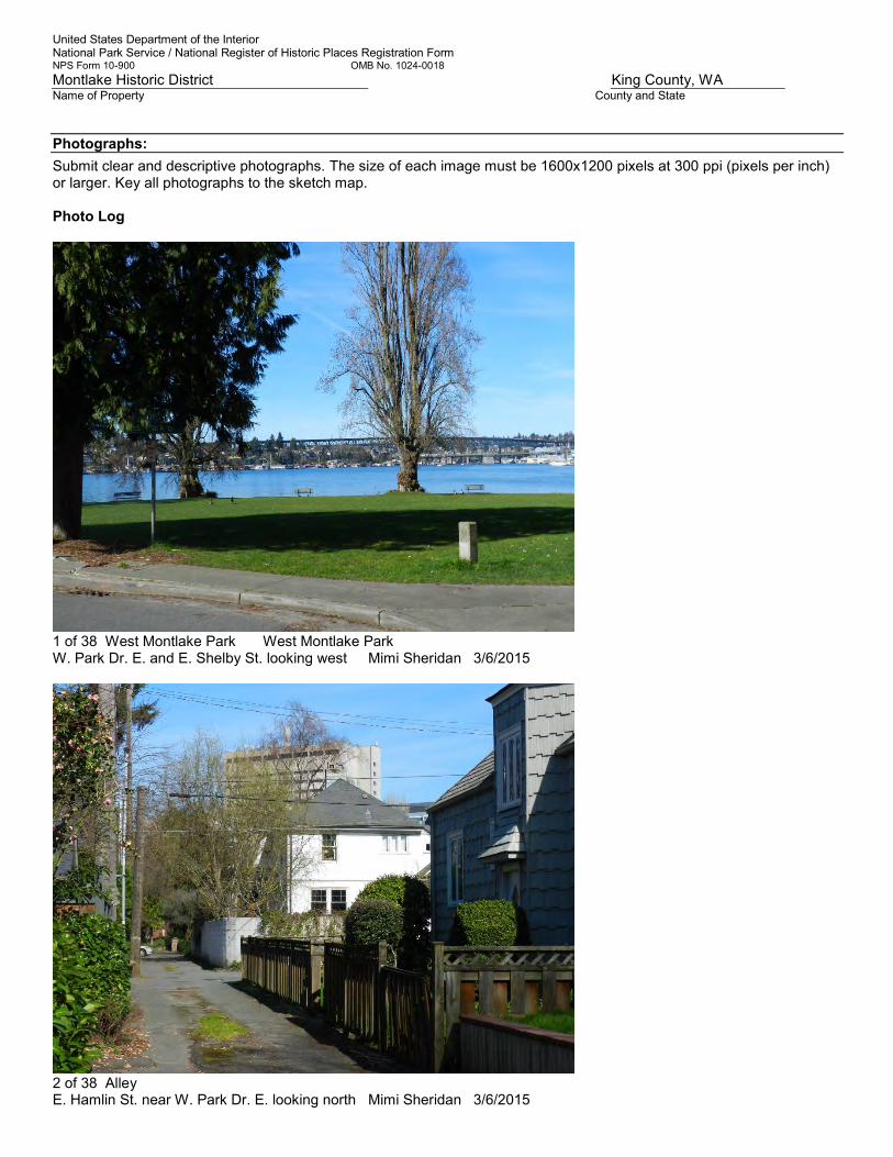
United States Department of the Interior National Park Service / National Register of Historic Places Registration Form NPS Form 10-900 OMB No. 1024-0018
Montlake Historic District King County, WA Name of Property County and State
Photographs:
Submit clear and descriptive photographs. The size of each image must be 1600x1200 pixels at 300 ppi (pixels per inch) or larger. Key all photographs to the sketch map. Photo Log
1 of 38 West Montlake Park West Montlake Park W. Park Dr. E. and E. Shelby St. looking west Mimi Sheridan 3/6/2015
2 of 38 Alley E. Hamlin St. near W. Park Dr. E. looking north Mimi Sheridan 3/6/2015

United States Department of the Interior National Park Service / National Register of Historic Places Registration Form NPS Form 10-900 OMB No. 1024-0018
Montlake Historic District King County, WA Name of Property County and State
3 Streetscape Streetscape E. Hamlin St. from W. Park Dr. E. looking east Mimi Sheridan 3/6/2015
4 of 38 Streetscape Streetscape E. Shelby St. from W. Park Dr. E. looking east Mimi Sheridan 3/6/2015

United States Department of the Interior National Park Service / National Register of Historic Places Registration Form NPS Form 10-900 OMB No. 1024-0018
Montlake Historic District King County, WA Name of Property County and State
5 of 38 Streetscape E. Shelby St. east of Montlake Blvd. E. looking west Mimi Sheridan 3/6/2015
6 of 38 Alleyscape E. North St. from 24th Ave. E. looking west Mimi Sheridan 3/6/2015

United States Department of the Interior National Park Service / National Register of Historic Places Registration Form NPS Form 10-900 OMB No. 1024-0018
Montlake Historic District King County, WA Name of Property County and State
7 of 38 2445 E. Lake Washington Blvd Bowles Residence Primary façade looking south Mimi Sheridan 3/6/2015
8 of 38 2433 E. Lake Washington Blvd Bow Residence Primary façade looking south Mimi Sheridan 3/6/2015

United States Department of the Interior National Park Service / National Register of Historic Places Registration Form NPS Form 10-900 OMB No. 1024-0018
Montlake Historic District King County, WA Name of Property County and State
9 of 38 2612 25th Ave. E. Holden Residence Primary façade looking west Connie Gray 3/4/2015
10 of 38 2220 E. Roanoke St. Peterson Residence Primary façade looking north Mimi Sheridan 2/21/2014
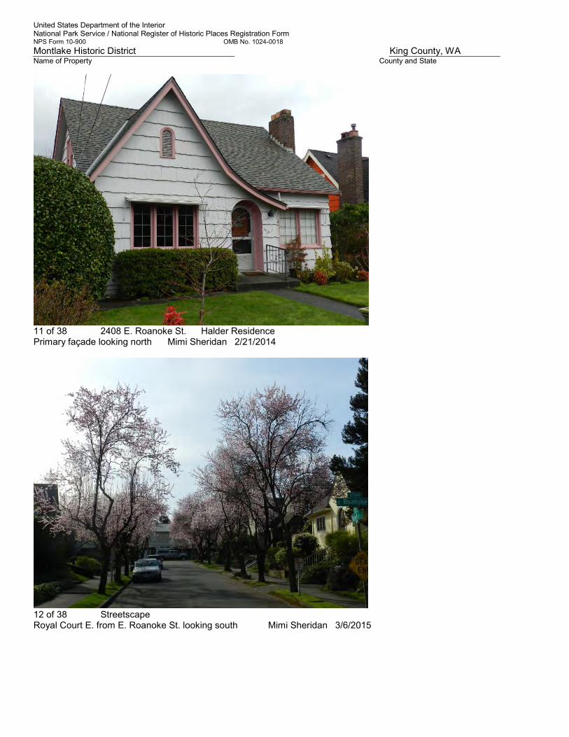
United States Department of the Interior National Park Service / National Register of Historic Places Registration Form NPS Form 10-900 OMB No. 1024-0018
Montlake Historic District King County, WA Name of Property County and State
11 of 38 2408 E. Roanoke St. Halder Residence Primary façade looking north Mimi Sheridan 2/21/2014
12 of 38 Streetscape Royal Court E. from E. Roanoke St. looking south Mimi Sheridan 3/6/2015

United States Department of the Interior National Park Service / National Register of Historic Places Registration Form NPS Form 10-900 OMB No. 1024-0018
Montlake Historic District King County, WA Name of Property County and State
13 of 38 2009 E. Louisa Coles Residence Primary façade looking south Jennifer Meisner 3/28/2014
14 of 38 1924 E. Miller St. Stevenson Residence Primary façade looking northwest Jennifer Meisner 3/4/2014

United States Department of the Interior National Park Service / National Register of Historic Places Registration Form NPS Form 10-900 OMB No. 1024-0018
Montlake Historic District King County, WA Name of Property County and State
15 of 38 Streetscape 20th Ave. E. from E. Miller ST. looking northwest Connie Gray 3/4/2015
16 of 38 1618 E. Calhoun St. Montlake Playfield Tudor Building South façade looking northwest Connie Gray 3/4/2015
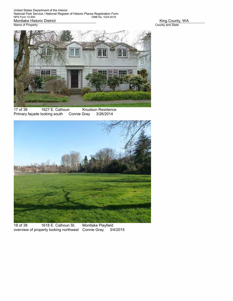
United States Department of the Interior National Park Service / National Register of Historic Places Registration Form NPS Form 10-900 OMB No. 1024-0018
Montlake Historic District King County, WA Name of Property County and State
17 of 38 1627 E. Calhoun Knudson Residence Primary façade looking south Connie Gray 3/26/2014
18 of 38 1618 E. Calhoun St. Montlake Playfield overview of property looking northwest Connie Gray 3/4/2015

United States Department of the Interior National Park Service / National Register of Historic Places Registration Form NPS Form 10-900 OMB No. 1024-0018
Montlake Historic District King County, WA Name of Property County and State
19 of 38 2405 22nd. Ave. E. Montlake School northeast corner/entry looking southwest Connie Gray 3/4/2015
20 of 38 Streetscape Streetscape 16th Avenue E. from McGraw St. looking northwest Connie Gray 3/4/2015

United States Department of the Interior National Park Service / National Register of Historic Places Registration Form NPS Form 10-900 OMB No. 1024-0018
Montlake Historic District King County, WA Name of Property County and State
21 of 38 1621 E. McGraw St. Phillips Residence Primary façade looking south Connie Gray 4/7/2014
22 of 38 Streetscape McGraw St. from 20th Ave. E. looking southwest Connie Gray 3/4/2015

United States Department of the Interior National Park Service / National Register of Historic Places Registration Form NPS Form 10-900 OMB No. 1024-0018
Montlake Historic District King County, WA Name of Property County and State
23 of 38 Streetscape E. McGraw St. from 25th Ave. E. looking northeast Mimi Sheridan 3/6/2015
24 of 38 2507 E. McGraw St. Skinner Residence Primary façade looking south Connie Gray 2/27/2014

United States Department of the Interior National Park Service / National Register of Historic Places Registration Form NPS Form 10-900 OMB No. 1024-0018
Montlake Historic District King County, WA Name of Property County and State
25 of 38 Streetscape 24th Ave. E. from E. Lynn Street looking northwest Connie Gray 3/4/2015
26 of 38 2429 E. Lynn St Todd Residence Primary façade looking south Jennifer Meisner 5/6/2014

United States Department of the Interior National Park Service / National Register of Historic Places Registration Form NPS Form 10-900 OMB No. 1024-0018
Montlake Historic District King County, WA Name of Property County and State
27 of 38 2528 E. Lynn St. Nelson Residence Primary façade looking north Mimi Sheridan 2/15/2015
28 of 38 Streetscape ("Victoria Village") Blaine St. from 22nd Ave E. looking northwest Connie Gray 3/4/2015

United States Department of the Interior National Park Service / National Register of Historic Places Registration Form NPS Form 10-900 OMB No. 1024-0018
Montlake Historic District King County, WA Name of Property County and State
29 of 38 2111 22nd Ave. E. Gilbertson Residence Primary façade looking northwest Connie Gray 3/4/2015
30 of 38 Streetscape Newton St. from 22nd Ave. E. looking northwest Connie Gray 3/4/2015

United States Department of the Interior National Park Service / National Register of Historic Places Registration Form NPS Form 10-900 OMB No. 1024-0018
Montlake Historic District King County, WA Name of Property County and State
31 of 38 2022 24th Ave. E. Waller Residence Primary façade looking southeast Mimi Sheridan 10/27/2014
32 of 38 2003 25th Ave. E. Bryant Residence Primary façade looking west Mimi Sheridan 10/27/2014

United States Department of the Interior National Park Service / National Register of Historic Places Registration Form NPS Form 10-900 OMB No. 1024-0018
Montlake Historic District King County, WA Name of Property County and State
33 of 38 Streetscape 25th Ave. E. north of Boyer Ave. E. looking north Mimi Sheridan 3/6/2015
34 of 38 1656 E. Interlaken Blvd. , Hyde Residence Primary façade looking northeast Mimi Sheridan 5/15/2014

United States Department of the Interior National Park Service / National Register of Historic Places Registration Form NPS Form 10-900 OMB No. 1024-0018
Montlake Historic District King County, WA Name of Property County and State
35 of 38 2030 19th Ave E. Shapiro Residence Primary façade looking Southeast Mimi Sheridan 4/25/2014
36 of 38 Streetscape E. Eaton Pl. from 21st Ave. E. looking west Mimi Sheridan 3/6/2015

United States Department of the Interior National Park Service / National Register of Historic Places Registration Form NPS Form 10-900 OMB No. 1024-0018
Montlake Historic District King County, WA Name of Property County and State
37 of 38 Interlaken Park 21st Ave. E. and E. Eaton Pl. looking south Mimi Sheridan 3/6/2015
38 of 38 2616 E. Interlaken Blvd. Residence Primary façade looking north Mimi Sheridan 2/15/2015 Paperwork Reduction Act Statement: This information is being collected for applications to the National Register of Historic Places to nominate properties for listing or determine eligibility for listing, to list properties, and to amend existing listings. Response to this request is required to obtain a benefit in accordance with the National Historic Preservation Act, as amended (16 U.S.C.460 et seq.). Estimated Burden Statement: Public reporting burden for this form is estimated to average 18 hours per response including time for reviewing instructions, gathering and maintaining data, and completing and reviewing the form. Direct comments regarding this burden estimate or any aspect of this form to the Office of Planning and Performance Management. U.S. Dept. of the Interior, 1849 C. Street, NW, Washington, DC.
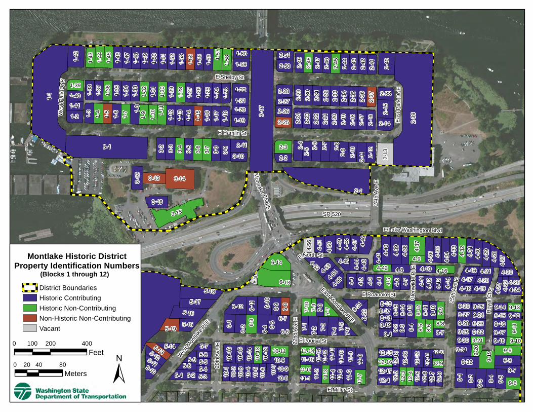
E Hamlin St
Glen
wilde
Pl E
25th
Ave E
22nd
Ave E
East Montlake Pl E
20th
Ave E
E Louisa St
E Shelby St
West Mont
lake P
l E
Roy a
lCt E
ENorth St
SR 520
East
Par k
DrE
West
Park
DrE
24th
Ave E
E Miller St
E Roanoke St
Montlake Blvd E
E Lake Washington Blvd
9-209-31
9-32
9-1 9-2 9-3 9-4 9-5
9-79-89-1
9 9-9
3-12
19-18
3-17
2-13-143-13
3-163-15
19-17
4-52 4-534-5
44-5
5 4-1 4-2 4-3 4-4 4-5 4-6 4-7
4-84-42
4-41
4-43
4-444-45
4-11
4-12
4-13
4-14
4-10 4-16
4-184-17
4-16 4-214-20
4-19 4-244-23 4-25
4-26
4-22
9-309-299-289-279-26 9-25
9-249-239-229-21 9-18 9-10
9-179-169-159-14 9-13
9-12
9-11
1-1
1-42
1-43
1-44
1-45
1-46
1-47
1-48
1-49
1-50
1-51
1-52
1-53
1-54
1-55
1-56 1-5
71-5
8 1-601-59
1-391-40 1-3
81-3
71-3
61-3
51-3
41-3
31-3
21-3
11-3
01-2
91-2
81-2
71-2
61-2
51-2
41-2
3 1-221-211-201-191-1
81-1
71-1
61-1
51-1
41-1
31-1
21-11
1-10
1-91-8
1-71-61-51-41-31-21-41
3-1 3-2 3-3 3-4 3-5 3-6 3-7 3-8 3-9 3-103-11
2-22-3 2-4
2-52-6 2-7 2-8
2-9 2-10
2-11 2-1
2
2-13
2-272-26
2-28
2-29
2-30
2-31
2-32
2-33
2-34
2-35
2-36
2-37 2-38
2-15
2-142-16
2-17
2-19
2-18
2-20
2-21
2-22
2-23
2-24
2-25
2-512-50 2-4
92-4
82-4
72-4
62-4
52-4
42-4
32-4
22-4
1
2-40
2-39
4-56
4-51
4-50 4-49
4-48
4-47 4-4
6
8-178-16
8-18 8-15
8-14
8-13
7-2 7-3 7-4 7-5 7-6
6-12 6-11 6-1
06-9 6-8
6-1 6-26-3
6-4 6-5
6-7
6-6
5-185-17
5-155-19
5-16
5-145-135-115-12
5-105-9
5-75-65-55-8
5-1 5-25-45-3
10-16
10-15
10-14
10-13
10-12
10-910-11
10-1
10-2
10-3
10-4
10-5
10-6 10
-7
10-810-9
11-1511-14
11-13
11-12 11-11
11-10 11-9
11-1611-1 11
-211
-311
-4
11-8
11-5
11-6
11-7
12-1512-16 12
-1412
-1312
-1212
-11
12-10
12-912-1712-1 12
-212
-312
-412
-5
12-7
12-6
12-8
4-40
4-39
4-38 4-3
7
4-9 4-36 4-3
5
4-32
4-31
4-30
4-29
4-28
4-274-3
4 4-33
6-15
6-14
6-13
9-6
8-12
8-11
8-10
8-9
8-198-1 8-38-2 8-4 8-5 8-6
8-88-7
7-10
7-9 7-8 7-7 8-21
8-20
7-1
±0 200 400100
Feet0 40 8020
Meters
Montlake Historic DistrictProperty Identification Numbers
District BoundariesHistoric ContributingHistoric Non-ContributingNon-Historic Non-ContributingVacant
(Blocks 1 through 12)

19th Ave E
15thAve E
Interlaken Dr E
23rd AveE
E Lynn St
E Eaton Pl
Boyer Ave E E Newton St
20th
Ave E
22n
d Ave
E
21st Av
e E
16th
AveE
18th
Ave E
West Mont
lake P
l EEInterlaken Blvd
E Miller St
E McGraw St
E Calhoun St
E Blaine St
34-834-
934-1034-
1134-12
34-14
34-18
34-1634-
17
35-12
35-13
35-14
35-1535-135-2
19-18
19-16
19-17
35-3
35-4
35-5
35-6 35-835-
7 36-
25
34-5
34-334-4
34-20
34-19
34-2
34-2134-
22
36-22
35-11
3 5-9
35-10
13-12
34-1334-15
34-634-1
14-16
14-15
14-14
14-13
14-12
14-11
14-10 14
-9
14-8
14-1
14-2
14-3
14-4
14-5
14- 6
1 4-7
13-1513-16 13
-1413
-13
13-1013-11
13-1713-1 13-2
13-3
13-4
13-5
13-6
13-7
13-813-9
21-18
21-17
21-16
21-15
21-14
29-18 29-16
29-15
29-14
2 9-1 3
2 9-1 2
29- 11
29-10
29-1
29-2
29-3
29-4
29-5
29- 6
29- 7
29-8
2 9-9
20-14
20-15
20-13
20-12
20-11 20-920-8
20-10
20-1
20-2
20-3
20-4
20-5
20-6
20-7
28-15
28-14
28-13
28-12
28-11 28-10
28-9
28-1
28- 2
28-3
28- 4
28-5
28-6 28-8
28-7
27-1727-18 27
-1627
-1527
-1427
-1 327
-12 27-1127-10
27-1927-1 27
-227
-327
-427
-527
-627
-727-827-9
19-15
19-14
19-13
19-12
19-11
19-10 19-9
19-1
19-2
19-3
19-4
19-5
19-6
19-7
19-8
18-1218-11
18-10
18-4
18-9
18-5
18-8
18-7
18- 1
18- 2
18-3
18-6
26-10 26-9
26-1226-626-7
26-3 26-2
26-5
37-18
37-3137-19
37-2037-30
37-21
37-2237-23 37-2937-24 37-28
37-2537-26
37-27
37-17 37-16
37-15
37-14
37-13
37-12 37-10
37-937-837-737-637-537-4
37-337-2
37-1
36-19
36-18
36-17
36-16
36-15
36-14
36-
13
36-12
36-11
36-10
36-9
36-8
36-7
36-6
36-5
36-4
36-3
36-2
36-21 36-2036-23
36-26
36-24
36-27
36-28
36-29 36-30
36-31 36-33
36-32
36-34
36-35
36-36
36-37
36-38
36-40
36-41
36-42
36-1
43-17
43-16
43-25
43-26
43-27
43-28
43-29
43-30
43-31
43-1
37-11
36-39
34-7
21-13
21-12
21-11
21-10
21-2
21-1
21-3
21-5
21-4
21-6
21-7
21-8
21-9
22-1
30-15
30-14
30-13
30-12
30-11
30-10
30-830-9
30-1 30-2
30-3
30-4
30-5 30-7
30-6
29-17
43-15
43-14
43-13
43-12
43-11
43-10
43-9
43-8
43-7
43-6
43-5
43-4
43-3
43-2
43-19
43-20
43-21
43-22
43-23
43-24
±0 200 400100
Feet0 40 8020
Meters
Montlake Historic DistrictProperty Identification Numbers
Historic ContributingHistoric Non-ContributingNon-Historic Non-ContributingVacant
(Blocks 13, 14, 18 thru 22, 26 thru 30, 34 thru 37, 43)

19th Ave E
21st Av
e E23rd Ave E
E Eaton Pl
18th
Ave E
E Newton St
InterlakenDr E
25th
Ave E
E How
e St
22nd
AveE
Boyer Ave E
24th Ave E
20th
Ave E
E Boston St
EInterlaken Blvd
E Miller St
E Lynn St
E McGraw St
E Calhoun St
26th
Ave E
E Blaine St
42-142-242-
342-442-
542-642-
742-8
42-1142-10 42-9
42-1542-
1642-1742-
18
42-1442-1342-12
42-21
42-3942-
4042-4142-
4242-43
42-4442-35
42-3642-3842-37
42-2242-
2342-2442-
2542-2642-2742-2842-
29
42-3142-32
42-30
42-4542-
4742-48
42-33 42-4642-34
17-14
17-13
17-12
17-11
17-10 17-8
17-9
17-1
17-15
17-2 17-3
17-4
17-5
17-617-7
16-15
16-14
16-13
16-12
16-11
16-10
16-8
16-9
16-1616-1 16
-216
-316
-416
-516
-616
-7
15-16
15-15
15-14
15-13
15-12 15-11 15-10
15-9
15-1
15-2
15-3
15-4
15-5
15-6
15-7
15-8
23-13
23-11
23-12
23-10 23-9
23-8
23-6
23-7
23-1423-1 23
-223
-323
-423
-5
24-1424-15 24
-1324
-1224
-1124
-10 24-924-8
24-124-16
24-2
24-3
24-4
24-5 24-7
24-6
25-15
25-14
25-13
25-12
25-11
25-10 25-9
25-1
25-2
25-3
25-5
25-4
25-6
25-7
25-8
33-17
33-16
33-15
33-14
33-13
33-12
33-11
33-10
33-9
33-1
33-2
33-3
33-4
33-5
33-6
33-7
33-8
32-13
32-12
32-11
32-10 32-9 32
-8
32-1 32-2
32-3 32
-532
-432
-6
31-16
31-15
31-14
31-13
31-12
31-11
31-931-10
31-1
31-2
31-3
31-4
31-5 31-6 31-8
31-7
39-25
39-24
39-23
39-22
39-21
39-20
39-13
39-14
39-15
39-16 39-18
39-17
39-19
39-11
39-10
39-9 39
-8 39-739-639-5
39-1239-1 39-3
39-4
39-2
40-1340-12
40-1140-1040-940-840-740-640-540-440-340-2
40-1740-1640-15
40-14 41-1241-1141-1041-941-841-741-641-541-441-341-241-1
38-21 38-2238-2338-2438-2538-2638-2738-2838-2938-3038-3138-3238-3338-34
38-3538-36
38-3738-3838-3938-40
38-4138-42
38-2038-1938-1838-1738-1638-4338-1438-1338-1238-11
38-1038-938-838-738-6
38-538-438-3
38-1
38-2
48-17
48-18
48-16
48-15
48-14
48-13
48-12
48-11
48-10
48-9
48-8
48-7
48-6 48-3
48-5
48-4
48-1
48-2
40-1 40-2640-25
40-2440-23
40-2240-21
40-2040-19
40-18
West Montlake Pl E
42-1942-20
42-49
32-7±
0 200 400100Feet
0 40 8020Meters
Montlake Historic DistrictProperty Identification Numbers
District BoundariesHistoric ContributingHistoric Non-ContributingNon-Historic Non-ContributingVacant
(Blocks 15 thru 17, 23 thru 25, 31 thru 33, 38 thru 42, 48)

19th Ave E21s
t Ave E
23rd Ave E
E Eaton Pl
E Newton St
25th
Ave E
Boyer Ave E
22nd A
ve E
20th A
ve E
26th Av
eE
E How
e St
E Boston St
24th Ave E
E Blaine St
Lake Washington Blvd E
47-447-547-647-747-847-9
47-1047-1147-12
47-1347-14
47-15
46-146-2
46-346-446-57 46-5
46-646-7
46-846-946-1046-1146-1246-1346-1446-48
46-4946-5046-5146-5246-5346-5446-55
46-56
45-1
45-39
45-38
45-3745-3645-3545-3445-5
45-445-345-2
50-6
50-750-7
50-550-
450-350-
250-1
50-16
50-1550-1450-13
50-1250-1150-1050-
950-8
50-17
47-147-247-3
50-18 50-20
47-3147-3047-2947-28
47-2747-2647-2547-2447-2347-2247-2147-2047-1947-1847-1747-16
46-3346-3446-3546-3646-3746-3846-3946-4046-4146-4246-43
46-4446-4546-4646-47 46-15
46-1646-1746-1846-1946-2046-21
46-2146-2346-2446-2546-2646-2746-2846-2946-3046-31
46-3245-1945-1845-1745-1645-1545-1445-1345-1245-1145-1045-9
45-845-7
45-6 45-3345-3245-3145-3045-2945-2845-2745-2645-2545-2445-2345-2245-2145-20
44-22
44-23
44-24
44-25
44-26
44-27
44-29
44-30
44-28
44-31
44-32
44-33
44-21
44-20
44-19
44-18
44-17
44-16
44-15
44-14
44-13
44-1244-1144-10
44-944-8
44-744-6
44-444-2
44-1
49-1349-1249-1149-1049-949-849-749-649-549-449-349-2
49-1
50-19
44-544-3
±0 200 400100
Feet0 40 8020
Meters
Montlake Historic DistrictProperty Identification Numbers
District BoundariesHistoric ContributingHistoric Non-ContributingNon-Historic Non-ContributingVacant
(Blocks 44 thru 47, 49, 50)

Montlake Historic District Buildings Listed by Address
Table by Address, Page 1
Building Address ID #
2412 15TH AVE E 18-12
2416 15TH AVE E 18-11
2311 16TH AVE E 26-6
2306 16TH AVE E 27-19
2312 16TH AVE E 27-18
2316 16TH AVE E 27-17
2016 18TH AVE E 34-15
2307 18TH AVE E 27-9
2311 18TH AVE E 27-10
2315 18TH AVE E 27-11
2316 18TH AVE E 28-15
2000 19TH AVE E 42-30
2001 19TH AVE E 34-3
2006 19TH AVE E 42-31
2007 19TH AVE E 34-4
2011 19TH AVE E 34-6
2012 19TH AVE E 42-32
2018 19TH AVE E 42-33
2019 19TH AVE E 34-5
2024 19TH AVE E 42-49
2030 19TH AVE E 42-48
2114 19TH AVE E 43-18
2210 19TH AVE E 36-24
2216 19TH AVE E 36-23
2303 19TH AVE E 28-7
2307 19TH AVE E 28-8
2312 19TH AVE E 29-18
Building Address ID #
2315 19TH AVE E 28-9
2318 19TH AVE E 29-17
2323 19TH AVE E 28-10
2401 19TH AVE E 20-7
2411 19TH AVE E 20-8
2415 19TH AVE E 20-9
2454 19TH AVE E 13-1
2456 19TH AVE E 13-17
1950 20TH AVE E 42-35
1951 20TH AVE E 42-34
1955 20TH AVE E 42-46
1956 20TH AVE E 42-44
2455 20TH AVE E 13-9
2461 20TH AVE E 13-10
2465 20TH AVE E 13-11
2505 20TH AVE E 5-4
2509 20TH AVE E 5-5
2514 20TH AVE E 5-6
2515 20TH AVE E 5-7
2519 20TH AVE E 6-1
2552 20TH AVE E 10-16
1903 21ST AVE E 42-22
1904 21ST AVE E 42-21
1908 21ST AVE E 42-20
1912 21ST AVE E 42-19
1951 21ST AVE E 42-37
1955 21ST AVE E 42-38

Montlake Historic District Buildings Listed by Address
Table by Address, Page 2
Building Address ID #
1963 21ST AVE E 42-39
1900 22ND AVE E 42-9
1901 22ND AVE E 42-12
1905 22ND AVE E 42-13
1906 22ND AVE E 42-10
1908 22ND AVE E 42-11
1909 22ND AVE E 42-14
1961 22ND AVE E 43-2
2022 22ND AVE E 37-23
2101 22ND AVE E 36-2
2102 22ND AVE E 44-21
2111 22ND AVE E 36-3
2205 22ND AVE E 37-4
2211 22ND AVE E 37-5
2215 22ND AVE E 37-6
2217 22ND AVE E 37-7
2220 22ND AVE E 37-20
2221 22ND AVE E 37-8
2222 22ND AVE E 37-19
2227 22ND AVE E 37-9
2229 22ND AVE E 37-10
2235 22ND AVE E 37-11
2303 22ND AVE E 30-6
2304 22ND AVE E 31-1
2307 22ND AVE E 30-7
2313 22ND AVE E 30-8
2314 22ND AVE E 31-16
Building Address ID #
2317 22ND AVE E 30-9
2409 22ND AVE E 22-1
2453 22ND AVE E 14-7
2461 22ND AVE E 14-8
2501 22ND AVE E 11-1
2502 22ND AVE E 11-16
2506 22ND AVE E 11-15
2507 22ND AVE E 7-1
2511 22ND AVE E 6-6
2512 22ND AVE E 6-7
2515 22ND AVE E 6-8
2550 22ND AVE E 6-13
2553 22ND AVE E 10-8
2557 22ND AVE E 10-9
2565 22ND AVE E 10-9
2605 22ND AVE E 10-11
1802 23RD AVE E 49-2
1808 23RD AVE E 49-3
1810 23RD AVE E 49-4
1817 23RD AVE E 44-2
1818 23RD AVE E 49-6
1821 23RD AVE E 44-4
1822 23RD AVE E 49-7
1826 23RD AVE E 49-8
1827 23RD AVE E 44-6
1831 23RD AVE E 44-7
1835 23RD AVE E 44-8

Montlake Historic District Buildings Listed by Address
Table by Address, Page 3
Building Address ID #
1841 23RD AVE E 44-9
1849 23RD AVE E 44-10
1853 23RD AVE E 44-11
1857 23RD AVE E 44-12
1863 23RD AVE E 44-13
1871 23RD AVE E 44-14
2004 23RD AVE E 38-1
2005 23RD AVE E 37-27
2006 23RD AVE E 38-2
2012 23RD AVE E 38-3
2015 23RD AVE E 37-26
2016 23RD AVE E 38-4
2017 23RD AVE E 37-25
2019 23RD AVE E 37-28
2020 23RD AVE E 38-5
2024 23RD AVE E 38-6
2025 23RD AVE E 37-29
2026 23RD AVE E 38-7
2027 23RD AVE E 37-22
2032 23RD AVE E 38-8
2035 23RD AVE E 37-21
2036 23RD AVE E 38-9
2040 23RD AVE E 38-10
2041 23RD AVE E 37-30
2043 23RD AVE E 37-31
2044 23RD AVE E 38-11
2047 23RD AVE E 37-18
Building Address ID #
2048 23RD AVE E 38-12
2052 23RD AVE E 38-13
2056 23RD AVE E 38-14
2060 23RD AVE E 38-43
2064 23RD AVE E 38-16
2068 23RD AVE E 38-17
2070 23RD AVE E 38-18
2074 23RD AVE E 38-19
2080 23RD AVE E 38-20
1806 24TH AVE E 45-2
1808 24TH AVE E 45-3
1816 24TH AVE E 45-4
1820 24TH AVE E 45-5
1823 24TH AVE E 49-5
1824 24TH AVE E 45-6
1830 24TH AVE E 45-7
1834 24TH AVE E 45-8
1839 24TH AVE E 49-9
1840 24TH AVE E 45-9
1843 24TH AVE E 49-10
1844 24TH AVE E 45-10
1847 24TH AVE E 49-11
1850 24TH AVE E 45-11
1851 24TH AVE E 49-12
1854 24TH AVE E 45-12
1855 24TH AVE E 49-13
1860 24TH AVE E 45-13
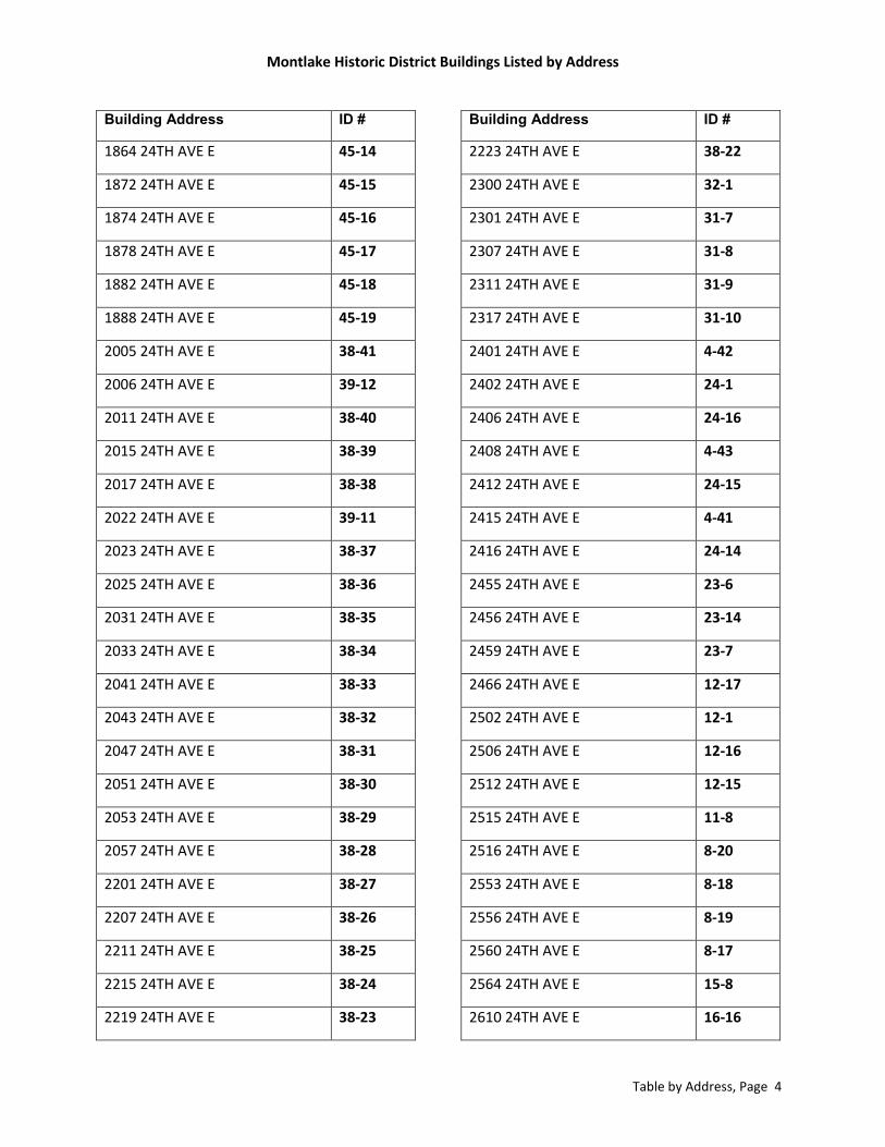
Montlake Historic District Buildings Listed by Address
Table by Address, Page 4
Building Address ID #
1864 24TH AVE E 45-14
1872 24TH AVE E 45-15
1874 24TH AVE E 45-16
1878 24TH AVE E 45-17
1882 24TH AVE E 45-18
1888 24TH AVE E 45-19
2005 24TH AVE E 38-41
2006 24TH AVE E 39-12
2011 24TH AVE E 38-40
2015 24TH AVE E 38-39
2017 24TH AVE E 38-38
2022 24TH AVE E 39-11
2023 24TH AVE E 38-37
2025 24TH AVE E 38-36
2031 24TH AVE E 38-35
2033 24TH AVE E 38-34
2041 24TH AVE E 38-33
2043 24TH AVE E 38-32
2047 24TH AVE E 38-31
2051 24TH AVE E 38-30
2053 24TH AVE E 38-29
2057 24TH AVE E 38-28
2201 24TH AVE E 38-27
2207 24TH AVE E 38-26
2211 24TH AVE E 38-25
2215 24TH AVE E 38-24
2219 24TH AVE E 38-23
Building Address ID #
2223 24TH AVE E 38-22
2300 24TH AVE E 32-1
2301 24TH AVE E 31-7
2307 24TH AVE E 31-8
2311 24TH AVE E 31-9
2317 24TH AVE E 31-10
2401 24TH AVE E 4-42
2402 24TH AVE E 24-1
2406 24TH AVE E 24-16
2408 24TH AVE E 4-43
2412 24TH AVE E 24-15
2415 24TH AVE E 4-41
2416 24TH AVE E 24-14
2455 24TH AVE E 23-6
2456 24TH AVE E 23-14
2459 24TH AVE E 23-7
2466 24TH AVE E 12-17
2502 24TH AVE E 12-1
2506 24TH AVE E 12-16
2512 24TH AVE E 12-15
2515 24TH AVE E 11-8
2516 24TH AVE E 8-20
2553 24TH AVE E 8-18
2556 24TH AVE E 8-19
2560 24TH AVE E 8-17
2564 24TH AVE E 15-8
2610 24TH AVE E 16-16
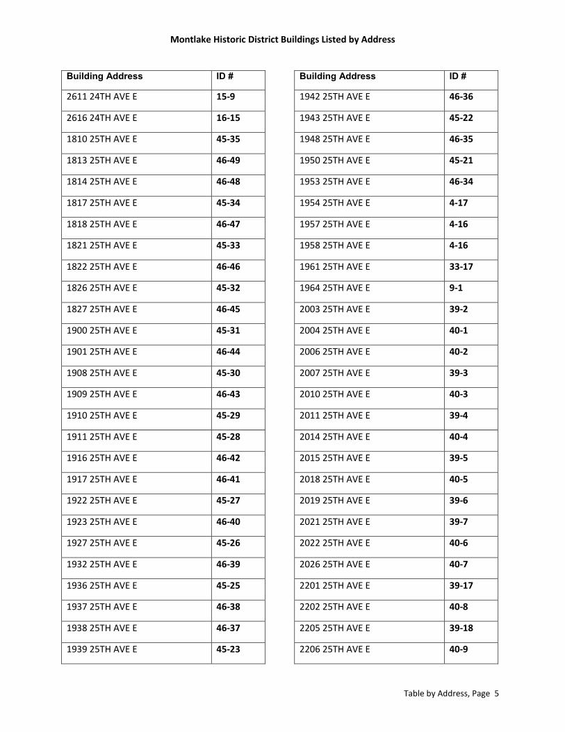
Montlake Historic District Buildings Listed by Address
Table by Address, Page 5
Building Address ID #
2611 24TH AVE E 15-9
2616 24TH AVE E 16-15
1810 25TH AVE E 45-35
1813 25TH AVE E 46-49
1814 25TH AVE E 46-48
1817 25TH AVE E 45-34
1818 25TH AVE E 46-47
1821 25TH AVE E 45-33
1822 25TH AVE E 46-46
1826 25TH AVE E 45-32
1827 25TH AVE E 46-45
1900 25TH AVE E 45-31
1901 25TH AVE E 46-44
1908 25TH AVE E 45-30
1909 25TH AVE E 46-43
1910 25TH AVE E 45-29
1911 25TH AVE E 45-28
1916 25TH AVE E 46-42
1917 25TH AVE E 46-41
1922 25TH AVE E 45-27
1923 25TH AVE E 46-40
1927 25TH AVE E 45-26
1932 25TH AVE E 46-39
1936 25TH AVE E 45-25
1937 25TH AVE E 46-38
1938 25TH AVE E 46-37
1939 25TH AVE E 45-23
Building Address ID #
1942 25TH AVE E 46-36
1943 25TH AVE E 45-22
1948 25TH AVE E 46-35
1950 25TH AVE E 45-21
1953 25TH AVE E 46-34
1954 25TH AVE E 4-17
1957 25TH AVE E 4-16
1958 25TH AVE E 4-16
1961 25TH AVE E 33-17
1964 25TH AVE E 9-1
2003 25TH AVE E 39-2
2004 25TH AVE E 40-1
2006 25TH AVE E 40-2
2007 25TH AVE E 39-3
2010 25TH AVE E 40-3
2011 25TH AVE E 39-4
2014 25TH AVE E 40-4
2015 25TH AVE E 39-5
2018 25TH AVE E 40-5
2019 25TH AVE E 39-6
2021 25TH AVE E 39-7
2022 25TH AVE E 40-6
2026 25TH AVE E 40-7
2201 25TH AVE E 39-17
2202 25TH AVE E 40-8
2205 25TH AVE E 39-18
2206 25TH AVE E 40-9

Montlake Historic District Buildings Listed by Address
Table by Address, Page 6
Building Address ID #
2209 25TH AVE E 39-19
2210 25TH AVE E 40-10
2214 25TH AVE E 40-11
2216 25TH AVE E 40-12
2222 25TH AVE E 40-13
2303 25TH AVE E 32-6
2309 25TH AVE E 32-7
2319 25TH AVE E 32-8
2320 25TH AVE E 24-6
2403 25TH AVE E 24-7
2407 25TH AVE E 24-8
2411 25TH AVE E 24-9
2417 25TH AVE E 17-1
2450 25TH AVE E 16-8
2458 25TH AVE E 17-15
2463 25TH AVE E 17-14
2466 25TH AVE E 46-52
2504 25TH AVE E 45-37
2511 25TH AVE E 12-9
2514 25TH AVE E 9-32
2520 25TH AVE E 46-51
2524 25TH AVE E 45-36
2552 25TH AVE E 46-50
2553 25TH AVE E 8-7
2556 25TH AVE E 9-28
2557 25TH AVE E 8-8
2562 25TH AVE E 9-27
Building Address ID #
2565 25TH AVE E 8-9
2606 25TH AVE E 9-31
2611 25TH AVE E 9-30
2612 25TH AVE E 9-29
1612 26TH AVE E 50-18
2311 26TH AVE E 17-6
2315 26TH AVE E 17-7
2451 26TH AVE E 17-8
2457 26TH AVE E 17-9
2463 26TH AVE E 9-12
2467 26TH AVE E 46-1
2537 26TH AVE E 47-2
1703 26TH AVE E 47-3
1708 26TH AVE E 46-2
1710 26TH AVE E 46-3
1711 26TH AVE E 47-4
1717 26TH AVE E 46-4
1718 26TH AVE E 47-5
1719 26TH AVE E 46-5
1722 26TH AVE E 47-6
1723 26TH AVE E 46-6
1726 26TH AVE E 47-7
1727 26TH AVE E 46-7
1730 26TH AVE E 47-8
1735 26TH AVE E 46-8
1736 26TH AVE E 47-9
1737 26TH AVE E 46-9

Montlake Historic District Buildings Listed by Address
Table by Address, Page 7
Building Address ID #
1738 26TH AVE E 47-10
1739 26TH AVE E 46-10
1742 26TH AVE E 46-11
1743 26TH AVE E 47-11
1747 26TH AVE E 46-12
1748 26TH AVE E 47-12
1751 26TH AVE E 46-13
1752 26TH AVE E 47-13
1755 26TH AVE E 46-14
1756 26TH AVE E 47-14
1759 26TH AVE E 47-15
1760 26TH AVE E 46-15
1770 26TH AVE E 47-16
1901 26TH AVE E 46-16
1902 26TH AVE E 47-17
1905 26TH AVE E 46-17
1906 26TH AVE E 46-18
1907 26TH AVE E 47-18
1911 26TH AVE E 47-19
1912 26TH AVE E 46-19
1914 26TH AVE E 47-20
1915 26TH AVE E 46-20
1918 26TH AVE E 46-21
1919 26TH AVE E 47-21
1923 26TH AVE E 46-21
1924 26TH AVE E 47-22
1927 26TH AVE E 47-23
Building Address ID #
1928 26TH AVE E 46-23
1930 26TH AVE E 47-24
1931 26TH AVE E 46-24
1936 26TH AVE E 47-25
1937 26TH AVE E 46-25
1940 26TH AVE E 46-26
1941 26TH AVE E 47-26
1945 26TH AVE E 46-27
1946 26TH AVE E 47-27
1949 26TH AVE E 46-28
1952 26TH AVE E 47-28
1953 26TH AVE E 46-29
1956 26TH AVE E 47-29
1957 26TH AVE E 46-30
1960 26TH AVE E 47-30
1961 26TH AVE E 46-31
1964 26TH AVE E 47-31
1965 26TH AVE E 46-32
1968 26TH AVE E 33-9
1969 26TH AVE E 33-10
2000 26TH AVE E 41-1
2001 26TH AVE E 40-26
2007 26TH AVE E 40-25
2008 26TH AVE E 41-2
2011 26TH AVE E 40-24
2014 26TH AVE E 41-3
2015 26TH AVE E 40-23

Montlake Historic District Buildings Listed by Address
Table by Address, Page 8
Building Address ID #
2016 26TH AVE E 41-4
2019 26TH AVE E 40-22
2022 26TH AVE E 41-5
2023 26TH AVE E 40-21
2026 26TH AVE E 41-6
2027 26TH AVE E 40-20
2030 26TH AVE E 41-7
2031 26TH AVE E 40-19
2034 26TH AVE E 41-8
2035 26TH AVE E 40-18
2038 26TH AVE E 41-9
2039 26TH AVE E 40-17
2042 26TH AVE E 41-10
2043 26TH AVE E 40-16
2046 26TH AVE E 41-11
2047 26TH AVE E 40-15
2049 26TH AVE E 40-14
1900 E BLAINE ST 36-25
1902 E BLAINE ST 36-26
1904 E BLAINE ST 36-27
1905 E BLAINE ST 43-17
1907 E BLAINE ST 43-16
1908 E BLAINE ST 36-28
1912 E BLAINE ST 36-29
1913 E BLAINE ST 43-15
1915 E BLAINE ST 43-14
1916 E BLAINE ST 36-31
Building Address ID #
1919 E BLAINE ST 43-13
1920 E BLAINE ST 36-32
1921 E BLAINE ST 43-12
1924 E BLAINE ST 36-34
1925 E BLAINE ST 43-11
1928 E BLAINE ST 36-35
1929 E BLAINE ST 43-10
1932 E BLAINE ST 36-36
1933 E BLAINE ST 43-9
1937 E BLAINE ST 43-8
1938 E BLAINE ST 36-37
1941 E BLAINE ST 43-7
1942 E BLAINE ST 36-38
1945 E BLAINE ST 43-6
1946 E BLAINE ST 36-39
1949 E BLAINE ST 43-5
1950 E BLAINE ST 36-40
1953 E BLAINE ST 43-4
1954 E BLAINE ST 36-41
1957 E BLAINE ST 43-3
1958 E BLAINE ST 36-42
2201 E BLAINE ST 48-18
2228 E BLAINE ST 44-29
2232 E BLAINE ST 44-30
2236 E BLAINE ST 44-31
2237 E BLAINE ST 48-7
2240 E BLAINE ST 44-32

Montlake Historic District Buildings Listed by Address
Table by Address, Page 9
Building Address ID #
2244 E BLAINE ST 44-33
2247 E BLAINE ST 48-3
2407 E BOSTON ST 39-10
2410 E BOSTON ST 39-15
2411 E BOSTON ST 39-9
2414 E BOSTON ST 39-16
2415 E BOSTON ST 39-8
1603 BOYER AVE E 50-20
1606 BOYER AVE E 47-1
1617 BOYER AVE E 50-16
1726 BOYER AVE E 46-57
1730 BOYER AVE E 46-56
1736 BOYER AVE E 46-55
1738 BOYER AVE E 46-54
1754 BOYER AVE E 45-39
1800 BOYER AVE E 49-1
1815 BOYER AVE E 44-1
1821 BOYER AVE E 50-3
1914 BOYER AVE E 48-4
1918 BOYER AVE E 48-5
1922 BOYER AVE E 48-6
1926 BOYER AVE E 48-8
1930 BOYER AVE E 48-9
1931 BOYER AVE E 42-1
1934 BOYER AVE E 48-10
1937 BOYER AVE E 42-2
1938 BOYER AVE E 48-11
Building Address ID #
1941 BOYER AVE E 42-3
1942 BOYER AVE E 48-12
1945 BOYER AVE E 42-4
1946 BOYER AVE E 48-13
1948 BOYER AVE E 48-14
1949 BOYER AVE E 42-5
1950 BOYER AVE E 45-38
1953 BOYER AVE E 42-6
1954 BOYER AVE E 48-15
1957 BOYER AVE E 42-7
1958 BOYER AVE E 48-16
1961 BOYER AVE E 42-8
1962 BOYER AVE E 48-17
1964 BOYER AVE E 45-1
2001 BOYER AVE E 42-15
2002 BOYER AVE E 43-1
2005 BOYER AVE E 42-16
2006 BOYER AVE E 43-31
2008 BOYER AVE E 43-30
2009 BOYER AVE E 42-17
2011 BOYER AVE E 42-18
2014 BOYER AVE E 43-29
2018 BOYER AVE E 43-28
2022 BOYER AVE E 43-27
2025 BOYER AVE E 42-40
2026 BOYER AVE E 43-26
2028 BOYER AVE E 43-25

Montlake Historic District Buildings Listed by Address
Table by Address, Page 10
Building Address ID #
2029 BOYER AVE E 42-41
2032 BOYER AVE E 43-24
2033 BOYER AVE E 42-42
2036 BOYER AVE E 43-23
2037 BOYER AVE E 42-43
2040 BOYER AVE E 43-22
2044 BOYER AVE E 43-21
2045 BOYER AVE E 42-45
2048 BOYER AVE E 43-20
2049 BOYER AVE E 42-47
2052 BOYER AVE E 43-19
2100 BOYER AVE E 35-8
2103 BOYER AVE E 34-7
2109 BOYER AVE E 34-8
2115 BOYER AVE E 34-9
2119 BOYER AVE E 34-10
2123 BOYER AVE E 34-11
2127 BOYER AVE E 34-12
2132 BOYER AVE E 35-7
2133 BOYER AVE E 34-13
2138 BOYER AVE E 35-6
2142 BOYER AVE E 35-5
2145 BOYER AVE E 34-14
2147 BOYER AVE E 34-16
2148 BOYER AVE E 35-4
2149 BOYER AVE E 34-17
2156 BOYER AVE E 35-3
Building Address ID #
2157 BOYER AVE E 34-18
2163 BOYER AVE E 34-19
2164 BOYER AVE E 35-2
2167 BOYER AVE E 34-20
2171 BOYER AVE E 34-21
2175 BOYER AVE E 34-22
2302 BOYER AVE E 26-5
2308 BOYER AVE E 26-12
2309 BOYER AVE E 26-2
2315 BOYER AVE E 26-3
2316 BOYER AVE E 26-9
2324 BOYER AVE E 26-10
1515 E CALHOUN ST 18-10
1523 E CALHOUN ST 18-9
1529 E CALHOUN ST 18-8
1531 E CALHOUN ST 18-7
1601 E CALHOUN ST 19-15
1607 E CALHOUN ST 19-14
1611 E CALHOUN ST 19-13
1617 E CALHOUN ST 19-12
1618 E CALHOUN ST 19-16
1618 E CALHOUN ST 19-18
1623 E CALHOUN ST 19-11
1627 E CALHOUN ST 19-10
1633 E CALHOUN ST 19-9
1801 E CALHOUN ST 20-15
1807 E CALHOUN ST 20-14

Montlake Historic District Buildings Listed by Address
Table by Address, Page 11
Building Address ID #
1811 E CALHOUN ST 20-13
1815 E CALHOUN ST 20-12
1821 E CALHOUN ST 20-11
1903 E CALHOUN ST 21-18
1907 E CALHOUN ST 21-17
1908 E CALHOUN ST 13-2
1909 E CALHOUN ST 21-16
1910 E CALHOUN ST 13-3
1914 E CALHOUN ST 13-4
1915 E CALHOUN ST 21-15
1919 E CALHOUN ST 21-14
1920 E CALHOUN ST 13-5
1922 E CALHOUN ST 13-6
1923 E CALHOUN ST 21-13
1926 E CALHOUN ST 13-7
1927 E CALHOUN ST 21-12
1931 E CALHOUN ST 21-11
1932 E CALHOUN ST 13-8
1935 E CALHOUN ST 21-10
2002 E CALHOUN ST 14-1
2008 E CALHOUN ST 14-2
2012 E CALHOUN ST 14-3
2014 E CALHOUN ST 14-4
2020 E CALHOUN ST 14-5
2026 E CALHOUN ST 14-6
2201 E CALHOUN ST 23-13
2202 E CALHOUN ST 15-1
Building Address ID #
2206 E CALHOUN ST 15-2
2207 E CALHOUN ST 23-12
2210 E CALHOUN ST 15-3
2211 E CALHOUN ST 23-11
2215 E CALHOUN ST 23-10
2216 E CALHOUN ST 15-4
2219 E CALHOUN ST 23-9
2220 E CALHOUN ST 15-5
2224 E CALHOUN ST 15-6
2225 E CALHOUN ST 23-8
2228 E CALHOUN ST 15-7
2406 E CALHOUN ST 16-1
2410 E CALHOUN ST 16-2
2411 E CALHOUN ST 24-13
2414 E CALHOUN ST 16-3
2415 E CALHOUN ST 24-12
2420 E CALHOUN ST 16-4
2421 E CALHOUN ST 24-11
2424 E CALHOUN ST 16-5
2425 E CALHOUN ST 24-10
2428 E CALHOUN ST 16-6
2432 E CALHOUN ST 16-7
2501 E CALHOUN ST 25-15
2505 E CALHOUN ST 25-14
2506 E CALHOUN ST 17-2
2509 E CALHOUN ST 25-13
2514 E CALHOUN ST 17-3

Montlake Historic District Buildings Listed by Address
Table by Address, Page 12
Building Address ID #
2515 E CALHOUN ST 25-12
2518 E CALHOUN ST 17-4
2519 E CALHOUN ST 25-11
2522 E CALHOUN ST 17-5
2525 E CALHOUN ST 25-10
2533 E CALHOUN ST 25-9
1911 E EATON PL 42-29
1915 E EATON PL 42-28
1919 E EATON PL 42-27
2003 E EATON PL 42-26
2005 E EATON PL 42-25
2007 E EATON PL 42-24
2010 E EATON PL 42-36
2011 E EATON PL 42-23
2610 GLENWILDE PL E 4-10
2611 GLENWILDE PL E 4-8
2618 GLENWILDE PL E 4-9
1804 E HAMLIN ST 1-2
1807 E HAMLIN ST 3-1
1812 E HAMLIN ST 1-3
1816 E HAMLIN ST 1-4
1822 E HAMLIN ST 1-5
1826 E HAMLIN ST 1-6
1832 E HAMLIN ST 1-7
1836 E HAMLIN ST 1-8
1840 E HAMLIN ST 1-9
1846 E HAMLIN ST 1-10
Building Address ID #
1852 E HAMLIN ST 1-11
1853 E HAMLIN ST 3-2
1856 E HAMLIN ST 1-12
1857 E HAMLIN ST 3-3
1862 E HAMLIN ST 1-13
1863 E HAMLIN ST 3-4
1866 E HAMLIN ST 1-14
1867 E HAMLIN ST 3-5
1872 E HAMLIN ST 1-15
1875 E HAMLIN ST 3-6
1876 E HAMLIN ST 1-16
1877 E HAMLIN ST 3-7
1879 E HAMLIN ST 3-8
1882 E HAMLIN ST 1-17
1885 E HAMLIN ST 3-9
1888 E HAMLIN ST 1-18
1891 E HAMLIN ST 3-10
1893 E HAMLIN ST 3-11
1896 E HAMLIN ST 1-19
2110 E HAMLIN ST 2-24
2111 E HAMLIN ST 2-4
2112 E HAMLIN ST 2-23
2117 E HAMLIN ST 2-5
2121 E HAMLIN ST 2-6
2122 E HAMLIN ST 2-22
2127 E HAMLIN ST 2-7
2128 E HAMLIN ST 2-21

Montlake Historic District Buildings Listed by Address
Table by Address, Page 13
Building Address ID #
2130 E HAMLIN ST 2-20
2133 E HAMLIN ST 2-8
2136 E HAMLIN ST 2-19
2137 E HAMLIN ST 2-9
2141 E HAMLIN ST 2-10
2142 E HAMLIN ST 2-18
2146 E HAMLIN ST 2-17
2147 E HAMLIN ST 2-11
2150 E HAMLIN ST 2-16
2151 E HAMLIN ST 2-12
2160 E HAMLIN ST 2-14
2020 E HOWE ST 36-14
2024 E HOWE ST 36-13
2025 E HOWE ST 36-30
2029 E HOWE ST 36-33
2077 E HOWE ST 36-1
2201 E HOWE ST 44-22
2205 E HOWE ST 44-23
2209 E HOWE ST 44-24
2215 E HOWE ST 44-25
2219 E HOWE ST 44-26
2223 E HOWE ST 44-27
2231 E HOWE ST 44-28
2268 E HOWE ST 44-5
2269 E HOWE ST 48-2
2271 E HOWE ST 48-1
2272 E HOWE ST 44-3
Building Address ID #
2112 E INTERLAKEN BLVD 50-1
2124 E INTERLAKEN BLVD 50-2
2134 E INTERLAKEN BLVD 50-4
2142 E INTERLAKEN BLVD 50-5
2150 E INTERLAKEN BLVD 50-6
2402 E INTERLAKEN BLVD 50-8
2406 E INTERLAKEN BLVD 50-9
2410 E INTERLAKEN BLVD 50-10
2412 E INTERLAKEN BLVD 50-11
2414 E INTERLAKEN BLVD 50-12
2418 E INTERLAKEN BLVD 50-13
2426 E INTERLAKEN BLVD 50-14
2432 E INTERLAKEN BLVD 50-15
2610 E INTERLAKEN BLVD 50-17
2616 E INTERLAKEN BLVD 50-19
1648 E INTERLAKEN BLVD 34-1
1656 E INTERLAKEN BLVD 34-2
2517 LAKE WAHSINGTON BLVD E 9-8
2209 LAKE WASHINGTON BLVD E 4-51
2215 LAKE WASHINGTON BLVD E 4-50
2219 LAKE WASHINGTON BLVD E 4-49
2223 LAKE WASHINGTON BLVD E 4-48
2227 LAKE WASHINGTON BLVD E 4-47
2231 LAKE WASHINGTON BLVD E 4-46
2401 LAKE WASHINGTON BLVD E 4-40
2409 LAKE WASHINGTON BLVD E 4-39
2415 LAKE WASHINGTON BLVD E 4-38

Montlake Historic District Buildings Listed by Address
Table by Address, Page 14
Building Address ID #
2419 LAKE WASHINGTON BLVD E 4-37
2425 LAKE WASHINGTON BLVD E 4-36
2429 LAKE WASHINGTON BLVD E 4-35
2433 LAKE WASHINGTON BLVD E 4-34
2437 LAKE WASHINGTON BLVD E 4-33
2441 LAKE WASHINGTON BLVD E 4-32
2445 LAKE WASHINGTON BLVD E 4-31
2449 LAKE WASHINGTON BLVD E 4-30
2455 LAKE WASHINGTON BLVD E 4-29
2459 LAKE WASHINGTON BLVD E 4-28
2465 LAKE WASHINGTON BLVD E 4-27
2511 LAKE WASHINGTON BLVD E 4-25
2521 LAKE WASHINGTON BLVD E 4-26
2525 LAKE WASHINGTON BLVD E 9-7
2531 LAKE WASHINGTON BLVD E 9-9
2607 LAKE WASHINGTON BLVD E 9-10
2615 LAKE WASHINGTON BLVD E 9-11
1910 E LOUISA ST 5-19
2008 E LOUISA ST 6-2
2009 E LOUISA ST 10-15
2014 E LOUISA ST 6-3
2015 E LOUISA ST 10-14
2019 E LOUISA ST 10-13
2020 E LOUISA ST 6-4
2023 E LOUISA ST 10-12
2026 E LOUISA ST 6-5
2203 E LOUISA ST 11-14
Building Address ID #
2211 E LOUISA ST 11-13
2213 E LOUISA ST 11-12
2217 E LOUISA ST 11-11
2223 E LOUISA ST 11-10
2227 E LOUISA ST 11-9
2206 E LOUISA ST 7-2
2210 E LOUISA ST 7-3
2216 E LOUISA ST 7-4
2220 E LOUISA ST 7-5
2226 E LOUISA ST 7-6
2400 E LOUISA ST 8-1
2408 E LOUISA ST 8-2
2411 E LOUISA ST 12-14
2412 E LOUISA ST 8-3
2415 E LOUISA ST 12-13
2418 E LOUISA ST 8-4
2421 E LOUISA ST 12-12
2422 E LOUISA ST 8-5
2427 E LOUISA ST 12-11
2428 E LOUISA ST 8-6
2433 E LOUISA ST 12-10
1611 E LYNN ST 35-1
1619 E LYNN ST 35-15
1627 E LYNN ST 35-14
1633 E LYNN ST 35-13
1805 E LYNN ST 35-12
1811 E LYNN ST 35-11

Montlake Historic District Buildings Listed by Address
Table by Address, Page 15
Building Address ID #
1819 E LYNN ST 35-10
1825 E LYNN ST 35-9
1901 E LYNN ST 36-22
1905 E LYNN ST 36-21
1909 E LYNN ST 36-20
1917 E LYNN ST 36-19
1921 E LYNN ST 36-18
1925 E LYNN ST 36-17
1927 E LYNN ST 36-16
1931 E LYNN ST 36-15
2001 E LYNN ST 37-17
2004 E LYNN ST 30-1
2007 E LYNN ST 37-16
2010 E LYNN ST 30-2
2011 E LYNN ST 37-15
2012 E LYNN ST 30-3
2015 E LYNN ST 37-14
2019 E LYNN ST 37-13
2020 E LYNN ST 30-4
2021 E LYNN ST 37-12
2024 E LYNN ST 30-5
2206 E LYNN ST 31-2
2210 E LYNN ST 31-3
2304 E LYNN ST 31-4
2310 E LYNN ST 31-5
2314 E LYNN ST 31-6
2401 E LYNN ST 39-25
Building Address ID #
2413 E LYNN ST 39-24
2414 E LYNN ST 32-2
2417 E LYNN ST 39-23
2420 E LYNN ST 32-3
2421 E LYNN ST 39-22
2424 E LYNN ST 32-4
2425 E LYNN ST 39-21
2428 E LYNN ST 32-5
2429 E LYNN ST 39-20
2502 E LYNN ST 33-1
2506 E LYNN ST 33-2
2510 E LYNN ST 33-3
2514 E LYNN ST 33-4
2520 E LYNN ST 33-5
2524 E LYNN ST 33-6
2528 E LYNN ST 33-7
2532 E LYNN ST 33-8
2605 E LYNN ST 41-12
1602 E LYNN ST 27-1
1608 E LYNN ST 27-2
1612 E LYNN ST 27-3
1614 E LYNN ST 27-4
1618 E LYNN ST 27-5
1622 E LYNN ST 27-6
1626 E LYNN ST 27-7
1630 E LYNN ST 27-8
1802 E LYNN ST 28-1
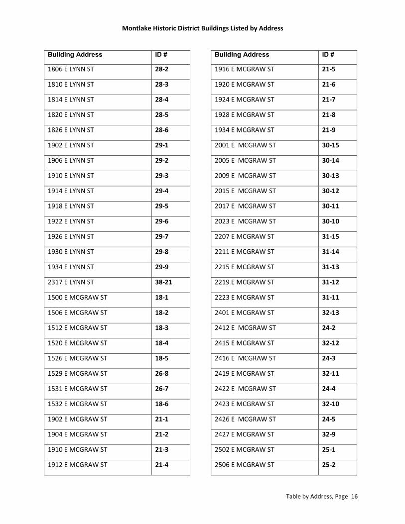
Montlake Historic District Buildings Listed by Address
Table by Address, Page 16
Building Address ID #
1806 E LYNN ST 28-2
1810 E LYNN ST 28-3
1814 E LYNN ST 28-4
1820 E LYNN ST 28-5
1826 E LYNN ST 28-6
1902 E LYNN ST 29-1
1906 E LYNN ST 29-2
1910 E LYNN ST 29-3
1914 E LYNN ST 29-4
1918 E LYNN ST 29-5
1922 E LYNN ST 29-6
1926 E LYNN ST 29-7
1930 E LYNN ST 29-8
1934 E LYNN ST 29-9
2317 E LYNN ST 38-21
1500 E MCGRAW ST 18-1
1506 E MCGRAW ST 18-2
1512 E MCGRAW ST 18-3
1520 E MCGRAW ST 18-4
1526 E MCGRAW ST 18-5
1529 E MCGRAW ST 26-8
1531 E MCGRAW ST 26-7
1532 E MCGRAW ST 18-6
1902 E MCGRAW ST 21-1
1904 E MCGRAW ST 21-2
1910 E MCGRAW ST 21-3
1912 E MCGRAW ST 21-4
Building Address ID #
1916 E MCGRAW ST 21-5
1920 E MCGRAW ST 21-6
1924 E MCGRAW ST 21-7
1928 E MCGRAW ST 21-8
1934 E MCGRAW ST 21-9
2001 E MCGRAW ST 30-15
2005 E MCGRAW ST 30-14
2009 E MCGRAW ST 30-13
2015 E MCGRAW ST 30-12
2017 E MCGRAW ST 30-11
2023 E MCGRAW ST 30-10
2207 E MCGRAW ST 31-15
2211 E MCGRAW ST 31-14
2215 E MCGRAW ST 31-13
2219 E MCGRAW ST 31-12
2223 E MCGRAW ST 31-11
2401 E MCGRAW ST 32-13
2412 E MCGRAW ST 24-2
2415 E MCGRAW ST 32-12
2416 E MCGRAW ST 24-3
2419 E MCGRAW ST 32-11
2422 E MCGRAW ST 24-4
2423 E MCGRAW ST 32-10
2426 E MCGRAW ST 24-5
2427 E MCGRAW ST 32-9
2502 E MCGRAW ST 25-1
2506 E MCGRAW ST 25-2

Montlake Historic District Buildings Listed by Address
Table by Address, Page 17
Building Address ID #
2507 E MCGRAW ST 33-16
2509 E MCGRAW ST 33-15
2510 E MCGRAW ST 25-3
2514 E MCGRAW ST 25-4
2515 E MCGRAW ST 33-14
2517 E MCGRAW ST 33-13
2518 E MCGRAW ST 25-5
2520 E MCGRAW ST 25-6
2521 E MCGRAW ST 33-12
2525 E MCGRAW ST 33-11
2526 E MCGRAW ST 25-7
2532 E MCGRAW ST 25-8
1602 E MCGRAW ST 19-1
1606 E MCGRAW ST 19-2
1607 E MCGRAW ST 27-16
1611 E MCGRAW ST 27-15
1612 E MCGRAW ST 19-3
1615 E MCGRAW ST 27-14
1616 E MCGRAW ST 19-4
1620 E MCGRAW ST 19-5
1621 E MCGRAW ST 27-13
1624 E MCGRAW ST 19-6
1625 E MCGRAW ST 27-12
1628 E MCGRAW ST 19-7
1632 E MCGRAW ST 19-8
1802 E MCGRAW ST 20-1
1808 E MCGRAW ST 20-2
Building Address ID #
1809 E MCGRAW ST 28-14
1812E MCGRAW ST 20-3
1815 E MCGRAW ST 28-13
1816 E MCGRAW ST 20-4
1820 E MCGRAW ST 20-5
1821 E MCGRAW ST 28-12
1824 E MCGRAW ST 20-6
1827 E MCGRAW ST 28-11
1909 E MCGRAW ST 29-16
1915 E MCGRAW ST 29-15
1919 E MCGRAW ST 29-14
1923 E MCGRAW ST 29-13
1927 E MCGRAW ST 29-12
1931 E MCGRAW ST 29-11
1935 E MCGRAW ST 29-10
2202 E MCGRAW ST 23-1
2208 E MCGRAW ST 23-2
2214 E MCGRAW ST 23-3
2218 E MCGRAW ST 23-4
2222 E MCGRAW ST 23-5
1907 E MILLER ST 13-15
1915 E MILLER ST 13-14
1918 E MILLER ST 5-1
1921 E MILLER ST 13-13
1924 E MILLER ST 5-2
1925 E MILLER ST 13-12
1934 E MILLER ST 5-3

Montlake Historic District Buildings Listed by Address
Table by Address, Page 18
Building Address ID #
2001 E MILLER ST 14-16
2002 E MILLER ST 10-1
2006 E MILLER ST 10-2
2007 E MILLER ST 14-15
2011 E MILLER ST 14-14
2012 E MILLER ST 10-3
2014 E MILLER ST 10-4
2016 E MILLER ST 10-5
2017 E MILLER ST 14-13
2020 E MILLER ST 10-6
2021 E MILLER ST 14-12
2025 E MILLER ST 14-11
2026 E MILLER ST 10-7
2029 E MILLER ST 14-10
2033 E MILLER ST 14-9
2203 E MILLER ST 15-16
2208 E MILLER ST 11-2
2211 E MILLER ST 15-15
2212 E MILLER ST 11-3
2215 E MILLER ST 15-14
2216 E MILLER ST 11-4
2220 E MILLER ST 11-5
2221 E MILLER ST 15-13
2224 E MILLER ST 11-6
2225 E MILLER ST 15-12
2229 E MILLER ST 15-11
2230 E MILLER ST 11-7
Building Address ID #
2233 E MILLER ST 15-10
2408 E MILLER ST 12-2
2409 E MILLER ST 16-14
2411 E MILLER ST 16-13
2412 E MILLER ST 12-3
2417 E MILLER ST 16-12
2418 E MILLER ST 12-4
2420 E MILLER ST 12-5
2423 E MILLER ST 16-11
2426 E MILLER ST 12-6
2427 E MILLER ST 16-10
2428 E MILLER ST 12-7
2433 E MILLER ST 16-9
2434 E MILLER ST 12-8
2507 E MILLER ST 17-13
2508 E MILLER ST 9-2
2509 E MILLER ST 17-12
2512 E MILLER ST 9-3
2517 E MILLER ST 17-11
2518 E MILLER ST 9-4
2521 E MILLER ST 17-10
2524 E MILLER ST 9-5
2530 E MILLER ST 9-6
2723 MONTLAKE BLVD NE 3-12
2723 MONTLAKE BLVD NE 3-13
2734 MONTLAKE BLVD NE 2-2
2740 MONTLAKE BLVD NE 2-3

Montlake Historic District Buildings Listed by Address
Table by Address, Page 19
Building Address ID #
2800 MONTLAKE BLVD NE 2-25
2809 MONTLAKE BLVD NE 1-20
2810 MONTLAKE BLVD NE 2-26
2812 MONTLAKE BLVD NE 2-27
2815 MONTLAKE BLVD NE 1-21
2818 MONTLAKE BLVD NE 2-28
2904 MONTLAKE BLVD NE 2-50
2907 MONTLAKE BLVD NE 1-60
2908 MONTLAKE BLVD NE 2-51
2462 W MONTLAKE PL E 13-16
2501 W MONTLAKE PL E 5-10
2507 W MONTLAKE PL E 5-11
2510 W MONTLAKE PL E 5-8
2511 W MONTLAKE PL E 5-12
2517 W MONTLAKE PL E 5-13
2520 W MONTLAKE PL E 5-9
2521 W MONTLAKE PL E 5-14
2553 W MONTLAKE PL E 5-15
2563 W MONTLAKE PL E 5-16
2564 W MONTLAKE PL E 6-12
2571 W MONTLAKE PL E 5-17
2575 W MONTLAKE PL E 5-18
2625 E MONTLAKE PL E 6-14
2571 E MONTLAKE PL E 7-7
2600 E MONTLAKE PL E 4-55
2604 E MONTLAKE PL E 4-54
2610 E MONTLAKE PL E 4-53
Building Address ID #
2616 E MONTLAKE PL E 4-52
2015 E NEWTON ST 36-12
2018 E NEWTON ST 37-1
2019 E NEWTON ST 36-11
2020 E NEWTON ST 37-2
2021 E NEWTON ST 36-10
2025 E NEWTON ST 36-9
2029 E NEWTON ST 36-8
2032 E NEWTON ST 37-3
2033 E NEWTON ST 36-7
2035 E NEWTON ST 36-6
2045 E NEWTON ST 36-5
2049 E NEWTON ST 36-4
2201 E NEWTON ST 44-20
2205 E NEWTON ST 44-19
2211 E NEWTON ST 44-18
2217 E NEWTON ST 44-17
2220 E NEWTON ST 37-24
2221 E NEWTON ST 44-16
2225 E NEWTON ST 44-15
2402 E NEWTON ST 39-1
2415 E NEWTON ST 45-20
2304 E NEWTON ST 38-42
2503 E NEWTON ST 46-33
2219 E NORTH ST 4-45
2225 E NORTH ST 4-44
2817 E PARK DR 2-15

Montlake Historic District Buildings Listed by Address
Table by Address, Page 20
Building Address ID #
2810 W PARK DR E 1-41
2814 W PARK DR E 1-40
2009 E ROANOKE ST 6-11
2015 E ROANOKE ST 6-10
2023E ROANOKE ST 6-9
2201 E ROANOKE ST 7-10
2205 E ROANOKE ST 7-9
2209 E ROANOKE ST 7-8
2251 E ROANOKE ST 8-21
2403 E ROANOKE ST 8-16
2409 E ROANOKE ST 8-15
2411 E ROANOKE ST 8-14
2415 E ROANOKE ST 8-13
2421 E ROANOKE ST 8-12
2425 E ROANOKE ST 8-11
2429 E ROANOKE ST 8-10
2505 E ROANOKE ST 9-26
2515 E ROANOKE ST 9-25
2555 E ROANOKE ST 9-14
2559 E ROANOKE ST 9-13
2212 E ROANOKE ST 4-1
2216 E ROANOKE ST 4-2
2220 E ROANOKE ST 4-3
2400 E ROANOKE ST 4-4
2404 E ROANOKE ST 4-5
2408 E ROANOKE ST 4-6
2412 E ROANOKE ST 4-7
Building Address ID #
2422 E ROANOKE ST 4-11
2428 E ROANOKE ST 4-12
2432 E ROANOKE ST 4-13
2436 E ROANOKE ST 4-14
2502 E ROANOKE ST 4-18
2512 E ROANOKE ST 4-19
2552 E ROANOKE ST 4-22
2556 E ROANOKE ST 4-23
2603 E ROANOKE ST 4-24
2518 ROYAL CT E 4-20
2519 ROYAL CT E 4-21
2523 ROYAL CT E 9-19
2524 ROYAL CT E 9-20
2527 ROYAL CT E 9-21
2528 ROYAL CT E 9-18
2531 ROYAL CT E 9-22
2532 ROYAL CT E 9-17
2535 ROYAL CT E 9-23
2536 ROYAL CT E 9-16
2607 ROYAL CT E 9-24
2611 ROYAL CT E 9-15
1800 E SHELBY ST 1-42
1803 E SHELBY ST 1-39
1811 E SHELBY ST 1-38
1812 E SHELBY ST 1-43
1817 E SHELBY ST 1-37
1818 E SHELBY ST 1-44

Montlake Historic District Buildings Listed by Address
Table by Address, Page 21
Building Address ID #
1822 E SHELBY ST 1-45
1823 E SHELBY ST 1-36
1826 E SHELBY ST 1-46
1827 E SHELBY ST 1-35
1832 E SHELBY ST 1-47
1833 E SHELBY ST 1-34
1837 E SHELBY ST 1-33
1838 E SHELBY ST 1-48
1840 E SHELBY ST 1-49
1843 E SHELBY ST 1-32
1846 E SHELBY ST 1-50
1847 E SHELBY ST 1-31
1851 E SHELBY ST 1-30
1852 E SHELBY ST 1-51
1855 E SHELBY ST 1-29
1856 E SHELBY ST 1-52
1862 E SHELBY ST 1-53
1863 E SHELBY ST 1-28
1866 E SHELBY ST 1-54
1869 E SHELBY ST 1-27
1873 E SHELBY ST 1-26
1874 E SHELBY ST 1-55
1876 E SHELBY ST 1-56
1877 E SHELBY ST 1-25
1882 E SHELBY ST 1-57
1883 E SHELBY ST 1-24
1886 E SHELBY ST 1-58
Building Address ID #
1887 E SHELBY ST 1-23
1894 E SHELBY ST 1-59
1897 E SHELBY ST 1-22
2111 E SHELBY ST 2-29
2112 E SHELBY ST 2-49
2117 E SHELBY ST 2-30
2118 E SHELBY ST 2-48
2121 E SHELBY ST 2-31
2122 E SHELBY ST 2-47
2126 E SHELBY ST 2-46
2127 E SHELBY ST 2-32
2132 E SHELBY ST 2-45
2133 E SHELBY ST 2-33
2136 E SHELBY ST 2-44
2137 E SHELBY ST 2-34
2142 E SHELBY ST 2-43
2143 E SHELBY ST 2-35
2146 E SHELBY ST 2-42
2147 E SHELBY ST 2-36
2152 E SHELBY ST 2-41
2153 E SHELBY ST 2-37
2158 E SHELBY ST 2-40
2159 E SHELBY ST 2-38
2159 E SHELBY ST 3-14
2159 E SHELBY ST 3-15
2159 E SHELBY ST 3-16