National Physical Planning Policy -
104
1 National Physical Planning Policy and Plan Sri Lanka -2030 National Physical Planning Department 20 th April 2010
Transcript of National Physical Planning Policy -

1
National Physical Planning Policy and Plan
Sri Lanka -2030
National Physical Planning Department 20
th April 2010

2
National Physical Planning Policy and Plan
Sri Lanka -2030
National Physical Planning Department
(NPPD) 5th Floor Sethsiripaya
Battaramulla Sri Lanka
Telephone: (011) 2872046Fax: (011)2872061
E-mail: [email protected]
20th April 2010

3
INTRODUCTION
The National Physical Planning Policy and was prepared in terms of the provisions of the
Town and Country Planning Ordinance No.13 of 1946 as amended by Act No.49 of 2000.
The plan was forwarded to the Technical Advisory Committee and the Inter-Ministerial
Coordinating Committee as per sections 5C and 4A of the Act and was approved by the
National Physical Planning Council as per section 4(a) of the Act on the 3rd of June 2007.
This document which is an expansion of the above outlines the National Physical
Planning Policy and Plan and is published with the following specific objectives:
1. As a guide to government agencies for future planning of their programmes;
2. As a guide to private sector for investment opportunities either on its own or
private-public sector partnership basis;
3. As a guide to policy makers;
4. As an informative document to the general public.
5. Listing of large scale infrastructure /township projects available for investment.

4
Contents
Section 1: National Physical Planning Policy and Plan 5
Background 5
Purpose 6
Guiding principles 8
Components of the National Physical Plan and Policy 8
Section 2: Vision and Objectives 10
National Vision 10
National Objectives 11
Section 3: National and International Context 12
Section 4: Key Elements 20
Section 5: Principles and Strategies: 23
1. Protecting the environment 23 2. Reducing vulnerability to natural disasters 33 3. Human settlement development 35 4. Infrastructure facilities 41 5. Water resource development 49 6. Economic development 54 Spatial Structure Plan 65
Section 6: Implementation 67
1. Preparation, Gazetting and Implementation of regional and local plans
2. Coordination of Government Policy
3. Projects
4. Northern Province Regional Structure Plan
5. North Central Metropolis
6. Eastern Province Structure Plan
7. Sabaragamuwa Province Structure Plan
8. Airport Expansion
9. Asian Highway
10. Conservation Strategy

5
Maps and Figures Map 1: Sri Lanka in the global context Map 2: Sri Lanka‘s Exclusive Economic Zone Map 3: Regional offshore petroleum resources Map 4: The global optical fibre submarine system Map 5: Regional Sea routes Map 6: Global air routes Map 7: Proposed link to the Asian Highway Map 8: Proposed Trans-Asian Railway Network Map 9: Fragile Areas Map 10: Categorized settlements in the Central Fragile Area Map 11: Protected Area Network Map 12: Existing settlement pattern Map 13: Settlement pattern 2030 and schematic location of Metro Regions Map 14: Existing and proposed rail Map 15: Existing roads Map 16: Proposed roads Map 17: Existing and proposed ports Map 18: Existing and proposed airports Map 19: Highly productive agricultural areas Map 20: Existing and proposed industrial estates Map 21: Areas reserved for mineral exploration Map 22: Tourist development areas Map 23: Potential Ecotourism development areas Map 24: Existing and proposed fishery harbours Map 25: Spatial structure plan Figure 1: National Physical Plan making process Figure 2: Components of the National Physical Planning Policy
and National Physical Plan Figure 3: Projected population for Metro Cities and District Capitals Figure 4: Regional plan implementation process Figure 5: Implementation process for the strategies of the National Physical Plan Figure 6: Project implementation procedure
Appendices Appendix A: Categorized settlements in the Central Fragile Area
Background papers The National Physical Planning Policy and National Physical Plan together form the key document that promotes and regulates integrated planning of physical, environmental economic and social aspects of land in Sri Lanka. During the preparation a number of research reports were prepared. These reports are the background documents that support the National Physical Planning Policy and Plan and are as follows:
National Physical Planning Policy Volume I: Policies, September 2002; National Physical Planning Policy Volume II: Detailed policy report, September
2002;

6
National Physical Planning Policy Volume III: Defining spatial units for implementing the National Physical Planning Policy, September 2002;
National Physical Planning Policy Volume IV: Resource base for the preparation of the National Physical Planning Policies, September 2002;
Protected Area Network: Areas identified for protecting under different categories, November 2005;
Fragile Area: Proposed Conservation Strategy, May 2005; Policies prepared by sectoral agencies that are relevant to the National Physical
Plan, November 2006;
Physical Planning Guidelines and Project Proposals for the ‗Vulnerable‘ Coastal Zone of Sri Lanka, January 2005;
Coastal Management Plan, 2004.

7
Section 1:
Introduction
Background In 1997 the Presidential Task Force on Housing and Urban Development recommended that there should be a National Spatial Plan for Sri Lanka. The National Physical Planning Department was set up under the Town and Country Planning (Amendment) Act No. 49 of 2000 to prepare and implement the National Physical Plan. The preparation of both the National Physical Planning Policy and the National Physical Plan have been guided by an advisory council of professionals and approved by two committees, established under the Town and Country Planning (Amendment) Act, as follows:
the Technical Advisory Committee (TAC) includes representatives from the Professional Institutions such as the Engineers Institute, Architects Institute, Surveyors Institute, Town Planners Institute and the National Planning Department and Finance Ministry;
the Inter-Ministerial Secretaries Co-ordinating Committee (IMCC) consisting of Secretaries of each Ministry as identified in the Act and Chief Secretaries of the nine Provincial Councils. This committee coordinates with those involved in the implementation of any plans and projects recommended by the National Physical Planning Council; and
the National Physical Planning Council (NPPC) headed by H.E the President and consisting of Hon. Ministers as identified in the Act as well as the Chief Ministers nine Provincial Councils. Important issues relevant to the development and implementation of the National Physical Planning Policy are brought before the council to be resolved.
Preparing the National Physical Planning Policy and Plan The National Physical Planning Policy, National Physical Plan, and its background studies were prepared with input from many government departments and agencies, non-government agencies and research undertaken by the National Physical Planning Department. It is a result of dialogue with a range of stakeholders, experts and government officials. With this input, the National Physical Planning Policy and National Physical Plan will provide a single voice for government in the physical planning and development of Sri Lanka. Gazetting the Policy and Plan will make it the pre-eminent document for plan making and implementation of the identified projects. The Town and Country Planning Amendment Act No. 49 of 2000 outlines the process that must be undertaken when preparing the National Physical Plan.

8
Figure 1: National Physical Plan approval process
Purpose
The National Physical Planning Policy and National Physical Plan provide a broad framework to secure Sri Lanka‘s place in the global economy by promoting economic growth. It is a strategic document that outlines a vision for Sri Lanka to 2030. Its role is to promote and regulate the integrated planning of economic, social, physical and environment aspects of land in Sri Lanka. Another important function of the National Physical Plan is to bring the Government, stakeholders and the community together to discuss, review and then make decisions to guide the future of Sri Lanka‘s economy, environment and communities. Sri Lanka is fortunate to have significant untapped economic resources, a unique natural environment and important fragile areas. Untapped resources include minerals and fish within Sri Lanka‘s Exclusive Economic Zone. The unique natural environment supports a wide range of ecosystems with exceptional biodiversity, and provides an opportunity to improve tourism, including ecotourism, which enhances and protects that natural environment. Fragile areas of Sri Lanka include the coastal zone, hill country and network of national parks, and flora and fauna habitats and corridors. Preservation of the fragile areas and the natural environment is important for the sustainable development of the country.
National Physical Planning Council
Inter - Ministerial Coordination Committee
National Physical
Planning Policy
Technical
Advisory
Committee
Planning
Agencies
(Urban
Development
Authority,
Local
Authorities)
Infrastructure
Agencies
Plan making process
National Physical Planning Council
Inter - Ministerial Coordination Committee
Committee
National Physical
Planning Policy
Technical
Advisory
Committee
Planning
Agencies
(Urban
Development
Authority,
Local
Authorities)
Infrastructure
Agencies
Investors Private Sector Public Sector Donor
Projects

9
Constraining these identified opportunities are some factors which may reduce Sri Lanka‘s ability to build on domestic competitive advantages. The lack of reliable sources of electricity and water, and poor access to efficient transport, social infrastructure and employment opportunities, have contributed to the widening regional disparity in terms of education, quality of life and income across Sri Lanka. The civil conflict has displaced many people, resulting in ethnic and social imbalances, and contributing to existing issues of poverty, low per capita income and regional disparity. The difficulty in moving people and goods around the country, as a result of rundown transport infrastructure, is a key issue constraining equitable economic growth across Sri Lanka, and international investment. Sri Lanka‘s strategic geographical location in relation to import and export markets, major regional infrastructure and transportation could provide an edge over many other countries in terms of economic development. There are many opportunities available for Sri Lanka to take advantage of its strategic location, and play a greater role in the South Asian Region and global economy, including: the provision of air and sea hub facilities which build on proximity to international
sea routes and major regional aviation destinations;
developing road and rail connections with the South Asian mainland to link Sri Lanka with the Asian Highway and Trans Asian Railway;
improving Sri Lanka‘s telecommunication industry by linking into the global optical fibre submarine system; and
extraction of offshore petroleum resources and associated development of a petrochemical sector.
The end of the civil conflict in Sri Lanka would most likely also see a return to the high volume of tourist demand for the coastal, central and northern areas of Sri Lanka and increase demands for domestic and regional air travel infrastructure. Factors constraining international opportunities include global warming, and linkages to the international economy. Climate change has emerged as a key concern for Sri Lanka and its people in the 21st century. Sea level rise, warming temperatures, uncertain effects on forest and agricultural systems, and increased variability and volatility in weather patterns are expected to have a significant impact in the developing world, where people remain most susceptible to the potential damages and uncertainties inherent in a changing climate. The existing domestic and international transport networks are unable to sufficiently facilitate the international movement of people for both tourist and business purposes. The lack of road, rail and telecommunication corridors across the Palk Straight may constrain growth in the future.
The purpose of the National Physical Planning Policy and Plan is to provide an integrated land use and infrastructure framework that will enable Sri Lanka to make best use of its natural resources and strategic location in the South Asia Region.
Vision
Objectives
Key Elements
Principles
Strategies
Projects
National Physical Plan
Section 2
Section 3
Section 5
Section 6
National Physical Planning Policy
Vision
Objectives
Key Elements
Principles
Strategies
Projects
National Physical Plan
Section 2
Section 3
Section 5
Section 6
Vision
Objectives
Key Elements
Principles
Strategies
Projects
National Physical Plan
Section 2
Section 3
Section 5
Section 6
National Physical Planning Policy

10
Guiding principles Economic, social and environmental sustainability are the guiding principles for the National Physical Planning Policy and National Physical Plan. Sustainable development requires the effective integration of economic, social and environmental considerations in decision-making processes, and can be achieved through the implementation of the following principles:
the precautionary principle - if there are threats of serious or irreversible environmental damage, lack of full scientific certainty should not be used as a reason for postponing measures to prevent environmental degradation;
inter-generational equity - the present generation should ensure that the health, diversity and productivity of the environment are maintained or enhanced for the benefit of future generations;
conservation of biological diversity; and ecological integrity - conservation of biological diversity and ecological integrity should be a fundamental consideration; and
improved valuation, pricing and incentive mechanisms - environmental factors should be included in the valuation of assets and services.
The principles of sustainable development provide a framework for addressing the issues and challenges that will face Sri Lanka towards 2030. Resolution of competing or conflicting proposals, and prioritising projects, can be facilitated by adherence to these long term and globally oriented guiding principles. Environmental protection and social integration, for instance, are core components of continued economic growth and development. Progress towards the stated vision and objectives is unlikely to be balanced and equitable if the principles of sustainable development are not fully integrated into the development and implementation of physical planning at the national, regional and local levels.
Components This document contains both the National Physical Planning Policy and the National Physical Plan. The National Physical Planning Policy sets out the strategic direction for the growth and development of Sri Lanka. Figure 2 outlines that the National Physical Planning Policy includes all components of the document. The National Physical Plan provides a spatial context to the National Physical Planning Policy and identifies the strategies and projects for implementing the principles of the National Planning Policy. Importantly, the National Physical Plan also sets out a process for implementing national level projects and provides guidance for the preparation of regional, district and local plans. Figure 1 also provides the structure of this document

11
Figure 2: Components of the National Physical Planning Policy and National Physical Plan
Conclusion The National Physical Planning Policy and Plan sets out the framework for the future development of Sri Lanka. It was prepared using the principles of economic social and environmental sustainability. This is reflected in the Vision for Sri Lanka in 2030 and the Objectives that support the Vision.
Vision
Objectives
Key Elements
Principles
Strategies
Projects
National Physical Plan
Section 2
Section 3
Section 5
Section 6
National Physical Planning Policy
Vision
Objectives
Key Elements
Principles
Strategies
Projects
National Physical Plan
Section 2
Section 3
Section 5
Section 6
Vision
Objectives
Key Elements
Principles
Strategies
Projects
National Physical Plan
Section 2
Section 3
Section 5
Section 6
National Physical Planning Policy

12
Section 2:
Vision and Objectives The Vision defines the long term aspiration of the Country. It considers Sri Lanka‘s international context and describes the environment that Sri Lanka would like to live in the future. The Objectives provide the tools to achieve the Vision and set the framework for the Principles and Strategies of the National Physical Planning Policy and Plan.
Vision By 2030 Sri Lanka will have a sustainable pattern of development made up of a network of cities, towns and villages connected by an efficient infrastructure network. The settlement pattern and supporting infrastructure network will facilitate economic growth and contribute to reducing social and economic disparities between the regions. Cities, towns and villages will retain their own character, identity and economic base and provide a range of services appropriate to their size and function. They will be good places to live and provide for the needs of a diverse community through the provision of social, recreation, education and community facilities. An important function of cites, towns and villages will be to provide appropriate services to their surrounding rural hinterland. There will be a balance between conservation, development and economic production. Land that has important environmental or cultural values will be retained and protected, providing important recreation and economic assets to the county. The main focus of this Vision will be a future for Sri Lanka that is sustainable where:
important environmental assets are protected; the fragile areas are protected from inappropriate development and is used
for conservation, recreation, tourism and appropriate economic activities; there is minimal threat of natural disasters on human settlements and
supporting infrastructure;
a network of cities, towns and villages provide a range of employment opportunities, services and a high quality of life;
regions with strong development potential interact together to provide the basis for a diverse economy;
the rural areas are protected from haphazard urban expansion; a network of infrastructure will support the settlement pattern and economic
activities; a transport system will support the settlement pattern and improve the
mobility of people and products; international and domestic air and sea transport facilities and services
strengthen Sri Lanka‘s locational advantage;

13
maximum use is made of offshore resources including the exploitation of fish, mineral petroleum, energy and other oceanic assets;
there is community integration, peace and prosperity for all communities.
Objectives To achieve the vision, the National Physical Planning Policy is expected to:
1. Protect the environment through limiting development in fragile areas, the Protected Area Network and areas of local and regional environmental significance;
2. Ensure that the people of Sri Lanka live in areas that are safe from natural disasters and effects of global warming including rising sea level;
3. Create a strong network of cities towns and villages that provide a high quality of life, an appropriate range of services, diverse employment opportunities and community integration;
4. Provide infrastructure facilities that will support cities, towns and villages and economic activities;
5. Protect water catchments and water resources to improve water quality and ensure sufficient supply of water for domestic, agricultural, industrial activities and power generation;
6. Provide an integrated spatial pattern of development that finds the balance between production and protection of natural resources and encourages economic development.
Conclusion The Vision sets out the aspirations for the future, while the Objectives set out how the Vision will be achieved. To implement the Objectives, each objective has a number of Principles and Strategies that are discussed in Section 5.

14
Section 3:
National and International Context The past few decades have seen major shifts in both the Sri Lankan and South Asian economies. Whereas in the mid-twentieth century the Sri Lankan economy was largely based around production of tea, rubber and coconut, in more recent times a combination of the remittances from Sri Lankans working abroad, the local apparel industry, and the export of tea are the major economic sectors and foreign exchange earners. Other important sectors include export of precious and semi-precious stones, and earnings from tourism, although this has reduced due to the tsunami that occurred in December 2004 but is showing signs of a fast recovery and further growth in the aftermath of the cessation of the protracted war. These shifts in economic activities reflect changes of global trends towards high productivity commodity production and of services with a higher return such as telecommunications. Sri Lanka, which has a population of 18 million constitutes the 51st most populous nation, and in terms of population density Sri Lanka occupies the 36th position in the world (12th in Asia). New urban centres across the South Asian region are developing as a result of population growth and migration, local resources and a competitive advantage in the availability of skills. The international demand for low cost, high-quality service industries (such as call centres) are being exploited by urban centres across countries such as India, Pakistan and Singapore, which are able to benefit from developed infrastructure, high levels of education, English language skills, entrepreneurship and pro-active national and local governments. Map 1: Sri Lanka in the global context
Source: http://geography.about.com/library/cia/blcindian.htm
15
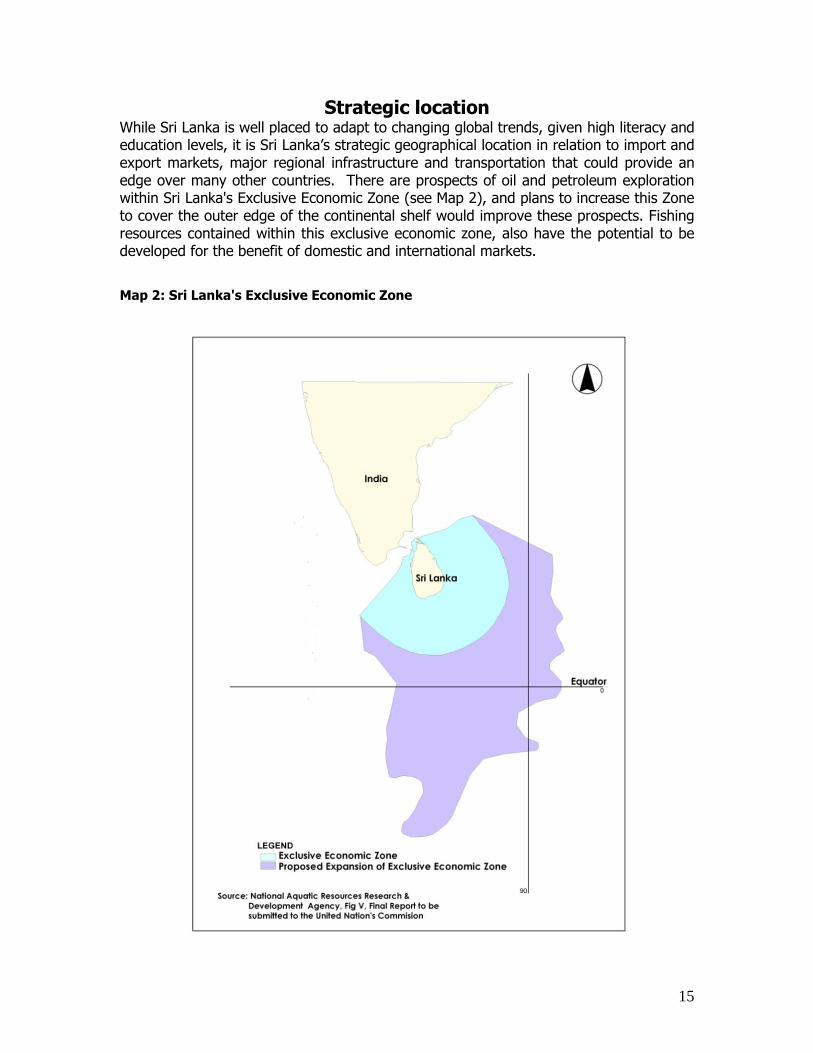
Strategic location While Sri Lanka is well placed to adapt to changing global trends, given high literacy and education levels, it is Sri Lanka‘s strategic geographical location in relation to import and export markets, major regional infrastructure and transportation that could provide an edge over many other countries. There are prospects of oil and petroleum exploration within Sri Lanka's Exclusive Economic Zone (see Map 2), and plans to increase this Zone to cover the outer edge of the continental shelf would improve these prospects. Fishing resources contained within this exclusive economic zone, also have the potential to be developed for the benefit of domestic and international markets.
Map 2: Sri Lanka's Exclusive Economic Zone

16
Map 3: Regional offshore petroleum resources
Further, Sri Lanka forms a critical hub in the optical fibre submarine network (see Map 4), and Sri Lanka‘s southwest coast is approximately 4 miles from the major international east-west shipping routes (see Map 5), transporting oil and containers between the Middle East and Singapore and other countries.
Map 4: The global optical fibre submarine system

17
Transport and Access One factor that directly affects the economy and economic growth is the effectiveness of the transport network. Transport is influential at the local, national, regional and international level, with strong networks and linkages being often essential elements of successful and high growth economies. Being an island nation, Sri Lanka‘s linkages with other countries are currently only possible by sea and air.
Map 5: Regional Sea routes
#
#
#
#
#
#
##
##
#
#
# ##
##
###
#
##
# ### #
##
# ## #
#
##
#
# ###
## #
##
# ##
## # ##
##
###
#
#
##
##
##
###
##
##
###
#
#
#
# #
##
#
##
### #
#
#
###
#
#
#
##
#
#
#
#
#
#
#
##
#
#
#
#
#
#
#
##
#
#
#
#
#
#
#
#
#
#
#
#
#
#
#
#
#
#
#
#
#
#
#
#
#
#
#
#
#
#
#
#
#
#
#
#
#
#
#
#
#
#
#
#
#
#
#
#
#
#
#
#
#
#
#
#
#
#
#
#
#
#
#
#
#
#
#
#
#
#
#
#
#
#
#
#
#
#
#
#
#
#
#
#
#
#
#
#
#
#
##
#
Kazakhstan
Uzbekistan
Turkmenistan
Iran Afghanistan
Pakistan
Tajikistan
Kyrgyzstan
China
Bhutan
Bangladesh
Myanmar (Burma)Vietnam
Laos
Thailand
Malaysia
Cambodia
Vietnam
Saudi Arabia
Iraq
Syria
Turkey
CyprusLebanon
Egypt
Israel
Jordan
Yemen
Oman
United Arab Emirates
Kuwait
India
Sri Lanka
Indonesia
Philippines
Taiwan
Singapore
Madagascar
British Indian Ocean Territory
Seychelles
Maldives
Somalia
Ethiopia
Kenya
Tanzania, United Republic of
Mozambique
Nepal
Oman
Japan
South Korea
Urumqi
Islamabad
AmritsarFaisalabad
New DelhiJaipur
Ahmadabad
Hyderabad
Nagpur
PatnaBenares
Lucknow
Bangalore
Madurai
Colombo
Mangalore
Pune
Hyderabad
Lahore
Aden
Shiraz
Yazd
Tehran
Baghdad
Samarkand
Mashhad
Ashkhabad
Mecca
Al Madinah
Ar Riyad
Jiddah
Al Kuwayt
Al Basra
Karachi
Singapore
George Town
Kuala Lumpur
Jakarta
BandungSurabaja
Vjuag Padang
Manado
Davao
Manila
T`ai-chungTaipei
Hue
HaiphongHanoi
Rangoon
Mandalay
KathmanduThimbu
Hong Kong
Guangzhou
Shanghai
Beijing
Lhasa
Lanzhou
Chengdu
Bangkok
Vientiane
Phnom PenhHo Chi Minh City
Toamasina
Antananarivo
Vishakhapatnam
Cochin
Mumbai
Sanaa
Adis Abeba
Muqdisho
Nairobi
Mombasa
Dar es Salaam
Mtwara
Dodoma
Russia
Mongolia
Source: National Physical Planning Department
The advantages of linking Sri Lanka by air to one or more of the South Asian regional air hubs (such as Delhi, Chennai, Kolkata and Mumbai), and international hubs (such as Singapore, Bangkok and Hong Kong) include improving access to cargo and freight transport, in addition to facilitating business and tourist passenger travel. Expanding the capacity of Sri Lankan domestic airports to enable both improved domestic and regional linkages would also contribute to improved connectivity. Existing patterns of tourism travel are likely to be influenced by improved access to Sri Lanka, particularly if a second international airport and improved domestic air travel facilities are developed. The end of the conflict in Sri Lanka already indicates a return to the high volume of tourist demand for the coastal, central and northern areas of Sri Lanka which increase demands for domestic and regional air travel infrastructure.

18
Map 6 Global air routes
Proposals to link Sri Lanka with the South Asian mainland by road and rail, such as the Asian Highway (Map 6) and Trans-Asian Railway (Map 7) would drastically change Sri Lanka‘s trade and exchange with India and other South Asian neighbours.
Map 7 Proposed link to the Asian Highway

19
Map 8 Proposed Trans- Asian Railway Network
Emerging Regionalism Sri Lanka forms part of the South Asian Association for Regional Cooperation (SAARC), which is the largest regional organisation in the world, covering approximately 1.47 billion people. SAARC is an economic and political organisation of eight countries in Southern Asia, including India, Pakistan, Bangladesh, Sri Lanka, Nepal, Afghanistan, Maldives and Bhutan. Other regional links are formalised through organisations such as the Indian Ocean Rim Association for Regional Cooperation (IOR-ARC) and in the Bay of Bengal Initiative for Multi-Sectoral Technical and Economic Cooperation (BIMSTEC). Further, trade agreements with South Asian countries such as India have further enhanced economic ties and created an emerging sense of regionalism in South Asia.
To take advantage of this emerging regionalism, and ensure that Sri Lanka is a lead country within the South Asian regional context, it is critical that the linkages between this island nation and the continent are reinforced by facilitating infrastructure. This may include:
establishing Sri Lanka‘s role as a hub within the regional and global hierarchy of sea ports;

20
creating sufficient domestic and international airport network to facilitate the movement of people for both tourist and business purposes, and create a regional hub for cargo and passenger transport;
developing road, rail and telecommunication corridors across the Palk Straight; introduce new urban centres with a strong service base to match international
demand; ensuring that Colombo continues to perform its role as an influential regional
economic centre; and
affording employment and education, health, recreation, sporting and entertainment opportunities to meet both domestic and international demand.
The many opportunities available for Sri Lanka to take a greater role in the South Asian Region and global economy include:
potential petroleum resources and development of a petrochemical sector; mineral excavation and processing; expansion of the fishing and fish processing industries; the provision of air and sea transport facilities and develop the services associated
with construction, repair and support for air and sea travel;
increase tourism, including ecotourism that promotes and protects Sri Lanka‘s unique natural environment;
developing Sri Lanka as a trade, finance and industrial hub; first choice provider of specialist skills to the South Asian Region;
improving Sri Lanka‘s telecommunication industry by linking into the global optical fibre submarine system;
fostering an environment that looks outward and attracts investment from both international and national sources.
In effect, increasing globalisation and the rapid growth of the South Asian Region (SAR) have increased regional and international demand for Sri Lankan goods and services, skilled and semi-skilled workers and high quality infrastructure services. Sri Lanka is poised to benefit from the opening up of regional markets through closer economic ties to South Asia. Continued high labour and environment protection standards, high workforce literacy and investment promoting policy atmosphere, are key factors in creating an enabling environment for economic development, both domestically and regionally. However as pointed out ealier it should be noted that factors such as the lack of reliable sources of electricity and water, and poor access to efficient transport, social infrastructure and employment opportunities, have contributed to the widening regional disparity in terms of education, quality of life and income across Sri Lanka. The difficulty in moving people and goods around the country is a key issue constraining equitable economic growth across Sri Lanka.
One direct consequence of these factors is the unwillingness of public and private sectors to relocate away from Colombo, Sri Lanka‘s Global city, and the Western Province. Resulting community and social imbalances need to be addressed and

21
resolved as a priority, if meaningful achievements are to be realised in the global context. The vision, objectives, principles and strategies developed as part of the National Physical Policy and Plan seek to achieve community integration through a national settlement structure, and closer connections to the regional and international economies through improved infrastructure linkages at the domestic level.

22
Section 4:
Key Elements The guiding principle of the National Physical Planning Policy is sustainable development, to enable all Sri Lankans to have a high quality of life. The National Physical Planning Policy provides a framework for sustainable growth. The key elements of the National Physical Planning Policy are as follows.
1. Establishing Sri Lanka’s global position Sri Lanka's strategic location in relation to major international growth centres, regional transport and communication routes, and proximity to the Middle East and South East Asia provides an opportunity for leadership and influence both regionally and internationally. The establishment of international and South Asian regionally focussed roads, sea, air and telecommunication networks, reinforced by improvements in domestic infrastructure will create the conditions for Sri Lanka to engage with trade and political partners to advance domestic interests and promote Sri Lanka‘s place within the global context.
2. Outward development policies Prior to the internal conflict and during periods of extended peace, Sri Lanka has been an attractive destination for foreign investment and tourism. The high levels of workforce literacy and education, developing regional and international passenger and cargo transport, and improving local road, rail and communications infrastructure, provide an attractive scenario for overseas investors if political stability can prevail. An attitude of being ‗open for business‘ pervades the National Physical Planning Policy, which seek to encourage the expansion of local business and the introduction of new overseas business opportunities. Now that peaceful conditions are prevailing, the conditions are ripe for this policy.
3. Creating a sustainable future A key outcome of the National Physical Planning Policy and National Physical Plan is to ensure future growth and development occurs in the most environmentally, economically and socially sustainable way possible. This includes protecting fragile environments, containing urban development, building and maintaining social integration, making travel more efficient, and supporting a strong economy.
4. Integrated communities Improved transport connections, provision of social infrastructure such as schools, hospitals and community facilities, and increased job opportunities in the proposed Metro Cities are all outcomes of the National Physical Planning Policy. Engaging communities through consultation and partnerships will contribute to better outcomes for Government and better community integration. Socio-economic integration of communities, including the reduction of poverty, equal opportunities for diverse ethnic and religious communities, and minimising spatial imbalances in infrastructure investment, will be considered at all times in the development and implementation of policies, plans and projects.

23
5. A new network of compact settlements
Urban settlements will be planned to have a population density that will support a range of services appropriate to its size and function. A compact urban form contributes to sustainable development and enables the appropriate infrastructure to be provided in a more
effective and cost efficient manner. It also protects land from urban sprawl and haphazard
development, providing more land for other uses. Compact urban settlements enable cities,
towns and villages to be the hub of the community and provide a range of social, educational
and community infrastructure. The provision of social services in cities, towns and villages makes best use of investment and provides a focus for community life. The network of settlements will support a settlement hierarchy that includes Metro Regions, Metro Cities, District Capitals, towns and villages.
6. Protecting fragile areas and encouraging alternative uses The Central and Coastal Fragile Areas are important social, economic and environmental resources that require careful management. Current land uses that degrade the sensitive environment will be replaced. The Central Fragile Area is the core of the country, rich in biodiversity and the source of the nation‘s water supply. The conservation of the water catchments in the Central Fragile Area is essential for the economic growth of the nation as well as a sustainable future. Similarly, the Coastal Fragile Area is an important environmental, economic and recreation asset. It also provides a natural buffer that will protect the people of Sri Lanka from the effects of coastal erosion, tsunamis and sea level rises as a result of global warming.
7. Reducing vulnerability to natural disasters Settlements, infrastructure, and economic activity will be located in areas with minimal risk from natural disasters including landslides, floods, earth quakes, tsunamis, cyclones, coastal erosion and the effects of global warming. The settlement pattern will ensure that fewer people, homes and livelihoods are vulnerable to natural disasters. This will provide a safe environment and enable settlements to better cope with environmental challenges in the future.
8. Strong Metro Regions Metro Regions will include an interconnected network of Metro Cities, towns and villages surrounded by rural areas and open space. Each urban settlement will have their unique identity, character and role. Each urban settlement will complement other settlements in the Metro Region to provide a range of employment, educational, commercial, community and recreational opportunities. Together they will provide a range of higher order services, similar to those found in Colombo, to the surrounding areas. The Western Metro Region includes Colombo as a Metro City supported by the District Cities of Gampaha and Kalutra, The Metro Cities of Anuradhapura, Dambulla, Polonnaruwa and Trincomalee will work together to form the North Central Metro Region. Together these Metro Cities will provide the population needed to provide a range of higher order services and act as a counter magnet to Colombo. Batticaloa and Ampara will be the focus of the Eastern Metro Region, whereas Jaffna Metro Region will cover the whole of Jaffna peninsula.
9. Growth of District Capitals
A network of well planned district capitals will have a population of 1 million and provide higher order urban services, amenities and facilities for the needs of their wider hinterlands.
24
They will provide a diverse range of employment opportunities and be the location for the national industrial base. The district capitals will provide a high quality urban environment and be a good place to live. Providing a range of employment, education, commercial, community, social and cultural opportunities will help reduce existing regional disparities and shift the current Colombo focused development towards other parts of the country.
10. Provision of infrastructure and services The settlement pattern provided by the National Physical Plan provides the framework for
the provision of infrastructure and services. Priority will be given to providing infrastructure
and services to Metro Cities and ensuring that urban centres are well serviced by transport
networks, essential services such as water supply and sewerage and telecommunications.
The settlement structure will also provide the focus for the provision of social and
community facilities. The provision of a range of social and community infrastructure in
urban settlements will ensure that these services can be easily accessed by public transport.
11. Integrating land use, transport and economic activity Quality of life and economic development opportunities can be enhanced by easy access to a good transport system. Future land use and transport will be planned and delivered to integrate and focus future activities around transport. Transport infrastructure and service investment across all transport modes will enable more efficient linkages between urban centres, employment areas and areas that link domestic and international activities. The integration of land use, transport and economic activity will ensure that best use is made of Sri Lanka‘s international locational advantage.
12. Reducing Regional Disparities A settlement pattern that integrates urban and rural development though a network of cities
and towns is an important factor in decreasing regional disparities. Metro Cities and Metro
Regions will provide a variety of higher order urban services and employment opportunities.
The availability of a range of employment, educational, community and cultural opportunities
in the regional areas will enable the Metro Cities to act as alternatives to Colombo. This
approach enables more people, including those living in the rural areas, to access a range of
urban services and opportunities. A strong settlement pattern also provides a focus for
infrastructure provision and investment in the regional areas of the country.

25
Section 5:
Principles and Strategies
Introduction The Principles and Strategies provide the tools to achieve the Vision of the National Physical Planning Policy and Plan. The Principles and Strategies guide government‘s planning process and decision making. In addition Regional, Local Plans must be consistent with the Principles and Strategies of the national Physical Planning Policy and Plan. The Principles and Strategies are an integrated holistic set, with no intended priority. They are organised using the Objectives under following headings: 1. protecting the environment; 2. reducing vulnerability to natural disasters; 3. human settlement development; 4. infrastructure facilities; 5. water development; and 6. economic development. The Principles and Strategies for each Objective are summarised by the Spatial Structure Plan.
1. Protecting the environment
Objective 1 Protect the environment through limiting development in fragile areas, the Protected Area Network and areas of local and regional areas of environmental significance.
Context Sri Lanka has a unique natural environment that supports a wide range of ecosystems with exceptional biodiversity. Preservation of the natural environment is not only important for the sustainable development of the country, but also for global biodiversity. The purpose of preserving the natural environment is to ensure the protection of: watershed areas; areas with rare and unique ecosystems of exceptional diversity;
areas with concentrations of threatened species; important aesthetic, cultural, historic and recreational areas; and fragile areas that may easily be degraded.

26
To protect the important features of the environment, the National Physical Plan identifies a: Central Fragile Area; Coastal Fragile Area; and Protected Area Network.
The Central Fragile Area The Central Fragile Area is the heart of the Sri Lanka and comprises almost 14,000 square kilometres of hill country. It is a complex environmental region containing forests and areas of natural beauty that accommodate a large range of biodiversity. It is the headwaters for most major rivers and contributes to the replenishment of the water table. In most instances the areas that are environmentally sensitive and prone to soil erosion coincide with the 300m contour line. As a consequence of the environmental uniqueness and sensitivity, large areas of the Central Fragile Area are unsuitable for development or agricultural production. The steepness of the slopes, high rainfall, and erodibility of the soils combined with inappropriate land uses make this area very susceptible to environmental degradation and landslides. Consequently the 300m contour line was used to define the Central Fragile Area. Historically, the Central Fragile Area was protected and contained no settlements or agriculture activities. European invasion brought the plantations that resulted in massive destruction and loss of biodiversity. Plantations also opened the area for settlement and attracted a huge influx of people that have also contributed to the environmental degradation. Due to the environmental importance and sensitivity of this area, new development must be environmentally friendly. To ensure that this can occur, proposed environmentally inappropriate development will be strictly regulated and may be encouraged to be located outside the Central Fragile Area.
The Coastal Fragile Area The 2001 census data states that 4.6 million people, or 25% of the population, live within 1km of the coast. This concentration of urban growth and development activities on the coast can contribute to problems such as coastal erosion, inappropriate development, removal of vegetation, destruction of natural sand barriers and reduction in water quality. The Coastal Fragile Area is not only environmentally sensitive but is also an important recreational and economic asset. Its protection also enables the coastline to act as buffer for natural disasters, including sea level rises as a result of global warming. The coastal dune system is an important buffer that protects agricultural, industrial and residential uses, and the infrastructure that supports them. To minimise the negative effects of development on the coast, a Coastal Fragile Area has been identified. The coastal belt, left in a natural state, enables all Sri Lankans to enjoy the coast both now and in the future. The high vulnerability of the Coastal Fragile Area means that it is unsuitable for new residential development. Only activities that are coastal dependent should be located in the Coastal Fragile Area including commercial harbours, fishery harbours and landing sites at strategic locations, and ecotourism. New development in

27
the Coastal Fragile Area will be regulated to ensure that they have the structural integrity to withstand natural disaster. Regulation of new development will also ensure that activities are environmentally appropriate and do not compromise the function of the coastal belt as an economic and recreational asset.
The Protected Area Network The Protected Area Network is an important asset and contributes to the environmental, social and economic development of the country by providing:
water catchments for irrigation, power and energy and domestic use; habitats for medicinal plants, animals, birds and fish unique to Sri Lanka; areas with historical, cultural, religious or aesthetic values; attractive tourist areas; and a range of recreational opportunities. For the purposes of regulating development, the Protected Area Network has been further divided into two categories. Category I includes areas such as forests, wildlife habitats, areas of high biodiversity, water catchments and areas with historical, cultural, religious or aesthetic values. These areas will be protected from any new development. Category II includes areas where current development activities will be allowed to continue, however, expansion or new development will be discouraged. The Fragile Areas and the Protected Area Network provide a national framework for
environmental protection. However, there will be areas of land that have important
environmental values that will need to be protected through Regional, and Local Plans
and through the development system.
Key Issues The key issues driving the protection of the natural environment include:
loss of rare ecosystems, species and biodiversity that is unique to Sri Lanka; loss of areas of natural beauty; soil erosion; landslides;
reduced water quality and supply; sedimentation of reservoirs due to deforestation, development and agriculture
production in the catchment area; and a history of no clear policy direction or implementation to protect sensitive areas.
Principle 1.1 Protect the environment and improve the water supply and economic
value of the Central Fragile Area.
Strategies
1.1.1 Encourage land uses such as appropriate crops and ecotourism that protect and enhance the environmental qualities of the Central Fragile Area.

28
1.1.2 Identify an urban limit for all settlements in the Central Fragile Area in Regional and Local Plans. The urban limits must reflect the following settlement classification a. settlements that can accommodate a small expansion of the built up area in
locations that are not environmentally sensitive or prone to landslides: b. settlements that cannot expand the built up area due to the environmental
sensitivity and vulnerability of landslides of the surrounding area; and c. settlements that should be moved due to high vulnerability to landslides.
1.1.3 Confine urban development to the defined urban limits. The urban limit will
define the settlement and all new development must occur in this area. New urban development outside the urban limit will restricted.
1.1.4 Urban settlements in the Central Fragile Area must be at densities that can be
accommodated by the unique environment of that area. 1.1.5 Identify appropriate land for agricultural production in Regional and Local Plan. 1.1.6 New development must be appropriate to the slope of the land and be
structurally safe and contribute to the existing character of that settlement. 1.1.7 Relocate dwellings and agricultural production from areas with slopes that have a
gradient of over 60 degrees.
Principle 1.2 Protect the important environmental, economic, recreation and
community values of the Coastal Fragile Area.
Strategies
1.2.1 Development should not occur in the coastal fragile area, unless the development or activity is coastal dependent (that is, it needs to be located in the coastal zone e.g. harbours, shipbuilding industries, tourism).
1.2.2 All development in the Coastal Fragile Area must be in accordance with the
guidelines in the, Coastal Zone Management Plan 2004, Coast Conservation Department and subsequent revisions; Physical Planning Guidelines and Project Proposals for the ‗Vulnerable Coastal Zone of Sri Lanka, National Physical Planning Department, January 2005; and Guidelines for Housing Development in Coastal Sri Lanka, National Housing Authority and Ministry of Housing and Construction, 2005.
1.2.3 Support the development of coastal economic activities in appropriate locations,
including fisheries harbors and ecotourism activities. 1.2.4 New development in the Coastal Fragile Area must be of a high quality,
structurally sound, protect the dune system and be appropriate to the unique natural environment.

29
1.2.5 Regional and Local plans must protect the Coastal Fragile Area and reinforce its role as a buffer zone from natural hazards including future impacts of sea level rise.
Source: National Atlas of Sri Lanka, 2007

30
Source: National Atlas of Sri Lanka

31
Map 9: Fragile Areas

32
Map 10: Categorized settlements in the Central Fragile Area

33
Principle 1.3 Regulate development in the Protected Area Network
Strategies
1.3.1 Enable the Protected Area Network to contribute to the environmental, social and economic development of Sri Lanka by prohibiting new development in the area identified as Category 1, including: a. wildlife reserves and identified corridors; b. conservation forests; c. degraded forest areas that will be restored for ecological reasons; d. areas of archaeological and historical value e. areas of natural beauty and natural features of exceptional value; f. environmentally and hydrologically important wetlands and catchments; g. corridors identified by the National Physical Planning Department; h. areas where landslides are likely; i. unutilised lands in areas of high rainfall intensity, with slopes that have a
gradient of over 60 degrees and highly erodible soils; and j. all natural and man made water courses, water bodies and their reservations.
1.3.2 Regulate new development to ensure that development in the area identified as Category II is appropriate. Category II includes: a. forest reserves and proposed reserves, other than conservation forests that
are identified as Category I; b. restored degraded forest areas; c. tourist development areas; d. coastal natural habitats; e. sensitive areas in river basins; f. areas where a modest level of landslide hazard exists; g. utilised land in areas of high rainfall intensity with slopes that have a gradient
of over 60 degrees and highly erodible soils; h. major ground water aquifers; i. flood protection areas; j. areas of natural beauty and natural features of exceptionally high value in
the coastal areas; and urban forests and parks.
Principle 1.4 Protect and retain land with environmental values
Strategies 1.4.1 Identify, Protect and manage land with nature conservation and biodiversity
values in Regional and Local Plans. 1.4.2 Ensure that land use planning and development activities consider and respect
conservation and biodiversity values.

34
Map 11: Protected Area Network

35
2. Reducing vulnerability to natural disasters
Objective 2
Ensure that the people of Sri Lanka live in areas that are safe from natural disasters and the effects of global warming including rising sea level.
Context
Human settlement and agricultural production in Sri Lanka's most vulnerable areas, including the coast and hill country, has exposed the Sri Lankan people to natural disasters. This vulnerability has the potential to increase with the effects of global climate change. Climate change has emerged as a key concern for Sri Lanka and its people in the 21st century. Sea level rise, warming temperatures, uncertain effects on forest and agricultural systems, and increased variability and volatility in weather patterns are expected to have a significant impact in the developing world, where people remain most susceptible to the potential damages and uncertainties inherent in a changing climate.
Since colonial times, physical infrastructure including roads and rail has been generally located close to the coast. The vulnerability of this infrastructure to natural disaster was demonstrated by the 2004 Tsunami. Following this devastation, one proposed direction is to progressively shift economic and social infrastructure away from vulnerable areas, and further restructure towns along the coast to concentrate both population density and economic activity away form vulnerable zones. Through this process the government hopes to ensure that in the event of a future tsunami the loss of lives, houses and livelihoods, and the ability to function effectively will be minimised.
The economic and social growth and development of Sri Lanka is dependant upon it being able to accommodate its people and infrastructure in areas without risk from natural disasters including:
landslides; floods; earth quakes; tsunamis; cyclones; coastal erosion and the effects of global warming, including a rise in sea level and higher incidence of
extreme weather.
Planning settlements that are not vulnerable to the impacts of natural disasters will protect people, homes and livelihoods and increase the quality of life for all Sri Lankans. This approach to planning will ensure that urban settlements are more livable and better able to cope with environmental challenges. A settlement pattern supported by an infrastructure network that is safe from the impacts of natural disasters will ensure that future generations benefit and promote confidence in investors.

36
Key Issues
The current settlement pattern means that more than two thirds of the population of Sri Lanka lives in areas that are vulnerable to natural disasters. In addition, much of the economic, social and transport infrastructure is also located in vulnerable areas. The key issues include:
risk to people and supporting activities such as settlements, industry, schools, hospitals and infrastructure including roads, rail, water supply, power supply, and telecommunications;
reduced quality of life; continued poverty;
reduced chance of coping with emerging environmental challenges and an environment that does not provide confidence for investment.
Principle 2.1 Develop a settlement pattern that reduces the number of people living
in vulnerable areas
Strategies
2.1.1 Encourage the development of new urban settlements and supporting infrastructure in areas that have minimal risk from natural disasters.
2.1.2 Ensure that the implications of climate change, earthquakes and possible tsunami situations are considered in the expansion and development of urban settlements in coastal areas.
2.1.3 Encourage the gradual shifting of dwellings, infrastructure and urban settlements that are located in areas vulnerable to natural disasters to safer locations.
2.1.4 Develop Metro Cities inland so that attractive alternative settlements are
available to people living in areas likely to be affected by tsunamis.
Principle
2.2 Ensure that urban development is located in areas free from flooding and inundation
Strategies
2.2.1 Ensure that new development considers the future impacts of sea level rise as a result of global warming
2.2.2 Identify land prone to flooding and inundation in Regional and Local Plans.

37
2.2.3 Development in areas prone to flooding and inundation will be regulated to ensure that it is habitable and that the development, including land fill activities, does not contribute to flooding.
2.2.4 Identify areas susceptible to earthquakes or tremors and avoid these areas for development.
3. Human settlement development
Objective 3 Create a strong network of cities, towns and villages that provide a high quality of life, an appropriate range of services, diverse employment opportunities and community integration.
Context In 2030 Sri Lanka is projected to have a population of 25 million. As Sri Lanka is a small country, it is important to manage growth in a sustainable way that protects natural resources, biodiversity and lifestyle choices. This requires a highly sustainable pattern of development based on efficient utilisation of land and infrastructure and tighter controls over ad-hoc and dispersed forms of development. To promote a high quality of life, there must be a good understanding of the close relationship between the urban and rural parts of the country. In Sri Lanka there are many demands for land. As land is a finite resource, it is important to ensure that it is used efficiently. Efficient use of land can be achieved by encouraging a higher proportion of growth and development in Metro Cities, District Capitals, towns and villages. This settlement pattern enables land for environmental, agricultural and economic uses to be protected. Settlements are concentrations of dwellings where people live, work and socialise. They provide a range of economic and commercial activities, services and employment opportunities to their community and the surrounding hinterland. They are also the core of the community and provide a range such as education facilities, recreation facilities, health services, cultural activities and community facilities. Urban centres are the key focus for the provision of infrastructure and public transport services. A strong settlement pattern contributes not only to the improved quality of life for Sri Lankans, but also provide a framework for infrastructure and private sector investment and economic upliftment of the society in general.
A strong settlement pattern in a country creates a well planned network of connected cities, towns and villages, and helps to reinforce the strengths, individual character and identity of each urban area. Each urban settlement will be the social hub of its community and hinterland and contain a range of community infrastructure such as education, health care and community care facilities.

38
Key Issues The current settlement pattern is concentrated in the Wet Zone of Sri Lanka. Another important fact is that more than 25% of the population is concentrated within one kilometre of the coast, a strip of land which constitutes only 5% of the country's area. The dispersed low density nature of the settlement pattern makes it difficult to provide services that are needed by the community. Focusing infrastructure and investment to support economic growth is also difficult.
The issues associated with the current settlement pattern include:
the use of environmentally fragile areas for urban settlement and harmful agricultural practices;
difficulty in providing infrastructure, social services and public transport to low density dispersed settlements;
loss of prime agricultural land to urban sprawl; location of many urban centres in areas that are vulnerable to natural disasters such
as landslide, flooding and tsunamis and sea level rise as a result of global warming; and
entrenching regional economic and social disparities.
Map 12: Existing settlement pattern

39
The Mahinda Chinthana: Vision for a New Sri Lanka has identified the following strategies in respect of human settlements:
1. Demarcation of suitable areas for residential purpose and provision of public utilities in line with the physical plans developed for each province
2. Promotion of condominium development in urban areas subject to adherence to the requirements stipulated by condominium law. The Government considers promotion of condominium development as the best solution to the scarcity of lands with respect to housing development in urban areas. The Condominium Management Authority will facilitate condominium development in urban areas.
3. Construction of housing schemes for public and private sector employees through public and private partnerships. The possibilities of construction of affordable housing units for public and private sector employees with foreign assistance will also be explored.
Principle 3.1 Consolidate urban development into appropriate existing and planned
urban centres
Strategies
3.1.1 Identify urban limits for urban centres in Regional and Local Plans. New development must occur within the urban limit and make efficient use of land.
3.1.2 Encourage development densities in urban centres that can support a range of
urban services including public transport. 3.1.3 Ensure that cities, towns and villages are the focus for the provision of social,
education and community facilities. 3.1.4 Enhance and maximise the unique identity, character and function of each urban
area by maintaining non urban land uses between settlements and discouraging ribbon development along roads
3.1.5 Connect major urban centres by an integrated multi modal transport network.
Principle
3.2 Establish a network of Metro Regions and Metro Cities to provide urban services to all areas of the country
Strategies
3.2.1 Develop Anuradhapura, Dambulla, Polonnaruwa and Trincomalee as the North
Central Metro Region that will be the heart of the country. This Metro Region will have a population of 4 million people and act as a counter magnet to Colombo.

40
3.2.2 Enbale the Western Metro Region that includes Colombo as a Metro City and the District Capitals of Gampaha and Kalutra, to grow to accommodate a population of 3 million.
3.2.3 Develop the Metro Cities of Batticaloa and Ampara as the Eastern Metro Region to accommodate a population of 1 million people.
3.2.4 Develop Jaffna Metro Region with Jaffna as a Metro City 3.2.5 Develop Hambanthota as a Metro City within the Southern Metro Region
including Embilipitiya and Wellawaya 3.2.6 Identify the extent of the Metro Region in Regional Plans 3.2.7 Develop nine Metro Cities in the most suitable locations, including Anuradhapura,
Dambulla, Polonnaruwa, Trincomalee, Jaffna, Hambantota, Batticaloa, Ampara and Colombo. Metro Cities are expected to have a population of 1 Million people and provide a range of higher order services.
3.2.8 Expand the existing District Capitals to achieve a higher quality of services to enable each district to grow.
3.2.9 Identify city limits for Metro Cities and District Capitals to accommodate the target populations shown in Figure 3
Principle 3.3 Enhance the quality of life in urban centres
Strategies
3.3.1 Ensure that urban centres are the focus for social, educational, community and recreation services that meet the needs of the communities and surrounding hinterland.
3.3.2 Enhance the unique character of each urban settlement by preserving identified
buildings of historical or archaeological importance. Buildings and monuments of heritage and archaeological importance should be identified by Regional and Local plans and regulated by the Department of Archaeology.
3.3.3 Ensure that new development takes into account the impact of today's
development on future generations. 3.3.4 Encourage the development of well designed buildings surrounded by a high
quality public realm.
Principle 3.4 Integrate urban and rural development
Strategies
3.4.1 Develop properly conceived and planned urban centres located in the most appropriate places in rural areas. These settlements will act as service centres for the surrounding rural hinterland. and provide the range of specialised services required by their rural hinterland.

41
3.4.2 Strengthen urban and rural linkages through a high quality transport system of roads, rail and public transport.
Figure 3: Projected population for Metro Cities and District Capitals
City Type
City Name
Target Population
Metro Region total
Western Metro Region Metro City Colombo 2,000,000
District Capital Gampaha 750,000 District Capital Kalutara 750,000 3,500,000 North Central Metro Region
Metro City Anuradhapura 1,500,000 Metro City Dambulla 500,000 Metro City Polonnaruwa 1,000,000 Metro City Tricomalee 1,000,000
4,000,000 Eastern Metro Region
Metro City Ampara 500,000 Metro City Batticaloa 500,000
1,000,000 Hambantota Metro Region
Metro City Hambantota 1,000,000 1,000,000 Jaffna Metro Region
Metro City Jaffna 1,000,000 1,000,000
District Capital Badulla 75,000 District Capital Galle 300,000 District Capital Kandy 100,000 District Capital Kegalla 50,000 District Capital Kilinochchi 50,000 District Capital Kurunegala 200,000 District Capital Manner 200,000 District Capital Matale 100,000 District Capital Matara 100,000 District Capital Monaragala 100,000 District Capital Mulativu 50,000 District Capital Nuwara Eliya 50,000 District Capital Puttalam 100,000 District Capital Ratnapura 75,000 District Capital Vavuniya 200,000
Total 12,250,000 7,500,000

42
Map 13: Settlement pattern 2030 and schematic location of Metro Regions

43
4. Infrastructure facilities
Objective 4 Provide infrastructure facilities that will support cities, towns and villages and economic activities.
Context An efficient and developed network of physical and social infrastructure across the country is vital for creating opportunities for economic growth, poverty alleviation, employment generation and thereby reducing regional disparity. A network of infrastructure, including transport that supports and links cities, towns and villages will create an economic environment that will be able to provide jobs and services to its community. It will also ensure that there is a focus for investment.
Transportation is a vital component of economic infrastructure and provides access to domestic and international markets, through linking Sri Lanka with the rest of the world and facilitating the domestic movement of people and products. Upgrading transport infrastructure will improve access to jobs, ports and other economic activities and reduce the cost of doing business. Investment decisions will, however, need to be based on sound planning, evaluation and assessment to ensure that social and environmental outcomes are balanced with economic objectives.
Key Issues Despite the ongoing expansion of infrastructure facilities in Sri Lanka, existing capacity constraints have limited potential economic development. These constraints can be identified across all parts of the infrastructure network including passenger and freight transportation (road, rail, air and sea), water and electricity supply, solid and waste disposal, and telecommunications.
Principle 4.1 Develop bus networks to improve inter-city and intra-city connections.
Strategies
4.1.1 Extend and improve bus networks to connect urban centres. 4.1.2 Integrate bus services with other forms of passenger transport (such as rail and
aviation). 4.1.3 Develop a Bus Rapid Transit System (BRTS) for commuter transport in Colombo.
Principle 4.2 Upgrade and extend the railway network for passenger and freight
travel.
Strategies
4.2.1 Improve track capacity and remove bottlenecks in the existing network.

44
4.2.2 Improve passenger rail access between urban centres with a priority of connecting Metro Cities.
4.2.3 Establish railway linkages from ports to inland container depots, to facilitate transport and inter-modal transfer of containers.
4.2.4 Establish a rail network around Colombo. 4.2.5 Electrify rail links with Colombo‘s outer urban centres (Gampaha, Kalutara and
Negombo) and the international airport at Katuneyake.
Map 14: Existing and proposed rail

45
Principle 4.3 Maintain and rehabilitate the existing road network and construct
regional highways to urban regional centres.
Strategies
4.3.1 Connect Metro Cities and economic gateways through the staged development of Access Restricted Highways and Expressways
4.3.2 Undertake a feasibility and planning implication study for the Palk Strait road
connection to the Asian Highway route. 4.3.3 Identify and improve local and regional walking and cycling networks. 4.3.4 Promote tourism by improving coastal roads, within visibility of the ocean, tracks
through Wildlife reserves and eco-tourism sites.
Principle 4.4 Develop regional and international ports and supporting infrastructure
to reinforce sea based economic gateways to Sri Lanka.
Strategies
4.4.1 Maintain the regional hub role of Colombo in the South Asian Region through the implementation of the Colombo South Harbour Development
4.4.2 Develop Hambantota as an International Sea Port and Oluvil as a Regional Sea Port. 4.4.3 Improve existing regional harbours at Galle, Kankesanturai and Trincomalee to
ease the strain on internal cargo transport. 4.4.4 Facilitate shipbuilding and port related industries by ensuring that there is
adequate land at ports. Improve linkages between ports and road and rail based transport infrastructure.
Principle 4.5 Improve domestic and international aviation linkages for passenger
transport and expand capacity for air based cargo transport.
Strategies
4.5.1 Prepare an aviation development plan to facilitate the exploitation of the Sri Lanka‘s strategic location in the South Asian Region.
4.5.2 Develop a second international airport to resolve capacity issues at Katunayake,
and provide an alternate landing location for international air travel. 4.5.3 Improve facilities at all existing regional airports to support commercial and
military activities, tourism and industrial development

46
4.5.4 Ensure that there is adequate land supply to meet the needs of growth in the
civilian and military aviation industry, especially with regards to the airline servicing industry.
Map 15: Existing roads

47
Map 16: Proposed & Existing Rail & roads

48
Map 17: Existing and proposed ports

49
Map 18: Existing and proposed airports

50
Principle
4.6 Improve the availability and reliability of energy supply and encourage the development and use of renewable energy sources to reduce greenhouse emissions.
Strategies
4.6.1 Improve power distribution systems, especially in Metro Cities and industrial areas. 4.6.2 Support the development and use of alternative power sources such as solar,
wind, oceanic, mini hydro and biogas energy for domestic purposes, particularly in rural areas.
4.6.3 Improve the power generation capacity by protecting the Central Fragile Area
and water catchments from inappropriate development 4.6.4 Facilitate the provision of sufficient land for biomass cultivation to make it a
viable form of electricity generation 4.6.5 Support the implementation of the National Energy Policy and Strategies of Sri
Lanka by ensuring that there is sufficient land in appropriate locations for power generation.
Principle 4.7 Enhance telecommunications networks.
Strategies
4.7.1 Improve the telecommunications network of Sri Lanka by linking with the nearby global submarine fibre optic network
4.7.2 Support the development of computer-telecommunication technologies in all
Metro Cities 4.7.3 Ensure adequate IT infrastructure is available to enable the development of
identified IT parks
Principle 4.8 Ensure the sustainable management, treatment and disposal of solid
waste and sewerage.
Strategies
4.8.1 Ensure that sufficient land in the appropriate locations is reserved for the disposal of solid waste 4.8.2 Identify landfill sites in Regional Plans. 4.8.3 Plan and facilitate the development of sewerage treatment in Metro Cities.

51
4.8.4 Ensure that the development of urban settlements allocate sufficient land in the appropriate location for a sewerage treatment system that does not use water bodies or the sea for the dumping of sewerage.
4.8.5 Ensure that new development provides sufficient land and facilities for on site
treatment if a reticulated sewerage system is not being provided.
5. Water resource development
Objective 5 Protect water catchments, water resources and tanks to improve water quality and ensure sufficient supply of water for domestic, agricultural, industrial activities and power generation.
Context
Water is an important resource for domestic, industrial, agricultural activities and power generation. Sri Lanka has both surface and ground water resources. These water resources are supplemented by direct rain water harvesting in the hill country and dry zone. Population growth and the expansion of urban areas is putting more pressure on the country‘s water supplies and other water uses. Water availability is further complicated by climate change which may mean warmer conditions, less rainfall and higher evaporation rates, and leading to more urgent need to manage water resources more efficiently.
Water cycle management is an important consideration for urban development that contributes to an ecologically sustainable city. Water cycle management covers:
drinking water stormwater run-off water catchment and waterway health sewage treatment re-cycling
Water Sensitive Urban Design (WSUD) is about integration of water cycle management into urban planning and design. It also ensures that new development occurs in areas that are free from flooding.
Due to the many demands for water it is important to ensure that there is sufficient
supply for all users. It is important to ensure that all people have clean and safe water
to drink and that there is sufficient water for economic activities such as agriculture and
industry. It is also important to coordinate the many organisations that share the water
supply system but use it for a range of different purposes.

52
Key Issues
The key issues affecting water quality and supply are:
encroachments and inappropriate activities in water supply catchment areas affecting water quality;
sedimentation of reservoirs due to deforestation and agricultural activities in the catchment areas;
increased demand as a result of population expansion and urbanisation; agricultural practices requiring more water; threat of over exploiting ground water resources; ineffective management of stormwater impacting on water quality and increasing the
instances of inundation;
dumping of solid waste in wetlands; and discharge of waste water into the sea, rivers and waterbodies.
Principle
5.1 Protect water supply catchments
Strategies
5.1.1 Protect upper catchment areas by encouraging appropriate land uses, preventing encroachments and regulating development in the Central Fragile Area.
5.1.2 Improve underground water storage capacity by ensuring the protection of Central Fragile Area and marshland and regulating ground water extraction.
5.1.3 Mitigate disruption of ecological balance in streams and waterways, resulting from construction of dams and other such barriers.
5.1.4 Improve water quality by mitigating the effects of solid waste disposal on ground water and the pollution of waterways.
5.1.5 Ensure that waterbodies are protected by regulating development with 20m of the high water mark.
Principle
5.2 Ensure that there is sufficient water supply for agricultural, domestic, industrial and power generation uses.
Strategies
5.2.1 Provide reticulated water supply to Metro Cities, District Capitals, towns and industrial areas.
5.2.2 Facilitate the availability of water supplies for domestic and industrial uses.

53
5.2.3 Prepare an integrated dry zone water development plan for agricultural, domestic and industrial sectors that uses water from sources such as tanks, dug wells, deep wells, river diversions and rain water harvesting.
5.2.4 Promote rain water harvesting as an alternative source of water supply.
5.2.5 Encourage the private sector to contribute to the development and expansion of reticulated water system in urban centres.
Principle
5.3 Reactivate the country’s irrigation system
Strategies
5.3.1 New developments affecting the ancient cascading system of irrigation will not be allowed.
5.3.2 Where such developments are existing, relocation of such activities or re-routing of the canals will be effected;
5.3.3 Design, adopt and implement plans for rehabilitation of the cascading systems throughout the country.
Principle
5.4 Efficiently manage storm water drainage
Strategies
5.4.1 New development must consider stormwater drainage and the effects of land fill activities on the whole water catchment area and not cause flooding of existing developed areas.
5.4.2 New development will not be located in areas that are prone to inundation by stormwater
5.4.3 Ensure that new development considers its impact on current water retention basins.
5.4.4 Adopt and implement the key principles of water sensitive urban design (WSUD) a) Protect natural systems - protect and enhance natural water systems in
urban areas. b) Integrate stormwater treatment into the landscape - use stormwater in the
landscape by incorporating multiple use corridors that maximise amenity of developments.
c) Protect water quality - improve the quality of water draining from urban developments into receiving environment. Through filtration and retention, water draining from urban developments can be treated to remove pollutants close to their source.

54
d) Reduce runoff and peak flows - reduce peak flows from urban development through the use of local detention measures and minimising impervious areas. Local detention and retention enables effective flood mitigation by utilising numerous storage points.
Map 1.9: A typical cascade system
e) Add value while minimising development costs - minimise the drainage infrastructure cost of the development. The reduction of downstream drainage infrastructure due to reduced peak flows and runoff minimises the development costs for drainage, whilst enhancing natural features such as rivers and lakes that add value to the properties of the area.

55

56
6. Economic development/ The Mahinda Chintana
Objective 6 Provide an integrated spatial pattern of development that finds the balance between production and protection of natural resources and encourages economic development.
Context The past few decades have seen major shifts in both domestic and regional economies. In the mid-twentieth century the Sri Lankan economy was largely based around production of tea, rubber and coconut. In more recent times a combination of the remittances from Sri Lankans working abroad, the local apparel industry, and export of tea are some of the major foreign exchange earners. These shifts in economic activities reflect changing global trends towards high productivity in commodity production and expansion of service industries. Despite these global shifts, Sri Lanka maintains a strong domestic agricultural base which contributes to food security and employment and produces significant produce for local consumption. The development of local oceanic resources such as oil, minerals and fish, while widespread elsewhere across the globe, has not occurred to any great extent in Sri Lankan waters. Sri Lanka is fortunate to have the opportunity to tap into a large portion of the ocean surrounding the country, given that the proposed expansion of the Economic Exclusion Zone surrounding Sri Lanka will be approximately 12 times the area of the country. The potential of the Indian oceanic bed to produce off-shore oil opportunities has led recent studies to suggest that up to 40% of the worlds oil could come from the Indian Ocean. Recent explorations in and around Sri Lanka‘s Exclusive Economic Zone and the Indian Ocean rim suggest that the Government would be well advised to continue these investigations in order to secure domestic oil supplies. Sri Lanka therefore has many opportunities to grow economically. It is well endowed with high quality agricultural lands, natural resources and is well placed to become a stronger player in the South Asian Region.
The effectiveness of the transport network is another factor that directly affects the economy and economic growth. Accessible and affordable transport contributes to reducing regional disparity, and is influential at the local and international level alike, with strong networks and linkages often essential elements of successful and high growth economies.
The Mahinda Chintana: Vision for a New Sri Lanka published by the Department of National Planning has identified several sectors where concentrated efforts are to be exerted in order to realize the medium and long term economic objectives of the Government. The following salient points having a bearing on the National Physical Plan are extracted from the economic policy:
a. Agriculture: Assistance to marketing, shifting to commercial agriculture; b. Infrastructure: Investment and other services in rural areas (electricity,
telecommunication, water for drinking and irrigation, access roads, agricultural storage, health and education facilities;

57
c. Industries: new industrial zones, upgrading public service delivery d. Tourism: Catering to an anticipated foreign tourist arrivals of 2 million by 2015;
development of domestic tourism; e. Harnessing of the benefits from global integration.
Key Issues The key issues facing the economy in Sri Lanka are:
heavy environmental degradation; low levels of agricultural productivity; a weak industrial sector; the neglect of oceanic resources; the persistence of poverty; weak international links; a slow rate of economic growth; and widening regional disparities.
Principle 6.1 Improve the global advantage of Sri Lanka.
Strategy
6.1.1 Encourage the development of the following industries: a. mineral oil and gas exploration and processing; b. deep sea fishing and associated processing; c. air services to international airlines; d. port and harbour services, including boat building; e. new forestry industries; f. ecotourism; and g. city building including the construction of infrastructure and housing.
6.1.2 Protect the territorial waters from arms dealers, drug dealers and fish poachers by creating a strong naval and air surveillance machinery.
Principle
6.2 Improve agricultural productivity.
Strategies
6.2.1 Identify and protect land that is suitable for high agricultural productivity.
6.2.2 Concentrate production in areas of high agricultural productivity and promote its use for the most appropriate agricultural activity.
6.2.3 Support the production of rubber, tea, coconut and paddy in the new areas
identified for their production. 6.2.4 Encourage secondary processing and value adding of local agricultural produce
Principle
6.3 Encourage industrial development within Metro Cities.

58
Strategies
6.3.1 Provide the required infrastructure to identified industrial areas in Metro Cities. 6.3.2 Improve transport links between industrial areas, urban centres and economic
gateways. 6.3.3 Encourage natural resource and value adding based industrial development.
Map 19: Highly productive agricultural areas

59
Map 20 Existing and proposed industrial estates
Principle
6.4 Make optimum use of minerals and other non-agricultural resources.
Strategy
6.4.1 Identify and protect areas of mineral resources from development which would preclude the extraction of those resources in the future.

60
Principle
6.5 Expand the tourist sector
Strategies
6.5.1 Encourage tourism in Sri Lanka by protecting and retaining the natural environmental and cultural values of the Central and Coastal Fragile Areas.
6.5.2 Ensure that only appropriate tourist activities are developed in the Central and Coastal Fragile Areas.
6.5.3 Encourage ecotourism that promotes the conservation and enhancement of natural environmental, historical, social, religious and cultural heritage values.
6.5.4 Confine tourism development to identified Tourism Development Areas (TDA‘s). 6.5.5 Ensure that new development in Tourism Development Areas is compatible with
culture and appropriate to the environment. 6.5.6 Protect the network of tourist highways from inappropriate signage and
inappropriate development.
Map 22: Tourist development areas

61
Map 23: Potential Ecotourism development areas

62
GOMARANKADAWALA
KUCHCHAWELI
TRINCOMALEE
NILAWELI
Air port
Harbour

63
Principle
6.6 Encourage the sustainable use of offshore resources
Strategies
6.6.1 Develop a zoning plan that will identify important oceanic resources and highlight a sustainable approach that will balance the protection and the exploitation of these resources.
6.6.2 Encourage and support the exploration for offshore mineral resources such as
petroleum 6.6.3 Encourage the development of industries that process any offshore mineral
resources discovered.
Principle
6.7 Expand the fishery sector.
Strategies
6.7.1 Provide fishery harbours and anchorage facilities at identified locations and consolidate fishing activities in these identified harbours.
6.7.2 Encourage the development of deep sea fishing by providing harbours that will
accommodate and service the deep sea fishing industry. 6.7.3 Encourage industries that support the fishing sector, such as shipbuilding and
secondary processing of fish products to locate in fishery harbours by providing sufficient land in the harbour area.
6.7.4 Identify and manage reservoir fisheries. 6.7.5 Identify and protect areas for aquaculture.

64
Map 24: Existing and proposed fishery harbours

65
Map : Areas reserved for mineral exploration

66
Map Mineral Resources

67
Spatial Structure Plan
he National Physical Plan identifies the interrelationship between the fragile areas, Metro Regions, Metro Cities and their supporting infrastructure networks. Together this spatial structure will provide the means of achieving the key elements of the National Physical Planning Policy. The spatial pattern promoted by the National Physical Plan will provide the framework for the economic development of the whole of Sri Lanka, by protecting important environmental areas, encouraging urban centres that will be the focus of economic and social activity, and providing an infrastructure network that will support the settlement structure and economic activities. Together, these elements will contribute to the integration of communities, land use, transport and economic activity and reduce regional social and economic disparities.
The provision of international air and sea ports will assist in promoting Sri Lanka's role in the South Asian Region. In addition, domestic transport infrastructure such as road and rail will facilitate the demand for movement of goods and people. Proposed major transport infrastructure will be located outside the identified fragile area, in response to the importance of these sensitive areas as environmental, social and economic assets. The identification and protection of fragile areas contributes to a strong environmental sustainability component to the National Physical Plan and will enable all Sri Lankans to enjoy these areas, now and in the future.
Conclusion The Principles and Strategies will be implemented through government policy and projects. The key actions for implementation are documented in Section 6.

68
Map 25: Spatial Structure Plan

69
Section 6:
Implementation
Introduction The success of the National Physical Plan lies in its implementation. Effective implementation requires cooperation of community, stakeholders and coordination of government activities, policies and plans. This will involve coordinating and reviewing a range of policies, plans, infrastructure and services across all Government sectors. Implementation of the National Physical Plan will occur through: the preparation, gazettal and implementation of Regional and Local plans; coordination of government policy; and projects.
Preparation, gazettal and implementation of Regional, District and Local plans
As part of the Town and Country Planning Amendment Act No. 49 of 2000 the provinces
were declared as regional development areas and directed to prepare a Regional Plan.
The National Physical Planning Department will be responsible for ensuring that Regional
Plans, District plans and Local plans reflect adopt the principles and strategies in their
own planning. Consequently the implementation of the National Physical Plan relies on
the preparation and implementation of the Regional, District and Local plans.
Figure 4: Regional plan implementation process
Strategies
Regional planning Committee
Provincial Council
Projects
National Physical Planning Policy
Regional Physical Plan
Line Ministries
Local AuthoritiesDepartment
Corporation
Authority
Regional Plan approval process
Regional Plan implementation process
PolicyStrategies
Regional planning Committee
Provincial Council
Projects
National Physical Planning Policy
Regional Physical Plan
Line Ministries
Local AuthoritiesDepartment
Corporation
Authority
Regional Plan approval process
Regional Plan implementation process
Policy

70
Coordination of Government policy The policies in the National Physical Plan provide the framework for promoting and regulating integrated planning. The integrated nature of the National Physical Plan means that principles and strategies are implemented by a number of line ministries and specialist authorities. The National Physical Department has a key role in ensuring that any new or amended policy or plan of Government takes account of and is consistent with the National Physical Plan. In the instances where there is an inconsistency in policies, line ministries and specialist corporations may need to amend their legislation in consultation with the National Physical Planning Department. Any issues in this process will be resolved by the National Physical Planning Council. Figure 4 documents the process for implementing the strategies of the National Physical Plan.
Figure 5: Implementation process through government policy
Projects Projects form a key element of the implementation of the National Physical Plan. Projects include major projects undertaken by central agencies and local projects undertaken by line agencies. Some projects identified by the National Physical Plan my also be implemented by provincial, district or local government.
Implementation of National Physical Planning Policies and Strategies through projects Projects have been identified on the basis of following criteria:
1. Consistent with guiding principles 2. Achieve objectives 3. Implement policies and strategies
National Physical Planning Policy
StrategyPrinciple
Ministries
Departments Authorities
National Physical Planning Council
National Physical Planning Policy
StrategyPrinciple
Ministries
Departments Authorities
National Physical Planning Council

71
Project Responsible Agencies
1. Implement forest replanting programs in areas that are currently under cultivation, have slopes with a gradient of over 60% and
have been identified by the NBRO. Land that meets these criteria is located in the following Districts.
a. Nuwara Eliya (15870 ha)
b. Ratnapura (66780 ha) c. Kandy (32080 ha)
d. Kegalle (18890 ha)
Any additional land with that meets the above criteria will also be
included in the program.
Ministry of Environment Ministry of Agriculture
Ministry of Plantation National Building Research Organization
Department of Forest Conservation
2. Provide facilities and amenities for ecotourism activities, including
hotels, access roads, information centres etc, in areas: identified by the Ceylon Tourist Board and National Physical
Planning Department and
located in the fragile areas.
Ministry of Tourism/Ceylon Tourist
Board Provincial Councils
Ministry of Environment National Physical Planning Department
3. Relocate settlements in areas vulnerable to natural disasters to
risk free areas identified by Regional and Local plans
National Physical Planning Department
Provincial Council
Local Authorities
4. Prepare town plans for relocation of identified settlements in
accordance with the guidelines prepared by the National Building Research Organisation
Ginigathhena
Haldummulla
Nildandahinna
These town plans will be completed within 5 years.
Ministry of Urban Development
National Physical Planning Department Urban Development Authority
Provincial Councils/Local Authorities National Building Research Organisation
District Secretaries/Divisional Secretaries
Relevant infrastructure agencies
5. Prepare zoning plans and development guidelines to guide new
development in the fragile areas.
Ministry of Land/LUPP Department
National Building Research Organization
Provincial Councils/Local Authorities Secretaries/Divisional Secretaries
6. Prepare town development plans and zoning guidelines for Metro
Regions, Metro Cities and District Capitals.
National Physical Planning Department
Urban Development Authority
Regional Planning Communities
7. Construct the following Railway lines:
a. Matara – Batticaloa (via Hambantota, Monaragala, Oluvil
and includes extension to Ampara) b. Kurunegala – Habarana (via Dambulla)
c. Chilaw - Habarana
Ministry of New Railway lines
8. Construct the following Highways
a. The Southern Expressway (Colombo – Matara)
b. Extension of Southern Expressway (Matara – Hambantota –Monaragala)
c. Kandy Expressway (Colombo – Kandy)
Road Development Authority

72
9. Improve the minor road net work to increase access between
rural areas and urban centres.
Provincial Councils
10. Establish 10 IT parks at Hambantota, Anuradhapura,
Polonnaruwa, Dambulla, Trincomalee, Jaffna, Kandy, Battcoloa, Ampara, Nuwara Eliya
Ministry of Science and Technology
11. Prepare detailed plans and cost estimates for provision of following infrastructure facilities to Metro Regions and Metro
Cities. a. Water Supply
b. Sewerage treatment
c. Electricity Supply d. Solid waste management
e. Transport facilities
National Water Supply and Drainage Board
Ceylon Electricity Board Provincial Councils
Ministry of Transport
Ministry of Environment
12. Construct 12 fishery harbours at Arugam Bay, Point Pedro,
Thoduwawa, Kandakuli, Chilaw, Dickwella, Ambalangoda, Dodanduwa, Kalametiya and Negombo.
Ministry of Fisheries.
13. Develop tourist related activities in the Eastern Coastal belt between Panama and Thiriyaya
Ceylon Tourist Board.
14. Establish rice based food processing industries in Anuradhapura,
Polonnaruwa, Ampara and Hambantoa.
Ministry of Industries
15. Establish fish based food processing industries in proposed
Fishery harbours
Ministry of Fisheries
16. Undertake actions identified by the Coastal Management Plan to
prevent sea erosion in the following areas: a. Beruwala to Bentota
b. Bentota to Robolgoda Headland
c. Seenigama to Coral Garden Headland d. Coral Garden Headland to Dodanduwa
Coast Conservation Department
17. Implement the Costal Conservation Management Plan Coast Conservation Department
18. Construct an international port at Hambantota and a regional port
at Oluvil.
Ministry of Ports
19. Improve the regional ports of Trincomalee, Kankasanturei and Galle.
Ministry of Ports
20. Construct airports at Mattala and Hingurakgoda Ministry of Ports and Aviation
21. Improve Katunayake International airport Ministry of Ports and Aviation
22. Establish a oceanic wave power generation plant at Tricomlee
Ministry of Power and Energy
Ceylon Electricity Board
23. Establish a wind power generation plants at:
a. Chilaw
Ministry of Power and Energy
Ceylon Electricity Board

73
b. Nuwara Eliya
c. Oluvil d. Mulativu
24. Establish coal power plans at: a. Kalpitiya
b. Hambantota
Ministry of Power and Energy Ceylon Electricity Board
25. Dredge reservoirs to increase their capacity for water supply and
power generation
Ministry of Irrigation
Ministry of Power and Energy
26. Undertake a feasibility study for establishing a oceanic security
network within a specified distance
Ministry of Defence
Ministry of Fisheries Natural and Aquatic Resources Agency
27. Study the global air traffic patterns to determine the best approach for integrating with the South Asian transport hubs
Airport and Civil Aviation Ceylon Tourist Board.
28. Undertake a technical and financial feasibility study to connect Sri Lanka to the Trans Asia Highway
Ministry of Highways Ministry Foreign Affairs
Ports Authority Sri Lanka Railways
29. Submit area of territorial waters under international laws Ministry of Foreign Affairs
Natural and Aquatic Resources Agency
30. Exploit oil resources Ministry of Power and Energy
Natural and Aquatic Resources Agency
31. Undertake a feasibility study for a range of alternative energy sources and negotiate with industrialised nations to finance the
energy program
Ministry of Power and Energy Natural and Aquatic Resources Agency
Natural Resources Engineering and
Science Authority
32. Research the effects of global warming and sea level rise and
identify the areas that are likely to be affected. Prepare a
strategy to mitigate identified impacts of global warming.
Ministry of Science and Technology
National Physical Planning Department
Meteorological Department
The Northern Province Regional Structure Plan
Scope The scope of the Northern Province Physical Structure Plan will cover the following:
1. A Structure Plan to guide all development activities identifying cities, towns and urban service centres, settlement areas, highway/railway network, agricultural and conservation areas;
2. Interpretation and adoption of the National Physical Structure Plan in regard to the Northern Province;
3. Guidelines for development of cities and towns and identification of their roles in the national and regional hierarchy;

74
4. Planning of cities and infrastructure, environment and agriculture-irrigation locations;
5. Identification of major projects; 6. Identification of sources of funds and implementing agencies.
Background Northern Province consists of Jaffna (166,930 ha), Mannar (199,600 ha), Mullaitivu (261,700 ha), Vavuniya (196,700 ha) and Killinochchi (63,530 ha) Districts covering an area of 884,460 ha, which represent 13.46 percent of the total landmass of Sri Lanka. The population of the Northern Province stood at 1.13 million in 2004 according to the Northern Provincial Council.
Northern Province Physical Structure Plan The Northern Province Physical Plan is the plan that will have a rapid effect on the Northern Province which will help to bring it upto the development levels of other regions: it will launch a sustainable development pattern that will make it one of the well balanced developed regions of the country. The Physical Plan consists of 8 elements:
1. Asia Highway/Railway 2. The Urban Areas and Rural Settlements; 3. Road and Railway Network; 4. Conservations Areas; 5. Water Bodies; 6. Agricultural areas; 7. Industrial Sites 8. Inter – Nodal transport centres at Mannar and Vavuniya

75
Northern Province Physical Structure Plan
Mankulam City Development
The Northern Regional Structure Plan identifies a new spatial hierarchy structure with consideration for the future sustenance of the northern region. There is a need to identify administrative centres which fulfil the regional requirements as well as the national requirements with better service provisions, connectivity and better infrastructure. The location of Mankulam is a focal point which connects all parts of the country by having better road network.
Therefore Mankulam was selected as an Administrative Regional Centre of the northern region.

76
Proposed Layout Plan, Mankulam City Development
Objectives To develop Mankulam city as an administrative centre while providing all required infrastructure and services.
Physical Infrastructure Development:
Lay down new road network Provision of water supply network Provision of electricity network Housing schemes Improving or construction of schools, hospitals, post office and other social infrastructure facilities. Construction of administrative buildings (Provincial council head office and other social services providers regional head offices)
Infrastructure Development
Construction of 4 primary and secondary schools (Accomadate 50000 students) Construction of town hall

77
Construction of provincial council complex Playgrounds Regional police station complex Public library Livelihood Development
Establish industries which utilizes local resources Establish vocational training centres
Social Development
Provision of playgrounds, recreational places, community centres, religious places Provisions of assistances for livelihood development
Jaffna City Development
Jaffna was known as distinct cultural centre of Northern part of Sri Lanka. National Physical Planning Department identified Jaffna as a Mega City in National Plan for 2030. In addition to that seven regional transportation routes connect town centre with other surrounding satellite town centres. The popular schools and Jaffna University are located in town. All of the physical infrastructure facilities are not in proper manner. Therefore, there is need to revitalize this infrastructure within town by providing all of the facilities. Revival of Northern Province considers the development of Jaffna as a fully fledged cultural and educational centre.

78
Water Front Development, Jaffna
Objectives:
To revitalize Jaffna as the major centre it once was providing all required infrastructure and services.
Infrastructure Development:
Improve road network Construction of Municipal Council and Town hall Reconstruction of Railway station & railway tracks Development of commercial complex Development of water based recreation and beautification of Vannan Kulam in town centre Development of Pullukkulam Improvement of sewerage and drainage system Upgrade of f water supply network Upgrade of electricity network Providing telecommunication facilities Providing parking facilities
Social Development
Development of cultural centres Establishment of vocational training centre Providing community centre, cinema, conference hall, playground, museum

79
Providing adult educational programmes Improving of Jaffna Teaching Hospital Economic Development Development of small scale fishing activities
Development of storage facilities
Providing fishing equipments
Mannar City Development
The transport hub development is main feature of the Mannar city development. Mannar is located very closed to India with minimum travelling distance. Asian super highway and Sethusamudra projects add more value to Mannar town and have a potential to act as a entre port connects the other ports of the country and India.
As a whole it would be Gate way to Asia (Indo – Sri Lanka Bridge) Enter port (India and other ports of the country) Transport terminal (Including bus and railway terminals) Therefore it would attract more floating population such as tourist, business peoples and pilgrims comes from other countries through the Indo Sri Lanka, creates more demand for more accommodation places to be located in Mannar. Objectives To develop Mannar as an International hub of the country with the projects such as Sethusamudram project and Asia super highway project.
Greater Mannar Development Area

80
The North Central Metropolis (NCM)
The North Central Metropolis (NCM) is one of the 5 regions earmarked for concentrated development in the National Physical Plan.
North Central Metropolis Structure Plan
The Structure Plan of the NCM has 5 major components 1. Metro Cities: These are conglomerations of towns with a central city. Four
such Metro Cities have been identified: Anuradhapura, Polonnaruwa,
Trincomalee and Dambulla. Inside the boundaries of Metro Cities are high
density settlements, towns, agriculture areas, industrial areas, archaeological,
forest and wildlife reserves. The total area of Metro Cities will be 23.8%.
2. Urban area network: There shall be an urban area network that serves the
inhabitants at various levels. These areas include cities, towns and service
centres. The service centres cater to the needs of the immediate surrounding
rural areas at a basic level; towns do so at an intermediate level and cater to
a wider range covering several service centres; cities afford urban amenities
at the highest scale to the whole of the Metro City and beyond.
3. Communication routes: The urban areas are connected to each other by
communication routes consisting of the following:
i. Major roads that connect Metro Cities with each other and with
other cities and towns outside the NCM.
ii. Roads that connect towns and service centres.
iii. Roads that connect towns within Metro Cities.
iv. Local roads that serve the cities, towns, service centres and the
rura l hinterlands.
v. Railway that connects Metro Cities and towns those lie in its path.
vi. LRT network that connects Metro Cities.

81
vii. Sea Port at Trincomalee that connects it to other ports of Sri
Lanka.
viii. Major air port at Hingurakgoda and local air ports at
Anuradhapura and Trincomalee.
ix. The IT network that connects all parts of the NCM with each other
and with all parts of the world.
4. Protected Area Network: This network consists of the following:
i. Forest reserves and their buffer zones.
ii. Wildlife reserves and their buffer zones.
iii. Archaeological reserves and protected monuments.
iv. Reservations and buffer zones of roads, railway, tourist reserves,
coastal conservation zones.
v. Irrigation network consisting of the water bodies (tanks, canals)
and their reservations.
The total share of the protected area network will be 35.4%.
5. Rural Areas: The rural areas consist of low density village settlements,
service centres, and agricultural areas, patches of forest and wildlife
reserves. The total area of rural areas will be 40.8%.

82

83
Anticipated Population in Metro Cities & Rural Areas by 2015 & 2030 are given in the following figure

84
Eastern Provision Physical Structure Plan
Introduction The Eastern Province covers an area of about 10,000 square kilometers, which is about 15% of the total land area of the country. The province comprises of three districts, Ampara, Batticaloa and Trincomalee. The population of the province is about 1.5 million, which is about 6.7% of the total population of Sri Lanka. About a third of the population of the Province live in a relatively smaller area, classified as urban by UDA. The Eastern Province is relatively less developed in comparison with most of the other provinces in the country. Development in the province has suffered as a result of the ethnic conflict that has continued over the last twenty-year period.
Vision for the Eastern Province
The Eastern Province by 2030, will be a vibrant .SUN RISE REGION. with a sound regional economy with enhanced income levels and a socially harmonious human settlement structure while maintaining the uniqueness of the Province, in terms of its natural landscape, its history, its culture and its bio- diversity.
Objectives of the Physical Plan
1. To improve the socio-economic conditions in the region while protecting the environment, including the sensitive areas and marine & coastal ecosystems;
2. To restructure the regional economy in line with its resources; 3. To make optimal use of physical and natural endowments in a sustainable
manner; 4. To promote development areas based on industrial, port, fisheries, tourism and
agricultural development; 5. To enhance economic growth in rural areas through development of non-farm
activities. 6. To create an attractive economic environment for private sector investment: 7. To improve inter and intra regional mobility; 8. To enhance social harmony and equity and minimize intra-regional

85
Eastern Province Physical Plan Structure Plan

86
Sabaragamuwa Province Physical Structure Plan
Background Both international and national influences, as well as local factors combine to shape the development of the Sabaragamuwa Province.Factors such as these have been identified in the Sabaragamuwa Region Physical Plan and specific strategies have been developed to take advantage of these opportunities (see Section 4). It is important for the Sabaragamuwa Province to vigorously pursue appropriate economic development opportunities that meet with the visions, objectives and strategies proposed in this Plan and in particular to ensure environmental sustainability. There is a range of reasons for a vigorous focus on economic development, including the following:
to help provide the funding for governments and community to invest in social and physical infrastructure, services and facilities; and
to improve the standard of living for the general community, particularly through providing important employment opportunities.
Sabaragamuwa is the 8th largest province in Sri Lanka in area and located in the south west of the island. It covers an extent of 4,968km2 (496,800 ha) which is 7.6% of the total land area of the island. The province comprises two administrative districts namely Ratnapura and Kegalle. Ratnapura district is larger having an area of 3,275 km2 (5% of Sri Lanka‘s land area) while Kegalle covers an area of 1,673 km2 (only 2.6% of the size of Sri Lanka). The Province is land locked and surrounded by the districts of Colombo, Gampaha and Kalutara to the west, Kurunagela to the North, Kandy, Nuwara Eliya and Badulla to the east Monaragela, Hambantota, Matara and Galle to the South.
Objectives To achieve the Vision the Sabaragamuwa Region Physical Plan will guide future development through the following objectives (note that the objectives are not listed in order of priority): Objective 1: Protect the environment Protect the environment through limiting development in the Central Fragile Area, the Protected Area Network and areas of local, regional and national environmental significance. Objective 2: Reducing vulnerability to natural disasters Ensure that the people of Sabaragamuwa Province live in areas safe from natural disasters.

87
Objective 3: Human Settlement development Create a strong network of compact cities, towns and villages in the Province that provide a high quality of life, an appropriate range of services and facilities and diverse employment opportunities. Objective 4: Access and infrastructure facilities Provide social and physical infrastructure facilities for Sabaragamuwa and good access including efficient and comfortable public transport, to services and facilities to support cities, towns, villages, economic activities and a healthy lifestyle. Objective 5: Water resource protection and management Protect water catchments, water resources and tanks / reservoirs in Sabaragamuwa to improve water quality. Ensure sufficient supply of water for domestic, agricultural and industrial activities and power generation. Direct surplus water supplies to areas of water scarcity. Objective 6: Economic Development A thriving, diverse and sustainable economy for Sabaragamuwa with a wide range of employment opportunities for local people, including a substantial tourism industry

88
Proposed Bandaranaike Airport Expansion
The Port and Airport are the main contributors to economic development. Their activities
are growing very rapidly such that expansion and redevelopment of existing facilities are
urgently required to meet the demands of increasing passengers and cargo traffic.
To be the air hub of South Asia, there are several limitations which the Bandaranaike
International Airport has to overcome:
Road travel is the only mean to Airport from the Colombo city. The existing
Negombo highway is narrow and congested especially during the day, resulting
in longer travel time. Road condition also needs improvement to achieve better
riding quality to serve the air travelers.
There is only one runway in the international airport. In the event that the
airlines cannot land in BIA, they need to be diverted to Chennai or Male. This
would mean aircrafts need to carry more fuel if there are calling at Sri Lanka.
Therefore BIA requires second runway.
Any attempt to either extend or widen the only runway at BIA will result
temporary closure of the airport and this could result severe disruption to all
Airlines and passenger connections. Also it creates a risk to aircraft at night times
from debris which undetected on the runway after each period of construction.
The only runway is 45 m wide and 3350 m long. Without a longer and wider
runway, BIA will not receive any consideration by Airlines for A380 operations.
Also BIA existing runway cannot afford for takeoff of A 340 – 300 at its
maximum weight of 275 tones will result commercial restrictions to Airlines.
Modern Aircrafts such as A 380 and long range A340 -500 need minimum of 60
meter wide and 4000 meter long runway. Therefore BIA requires 60 meter width
and 4000 meter width runway.
BIA is sharing the runway with the air force (SLAF) for military operation. This
has resulted in ―competition‖ for the runway on many occasions.

89
To realize the vision to be South Asia Air Hub, there is an urgent need to expand the
BIA due to the competition from other airports in the South Asian region. For the airport
expansion, an area covering 900 ha around the Bandaranaike International Airport has
been set aside under the master plan. This is to accommodate the international and
domestic flights operation, modern cargo complex, a second well-separated runway, the
extension of the present runway as well as the SLAF air base. According to IATA, the
second runway needs to be separated from the existing runway by 2.5 km to
accommodate the new airport related facilities and the existing airbase.
Proposed airport expansion
The Airport (BIA) redevelopment program will include the incorporation of present SLAF
base in the near term, while waiting for a new proposed military airport to be ready. In
the long term, it is recommended that the SLAF airbase be separated from the civilian
airport to reduce the military presence. The SLAF airbase may be relocated to
Mathugama in the South or any other suitable place beyond year 2010. The new military
airport can also serve as an alternative airport for international flight in time of
emergency. With the integration of international, domestic airport and military operation
Existing Runway
45 M wide & 3350 M long
ICAO Standard
60 meter wide & 4000 M long

90
in Katunayake in the near term, the present Ratmalana Domestic Airport can be
released for urban redevelopment.
To support the airport expansion program and to create an effective transport and
logistic corridor between the Bandaranaike International Airport and the Colombo Port,
there is a need to construct a new road link to connect the airport, Export Processing
Zone (EPZ), logistic center, Colombo port and the city. The proposed Colombo-
Katunayake expressway which had been given the go ahead by the government will
come in timely to serve this purpose. In addition, construction of a rail connection to the
airport will provide a vital link to facilitate the flow of cargo from the cargo complex in
the airport to the seaport. The extended railway will also serve as an additional mode of
transport for air passengers to get to the City of Colombo.
Proposed second runway
Source: Airport & Aviation

91
Asian Highway - Link between Sri Lanka and India
The National Physical Plan approved by the National Physical Planning Council in 2007
has outlined a communication network that would be required by 2030 if the targeted
development goals are to be reached. (See Fig.1) In this connection the proposed Asia
Highway was given special consideration. Accordingly the connectivity to Asia via a road
and/or rail link was a major feature of this network. It was envisaged that Hambantota
and Trincomalee would be the end destinations of a highway that is directly connected
to the Asian Highway.
It is undisputed that due to the close proximity to the Indian Subcontinent setting up of
the proposed Asian highway link between Sri Lanka and India would benefit Sri Lanka
immensely. Some benefits that could accrue are stated as follows.
1. Promotion of International transport and regional integration
2. Main Access to Sri Lanka for gas and oil resources at Bangladesh
3. Link of areas of economic activities such as main agricultural and industrial
centers.
4. Connections to main sea ports thereby increase of container handling and logistic
supply.
5. Major cargo input to ports at Colombo and Hambanthota from and to Indian
Subcontinent.
6. Development of tourist industry by connection to major tourist destination.
According to the proposed trace, the following two road links of the proposed Asian
highway could link India and Sri Lanka.
1. AH 43 -Agra – Gwalior – Nagpur – Hyderabad – Bangalore – Krishnagiri –
Madurai – Dhanushkodi – ferry – Tallaimannar – Anuradhapura – Dambulla –
Kurunegala (– Kandy) – Colombo – Galle – Matara
In Sri Lanka
2. AH44- Dambulla – Trincomalee

92
3. According to the proposed Asian Highway, the links connecting Asia are depicted
in following figure.
Proposed Asian Highway – Connection in Subcontinent
Connections to Asian Highway/ Railway an alternative proposal by the NPPD required
because of the given reasons
93
The alternative proposal of the NPPD (figure 4) to extend the Asian Highway as a
railway from Mannar directly to Trincomalee via Vavuniya and to extend the Asian
Highway as a railway to Hambanthota viaPadukka , Ratnapura and Embilipitiya is
justified in terms of the environmental protection and regional development.
Benefits to the Hambanthota Harbor
1. International Trade of Asian countries to other regions of the world via
Hambanthota harbor
2. Increased ability to provide goods & services not available locally
3. Internal distribution of goods unloaded at the harbor
The Asian highway project was initiated in 1959 with the aim of promoting the
development of an international highway transport system in the region This is a
network of 141,000 kilometers of roadways crossing 32 Asian countries with linkages to
Europe.
The Asian highway thus becomes one of the three pillars of Asian Land Transport
Infrastructure Development (ALTID) project, sanctioned by ESCAP Commission at its
forty-eighth session in 1992, comprising Asian Highway, Trans-Asian Railway and
facilitation of land transport projects.
Potential land connection between Sri Lanka and India
As had been identified in the Asian Highway link Talai Mannar in Sri Lanka and
Dhanuskodi in India have the least distance between two countries, which is a distance
of approximately 29 Kilometers (see figure 6). In between it has a series of sand dune-
type islands while the surrounding sea is very shallow. Up to about year 1975 these two
places had been connected by a boat service while the two sides were served by railway
and road links as well as services such as customs, immigration and emigration.

94
Option A– Ship Transport
As mentioned above, the two countries were connected by a ferry service before 1975,
which was meant essentially for passenger transport. It appears with some effort, such
a service could be made to carry road vehicles too. In some countries it is reported that
in addition to road vehicles even trains are transported on board ships across channels,
establishing continuity in journey. Although the sea bed in the Mannar-Danushkody area
might not allow trains to be handled in this manner, the option is worth pursuing.

95
Option B – Railway Bridge Crossing
A Railway bridge crossing appears to be the least cost mode of direct connection based
on available data. Initially a single-line railway may be installed which could be
converted to a double line later. The advantage of a railway crossing over the ship
crossing is the continuity of passage without the need for transfer of modes.
Option C – Road/Rail Bridge Linkage
This kind of linkage will be able to facilitate transport of a huge volume of goods as well
as people. However it demands high technology; presently the longest span achieved is
a suspension bridge which is however not more than 4 kilometers long. At current rates
of bridge construction, of around Rs 150,000 to 300,000 per square meter the cost of a
30 kilometer bridge would be however exorbitant.

96
Option D – Tunnel Rail
It is possible to cross the English Channel via an underground tunnel; this technology is
also extremely high, cost-wise. The feasibility of a 30 km tunnel would have to be
weighed against the benefits such a passage would bring in the long term.
Conservation Strategy, Central Environmentally
Fragile Area
The National Physical Planning Department (NPPD) has identified an area in the central
hills as an Environmentally Fragile Area based on a detailed study carried out by the
Department. According to the study , the area included for the Central Environmentally
Fragile Area are entire Nuwara Eliya, Kandy districts and parts of Badulla , Ratnapura,
Matale, Monaragla, Matara, Galle and Kalutara districts (See figure I). The fragile area is
spread on 79 Divisional Secretariat Divisions (see figure II) which consist of an extent of
11,100 sq km which represents of approximately 17% of total land area of the country.
According to the statistics in 2001 it constituted approximately 4.5 million of population
which represent nearly 20% of country‘s total population.
The area represents a complex environmental system with distinctive topography, soils,
climate and vegetation. It sustains most of the country‘s major rivers (see figure III) in
addition to replenishing and sustain the water table of the country. Some parts of this
area were highly protected and out of bounds during the times of kings in ancient Sri

97
Lanka and they understood the importance of this area in terms of water generating and
fragile nature.
However during the period of British almost all the areas were cleared except some
small areas for the plantation of coffee and thereafter tea. Large tracks of roads and rail
lines were constructed all over the area for the convenience of the plantation industry
with large influx of Indian labors for the industry. Subsequently over the periods these
changes to the central hills inversely effected the structure of soils, slopes, water table,
vegetation etc (see figure IV, V).
The National Physical Planning Policy and Plan prepared by the National Physical
Planning Department (NPPD) in 2007, identifies the importance of this area for the
sustainable development the country. Therefore NPPD has proposed key strategies to
avoid further degradation of this area by rationalizing land use and allocating land to the
most appropriate categories. Following are the key strategies proposed by the NPPD for
the conservation of the central hills in this regard.

98
1. Identification and demarcation areas that will be strictly protected and where
development activities should not be allowed.
2. Development of an appropriate urban pattern
3. Identification and demarcation of lands from which settlements should be
withdrawn
4. Identification and prioritization of land for re settlement
5. Classify lands for agricultural production
6. Promotion of appropriate agricultural crops and practices.
7. Identification of an appropriate transport infrastructure
8. Achieve a rational distribution of population.

99
Reforestation & New Tea Plantation – Process
Clearance & Preparation
of Land for Reforestation
End
Results
End
Results
Selection of 5000 Acres non
economical plantation land
in Environmentally Fragile
Area
Selection of 5000 Acres land
in Southern or Uva Province
for establishing of new tea
plantation
Preparation of Land for Tea
Plantation
Reforestation and Restoration of
Forest
Rebuilding of quarters
for labourers
Infrastructure
Development for new
land
Harmonizing Development &
Protection of Water Generation
& Eco Tourism
New
Em
plo
ym
ent O
pportu
nities
New
Em
plo
ym
ent O
pportu
nities
5000 Acres of New
Tea Plantation

100
Glossary Access Restricted Highway - limited opportunities to enter and exit the highway are provided to improve travel speed and minimise interaction between local and regional traffic. Biodiversity - the diversity of plant and animal species in an environment. Character - The combination of qualities or features that distinguishes one urban area from another. Compact urban form - involves development principles such as the promotion of urban regeneration, the revitalisation of town centres, restraint on development in rural areas, higher densities, mixed-use development, promotion of public transport and the concentration of urban development at public transport nodes Counter magnet - one of the objectives of the Metro Cities proposed in the National Physical Plan is to provided alternate centres for residential and employment growth, and the provision of social and economic infrastructure. In the future, this is intended to create more balanced population dispersal across Sri Lanka and reduce regional economic and social disparity. Density (population) - population density is the number of persons per unit of area in a city or rural area. District City – the capital of each district which provides the focus for district level government services and a range of higher order services. Economic gateways - Economic gateways are the locations which link the domestic activity centres internally and internationally, and can include airports and seaports Ecosystem - an ecological community together with its environment, functioning as a unit. Ecosystems are characterised by flow of energy through food webs, production and degradation of organic matter, and transformation and cycling of nutrient elements. Eco-tourism - travel to destinations where the flora, fauna, and cultural heritage are the primary attractions. Many global environmental organisations and aid agencies favour ecotourism as a vehicle to sustainable development. Exclusive Economic Zone - an area along a country's coastline to which a country claims exclusive rights for economic activities Flood prone areas – land that may be inundated by water, flood prone areas are often identified as land below the 1 in 100 year flood line or the building line. Global warming - an increase in the average temperature of the earth's atmosphere, especially a sustained increase sufficient to cause climatic change Granary areas – land that is used as paddies for the production of rice.

101
Hydropower - hydroelectric power, a form of energy generated by the conversion of free-falling water to electricity Inter-city - the connecting of two or more cities. For instance an inter-city bus service operates between separate cities. Intra-city - connections internally within a city. For instance an intra-city bus service operates only within the city. Metro City - the National Physical Plan proposes metropolitan cities which are dispersed across the country. A Metro City is generally expected to have a population of 1 million people and provide the highest order social and economic infrastructure. A Metro City has a high quality of life for its inhabitants and will be the focus for cultural, government, financial and educational activities. Metro Region- a group of urban centres linked by public transport. Each Metro City and urban centre has its own character and identity and is surrounded by rural activities and open space. Combined, the population of the metropolitan area supports a large range of employment, educational, social and recreational opportunities. Multilateral - involving many nations working together, for instance in trade. Multi-modal - involving several forms or modes of transport, including rail, bus, air and sea based travel Physical infrastructure - the roads, rail lines, power-generating facilities, and telecommunications networks that make transport and trade between people easier Rain water harvesting - the collection and storage of rain from roofs or from a surface catchment for future use. The water is generally stored in rainwater tanks or directed into mechanisms which recharge ground water. Regional disparity - the spatial distribution of economic and social imbalances Renewable energy - Energy obtained from sources that are essentially inexhaustible, unlike, for example, the fossil fuels, of which there is a finite supply. Renewable sources of energy include wood, waste, geothermal, wind, photovoltaic, and solar thermal energy. Ribbon development - building houses along the edges of roads either between or radiating out from a town Settlement pattern - the spatial distribution of residential activity across a defined region at a given moment in time Slopes with a gradient of 60 degrees - land that has a gradient of 60 degrees from horizontal.

102
Social infrastructure - refers to the infrastructure required for social development including health facilities such as hospitals and education facilities such as schools and universities Strategic Environmental Assessment (SEA) - is a system of incorporating environmental considerations into policies, plans and programmes. It is sometimes referred to as Strategic Environmental Impact Assessment. Sustainable development - development that meets the needs of the present without compromising the ability of future generations to meet their own needs. Water supply catchment - area drained by a stream or other body of water. The limits of a given catchment area are the heights of land—often called drainage divides, or watersheds—separating it from neighbouring drainage systems.

103
Appendix A: Categorised settlements in the Central Fragile Area
No. Category Locations
a. Settlements that have to retained present conditions without increasing
i. Aranayake ii. Badulla iii. Balangoda iv. Bandarawela v. Bulathkohupitiya vi. Dehiowita vii. Deraniyagala viii. Digana ix. Galagedara x. Gampola xi. Hali Ela xii. Hanguranketa
xiii. Hasalaka xiv. Hatton-Dickoya xv. Kadugannawa xvi. Kahawatta xvii. Kalawana xviii. Kandy xix. Keppetipola xx. Kotagala xxi. Kotmale xxii. Kundasale xxiii. Laggala xxiv. Laxapana
xxv. Lindula xxvi. Lunugala xxvii. Madampe xxviii. Menikhinna xxix. Morawaka xxx. Nanu Oya xxxi. Naula xxxii. Neluwa xxxiii. Opanayake xxxiv. Passara xxxv. Pelmadulla xxxvi. Talawakele
xxxvii. Pundaluoya xxxviii. Ragala xxxix. Rakwana
xl. Rattota xli. Thalathuoya xlii. Ukuwela xliii. Urubokka xliv. Welimada xlv. Wattegama xlvi. Yatiyantota
b. Settlements that have to shrink
i. Deniyaya ii. Diyatalawa iii. Gelioya iv. Haputale v. Maskeliya vi. Nawalapitiya
vii. Nivithigala viii. Nuwara Eliya ix. Pusellawa x. Ratnapura xi. Udapussellawa xii. Ulapane
c. Settlements that should be moved
i. Ginigathhena ii. Haldummulla iii. Nildandahinna

104
Planning Team of the National Physical Planning Department
No Name Designation and Institution
1 Mr. J.M.L. Jayasekara
Director, National Physical Planning Department
2 Mr. B.A Thilakaratne Deputy Director General (Planning), National Physical Planning Department
3 Mr. Veranjan Kurukulasuriya Director (Research), National Physical Planning Department
4 Mr. Sam Kernighan Planner, Planning Institute of Australia
5 Ms. Wendy Dawns Planner, Planning Institute of Australia
6 Mr. R.M.J.C Ratnayake Development Assistant, National Physical Planning Department
7 Mr.D.S.N Samaratunge Development Assistant, National Physical Planning Department
8 Mr. R.I Dilhan Draughtsman, National Physical Planning Department
EXTERNAL ASSISTANCE
1 Mr.L.H.Indrasiri Director/Information and GIS, Urban Development Authority
2 Mr.Dale Sampson Planner, Planning Institute of Australia
3 Mr.Craig Gilbert Planner, Planning Institute of Australia