National Park Service For NPS use omy National Register of ... · PDF fileNPS Form 10-900 OMB...
36
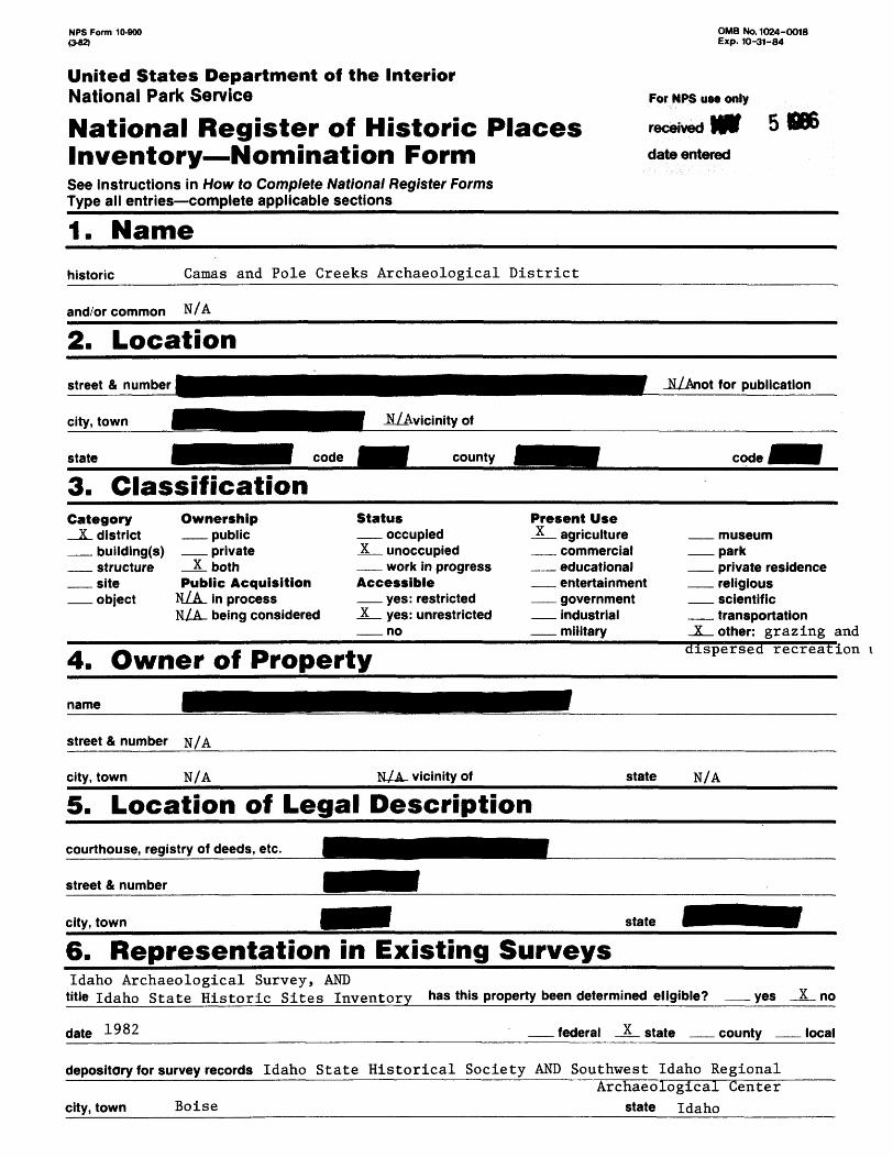
NPS Form 10-900 OMB No. 1024-0018 Exp. 10-31-84 United States Department off the Interior National Park Service For NPS use omy National Register of Historic Places received WV 5 DBS Inventory—Nomination Form date entered See instructions in How to Complete National Register Forms Type all entries—complete applicable sections__________________________________ 1. Name historic Camas and Pole Creeks Archaeological District and/or common N/A 2. Location street & number state JJ/Anot for publication 3. Classification Category Ownership _JL district public building(s) private structure X both site Public Acquisition object N/A in process N/A being considered Status occupied X unoccupied work in progress Accessible yes: restricted X yes: unrestricted no Present Use X agriculture commercial educational entertainment government industrial military museum park private residence religious scientific transportation _X_ other: grazing < 4. Owner of Property dispersed recreation i name street & number city, town N/A N/A vicinity of state N/A 5. Location of Legal Description courthouse, registry of deeds, etc. street & number city, town state 6. Representation in Existing Surveys Idaho Archaeological Survey, AND title Idaho State Historic Sites Inventory "as this property been determined eligible? date 1982 federal x state yes X no county __ local depository for survey records Idaho State Historical Society AND Southwest Idaho Regional city, town Boise Archaeological Center state Idaho
Transcript of National Park Service For NPS use omy National Register of ... · PDF fileNPS Form 10-900 OMB...
NPS Form 10-900 OMB No. 1024-0018 Exp. 10-31-84
United States Department off the InteriorNational Park Service For NPS use omy
National Register of Historic Places received WV 5 DBS Inventory—Nomination Form date enteredSee instructions in How to Complete National Register FormsType all entries—complete applicable sections__________________________________
1. Namehistoric Camas and Pole Creeks Archaeological District
and/or common N/A
2. Location
street & number
state
JJ/Anot for publication
3. ClassificationCategory Ownership_JL district public
building(s) privatestructure X bothsite Public Acquisitionobject N/A in process
N/A being considered
Statusoccupied
X unoccupiedwork in progress
Accessibleyes: restricted
X yes: unrestrictedno
Present UseX agriculture
commercialeducationalentertainmentgovernmentindustrialmilitary
museumparkprivate residencereligiousscientifictransportation
_X_ other: grazing <
4. Owner of Property dispersed recreation i
name
street & number
city, town N/A N/A vicinity of state N/A
5. Location of Legal Descriptioncourthouse, registry of deeds, etc.
street & number
city, town state
6. Representation in Existing SurveysIdaho Archaeological Survey, AND
title Idaho State Historic Sites Inventory "as this property been determined eligible?
date 1982 federal x state
yes X no
county __ local
depository for survey records Idaho State Historical Society AND Southwest Idaho Regional
city, town BoiseArchaeological Center
state Idaho

7. Description
Conditionexcellent
fair*
deteriorated|4|| ruins
unexposed
Check oneX unaltered
altered
Check oneX original site
N/A moved date N/A
Describe the present and original (if known) physical appearance
The Camas and_ Pole^_Creeks Archaeological District is located
plateau dissected by a network of small and large canyons. The area exhibits a high desert climate and is characterized by a sagebrush-grass-juniper environ ment which supports a diverse plant and animal community. Although Camas and Pole creeks have long been noted for their rock art, professional investigation of the area did not begin until 1975. In addition to rock art sites, research efforts between 1975 and 1980 identified prehistoric campsites, lithic scatters, workshops, and rock alignments -- 442 in all. Ten non-contributory historic sites were also recorded and consist mainly of structure remains, cowboy/sheep- herder camps, and historic rock alignments and petroglyphs. Research studies of the district resources have been oriented toward prehistoric settlement- subsistence patterns. Reconnaissance has been supplemented by test excavations. These projects have provided for the development of a working settlement pattern and chronology based on projectile point styles and suppported by radiocarbon dates. Communal hunting is considered to have been a major element of the Upland system and many of the rock alignments are thought to have been associated with hunting activities. Materials recovered from prehistoric camp site tests suggest a coeval use of plant and animal resources and appear to have greatest affinities with materials recovered from sites in the eastern Great Basin. The district boundaries enclose the Camas and Pole creek drainages and reflect the location and distribution of recorded sites in the area. Some sites in the district have been and continue to be impacted by human and animal activity as well as natural factors. However, research has demonstrated that collectively, sites associated with the Camas and Pole Creek drainages can contribute much information to the study of settlement-subsistence patterns in the Uplands.
Environment
The Camas and Pole Creeks Archaeological District is located in the Owyhee Uplands. Together, the two creeks drain a plateau area of approximately 100 square miles. Both creeks are spring fed and flow year round. Camas Creek flows thirteen miles from its point of origin to its juncture with Pole Creek. Pole Creek merges into Deep Creek, which drains into the Owyhee River some fifteen miles to the south. The area ranges in elevation from over 6200 to 4500 feet above sea level. It exhibits a high desert climate and is characterized by a sagebrush-grass-juniper environment which supports a diverse animal community including deer, antelope, and a variety of smaller mammals and avifauna. Winter brings sub-freezing temperatures and heavy snowfalls, which account for much of the area's ten to fifteen inches of annual precipitation. Spring is wet and summer, though usually temperate, can exhibit daytime temperatures of over 100 degrees Fahrenheit, dropping to near freezing at night.

8. Significance
PeriodX prehistoric
_X_ 1400-1 499 ^_ 1500-1 599 _K_ 1600-1 699 _JL_ 1700-1 799
1800-18991900-
Areas of Significance — Check and justify belowX archeology-prehistoric community planning
archeology-historic conservationagriculture economicsarchitecture educationart engineeringcommerce exploration/settlementcommunications industry
invention
landscape architecturelawliteraturemilitarymusicphilosophypol itics/government
religionsciencesculpturesocial/humanitarian theatertransportationother (specify)
Specific dates 4,000 B.C.-1800 A.D. Builder/Architect N/A
Statement of Significance (in one paragraph)
Archaeological research in the Camas and Pole Creeks area has contributed important information concerning the prehistory of southern Idaho. A cultural chronology spanning 6,000 years was discovered, and four archaeological phases have been defined in this time period. Changes in material culture, settlement patterns, population levels, and probably linguistic affiliation have been identified. Future research will refine this information and contribute knowledge concerning the construction and use of rock alignments, the style of petroglyphs, and relationships of the area to Fremont occupations in Utah, and the arrival of the Shoshoni peoples in Southern Idaho.

9. Major Bibliographical References
See continuation sheet.
10. Geographical DataAcreage o« nominated property approximately 33,220 acres
QuaHranglP name See continuation sheet Quadrangle scale See continuatio
UTM References See continuation sheet
A I ' , I I I , I , , I I , I , I i , I B > I I , I , , I ,Zone Easting Northing Zone Easting North
el i I I I , I , i I I i I i I i , I D| i M | i | , , | ,El , I I I , I , , I I , I , | I , | F| , I I I , I , , I ,
Gl , I I I , I , , I I , I , I i i I H| , | | | , | , , | ,
sheet
I img
I I
i i
i i
J.
I
i
, 1
Verbal boundary description and justificationThe Camas and Pole Creeks Archaeological District extends over 33,220 acres and encloses
the drainages of Camas and Pole Creeks. The nomination includes the following tract: ___(see continuation sheet) ._______________________________________________List all states and counties for properties overlapping state or county boundaries
state code N/A county N/A_______________code N/A______
state N/A code N/A county N/A code N/A
11. Form Prepared Byname/title Christen K. Fuhrman, Archaeologist
organization Idaho State Historical Society date June 1, 1985
street & number 610 North Julia Davis Drive telephone (208) 334-3647
city or town Boise state Idaho 83702-7695
12. State Historic Preservation Officer CertificationThe evaluated significance of this property within the state is:
__________ national_____X_ state____ local_______________________________
As the designated State Historic Preservation Officer for the National Historic Preservation Act of 1966 (Public Law 89- 665), I hereby nominate this property for inclusion in the National Register and certify that it has been evaluated according to the criteria and procedures set forth by the National Park Service.
State Historic Preservation Officer signature
title State Historic Preservation Officer date
dateof the National Register
Attest: dattChief of Registration

NPS Form 10-900-a 0-82) OMB No. 1024-OO18
Exp. 10-31-64
United States Department off the InteriorNational Park Service
National Register of Historic Places Inventory—Nomination Form
Camas and Pole Creeks Archaeological District Continuation sheet_____________________Item number 4
OWNER'S OF PROPERTY:
Page 1

NPS Form 10-900-a OMB No. 1024-OO18 (3-82) Exp. 10-31-64
United States Department of the InteriorNational Park Service
National Register of Historic Places Inventory—Nomination FormCamas and Pole Creeks Archaeological District
Continuation sheet_____________________Item number 7__________Page 1
The Uplands are a large upwarped plateau consisting mainly of Tertiary basalt flows and associated rhyolite or welded tuff deposits which are dissected by a network of small and large canyons. Steep rimrock areas with heavy talus slopes and shallow alluvial terraces are typical of some canyons. Others, such as the lower Pole Creek canyon, exhibit smooth rock faces with steep side walls and pinnacle-like features.
Several distinct microenvironmental zones have been noted (Plew 1980). Located over 6200 feet above sea level, the first zone is characterized by flat, low- lying hills covered principally by mountain mahogany, large sagebrush, and grasses. The second zone is slightly lower in elevation and consists of a broad open plateau also covered with sagebrush and grasses. Large meadow areas have formed around major streams and springs. While at the present time this area supports some of the major cattle ranching operations in the Uplands, it is the third microenvironmental zone that appears to have been favored for habitation areas in the past. This area, between 5100 and 5700 feet above sea level, contains small basalt rimrock canyons and exhibits sagebrush, grasses, and juniper.
A number of the district's plants, including camas and biscuitroot, were used as food sources by aboriginal peoples. Steelhead trout, chinook salmon and other fish were reportedly found in the Owyhee River and its tributaries and contributed to native subsistence. Mammals such as antelope, mountain sheep, deer, rabbits, and ground squirrels were also available (Plew 1980).
IContext and Composition
Investigations in the Camas and Pole Creeks Archaeological District have identified 452 sites, 442 of which are prehistoric with the remaining ten being historical, non-contributory. Research has documented an occupation period spanning the last 6000 years (Plew 1980).
Identified prehistoric sites include 15 camp sites, generally characterized by an abundance of lithic tools and debris, pottery and ground stone. Campsites are usually found on or along stream terraces. Two hundred thirty-one lithic scatters have been recorded, most of which are situated on slopes and small terraces between the canyon floors and rimrock. These sites consist of relatively small areas of lithic debris. Workshops, sites exhibiting intense lithic debris from the early stages of tool manufacture as well as unfinished tool forms, account for five of the district's sites and are found above and beyond the canyon rimrock. Thirty-five rockshelters and caves, mostly shallow openfaced overhangs, have been located within areas of broken basalt rimrock. Fifty-two rock art sites are comprised entirely of petroglyphs and are most frequently found on relatively smooth basalt faces of canyon walls below the rimrock. One hundred sixty-six sites record rock alignments, which can be

NFS Form 10-900-a (3-82)
OMB No. 1024-OO18 Exp. 1O-31-84
United States Department of the InteriorNational Park Service
National Register of Historic Places Inventory—Nomination Form
Camas and Pole Creeks Archaeological District Continuation sheet Item number 7 Page 2
linear, circular, semi-circular, or cairn-like in nature. Rock alignments can occur singly or as groupings of rock structures and are frequently found along modern game trails or on rim projections which drop steeply to the canyon. Communal hunting is considered to have been a major element of the Upland system and many of the rock alignments are thought to have been associated with hunting activities (Plew 1980). Individual descriptions of the prehistoric sites are summarized in the Table.
Euro-American occupation of the Uplands began in 1863 with the discovery of gold in the Owyhee Mountains, which in turn brought an influx of miners, settlers, and cattle and sheep.
Archaeological Activities
Plew's investigations from 1975 to 1980 represent the first systematic examina tion of the Camas and Pole creek drainages and are responsible for recording nearly all of the District's sites. However, the area has long been recognized for its cultural values, specifically for its rock art. Erwin noted rock art along Camas Creek in his 1930 report of rock art locations (Erwin 1930). In 1968 the BLM withdrew Camas Creek, by virtue of its rock art, from future mining and development interests under the authority of the Classification and Multiple Use Act. Local amateur archaeologists belonging to the Idaho Archaeo logical Society were the first to field survey the Camas Creek drainage (Norquist and Moore 1975). Through their efforts the archaeological potential of the Camas and Pole creek area was brought to the attention of professional archaeologists.
In 1975 the BLM sponsored a joint study by Boise State University and the Indiana University Museum to perform an intensive cultural resource inventory of Camas Creek. One hundred fifty-one sites were recorded (Plew 1976). Related investigations during the summers of 1976-1979, sponsored by the Idaho State Historical Society, centered on the Pole Creek drainage and stretches of adjacent creeks. Large open areas that exist between drainages were also inves tigated using arbitrarily selected mile-wide transects. The 1977 reconnaissance on upper Pole Creek in the vicinity of Mud Flat produced 112 site recordings. An additional 163 sites were located in 1978 throughout the remainder of the drainage (Plew 1978). The type of survey coverage remained uniform throughout the investigations. Two-person teams spread 15-20 meters apart walked parallel swaths across designated areas. Stream or canyon bottoms and adjacent slopes and talus rimrock areas were examined to a distance of 100-200 meters beyond the canyon rim. Open areas were given less intensive coverage. Small collections were taken when deemed pertinent to definition of site type or chronological questions.

NPS Form 10-900-a OMB No. 1024-OO18 (3-82) Exp. 10-31-64
United States Department off the InteriorNational Park Service
National Register of Historic Places Inventory—Nomination Form
Camas and Pole Creeks Archaeological District Continuation sheet_____________________Item number 7___________Page 3____
In order to facilitate evaluation and interpretation of cultural resources in the Camas Creek drainage, five sites were tested in conjunction with the 1975 survey efforts (Plew 1976). A cave (10-OE-596), a lithic scatter (10-OE-695), two campsites (10-OE-602 and 680), and a rockshelter (10-OE-616) were examined to determine the extent of cultural deposits. A single test pit, excavated in arbitrary 10-cm levels, was dug at each site. Investigations produced little from the cave , which had been previously "potted," but large quantities of debris were recovered from the lithic scatter. Camas Creek had eroded the major portion of 10-OE-680 but the other campsite produced a culture-bearing deposit of 60 cm including metates, projectile points, lithic debris, animal bone, and pottery. Similar materials were recovered at the rockshelter from a deposit of 70 cm.
In 1978 the BUM contracted with Plew at the Idaho State Historical Society to perform test excavations at two open campsites (10-OE-1305 and 1306) and a rockshelter (10-OE-1324) at Pole Creek and three open camps (10-OE-602, 688 and 697) at Camas Creek. Factors such as relative abundance of surface material and increasing vandalism or animal disturbance were considered in selecting sites for investigation. The purpose of the tests was to determine the extent and nature of sub-surface cultural deposits and to recover chronological informa tion. Being the first systematic examination of Archaic campsites in the Owyhee Uplands, these tests provided an opportunity to test hypotheses concerning such sites in relation to the local settlement pattern. The tests generated a detailed publication about the work which noted that the sites are characterized by a generalized tool assemblage representing a broad range of activities; that the presence of projectiles, animal bones, and ground stone suggest coeval use of plant and animal resources; and that the greatest material culture affinities appear to be with sites in the eastern Great Basin (Plew 1979a).
During the summer of 1979 the Idaho State Historical Society provided for Plew's return to the Pole Creek area to investigate two additional sites. The first, an apparent campsite (10-OE-1673) at the confluence of Deep and Pole creeks, exhibited surface materials of chipped-stone artifacts, groundstone, pottery, and lithic debris. A test consisting of 11 square-meter units indicated a cultural deposit of almost 50 cm but concluded more intensive investigations were needed to determine the size and specific nature of the site (Plew 1980).
Simultaneously conducted with the 10-OE-1673 test were excavations at Nahas Cave (10-OE-1674) mmHlHHV on Pole Creek. Further investigations at this site werea^oconducted in 1980. A deposit over 140 cm deep yielded a total of 350 artifacts -- projectile points, scrapers, knives, ground stone, bone tools, potsherds, stone pipe fragments, and fired clay cylinders (Plew 1981; Plew and Woods 1980). Cultural features included 13 hearths and one fiber-filled pit. Seven radiocarbon dates were obtained from Nahas Cave which span a period of 5990-260 B.P.

NPS Form 10-900-a OMB No. 1024-OO18 (3-82) Exp. 10-31-64
United States Department of the InteriorNational Park Service
National Register of Historic Places Inventory—Nomination FormCamas and Pole Creeks Archaeological District
Continuation sheet_____________________Item number 7__________page 4
Test excavations conducted in the Camas and Pole Creeks area indicate cultural deposits have some depth and can provide valuable scientific information. Twelve sites have been test excavated, including seven open campsites, one workshop, two rockshelters, and two caves. These investigations have provided for the development of a working chronology and settlement pattern consisting of four temporal phases: Camas Creek I (4000 BC - 700 BC), Camas Creek II (700 BC - AD 600), Camas Creek III (AD 600 - AD 1200), and Camas Creek IV (AD 1200 - Historic Period) (Plew 1980). The sequence is based upon association of cultural remains with projectile point styles as they relate to established dates for like projectiles from the Northern Great Basin (Hester and Heizer 1973). The radiocarbon dates recovered from Nahas Cave confirm the Camas Creek I - IV phase sequence (Plew 1979b) and constitute the first radiocarbon sequence for Owyhee County.
Boundaries
Archaeological investigations have demonstrated that collectively, the dis trict's sites can provide valuable information regarding settlement-subsistence patterns in the Uplands. The boundaries have been designed to enclose the drainages of Camas and Pole creeks from origin to mouth as well as the archaeological sites recorded in these areas. Although many of the sites occur in the creek canyons, some are located beyond the canyon rims and in open areas between the drainages. Thus, boundaries have been extended beyond the major stream courses to include principal tributaries and basins associated with Camas and Pole creeks. The boundaries reflect the extent and location of 452 recorded sites distributed over 33,220 acres.
The district be
The majority of the district's sites-remain relatively intact. Generally, com pared to other sites in Idaho, these sites are considered to be in excellent condition. However, some sites in the district have been and continue to be impacted by human and animal activity as well as by natural factors. Vandalism, rodent burrowing, cattle activity, and stream erosion have impacted some sites. Impacts due to archaeological excavations have been limited to twelve sites. As previously described, these excavations have yielded radiocarbon dates and helped to produce a settlement-subsistence model useful to scientific research in the area.

NFS Form 10-900-a 0-82)
OMB No. 1024-OO18 Exp. 10-31-34
United States Department off the InteriorNational Park Service
National Register of Historic Places Inventory—Nomination Form
Camas and Pole Creeks Archaeological District Continuation sheet Item number 8 Page 1
The archaeological sites in the Camas and Pole Creeks area have been intensively studied by Dr. Mark Plew since 1975. This research has resulted in numerous publications (Plew 1976, 1978, 1979a, 1979b, and 1980). Four prehistoric phases have been identified through this research; these are Camas Creek I, Camas Creek II, Camas Creek III, and Camas Creek IV. Camas Creek I is defined by the presence of Humboldt and Pinto projectile points and is thought to date between 4000 B.C. and 700 B.C. Little is known of the lifeways of the people living in this partof Idaho at this time period. Camas Creek I sites are small and are located mftftffffffffffffff Scattered flakes and a few diagnostic projectilepointsarea^nna^aretound. Camas Creek II Phase is identified by Elko Series projectile points and dates from 700 B.C. to 600 A.D. The sites are larger and more varied than those of Camas Creek I. They include campsites, lithic scatter, and rock alignments. The artifacts found on these sites include projectile points, scrapers, drills, and a few ground stone implements. Little is known of the relationships between these sites, and consequently little is known about the lifestyles of the people who inhabited them.
Camas Creek III Phase dates from 600 A.D. to 1200 A.D. A considerable amount of information is known about this phase, and the majority of the archaeological sites in the district are assigned to it. The artifact assemblage is composed of Rose Spring, Eastgate, and Camas Creek projectile points, bifaces, scrapers, mortars, metates, manos, pestles, and pottery. A number of site types have been identified including summer camps, winter encampments, hunting sites, workshops,
types reflecting the numerous activities occurring at these localities. Summer campsites are located _______________________________________ Camas, biscuitroot, and Mtterroot were the principal plants harvested. The winter encampments in the WJj^ffffff and the summer campsites in the
appear to be the two principal seasonal living sites.
Smaller sites_^re__as_socj.ated with the two base, camps. Numerous hunting sites
ments designed to help herd animals, usually antelope or bighorn sheep, to a particular point along the rfmrock where they were trapped and killed. The rock alignments contain long rock walls or fences, rock blinds, and rock cairns. In addition to the hunting sites many localities are workshops where stone tools were made. There are also plant-collecting localities which are associated with the principal base camps. These sites_contain ground stone tools used in processing bulbs and seeds. Finally, HIHHIIIHV numerous petroglyphs have been located, and many are associated with this phase.

NPS Form 10-900-a OMB No. 1024-0018 (3-82) Exp. 10-31-34
United States Department off the InteriorNational Park Service
National Register of Historic Places Inventory—Nomination FormCamas and Pole Creeks Archaeological District
Continuation sheet______________________Item number 8__________Page 2
The last phase, Camas Creek IV, begins around 1200 A.D. and lasts until historic times. Desert Side Notched and Cottonwood projectile points are characteristic. While the settlement pattern described for Camas Creek III Phase probably ap plies to Camas Creek IV, it appears there are fewer sites, and they are not occupied with the same intensity as the earlier occupations. These changes suggest there are fewer people in the area after 1200 A.D. Some people represented by Camas Creek IV Phase are Shoshoni.
Since 1975 a great deal has been learned about the peoples who lived in the Camas and Pole Creeks area during the last 6,000 years. However, numerous questions remain unanswered. One of the most important concerns the origins of the Shoshoni peoples. It is generally thought by archaeologists that the Shoshoni peoples moved into southern Idaho sometime around 1200 A.D. However, some people believe the Shoshoni have been in Idaho for thousands of years earlier than this (Swanson 1972), and others think they are very recent migrants into the region (Butler 1981). The Camas Creek and Pole Creek area is particularly well suited for studying this problem. It is possible that the observed differences between Camas Creek III and Camas Creek IV are the result of Shoshoni migrations into the area. If this is true, then detailed analysis of the differences between these two phases ought to suggest not only when but also why the Shoshoni moved into the area. Additionally, the petroglyphs may reflect Shoshoni and pre-Shoshoni occupations. Recent research with petroglyphs in southern Idaho has suggested that two styles are present. whether these represent Shoshoni and pre-Shoshoni peoples is not known with certainty, but it has been suggested, and the Camas and Pole creek petroglyphs will contribute important information concerning this question. If Camas Creek IV does represent Shoshoni peoples since 1200 as seems likely, then studies of the phase will give archaeologists an opportunity to determine the lifeways of these peoples prior to contact with European settlers. This is extremely important because Shoshoni society was drastically altered during the nineteenth century by European diseases, the fur trade, and the settlement of the area by immigrants.
There are numerous questions concerning the Camas Creek III Phase that need to be answered. One question concerns the presence of Fremont-like pottery at Camas Creek III sites. Why does this pottery occur in the area? Was it made by the local people, was it traded from the south, or are the Camas Creek III people related to the Fremont people in Utah? Also, most of the sites in the district date from Camas Creek III times. Why is this the case? What caused the increase in population from Camas Creek II times? What caused the decrease in population after Camas Creek III times?
Finally, much more information is needed about the two early phases in the area. At the moment little is known about the peoples responsible for Camas Creek I and Camas Creek II phases.

NPS Form 10-900-a (3-82)
OMB No. 1024-OO18 Exp. 10-31-84
United States Department of the InteriorNational Park Service
National Register of Historic Places Inventory—Nomination Form
Camas and Pole Creeks Archaeological District Continuation sheet Item number 8 Page 3
UJ.•Of special interest in the district are the 166 rock alignments. The rock alignments are rock walls that are linear, circular, or semi-circular usually associated with rock cairns and located on canyon rims. One group of alignments, the Pole Creek complex (10 OE 1319), covers an area approximately meters long and is between ̂ ^BJBBjneters in width. The complex is located IHj^B^IHHHmiiimmHV Rock walls have been built across the point from one canyon rim to the other. Openings were left in the walls. Plew suggested the complex was used for hunting and that the animals, probably antelope, were driven towards the complex and onto the projecting rimrock. Hunters could hide behind the rock walls, and as the animals ran through the openings or jumped the walls, they could be killed with bows and arrows or with spears and atlatls.
Many of the rock features may have other uses besides hunting. It is possible that some have religious significance or were used to mark the position of different constellations or movements of the sun or moon. The large number of rock alignments and cairns in the district will allow researchers to study how they were made and to determine their use.
NPS Form 10-900-a (3-82)
OMB No. 1024-OO18 Exp. 10-31-34
United States Department off the InteriorNational Park Service
National Register of Historic Places Inventory—Nomination Form
Camas and Pole Creeks Archaeological District Continuation sheet Item number 9 Page
9. MAJOR BIBLIOGRAPHIC REFERENCES
Butler, B. Robert1981 When Did The Shoshone Begin to Occupy Southern Idaho?:
Essays on Late Prehistoric Cultural Remains from the Upper Snake and Salmon River County. Occasional Papers of the Idaho Museum of Natural History. No. 32, Pocatello.
Erwin, Richard P.1930 Indian Rock Writing in Idaho. State Historical Society
Idaho Biennial Report No. 12, pp. 35-111.
Hester, Thomas R., and Robert F. Heizer1973 Review and Discussion of Great Basin Projectile Points:
Forms and Chronology. Archaeological Research Facility. Department of Anthropology. University of California. Berkeley.
Norquist, William T., T. Moore and others1975 Archaeological Survey, Camas Creek, Owyhee County.
Report of the Great Basin Chapter, Idaho Archaeological Society Papers, Special Publication, No. 2.
Plew, Mark G.1976 An Archaeological Inventory of the Camas Creek Drainage
Basin, Owyhee County, Idaho. Archaeological Reports No. 1, Boise State University. Boise.
1978 An Archaeological Survey of Pole Creek, Owyhee County, Idaho. Archaeological Reports No. 4, Boise State University. Boise.
1979a Archaeological Excavations at Camas and Pole Creeks,Southcentral Owyhee County, Idaho. Archaeological Reports No. 5, Boise State University. Boise.
1979b Aboriginal Hunting Complexes in the Owyhee Uplands, Idaho. Masterkey 53(3): 108-111.
1980 Archaeological Investigations in the Southcentral Owyhee Uplands, Idaho. Archaeological Reports No. 7, Boise State University. Boise.

NFS Form 10-900-a (3-82)
OMB No. 1024-OO18 Exp. 10-31-84
United States Department off the InteriorNational Park Service
National Register of Historic Places Inventory — Nomination Form
and Pole Creeks Archaeological District Continuation sheet Item number Page 2
1981 A Preliminary Report on Archaeological Excavations at Nahas Cave . Idaho Archaeologist 4(3) : 1 - 7 .
1985 A Preliminary Settlement Pattern for the Southcentral Owyhee Uplands, Idaho. PhD Disertation, Department of Anthropology, Indiana University.
Plew, Mark G. , and James Woods1980 Fired Clay Cylinders from Nahas Cave,
Idaho. Idaho Archaeologist 4(1):8-10').Southwestern
Swanson, Earl H. , Jr. 1972 Birch Creek: Human Ecolog in the Cool Desert of
the Northern Rocky Mountains. 9000 B.C. - A.D. 1850. Pocatello: Idaho State University Press.
NPS Form 10-900-a (3-82) OMB No. 1024-OO18
Exp. 10-31-34
United States Department off the InteriorNational Park Service
National Register of Historic Places Inventory—Nomination FormCamas and Pole Creeks Archaeological District
Continuation sheet Item number 10 Page
The Camas and Pole Creeks Archaeological District is represented by the following UTM references:
Zone 11
A. B. C. D. E. F. G. H. I. J. K. L. M. N. 0. P.Q.R.S.T.U.V.W.X.Y.Z.
AA. BB. CC. DD. EE. FF. GG. HH. II.
mE /mE /fmE /mE /mE /mE /mE /[mE /mE /
f mE /mE /mE /mE /mE /.mE /
/F mE /InE /[mE /!mE /|mE /mE /
/ [mE /mE /mE /(mE /mE /,mE /'mE /mE /mE /mE /
fmN f mN
,mN mN ,mN mN mN mN mN
( mN |mN ;mN ,mN ,mN mN mN mN mN mN mN mN ImN mN mN mN mN mN mN mN 'mN
mN mN mN mN

NPS Form 10-900-a (3*2)
OMB No. 1024-OO18 Exp. 10-31-64
United. States Department of the InteriorNational Park Service
National Register of Historic Places Inventory—Nomination Form
Camas and Pole Creeks Archaeological District Continuation sheet Item number 10 Page 2
ITEM 10, GEOGRAPHICAL DATA:
Quadrangles in the Camas and Pole Creeks Archaeological District
7.5 minute 7.5 minute 7.5 minute 7.5 minute 7.5 minute


Camas and Pole Creeks Archaeological District Petroglyph panels at 10-OE-602 Owyhee County, Idaho
Photograph by Mark Plew 1976
Negative on file at the Southwest Idaho Regional Archaeological Center, Boise, Idaho
Photograph 1 of 10


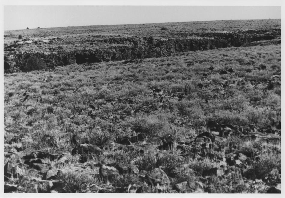
Camas and Pole Creeks Archaeological District 10-OE-602 General view up Camas Creek. Site
Lower left along creek Owyhee County, Idaho
Photograph by Mark Plew 1976
Negative on file at the Southwest Idaho Regional Archaeological Center, Boise, Idaho
View from southwest
Photograph 2 of 10


Camas and Pole Creeks Archaeological District Petroglyphs at 10-OE-602 Owyhee County, Idaho
Photograph by Mark Plew 1976
Negative on file at the Southwest Idaho Regional Archaeological Center, Boise, Idaho
Photograph 3 of 10

•%.v
s?

Camas and Pole Creeks Archaeological District 10-OE-602 Petroglyphs depicting shield figure
at left Owyhee County, Idaho
Photograph by Mark Plew 1976
Negative on file at the Southwest Idaho Regional Archaeological Center, Boise, Idaho
Photoeranh 4 of 10

••

Camas and Pole Creeks Archaeological District 10-OE-714 Semi-circular rock alignments Owyhee County, Idaho
Photograph by Mark Plew 1976
Negative on file at the Southwest Idaho Regional Archaeological Center, Boise, Idaho
Photograph 5 of 10


Camas and Pole Creeks Archaeological District Cave at 10-OE-596 Owyhee County, Idaho
Photograph by Mark Plew 1976
Negative on file at the Southwest Idaho Regional Archaeological Center, Boise, Idaho
Photograph 6 of 10

Camas and Pole Creeks Archaeological District 10-OE-715 Open lithic scatter along rim of
canyon Owyhee County, Idaho
Photograph by Mark Plew 1976
Negative on file at the Southwest Idaho Regional Archaeological Center, Boise, Idaho
Photograph 7 of 10

*...*

Camas and Pole Creeks Archaeological District 10-OE-593 Rock cairns Owyhee County, Idaho
Photograph by Mark Plew 1976
Negative on file at the Southwest Idaho Regional Archaeological Center
Photograph 8 of 10


Camas and Pole Creeks Archaeological District 10-OE-669 Open lithic scatter Owyhee County, Idaho
Photograph by Mark Plew 1979
Negative on file at the Southwest Idaho Regional Archaeological Center, Boise, Idaho
Photograph 9 of 10


Camas and Pole Creeks Archaeological District Circular rock alignment, vicinity of Camas Creek Owyhee County, Idaho
Photograph by Mark Plew 1976
Negative on file at the Southwest Idaho Regional Archaeological Center, Boise, Idaho
Photograph 10 of 10