National Inventory of Greenhouse Gas Emissions and ... - INCAS · INDONESIAN NATIONAL CARBON...
66
National Inventory of Greenhouse Gas Emissions and Removals on Indonesia’s Forests and Peatlands MINISTRY OF ENVIRONMENT AND FORESTRY RESEARCH, DEVELOPMENT AND INNOVATION AGENCY © 2015
-
Upload
duongxuyen -
Category
Documents
-
view
219 -
download
1
Transcript of National Inventory of Greenhouse Gas Emissions and ... - INCAS · INDONESIAN NATIONAL CARBON...

National Inventory of Greenhouse Gas Emissions and Removals on
Indonesia’s Forests and Peatlands
MINISTRY OF ENVIRONMENT AND FORESTRYRESEARCH, DEVELOPMENT AND INNOVATION AGENCY© 2015
Indonesian National C
arbon Accounting System
(INC
AS) | N
ational Inventory of Greenhouse G
as Emissions and R
emovals on Indonesia’s Forests and Peatlands


National Inventory of Greenhouse Gas Emissions and Removals on
Indonesia’s Forests and Peatlands
Indonesian National Carbon Accounting System (INCAS)
MINISTRY OF ENVIRONMENT AND FORESTRYRESEARCH, DEVELOPMENT AND INNOVATION AGENCY
© 2015

INDONESIAN NATIONAL CARBON ACCOUNTING SYSTEM (INCAS)
National Inventory of Greenhouse Gas Emissions and Removals on Indonesia’s Forests and Peatlands
Authors:Haruni Krisnawati, Rinaldi Imanuddin, Wahyu Catur Adinugroho, Silver Hutabarat
National Reviewers:Rizaldi Boer, Ruandha Agung Sugardiman, Teddy Rusolono, Chairil Anwar Siregar, Maswar Bahri
International Reviewers:Michael Parsons, Robert Waterworth, Thomas Harvey, Geoff Roberts, Nikki Fitzgerald
Contributors:National Institute of Aeronautics and Space, Directorate General of Forestry Planning and Environmental Management of the Ministry of Environment and Forestry, Agricultural Research and Development Agency of the Ministry of Agriculture
© 2015 Ministry of Environment and ForestryResearch, Development and Innovation Agency
ISBN: 978-979-8452-64-2
Citation is permitted with acknowledgement of the source:Krisnawati, H., Imanuddin, R., Adinugroho, W.C. and Hutabarat, S. 2015. National Inventory of Greenhouse Gas Emissions and Removals on Indonesia’s Forests and Peatlands. Research, Development and Innovation Agency of the Ministry of Environment and Forestry. Bogor, Indonesia.
Published by:Research, Development and Innovation Agency of the Ministry of Environment and ForestryKampus Badan Penelitian, Pengembangan dan InovasiJl. Gunung Batu No. 5, Bogor 16610, IndonesiaTelp : +62-251 7520068Email : [email protected] | [email protected] : http://www.forda-mof.org
Support for this publication was provided by the Australian Government through a partnership with the Center for International Forestry Research (CIFOR). Support was also provided through the former Indonesia–Australia Forest Carbon Partnership (IAFCP).

National Inventory of Greenhouse Gas Emissions and Removals on Indonesia’s Forests and Peatlands | iii
It gives me great pleasure to present this important publication from the Indonesian National Carbon Accounting System, commonly known as the INCAS.
At a public seminar in Jakarta on 27 March 2015, I formally endorsed the INCAS as Indonesia’s national platform for greenhouse gas accounting to help meet our future measurement, reporting and verification (MRV) requirements in the land based sectors. At this seminar, I committed to use INCAS to produce a comprehensive account of greenhouse gas (GHG) emissions and removals across the Indonesian archipelago in time for the United Nations Framework Convention on Climate Change (UNFCCC) twenty-first conference of the parties (COP21) in Paris during December 2015. This report delivers on that commitment and provides the most detailed national level account of net greenhouse gas emissions ever produced for Indonesia’s forest and peatlands.
The Indonesian Government has committed to an ambitious emissions reduction target of 26 to 41 percent below business as usual levels by 2020. With a significant proportion of our total emissions being generated by land-based activities, this sector is a major focus of our emissions reduction efforts.
This is why we are developing the INCAS to provide a detailed and credible account of annual GHG emissions and removals nation-wide. This will play a key role in helping us to meet our future MRV requirements, including for activities to reduce emissions from deforestation, forest degradation and other forest land management (REDD+). Additionally, the detailed information generated by the INCAS will empower us to make informed decisions on the design, implementation and monitoring of effective interventions to reduce greenhouse gas emissions and manage our lands more sustainably.
Contained herein are two publications that jointly present the INCAS framework, methodologies and results from the development of the system at the national level for the first time. The first publication includes a detailed account of annual GHG emissions and removals from all of Indonesia’s forest and peatlands, as a result of the common REDD+ activities of deforestation, forest degradation, sustainable management of forests and enhancements of forest carbon stocks. This includes emissions from peat fire and biological oxidation, a significant source of GHG emissions in our country. The second publication outlines the INCAS methodology that has been used to generate these national results. The methodology has been outlined transparently and in detail to ensure the credibility of the INCAS approach.
FOREWORD

iv | National Inventory of Greenhouse Gas Emissions and Removals on Indonesia’s Forests and Peatlands
I congratulate the Research, Development and Innovation Agency and the Directorate General of Forestry Planning in developing the INCAS to date. I would also like to acknowledge the valuable contributions of the National Institute for Aeronautics and Space (LAPAN) and the many other national agencies and academic institutions that have been involved in the development of the system. We express our strong appreciation to the Australian Government for their longstanding and intensive support for the development of the INCAS, which is currently delivered through our close working partnership with the Center for International Forestry Research (CIFOR) and previously through the Indonesia-Australia Forest Carbon Partnership (IAFCP).
Now that the initial development phase of the system is complete, the experiences and findings of the INCAS should be used as a basis for implementation of Indonesia’s GHG accounting system. I look forward to seeing the expansion of the INCAS to cover all agriculture, forestry and other land use (AFOLU) activities and the full operationalization of the system across the Ministry, to help meet our official GHG data and reporting requirements.
Jakarta, November 2015Minister of Environment and Forestry
Dr. Ir. Siti Nurbaya, M.Sc

National Inventory of Greenhouse Gas Emissions and Removals on Indonesia’s Forests and Peatlands | v
The global community is working towards a new agreement to address the impacts of climate change. At the United Nations Framework Convention on Climate Change (UNFCCC) twenty-first conference of the parties (COP21) in Paris in December 2015, parties will seek to finalize a new post-2020 agreement on climate change. For this agreement to be effective, it must include emissions reduction pledges from countries and robust emissions measurement, reporting and verification (MRV) requirements to ensure that these pledges are met.
To meet these emissions reporting requirements, the Government of Indonesia (GOI) is developing the Indonesian National Carbon Accounting System (INCAS) as the national platform for greenhouse gas (GHG) accounting. The INCAS is designed as a Tier 3 level GHG accounting system that provides a systematic and nationally consistent approach to monitoring GHG emissions and removals in the land based sectors. The INCAS generates detailed information on historic, present time and future projections of GHG emissions and removals. This level of detail will allow Indonesia to better understand, manage and ultimately reduce GHG emissions in a targeted and effective manner.
On 27 March 2015 at a public seminar in Jakarta, the Minister of Environment and Forestry endorsed the INCAS as Indonesia’s GHG accounting system for the land based sectors, including REDD+ activities. This report has been prepared to meet the commitment made by the Minister at the seminar to finalize the national results from the INCAS in time for reporting at COP21 in Paris. As per UNFCCC requirements, the INCAS provides nationally consistent GHG data that can be used as part of Indonesia’s national GHG inventory and also as an input for updating Indonesia’s Forest Reference Emissions Level or Forest Reference Level (FREL/FRL) and an effective Intended Nationally Determined Contribution (INDC).
This document presents these first national level results from INCAS; an annual account of historical GHG emissions and removals from Indonesia’s forest and peatlands for the period of 2001 to 2012. These results include annual estimates of net GHG emissions from key activities occurring on forest lands (REDD+ activities): (i) deforestation, (ii) forest degradation, (iii) sustainable management of forests, and (iv) enhancement of forest carbon stocks. Emissions from biological oxidation and fires on disturbed peatlands are also included. All relevant greenhouse gases and carbon pools are accounted for.
EXECUTIVE SUMMARY

vi | National Inventory of Greenhouse Gas Emissions and Removals on Indonesia’s Forests and Peatlands
The methodologies used follow the Intergovernmental Panel on Climate Change’s (IPCC) guidelines and consist of a combination of Tier 3 /Approach 2 methods for forest lands and Tier 2/Approach 2 methods for peatlands and both use a mixture of Indonesia specific data and other default values. For forest lands, an event-driven process has been used to quantify the impact of forest disturbances on forest condition from which GHG emissions and removals are derived. This approach tracks the flow of carbon between the different carbon pools in the forest and ultimately estimates the net GHG emissions released into the atmosphere. For peatlands, emissions from biological oxidation and fires were estimated based on Indonesia specific emission factors and also IPCC default values applied to the area of affected peatlands. This peat GHG emissions estimation will be improved in the future using a Tier 3 method similar to the current forest land component.
The results from this analysis show significant annual variation in GHG emissions and removals on forest and peatlands across the whole country; reflecting the impact of historical land management, current practices and fluctuations in weather conditions, particularly dry years with higher incidences of fire. Net GHG emissions reported include all lands, all carbon pools, relevant gases and activities at all scales.
The year with greatest GHG emissions was 2006 with a total of 1.5 Gt CO2-e, and the lowest was in 2001 with 0.8 Gt CO2-e. Generally, emissions from biological oxidation of peatlands were the largest single source of emissions. The three provinces with the highest average emissions were Riau, Central Kalimantan and Papua.
Emissions from the forest components of REDD+ activities (i.e. excluding soil/peat) were dominated by forest degradation. The year with highest net emissions from forest degradation was 2006, with 0.53 Gt CO2-e of GHG emissions released to the atmosphere across all of Indonesia. There is substantial fluctuation between GHG emissions from other REDD+ activities, partly reflecting the definitions used for each activity.
Net GHG emissions from lands subject to deforestation reached a high of 288 million t CO2-e in year 2009 and a low of 28 million t CO2-e in year 2001. Net GHG emissions from lands subject to sustainable management of forests (SMF) range from 1.4 million t CO2-e in year 2001 to 11.6 million t CO2-e in year 2009. Enhancement of forest carbon stocks removed a total of 126 million t CO2-e of GHG over the period from 2001 to 2012.
Annual emissions from peatlands (estimated from peat biological oxidation and fires) were 395 million t CO2-e on average during the reporting period (2001-2012), peaking in year 2006 with 502 million t CO2-e. Emissions from mineral soils (from soil organic carbon pool) were 8 million t CO2-e on average during the reporting period, peaking in year 2006 with 17 million t CO2-e.

National Inventory of Greenhouse Gas Emissions and Removals on Indonesia’s Forests and Peatlands | vii
The INCAS delivers more detailed and hence useful results than other simpler GHG accounting approaches (e.g. applying Tier 1 or 2 methods). For example, in addition to the results already listed above, annual GHG emissions and removals are produced according to different forest type, forest function, soil type, subsequent land use and carbon pool. Furthermore, with these results from INCAS, for the first time it is possible to break down Indonesia’s national GHG emissions profile into its constituent elements of forest carbon stock change; non-CO2 emissions from biomass burning; CO2 and non-CO2 emissions from mineral soil; biological oxidation, direct N2O emissions, dissolved organic carbon (DOC) and CH4 emissions from disturbed peatlands; and CO2 and non-CO2 emissions from peat fire.
The results presented in this document provide the most comprehensive national level account of annual GHG emissions and removals from forests and peatlands that has ever been produced in Indonesia. This is also the first time that national results of net GHG emissions and removals have been generated and presented for each of the key REDD+ activities in Indonesia. This level of detail provides credible information to empower GOI decision-makers to make informed decisions about the management of Indonesia’s GHG emissions profile and to design mitigation actions that align with other national needs, including sustainable land use planning purposes.

viii | National Inventory of Greenhouse Gas Emissions and Removals on Indonesia’s Forests and Peatlands
TABLE OF CONTENTS
FOREWORD ........................................................................................................................ iii
EXECUTIVE SUMMARY .................................................................................................... v
LIST OF TABLES .................................................................................................................. x
LIST OF FIGURES ............................................................................................................... xi
1. INTRODUCTION ........................................................................................................... 1
1.1 Background ............................................................................................................... 1
1.2 Objectives .................................................................................................................. 3
2. KEY FEATURES OF INCAS.......................................................................................... 4
2.1 TACCC ...................................................................................................................... 5
2.2 Forecasting ............................................................................................................... 5
2.3 Flexibility .................................................................................................................. 5
2.4 Scenario Analysis .................................................................................................... 6
2.5 Reporting .................................................................................................................. 6
2.6 Continuous Improvement ..................................................................................... 6
2.7 Verification ................................................................................................................ 6
2.8 Uncertainty................................................................................................................ 6
2.9 Redd+ Activities ....................................................................................................... 7
2.10 Frel/Frl Development ............................................................................................ 7
3. METHODOLOGY .......................................................................................................... 8
3.1 Definitions Used for Analysis ................................................................................ 8
3.1.1 Forests ............................................................................................................. 9
3.1.2 Non-Forest Lands ......................................................................................... 9
3.1.3 Peatlands ...................................................................................................... 11
3.1.4 Deforestations.............................................................................................. 11
3.1.5 Forest Degradation ..................................................................................... 12

National Inventory of Greenhouse Gas Emissions and Removals on Indonesia’s Forests and Peatlands | ix
3.1.6 Sustainable Management of Forests ........................................................ 12
3.1.7 Enhancement of Forest Carbon Stocks .................................................... 13
3.1.8 Role of Conservation .................................................................................. 13
3.2 Data Inputs .............................................................................................................. 15
3.3 Procedures ............................................................................................................... 16
3.3.1 Calculation of Area Change ...................................................................... 17
3.3.1.1 Forest Lands ................................................................................. 17
3.3.1.2 Peatlands ....................................................................................... 19
3.3.1.3 Mineral Soils ................................................................................. 20
3.3.2 Calculation of GHG Emissions and Removals ....................................... 21
3.3.2.1 Estimating GHG Emissions and Removals from Forests ..... 23
3.3.2.2 Estimating GHGs Emissions from Soils ................................... 24
4. RESULTS ........................................................................................................................ 29
4.1 Emissions from Forest Components ................................................................... 30
4.2 Emissions from Soils .............................................................................................. 33
4.2.1 Emissions from Peat (Organic Soils) ........................................................ 33
4.2.2 Emissions from Mineral Soils ................................................................... 35
DISCUSSION ...................................................................................................................... 37
IMPROVEMENT PLAN ................................................................................................... 39
REFERENCES ...................................................................................................................... 42
APPENDIX ........................................................................................................................... 45

x | National Inventory of Greenhouse Gas Emissions and Removals on Indonesia’s Forests and Peatlands
LIST OF TABLES
Table 1. Land cover classes defined by MoEF’s land cover map and their relationship with the IPCC categories................................................................. 10
Table 2. Definition of REDD+ activities and the rules used for spatial data processing to define these activities. ................................................................... 14
Table 3. Data used for the INCAS (Phase 1) national level GHG inventory ............... 15
Table 4. Annual area of each REDD+ activity analyzed for Indonesia in the period 2001 to 2012 ................................................................................................ 18
Table 5. Annual area of peatlands affected by biological oxidation and fires in Indonesia for the period 2001 to 2012 ................................................................. 20
Table 6. Summary of emissions estimation methods used for INCAS (Phase 1) national GHG inventory........................................................................................ 21

National Inventory of Greenhouse Gas Emissions and Removals on Indonesia’s Forests and Peatlands | xi
LIST OF FIGURES
Figure 1. Summary of calculation of forest area subject to change (sources of data described in Table 3) ............................................................... 17
Figure 2. Overview of INCAS approach ........................................................................... 25
Figure 3. Overview of INCAS peat GHG emissions estimation approach. ................. 27
Figure 4. Simple approach of GHG emissions estimation from the soil organic carbon pool on mineral soil ................................................................................ 28
Figure 5. Total annual net GHG emissions estimates in Indonesia for the period 2001 to 2012 from all pools ................................................................................ 29
Figure 6. Total annual net GHG emissions estimates in Indonesia for the period 2001 to 2012 from REDD+ activities .................................................................. 31
Figure 7. Events causing emissions from deforestation (left) and forest degradation (right) ............................................................................................. 32
Figure 8. The occurence of deforestation (left) and forest degradation (right)events by forest function .................................................................................. 33
Figure 9. Total annual GHG emissions estimates in Indonesia from peat biological oxidation for the period 2001 to 2012 ............................................ 34
Figure 10. Annual GHG emissions estimates in Indonesia from peat fires for the period 2001 to 2012 ..................................................................................... 35
Figure 11. Annual GHG emissions estimates in Indonesia from mineral soils for the period 2001 to 2012 ............................................................................... 36


National Inventory of Greenhouse Gas Emissions and Removals on Indonesia’s Forests and Peatlands | 1
1.1 BACKGROUND
Around the world, countries are working towards a new global agreement to address the long term impacts of climate change. In late 2015, the United Nations Framework Convention on Climate Change (UNFCCC) twenty-first conference of the parties (COP21) will be held in Paris where countries will seek to finalize a new post-2020 agreement to reduce the impacts of climate change. For this agreement to be effective, it must include requirements for countries to measure, report and verify (MRV) their annual greenhouse gas (GHG) emissions and removals so that the world can have confidence that emissions are being reduced. Indonesia is playing a leading role in efforts to address climate change internationally and domestically.
Forest and land use sectors, including agriculture (land-based sector), have been reported to be a significant source of global GHG emissions. This sector has been the most dominant source of GHG emissions in Indonesia contributing to more than 60% of the total GHG emissions (Indonesia Second National Communication, 2010). This might be a function of Indonesia having one of the largest forest areas in the world, coupled with high rates of deforestation, forest degradation and large areas of drained peatlands. As such, the Government of Indonesia (GOI) has committed to reducing GHG emissions by up to 26 percent below ‘business as usual’ levels by 2020, and by up to 41 percent if international assistance is forthcoming. Around 80 percent of these proposed reductions are expected to be achieved through changes to the ways in which forest and peatlands are managed (National Action Plan for Reducing GHG Emissions, 2011). Indonesian efforts are expected to be enhanced through access to international finance that will support policy, planning and on-ground activities to reduce emissions from deforestation and forest degradation, and the role of conservation, sustainable management of forests and enhancement of forest carbon stocks, commonly known as REDD+. However in order to better manage and ultimately reduce emissions, countries first need to credibly monitor their emissions.
For the above reasons, the GOI (through the Ministry of Environment and Forestry) is developing the necessary systems and processes to allow it to responsibly reduce GHG emissions. The GOI is developing the Indonesian National Carbon Accounting System (INCAS) as a national platform for GHG accounting in the land based sectors. The INCAS
INTRODUCTION

2 | National Inventory of Greenhouse Gas Emissions and Removals on Indonesia’s Forests and Peatlands
is designed as a Tier 3 level GHG accounting system that provides a systematic and nationally consistent approach to monitoring GHG emissions and removals in a geographically and temporally consistent manner. INCAS uses a model-based methodology to estimate emissions and removals from the landscape on an annual basis across the entire country. It can also be scaled to provide subnational GHG accounting at the provincial and district levels.
At a public seminar in Jakarta on 27 March 2015, the Minister of Environment and Forestry formally endorsed the INCAS framework as the basis for Indonesia’s national MRV system for the land-based sectors, including REDD+ activities. In doing so, the Minister requested the first national result from INCAS to be finalized before reporting to the UNFCCC COP21 in December 2015.
This document presents these first national level results from INCAS (phase 1); an annual account of historical GHG emissions and removals from Indonesia’s forest and peatlands from 2001 to 2012. These results include estimates of net GHG emissions from key activities occurring on forest lands (REDD+ activities): (i) deforestation, (ii) forest degradation, (iii) sustainable management of forests, and (iv) enhancement of forest carbon stocks. Emissions from biological oxidation and fire on disturbed peatlands are also included. This document summarizes the INCAS methodology, data inputs, definitions, assumptions, results of analysis, and ongoing improvement plans. Greater detail about the methods used is provided in the Standard Methods for estimating GHG emissions from forests and peatlands (version 2), appended to this document (Annex). In future years, other land based sectors (e.g. agriculture) will be included in the GHG account along with the development of new tools, data and processes to further improve the quality of the system. These plans for further development of INCAS towards the operation of Indonesia’s national MRV platform for the land-based sectors are documented in the INCAS Roadmap (Ministry of Environment and Forestry, 2015).
The analysis contained in this document utilizes and builds upon the methodologies described in publications launched by the Minister in March 2015, namely the “INCAS - Standard Methods for Estimating Greenhouse Gas Emissions from the Forestry Sector in Indonesia (Version 1)” (Krisnawati et al., 2015a) and its demonstration and implementation over Central Kalimantan Pilot Province “INCAS - Estimation of Annual Greenhouse Gas Emissions from Forest and Peat Lands in Central Kalimantan” (Krisnawati et al., 2015b). Some improvement has also been made as the coverage of analysis was expanded to cover all provinces in Indonesia, through access to new data sources and enhanced technical expertise.

National Inventory of Greenhouse Gas Emissions and Removals on Indonesia’s Forests and Peatlands | 3
In addition to supporting Indonesia’s international and domestic emissions reporting requirements, the INCAS provides detailed information to support the development of Indonesia’s REDD+ architecture and broader emissions reductions efforts. For example, as the national platform for GHG accounting, the INCAS can be used to support the generation of a nationally consistent Forest Reference Emissions Level or Forest Reference Level (FREL/FRL) and an effective Intended Nationally Determined Contribution (INDC) submission to the UNFCCC.
1.2 OBJECTIVES
The main objective of this document is to present the first national level results from INCAS containing an annual account of historical GHG emissions and removals from Indonesia’s forests and peatlands for the period 2001 to 2012. Additionally, it is also to provide guidance for accounting net GHG emissions from forests and peatlands; to demonstrate the implementation of the INCAS framework to generate the national estimates of net GHG emissions for the key activities occurring on forests and peatlands (which is consistent at national and subnational level); and to provide a clear, transparent, accurate, complete and consistent description to allow stakeholders to understand the process.

4 | National Inventory of Greenhouse Gas Emissions and Removals on Indonesia’s Forests and Peatlands
KEY FEATURES OF INCAS
The INCAS provides a comprehensive, nationally consistent, annual GHG emissions profile for the land-based sector in Indonesia. This includes information on the location and timing of net GHG emissions, as well as the activities that caused the release of GHG emissions or the removals of carbon from the atmosphere. The INCAS can also assign GHG emissions and removals according to location (province), forest type, soil type, forest function, subsequent land use etc. The system can generate historical GHG inventories, generate projections of future emissions scenarios and meet ongoing emissions monitoring requirements.
The detailed GHG data generated by INCAS provides credible information to support Indonesia’s GHG emissions reporting requirements. It also enables informed decision-making on the design, implementation and monitoring of effective programs and policies to reduce net GHG emissions in the land-based sector. For example, this level of information could enable policies and activities to be targeted towards reducing emissions from intensive activities on high carbon stock lands with low value subsequent land use, to deliver efficient and effective emissions abatement opportunities. This information allows for the value of Indonesia’s forest carbon resources to be considered alongside existing land use activities such as logging, agriculture and mining.
The INCAS approach offers greater flexibility than other GHG accounting approaches (such as Tier 1 or 2 methods1) and delivers valuable information for Indonesia to use in its efforts to manage its forest carbon resources and manage climate change according to its own unique national needs.
1 Tier 1 and Tier 2 methods provide simplified GHG emissions estimations by multiplying set emission factors by the forest area undergoing change. Tier 1 methods use global default values. Tier 2 methods use country specific values. Tier 3 methods use integrating tools and models to simulate carbon flows associated with forest processes and the impacts of management events, providing greater detail. Further discussion on Tiers is available in IPCC (2003).

National Inventory of Greenhouse Gas Emissions and Removals on Indonesia’s Forests and Peatlands | 5
The following outlines some of the specific advantages of the INCAS approach.
2.1 TACCC
The INCAS approach follows the principles of transparency, accuracy, consistency, completeness and comparability (TACCC), as required by the UNFCCC.
• Transparency – clear and readily available documentation of INCAS concepts, methodologies, data inputs and results.
• Accuracy – INCAS uses detailed information (e.g. forest type, forest function, soil type, disturbance event, etc.) and the impact of specific disturbance events and their timing to improve the accuracy of GHG emissions and removal estimates, always using the best available data.
• Consistency – INCAS uses consistent methods and datasets for all years, such as wall-to-wall remote sensing to create national, time-series consistent forest-cover change.
• Completeness – the INCAS framework includes all lands, carbon pools, relevant gases and activities at all scales.
• Comparability – INCAS methods and reporting are designed to meet international reporting requirements (REDD+ and UNFCCC in particular) and be comparable with other parties’ submissions.
2.2 FORECASTING
The INCAS approach enables forest condition and GHG emissions and removals to be monitored and reported for any time period (annual or longer time periods) either historically, the current year, or projected into the future, and also for any geographic extent. It can also be used as a decision support tool, where potential land management scenarios can be run through the system to determine their impact on carbon assets. This will allow the value of carbon resources to be factored into land use planning decisions.
2.3 FLEXIBILITY
The model-based approach of INCAS provides greater flexibility in producing estimates of GHG emissions and removals. As an established framework, combinations of events can be easily modified and rerun through INCAS to reflect different circumstances and assumptions. This includes analyzing various land use planning and forest carbon management scenarios to show the likely impact on carbon assets from different land uses and management decisions.

6 | National Inventory of Greenhouse Gas Emissions and Removals on Indonesia’s Forests and Peatlands
2.4 SCENARIO ANALYSIS
To target emissions reduction policies and programs effectively, INCAS can be used to analyze different land management scenarios and policy options. The INCAS approach uses a carbon accounting model and tool that allows for multiple iterations of the system to be run efficiently and reduces the potential for calculation errors, ultimately improving the quality of outputs and reducing running costs.
2.5 REPORTING
Outputs from INCAS can be produced to meet international, national or sub-national reporting requirements, e.g. for national or subnational GHG inventories, FREL/FRL, national communications, REDD+ activities and domestic reporting etc. The results are presented as net GHG accounts and separated into emissions and removals. The results can also be presented according to forest type, soil type, forest function, subsequent land use etc. The system can generate historical GHG inventories, generate projections of future emissions scenarios and also meet ongoing emissions monitoring requirements.
2.6 CONTINUOUS IMPROVEMENT
Technologies and data are continually improving, enabling improved estimates of GHG emissions and removals. The INCAS framework is designed to easily incorporate new data and rerun entire time series to ensure consistency between historical and forecast emissions estimates and comply with new policy settings. The current national GHG inventory is the result of phase 1 of the INCAS, which focuses on the forestry sector (including peatland). In future years this will be followed by phase 2, which will include the agriculture sector, and phase 3 that will include linking to subnational GHG accounts.
2.7 VERIFICATION
Transparency is built into the modeling and reporting system to facilitate quality control (QC) and quality assurance (QA), and external verification of results. This document features a transparent summary of the methodology, data inputs, definitions, assumptions, results and any limitations of the analysis. The system will be made available to an independent review to verify the results reported.
2.8 UNCERTAINTY
Uncertainty is reduced throughout the data preparation and analysis phases by using geographically and temporally consistent data sources and analysis methods. The best available data is used, noting data sources and limitations. The INCAS framework enables uncertainty analysis to be undertaken for specific parameters where data permits.

National Inventory of Greenhouse Gas Emissions and Removals on Indonesia’s Forests and Peatlands | 7
2.9 REDD+ ACTIVITIES
To demonstrate the effectiveness of implementing REDD+ activities it will be necessary to monitor the impact of specific events, or combinations of events over time, on forests and peatlands and the associated GHG emissions and removals. This INCAS approach allows for this.
2.10 FREL/FRL DEVELOPMENT
The UNFCCC’s Warsaw Framework for REDD+ (Dec. 13/CP.19), states that countries must ensure consistency between the approach used to calculate historical GHG inventories and annual updates, with the approach used for generating emissions baselines, including FREL/FRLs. The INCAS approach is geographically and temporally consistent and is specifically designed to support the generation of GHG inventories, the development of emissions baselines and for monitoring ongoing annual progress against that baseline for all of Indonesia; using a consistent methodology so that any changes monitored can be recorded as real changes to net GHG emissions from interventions such as REDD+ activities.

8 | National Inventory of Greenhouse Gas Emissions and Removals on Indonesia’s Forests and Peatlands
The INCAS is designed as a Tier 3 level GHG accounting system that provides a systematic and nationally consistent approach to monitoring net GHG emissions. It uses a model-based methodology to estimate emissions and removals from the landscape on an annual basis across the entire country. This system is based on an event-driven process that quantifies natural growth, turnover and decomposition processes and the progressive impact of forest disturbances on forest condition from which GHG emissions and removals are derived. This approach tracks the flow of carbon between the different carbon pools in the forest and ultimately estimates the net GHG emissions released into the atmosphere. Combinations of events can be readily modified and rerun through the system to reflect different events, definitions and forest management decisions.
For peatlands, a similar event driven approach is currently used; however, this is considered to be a Tier 2 methodology. Emissions from biological oxidation and fires on disturbed peatlands were estimated based on the same area data used for changes to forest biomass, applied to Indonesia specific emission factors and also IPCC default values as included in the 2013 Supplement to the 2006 IPCC Guidelines for National GHG Inventory on Wetlands (IPCC, 2014), for which most of the figures were generated from studies in Indonesia. Once data limitations and processing capacity have been improved, INCAS plans to also quantify peat emissions using a Tier 3 method similar to the current forest land component.
The following section describes the definitions used for analysis, data inputs and the general procedures used to generate GHG emissions and removals as featured in this document.
3.1 DEFINITIONS USED FOR ANALYSIS
The analysis described in this document is based on a series of agreed definitions, referring to both international and national definitions, using best available data and assumptions. Some of them have been developed by the INCAS team (with discussion and consultation with relevant experts) in the absence of clear policy decisions. Every effort has been made to ensure these inputs are as accurate as possible and any limitations and uncertainties are clearly acknowledged for full transparency. The key definitions and assumptions used in generating the results are described below.
METHODOLOGY

National Inventory of Greenhouse Gas Emissions and Removals on Indonesia’s Forests and Peatlands | 9
3.1.1 Forests
Forests referred to in this document meet the Indonesian definition of forest, as specified in the Forestry Ministerial Decree No. P.14/2004 regarding Afforestation and Reforestation under the Clean Development Mechanism (A/R CDM). This states that forest represents land with a minimum area of 0.25 hectares that contains trees with canopy cover of at least 30 percent that are capable of reaching a minimum height of 5 meters at maturity. The definition was set to meet the requirement of climate change mitigation scheme under the CDM and thus relevant to be used here. This definition was referred to since there is no quantitative measure of minimum forest area that should be covered according to the Indonesian Forestry Act/Law.
A different definition of forests (using different threshold value) could be used under the INCAS framework. For example, the definition as used by the Food and Agriculture Organization of the United Nations (FAO) for the Global Forest Resource Assessment (FAO, 2010); the Indonesian National Standard (SNI) 8033 regarding method for calculating forest cover change based on visual interpretation of optical satellite remote sensing image (National Standardization Agency, 2014); or other definitions (e.g. Romijn et al., 2013; Margono et al., 2014) which used a minimum threshold value of greater than 0.25 ha. Changing the forest definition would produce different results, but the methods would be consistent regardless of the forest definition.
Forests include natural forests and timber plantations, following the classification of forests by Ministry of Environment and Forestry’s land cover map (please see Table 1). Natural forests were classified into six classes based on forest type and condition, i.e. primary dryland forest, secondary dryland forest, primary swamp forest, secondary swamp forest, primary mangrove forest, and secondary mangrove forest.
3.1.2 Non-Forest Lands
Non-forest lands referred to in this document include cropland and other lands including settlement, grassland and wetland as defined by the Ministry of Environment and Forestry’s land cover class. More detailed classification of non-forest lands can be seen in Table 1.

10 | National Inventory of Greenhouse Gas Emissions and Removals on Indonesia’s Forests and Peatlands
Table 1. Land cover classes defined by MoEF’s land cover map and their relationship with the IPCC categories
No Land-cover class IPCC’s category
Forest Lands
1. Primary dryland forest Forest Land
2. Secondary dryland forest Forest Land
3. Primary mangrove forest Forest Land
4. Secondary mangrove forest Forest Land
5. Primary swamp forest Forest Land
6. Secondary swamp forest Forest Land
7. Plantation forest Forest Land
Non-Forest Lands
8. Estate crop Cropland
9. Dryland agriculture Cropland
10. Mixed dryland agriculture Cropland
11. Dry shrub Grassland
12. Wet shrub Grassland
13. Savanna/grasses Grassland
14. Rice Field Cropland
15. Open swamp Wetland
16. Fish pond/aquaculture Wetland
17. Transmigration areas Settlement
18. Settlement areas Settlement
19. Port/harbour Other land
20. Mining areas Other land
21. Barren land Other land
22. Open water Wetland
23. Clouds and no-data No data

National Inventory of Greenhouse Gas Emissions and Removals on Indonesia’s Forests and Peatlands | 11
3.1.3 Peatlands
Peatlands referred to in this document are defined as lands with organic soil and included in the Ministry of Agriculture (MoA)’s peat map2. Peatland represents areas with an accumulation of partly decomposed organic matter, with ash content equal to or less than 35%, organic carbon content (by weight) of at least 12% and peat depth of the carbon rich layer equal to or more than 50cm (Wahyunto et al., 2004; Agus et al., 2011). The peat depth of 50cm has also been defined in the Indonesian National Standard (SNI) 7925 regarding peatland mapping (National Standardization Agency, 2013). A peat depth of 50cm was used here as the quantitative measure to define the peat area.
In this analysis, emissions on peatlands are calculated from areas of degraded peatlands, where either fire or biological oxidation is assumed to have occurred.
3.1.4 Deforestations
Deforestation is defined here as the conversion of forested lands to non-forested lands, which complies with the definition under Dec.11/CP.7 (UNFCCC, 2001) and the IPCC’s guidance documents (IPCC, 2003; 2006). The Minister of Forestry’s Decree No. 30/2009 also stated that deforestation is defined as the permanent change of forested land into a non-forested land as a result of human activities. These are in agreement with the definition by FAO (2001) that deforestation is the conversion of forest to another land use or the long-term reduction of the tree canopy cover. In this case, deforestation implies the permanent loss of forest cover or transformation of forests into another land use. Such a loss can only be caused and maintained by a continued human-induced or natural perturbation. This includes conversion of forest lands to croplands, grasslands, settlements, wetlands and other lands.
For the GHG inventory, the deforestation account represents the sum of annual GHG emissions and removals resulting from deforestation related events on forest lands for the time period analyzed and reported. Net emissions from subsequent land uses are included where known (e.g. establishment of estate crops on cleared forest lands are included in the deforestation account). In the absence of more detailed data about subsequent land uses on non-estate crop (cropland), it was assumed that all subsequent land uses were annual crops in which annual biomass gain and loss are equivalent, resulting in annual zero net emissions in years after deforestation. Emissions from decay of forest debris arising from deforestation events are included, resulting in emissions for many years after each deforestation event. This also included ongoing emissions from the deforestation events that occurred before year 2000.
2 All lands that do not feature organic soils are classified as mineral soil.

12 | National Inventory of Greenhouse Gas Emissions and Removals on Indonesia’s Forests and Peatlands
3.1.5 Forest Degradation
Neither the IPCC Good Practice Guidance (IPCC, 2003) nor the IPCC Guidelines (IPCC, 2006) identify forest degradation by name. However, according to methods and guidance document (MGD) from the Global Forest Observation Initiative (GFOI) (2013), net GHG emissions associated with forest degradation should be estimated to quantify the effect on GHG emissions and removals of human interventions on land continuing to be used as forests.
In general terms, forest degradation indicates the reduction in the capacity of a forest to produce ecosystem services such as carbon storage and wood products as a result of human activities or natural disturbances (Thompson et al., 2013). The Indonesian Forestry Ministerial Decree No. 30/2009 defined forest degradation as the deterioration of forest cover quantity and carbon stock during a certain period of time as a result of human activities.
In this analysis, forest degradation is defined as the conversion of primary forest lands to secondary forest lands (e.g. through human induced fire, or logging or clearing followed by natural regeneration which result in areas of temporarily unstocked forest3); ongoing selective harvesting using conventional technique in secondary forests4; conversion of natural forest lands to plantations; or where forest disturbance was detected in an area but the land still met the minimum threshold for forest lands (forest lands remaining forest lands). For the GHG inventory, the forest degradation account represents the sum of annual GHG emissions and removals from these events. Emissions from decay of forest debris arising from the forest degradation event are included, resulting in emissions for many years after each forest degradation event. This also included ongoing emissions from the forest degradation events that occurred before year 2000.
3.1.6 Sustainable Management of Forests
Like forest degradation, sustainable management of forest is one of the activities not identified by name either in the IPCC Good Practice Guidance (IPCC, 2003) or in the IPCC Guidelines (IPCC, 2006) but this can be estimated by the effect on GHG emissions and removals of human interventions on land continuing to be used as forests (GFOI, 2013).
Sustainable management of forests was defined here as activity occurring on areas where no permanent forest cover loss was detected from remote sensing imagery but concession data indicates harvesting with Reduced Impact Logging (RIL)5 technique occurred, as well as ongoing harvesting and replanting of timber plantations.
3 Temporarily unstocked forest is land that meets the forest definition when the forest reaches maturity, but due to a disturbance event does not contain forest at the specified point in time. The land is expected to regrow and meet the forest definition in the future.4 Ongoing selective harvesting using conventional technique in secondary forests is included in Forest Degradation due to the higher impacts on forest carbon stocks. Ongoing selective harvesting using reduced impact logging (RIL) technique is included in Sustainable Management of Forests.5 RIL is a logging technique that minimizes environmental impacts on forest and soil and to ensure sustainability of forest productivity in the future (Dykstra, 2008).

National Inventory of Greenhouse Gas Emissions and Removals on Indonesia’s Forests and Peatlands | 13
For the GHG inventory, the sustainable management of forests account represents the sum of annual GHG emissions and removals resulting from ongoing management using RIL technique of land that was classified as secondary forest at the start of the reporting period (i.e. forest land remaining forest land). Results represent changes to on-site carbon stocks resulting from a series of forest management events in natural forests managed on a long-term harvesting cycle using planning and management methods that have minimal net impact on on-site carbon stocks in the long-term (i.e. emissions and removals are equivalent but separated through time). Ongoing harvesting and replanting of timber plantations is also included in this category.
3.1.7 Enhancement of Forest Carbon Stocks
Enhancement of forest carbon stocks is defined here as the establishment of new plantation lands resulting in the conversion of non-forest lands to forest lands. The enhancement of forest carbon stocks may also occur within existing forests.
For the GHG inventory, the enhancement of forest carbon stock account represents the sum of annual GHG emissions and removals resulting from the replanting on non-forest land (i.e. conversion of non-forest land to forest land) and subsequent management of these forests. Planting activities on areas to enhance forest carbon stocks are included in this category.
3.1.8 Role of Conservation
There is no agreed definition on the Role of Conservation in the context of REDD+ activities. Neither the IPCC (2003) Good Practice Guidance nor the IPCC (2006) Guidelines nor GFOI (2013) MGD identifies the role of conservation by name. The role of conservation should be seen as an activity to protect and conserve forests and their ecosystem services. In this context, conservation aims to maintain forest carbon stocks. The role of conservation as a REDD+ activity is not included in this analysis due to insufficient data about these kinds of activities on forest lands.
For future GHG inventories, the role of conservation account could represent the sum of annual GHG emissions avoided by implementing (or enforcing) management practices in conservation or protection forests. This could include actions that avoid illegal logging or encroachment on conservation or protection forests. The INCAS framework is also designed to quantify the impact of such activities. Further analysis of the types of conservation activities and their impact on GHG emissions should be included in the improvement plan.
Table 2 summarizes the definitions for the REDD+ activities listed above and the spatial data processes used to define these activities in this analysis.

14 | National Inventory of Greenhouse Gas Emissions and Removals on Indonesia’s Forests and Peatlands
Tabl
e 2. D
efini
tion
of R
EDD
+ ac
tiviti
es a
nd th
e rul
es u
sed
for s
patia
l dat
a pr
oces
sing
to d
efine
thes
e act
iviti
es.
RED
D+
Act
ivity
UN
FCC
C R
epor
ting
Cat
egor
ies
INC
AS
fram
ewor
k –
rule
s fo
r spa
tial d
ata
proc
essi
ng
Def
ores
tatio
nFo
rest
Lan
d co
nver
ted
to C
ropl
and
Fore
st L
and
conv
erte
d to
Gra
ssla
nd
Fore
st L
and
conv
erte
d to
Sett
lem
ent
Fore
st L
and
conv
erte
d to
Wet
land
Fore
st L
and
conv
erte
d to
Oth
er L
an
Whe
re fo
rest
cov
er lo
ss o
ccur
s w
ithin
pri
mar
y an
d se
cond
ary
fore
st la
nd c
over
cla
sses
, and
no
fore
st c
over
gai
n is
obs
erve
d at
the
sam
e pi
xel (
area
) in
subs
eque
nt y
ears
dur
ing
the
sim
ulat
ion
peri
od (i
.e. t
he la
nd s
tays
as
non-
fore
st).
This
repr
esen
ts ‘p
erm
anen
t los
s’ o
f for
est l
and.
UN
FCC
C ‘c
onve
rted
to’ c
ateg
orie
s ar
e de
term
ined
usi
ng la
nd c
over
cla
sses
.
Fore
st
degr
adat
ion
Fore
st L
and
rem
aini
ng F
ores
t Lan
d1)
Whe
re fo
rest
land
cov
er c
lass
cha
nged
from
pri
mar
y fo
rest
to s
econ
dary
fore
st o
r nat
ural
fo
rest
s ch
ange
d to
pla
ntat
ions
but
no
fore
st c
over
loss
was
obs
erve
d.
2) W
here
fore
st c
over
loss
was
det
ecte
d in
pri
mar
y or
sec
onda
ry fo
rest
and
then
fore
st c
over
ga
in w
as o
bser
ved
at th
e sa
me
pixe
l (ar
ea),
in th
e su
bseq
uent
yea
rs d
urin
g th
e si
mul
atio
n pe
riod
. Thi
s re
pres
ents
‘tem
pora
rily
uns
tock
ed’ f
ores
t lan
d.
3) W
here
fore
st c
over
loss
was
not
det
ecte
d w
ithin
pri
mar
y or
sec
onda
ry fo
rest
land
cov
er
clas
ses
but c
once
ssio
n da
ta in
dica
te h
arve
stin
g w
ith c
onve
ntio
nal s
elec
tive
logg
ing
tech
niqu
e oc
curr
ing.
4) W
here
fore
st c
over
loss
was
not
det
ecte
d w
ithin
pri
mar
y or
sec
onda
ry fo
rest
land
cov
er
clas
ses
but fi
re d
ata
indi
cate
bur
ning
occ
urri
ng. T
his
repr
esen
ts a
‘mod
erat
e fir
e’ e
vent
.Su
stai
nabl
e M
anag
emen
t of
Fore
st
Fore
st L
and
rem
aini
ng F
ores
t Lan
dW
here
fore
st c
over
loss
was
not
det
ecte
d w
ithin
pri
mar
y or
sec
onda
ry fo
rest
land
cov
er c
lass
es
but c
once
ssio
n da
ta in
dica
te h
arve
stin
g w
ith R
educ
ed Im
pact
Log
ging
tech
niqu
e oc
curr
ing.
Enha
ncem
ent
of fo
rest
car
bon
stoc
ks
Cro
plan
d co
nver
ted
to F
ores
t Lan
d
Gra
ssla
nd c
onve
rted
to F
ores
t Lan
d
Settl
emen
t con
vert
ed to
For
est L
and
Wet
land
con
vert
ed to
For
est L
and
Oth
er L
and
conv
erte
d to
For
est
Land
Whe
re p
lant
atio
n fo
rest
land
cov
er c
lass
occ
urs
whe
re it
did
not
occ
ur in
the
prev
ious
yea
r or
whe
re re
vege
tatio
n or
fore
st c
over
gai
n w
as o
bser
ved
in n
on-fo
rest
land
.

National Inventory of Greenhouse Gas Emissions and Removals on Indonesia’s Forests and Peatlands | 15
3.2 DATA INPUTS
Spatial and non-spatial data were used for analyzing GHG emissions and removals on forests and peatlands across Indonesia. These datasets are from various sources, which are summarized in Table 3 below. All data were examined before processing for analysis, as part of the quality control and quality assurance process, as documented in the INCAS Standard Methods in Annex.
Table 3. Data used for the INCAS (Phase 1) national level GHG inventory
Data Type (spatial/nonspatial) Description Source
National Forest Inventory (NFI) plots Non-spatial Aboveground biomass
(DBH ≥ 5cm)
Ministry of Environment and Forestry (MoEF)
Permanent Measuring Plots (PMPs) Non-spatial Aboveground biomass
(DBH ≥ 10cm) MoEF
Silvicultural Research in A Lowland Mixed Dipterocarp Forest of East Kalimantan (STREK) plots
Non-spatial
Aboveground biomass (DBH ≥ 10cm) with silvicultural technique applications (RIL, conventional logging)
MoEF
Vegetation monitoring plots Non-spatial Aboveground biomass (all
growth stages)Related Projects under MoEF
Research plots on forest carbon assessments Non-spatial
Various (include some or all components of aboveground tree biomass, understorey vegetation, belowground biomass (roots), debris, litter)
Research activities under MoEF and other research institutions
Information available from publications Non-spatial Various (used to fill information
gaps)Research papers/reports
RIL (Reduced Impact Logging) Certification Non-spatial
List of Concessions that have achieved full legal compliance with the TFF RIL Standard®
TFF (Tropical Forest Foundation)
Land Cover Class Spatial
Primary or secondary dryland forest, swamp forest or mangrove forest, timber plantations (and all other land cover classes)
MoEF

16 | National Inventory of Greenhouse Gas Emissions and Removals on Indonesia’s Forests and Peatlands
Data Type (spatial/nonspatial) Description Source
Forest Extent and Change Spatial
Annual forest /non-forest data derived from Landsat data, and the forest loss and forest gain events derived by differencing the annual forest extents
National Institute of Aeronautics and Space (LAPAN)
Burnt Area Spatial Annual area burnt INCAS (MoEF)
Soil Type Spatial Organic (peat) MoA
Soil IPCC class Spatial Mineral soil IPCC classDigital soil map of the world (FAO)
Forest Function Spatial Production, protection, or conservation forest MoEF
Forest Utilization Spatial Area of forest concessions MoEF
Estate Crops Spatial Area of oil palm, rubber and other commodities of plantations MoEF
More detailed description of each data listed above can be found in the INCAS Standard Methods in Annex.
3.3 PROCEDURES
The INCAS uses an event-driven process that quantifies the progressive impact of forest disturbances on forest condition from which GHG emissions and removals are derived. This allows for GHGs to be estimated based on the net change in forest conditions and the nature of the disturbance event that caused the forest to change (e.g. how much biomass was taken offsite versus how much remained onsite to decay or burn etc.). This approach tracks the flow of carbon between the different carbon pools in the landscape and ultimately estimates the net GHG emissions released into the atmosphere.
For peatlands, a similar event driven approach was used. Total annual GHG emissions are estimated by multiplying the area affected by drainage and/or fire by activity specific emission factors. Emissions from biological oxidation and fires were estimated based on the same area data used for changes to forest biomass. Separate emission factors are used for peat biological oxidation, direct N2O and CH4 emissions from drained organic soils, and peat fire.

National Inventory of Greenhouse Gas Emissions and Removals on Indonesia’s Forests and Peatlands | 17
3.3.1 Calculation of Area Change
The areas where forest or peat condition changed are an important input to the INCAS analysis process. These areas are calculated based on a series of spatial data sets with different methodologies applied for forest, peat and mineral soil lands. This section summarizes these different approaches for forest, peat and mineral soil lands.
3.3.1.1 Forest Lands
Areas of forest lands subject to change during the period 2001 to 2012 were identified annually by first defining the full range of potential forest conditions and management events, then assigning these to management regimes, and then spatially allocating management regimes to observed forest changes. This process is summarized below in Figure 1.
Figure 1. Summary of calculation of forest area subject to change (sources of data described in Table 3)
Each area of observed change was assigned to a management regime. For an area to be allocated to a management regime it must meet the minimum forest area definition of 0.25 ha, as described in section (3.1.1). As the analysis was completed on the change (activity) data, as opposed to forest extent, the area threshold was applied to the aggregate of years of change. This allows for accounting of annual change of areas less than 0.25 ha, while ensuring that the area of observed change meets the definition of forest. Further detail of the methods used and regimes produced are described in Annex, Standard Method – Forest Management Events and Regimes and Standard Method – Spatial Allocation of Regimes.
AnnualForest Area
ManagementRegime
Annual Area
Deforestation
Forest Degradation
SustainableManagement
of Forests
Enchancement of Forest Carbon Stock
Cropland
Annual Forest Extent
Land Cover
Annual Burnt Area
Forest Function
Concessions
Estate Crops
Soil Type
Forest Area Changeby Forest Type
Area by Land Use,Management Regime
and Soil Type

18 | National Inventory of Greenhouse Gas Emissions and Removals on Indonesia’s Forests and Peatlands
Table 4 summmarizes the annual areas of observed change, aggregated by REDD+ activity during the period of analysis 2001 to 2012. Once change was observed, all subsequent changes in carbon stocks and GHG emissions are modelled for that land throughout the simulation period. This table excludes areas deforested prior to 2000 (assumed to be deforested land), which contribute to ongoing emissions from debris and soil carbon pools, and areas of drained secondary forest on peat land (assumed to be drained secondary forest), which contribute to ongoing emissions from peat biological oxidation and fire.
Table 4. Annual area of each REDD+ activity analyzed for Indonesia in the period 2001 to 2012
Year6 Deforestation7 (ha)
Forest degradation
(ha)
Enhancement of forest carbon
stocks8 (ha)
Sustainable management of
forest (ha)
Total9 (ha)
2001 58,643 1,060,372 123,848 20,775 1,263,637
2002 238,458 1,851,791 137,666 22,242 2,250,157
2003 374,438 1,510,628 121,614 23,856 2,030,537
2004 343,762 1,869,198 101,756 24,248 2,338,964
2005 364,144 1,682,844 92,190 28,106 2,167,285
2006 495,432 2,332,893 92,075 31,154 2,951,553
2007 467,043 1,372,924 99,606 87,842 2,027,415
2008 518,383 1,368,761 100,385 85,487 2,073,015
2009 512,816 1,814,412 115,927 84,000 2,527,155
2010 424,360 854,823 142,404 79,724 1,501,311
2011 334,313 1,144,958 77,093 78,927 1,635,292
2012 215,731 1,177,797 35,595 77,905 1,507,028
6 Represents the year of change in forest area from the previous year. For example the area in 2001 represents a change in forest area from 2000 to 2001.7 Annual area of natural forests converted to non-forest during the period 2001–2012. This differs from the area of deforested land analysed, which includes all lands subject to ongoing emissions related to deforestation activities (i.e. includes emissions from debris and soil carbon pools).8 No age class data was available. Hence, these plantations were analyzed as a normal forest with an equal annual planting and harvest area.9 Totals don’t add up due to rounding.

National Inventory of Greenhouse Gas Emissions and Removals on Indonesia’s Forests and Peatlands | 19
3.3.1.2 Peatlands
Areas of peat land affected by drainage were estimated using the same spatial data used for the forest land analysis described in section (3.3.1.1). The annual area of natural forest cleared on peat land during the period was determined based on the deforestation areas occurring on peat soil. Areas where no change in the broad type of land management occurred during the period were assigned a constant area for all years. These included areas of peatland deforested prior to 2000 and areas of secondary natural forest on peatland that were assumed to be drained.
Areas of peatland burnt during the period 2001 to 2012 were estimated based on annual burnt area estimates that used MODIS hotspot data corrected using Landsat and LiDAR burn scar data following the method of Ballhorn et al. (2014). The annual corrected burned area estimates were used to derive fire frequency and the area extent of each fire frequency (1 to 10) for the period between 2000 and 2012. First fires were assumed to occur in the year of forest clearing where land clearing and fire were observed on the same area. Second and third/subsequent fires were defined from the same dataset by tracking the annual burnt area throughout the analysis period on non-forest land. It was assumed that fire within forest that remained as forest would not have ignited peat soils. Detailed description of the method used to generate areas of peatland burnt can be found in the Standard Method – Spatial Allocation of Regimes in Annex.
Table 5 summarizes the cumulative area of peatland affected by drainage (subject to biological oxidation) and the annual area affected by fires during the period 2001 to 2012.

20 | National Inventory of Greenhouse Gas Emissions and Removals on Indonesia’s Forests and Peatlands
Table 5. Annual area of peatlands affected by biological oxidation and fires in Indonesia for the period 2001 to 2012
Year10Peatland area subject
to biological oxidation6 (ha)
Peatland area burnt by fire type (ha)
First Fire Second Fire Third and subsequent fire
2001 8,788,94 69 109,569 -
2002 9,027,177 9,544 558,328 45,431
2003 9,255,687 2,452 174,069 72,525
2004 9,540,238 6,768 252,339 151,882
2005 9,890,367 16,720 168,521 158,664
2006 10,414,498 22,462 441,674 332,452
2007 10,677,356 3,625 43,080 66,613
2008 10,952,204 7,882 39,179 80,587
2009 11,361,302 17,664 166,760 299,092
2010 11,563,432 2,008 20,783 66,490
2011 11,821,646 5,455 95,383 230,646
2012 12,083,405 947 89,032 262,522
3.3.1.3 Mineral Soils
Areas of mineral soils were estimated using the same spatial data used for the forest land analysis described in section (3.3.1.1). The total area of mineral soils contributing to emissions was calculated by determining the areas where forest change was observed but did not occur on peatlands or organic soils.
10 Represents the year of change in peat land area from the previous year. For example the area in 2001 represents a change in peat land area from 2000 to 2001.11 This area represents the cumulative peat land area affected by biological oxidation in each year which includes the area of peat lands disturbed in the period when the disturbance event occurs plus the areas of peat land disturbed in the previous years (including land deforested prior to 2001), which continue to contribute to ongoing emissions from peat biological oxidation.

National Inventory of Greenhouse Gas Emissions and Removals on Indonesia’s Forests and Peatlands | 21
3.3.2 Calculation of GHG Emissions and Removals
The INCAS framework was used to estimate GHG emissions and removals from forest lands and peatlands nationally in Indonesia. The overall approach involves identifying changes in forests and peatlands, compiling biophysical and management event data, integrating the data to quantify carbon stocks and flows and summing results to report GHG emissions and removals in the required formats. These methods are further described in this section of the document and are summarized in Table 6.
Table 6. Summary of emissions estimation methods used for INCAS (Phase 1) national GHG inventory
Greenhouse Gas Source and Sink
CO2 CH4 N2O NOx, CO
Method applied
EFMethod applied
EFMethod applied
EFMethod applied
EF
A. Forest Land
1. Forest land remaining Forest land
Managed Natural Forests (SMF) T3 M
Managed Natural Forest (Forest Degradation)
T3 M
Biomass burning12 IE13 T2 D T2 D T2 D
Emissions from drained organic soils
T2 CS T1 D T1 D
Peat burning T1/T2 D/CS T1 CS NE T1 CS
2. Land converted to Forest land
Enhancement of forest carbon stocks
T3 M
B. Cropland
1. Cropland remaining Cropland NE
2. Land converted to Cropland (Deforestation)
Oil Palm Plantations T3 M
Rubber Plantations T3 M
Other crops T1 D
Biomass burning IE T2 D T2 D T2 D
Emissions from drained organic soils
T2 CS T1 D T1 D
Peat burning T1/T2 D/CS T1 CS NE T1 CS
Emissions from mineral soil T1 D T1 D
12 Biomass burning means burning of aboveground biomass and debris on site.13 CO2 emissions from biomass burning are included in calculations for SMF, forest degradation and deforestation using T3 integrating tools.

22 | National Inventory of Greenhouse Gas Emissions and Removals on Indonesia’s Forests and Peatlands
Greenhouse Gas Source and Sink
CO2 CH4 N2O NOx, CO
Method applied
EFMethod applied
EFMethod applied
EFMethod applied
EF
C. Grasslands
1. Grassland remaining Grassland NE
2. Land converted to Grassland IE
D. Wetlands
1. Wetlands remaining Wetlands NE
2. Land converted to Wetlands NE
E. Settlements
1. Settlements remaining Settlements NE
2. Land converted to Settlements IE
F. Other Lands
1. Other Lands remaining Other Lands
NE
2. Land converted to Other Lands
Mining IE
EF = emission factor, CS = country specific, D = IPCC default, M = Model14, NA = not applicable, NE= not estimated,
NO = not occurring, IE = included elsewhere, T1 = Tier 1, T2 = Tier 2 and T3 = Tier 3
Methodologies consist of a combination of Tier 3/Approach 2 methods15 and Tier 2/Approach 2 methods using a mixture of Indonesia specific data and other default values. Some Tier 1 default methods were applied where Indonesia specific data were not available; these will require future improvements but have been included here as a starting point to ensure this GHG account represents as complete an estimate of GHG emissions as possible.
Until more specific land use data becomes available, Forest lands converted to Grassland, Wetlands, Settlements and Other Lands have been estimated as if the net growth of subsequent land use is zero. The GHG impact of this assumption is considered to be negligible.
14 Models are used instead of single value emission factors to simulate forest dynamics such as growth, turnover and decomposition processes and the impacts of management events on carbon stocks and flows.15 For a discussion of tiers and approaches, see IPCC 2003. For a detailed description of methods used in this document please see Standard Method – Data Integration and Reporting in Annex.

National Inventory of Greenhouse Gas Emissions and Removals on Indonesia’s Forests and Peatlands | 23
GHG emissions and removals are estimated annually for the following gases and sources:
• CO2 emissions and removals from carbon stock changes,
• Non-CO2 emissions from surface fire,
• CO2 and N2O emissions from mineral soil16,
• Biological oxidation of drained peat, peat fire, and direct emissions from drained organic soils.
3.3.2.1 Estimating GHG Emissions and Removals from Forests
3.3.2.1.1 CO2 Emissions and Removals from Carbon Stock Changes
GHG emissions and removals from carbon stock changes were estimated for natural forests, timber plantations and estate crops (e.g. oil palm, rubber) using a Tier 3 method that predominantly uses Indonesian data and where necessary supplemented by default data from other countries17 having similar environmental conditions.
Changes in carbon pools and GHG emissions estimates for the GHG inventory were undertaken using a mass balance, event driven approach in which changes to carbon stocks in each carbon pool and flows of carbon between pools are quantified, and from these, annual GHG emissions and removals are derived for the period from 2001 to 2012. The approach was applied to the following carbon pools:
• Live above-ground biomass
• Live below-ground biomass
• Debris (deadwood, litter)
• Carbon emissions from fire.
The analysis approach for each carbon pool uses the following steps:
1. Define initial conditions (see Standard Method – Initial Conditions in Annex)
2. Quantify natural changes to initial conditions through growth, turnover and decay of each pool, and the timing of changes (see Standard Method – Forest Growth and Turnover in Annex)
3. Quantify the impact and timing of management events (e.g. harvesting, planting, fire) on carbon stocks and combine these into management regimes that impact on each initial condition (i.e. type and timing of management event) (see Standard Method – Forest Management Events and Regimes in Annex)
16 Excluding fertilizer application due to unavailability of fertilizer application data.17 See INCAS Standard Methods and databases in Annex for sources of non-Indonesian data.

24 | National Inventory of Greenhouse Gas Emissions and Removals on Indonesia’s Forests and Peatlands
4. Determine the area and timing to be applied to each management regime (see Standard Method – Spatial Allocation of Regimes in Annex)
5. Run integrating tool and convert outputs to required reporting formats (see Standard Method – Data Integration and Reporting in Annex).
The INCAS approach used for estimating GHG emissions and removals from forests in this national GHG inventory is outlined below. The overall approach involves identifying annual changes in forests and peatlands, compiling biophysical and management event data, integrating the data to quantify carbon stocks and flows and summing results to report GHG emissions and removals in the required formats, as illustrated in Figure 2.
3.3.2.1.2 Non-CO2 Emissions from Surface Fire
Non-CO2 emissions from burning biomass in surface fires18 are calculated based on the quantity of carbon released by fire events as part of deforestation, forest degradation and sustainable management of forest regimes, multiplied by default emission factors and nitrogen:carbon ratios from IPCC (2003). Emissions are calculated for methane (CH4), carbon monoxide (CO), nitrous oxide (N2O) and NOx. Emissions are reported as tonnes of each gas and also as tonnes CO2-equivalent emissions for CH4 and N2O. Further detail is available in the Standard Methods in Annex.
3.3.2.2 Estimating GHGs Emissions from Soils
The INCAS framework separately estimates GHG emissions from organic and mineral soils. GHG emissions from organic soils (peat) are analyzed using a Tier 2 method with Indonesia specific data. GHG emissions from mineral soils are quantified using a Tier 1 method with IPCC default values. As data and processing capacity improves over time, the intention is for GHG emissions from soils to be quantified by INCAS using a Tier 3 method. This section summarizes the two different approaches currently used by INCAS for quantifying emissions from organic and mineral soils.
3.3.2.2.1 Peat/Organic Soils - Biological Oxidation and Fire
Peatland GHG emissions are estimated annually for the following sources and gases using the method outlined in Figure 3:
• Biological oxidation19 of drained peat: CO2-C, CO2-e
• Peat fire20: CO2-C, CO2, CO, CH4
• Direct emissions from drained organic soils: N2O, CH4
18 Surface fires burn above-ground live biomass and debris.19 IPCC 2013 defaults used that provide separate EFs for CO2, Dissolved Organic Carbon (DOC) and CH4.20 Peat fires burn organic soil. Note: Fire emission factors for N2O and NOx are not provided by IPCC at Tier 1 due to very limited data for N2O and NOx emissions from organic soil fires.

National Inventory of Greenhouse Gas Emissions and Removals on Indonesia’s Forests and Peatlands | 25
Figu
re 2
. Ove
rview
of I
NCA
S ap
proa
ch

26 | National Inventory of Greenhouse Gas Emissions and Removals on Indonesia’s Forests and Peatlands
Total annual GHG emissions are estimated by multiplying the area affected by drainage and/or fire by activity specific emission factors. Emissions from biological oxidation and fires were estimated based on the same area data used for changes to forest biomass. Separate emission factors are used for peat biological oxidation, direct N2O and CH4 emissions from drained organic soil and peat fire. Emission factors from drained organic soils were derived from the research conducted in Indonesia and reported in IPCC (2013). Emission factors from peat fires were adopted from the studies in Indonesia reported by Page et al. (2014) which used the information on depth of burn for first and subsequent fires, peat bulk density and carbon content values, but adapted to meet international reporting requirements following the approach described in IPCC 2013. These emission factors have been considered to be more representative of normal fire conditions than the emission factors presented in the IPCC 2013 (Hooijer et al., 2014).
An Excel-based tool was used to estimate GHG emissions resulting from land management events, as well as direct N2O, DOC and CH4 emissions from drained organic soil. Management regimes were developed based on spatial analysis of changes in land-cover type and areas were allocated as shown in Table 5. Emission factors described above were applied based on the type of event and subsequent peatland cover class.
Peat fire emissions are assumed to be in addition to biological oxidation emissions calculated for drained peat. Ongoing review of these emission factors should be undertaken as part of the INCAS continuous improvement plan to incorporate findings from continuing peat GHG emissions research.
The approach to estimating peat GHG emissions is consistent with the approach described earlier for quantifying GHG emissions and removals from biomass and debris. Both approaches are event-based in which emissions are triggered by land management events. Further detail about the approach and emission factors used for quantifying GHG emissions from drainage and fire on peatlands in Indonesia can be found in the Standard Method – Peatland GHG Emissions (Annex).
3.3.2.2.2 Mineral Soils – Carbon and N2O Emissions
Annual carbon and N2O emissions from disturbed mineral soils are calculated using the Tier 1 method as outlined in IPCC (2003). The emissions were estimated by multiplying the area of disturbed forest on mineral soils and the associated emission factor. This approach will be improved once the detailed soil information and soil models are available. N2O emissions from fertilizer application have not been included in this analysis due to unavailability of detailed data for fertilizer application.
The general approach used for estimating annual GHG emissions from mineral soils is outlined in Figure 4. A detailed description of the method can be found in the Standard Method – Data Integration and Reporting (see Annex).

National Inventory of Greenhouse Gas Emissions and Removals on Indonesia’s Forests and Peatlands | 27
Figu
re 3.
Ove
rview
of IN
CAS
peat
GH
G em
issio
ns es
timat
ion
appr
oach
.

28 | National Inventory of Greenhouse Gas Emissions and Removals on Indonesia’s Forests and Peatlands
Figu
re 4
. Sim
ple a
ppro
ach
of G
HG
emiss
ions
estim
atio
n fro
m th
e soi
l org
anic
carb
on p
ool o
n m
iner
al so
il

National Inventory of Greenhouse Gas Emissions and Removals on Indonesia’s Forests and Peatlands | 29
This section presents a summary of annual national GHG emissions and removals estimates across Indonesia for the period 2001 to 2012 resulting from each activity or event that caused changes in forests on mineral soils and on peatland, as well as the combined total emissions from all forest and peatlands in Indonesia. The results are presented as net GHG accounts which can be separated into emissions and removals. Positive values indicate GHG emissions; negative values indicate GHG removals. Total annual net GHG emissions estimates by province in Indonesia; by UNFCCC land-use category - Forest land; and by UNFCCC land-use category – Cropland for the period 2001 to 2012 are presented in Appendix 1, 2 and 3, respectively.
Figure 5 presents total annual net GHG emissions estimates in Indonesia for period 2001 to 2012. Results are presented as CO2-equivalent emissions for all primary GHGs and all pools, covering emissions and removals from carbon stock changes (live aboveground biomass, live belowground biomass, litter, deadwood and emissions from forest fires), in addition to emissions from mineral soils, peat fires and peat biological oxidation.
RESULTS
Figure 5. Total annual net GHG emissions estimates in Indonesia for the period 2001 to 2012 from all pools
0
200
400
600
800
1.000
1.200
1.400
1.600
2001
2002
2003
2004
2005
2006
2007
2008
2009
2010
2011
2012
Mill
ions
Year
Mineral soil Peat Biological Oxidation Peat fire
N2O emissions from forest fire CH4 emissions from forest fire Deadwood
Litter Belowground Aboveground
Emis
sion
(tC
O2-e
q)
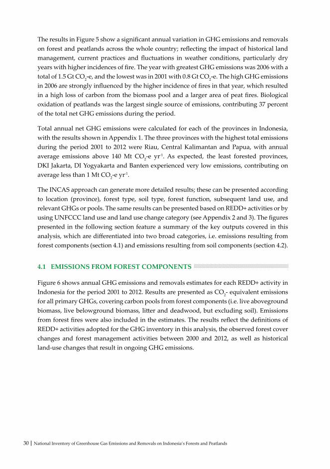
30 | National Inventory of Greenhouse Gas Emissions and Removals on Indonesia’s Forests and Peatlands
The results in Figure 5 show a significant annual variation in GHG emissions and removals on forest and peatlands across the whole country; reflecting the impact of historical land management, current practices and fluctuations in weather conditions, particularly dry years with higher incidences of fire. The year with greatest GHG emissions was 2006 with a total of 1.5 Gt CO2-e, and the lowest was in 2001 with 0.8 Gt CO2-e. The high GHG emissions in 2006 are strongly influenced by the higher incidence of fires in that year, which resulted in a high loss of carbon from the biomass pool and a larger area of peat fires. Biological oxidation of peatlands was the largest single source of emissions, contributing 37 percent of the total net GHG emissions during the period.
Total annual net GHG emissions were calculated for each of the provinces in Indonesia, with the results shown in Appendix 1. The three provinces with the highest total emissions during the period 2001 to 2012 were Riau, Central Kalimantan and Papua, with annual average emissions above 140 Mt CO2-e yr-1. As expected, the least forested provinces, DKI Jakarta, DI Yogyakarta and Banten experienced very low emissions, contributing on average less than 1 Mt CO2-e yr-1.
The INCAS approach can generate more detailed results; these can be presented according to location (province), forest type, soil type, forest function, subsequent land use, and relevant GHGs or pools. The same results can be presented based on REDD+ activities or by using UNFCCC land use and land use change category (see Appendix 2 and 3). The figures presented in the following section feature a summary of the key outputs covered in this analysis, which are differentiated into two broad categories, i.e. emissions resulting from forest components (section 4.1) and emissions resulting from soil components (section 4.2).
4.1 EMISSIONS FROM FOREST COMPONENTS
Figure 6 shows annual GHG emissions and removals estimates for each REDD+ activity in Indonesia for the period 2001 to 2012. Results are presented as CO2- equivalent emissions for all primary GHGs, covering carbon pools from forest components (i.e. live aboveground biomass, live belowground biomass, litter and deadwood, but excluding soil). Emissions from forest fires were also included in the estimates. The results reflect the definitions of REDD+ activities adopted for the GHG inventory in this analysis, the observed forest cover changes and forest management activities between 2000 and 2012, as well as historical land-use changes that result in ongoing GHG emissions.

National Inventory of Greenhouse Gas Emissions and Removals on Indonesia’s Forests and Peatlands | 31
Figure 6. Total annual net GHG emissions estimates in Indonesia (excluding soil) for the period 2001 to 2012 from REDD+ activities
The distribution of GHG emissions between each REDD+ activity (as shown in Figure 6) reflects the definitions used in the analysis. Different definitions would result in a different distribution of GHG emissions between these REDD+ activities.
Results in Figure 6 indicate that forest degradation is likely to be a significant source of GHG emissions from REDD+ activities as well as deforestation, with the annual average emissions of 367 Mt CO2-e yr-1 and 265 Mt CO2-e yr-1, respectively. Year 2006 was the year with highest GHG emissions from forest degradation with the total of 580 Mt CO2-e of GHG emissions released to the atmosphere across all of Indonesia. There is substantial fluctuation between GHG emissions from other REDD+ activities, partly reflecting the definitions used for each activity.
Net GHG emissions from lands subjected to deforestation reached a high of 330 Mt CO2-e in year 2009 and a low of 164 Mt CO2-e in year 2001. Net GHG emissions from lands subject to sustainable management of forests (SMF) range from 1.4 Mt CO2-e in year 2001 to 11.6 Mt CO2-e in year 2009. Enhancement of forest carbon stocks removed a total of 126 M t CO2-e of GHG over the period from 2001 to 2012.
-200
0
200
400
600
800
1000
2001
2002
2003
2004
2005
2006
2007
2008
2009
2010
2011
2012
Mill
ions
Year
Deforestation Enhancement of Forest C-stockForest Degradation SMF
Emis
sion
(tC
O2-e
q)

32 | National Inventory of Greenhouse Gas Emissions and Removals on Indonesia’s Forests and Peatlands
Emissions from deforestation are mainly caused by clearing activity associated with converting forest land to non-forest land (95%); intense fires also influenced deforestation events contributing 5% of the GHG emissions from deforestation (Figure 7-left). Ongoing GHG emissions from deforested land, which are required to be reported in this land use change category for 20 years after the initial land-use change activity (IPCC, 2006), also strongly influence emissions from deforestation. This leads to a much larger area of land contributing to deforestation GHG emissions than the annual deforestation area shown in Table 3.
High emissions from forest degradation is likely to be caused by conventional logging (62%) and fires (38%) (Figure 7-right). Degradation often creates fragmented forests that are more susceptible to further degradation. Although regrowth will have a significant offsetting effect, change in forest structure and species composition due to conventional logging and fires may result in long-term loss of carbon from biomass and dead organic matter pools and sustained increase in emissions of non-CO2 GHG from fires.
95%
5%
Clearing
Fire
38%
62%
Fire
Logging
Figure 7. Events causing emissions from deforestation (left) and forest degradation (right)
Deforestation events mainly occurred in production forests, especially in convertible production forest, and forested land allocated for other uses, known as APL (areal penggunaan lain), which account for 44% and 43% GHG emissions from deforestation event, respectively (Figure 8-left). Deforestation was also detected in conservation and protection forests (13%), which is mainly caused by clearing due to illegal logging and encroachment activities. Forest degradation, as expected, occurs mainly in production forests (66%) (Figure 8-right) due to conventional logging and fires. Forest degradation was also detected in conservation and protection forests (20%) and APL* (15%), which are both caused by illegal logging and fires.

National Inventory of Greenhouse Gas Emissions and Removals on Indonesia’s Forests and Peatlands | 33
43%
13%
44%
APL*
Conservation& Protection
Production
15%
20%
66%
APL*
Conservation& Protection
Production
Figure 8. The occurence of deforestation (left) and forest degradation (right) events by forest function
4.2 EMISSIONS FROM SOILS
4.2.1 Emissions from Peat (Organic Soils)
As shown earlier in Figure 5, generally GHG emissions from the biological oxidation of peatlands were the largest source of emissions. Figure 9 presents the annual estimates of GHG emissions from peat biological oxidation in Indonesia for the period 2001 to 2012. This figure includes direct N2O, dissolved organic carbon (DOC) and CH4 emissions from disturbed peatland. GHG emissions from disturbed peatland gradually increase from about 307 MtCO2e in 2001 to about 335 MtCO2e in 2012. The high peatland GHG emissions result from the large areas of peatlands that were cleared and subsequently drained in the years prior to the analysis period, hence making these areas highly susceptible to oxidation. Riau, Central Kalimantan and Papua provinces contributed to more than 60% of the total GHG emissions from disturbed peatland in Indonesia.

34 | National Inventory of Greenhouse Gas Emissions and Removals on Indonesia’s Forests and Peatlands
Figure 9. Total annual GHG emissions estimates in Indonesia from peat biological oxidation for the period 2001 to 2012
In addition to peat biological oxidation, peat fires also contributed to the total GHG emissions from forest and peatlands in Indonesia (Figure 5). Figure 10 presents the annual estimates of GHG emissions from peat fires in Indonesia for the period 2001 to 2012. This figure includes CO2 emissions and non-CO2 emissions (CH4) from peat fires. Annual GHG emissions from peat fires varied substantially during the period 2001 to 2012 (Figure 10). The highest occurrence of peat fires was found in 2002 and 2006 that account for 180 MtCO2e and 183 MtCO2e, respectively; while the lowest occurrence was found in 2010 that accounts for 15 MtCO2e. The high increase in emissions from peat fires in 2006 and then again in 2009 strongly contributed to the elevated total emissions from peatland in those years. Riau, Central Kalimantan and South Sumatra are three provinces in Indonesia with high incidence of peat fires throughout the years, which contributed to more than 70% of the total GHG emissions from peat fires in Indonesia.
0
50
100
150
200
250
300
350
400
2001
2002
2003
2004
2005
2006
2007
2008
2009
2010
2011
2012
Mill
ions
Year
CO2 N2O CH4 DOC
Emis
sion
(tC
O2-e
q)

National Inventory of Greenhouse Gas Emissions and Removals on Indonesia’s Forests and Peatlands | 35
0
20
40
60
80
100
120
140
160
180
200
2001
2002
2003
2004
2005
2006
2007
2008
2009
2010
2011
2012
Mill
ions
Year
CO2 CH4
Emis
sion
(tC
O2-e
q)
Figure 10. Annual GHG emissions estimates in Indonesia from peat fires for the period 2001 to 2012
4.2.2 Emissions from Mineral Soils
Figure 11 shows the total annual GHG emissions in tonnes CO2-e resulting from the soil organic carbon pool on mineral soil subject to change from forest to non-forest. This figure includes CO2 emissions and non-CO2 emissions (N2O) from mineral soil. Emissions from mineral soils increase gradually from 45 Mt CO2-e in 2001 to 59 Mt CO2-e in 2010. The increase in emissions is a function of increasing cumulative area affected as more area of mineral soils is exposed through deforestation. The emissions presented here include emissions from the areas deforested during the simulation period as well as the areas deforested prior to 2000. The area affected increases each year, with constant emissions occurring each year once events occur on forest lands (i.e. the increase in emissions is a function of increasing cumulative area affected).

36 | National Inventory of Greenhouse Gas Emissions and Removals on Indonesia’s Forests and Peatlands
Figure 11. Annual GHG emissions estimates in Indonesia from mineral soils for the period 2001 to 2012
0
10
20
30
40
50
60
70
2001
2002
2003
2004
2005
2006
2007
2008
2009
2010
2011
2012
Mill
ions
Year
N2O CO2
Emis
sion
(tC
O2-e
q)

National Inventory of Greenhouse Gas Emissions and Removals on Indonesia’s Forests and Peatlands | 37
DISCUSSION
The INCAS results presented in this document provide the most comprehensive account of annual GHG emissions and removals from forests and peatlands in Indonesia to date. This is also the first time that national results of net GHG emissions and removals have been generated and presented for each of the key REDD+ activities in Indonesia. This level of detail provides credible information to empower the Government of Indonesia to make informed decisions about the management of emissions and design mitigation actions that meet other national needs, including for land use planning purposes. This is a substantial advancement over the simple activity data multiplied by emissions factor approach, which has significant limitations for practical application in REDD+ monitoring.
The level of detail available from this GHG inventory enables reporting to meet a wide range of requirements. For example, for the first time it is possible to break down the national deforestation emissions profile into its constituent elements of forest carbon stock change, non-CO2 emissions from biomass burning, CO2 and non-CO2 emissions from mineral soil, biological oxidation, direct N2O, DOC and CH4 emissions from disturbed peat, and CO2 and non-CO2 emissions from peat fire. This enables reporting of all GHGs required by the UNFCCC’s National Communications and Biennial Update Reports. It also allows for emissions reduction efforts to be targeted to deliver efficient and effective results.
The INCAS approach also enables more detailed analysis of the sources of GHG emissions from forests and peatlands in Indonesia. Emissions and removals can be broken down by province, UNFCCC land use category, forest type, forest function, broad soil type and REDD+ activity. This level of detail provides a sound basis for establishing Indonesia’s Forest Reference Emission Level or Forest Reference Level in a way that makes it possible to assess future REDD+ performance, and also provides the detail needed to target emissions reduction efforts to deliver efficient and effective results.
The capability built into the INCAS framework allows for dynamic input of data, as demonstrated in this document, enabling production of GHG emissions and removal estimates with greater certainty. This provides Indonesia with the opportunity to roll out a transparent, accurate, complete, consistent and comparable system for use at the national, provincial, district and project level.

38 | National Inventory of Greenhouse Gas Emissions and Removals on Indonesia’s Forests and Peatlands
The flexibility of the INCAS framework effectively enabled data of varying levels of detail to be incorporated into the GHG inventory. As available data improves, this can be used to update input data, and enable the inventory to be rerun to produce further improved GHG emissions and removals estimates.
Detailed provincial level results from this national inventory have been incorporated into a searchable results database that will enable Government of Indonesia officials to further analyze trends in emissions and removals, and the underlying data. This could be used to identify data limitations or gaps and guide further data collection and research priorities.
Further analysis of the results presented in this document is recommended to assist Indonesian policy-makers to understand historical trends in greenhouse gas emissions and their sources. This would be of even greater value if combined with an analysis of changes in land use and management policies at the national and provincial level from 1990 to the present. The combination of historical policy settings and historical greenhouse gas emissions and removals would provide a powerful basis for assessing the impact and effectiveness of policy development and implementation.

National Inventory of Greenhouse Gas Emissions and Removals on Indonesia’s Forests and Peatlands | 39
Continuous improvement is a fundamental principle of the INCAS approach. The INCAS framework and standard methods were trialed over the REDD+ Pilot Province of Central Kalimantan, with the methods and results published in February 2015 (Krisnawati et al., 2015a; 2015b). These publications identified opportunities for improvement in data and methods to further reduce uncertainties in GHG emissions and removals estimates for forests and peatlands in Indonesia.
With this in mind the Government of Indonesia elected to base the national level analysis of INCAS on the same methods used for Central Kalimantan pilot account, with improvements where possible. Limitations and opportunities for improvement have been progressively documented as input data has been collated, and as quantification of GHG emissions and removals has been undertaken and quality assurance completed. The methods and data sources reported in this document at the national level represent incremental improvement over those for the Pilot Province.
Further development of INCAS is planned and documented in the four-year INCAS Roadmap (MOEF, 2015) with the goal of incorporating all land sector activities and further reducing uncertainties in GHG emissions and removals estimates in future national inventories.
The system framework is flexible enough to incorporate these improvements without significant changes. Recommended improvements are outlined below:
• More data sets should be incorporated. Indonesia has a lot of data that can be used to further improve GHG emissions and removals estimates. All potentially available data sets should be reviewed to identify additional data that could be used to improve GHG emissions and removals estimates. Following review, data would need to be transformed into formats suitable for use by the INCAS framework, for example as demonstrated in the Standard Method – Initial Conditions and Standard Method – Forest Growth and Turnover (Annex).
IMPROVEMENT PLAN

40 | National Inventory of Greenhouse Gas Emissions and Removals on Indonesia’s Forests and Peatlands
• Attribution and forest type mapping should be improved. The detailed spatial analysis of annual forest cover change available from LAPAN (2014) combined with spatial data about forest types and management practices available at MoEF have greatly improved the identification of forest change events. This can be further improved by greater collaboration between forest cover mapping and spatial analysis processes.
• The length of the time series of forest cover change should be increased. Results would be enhanced through a more detailed understanding of land management events prior to 2000, as this influences the estimation of forest biomass and debris, and the degree of peat degradation during the period 2001 to 2012. This could be achieved by extending the annual forest cover change analysis to at least 1990, and extracting more detailed information from historical land management records (for example, current available data for the 1990s has been limited to two time points, 1990 and 1996, but these could not capture annual forest cover change between the two points with a longer time of interval). LAPAN is currently undertaking forest cover change analysis for years 2013 and 2014.
• The INCAS work program should be internalized into the daily activities of GOI land management agencies. Institutionalization and adequate resourcing of the INCAS work program will broaden the knowledge base and data upon which this analysis relies. This will enable more accurate estimates of GHG emissions and removals estimates for land-use changes from forest to other land uses. For example, greater detail about how land is managed after deforestation will provide greater certainty about the deforestation account, because once deforested, emissions and removals of subsequent land uses are included in the account, and can significantly contribute to ongoing annual emissions, particularly on peat land. The inclusion of agricultural land management data would significantly improve emissions estimates.
• Fire maps should be improved. The burnt area analysis for the national GHG inventory reported in this document relied on the relationship model developed from the study of peat fires in Central Kalimantan. Additional analysis should be undertaken for other regions in Indonesia to improve the spatial accuracy of data about historical fire areas and fire intensity.
• Improved emission estimates for peat should be generated. Scientific conjecture exists about the most appropriate peat emission factors to be used. Further analysis of relationships between specific peatland management events and emissions would greatly contribute to generating peatland emissions estimates at the same level as currently possible for forest biomass emissions and removals estimates. Greater detail about the rate of peat biological emissions in the first five years following drainage is needed to provide more accurate estimates of the impact of these operations on GHG emissions. This will be important to gaining a clearer picture of historical emissions needed to set a realistic FREL/FRL, and to forecast the emissions impact of potential future drainage of peatlands in Indonesia.

National Inventory of Greenhouse Gas Emissions and Removals on Indonesia’s Forests and Peatlands | 41
• Improved peat maps should be used. There are known inaccuracies and missing peat depth data in current peat maps. Improved mapping of the extent and depth of peat should be incorporated as they become available.
• There should be improved understanding of emissions from peatland drainage ditches, which is not included in this analysis. IPCC 2013 EFs for emissions from tropical drainage ditches are based on a limited number of studies. Improved data on drainage ditch emissions and the locations and surface area of drainage ditches are required to enable drainage ditch emissions to be included for all of Indonesia.
• QA/QC processes should be more formalized. Comprehensive QA/QC for all phases of the analytical process including data inputs and results should be formalized to ensure consistency of processes across the country. Validation of any new analysis tools or model components should be undertaken.
• INCAS should transition to using full spatial modeling. The INCAS framework is designed to utilize fully spatial integration between forest cover change mapping, biophysical conditions and GHG emissions modeling. INCAS should explore opportunities to become involved in international efforts to more efficiently manage and integrate the large data sets required for full spatial modeling.
The capability developed within the INCAS team and planned collaboration with other countries presents opportunities for Indonesia to participate in the development and trialing of the next generation of Tier 3 tools for national GHG inventories. This will place Indonesia at the forefront of efforts to more accurately monitor and report GHG emissions and removals from the land-based sectors.

42 | National Inventory of Greenhouse Gas Emissions and Removals on Indonesia’s Forests and Peatlands
Agus, F., Hairiah, K. and Mulyani, A. 2011. Measuring Carbon Stock in Peat Soil: Practical Guidelines. Bogor: World Agroforestry Centre (ICRAF) and Indonesian Soil Research Institute. Available from http://balittanah.litbang.deptan.go.id
Ballhorn,U., Navratil, P. and Siegert. F. 2014. Generation of Spatial Burned Area Data of the Central Kalimantan Province for the Indonesian National Carbon Accounting System (INCAS), Final Report Draft, June 2014, prepared for the Indonesia-Australia Forest Carbon Partnership. IAFCP, Jakarta.
National Standardization Agency. 2013. SNI 7925: Pemetaan Lahan Gambut skala 1:50.000 berbasis Citra Penginderaan Jauh. BSN, Jakarta.
National Standardization Agency. 2014. SNI 8033: Metode Penghitungan Perubahan Tutupan Hutan Berdasarkan Hasil Penafsiran Citra Penginderaan Jauh Optik Secara Visual. BSN, Jakarta.
Dykstra, D.P. 2008. Reduced impact logging: concepts and issue. In: Enters, T., Durst, P.B., Applegate, G.B., Kho, P.C.S. and Man, G. (Eds.). Applying Reduced Impact Logging to Advance Sustainable Forest Management . Rome(IT): FAO. p 23-40.
[FAO] Food and Agriculture Organization of the United Nations. 2001. Global Forest Resources Assessment 2000. FAO, Rome.
[FAO] Food and Agriculture Organization of the United Nations. 2010. Global Forest Resources Assessment 2010. FAO, Rome.
[GFOI] Global Forest Observations Initiative. 2013. Integrating remote-sensing and ground based observations for estimation of emissions and removals of greenhouse gases in forests: Methods and guidance from the Global Forest Observations Initiative. Group on Earth Observations, Geneva.
Hooijer, A. S. Page, P. Navratil, R. Vernimmen, M. Van der Vat, K. Tansey, K. Konecny, F. Siegert, U. Ballhorn and N. Mawdsley. 2014. Carbon emissions from drained and degraded peat land in Indonesia and emission factors for measurement, reporting and verification (MRV) of peat land greenhouse gas emissions - summary of KFCP research results for practitioners. IAFCP, Jakarta.
REFERENCES

National Inventory of Greenhouse Gas Emissions and Removals on Indonesia’s Forests and Peatlands | 43
[IPCC] Intergovernmental Panel on Climate Change. 2013. 2013 Supplement to the 2006 IPPC guidelines for national greenhouse gas inventories: Wetlands. Methodological guidance on lands with wet and drained soils, and constructed wetlands for wastewater treatment. Gyldenkaerne, S. and Lin, E. (eds). Japan: Institute for Global Environmental Strategies [IGES].
[IPCC] Intergovernmental Panel on Climate Change. 2006. IPCC guidelines for national greenhouse gas inventories. National Greenhouse Gas Inventories Programme. Eggleston, H.S., Buendia, L., Miwa, K., Ngara, T. and Tanabe, K. (eds). Japan: Institute for Global Environmental Strategies [IGES].
[IPCC] Intergovernmental Panel on Climate Change. 2003. Good practice guidance for land use, land use change and forestry. National Greenhouse Gas Inventories Programme. Penman, J., Gytarsky, M., Hiraishi, T., Krug, T., Kruger, D., Pipatti, R., Buendia, L., Miwa, K., Ngara, T., Tanabe, K. (eds). Japan: Institute for Global Environmental Strategies [IGES].
Krisnawati, H., Imanuddin, R., Adinugroho, W.C. and Hutabarat, S. 2015a. Standard Methods for Estimating Greenhouse Gas Emissions from the Forestry Sector in Indonesia, Version 1. Research and Development Center for Conservation and Rehabilitation, Forestry Research and Development Agency, Bogor, Indonesia.
Krisnawati, H., Adinugroho, W.C., Imanuddin, R. and Hutabarat, S. 2015b. Estimation of Annual Greenhouse Gas Emissions from Forest and Peatlands in Central Kalimantan. Forestry Research and Development Agency, Bogor.
[LAPAN] Lembaga Penerbangan dan Antariksa Nasional. 2014. The Remote Sensing Monitoring Program of Indonesia’s National Carbon Accounting System: Methodology and Products, Version 1. LAPAN–IAFCP, Jakarta.
Margono, B.A., Potapov, P.V., Turubanova, S., Stolle, F. & Hansen, C.M. (2014). Primary forest cover loss in Indonesia over 2000–2012. Nature Climate Change 4, 730–735.
[MOEF] Ministry of Environment and Forestry. 2015. INCAS Roadmap: Guiding the development and operation of Indonesia’s national MRV platform for the land-based sectors. Research, Development and Innovation Agency, Bogor.
[MOF] Ministry of Forestry. 2009. Peraturan Menteri Kehutanan Republik Indonesia No. P.30/Menhut-II/2009. Tata Cara Pengurangan Emisi dari Deforestasi dan Degradasi Hutan (REDD).
[MOF] Ministry of Forestry. 2004. Peraturan Menteri Kehutanan Republik Indonesia No. P.14/Menhut-II/2004. Tata Cara Aforestasi dan Reforestasi dalam Kerangka Mekanisme Pembangunan Bersih.

44 | National Inventory of Greenhouse Gas Emissions and Removals on Indonesia’s Forests and Peatlands
Page, S., Tansey, K., Navratil, P., Hooijer, A. and Mawdsley, N. 2014. Measuring Emissions from Peat Fire: Commentary on a Proposed Methodology for Indonesia. Draft Report, prepared for the Indonesia-Australia Forest Carbon Partnership. IAFCP, Jakarta.
Ritung S., Wahyunto, Nugroho K., Sukarman, Hikmatullah, Suparto, C. T. (2011). Peta lahan gambut indonesia Skala 1:250.000 (p. 11). Kementerian Pertanian, Jakarta.
Romijn E., Herbert A. J., Wijaya A., Herold M., Angelsen A., Verchot L., Murdiyarso D. (2013). Exploring different forest definitions and their impact on developing REDD+ reference emission levels: a case study for Indonesia. Environmental Science and Policy, 33, 246-259.
State Ministry of Environment. 2010. Indonesia Second National Communication under the United Nations Framework Convention on Climate Change (UNFCCC). State Ministry of Environment, Jakarta.
Thompson, I. D., M. R. Guariguata, K. Okabe, C. Bahamondez, R. Nasi, V. Heymell, and C. Sabogal (2013). An operational framework for defining and monitoring forest degradation. Ecology and Society 18 (2): 20.
Wahyunto, S., Ritung and Subagjo, H. 2004. Map of Peat land Distribution Area and Carbon Content in Kalimantan, 2000 – 2002. Wetlands International - Indonesia Programme & Wildlife Habitat Canada (WHC).

National Inventory of Greenhouse Gas Emissions and Removals on Indonesia’s Forests and Peatlands | 45
App
endi
x 1.
Tot
al a
nnua
l net
GH
G em
issio
ns es
timat
es b
y pr
ovin
ce in
Indo
nesia
for t
he p
erio
d 20
01 to
201
2
No
Prov
ince
TOTA
L EM
ISSI
ON
(mill
ion
t CO
2-eq)
Tota
l (2
001-
2012
)
Ave
rage
(2
001-
2012
)20
0120
0220
0320
0420
0520
0620
0720
0820
0920
1020
1120
12
TOTA
L (I
ndon
esia
)76
8.43
1
,291
.39
1,11
5.36
1
,212
.80
1,12
8.57
1
,465
.96
1,02
5.72
1,
037.
88
1,2
19.3
4 86
8.24
92
5.42
8
62.1
3 12
,921
.25
1,07
6.77
1RI
AU
117.
50
162
.91
168
.33
179
.53
249
.63
226
.85
153
.85
173.
03
186
.46
143.
06
144.
96
147
.75
2,05
3.85
1
71.1
5
2K
ALI
MA
NTA
N T
ENG
AH
102.
90
218
.43
158
.67
183
.03
150
.13
277
.54
165
.15
130.
82
176
.53
97.
22
114.
78
121
.73
1,89
6.93
1
58.0
8
3PA
PUA
119.
20
145
.93
137
.95
161
.00
142
.23
154
.31
157
.64
158.
49
164
.09
124.
98
120.
27
114
.61
1,70
0.69
1
41.7
2
4K
ALI
MA
NTA
N B
ARA
T 5
0.72
1
01.4
7 7
5.55
9
0.31
7
8.11
1
30.3
2 9
0.87
10
2.32
1
53.9
5 8
9.47
10
6.83
9
8.91
1,
168.
86
97.
40
5PA
PUA
BA
RAT
56.
58
74.
01
71.
14
59.
90
56.
90
57.
97
55.
11
55.
50
55.
92
55.
89
48.
70
44.
33
691
.95
57.
66
6K
ALI
MA
NTA
N T
IMU
R 5
7.56
7
8.94
7
8.58
6
8.95
5
7.47
6
6.23
4
7.58
4
4.05
5
8.01
3
6.47
4
2.39
3
9.84
6
76.0
6 5
6.34
7JA
MBI
32.
58
46.
84
52.
53
59.
98
46.
97
64.
71
58.
16
60.
98
58.
51
32.
14
42.
30
40.
32
596
.02
49.
67
8SU
MA
TERA
SEL
ATA
N 2
8.61
6
1.40
3
1.20
4
6.74
2
4.74
8
5.53
3
0.51
2
5.36
3
9.61
3
0.58
5
0.34
5
0.76
5
05.3
7 4
2.11
9SU
LAW
ESI T
ENG
AH
27.
33
49.
65
39.
82
38.
24
32.
79
40.
99
26.
96
28.
30
32.
14
36.
17
36.
31
20.
72
409
.43
34.
12
10K
ALI
MA
NTA
N U
TARA
24.
56
39.
12
48.
17
36.
27
32.
93
31.
06
25.
06
24.
63
28.
90
20.
77
22.
20
20.
85
354
.52
29.
54
11SU
LAW
ESI T
ENG
GA
RA 8
.08
22.
32
15.
85
49.
42
48.
88
59.
32
23.
53
19.
23
18.
65
10.
67
13.
85
8.0
2 2
97.8
1 2
4.82
12N
TT 8
.21
33.
41
18.
77
23.
44
18.
11
26.
58
18.
29
21.
65
30.
14
41.
36
34.
37
18.
99
293
.32
24.
44
13K
ALI
MA
NTA
N S
ELA
TAN
25.
06
42.
34
34.
60
28.
90
23.
13
31.
75
16.
75
14.
61
23.
00
13.
61
16.
89
12.
82
283
.47
23.
62
14SU
MA
TERA
UTA
RA 1
7.60
2
0.92
2
0.74
2
4.44
2
6.89
2
8.35
2
1.25
2
6.99
3
1.21
1
8.69
1
8.97
1
6.01
2
72.0
4 2
2.67
15JA
WA
TIM
UR
4.9
0 2
4.21
2
3.56
2
0.53
1
7.72
2
4.23
2
6.51
2
7.80
3
0.08
9
.86
11.
39
11.
39
232
.18
19.
35
16A
CEH
13.
84
17.
83
16.
11
16.
36
16.
02
18.
44
15.
85
24.
39
26.
95
16.
56
17.
44
15.
16
214
.94
17.
91
17SU
MA
TERA
BA
RAT
10.
32
14.
48
17.
20
17.
69
17.
83
27.
38
15.
55
20.
67
17.
82
10.
40
11.
23
11.
81
192
.38
16.
03
APP
END
IX

46 | National Inventory of Greenhouse Gas Emissions and Removals on Indonesia’s Forests and Peatlands
No
Prov
ince
TOTA
L EM
ISSI
ON
(mill
ion
t CO
2-eq)
Tota
l (2
001-
2012
)
Ave
rage
(2
001-
2012
)20
0120
0220
0320
0420
0520
0620
0720
0820
0920
1020
1120
12
18M
ALU
KU
UTA
RA 9
.06
16.
97
11.
35
19.
00
18.
68
21.
25
11.
15
11.
82
13.
73
17.
60
13.
12
11.
74
175
.46
14.
62
19SU
LAW
ESI S
ELA
TAN
11.
51
25.
43
19.
33
16.
04
12.
26
12.
95
10.
88
13.
20
12.
04
8.7
9 7
.07
5.5
1 1
55.0
2 1
2.92
20SU
LAW
ESI B
ARA
T 7
.50
20.
29
16.
87
15.
36
11.
14
11.
57
9.8
4 9
.42
11.
33
7.1
4 8
.50
5.5
7 1
34.5
2 1
1.21
21M
ALU
KU
4.8
9 1
2.57
7
.59
7.9
1 6
.36
9.8
7 7
.55
8.6
5 1
1.49
1
1.58
9
.61
9.1
0 1
07.1
8 8
.93
22N
TB 4
.55
11.
59
8.4
3 7
.97
5.6
4 5
.56
7.0
3 7
.63
8.3
8 5
.97
5.7
8 1
1.18
8
9.71
7
.48
23JA
WA
TEN
GA
H 2
.84
9.8
8 8
.79
7.7
4 5
.46
10.
31
6.2
7 6
.04
5.1
3 4
.86
5.7
5 3
.43
76.
50
6.3
7
24BE
NG
KU
LU 5
.32
6.7
4 7
.68
7.3
2 5
.46
6.4
3 5
.39
6.0
7 6
.09
5.5
4 6
.40
3.7
9 7
2.22
6
.02
25G
ORO
NTA
LO 5
.80
10.
71
8.2
6 5
.10
5.1
7 5
.68
3.9
8 3
.47
3.5
5 2
.27
1.9
4 1
.90
57.
84
4.8
2
26BA
NG
KA
BEL
ITU
NG
2.3
2 4
.58
4.2
7 4
.91
3.3
9 7
.17
3.7
4 5
.13
6.4
3 2
.47
3.2
2 4
.81
52.
44
4.3
7
27SU
LAW
ESI U
TARA
3.6
7 7
.02
4.6
1 5
.50
5.3
4 5
.94
3.4
9 2
.84
2.5
9 2
.17
1.8
4 1
.78
46.
79
3.9
0
28LA
MPU
NG
2.3
7 5
.45
3.4
1 3
.60
2.0
7 7
.89
2.9
0 2
.35
3.1
8 4
.17
5.1
6 3
.82
46.
36
3.8
6
29JA
WA
BA
RAT
1.2
3 3
.33
3.9
4 5
.40
4.8
8 6
.90
2.1
7 0
.67
1.2
3 6
.27
2.3
8 3
.61
42.
01
3.5
0
30K
EPU
LAU
AN
RIA
U 1
.26
1.2
9 1
.31
1.6
7 1
.94
1.8
6 2
.04
1.3
2 1
.96
1.2
1 0
.93
1.3
0 1
8.09
1
.51
31BA
LI 0
.30
0.3
4 0
.22
0.2
9 0
.28
0.3
5 0
.25
0.1
8 0
.23
0.1
6 0
.23
0.3
8 3
.21
0.2
7
32BA
NTE
N 0
.15
0.4
6 0
.40
0.1
5 (0
.07)
0.5
9 0
.39
0.2
6 0
.01
0.0
5 0
.18
0.2
1 2
.79
0.2
3
33D
I YO
GYA
KA
RTA
0.1
0 0
.51
0.1
2 0
.09
0.0
8 0
.08
0.0
3 0
.01
0.0
3 0
.08
0.1
2 0
.02
1.2
9 0
.11
34D
KI J
AK
ART
A 0
.00
0.0
0 0
.00
0.0
0 0
.00
0.0
0 0
.00
0.0
0 0
.00
0.0
0 0
.00
0.0
0 0
.00
0.0
0

National Inventory of Greenhouse Gas Emissions and Removals on Indonesia’s Forests and Peatlands | 47
App
endi
x 2.
Net
tota
l GH
G em
issio
ns b
y U
NFC
CC la
nd-u
se ca
tego
ry -
Fore
st la
nd
GR
EEN
HO
USE
GA
S SO
UR
CE
AN
D S
INK
CA
TEG
OR
IES
Land
-use
ca
tego
ry
Car
bon
Stoc
k C
hang
e/N
et
CO
2 em
issi
ons/
rem
oval
s
2001
2002
2003
2004
2005
2006
2007
2008
2009
2010
2011
2012
A. T
otal
fo
rest
land
Are
a (h
a) 1,
204,
994
2,01
1,69
9 1,
656,
099
1,99
5,20
2 1,
803,
141
2,45
6,12
2 1,
560,
372
1,5
54,6
32
2,0
14,3
39
1,07
6,95
1 1,
300,
978
1,29
1,29
7
Net
car
bon
stoc
k ch
ange
in li
ving
bi
omas
s(th
ousa
nd t
C)
(51,
561)
(9
6,49
7)
(71,
394)
(8
6,85
4)
(67,
945)
(1
00,1
59)
(40,
855)
(3
5,12
1)
(55,
730)
1
,253
(14,
038)
(1
5,30
2)
Net
car
bon
stoc
k ch
ange
in d
ead
orga
nic
matt
er
(thou
sand
t C
)
(7,1
65)
(39,
109)
(3
7,37
4)
(41,
244)
(4
1,98
2)
(47,
006)
(4
5,93
2)
(45,
807)
(5
0,37
0)
(50,
870)
(4
9,12
4)
(48,
046)
Net
car
bon
stoc
k ch
ange
in
min
eral
soi
ls
(thou
sand
t C
)21
- -
- -
- -
- -
- -
- -
Net
car
bon
stoc
k ch
ange
in
org
anic
soi
ls
(thou
sand
t C
)
(40,
831)
(4
1,11
1)
(41,
363)
(4
2,07
7)
(42,
930)
(4
3,59
6)
(44,
023)
(4
4,60
3)
(45,
388)
(4
5,97
2)
(46,
770)
(4
7,38
1)
Net
em
issi
ons/
rem
oval
s(th
ousa
nd t
CO
2) 3
65,0
43
647
,961
5
50,4
81
623
,977
5
60,4
76
699,
461
479
,636
4
60,2
76
555
,455
3
50,4
94
403
,083
4
06,0
08
21 U
nder
Tie
r 1, i
t is a
ssum
ed th
at w
hen
fore
st re
mai
ns fo
rest
the
carb
on st
ock
in so
il or
gani
c matt
er d
oes n
ot ch
ange
, reg
ardl
ess o
f cha
nges
in fo
rest
man
agem
ent,
type
s, a
nd d
istu
rban
ce re
gim
es.
In o
ther
wor
ds th
e ca
rbon
sto
ck in
min
eral
soi
l rem
ains
con
stan
t so
long
as
the
land
rem
ains
fore
st (I
PCC
, 200
3).

48 | National Inventory of Greenhouse Gas Emissions and Removals on Indonesia’s Forests and Peatlands
GR
EEN
HO
USE
GA
S SO
UR
CE
AN
D S
INK
CA
TEG
OR
IES
Land
-use
ca
tego
ry
Car
bon
Stoc
k C
hang
e/N
et
CO
2 em
issi
ons/
rem
oval
s
2001
2002
2003
2004
2005
2006
2007
2008
2009
2010
2011
2012
1. F
ores
t la
nd
rem
aini
ng
fore
st la
nd
Are
a (h
a) 1,
081,
146
1,87
4,03
3 1,
534,
485
1,89
3,44
6 1,
710,
951
2,36
4,04
7 1,
460,
766
1,4
54,2
48
1,8
98,4
12
934
,547
1,
223,
885
1,25
5,70
1
Net
car
bon
stoc
k ch
ange
in li
ving
bi
omas
s(th
ousa
nd t
C)
(52,
017)
(9
7,35
5)
(72,
631)
(8
8,47
4)
(69,
970)
(1
02,6
26)
(43,
834)
(3
8,63
0)
(59,
793)
(3
,512
) (1
9,24
0)
(20,
794)
Net
car
bon
stoc
k ch
ange
in d
ead
orga
nic
matt
er
(thou
sand
t C
)
(7,1
49)
(39,
086)
(3
7,34
5)
(41,
221)
(4
1,95
3)
(46,
980)
(4
5,89
3)
(45,
755)
(5
0,31
7)
(50,
820)
(4
9,10
3)
(48,
054)
Net
car
bon
stoc
k ch
ange
in
min
eral
soi
ls
(thou
sand
t C
)
- -
- -
- -
- -
- -
- -
Net
car
bon
stoc
k ch
ange
in
org
anic
soi
ls
(thou
sand
t C
)
(40,
831)
(4
1,11
1)
(41,
363)
(4
2,07
7)
(42,
930)
(4
3,59
6)
(44,
023)
(4
4,60
3)
(45,
388)
(4
5,97
2)
(46,
770)
(4
7,38
1)
Net
em
issi
ons/
re
mov
als
(thou
sand
t C
O2)
366
,658
6
51,0
22
554
,910
6
29,8
32
567
,797
708
,408
490
,417
472
,952
570
,160
3
67,7
82
422
,081
4
26,1
75

National Inventory of Greenhouse Gas Emissions and Removals on Indonesia’s Forests and Peatlands | 49
GR
EEN
HO
USE
GA
S SO
UR
CE
AN
D S
INK
CA
TEG
OR
IES
Land
-use
ca
tego
ry
Car
bon
Stoc
k C
hang
e/N
et
CO
2 em
issi
ons/
rem
oval
s
2001
2002
2003
2004
2005
2006
2007
2008
2009
2010
2011
2012
2. L
and
conv
erte
d to
fore
st
land
Are
a (h
a) 1
23,8
48
137
,666
1
21,6
14
101
,756
9
2,19
0 9
2,07
5 9
9,60
6 1
00,3
85
115
,927
1
42,4
04
77,
093
35,
595
Net
car
bon
stoc
k ch
ange
in li
ving
bi
omas
s(th
ousa
nd t
C)
457
858
1,2
37 1
,619
2,0
25 2
,466
2,9
79 3
,509
4,0
63 4
,765
5,2
02 5
,492
Net
car
bon
stoc
k ch
ange
in d
ead
orga
nic
matt
er
(thou
sand
t C
)
(16)
(2
3)
(29)
(2
2)
(29)
(2
6)
(38)
(5
2)
(53)
(5
0)
(21)
8
Net
car
bon
stoc
k ch
ange
in
min
eral
soi
ls
(thou
sand
t C
)
- -
- -
- -
- -
- -
- -
Net
car
bon
stoc
k ch
ange
in
org
anic
soi
ls
(thou
sand
t C
)
- -
- -
- -
- -
- -
- -
Net
em
issi
ons/
rem
oval
s(th
ousa
nd t
CO
2) (1
,615
) (3
,062
) (4
,430
) (5
,855
) (7
,321
) (8
,947
) (1
0,78
1) (1
2,67
5) (1
4,70
6) (1
7,28
8) (1
8,99
8) (2
0,16
6)

50 | National Inventory of Greenhouse Gas Emissions and Removals on Indonesia’s Forests and Peatlands
App
endi
x 3.
Net
tota
l GH
G em
issio
ns b
y U
NFC
CC la
nd-u
se ca
tego
ry -
Crop
land
GR
EEN
HO
USE
GA
S SO
UR
CE
AN
D S
INK
CA
TEG
OR
IES
Land
-use
ca
tego
ry
Car
bon
Stoc
k C
hang
e/N
et
CO
2 em
issi
ons/
rem
oval
s
2001
2002
2003
2004
2005
2006
2007
2008
2009
2010
2011
2012
2.1
Fore
st
land
co
nver
ted
to
crop
land
Are
a (h
a) 5
8,64
3 2
38,4
58
374
,438
3
43,7
62
364
,144
4
95,4
32
467
,043
5
18,3
83
512
,816
4
24,3
60
334
,313
2
15,7
31
Net
car
bon
stoc
k ch
ange
in li
ving
bi
omas
s (th
ousa
nd t
C)
(7,3
97)
(30,
498)
(47,
380)
(4
3,84
8)
(46,
226)
(6
5,88
7)
(57,
750)
(6
4,90
5)
(65,
212)
(5
3,21
2)
(41,
722)
(2
4,99
0)
Net
car
bon
stoc
k ch
ange
in d
ead
orga
nic
matt
er
(thou
sand
t C
)
(37,
408)
(3
3,15
3)
(29,
076)
(2
6,88
0)
(25,
094)
(2
4,67
0)
(23,
615)
(2
3,30
4)
(23,
800)
(2
2,64
4)
(21,
618)
(1
9,93
6)
Net
car
bon
stoc
k ch
ange
in m
iner
al
soils
(th
ousa
nd t
C)
(11,
181)
(1
1,40
0)
(11,
732)
(1
2,06
5)
(12,
392)
(1
2,81
2)
(13,
232)
(1
3,72
4)
(14,
232)
(1
4,70
8)
(14,
588)
(1
4,33
1)
Net
car
bon
stoc
k ch
ange
in o
rgan
ic
soils
(tho
usan
d t C
) (3
2,73
8)
(62,
470)
(3
8,67
8)
(45,
763)
(4
1,78
8)
(63,
251)
(3
0,78
5)
(31,
327)
(4
5,15
0)
(29,
253)
(3
7,86
0)
(37,
581)
Net
em
issi
ons/
rem
oval
s (th
ousa
nd t
CO
2) 3
25,3
23 5
04,2
43 4
65,1
75 4
71,3
68
460
,169
6
10,9
39
459
,734
488
,621
5
44,1
14 4
39,3
27 4
24,5
56
355
,072


ISBN 978-979-8452-64-2
9 789798 452642
This publication presents the first national level results from the Indonesian National Carbon Accounting System (INCAS). The INCAS is a national platform for greenhouse gas (GHG) accounting for the land based sectors in Indonesia. The results presented in this publication include a detailed account of annual GHG emissions and removals from all of Indonesia’s forest and peatlands, from common REDD+ activities; deforestation, forest degradation, sustainable management of forests and enhancement of forest carbon stocks. This includes emissions from peat fire and biological oxidation. The INCAS is designed as a Tier 3 level GHG accounting system and delivers complete results, including net emissions from all relevant GHGs, land areas and carbon pools. Both national level and provincial level results are presented in this publication, using the one nationally consistent approach and datasets. The detailed methodology is described in the INCAS Standard Methods for Estimating Greenhouse Gas Emissions from Forests and Peatlands in Indonesia (Version 2). The results presented in this publication show significant annual variation in GHG emissions and removals on forests and peatlands across the whole country. This reflects the impact of historical land management, current practices and fluctuations in weather conditions, particularly dry years with higher incidences of fire. Generally, emissions from biological oxidation of peatlands were the largest single source of emissions. This publication has been prepared and published by the Indonesian Ministry of Environment and Forestry, under the Research, Development and Innovation Agency.
MINISTRY OF ENVIRONMENT AND FORESTRYRESEARCH, DEVELOPMENT AND INNOVATION AGENCY© 2015


![Greenhouse Gas Emissions and Emissions Trading in North … · 2020. 2. 23. · 2002] Stephenson-Greenhouse Gas Emissions, Kyoto and U.S. Response 45 greenhouse gas molecules. This](https://static.fdocuments.us/doc/165x107/60facf56e286b02f9b10de99/greenhouse-gas-emissions-and-emissions-trading-in-north-2020-2-23-2002-stephenson-greenhouse.jpg)