National Character 83: South Norfolk and High Suffolk ...
73
1 www.naturalengland.org.uk 83: South Norfolk and High Suffolk Claylands Supporting documents National Character Area profile:
Transcript of National Character 83: South Norfolk and High Suffolk ...
1
www.naturalengland.org.uk
83: South Norfolk and High Suffolk ClaylandsSupporting documents
National CharacterArea profile:

2
83: South Norfolk and High Suffolk ClaylandsSupporting documents
National CharacterArea profile:
IntroductionAs part of Natural England’s responsibilities as set out in the Natural Environment White Paper1, Biodiversity 20202 and the European Landscape Convention3, we are revising profiles for England’s 159 National Character Areas (NCAs). These are areas that share similar landscape characteristics, and which follow natural lines in the landscape rather than administrative boundaries, making them a good decision-making framework for the natural environment.
NCA profiles are guidance documents which can help communities to inform their decision-making about the places that they live in and care for. The information they contain will support the planning of conservation initiatives at a landscape scale, inform the delivery of Nature Improvement Areas and encourage broader partnership working through Local Nature Partnerships. The profiles will also help to inform choices about how land is managed and can change.
Each profile includes a description of the natural and cultural features that shape our landscapes, how the landscape has changed over time, the current key drivers for ongoing change, and a broad analysis of each area’s characteristics and ecosystem services. Statements of Environmental Opportunity (SEOs) are suggested, which draw on this integrated information. The SEOs offer guidance on the critical issues, which could help to achieve sustainable growth and a more secure environmental future.
NCA profiles are working documents which draw on current evidence andknowledge. We will aim to refresh and update them periodically as newinformation becomes available to us.
We would like to hear how useful the NCA profiles are to you. You can contact theNCA team by emailing [email protected]
National Character Areas map
1 The Natural Choice: Securing the Value of Nature, Defra(2011; URL: www.official-documents.gov.uk/document/cm80/8082/8082.pdf)2 Biodiversity 2020: A Strategy for England’s Wildlife and Ecosystem Services, Defra(2011; URL: www.defra.gov.uk/publications/files/pb13583-biodiversity-strategy-2020-111111.pdf)3 European Landscape Convention, Council of Europe(2000; URL: http://conventions.coe.int/Treaty/en/Treaties/Html/176.htm)

Large areas of woodland are scarce, with most confined to a narrow band on the edges of the plateau. Views are frequently open, only sometimes confined by hedges, hedgerow trees and scattered smaller woodlands that are still notable elements of the landscape. Occasionally there can even be a feeling of exposure, although within the valleys it is possible to find quite confined landscapes with intimate views.
The South Norfolk and High Suffolk Claylands National Character Area (NCA) occupies a large area of central East Anglia stretching from just below Norwich in the north down to the River Gipping in the south. The area is bounded to the north by Mid Norfolk and The Broads NCAs and to the east by the sandy heathland of the Suffolk Coast and Heaths NCA. To the west the landscape merges into the drier and more open character of The Brecks NCA and to the south it meets the South Suffolk and North Essex Clayland NCA with its noticeably more undulating topography. ‘High’ Suffolk originally derives its name from the contrast between this formerly well-treed area and the openness of the adjacent areas to the east and west. Today it is probably better understood as meaning the high and predominantly flat clay plateau that dominates the character of the NCA. The plateau is incised by numerous small-scale wooded river valleys with complex slopes that in places are much unexpected for East Anglia. The underlying geology is chalk, which forms the principal aquifer, and shallow marine deposits overlain with glacial till, buried river gravels, lake sediments and bands of glacial outwash deposits.
Rivers are mostly small and slow flowing, contributing to the character of the landscape as well as providing water for irrigation and public usage. The Waveney, the largest of the NCA’s rivers, forms the division between the counties of Norfolk and Suffolk. The river valleys contain an important mosaic of small-scale pasture, wet heath, reedbeds and woodland that provide ecological connectivity into the heart of the claylands. Remnant areas of unenclosed ‘semi-wild’ valley fens are designated as a Special Area of Conservation and support a great diversity of wetland species including the fen raft spider.
3
83: South Norfolk and High Suffolk ClaylandsSupporting documents
National CharacterArea profile:
Summary
Click map to enlarge; click again to reduce.

The equable climate and widespread, moderately fertile, heavy chalky clay plateau soils support farming, predominantly for arable crops, which utilises 90 per cent of the land area. Valley soils are more workable, less heavy clays, and in places along the Waveney there are some extensive areas of peat.
It is mostly an ancient, long-settled landscape, and above all this is farming country, with a strong utilitarian and rural character, evoked best in its ancient irregular field patterns that are still discernable over much of the area, its medieval churches, historic timber-framed barns and houses with colour-washed walls and thatched or tiled roofs. This is an area of mixed settlement patterns with nucleated villages found in the west and along the river valleys, intermixed with dispersed hamlets and moated farmsteads. Large, often interconnected village greens or commons are a key feature of the area. Market towns such as Eye and Framlingham have largely retained their medieval character, derived from their vernacular architecture. Today the main pressures for change are posed by a need to accommodate increased development in and around these traditional centres, especially along the main transport corridors. Public rights of way, including the Boudicca Way and Angles Way long-distance footpaths, and country estates and parklands continue to provide recreational opportunities.
Since the 1940s changes in farming methods have had an impact on farmland habitats and species once common on arable land such as tree sparrow, grey partridge, cornflower and brown hare have significantly declined in numbers. Over recent years the uptake of agri-environment options for land management has targeted this decline. Sustainable approaches to commercial farming practices are key opportunities for this NCA.
4
83: South Norfolk and High Suffolk ClaylandsSupporting documents
National CharacterArea profile:
The wide village green at Old Buckenham in Norfolk, with the village spread thinly around its edges. The green covers 16 hectares and is one of the largest in East Anglia.

Statements of Environmental Opportunity
SEO 1: Maintain and enhance the rural character of the landscape and the con-trast between the arable plateau and pastoral river valleys by maintaining agri-cultural productivity and encouraging sustainable land management practices that protect and enhance the landscape, geodiversity and biodiversity assets while benefiting water quality and water availability, as well as the rural sense of place and tranquillity.
SEO 2: Encourage measures that conserve and enhance the characteristic historic settlement patterns including notable village commons and greens, and historic features such as moated farmsteads and windmills, ensuring that access and edu-cational opportunities are maximised; and ensure that the design and location of new developments add to the sense of place and history across the NCA.
SEO 3: Maintain and enhance the river valleys and their grazed flood plains which provide linkages through the landscape, including their valley fens and riparian habitats. This will support the operation of natural processes and their contribution to biodiversity, geodiversity, soil quality, water availability and regulating water flow and their function in contributing to the traditional rural character of the area.
SEO 4: Protect and enhance the area’s ancient semi-natural woodlands, copses, river valley plantations and ancient boundaries including hedgerows and hedgerow trees, through the management of existing and the creation of new woods and hedgerows to benefit biodiversity, landscape character and habitat connectivity, and for the benefits to soil erosion reduction, water infiltration and quality, timber provision and carbon storage.
5
83: South Norfolk and High Suffolk ClaylandsSupporting documents
National CharacterArea profile:
The characteristic historic settlement pattern of Saxtead Green with its historic Post Mill, one of many built across the area from the late 13th century.

6
83: South Norfolk and High Suffolk ClaylandsSupporting documents
National CharacterArea profile:
Physical and functional links to other National Character Areas
The South Norfolk and High Suffolk Claylands National Character Area (NCA) shares a boundary with five other NCAs: the South Suffolk and North Essex Clayland, The Brecks, Mid Norfolk, The Broads and the Suffolk Coast and Heaths. They all share a relatively flat topography, incised by stream and river valley corridors, with underlying bedrock geology of Late Cretaceous Chalk, overlain by glacial tills as well as sand and gravel deposits from the ice age. The underlying chalk forms the principal aquifer which supplies East Anglia, functionally linking these areas. Those NCAs to the east also share underlying bedrock geology of Neogene/Quaternary shallow marine deposits locally known as Crag.
The South Suffolk and North Essex Clayland and the Mid Norfolk NCAs combine with the South Norfolk and High Suffolk Claylands as part of the same continuous till plateau. Intervisibility between the surrounding NCAs is varied due to the claylands’ characteristic low, undulating nature. The town of Bury St Edmunds and its largest landmark, the British Sugar factory, which processes the sugar beet grown in the NCA, dominate views in the south-west.
The NCA’s main rivers begin on the plateau and flow out into the surrounding NCAs and so provide ecological and hydrological links. The ecological status of the river valley habitats and many of their ecosystem values are subsequently dependent on sustainable water management and land use practices within
Description
The British Sugar factory at Bury St Edmunds processes the sugar beet grown in the NCA and dominates views to the south-west.
the South Norfolk and High Suffolk Claylands. The principal river, the Waveney, flows into the southern part of The Broads at Earsham on its route out to the North Sea. The River Chet, a tributary of the River Yare, also flows into The Broads NCA at Loddon. It is one of the focal points for boating tourism within the southern Broads, with many boatyards in the town providing hire boats and crews during the summer tourist season. Some 108 ha of the Broads National Park are included within the NCA.
The rivers Blyth, Alde and Deben all flow east into the dry, sandy Suffolk Coast and Heaths, whereas the Little Ouse flows westward into The Brecks, and

7
83: South Norfolk and High Suffolk ClaylandsSupporting documents
National CharacterArea profile:
finally out through the Fens to the North Sea. In dry years the catchment of the Little Ouse supplies water via the Ely Ouse to Essex Transfer Scheme to rivers and reservoirs in the South Suffolk and North Essex Clayland, to help to meet the increasing demand for potable water from south Essex and London.
Recreational links include the popular Boudicca Way walking path from Diss to Norwich, and the Angles Way, which follows the county boundary between Norfolk and Suffolk, linking Great Yarmouth on the coast, in the North East Norfolk and Flegg NCA, through to Thetford in The Brecks. The Mid Suffolk Footpath also links Stowmarket in the South Suffolk and North Essex Clayland with the small village of Hoxne near Scole. Key transport links include the A11, A12, A14, A140 and A143 main roads, together with the Norwich to London main rail line and branch lines between Ipswich and Cambridge, Ipswich and Lowestoft (East Suffolk Line), Cambridge and Norwich (Breckland Line) and Wymondham and East Dereham (Mid Norfolk Railway).
Coppice management and replanting at Wyken Wood near Stanton. As well as improving ancient woodland habitats, the timber is also used to fuel a woodchip boiler that is providing sustainable energy for the Wyken Farm enterprise.

8
83: South Norfolk and High Suffolk ClaylandsSupporting documents
National CharacterArea profile:
Key characteristics
■ Large plateau area of chalky glacial till that is generally flat or only gently undulating, but can be locally concave. The edges of the plateau have been dissected by watercourses that form greater slopes, especially along the tributaries of the Waveney.
■ Views are frequently open, only sometimes confined by hedges and trees, with some woodland present. The small valleys support quite confined landscapes with intimate views.
■ Chalk bedrock overlain by glacial till, gravels and sands. Heavy, seasonally waterlogged chalky clay soils occur on the plateau, with small areas of better soils at the edges. The valley bottoms contain areas of glacial outwash deposits as well as some areas of deep peat.
■ Scattered areas of ancient woodland, game copses, shelterbelts, valley floor plantation and carr woodland as well as hedgerow trees provide a treed landscape character, despite much boundary loss.
■ A mix of remnant medieval ancient countryside, some of it with a decidedly coaxial character, although irregular field patterns and large modern amalgamated open fields dominate.
■ Sinuous field boundaries are formed by deep ditches, some with hedgerows and hedgerow trees. Looking east along the A143 and the meandering River Waveney, with the Suffolk
village of Oakley on the boundary with Norfolk.

9
83: South Norfolk and High Suffolk ClaylandsSupporting documents
National CharacterArea profile:
■ Extensive areas of arable land dominated by cereals with break-cropping of sugar beet and oilseed rape, and some pastures along valley floors. Intensive pig and poultry production is common.
■ Remnant parkland, ancient woodlands, commons and greens with a diverse grassland flora. River valleys support areas of ecologically rich unenclosed ‘semi-wild’ fenland and remnant dry heaths dominated by poor dry grassland.
Isolated, timber-framed farmhouses with steeply pitched clay tiled or thatched roofs, are a key characteristic of the plateau claylands.
■ Small slow-flowing rivers and streams and the River Waveney drain the clay plateau. The River Waveney has a relatively large-scale open valley landscape compared with the other river valleys which have narrow valley bottoms. High density of isolated farm ponds in the southern half of the NCA.
■ Historic features include Palaeolithic archaeology, evidence of Roman enclosures, bronze- age and iron-age activity, remnant medieval and Tudor deer parks, scattered small parkland estates and Second World War airfields. Round-towered Saxo-Norman and medieval churches and 19th-century windmills are prominent historic landscape features.
■ Large number of isolated moated timber-framed farmhouses and farm buildings with steeply pitched clay-tiled or long-straw thatched roofs. Little flint, some brick (especially in towns).
■ A dispersed settlement pattern of small nucleated market towns with architectural variety and colour, loosely clustered villages and scattered hamlets. Settlement is often focused around large medieval greens. Many of the market towns have modern extensions.
■ Some major transport links including the Norwich to London main rail line but infrastructure routes are predominantly an extensive network of narrow lanes and byroads.
■ The Mendlesham and Tacolneston masts (tall communications masts), wind turbines at Eye airfield and high-tension overhead power lines are prominent modern features in the landscape.

10
83: South Norfolk and High Suffolk ClaylandsSupporting documents
National CharacterArea profile:
South Norfolk and High Suffolk Claylands today
The whole of the South Norfolk and High Suffolk Claylands NCA is a plateau, dissected by shallow, intimate valleys that are mostly small in scale, especially those fringing the eastern boundary. The streams and rivers that drain the plateau meander slowly between low banks lush with riparian vegetation. The area has little variation in height, although the River Waveney, which forms the Norfolk–Suffolk boundary, and its tributaries have locally pronounced effects. The Waveney with its broad valley is the principal river within the NCA.
The area is covered in chalky glacial till (also known as boulder clay) and bands of glacial outwash sands and gravels. In the north the deposits are typically less chalky and include far-travelled erratics of igneous rocks brought here by the ice sheets. The till gives rise to typical stagnogley soils on the plateau which, while difficult to work when wet, are extremely fertile if drained. The geology of the river valleys is dominated by alluvium with sand and gravel deposits on the valley sides, which are exposed in quarries such as at Flixton and Earsham. The valley sides mostly have deep, well-drained coarse loamy and sandy soils, while the valley floor soils contain areas of deep peat, particularly so along the Waveney and Little Ouse. A distinct and isolated area of peat occurs to the west of Diss and relates to Bressingham and Roydon Fen.
The area is predominantly agricultural with arable farming dominating, particularly cereals, sugar beet and oilseed rape, whose bright yellow flowers make a dramatic visual statement across the plateau in early summer. Intensive pig and poultry rearing takes place in large units, especially in the areas of lighter soils around the edges of the plateau and sometimes on redundant airfields. There is a strong contrast between the treed small-scale pastures and wetland vegetation in the shallow river valleys, such as along the Deben, and the large arable, ditch-
edged fields of the central plateau, which have infrequent hedgerow boundaries. This is especially evident south of Wymondham and north-west of Framlingham which has seen some extensive field amalgamation. There are, though, still some historically significant holding boundaries and areas of small and long-enclosed fields which often have wide and high species-rich hedges, with closely spaced hedgerow oaks, which are indicative of great age. This former unchanged landscape quality is retained in an area to the south-east of Bungay, known as ‘The Saints’. There are no major estates and only a scattering of medium-sized ones. It is an area of modest landholdings, suggestive of a distant history of winning a patch of farmland from the primeval oak forest.
The ancient countryside of irregular medieval fields, old species rich hedgerows and hedgerow trees. Arable farming dominates, particularly cereals, as seen here in the Sconch Beck Valley, Homersfield.

11
83: South Norfolk and High Suffolk ClaylandsSupporting documents
National CharacterArea profile:
There is a relative lack of woodland across the NCA, although there are some important ancient woods that survive or have since been restored, such as Tyrrels Wood Site of Special Scientific Interest (SSSI). They support rich woodland ecosystems, especially where the practice of coppicing is maintained. Most woods are located towards the edges of the plateau, although along the rivers Waveney, Little Ouse and Dove there are widespread poplar and cricket bat willow plantations together with patches of carr woodland, such as around Horse Fen and Roydon Fen to the west of Diss. Despite the low woodland cover, trees are a notable element of the landscape owing largely to treed lanes and hedgerow trees. There is some localised estate influence from landscape parks and the associated plantings of belts and coverts, and Lombardy poplars are regularly found in association with farmsteads.
While much of the landscape has seen change through evolving agricultural practices, there remain pockets of land with a rich biodiversity. These range in scale from the floristically rich expansive medieval greens and commons on the heavy wet clays to the many individual farm ponds which support large populations of great crested newt, water vole and dragonfly as well as aquatic plants such as water crowfoot and water forget-me-not. These ponds are a legacy of the area’s former use as a dairying region and their density in the southern half of the NCA (High Suffolk) is almost unparalleled in England. Dew’s Ponds, a group of 12 ponds in the parish of Bramfield, is designated as a Special Area of Conservation (SAC) as it supports one of the largest known breeding populations of great crested newt. A handful of typically species-rich meadows that have avoided modern agricultural improvement lie across the central and southern part of the NCA. These include Monewden and High House Meadows SSSI to the north-east of Otley, which support floral species including snake’s-head fritillary, green-winged orchid and meadow saffron. The valleys contain remnants of what were once extensive wetlands, including Redgrave and Lopham Fen SSSI/Ramsar site, the largest remaining river valley fen in England and the source of the River Waveney. These valley fens are unique as the underlying acid and alkaline geology has resulted in characteristic wildlife, including many species now rare in the UK. They are recognised as being of international importance and so are designated as the Norfolk Valley Fens SAC and Waveney and Little Ouse Valley Fens SAC.
The area’s rich archaeology provides evidence of a long history of settlement, including the Palaeolithic archaeology at Hoxne, the Scole Roman settlement, Eye’s Norman motte-and-bailey castle, the late-12th-century stone castle at Framlingham and Wymondham’s Benedictine abbey. The area is exceptionally rich in Saxo-Norman and later medieval round tower churches, with a convergence towards the Waveney Valley. Numerous 19th-century windmills form distinctive landmark features, such as Saxtead’s post mill and Billingford’s tower mill, alongside modern
Redgrave and Lopham Fen SSSI/Ramsar, the largest remaining river valley fen in England and the source of the River Waveney.
12
83: South Norfolk and High Suffolk ClaylandsSupporting documents
National CharacterArea profile:
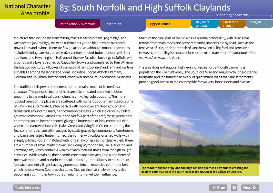
structures that include the transmitting masts at Mendlesham (305 m high) and Tacolneston (206 m high), the wind turbines at Eye and high-tension overhead power lines and pylons. There are few great houses, although notable exceptions include Helmingham Hall, an early-16th-century moated Tudor mansion with later additions, and Heveningham Hall, one of the few Palladian buildings in Suffolk, with grounds and a lake fashioned by Capability Brown (and completed by Kim Wilkie in the late 20th century). Pillboxes of the 1940 military ‘stop lines’ and remnant wartime airfields lie among the landscape. Some, including Thorpe Abbotts, Parham, Horham and Rougham, host Second World War Bomb Group Memorial Museums.
The traditional dispersed settlement pattern retains much of its medieval character. The principal manorial halls are often moated and sited in close proximity to the medieval parish churches in valley-side positions. The more ‘upland’ areas of the plateau are scattered with numerous other farmsteads, some of which are also moated, interspersed with more concentrated groupings of farmsteads around the margins of common pastures which are variously called greens or commons. Particularly in the Norfolk part of the area, these greens and commons can be interconnected, giving an impression of long commons that widen and narrow at intervals. Hales Green and Wingfield Green are among the few commons that are still managed by cattle grazed by commoners. Farmhouses and barns are largely timber framed, the former with colour-washed walls with steeply pitched roofs if thatched with long straw or less so if originally tiled. There are a number of small market towns, including Wymondham, Eye, Harleston and Framlingham, which contain a wealth of architectural styles from the 15th to 19th centuries. While retaining their historic core many have acquired a perimeter of post-war modern and pseudo-vernacular housing. Immediately to the south of Norwich, ancient villages have agglomerated into an extensive commuter belt which lends a Home Counties character. Diss, on the main railway line, is also becoming a commuter town but still retains its market town influence.
Much of the rural part of the NCA has a residual tranquillity, with large areas remote from main roads and some remaining inaccessible by road, such as the fens west of Diss, and the stretch of land between Billingford and Brockdish. However, tranquillity is reduced close to the main transport infrastructure of the A11, A12, A14, A140 and A143.
The area does not support high levels of recreation, although canoeing is popular on the River Waveney. The Boudicca Way and Angles Way long-distance footpaths and the intricate network of quiet minor roads that link settlements provide good access to the countryside for walkers, horse riders and cyclists.
The modern shapes of pylons and high-tension overhead powerlines crossing the ancient countryside in the south-east of the NCA near the village of Clopton.

13
83: South Norfolk and High Suffolk ClaylandsSupporting documents
National CharacterArea profile:
The landscape through time
The underlying bedrock of the South Norfolk and High Suffolk Claylands is Cretaceous ‘Middle’ and ‘Upper’ Chalk, deposited between 100 and 65 million years ago, and Neogene/Quaternary shallow marine sands and gravels known locally as Crag. Silica was left behind and formed nodules of hard flint within the Chalk. About a million years ago sands and gravels were deposited by the ancestral River Thames which flowed north-eastwards across the eastern edge of this area, and the Bytham River which flowed from the Midlands and along much of the course of the later Waveney.
The area was strongly influenced by the Anglian Glaciation, which swept over most of East Anglia around 450,000 years ago, eroding the earlier chalk and Jurassic clays along its path and forming a mantle of till up to 75 m thick, and associated outwash sands and gravels which capped the bedrock. The resulting plateau dissected by shallow river valleys dominates the physical character of the NCA, while remnants of former flood plains are preserved as suites of river terraces in the valleys. Lakes formed in the depressions (for example, at Hoxne) and, as the climate warmed over thousands of years, layers of peat built up creating an interconnected series of valley fens along the Little Ouse and Waveney. Solution processes in the chalk bedrock created the basin lake of Diss Mere; its sediments contain the most complete record of Holocene environmental change in the UK.
There was certainly human occupation in this area before the Anglian Glaciation but most traces of it have been obliterated by the Anglian ice sheet. Hoxne is the most important post-Anglian Palaeolithic site and type-site for the Hoxnian Stage of the Pleistocene. Later prehistoric settlement focused on the fringes of the plateau and the river valleys, whose slopes were easier to drain and cultivate than
the poorly drained central plateau, which developed a thick tree cover. Areas of prehistoric coaxial field systems survive in the Scole–Dickleburgh–Yaxley area.
By the 1st century ad human settlement was expanding into the central wooded areas, and by the end of the Roman occupation a network of dispersed settlements spread across the area, although the widest interfluve plateau has always been least favoured. By 1066, most of the present villages and many isolated farmsteads and hamlets had been established and the area was one of the most densely populated in England. A large number of Saxo-Norman round tower churches and medieval churches were built, with notable examples at Wymondham, North Lopham, Framlingham, Eye and Laxfield. The lack of a good local freestone meant that most churches were built of irregular field flints set in mortar. Their characteristic round towers, more common in Norfolk than Suffolk, are most probably a reflection of the region’s strong cultural links with the countries bordering the Baltic and North Sea.
The medieval church of St Andrew at Norton, one of a large number of medieval churches that appear as focal points in the landscape.

14
83: South Norfolk and High Suffolk ClaylandsSupporting documents
National CharacterArea profile:
Expanding populations in the 11th and 12th centuries led to the establishment of ‘secondary’ settlements on the central plateau. These often gathered around the edges of large grazed commons or greens which replaced former areas of woodland and wood pasture, such as at Mellis, Burgate, Chippenhall, Wortham and Old Buckenham. These green-side settlements continued to be formed into the 13th and 14th centuries. Diss and Harleston, which were on the main coaching route from London to Great Yarmouth, expanded as two of the most important market towns in Norfolk and there, and also at Scole, a number of fine coaching inns remain as a legacy of that time.
Although Norfolk and Suffolk were two of the least wooded counties in medieval times, the area contained several privately enclosed deer parks, such as at Framlingham, Dennington, Earl Soham and Saxtead. These often contained pollarded trees which were a valuable commodity in a relatively treeless landscape. Sotterley Park is a fine example of a ‘pseudo-medieval’ 18th-century park. Infield trees were numerous in the wood pasture areas, and field-edge ‘rows’ were commonplace up to the Napoleonic Wars. The alternative name of ‘Woodlands’ for High Suffolk has an implied contrast between the openness of the adjacent areas such as the Suffolk Sandlings and The Brecks (where there were large common fields) and this formerly well-treed area.
The mixed arable and dairying economy that evolved encouraged the concentration of wealth in a broad central swathe of lesser gentry and substantial numbers of yeoman farmers. Today this is reflected in the high number of sizeable moated farmhouses, especially across Suffolk. Demesne farms and fields were large, with some fields of over 40 ha, contrasting with the smaller fields of the tenant farmers. Early tenant holdings usually had dispersed fields and ‘pieces’ of land, and over time there was a marked trend to buy, sell and swap land in order to create ring-fenced holdings. Farm sizes grew after the Black Death, and this has continued to the present day.
Houses built on the plateau required water and drainage, both of which could be provided by digging a moat, although the main purpose of moats is believed to have been to act as a status symbol. These predominantly timber-framed houses are often concealed behind colour-washed plaster. Barns along with rare surviving cattle housing (locally termed ‘neathouses’) and other farm buildings from this period are of great historic and architectural interest and form one of the most widespread and impressive survivals of pre-1750 farmstead buildings. From the 1790s South Norfolk also acquired a national reputation for its barns, which further reflect the wealth and pride of the area’s farmers. Brick was increasingly used from the 16th century and ‘fashionable’ 18th- or 19thcentury brick facades often conceal older timber frames. ‘Clay lump’ (large bricks of unfired clay and straw) was also used for farm buildings, cottages and some farmhouses in the first half of the 19th century when there was a tax (introduced in 1784, repealed in 1850) on fired bricks.
Although predominantly a farming area which was described by the great agricultural writer Arthur Young as being the ‘dairying region’ of the country, a cottage industry developed in the 16th to 18th centuries with linen weavers processing locally grown hemp and flax. They contributed to the local landscape with the necessary ponds in which the plants were ‘retted’ (soaked to separate the fibre from the plant stems) before further processing. There were several markets for linen, sailcloth and sackcloth, particularly in the Waveney Valley, close to the main growing area between Eye and Beccles. Although linen weaving was labour intensive it combined well with farming and its cultivation fitted better with dairy farming than with arable. Trade declined in the late 18th century.
From the late 18th century the high price of grain and the urban demand for foodstuffs ushered in the period of Victorian ‘High Farming’. The introduction of clay drains, for under-field drainage, enabled the conversion of many of the dairying pastures into more lucrative arable units. This conversion led to the

15
83: South Norfolk and High Suffolk ClaylandsSupporting documents
National CharacterArea profile:
rationalisation and straightening of many of the small, meandering fields. Ancient woodlands were also grubbed up and fens were drained for agricultural use. Greens were also enclosed and linear greens were often built on to accommodate the rapidly rising population. A large number of windmills used for milling wheat or barley were at work across the area, but their numbers declined, slowly at first but rapidly after 1900, in the face of competition from large steam-powered flour mills and smaller farm mills driven by steam or internal combustion engines. The onset of the Second World War saw military ‘stop lines’ drawn across the countryside, with pillboxes appearing at key locations and a high number of fighter and particularly bomber airfields constructed across the plateau. Examples
The view from the control tower at the old Parham Airfield (also known as RAF Framlingham). Parham was one of many military airfields built across the open expanse of the flat plateau during the 1940s.
include Parham, Seething and Mendlesham.
The rapid post-1950 intensification of farming changed the face of this landscape in many places. Most notable was the loss of narrow stream-side ribbons of meadow, field ponds, further ancient woodland and many hedges. The removal of hedges affected primarily internal farm boundaries and older (medieval or earlier) holding boundaries survived in many places. Wetland habitats were further drained, with the result that what was once a largely well-connected wetland in the valleys was reduced to a group of isolated fens. The only areas to escape these changes were those owned by local charitable bodies that held pockets of fen on behalf of the poor of the parish.
The 1970s saw the outbreak of Dutch elm disease, which removed the once-common sight of mature elm trees from the landscape. Development pressure in the late 20th century focused almost entirely on those towns that were well served by road and rail, such as Diss and Wymondham, which now have modern housing estates attached to them.
Today, comparatively little remains of the historic wood pasture which characterised this area up until the 18th century, but woodland has always been carefully husbanded as the numerous hedgerow trees, both standards and pollards, bear witness. Copses have been planted as game cover and there is still a scatter of ancient semi-natural woods such as Burgate Wood and Wyken Wood. While only a fraction of the species-rich grassland that existed in the 1940s remains, a significant proportion is managed sympathetically by owners and new species-rich hay meadows have been created in private nature reserves and through community-based projects. Some 90 per cent of the remaining wetlands – five valley fens – are looked after by the Suffolk Wildlife Trust as nature reserves, and agri-environment initiatives are working well to preserve the traditional function and appearance of the fragile valley ecosystems, especially in the Waveney Valley.

16
83: South Norfolk and High Suffolk ClaylandsSupporting documents
National CharacterArea profile:
Ecosystem services
The South Norfolk and High Suffolk Claylands NCA provides a wide range of benefits to society. Each is derived from the attributes and processes (both natural and cultural features) within the area. These benefits are known collectively as ‘ecosystem services’. The predominant services are summarised below. Further information on ecosystem services provided in the South Norfolk and High Suffolk Claylands NCA is contained in the ‘Analysis’ section of this document.
Provisioning services (food, fibre and water supply) ■ Food provision: 90 per cent of the land area is farmed with the widespread chalky clay soils (mostly Grades 2 and 3), equable climate and low-to-moderate rainfall supporting predominantly arable farming with large areas of cereals and oilseed rape.The area also provides dairy products and sugar beet, and there are fruit farms and market gardening on areas of lighter land. Livestock farming includes pigs, poultry, sheep and lowland cattle. Value-added food producers (for example, organic producers, pork butchers and brewers) cluster around market towns such as Diss and Wymondham, as do several ‘pick your own’ farms.
■ Water availability: Water for human consumption, industrial use and agricultural irrigation of crops comes from the major underground chalk aquifer as well as locally important sand and gravel aquifers that overlie the Chalk. The rivers, primarily the Waveney, Deben, Gipping, Alde, Blyth and Dove, are also important sources of potable and irrigation water although these are currently over-abstracted. Groundwater resources within the chalk aquifer are currently committed, and new groundwater abstraction applications are only considered from drift deposits for non-consumptive purposes, highlighting the scarcity of water in the area.
■ Genetic diversity: There are two dual-purpose chickens that originate from the NCA; the Ixworth chicken originates from Ixworth in Suffolk and the Norfolk Grey from Hethel in Norfolk. Both breeds are on the rare breeds list. The NCA also contains members of the ‘Suffolk Trinity’ – the Suffolk Punch heavy horse, Red Poll Cattle and Black Faced Sheep. Konik ponies, which are related to the wild European horse, are used to graze Redgrave and Lopham Fen National Nature Reserve (NNR). Remnant traditional orchards also provide a genetic stock of old apple varieties, many of which are no longer commercial (for example, the Suffolk Thorn pear raised at Glevering Hall, Hacheston, and apples including Lady Henniker from Thornham Hall and Suffolk Pink and Winter Wonder from the Braiseworth nurseries near Eye).
Early summer agricultural spray application to barley that is being grown on the widespread moderately fertile chalky clay soils.

17
83: South Norfolk and High Suffolk ClaylandsSupporting documents
National CharacterArea profile:
Regulating services (water purification, air quality maintenance and climate regulation)
■ Regulating water quality: Water quality is important for biodiversity, agriculture and public drinking water. The chemical status of groundwater is generally good. Some 29 per cent of rivers are assessed as having good chemical status and 27 per cent of rivers are assessed as having good or high biological status. Both groundwater and surface water quality is critically dependent on the land management in the NCA. Woodlands, hedgerows, grasslands, riparian vegetation and the filtering qualities of the underground sand and gravel and chalk deposits all contribute to the service. The main land use in the catchment is arable agriculture which has the potential to affect water quality (both ground and surface waters) through agricultural run-off. Subsequently all river catchments are priority catchments under the Catchment Sensitive Farming Project.
Cultural services (inspiration, education and wellbeing) ■ Sense of place/inspiration: The small-scale, intimate river valleys, along with their mixed land use patterns, contribute to the deeply rural character. Small woodlands and copses linked by hedgerows with hedgerow trees create a treed character around the edges of the open arable plateau. The presence of medieval churches and windmills provides important points of reference and vertical scale in the otherwise generally flat landscape. Large greens/commons and dispersed settlement, timber-framed houses and farm buildings, often rendered and colour-washed, with clay tiles or long-straw thatch add distinctiveness. Feelings of inspiration are associated with the strong historic character of the medieval settlements, while the surrounding landscape with its wide views, open skies and unspoilt rural tranquillity has provided inspiration for artists. Saxtead Post Mill provides a strong sense of place and history, as seen here lit by the
High Suffolk evening light.

18
83: South Norfolk and High Suffolk ClaylandsSupporting documents
National CharacterArea profile:
■ Sense of history: Historical assets are clearly visible throughout the landscape, providing a strong sense of how the landscape has developed through time. These include Roman roads, Saxo-Norman and many medieval churches, Norman castles, ancient woodlands and 19thcentury windmills. Country houses with historic parklands, such as Heveningham Hall with its ‘Capability’ Brown landscape and Helmingham Hall, whose gardens are open to the public, illustrate past wealth. The area’s wartime importance remains visible, with numerous Second World War airfields, some of which are still used for flying while others are just remnants alongside hangars and pillboxes. Some contain Memorial Museums to the Bomb Groups that flew out of them during wartime, allowing the public to understand the area’s strategic wartime importance. Distinctive historic features that illustrate the area’s long history of settlement include medieval enclosures and moated farmsteads, villages around greens and commons, historical barns and other farm buildings, and small medieval market towns such as Diss, Harleston, Framlingham and Wymondham, which contain many Grade I Listed Buildings in the vernacular style.
■ Tranquillity: The central plateau has some extensive areas of high tranquillity as large areas of agricultural land predominate. Bands of lower tranquillity occur along major roads that dissect the NCA such as the A140 and A143. Away from main roads, tranquillity increases and there is a considerable small-scale patchwork of particularly tranquil places remote from village centres and busy roads.
■ Recreation: The NCA offers a network of rights of way totalling 2,978 km, as well as a small amount of open access land covering 1,873 ha. Recreation is dispersed through facilities in the market towns and villages, and by use of the footpath network. Country parks and nature reserves (mostly woodland, fen or meadow), including Redgrave and Lopham Fen NNR, are freely available for public use. Angling in rivers or in river valley restored gravel pits and canoeing (on the River Waveney) form an appreciable part of the countryside recreational activities. The facilities are generally used by local people and there is little tourism demand for countryside recreation. The networks of quiet lanes are well suited to cycling and horse riding.

19
83: South Norfolk and High Suffolk ClaylandsSupporting documents
National CharacterArea profile:
SEO 1: Maintain and enhance the rural character of the landscape and the contrast between the arable plateau and pastoral river valleys by maintaining agricultural productivity and encouraging sustainable land management practices that protect and enhance the landscape, geodiversity and biodiver-sity assets while benefiting water quality and water availability, as well as the rural sense of place and of tranquillity.
For example by: ■ Maintaining the mix of relatively small, individual landholdings with
scattered small parkland estates; the remnant medieval ancient countryside with its irregular small fields with pollarded hedgerow trees and coaxial field patterns which mostly exist to the east of Scole; and the small-scale pasture and wetland vegetation in the shallow river valleys.
■ Encouraging the maintenance and creation of field-edge/field-corner habitats such as grass margins, uncropped strips, hedges and ditches, trees and ponds in order to support rare arable weeds and farmland bird species such as yellowhammer, grey partridge and tree sparrow.
■ Encouraging, where appropriate, the reversion from arable to permanent grassland and the creation of grass margins in arable fields on valley sides, to help to reduce soil erosion and sedimentation of watercourses, especially within the priority catchments.
■ Encouraging sustainable farming practices and the diversification of cropping and livestock to support the continued production of food supplied to local and national markets and the financial security of rural businesses.
■ Working with farmers and landowners to create ecological networks through the farmed landscape to benefit biodiversity (for example, by increasing farmland bird populations) and to enhance ecosystem services, such as by intercepting surface water to improve water quality and by providing more habitats for pollinator and pest-regulating species.
■ Encouraging farmers to protect watercourses from water quality deterioration, reducing diffuse pollution by encouraging soil management improvements and the uptake of beneficial agri-environment schemes and options. Ensure compliance with regulations in nitrate vulnerable zones to manage fertiliser inputs.
■ Working in partnership with farmers to encourage the appropriate design and sensitive siting of new on-farm water storage, which will help to reduce the impact of water abstraction and enhance biodiversity and landscape character.
■ Enhancing soil condition through good soil management techniques that reduce erosion, improve productivity and have a positive effect on water quality. This can be achieved through reducing cultivation and soil compaction, creating grass margins in arable fields and restoring boundary hedgerows, which will also increase habitats for pollinators and pest-regulating species.
■ Conserving and maintaining the high levels of tranquillity associated with much of the area, especially where there is little settlement or infrastructure intrusion.
Statements of Environmental Opportunity

20
83: South Norfolk and High Suffolk ClaylandsSupporting documents
National CharacterArea profile:
SEO 2: Encourage measures that conserve and enhance the characteristic historic settlement patterns including notable village commons and greens, and historic features such as moated farmsteads and windmills, ensuring that access and educational opportunities are maximised; and ensure that the design and location of new developments add to the sense of place and history across the National Character Area (NCA).
For example by: ■ Conserving and appropriately managing the built environment and the area’s traditional settlement patterns, and planning for well-designed new development inspired by local character, particularly within the market towns where new development is proposed, including Diss, Long Stratton and Wymondham.
■ Promoting the use of traditional building materials as appropriate to enhance the significance and locally distinctive character of the area’s traditional architecture.
■ Ensuring that local development frameworks recognise the importance of conserving and enhancing the landscape and the sense of history to help to reduce the likelihood of negative impacts from new developments.
■ Supporting the use of historic and landscape characterisations to inform change, and encouraging their use in community-based planning to help to identify locally valued townscapes, rural landscapes and historic features.
■ Investigating ways of securing better management of the heritage assets that contribute to the character of the area, particularly those that have been identified as ‘Heritage at Risk’.
■ Recording traditional farm buildings prior to demolition or conversion, and listing/protecting those not recorded in previous listing surveys.
■ Maintaining the distinctive character, settlement form and building materials of the villages and market towns. Improve their setting and settlement fringes through the allocation of new greenspace and woodland planting.
■ Encouraging the retention and enhancement of historic features and heritage assets including their setting in the farmed landscape, for example moated farmsteads and the biodiversity of their moats, barns and other farm buildings, windmills and watermills, and churches.
■ Conserving the distinctive medieval churches, such as Wymondham, North Lopham, Framlingham, Eye and Laxfield, and ensuring that their setting and visual presence in the landscape are retained for their contribution to sense of place.
■ Conserving the distinctiveness of the rare surviving historic commons and greens, many of which have a valued flora (for example, Chippenhall, Mellis Hales and Old Buckenham). Limit the vehicular access points to such greens and conserve their distinctive settlement margins.
■ Highlighting linear green boundaries which are at great risk of erasure through extension of gardens, roadside developments, road infrastructure and other development.
■ Conserving and protecting the historic parklands and their houses/mansions, such as Thornham Magna, Helmingham Hall and Heveningham Hall.
■ Retaining and restoring historic green lanes and former droveways, giving priority to fragmented sections and bridleways.
■ Promoting the archaeological record and the value of geological sites and landscapes in preserving a record of past landscapes and links between historical sites, archaeological evidence/potential and the geological interest of the area, to achieve a wider understanding of the importance of the NCA.
■ Providing interpretation and educational facilities to explain the geoheritage and heritage assets in the area.

21
83: South Norfolk and High Suffolk ClaylandsSupporting documents
National CharacterArea profile:
SEO 3: Maintain and enhance the river valleys and their grazed flood plains, as well as the important valley fens and riparian habitats, for their contribution to bio-diversity networks, geodiversity, soil quality, water availability and regulating water flow and for their contribution to the traditional rural character of the area.
For example by: ■ Conserving and managing the range of riverine and wetland habitats such as fens and wet woodland to enhance the ecological networks they form throughout the area and into neighbouring NCAs, to support rare species such as fen raft spider, Desmoulins’s whorl snail, otter and water vole.
■ Working with landowners to protect, enhance and reinstate the area’s significant valley fens, particularly those under international designation in the Waveney Valley, and maximise opportunities to expand and link these habitats to enhance ecological networks, help to increase water quality, aid water flow management and provide habitat for breeding waders and overwintering wildfowl.
■ Working with landowners to encourage land management practices that help to maintain and increase water infiltration and aid aquifer recharge, such as grassland on the valley sides and floors, to support spring-fed habitats and river flows, potable and irrigation water supply, and soil quality.
■ Increasing the use of river valleys for flood storage, encouraging peat formation and habitat creation that strengthens the rural character.
■ Working with landowners to help to reduce river bank erosion and improve water quality through managing livestock access to rivers and streams in order to prevent bank damage and increased sedimentation.
■ Continuing to use agri-environment schemes to restore and re-create valley grassland ribbons, and discouraging tree planting and removing trees on existing ribbons, benefiting the landscape, semi-natural habitats, aquifer recharge, water quality and soil erosion reduction, as well as limiting flood risk.
■ Ensuring that local development plans include the sustainable management of water resources and promote measures to reduce adverse impacts on water quality in the future, including the use of sustainable drainage systems.
■ Protecting the archaeology and history of human settlement in the flood plain areas by encouraging appropriate non-intensive land management and reinstating permanent pasture where possible.
■ Maintaining isolated ponds which are a characteristic feature of the clay plateau for their landscape and biodiversity value, particularly their populations of great crested newt.
■ Continuing to restore mineral extraction sites to a variety of wetland habitats, for their multiple benefits for geodiversity, nature conservation, and recreational and landscape interests.
■ Working in partnership to reduce threats posed by non-native species’ colonisation of the open water and riverine habitats.

22
83: South Norfolk and High Suffolk ClaylandsSupporting documents
National CharacterArea profile:
SEO 4: Protect and enhance the area’s ancient semi-natural woodlands, copses, river valley plantations and ancient boundaries including hedgerows and hedgerow trees, through the management of existing and the creation of new woods and hedgerows to benefit biodiversity, landscape character and habitat connectivity, and for the benefits to soil erosion reduction, water infiltration and quality, timber provision and carbon storage.
For example by: ■ Promoting appropriate management techniques, such as restoring coppice rotations in woodlands, to restore and enhance ancient woodland habitats as well as strengthening the historic character of these woods and increasing the provision of timber and coppice products.
■ Creating and managing new small-to-medium-sized woods, particularly on the plateau/plateau edges, to compensate for known lost woods or portions of woods and restore existing ancient woodland to its original shape and boundary where appropriate.
■ Encouraging the reinstatement of active management of existing farm woodlands where they have been neglected, promoting the use of wood fuel as a renewable energy as well as the carbon storage benefits of new woodland areas.
■ Encouraging local businesses to increase appropriate-scale generation of heat, utilising woody biomass for woodchip boilers, where it is sustainable to do so, in turn bringing further opportunities for improved woodland management, while being mindful of locally valued landscape characteristics, habitats and species.
■ Restoring hedgerows on significant previously hedged field boundaries (including by traditional coppicing, which will also be a source of wood fuel) and managing existing/restored hedgerows to aid reduction of soil erosion and provide biodiversity networks and for their contribution to sense of place and history in the agricultural landscape.
■ Continuing the pollarding of oak and ash (chalara permitting), hornbeam and maple in hedgerows and willow in the river valleys to ensure the longevity of the trees, creating new pollards for the future to enhance the historic character of the landscape.
■ Managing surviving elm in hedges by employing a tight cutting rotation and propagating and planting new elm trees for the future from Dutch elm disease survivors.
■ Increasing the wooded character of the river valleys where appropriate and where there is no conflict with the historic landscape (for example, avoiding tree planting on traditional valley grasslands), to help to reduce soil erosion, benefit water quality, and aid water infiltration and water flow.
■ Extending and linking woodland sites through the expansion and enhancement of semi-natural linear features such as hedgebanks, hedged lanes, grass verges and wooded shelterbelts, enhancing biodiversity and landscape character.
■ Restoring traditional orchards, once a feature of settlements, with local varieties of fruit tree, to support the area’s sense of place and genetic diversity.
■ Encouraging communities and schools to become involved in creating, conserving and enhancing local woods, by working with partners to promote volunteering opportunities.
■ Creating new woodland as appropriate to screen new development and provide habitat and green infrastructure benefits.

Additional opportunity
23
83: South Norfolk and High Suffolk ClaylandsSupporting documents
National CharacterArea profile:
1: Improve opportunities for people to access, enjoy and understand rural and historic landscape assets, ensuring that access and recreational resources are managed to be compatible with the tranquillity of the area, while providing a valuable health, education and access resource.
For example by: ■ Supporting the delivery of access improvements as identified in the Suffolk County Council and Norfolk County Council Rights of Way Improvement Plan and the Greater Norwich Green Infrastructure Strategy, to provide sustainable access routes.
■ Creating new access links within and between local communities and amenities and natural public greenspace, especially in areas of need as identified in Natural England access maps.
■ Working with landowners and farmers to develop multi-user routes and improve route connectivity, characterised by good-quality surfacing, signage and solutions to route severance, to improve opportunities for people to access the countryside on foot, cycle and horse and with wheelchairs and pushchairs.
■ Exploring working with partners and organisations that support volunteering in the natural environment, which provides opportunities for people to increase their knowledge and understanding of the local area, while also benefiting geodiversity, semi-natural habitats and species.
■ Raising awareness of the important sensitive habitats and the wildlife that they support, such as species-rich grassland on greens and commons and valley fen habitats, through clear signposting and interpretation, to improve the quality of understanding and enjoyment of the natural environment.
■ Encouraging local schools and community groups to become involved in projects and other educational opportunities to develop a better understanding of their natural and historical environment and to help to preserve it for the future.
■ Creating access opportunities with consideration to minimising the risk of damage to landforms from recreation, particularly in the valleys, and promoting appreciation of the geological resource by local communities and visitors.
■ Promoting links between geological sites, archaeological evidence and the biological interest of these areas, to achieve wider public understanding and enjoyment.
■ Managing and further enhancing access and recreational opportunities which centre on enjoyment of the tranquil and deeply rural countryside via the network of quiet lanes, villages, footpaths, bridleways and watercourses, to facilitate and encourage access to the wider countryside for all users.
■ Promoting access to, interpretation and understanding of less well-known sites and features as well as promoting access to features via established routes such as the Mid Suffolk Footpath and the Boudicca Way and Angles Way long-distance footpaths.

24
83: South Norfolk and High Suffolk ClaylandsSupporting documents
National CharacterArea profile:
Supporting document 1: Key facts and dataTotal area: 214,517 ha
1. Landscape and nature conservation designationsThe South Norfolk and High Suffolk Claylands NCA contains 108 ha of the Broads National Park.
Source: Natural England (2011)
1.1 Designated nature conservation sitesThe NCA includes the following statutory nature conservation de1signations:
Tier Designation NameArea (ha)
% of NCA
International Ramsar Redgrave and South Lopham Fens, Broadland
129 <1
European Special Protection Area (SPA)
Broadland SPA 6 <1
Special Area of Conser-vation (SAC)
Waveney and Little Ouse Valley Fens SAC, Norfolk Valley Fens SAC, Dew’s Ponds SAC, The Broads
215 <1
National National Nature Re-serve (NNR)
Lopham Fen NNR 127 <1
National Site of Special Scientific Interest (SSSI)
A total of 54 sites wholly or partly within the NCA
1,113 <1
Source: Natural England (2011)
Please note: (i) Designated areas may overlap (ii) all figures are cut to Mean High Water Line, designations that span coastal areas/views below this line will not be included.
In summary, land covered by international nature conservation designations totals 215 ha (<1 per cent of the total land area). In total, 1,113 ha of the NCA are nationally designated. All NNRs are included within SSSI designations. There are 496 local sites in South Norfolk and High Suffolk Claylands covering 3,549 ha (2 per cent of the NCA).
Source: Natural England (2011)
■ Details of individual Sites of Special Scientific Interest can be searched at: http://www.sssi.naturalengland.org.uk/Special/sssi/search.cfm
■ Details of Local Nature Reserves (LNR) can be searched: http://www.lnr.naturalengland.org.uk/Special/lnr/lnr_search.asp
■ Maps showing locations of Statutory sites can be found at: http://magic.defra.gov.uk/website/magic/ – select ‘Rural Designations Statutory’.
1.1.1 Condition of designated sites
SSSI condition category Area (ha)% of SSSI land in
category conditionUnfavourable declining 120 11
Favourable 456 41
Unfavourable no change 89 8
Unfavourable recovering 442 40
Source: Natural England (March 2011)
Details of SSSI condition can be searched at: http://www.sssi.naturalengland.org.uk/Special/sssi/reportIndex.cfm

25
83: South Norfolk and High Suffolk ClaylandsSupporting documents
National CharacterArea profile:
2. Landform, geology and soils2.1 ElevationElevation in the NCA ranges from sea level to a high point of 77 m. The mean elevation is 43 m.
Source: Natural England (2010)
2.2 Landform and processThe South Norfolk and High Suffolk Claylands form a large flat plateau with little relief except were incised by small river valleys flowing east to the North Sea. They are a relic of the Anglian glaciation, which swept over most of East Anglia, leaving a mantle of chalky boulder clay (glacial till), sand and gravel. Most of the glacial deposits were derived from a British ice-sheet which moved south across eastern England, eroding chalk and Jurassic clays along its path. In the north there is evidence for deposits derived from a Scandinavian ice-sheet; these are typically less chalky and include erratics of igneous rocks. The till presents a flat surface over wide areas and varies in thickness, being up to 75 m thick on the high ground between Bury St Edmunds and Stowmarket. It gives rise to typical stagnogley soils which, while difficult to work when wet, are extremely fertile if drained. There is a strong contrast between the open plains of the clay plateau and the intimate small-scale valleys fringing the Suffolk Coast and Heaths to the east.
Source: South Norfolk and High Suffolk Claylands Countryside Character Area description.
2.3 Bedrock geologyThe bedrock geology principally consists of a mixture of sand (53 per cent) and chalk (44 per cent). During the Anglian glaciation, around 450,000 years ago, ice sheets moving across the area deposited a layer of boulder clay up to tens of metres thick over the chalk. Fragments of chalk in the clay give a more or less calcicolous feel to the vegetation across the whole area. Pre-glacial river gravels under the clay are an important feature.
Source: South Norfolk and High Suffolk Claylands Countryside Character Area description, Natural England (2010)
2.4 Superficial depositsAs the climate warmed and the ice melted, after the Anglian glaciation fast-flowing streams carried sands and gravels, depositing them in valleys where they can be found today. Source: South Norfolk and High Suffolk Claylands Countryside Character Area description
2.5 Designated geological sites
Designation Number of sitesGeological Site of Special Scientific Interest (SSSI) 4
Mixed interest SSSI 0
There are 13 Local Geological Sites within the NCA.Source: Natural England (2011)
■ Details of individual Sites of Special Scientific Interest can be searched at: http://www.sssi.naturalengland.org.uk/Special/sssi/search.cfm
2.6 Soils and Agricultural Land ClassificationSoilscapes maps identify the soils as a combination of slowly permeable seasonally wet slightly acid but base-rich loamy and clayey soils and more fertile slightly acid loamy and clayey soils with impeded drainage, found typically around the river valleys.
Source: National Soil Research Institute Soilscape Maps

26
83: South Norfolk and High Suffolk ClaylandsSupporting documents
National CharacterArea profile:
The main grades of agricultural land in the NCA are broken down as follows (as a proportion of total land area):
Agricultural Land Classification Area (ha) % of NCAGrade 1 0 0Grade 2 30,596 15Grade 3 171,364 80Grade 4 11,530 5Grade 5 0 0Non-agricultural 169 <1Urban 857 <1
Source: Natural England (2010)
Maps showing locations of Statutory sites can be found at: http://magic.defra.gov.uk/website/magic/ – select ‘Landscape’ (shows ALC and 27 types of soils).
3. Key water bodies and catchments 3.1 Major rivers/canalsThe following major rivers/canals (by length) have been identified in this NCA.
Name Length (km)River Waveney 37River Deben 21River Dove 17River Alde 15River Blyth 12River Chet 12River Gipping 5Little Ouse River 4River Thet 3River Lark 1
Source: Natural England (2010)
Please note: other significant rivers (by volume) may also occur. These are not listed where the length within the NCA is short.
The plateau is incised by river valleys flowing eastwards into the North Sea, primarily the Waveney, which forms the Norfolk–Suffolk boundary, and the Gipping, which becomes the Orwell below Ipswich, but also by the Deben, Alde, Blyth and Dove.
3.2 Water qualityThe total area of Nitrate Vulnerable Zone is 214,431 ha, or 100 per cent of the NCA.
Source: Source: Natural England (2010)
3.3 Water Framework DirectiveMaps are available from the Environment Agency showing current and projected future status of water bodies http://maps.environment-agency.gov.uk/wiyby/wiybyController?ep=maptopics&lang=_e
4. Trees and woodlands4.1 Total woodland coverWoodlands over 2 ha cover 10,633 ha of the South Norfolk and High Suffolk Claylands NCA of which 1,266 is ancient woodland (<1 per cent of the NCA area).
Source: Natural England (2010), Forestry Commission (2011)
4.2 Distribution and size of woodland and trees in the landscapeAlthough well-wooded in the 11th century, much of its ancient woodland had been reduced to dwindling wood pastures by the end of the Middle Ages. The surviving elements are largely confined to small patches dotted along the river valleys. A wooded character is, however, maintained by thick hedgerows with numerous standards and pollards, supplemented by parkland and by numerous modern copses and plantations providing shelter and shooting cover. Hedgerow oaks sometimes remain, even where the hedgerows have been removed.
Source: South Norfolk and High Suffolk Claylands Countryside Character Area description.

27
83: South Norfolk and High Suffolk ClaylandsSupporting documents
National CharacterArea profile:
4.3 Woodland typesA statistical breakdown of the area and type of woodland found across the NCA is detailed below.
Area and proportion of different woodland types in the NCA (over 2 ha)Woodland type Area (ha) % of NCABroadleaved 8629 4
Coniferous 1041 <1
Mixed 300 <1
Other 663 <1Source: Forestry Commission (2011)
Area and proportion of Ancient Woodland and Planted Ancient Woodland within the NCA.
Woodland type Area (ha) % of NCAAncient semi-natural woodland 1,266 <1
Ancient re-planted woodland (PAWS) 628 <1Source: Natural England (2004)
5. Boundary features and patterns5.1 Boundary featuresA mix of remnant medieval ‘ancient countryside’ consisting of irregular small fields often bounded with unkempt and poorly managed hedgerows containing pollarded oaks and large modern fields devoid of boundary hedgerows and trees. On the clay plateau boundaries are often formed by deep ditches often notable by their attendant trees and shrubs.
Source: South Norfolk and High Suffolk Claylands Countryside Character Area description; Countryside Quality Counts (2003)
5.2 Field patternsIn essence this is an area of ‘ancient countryside’, but its character has been much weakened by hedgerow removal and field amalgamation in the second half of the 20th century. The original field patterns had a co-axial character, the principal axes consisting of long more-or-less parallel boundaries that ran at right angles to the main watercourses. These patterns were particularly strong in the Scole/Dickleburgh area of Norfolk and in the South Elmham/Ilketshall area of Suffolk. Although ‘ancient’ in character, estimates of their age range from prehistoric to medieval. Common or ‘open’ fields were limited in extent and most had disappeared by Tudor times. By the late 18th century barely 10 per cent of the landscape remained unenclosed, with the majority of the land being divided into small hedged closes, averaging as little as 2 ha. Most were pastures used for dairy farming, but from the late 18th century improved under-field drainage and increasing grain prices led to widespread arable conversion. The late 20th century saw further enlargement of arable fields, breaking down the earlier patterns and giving some areas of the plateau a prairie-like character. The area south of Wymondham and north-west of Framlingham appears to have undergone most field amalgamation.
Source: Draft Historic Profile Countryside Character Area description; Countryside Quality Counts (2003)
6. AgricultureThe following data has been taken from the Agricultural Census linked to this NCA.
6.1 Farm type In 2009 there were 2,149 holdings within the South Norfolk and High Suffolk NCA, down from 2,241 in 2000. Just over half of the holdings were arable with 21 per cent recorded as livestock and 7 per cent mixed.
Source: Agricultural Census, Defra (2010)

28
83: South Norfolk and High Suffolk ClaylandsSupporting documents
National CharacterArea profile:
6.2 Farm sizeThe majority of the agricultural area (74 per cent) was in farm holdings of over 100 ha, followed by 15 per cent of the area in holdings between 50 and 100 ha and 8 per cent in holdings between 20 and 50 ha. Although the overall agricultural area had declined, the relative proportion of different sized farms had not.
Source: Agricultural Census, Defra (2010)
6.3 Farm ownership 2009: Total farm area = 1798,955 ha; owned land = 146,057 ha 2000: Total farm area = 187,086 ha; owned land = 150,339 ha
Eighty-two per cent of the total farmed area was owner occupied. This decreased by 3 per cent (4,282 ha) between 2000 and 2009, whereas tenanted farmland increased by about 2 per cent (769 ha).
Source: Agricultural Census, Defra (2010)
6.4 Land useThe dominant land use is arable. Cereal production made up more than half the overall land use, grass and uncropped land accounted for 18 per cent and oilseeds for 12 per cent of the agricultural land area in 2009. Between 2000 and 2009 the area used for oilseed production more than doubled from 9,544 ha to 20,937 ha (an increase of 11,393 ha, 119 per cent) overtaking cash roots to cover the second largest area of agricultural land. Most other land uses declined: cereals by 12 per cent (12,680 ha), cash roots by 23 per cent (3,557 ha) and grass and uncropped land by 11 per cent (4,224 ha). The area under glasshouses halved from 14 to 7 ha.
Source: Agricultural Census, Defra (2010)
6.5 Livestock numbersIn 2009 pigs were the most numerous livestock by far within this landscape (339,900) followed by cattle (35,700) and sheep (24,600). Total livestock
numbers declined significantly between 2000 and 2009, most dramatically in the case of pigs numbers, which decreased by 225,600 (66 per cent), followed by sheep 6,000 (24 per cent) and cattle 5,100 (14 per cent). This was mirrored in the decline of specialist pig farms.
Source: Agricultural Census, Defra (2010)
6.6 Farm labourIn 2009 more than half (54 per cent) of the agricultural workforce were the 3,037 principal farmers (including their spouses and business partners). They were followed by full-time workers (21 per cent) and part-time workers (11 per cent), casual / gang workers (9 per cent) and salaried managers (5 per cent). Farm labour had decreased by 23 per cent in this area, from 7,236 in 2000 to 5,594 in 2009, with the net loss of 769 full-time workers, 455 principal farmers, 214 part-time workers and 211 casual/gang workers.
Source: Agricultural Census, Defra (2010)
Please note: (i) Some of the Census data is estimated by Defra so will not be accurate for every holding (ii) Data refers to Commercial Holdings only (iii) Data includes land outside of the NCA belonging to holdings whose centre point is within the NCA listed.
7. Key habitats and species7.1 Habitat distribution/coverage Valley fens are of particular ecological significance. The relationship between the fens and the underlying geology make them particularly important. The Norfolk Valley Fens and the Waveney-Little Ouse Valley Fens on the Norfolk/Suffolk border represent internationally important calcareous fens with Cladium mariscus and Carex davalliana vegetation. More than 10 per cent of the national resource is contained in this group of fens, and they are considered to be among the best in the country. Other fens are not common in the NCA. Important species within the fens include Desmoulin’s snail and

29
83: South Norfolk and High Suffolk ClaylandsSupporting documents
National CharacterArea profile:
narrow-mouthed whorl snail both of which are rare in Europe. The density of farm ponds in this area is almost unparalleled in the UK and they support internationally important populations of great crested newt. Rich wildflower meadows exist on undisturbed medieval commons and across the area there are a handful of typically small meadows that have never been fertilised or sprayed and remain botanically diverse.
Source: East Anglian Plain Natural Area Profile.
7.2 Priority habitatsThe Government’s new strategy for biodiversity in England, Biodiversity 2020, replaces the previous Biodiversity Action Plan (BAP) led approach. Priority habitats and species are identified in Biodiversity 2020, but references to BAP priority habitats and species, and previous national targets have been removed. Biodiversity Action Plans remain a useful source of guidance and information. More information about Biodiversity 2020 can be found at; www.naturalengland.org.uk/ourwork/conservation/biodiversity/protectandmanage/englandsbiodiversitystrategy2011.aspx.
The NCA contains the following areas of mapped priority habitats (as mapped by National Inventories). Footnotes denote local/expert interpretation. This will be used to inform future national inventory updates.
Priority habitat Area (ha) % of NCABroadleaved mixed and yew woodland (broad habitat)
9,232 4
Coastal and flood plain grazing marsh 1,292 1
Lowland meadows 378 <1
Purple moor grass and rush pasture 175 <1
Lowland heathland 131 <1
Fens 111 <1
Priority habitat Area (ha) % of NCALowland calcareous grassland 105 <1
Lowland dry acid grassland 86 <1
Reedbeds 4 <1Source: Natural England (2011)
Maps showing locations of priority habitats are available at ■ http://magic.defra.gov.uk/website/magic/ select ‘Habitat Inventories’
7.3 Key species and assemblages of species ■ Maps showing locations of Priority Habitats are available at:
http://magic.defra.gov.uk/website/magic/ ■ Maps showing locations of S41 species are available at http://data.nbn.org.uk/
Redgrave and Lopham Fen form part of the internationally important Waveney-Little Ouse Valley Fens. The wetland habitat supports species including the rare Desmoulin’s snail and fen raft spider.

30
83: South Norfolk and High Suffolk ClaylandsSupporting documents
National CharacterArea profile:
8. Settlement and development patterns 8.1 Settlement patternSettlements tend to be mainly small hamlets or dispersed farmsteads. Manorial halls, often with a medieval church nearby, form ‘primary’ settlement clusters, of likely late-Saxon origin in the river valleys whose slopes were easier to drain and cultivate than the poorly-drained clays of the plateau ‘uplands’. Expanding populations in the 12th and 13th centuries led to the establishment of ’secondary’ settlements that are often gathered around the edges of greens or commons on the adjacent clay uplands, replacing former areas of woodland and wood pasture. The area contains no major post-medieval estates only a scattering of medium-sized ones. There are numerous small market towns such as Wymondham in the north-west, Diss in the centre and Framlingham and Wickham Market in the south-east. Immediately to the south of Norwich ancient villages have agglomerated into an extensive commuter belt.
Source: South Norfolk and High Suffolk Countryside Character Area description; Countryside Quality Counts (2003)
8.2 Main settlementsWymondham, Diss, Framlingham and Wickham Market.
Source: South Norfolk and High Suffolk Countryside Character Area description; Countryside Quality Counts (2003)
8.3 Local vernacular and building materialsTimber-framed farmhouses and barns are a characteristic feature of the area which has one of the highest concentrations nationally of surviving pre-1750 farmstead buildings. The timber frames of the farmhouses are mostly concealed behind colour-washed plaster and the barns are mainly clad with black-painted weatherboarding. Roofs are mainly red clay tiles or thatched, with some slated roofs on 19th century or later buildings. Brick was increasingly used from the 16th century, initially for high status buildings and then for more vernacular buildings. ‘Clay lump’ (large bricks of
unfired clay and straw, usually measuring approximately100 mm by 300 mm) is a distinctive East Anglian building material that was used principally for farm buildings, for cottages and some farmhouses in the middle of the 19th century. The walls were either rendered or given a thin brick skin to make them waterproof. The market towns contain a wealth of architectural styles from the 15th century to the 19th, with some Dutch influence up to 24 km inland in the use of clay pantiles (some black-glazed) on roofs and decorative curved gables. Several of the towns, such as Wymondham, Diss, Long Stratton and Framlingham, while retaining their historic core have acquired a hard perimeter of post-war modern and pseudo-vernacular housing.
Source: South Norfolk Countryside Character Area description; Countryside Quality Counts (2003)
A new thatch, being applied to a timber framed, rendered and colour-washed cottage.

31
83: South Norfolk and High Suffolk ClaylandsSupporting documents
National CharacterArea profile:
9. Key historic sites and features9.1 Origin of historic featuresIron-age and Roman settlement was extensive and grew again in the Saxon pe-riod, so by the time of Domesday most of the present villages were established and the area was one of the most densely populated in England. Round-towered Saxo-Norman churches of flint construction are a particular feature of the north-ern part of the area. The large market towns retain high proportions of 15th to 17th century buildings. There is a high survival of moated houses and these are gener-ally associated with high-status sites and of 13th to 14th century date.
The area did not get caught up in the industrial changes of 19th century hence it has one of the country’s highest concentrations of surviving pre-1750 farmhouses and barns. ‘Neathouses’ for housing cattle are documented and sometimes survive as smaller timber-framed structures dating from the 17th century and later. These are locally distinctive and highly significant where they survive as rare examples of early cattle housing.
A castle at Framlingham is first recorded in 1148, but it was largely destroyed in 1174-5. Its replacement, constructed at the end of the 12th century, has since gone through numerous changes and uses and is now a Scheduled Monument owned by English Heritage.
In the past the area contained several medieval deer parks, as at Framlingham, Dennington, Earl Soham and Saxtead. Sotterley Park in the north-east is a fine ex-ample of a ‘pseudo-medieval’ 18th century park. Heveningham Hall to the south-west of Halesworth is one of the few Palladian buildings in Suffolk, designed by Sir Robert Taylor, with an interior and orangery designed by James Wyatt and the grounds and lake fashioned by ‘Capability’ Brown (the lake completed in the late 20th century by Kim Wilkie).
There are also remnants of wartime airfields at Beccles, Bungay, Rougham, Debach, Eye, Halesworth, Parham, Great Ashfield, Mendlesham, Metfield and Shepher’s Grove in Suffolk and Hethel, Seething, Thorpe Abbotts, Hardwick, Old Buckenham and Tibenham in Norfolk.
Source: Countryside Quality Counts Draft Historic Profile, Countryside Character Area description.
9.2 Designated historic assets This NCA has the following historic designations:
■ 11 Registered Parks and Gardens covering 1,217 ha. ■ No Registered Battlefields. ■ 130 Scheduled Monuments. ■ 7,030 Listed Buildings.
Source: Natural England (2010)
More information is available at the following address: ■ http://www.english-heritage.org.uk/caring/heritage-at-risk/ ■ http://www.english-heritage.org.uk/professional/protection/process/national-heritage-list-for-england/
10. Recreation and access10.1 Public access
■ 0.9 per cent of the NCA 1,873 ha is classified as being publically accessible. ■ There are 2,978 km of public rights of way at a density of 1.4 per km2. ■ There are no National Trails within the NCA.
Sources: Natural England (2010)

32
83: South Norfolk and High Suffolk ClaylandsSupporting documents
National CharacterArea profile:
The table below shows the breakdown of land which is publically accessible in perpetuity:
Access designation Area (ha) % of NCANational Trust (accessible all year) 6 <1
Common Land 649 <1
Country Parks 39 <1
CROW Access Land (Section 4 and 16) 937 1
CROW Section 15 77 <1
Village Greens 45 <1
Doorstep Greens 5 <1
Forestry Commission Walkers Welcome Grants 235 <1
Local Nature Reserves (LNR) 53 <1
Millennium Greens 6 <1
Accessible National Nature Reserves (NNR) 127 <1
Agri-environment Scheme Access 193 <1
Woods for People 467 <1Sources: Natural England (2011)
Please note: Common Land refers to land included in the 1965 commons register; CROW = Countryside and Rights of Way Act 2000; OC and RCL = Open Country and Registered Common Land.
11. Experiential qualities11.1 TranquillityBased on the CPRE map of tranquillity (2006) it appears that the lowest scores for tranquillity are associated with the towns of Diss, Wymondham and Attle-borough, although the majority of disturbance can be seen to be associated with the main transport routes linking these centres, the A140, A11, A12 and A143. The highest scores for tranquillity are within the upper clay plateau on the agricultural land away from the main settlements and the main ‘A’ roads.
A breakdown of tranquillity values for this NCA is detailed in the table below:
Tranquillity Tranquillity ScoreHighest value within NCA 38
Lowest value within NCA -58
Mean value within NCA 2Sources: CPRE (2006)
More information is available at the following address: http://www.cpre.org.uk/what-we-do/countryside/tranquil-places/in-depth/item/1688-how-we-mapped-tranquillity The 2007 Intrusion Map (CPRE) shows the extent to which rural landscapes are ‘intruded on’ from urban development, noise (primarily traffic noise), and other sources of visual and auditory intrusion. This shows that disturbance is associated with the busy ‘A’ roads that run through the area, including the A140, A11, A12 and A143. Intrusion also occurs around the towns of Diss and Wymondham.
A breakdown of intrusion values for this NCA is detailed in the following table.
Intrusion category 1960s (%) 1990s (%) 2007 (%)
Percentage change
(1960s-2007)Disturbed 2 19 27 25
Undisturbed 98 81 72 -26
Urban 0 0 1 1Sources: CPRE (2007)
Notable trends from the 1960s to 2007 were a notable increase of disturbed or intruded land by 25 per cent which was matched by a reduction of undisturbed or un-intruded land by -26 per cent.
More information is available at the following address:http://www.cpre.org.uk/resources/countryside/tranquil-places

33
83: South Norfolk and High Suffolk ClaylandsSupporting documents
National CharacterArea profile:
12 Data sources ■ British Geological Survey (2006) ■ Natural Area Profiles, Natural England (published by English Nature 1993-1998 ) ■ Countryside Character Descriptions, Natural England (regional volumes published by Countryside Commission/Countryside Agency 1998/1999)
■ Joint Character Area GIS boundaries, Natural England (data created 2001) ■ National Parks and AONBs GIS boundaries, Natural England (2006) ■ Heritage Coast Boundaries, Natural England (2006) ■ Agricultural Census June Survey, Defra (2000,2009) ■ National Inventory of Woodland & Trees, Forestry Commission (2003) ■ Countryside Quality Counts Draft Historic Profiles, English Heritage (2004)* ■ Ancient Woodland Inventory, Natural England (2003) ■ Priority Habitats GIS data, Natural England (March 2011) ■ Special Areas of Conservation data, Natural England (data accessed in March 2011) ■ Special Protection Areas data, Natural England (data accessed in March 2011) ■ Ramsar sites data, Natural England (data accessed in March 2011) ■ Sites of Special Scientific Interest, Natural England (data accessed in March 2011)
■ Detailed River Network, Environment Agency (2008) ■ Source protection zones, Environment Agency (2005) ■ Registered Common Land GIS data, Natural England (2004) ■ Open Country GIS data, Natural England (2004) ■ Public Rights of Way Density, Defra (2011) ■ National Trails, Natural England (2006) ■ National Tranquillity Mapping data, CPRE (2007) ■ Intrusion map data, CPRE (2007) ■ Registered Battlefields, English Heritage (2005) ■ Record of Scheduled Monuments, English Heritage (2006) ■ Registered Parks and Gardens, English Heritage (2006) ■ World Heritage Sites, English Heritage (2006) ■ Incorporates Historic Landscape Characterisation and work for preliminary Historic Farmstead Character Statements (English Heritage/Countryside Agency 2006)Detailed River Network, Environment Agency (2008)
Please note all figures contained within the report have been rounded to the nearest unit. For this reason proportion figures will not (in all) cases add up to 100%. The convention <1 has been used to denote values less than a whole unit.

34
83: South Norfolk and High Suffolk ClaylandsSupporting documents
National CharacterArea profile:
Recent changes and trends
Trees and woodlands ■ Assessment of 1999 to 2003 data indicates some enhancement in the levels of woodland cover in the NCA.
■ Between 1999 and 2003 an area equivalent to 6 per cent of the 1999 total stock was approved for new planting under a Woodland Grant Scheme agreement (399 ha). Much of the new planting was in the form of small woodland blocks scattered throughout the area, reinforcing existing patterns.
■ In 2003 the proportion of established, eligible National Inventory of Woodland and Trees woodland stock covered by a Woodland Grant Scheme management agreement was about 39 per cent. The proportion of these sites covered by a Woodland Grant Scheme agreement changed from 18 per cent to 39 per cent between 1999 and 2003 indicating that the woodland character was strengthened.
■ Neglect of ancient woodland and other woodland planting, has impacted on woodland character. About 28 per cent of all woodland is on ancient woodland sites, and there are not significant areas of new planting. Deer are an issue, preventing natural regeneration and coppice regeneration of woodland trees and shrubs. There have been recent improvements in bringing existing farmland woodlands into active management and protecting them from damage caused by grazing deer. Some replanting of woodland has also been carried out, such as at Heveningham Hall where up to 20 ha of broadleaf woodland is being planted each year.
Supporting document 2: Landscape change ■ Semi-natural ancient woodland as well as trees outside of woodland is under threat from the recent arrival of new species of Phytophthora. Ash die back was first reported in 2012.
Boundary features ■ Commercial agricultural improvement combined with a number of other factors has resulted in the loss of some structural landscape features such as hedgerows, ditches, banks, copses and lines of trees. The absence of these features has led in some places to a loss of definition and texture within the landscape although traditionally this has been an open landscape. The extensive removal of hedgerows that took place in the latter half of the 20th century has largely ceased and hedgerow replanting and management under Environmental Stewardship has increased.
■ Between 1999 and 2003, Countryside Stewardship capital agreements for linear features included fencing (79 km), hedge management (116 km), hedge planting and restoration (230 km) and restored boundary protection (12 km). Also further management of hedges through the ESA (Environmentally Sensitive Area). The estimated boundary length for the NCA is about 12,262 km. Total length of agreements between 1999 and 2003, is equivalent to about 4 per cent of this total meaning that the resource had been neglected.
■ Management of hedgerows has improved over recent years with the length of hedgerows in Environmental Stewardship boundary management in 2011 being 4,049 km. As well as this 156 km of woodland, 983 km of ditch, .1km of ditches and .6km of stone-faced ditch bank were also in Environmental Stewardship boundary management schemes.

35
83: South Norfolk and High Suffolk ClaylandsSupporting documents
National CharacterArea profile:
Agriculture ■ Arable farming dominates the area, particularly cereals, with oilseed rape and sugar beet. Between 2000 and 2009 the area of farmed land fell by approximately 8,131 ha. As a result there has been some reduction in mixed and general cropping and cereals. The overall area of grass and uncropped land has decreased although dairying remains important in the Waveney Valley. Increases in horse ownership across the NCA have led to some permanent pasture being used as horse paddocks.
■ Between 2000 and 2009 the land used for growing cereals fell by 12 per cent. Land used for oil seed increased by 11,393 ha (119 per cent). The hectarage of grassland and uncropped land reduced by 11 per cent.
■ Livestock numbers increased significantly during the 1990s and then declined from 2000 to 2009. Pig numbers decreased by 66 per cent (225,600 animals) due to falling prices. Sheep numbers decreased by 24 per cent (6,000 animals), and cattle numbers by 14 per cent (5,100 animals).
Settlement and development ■ Development pressure across the majority of the NCA has generally been low, although scattered development resulting in creeping suburbanisation of many settlements has occurred. Commuter settlement related to railway routes and proximity to larger towns is having an effect on the character of small market towns. Larger scale housing, retail and commercial development has occurred to the north-east of Bury St Edmunds and around the edges of Diss, Halesworth and Wymondham.
■ Similarly, tourism growth has not been significant, especially when compared to adjacent NCAs such as The Broads and Suffolk Coast and Heaths, although there is a thriving smaller-scale assemblage of attractions and accommodation providers.
■ Development across much of the area has been constrained by the relative lack of employment opportunities with the need for affordable homes for local people high amongst community needs.
■ There has been some increased light pollution from development that has detracted from the rural character of the NCA and increases in traffic volumes on the major roads ( A11, A14, A140 and the A143) has resulted in reduced levels of tranquillity.
■ There has been an increase in small scale wind turbines associated with farm enterprises as well as the development of four 130 metre-high turbines at Eye airfield in 2013. The Tacolneston transmitting mast was also extended in 2013 and now stands at 206 m high.
Semi-natural habitat ■ The condition of 40 per cent of the NCA’s SSSI area has been classified as unfavourable recovering with 41 per cent classified as favourable.
■ The area has a high pond density that supports many species including great crested newts. There has been significant restoration of larger ponds both before and since 1999.
■ Loss of ditches, ponds and pasture (especially in High Suffolk) due to field amalgamation and improved drainage techniques has been an issue although this has generally ceased under improved agricultural management.
■ The remaining areas of species-rich grassland have in many places come under positive management either through hay cutting or grazing to help support their rich and diverse flora, including many species of orchid. Some small areas

36
83: South Norfolk and High Suffolk ClaylandsSupporting documents
National CharacterArea profile:
of species-rich hay meadow have also been created by conservation groups and landowners.
■ Improved land management including the addition of grass margins around arable fields over recent years has seen a significant increase in the number and distribution of barn owls. Other farmland birds such as tree sparrow, grey partridge and corn bunting whose populations have crashed have also been supported through sympathetic land management programmes that have focused on farms where threatened birds are still present so that their populations can build up and spread.
■ There has been significant loss of traditional river-valley wetlands and grazing land along the main river valleys, tributary streams and primary ditches, although historic fens such as Redgrave and Lopham Fen, Roydon Fen and Thelnetham Fen are now managed by the Suffolk Wildlife Trust.
■ Conservation efforts have improved and connected the remaining valley fens and wetlands. Sites along the Little Ouse and Waveney support unique plant communities as well as good numbers of amphibians, reptiles, wildfowl and other wetland birds such as great crested grebes and snipe. Mammals including otter and water vole have seen their populations increase over recent years and the fen raft spider has been reintroduced to new parts of Redgrave and Lopham Fen SSSI which has been restored with 100 per cent of the site now in unfavourable, recovering condition.
■ Restoration of ancient woodlands has taken place with improved management at sites, such as the reinstatement of coppice management including Brockley Wood in Thelnetham and Tyrrels Wood SSSI south-east of Long Stratton. Increased deer management has allowed the recovery of rich and diverse woodland ground flora.
■ Non-native species colonisation of semi natural habitats within the NCA has been on the increase, particularly within the river valleys, with species such as mink, which predates on water vole, signal crayfish, which spreads disease to native white-clawed crayfish, as well as non-native wetland plants including floating pennywort and Himalayan balsam.
Historic features ■ Many historic farm buildings have been converted from agriculture to residential use – with a consequent loss of farming character within settlements and the wider landscape, and often with a loss of important, otherwise unrecorded historical / archaeological information within the buildings’ structure. In the period between 1999 and 2003 there were approximately nearly 400 barn conversions. Many more have been converted over the last decade.
The 'Capability' Brown landscape at Heveningham Hall. Here the River Blyth has been restored to its medieval meanders and up to 20 hectares of broadleaf woodland is being planted each year.

37
83: South Norfolk and High Suffolk ClaylandsSupporting documents
National CharacterArea profile:
■ Fifty per cent of the NCA’s historic parkland was lost during the latter half of the 20th century.
■ There has been some development of former airfield sites, such as Stanton and Eye.
■ Historic landscape restoration has taken place at Heveningham which was one of Lancelot Capability Brown’s last designs before he died. Now 200 years later, his plans for 800 ha of parkland and 2 km of lakes have been realised. The River Blyth has been restored to its medieval meanders and up to 20 ha of broadleaf woodland is being planted each year.
■ Gravel extraction in the river valleys is a concern for both earthworks and archaeological sites visible from cropmarks, but may provide significant opportunities for understanding the nationally and internationally important geodiversity and archaeology of all periods from the Neolithic through to the 20th century, as demonstrated at excavations at Flixton Park Quarry.
Rivers ■ High concentrations of both nitrate and phosphate in the river systems mean that all the rivers within the NCA are priority catchments under the Catchment Sensitive Farming initiative. Water quality in the rivers has however improved through measures implemented by sewage treatment works and under agri-environment schemes.
■ Increased water abstraction from the groundwater aquifers as well as the rivers for public water supplies, agriculture and industry has led to reduced river flows and water levels in the valley fens resulting in scrub communities taking hold.
■ The invasive non-native floating pennywort was first recorded in 2007 on the River Waveney. Following establishment, the plant quickly spread to cover an 11 km stretch. Combined efforts by a range of conservation focused partners resulted in the plant being successfully purged from the river in 2013.
Minerals ■ River terrace sands and gravels of the Kesgrave Formation and Lowestoft Formation and glacial outwash deposits have provided significant sources of aggregate, with extraction taking place in locations such as Shotford Heath, Homersfield, Flixton Park and Tostock, leaving a legacy of large water-filled former pits. Production levels have dropped over recent years, reflecting the impact of the economic downturn on the construction industry.
■ Chalk quarrying has now ceased in the NCA. Where active sand and gravel quarrying currently takes place and proposals for site extensions exist, there are challenges as well as opportunities for geodiversity and archaeology.
■ Opportunities for restoration include areas for geological conservation, wetlands and woodland.
Drivers of change
Climate change ■ Changes to rainfall patterns and timings will impact upon wetland features and habitats such as valley fens and farm ponds, particularly the potential for longer periods of drought. Reduced rainfall will impact on water levels and water quality within these habitats, which will impact upon aquatic biodiversity and may also lead to increased scrub incursion. Increased rainfall events will generally benefit these wetland habitats.

38
83: South Norfolk and High Suffolk ClaylandsSupporting documents
National CharacterArea profile:
■ Climate change impacts may also come from increased levels of rainfall particularly during storm events, which may result in flash flooding in the river valleys as well as across the flat plateau. River valleys prevented from evolving naturally may increase flood risks. Increased flash flood events or seasonal flooding events may also impact on footpaths and infrastructure increasing their maintenance requirements.
■ Adapting agricultural practices in response to water availability and longer growing seasons will result in pressure on traditional pastoral landscapes and grasslands in a move towards drought tolerant crops and grasslands. The role of adaptation strategies will become increasingly important.
■ Potentially longer periods of drought may lead to increased pressures on already stressed levels of water availability. Future development will need to address these potential pressures; new methods of water management techniques will play an important role, including taking forward green infrastructure strategies.
■ Climate change may lead to an increase in longer, drier summers, wetter winters, storms, floods and drought; historic woodlands and native species may not be the most resilient and therefore unable to survive reduced soil moisture or extreme events. There may be potential opportunities to alter species mix to build resilience to climate change.
■ Drying out of bedrock and top soil during periods of drought may have associated impacts on the stability of buildings, especially on the clay plateau.
■ Longer, drier summers may reduce soil moisture resulting in desiccation of top soils/surface deposits and may lead to erosion of geological faces/exposures.
■ Palaeo-environmental deposits and sites may be impacted upon by drying out of sub-soils and the subsequent increased erosion from wind and rain.
■ Increased temperatures may lead to the arrival of new non-native species and diseases/ invertebrates as vectors of disease for livestock and crops that could alter land use practices within the NCA.
Sowing the dry clay soils. Adapting agricultural practices in response to water availability will become increasingly important if climate change increases the frequency of periods of drought.

39
83: South Norfolk and High Suffolk ClaylandsSupporting documents
National CharacterArea profile:
Other key drivers ■ Growth is projected at Long Stratton (at least 1,800 new homes and 12 ha of employment land), and Wymondham (at least 2,200 new homes and 20 ha of employment land), as part of the Greater Norwich Growth Area. Additional expansion is planned at Diss and Harleston. Infrastructure constraints remain an issue for continued growth as does the provision and access to employment land.
■ Increased groundwater abstraction could have negative effects on the valley fens found along the Little Ouse and Waveney Valleys as well as to some of the isolated valley meres as at Framlingham and Great Barton.
■ Pressure on tranquillity comes from the proposed growth in and around the traditional market towns and villages close to the main transport links. Increasing car use on the main transport corridors (A11, A12, A14, A140 and A143) causes a gradual erosion of tranquillity. This is especially a pressure along the routes which connect the major settlements that lie in neighbouring NCAs, including Norwich, Ipswich and Bury St Edmunds.
■ The perceived issue of food security may result in further change to farming practices that could impact on ecological habitats and landscape character of the area. Agri-environment schemes provide opportunities to work with land managers to conserve enhance landscape character and develop new networks of linked habitats.
■ There is also a potential increase in the demand for wood fuel and biomass crops as prices for oil and gas for heating and power increase. This could lead to a change in the landscape character of the plateau areas as new arable and biomass crops are planted. The landscape value could be conserved and
enhanced if sites are carefully selected to enhance existing landscape patterns, wildlife corridors and increase opportunities for recreation, providing a multi-functional environmental with social and economic benefits.
■ The ever-increasing deer population is altering the structure of woodlands and climate change will most likely result in further ecological change within the woodland habitats.
■ Ash die-back could potentially have a significant impact as ash is a common and characteristic tree species of the NCA.
■ Restoration of former gravel workings and other mineral sites is a major driver for geodiversity and biodiversity gain, providing opportunities for priority habitats and areas for geological conservation to be created.
■ Potential population growth may lead to increases in the importance of the recreational and environmental value of landscapes within the urban surround; the potential for green infrastructure funding; opportunities for improved access and climate change adaptation.
■ Initiatives such as ‘Suffolk – Creating the Greenest County’ can act as a forum for developing new thinking and promoting carbon-reduction solutions within local communities and businesses.

The following analysis section focuses on a selection of the key provisioning, regulating and cultural ecosystem goods and services for this NCA. These are underpinned by supporting services such as photosynthesis, nutrient cycling, soil formation and evapo-transpiration. Supporting services perform an essential role in ensuring the availability of all ecosystem services.
Biodiversity and geodiversity are crucial in supporting the full range of ecosystem services provided by this landscape. Wildlife and geologically-rich landscapes are also of cultural value and are included in this section of the analysis. This analysis shows the projected impact of Statements of Environmental Opportunity on the value of nominated ecosystem services within this landscape.
40
83: South Norfolk and High Suffolk ClaylandsSupporting documents
National CharacterArea profile:
Supporting document 3: Analysis supporting Statements of Environmental Opportunity
A typical view from the High Suffolk plateau, looking east towards Pakenham Wind Mill and distant woodland blocks around Stowlangtoft.

Statement of Environmental Opportunity
Ecosystem service
Food
pro
visi
on
Tim
ber p
rovi
sion
Wat
er a
vaila
bilit
y
Gen
etic
div
ersi
ty
Biom
ass
prov
isio
n
Clim
ate
regu
latio
n
Regu
latin
g w
ater
qu
ality
Regu
latin
g w
ater
fl
owRe
gula
ting
soil
qual
ityRe
gula
ting
soil
eros
ion
Polli
natio
n
Pest
regu
latio
n
Regu
latin
g co
asta
l er
osio
nSe
nse
of p
lace
/ In
spira
tion
Sens
e of
his
tory
Tran
quill
ity
Recr
eatio
n
Biod
iver
sity
Geo
dive
rsity
SEO 1: Maintain and enhance the rural character of the landscape and the contrast between the arable plateau and pastoral river valleys by maintaining agricultural productivity and encouraging sustainable land management practices that protect and enhance the landscape, geodiversity and biodiversity assets while benefiting water quality and water availability, as well as the rural sense of place and of tranquillity.
***
**
***
**
**
***
**
***
**
**
**
**
n/a ***
***
***
***
***
***
SEO 2: Encourage measures that conserve and enhance the characteristic historic settlement patterns including notable village commons and greens, and historic features such as moated farmsteads and windmills, ensuring that access and educational opportunities are maximised; and ensure that the design and location of new developments add to the sense of place and history across the NCA.
**
**
**
**
**
**
**
**
**
***
**
**
n/a
***
***
***
***
***
***
SEO 3: Maintain and enhance the river valleys and their grazed flood plains which provide linkages through the landscape, including their valley fens and riparian habitats. This will support the operation of natural processes and their contribution to biodiversity, geodiversity, soil quality, water availability and regulating water flow and their function in contributing to the traditional rural character of the area.
*
**
***
**
**
***
***
***
***
***
**
**
n/a
***
***
***
***
***
***
SEO 4: Protect and enhance the area’s ancient semi-natural woodlands, copses, river valley plantations and ancient boundaries including hedgerows and hedgerow trees, through the management of existing and the creation of new woods and hedgerows to benefit biodiversity, landscape character and habitat connectivity, and for the benefits to soil erosion reduction, water infiltration and quality, timber provision and carbon storage.
**
***
**
**
***
***
***
***
***
***
***
***
n/a
***
***
**
**
***
***
41
83: South Norfolk and High Suffolk ClaylandsSupporting documents
National CharacterArea profile:
Note: Arrows shown in the table above indicate anticipated impact on service delivery =Increase ↗ =Slight Increase ↗ =No change ↗ =Slight Decrease ↗ =Decrease. Asterisks denote confidence in projection (*low **medium***high) =symbol denotes where insufficient information on the likely impact is available .
Dark plum =National Importance; Mid plum =Regional Importance; Light plum =Local Importance

42
83: South Norfolk and High Suffolk ClaylandsSupporting documents
National CharacterArea profile:
Landscape attributes
Landscape attribute Justification for selection
The bedrock and superficial geology has produced a broadly flat plateau, dissected by small streams.
■ The plateau, with its dispersed settlement pattern, limited woodland, wide views and large skyscapes supports an undeveloped nature that generates a feeling of wildness, remoteness and tranquillity.
■ The plateau supports ancient organic pattern of fields, some co-axial in the north-east around the South Elmhams and IIketshalls. These field systems probably originated in the Late Saxon or early medieval periods so provide an important historical record of the landscape. Unfortunately this area suffered from a high rate of hedgerow removal in the 20th century and the ancient field patterns are now much weakened.
■ It is an area of modest landholdings, maintaining a link with the distant history of winning a patch of farmland from the primeval oak forest.
■ The small tributary streams provide the only relatively significant relief in this generally flat or gently undulating landscape.
■ The geology of the area represents an important stage of the geological history of the British Isles. Hoxne, the type-site for the Hoxnian Interglacial, has the renown of being the place where the great antiquity of humankind was first recognised - by a local antiquarian, John Frere, in 1797.
Moderately fertile chalky clay soils that support ar-able cultivation.
■ The heavy impermeable boulder clay plateau soils support high levels of arable cultivation. It is an important area for agriculture with 90 per cent of that land under cultivation; the predominance of this land use has helped maintain the overall open rural character of the NCA.
■ Cereal field margins in this area are important for farmland birds such as skylark, grey partridge and corn bunting, animals including brown hare and rare arable plants such as cornflower.
■ The water holding properties of the clay soils has meant that moated farmsteads have become a characteristic feature of the plateau adding to the sense of place.
■ Fragments of chalk in the clay give the semi-natural vegetation a generally calcareous character.

43
83: South Norfolk and High Suffolk ClaylandsSupporting documents
National CharacterArea profile:
Landscape attribute Justification for selection
Ancient broadleaf woodland and wood pasture. ■ Trees are a notable element of the landscape. They provide a loosely wooded character due largely to treed lanes and hedgerow trees (predominantly oaks, ash, hornbeam and field maple).
■ Scattered ancient woodland parcels containing a mix of oak, cherry, hazel, field maple, hornbeam, ash and holly also contain evidence of centuries of woodland management, for example, wood banks, ditches, other earthworks and large coppice stools. They are important as they offer a direct link to historic landscapes.
■ Ancient woodland is a particularly important habitat and landscape asset having suffered a dramatic reduction in area over the last two centuries, as sites have been lost to development and agricultural intensification.
■ Ancient woodlands and areas of wood pasture provide a last refuge for unusual and specialised wildlife, sustaining rare lichens, fungi (oak polypore and beefsteak fungus); flora and fauna including oxlip and yellow archangel as well as spotted flycatcher, tree sparrow, turtle dove, barbastelle and Natterer’s bat. Ashwellthorpe Lower Wood, south-east from Wymondham, is home to White Admiral butterflies. They are especially important for invertebrates associated with decaying wood, including the stag beetle.
■ Where open to the public, woods provide opportunities to access nature in a historic cultural setting such as at Tyrrels Wood SSSI which is recorded in documents as far back as 1251, and is believed to have been present since the last ice age.
Ancient species-rich hedgerows that are found pre-dominantly around the edges of the plateau and in the small scale river valleys.
■ Species-rich hedgerows are particularly important for linking fragmented blocks of woodland habitat. In many places they provide substitute woodland habitat. They are an important habitat for many priority species including brown hare, skylark, grey partridge, song thrush, linnet, reed bunting, corn bunting, tree sparrow, bullfinch, and barberry carpet moth.
■ They are historically important features providing links to the past as they often delineate medieval enclosure and holding patterns, particularly so within the river valleys and in the northeast of the character area around the South Elmhams and IIketshalls.
■ Hedgerow trees, many of which are ancient pollards, form important landscape features and help distinguish local areas as many were planted on parish boundaries.
■ The removal of hedges to amalgamate fields in order to accommodate the large machines of modern arable farming has greatly weakened the earlier field patterns leading, in some places, to the creation of very open landscapes.

44
83: South Norfolk and High Suffolk ClaylandsSupporting documents
National CharacterArea profile:
Landscape attribute Justification for selection
Small scale, intimate river valley flood plains support-ing valley fens.
Continued over...
■ The shallow river valleys with their small scale pasture and wetland vegetation support a sense of both openness and enclosure, with pockets of intimacy that provide a strong contrast to the large, flat and exposed arable plateau that has lost its trees and field boundaries.
■ Dairying remains important in the Waveney Valley providing a contrast to the predominantly arable land use of the surrounding NCA.
■ The flat valley floor of the rivers Waveney and Little Ouse have a history of poor drainage leading to the deposition of extensive peat deposits in some areas. Where drained these peaty soils support high grade agricultural production.
■ The history of poor drainage in the river valleys has often prevented agricultural land uses taking place. Some areas of the valley floor have been utilised for poplar and ‘cricket bat’ willow plantations, while other areas have a cover of semi-natural wet woodland. This tree cover is an important component of the landscape that provides a contrast to the less wooded plateau.
■ The narrow grassland ribbons that form corridors through the arable supply grazing land for livestock, while also providing an important water flow regulation role.
■ The slow-moving water of the narrow winding rivers and their bank-side riparian vegetation provides ecological connectivity into the heart of the claylands. The riparian character of the valleys provides a unifying theme through the landscape.
■ The river catchments support water extractions for agriculture, industry and for human consumption, as well as supporting wetland habitats and biodiversity.
■ The valleys contain remnants of what were once extensive wetlands including, Redgrave and Lopham Fen. These dynamic, semi-natural systems provide the largest remaining river valley fen in England. Management is generally needed to maintain open fen communities and their related species richness. Without appropriate management and continued water supply, natural processes will lead to scrub and woodland forming.
■ The valley fens are unique as the water percolating through the chalk, sands and gravels that emerges as springs feeding the fens, is either calcareous or acidic in character, depending on the source. This complex hydrology and water chemistry has created incredibly diverse wetland plant communities and those that remain today are recognised as being of international importance.

45
83: South Norfolk and High Suffolk ClaylandsSupporting documents
National CharacterArea profile:
Landscape attribute Justification for selection
Small scale, intimate river valley flood plains support-ing valley fens continued...
■ Designations include the Norfolk Valley Fens SAC (alkaline fens), Waveney and Little Ouse Valley Fens SAC (calcareous fens) including, Redgrave and Lopham Fens SSSI, which is a Ramsar site in its own right. They support several distinct fen vegetation types, ranging from Molinia-based grasslands, mixed sedge fen to reed-dominated fen. There are also small areas of wet heath and Carr woodland. Plant species include fragrant orchid, bog pimpernel, marsh helleborine, and adders tongue. The invertebrate fauna is extensive and Redgrave and Lopham Fens is the only British locality for the fen raft spider. Desmoulins’s whorl snail and the narrow-mouthed whorl snail are also present. Both are rare in Europe and qualify the fens as SAC. Water vole, otter and barn owl are also present.
■ Redgrave and Lopham Fens have been restored in an internationally recognised restoration project, costing approximately £3.4 million.
■ A certain amount of mineral extraction in the river valleys in the 20th century has left a legacy of large lakes that are now important sites for wildlife, especially for large numbers of wildfowl.

46
83: South Norfolk and High Suffolk ClaylandsSupporting documents
National CharacterArea profile:
Landscape attribute Justification for selection
Historic features including a high number of promi-nent round towered Saxo Norman and medieval churches, medieval castles and moated farmsteads, a rich heritage of barns and 19th century windmills, country houses and World War Two pill boxes and airfields.
■ There is a recurrent pairing of medieval churches and manorial halls, usually in valley side locations close to a water supply. This pattern illustrates the historic importance of water in this dry part of the country.
■ Medieval castles such as at Framlingham and Eye, Saxo-Norman and medieval churches and 19th century windmills form distinctive landmark features throughout the character area. There is sporadic survival of windmill ditches, mill mounts and house platforms which are at risk of erasure through ploughing.
■ The flat plateau was also extensively used for World War II airfields, as at Great Ashfield, Mendlesham, Horham, Metfield and Halesworth. Some of the runways and buildings still survive and are home to memorial museums to the Bomb Groups that flew from them during wartime, such as at Parham. Many sites have been developed for warehouse and industrial units which have weakened their sense of history.
■ The area supports many farmstead sites that are of medieval origin and a large number are moated to denote their medieval manorial or freehold status. Farmstead buildings are predominantly timber-framed, the houses colour-washed. Roofs are frequently tiled, though thatched houses can be locally significant adding to the sense of place and history.
■ The network of winding lanes and paths often associated with hedges create visual intimacy and small ancient fords and bridge crossings are significant in the river valleys.
■ Heveningham Hall (designed by Sir Robert Taylor) is one of the few Palladian buildings in Suffolk, with its interior and orangery designed by James Wyatt and the grounds and lake fashioned by Capability Brown and completed by Kim Wilkie. Together with Helmingham Hall and numerous other country houses these stately buildings, gardens and landscaped parklands add strongly to the sense of history.

47
83: South Norfolk and High Suffolk ClaylandsSupporting documents
National CharacterArea profile:
Landscape attribute Justification for selection
The high density of field ponds that are important refuges for wildlife across the arable plateau.
■ The density of isolated farm ponds in southern half of the NCA is almost unparalleled in England. They have a long historic heritage and form characteristic features of the clay plateau, often notable for their attendant trees and shrubs. They are rapidly declining in quality and quantity because their traditional agricultural function, to provide water for livestock, has largely gone. Eutrophic standing waters are a key habitat in the UK Biodiversity Action Plan. They support large populations of great crested newts and other species such as water vole and dragonflies as well as aquatic plants like water crowfoot and water forget-me-not.
■ Dew’s Pond SAC lies in north east Suffolk in the parish of Bramfield, some 5 km south of the town of Halesworth, comprises a series of 12 ponds set in an area of formerly predominantly arable land. The ponds range from old field ponds created for agricultural purposes to some constructed in recent years specifically for wildlife. This site supports one of the largest known breeding populations of great crested newts and so is internationally important.
The area has a high number of village greens and commons, many of which have high biodiversity and recreation value.
■ The poorly drained areas of the clay plateau are covered with numerous extant or former greens and commons. Most have houses around their margins. They are important historical features. Archaeological evidence suggests that some greens started to be established in the 11th century, but with greater numbers following in the 12th and 13th centuries. The largest surviving greens and commons include Old Buckenham Green, Mellis Common and Wortham Common.
■ The flat areas of former greens were sometimes used for WWII airfields, as at Ellough Moor (Beccles Airfield), Brome Common (Eye Airfield) and Upthorp Common in Stanton (Shepherd’s Grove or Stanton Airfield) adding to their sense of history.
■ Many greens and commons were enclosed in the 18th and early 19th centuries. In some cases their outlines survive as ‘ghosts’ in the landscape, although these are largely unrecognisable, especially in the case of linear greens. Surviving greens/commons frequently have great biodiversity value as areas of undisturbed ancient grassland, such as Chippenhall Green in Fressingfield with its wealth of green-winged orchids.

48
83: South Norfolk and High Suffolk ClaylandsSupporting documents
National CharacterArea profile:
Landscape attribute Justification for selection
Medieval villages and market towns with a rich variety of traditional architectural styles and bustling character including, Diss, Harleston, Wymondham, Loddon and Framlingham.
■ The plateau supports a pattern of dispersed settlement, with villages with multiple nuclei. This strong characteristic of the plateau landscape helps to define the area.
■ The landscape is scattered with isolated hamlets and farmsteads, many of which are moated and comprise distinctive components of the landscape.
■ The market towns, such as Diss and Harleston are quite small but contain a wealth of architectural styles from the 15th century to the 19th century. They are important centres, many still with thriving local markets.
■ Outside the settlement clusters there is little sense of development except for the industrial buildings on the old airfield sites or those associated with intensive pig and poultry production. Suburbanisation has, to date, had limited impact across the NCA and it remains, a working, farmed, countryside.
Traditional building vernacular. ■ The area has a nationally-significant stock of traditional timber-framed buildings of medieval, Tudor and Stuart date. These usually have plastered and colour-washed exteriors under with steeply pitched, often queen-post roofs with clay pegtiles or long-straw thatch. Thatched houses can be locally significant. Some houses had fashionable brick facades added in the 19th century. These vernacular building styles contribute to the rural setting and sense of place and history.
■ Barns blackened with tar form an important feature of the agricultural landscape as do clay lump farm buildings, and occasionally cottages, although these are increasingly being replaced with more modern farm buildings. Surviving neathouses, hayhouses, stables and other smaller traditional buildings are increasingly rare, but significant in historical terms.19th-century conversion of some neathouses and hayhouses to barn use often masks the origins of a building.
■ Modern arable farming requirements have made many of the traditional farm buildings redundant and increasing numbers are being converted to residential use, weakening the sense of history.

49
83: South Norfolk and High Suffolk ClaylandsSupporting documents
National CharacterArea profile:
Landscape opportunities
■ Encourage sustainable land management that does not detract from the existing rural character of the landscape, benefits agricultural production for local markets reduces soil erosion and diffuse pollution and enables landscape and habitat enhancement.
■ Conserve the tranquil, intact, rural quality of the river valleys and their distinctive open pastoral character, their diversity of habitats and strong market town character, especially along the Waveney.
■ Protect and conserve the valley fens from further fragmentation by resisting inappropriate land use and development and promoting traditional management practices, for their contribution to the historic record of traditional landscapes, their biodiversity value and contribution to the sense of place.
■ Link and extend, or create new river valley pasture and seek opportunities to create more permanent grassland to buffer semi-natural habitats such as valley fens, as appropriate, through the uptake of agri-environment options.
■ Protect the historic enclosed field pattern, with its characteristic winding lanes and boundary hedges, from further agricultural rationalisation.
■ Manage and enhance existing arable farmland for wildlife by conserving and reinstating hedgerows and ponds, increasing areas of set aside and adopting wildlife friendly land management practices.
■ Enhance the species-rich hedgerow network, encouraging the uptake of
agri-environment options that aid replanting where they have been lost. Positively manage and maintain those which have become neglected, to strengthen the historical field patterns, improve wildlife networks and enhance landscape character.
■ Protect and conserve the historic greens and commons from further fragmentation by resisting inappropriate land use and development, promoting traditional management practices, that enables landscape and habitat enhancement.
■ Enhance the character and the mosaic of habitat networks within the farmed landscape including the restoration of field ponds and ancient species rich hedgerows and by maximising agricultural diversity where appropriate.
■ Re-create areas of historic wood pasture, particularly in association with areas of remnant parkland landscape, responding to the shape, size and location of existing woodland.
■ The creation and management of small- to medium-sized woods should be considered on the plateau edges and in areas adjacent to existing woods. Ensure deer control is undertaken to help reduce damage and the subsequent decline in the condition of woodlands.
■ Manage and enhance the deciduous ancient woodlands and field boundary trees, for their contribution to the sense of place, sense of history, biodiversity value and recreational value, as well as their retention of greenhouse gases. This is particularly important in view of the threat from ash die-back, as ash is a common hedgerow and woodland species across

50
83: South Norfolk and High Suffolk ClaylandsSupporting documents
National CharacterArea profile:
the NCA. Plan for a landscape depleted of ash by planting replacement hedgerow tree species such as oak, hornbeam and field maple, which are also characteristic of the area. Create new pollards on field boundaries.
■ Maintain the quality and knowledge of archaeological evidence and historic built features and enhance public awareness of the breadth of historic wealth by conserving in context or, where this is impossible, rescue and record and interpret the historic landscape features.
■ Conserve the rural settlement pattern by ensuring that new development is complementary to intrinsic local character, by using traditional materials in new developments especially the use of colour-washed render and avoiding the use of inappropriate steeply pitched slate roofs.
■ Conserve the strongly nucleated character of settlements by encouraging new development to take place within the existing curtilage of settlements.
■ Protect historic farmsteads and traditional farm buildings from inappropriate and unrecorded conversion to conserve the traditional character of the rural landscape. Framlingham Castle has gone through numerous changes since the 12th century. It is
now a Scheduled Monument owned by English Heritage who enhance public awareness of the breadth of historic wealth by working to conserve this site.

Service
Assets/attributes: main contributors to service State
Main beneficiary Analysis Opportunities
Principal services offered by opportunities
Food provision
Moderately fertile soils (mostly Grades 2 and 3) Equable climate
90 per cent of the land area is farmed. Predominantly arable farming for cereals and oilseed rape. Sugar beet is grown on a large scale in the south of the NCA as there is a processing factory at Bury St Edmunds. Livestock farming includes pigs, poultry, and sheep and lowland cattle. The Waveney Valley is predominantly populated by small dairy farms. Value-added food producers (for example, organic producers, pork butchers, brewers) cluster around market towns such as Diss and Wymondham, as do several pick-your-own farms. There are thriving local food markets in the market towns.
Regional This is an important area for farming, contributing to the local economy and maintenance of semi-natural habitats and the character of the rural landscape. Arable farming is profitable and dominates the landscape.
Dairy and meat production are declining due to increasing costs and decreasing returns, although dairying is still a key land use within the Waveney Valley. There is a symbiotic relationship between the dairy sector and maintaining the landscape of the Waveney Valley. Livestock farming is closely linked to cultural aspects of the area, which historically was a major area for dairying, particularly within the river valleys. The NCAs rich heritage of barns associated with both livestock and arable farming strengthens the sense of place, sense of history and heritage assets. There is the potential to increase dairy and meat provision within the river valleys while safeguarding biodiversity, soil erosion, water quality, water storage, carbon sequestration and climate regulation.
Continued over...
Work with land managers and the farming community to support food provision and where appropriate restore mixed livestock/arable farming, including dairying and beef production within the river valleys, to maintain economic viability while enhancing their traditional pastoral character, maintaining biodiversity, historic environment and the landscape. Engage, advise and influence farming practice, ensuring that it remains competitive, and supports food security, while increasing its sustainability and doesn’t detract from the special qualities of the landscape. Maintain and enhance advice to farmers especially in areas where diffuse pollution can be a particular problem, to encourage take up of Catchment Sensitive Farming initiatives and meet the Water Framework Directive targets. Continued over...
Food provision
Water availability Regulating water quality Regulating soil quality Regulating soil erosion Sense of place/ inspiration Biodiversity Geodiversity Recreation
51
83: South Norfolk and High Suffolk ClaylandsSupporting documents
National CharacterArea profile:
Ecosystem service analysis The following section shows the analysis used to determine key Ecosystem Service opportunities within the area. These opportunities have been combined with the analysis of landscape opportunities to create Statements of Environmental Opportunity.
Please note that the following analysis is based upon available data and current understanding of ecosystem services. It does not represent a comprehensive local assessment. Quality and quantity of data for each service is variable locally and many of the services listed are not yet fully researched or understood. Therefore analysis and opportunities may change upon publication of further evidence and better understanding of the inter-relationship between services at a local level.

Service
Assets/attributes: main contributors to service State
Main beneficiary Analysis Opportunities
Principal services offered by opportunities
Food provision continued
... continued from previoud.
The increasing weight of farm machinery used for arable production can cause compaction to local soil structure, making some areas vulnerable to increased run-off. The popular practice of outdoor pig farming for pork production can result in increased levels of run-off resulting in soil loss and diffuse pollution of watercourses. Diffuse pollution from agricultural nutrients entering water courses can impact on designated wildlife sites within the NCA (including the Norfolk Valley Fens SAC and the Waveney Valley Fens SAC, as well as downstream in the Norfolk Broads and the Suffolk Coast and Heaths NCAs. Climate change is likely to have an increasing influence on food production with water stress being a key driver for change. Increased water abstraction may lead to decreased river flows leading to damage to freshwater habitats.
... continued from previoud.
There are opportunities through working in partnership with farmers to consider an increased use of crops that have a lower demand for irrigation. Seek to reduce the demand for water abstraction through creating more on-farm water storage.
52
83: South Norfolk and High Suffolk ClaylandsSupporting documents
National CharacterArea profile:

Service
Assets/attributes: main contributors to service State
Main beneficiary Analysis Opportunities
Principal services offered by opportunities
Timber provision
Semi-natural woodlands (ancient, wet and deciduous woodlands)
Copses
Plantations
Only 3 per cent of area of the NCA is wooded and there are few large woods. There is little large-scale timber production, but coppice products (especially firewood) are produced. Timber production is often secondary to other woodland uses such as game or nature conservation.
Local Many of the remaining ancient woodlands were replanted with conifers in previous decades, and a very slow programme of restoration to natural vegetation means that the proportion of conifer that is felled for timber is expected to slowly fall.
An increase in timber production from conifer plantations on ancient woodland sites would give the opportunity to restore and expand habitats and increase the biodiversity associated with woodlands. New woodland planting in the NCA would increase opportunities for timber provision. Planting would need to be sensitively carried out to increase biodiversity, retain rare species of flora and fauna and minimise conflict with food production and landscape character. Although commercial timber provision is relatively small scale, woodland provides an important role for carbon sequestration, biodiversity and as a recreational resource. Woodlands also provide a sense of tranquillity and support the traditional landscape character. Coppicing in selected areas of woodland has potential to increase the overall biodiversity of the habitat, improving conditions for many species of invertebrates, birds and mammals.
Seek opportunities to increase woodland management and return existing woodland to active management where this will benefit timber provision, landscape character and biodiversity. Manage recreational woodlands to include timber provision where appropriate. Support the creation and expansion of native woodlands in appropriate locations, such as connecting existing woodland and copses, to provide increases in timber and biodiversity, enhancements to the landscape, improve the ecological networks and increase the carbon storage potential, whilst minimising potential conflict with food production. There is particular opportunity for further woodland planting on the valley sides to provide timber and support more visual interest and textural contrast within the landscape.
Timber provision Biodiversity Recreation Biomass energy Climate regulation Sense of place / inspiration
53
83: South Norfolk and High Suffolk ClaylandsSupporting documents
National CharacterArea profile:

Service
Assets/attributes: main contributors to service State
Main beneficiary Analysis Opportunities
Principal services offered by opportunities
Water availability
Underground major chalk aquifer and minor crag aquifers The network of rivers and streams
The major underground chalk aquifer provides water for human consumption and also for crop irrigation. In some places locally important sand and gravel aquifers overlie the Chalk. The rivers Waveney, Deben, Alde, Blyth and Dove as well as many of the smaller streams and rivers are important sources of potable and irrigation water. The Environment Agency considers that the main rivers within the NCA including the River Waveney are over-abstracted and that there is no potential for increasing abstraction from the chalk aquifer at depth. Any abstraction from the shallower Crag layer will only be permitted for non-consumptive purposes such as spray irrigation. The potential for future ground water resource exploitation in this area is therefore severely limited.
National Water from both the underground aquifer and surface rivers is used to supply the local population within the NCA as well as agricultural production. In dry years the catchment of the Little Ouse supplies water via the Ely Ouse to Essex Transfer Scheme to rivers and reservoirs in the South Suffolk and North Essex Claylands, to help meet the increasing demand for potable water from south Essex and London.
A large number of agricultural businesses hold abstraction licences, enabling farmers to grow irrigated crops such as cereals, potatoes and soft fruit).
Water abstraction from the underground chalk aquifer causes a reduction in spring flows to flood plain habitats and abstraction of water from the chalk aquifer near fen habitats has caused a lowering of the water table, drying of wetland soils with associated nutrient release and a consequent replacement of wetland species by dry land species. Increases in semi-natural habitats within new developments and the wider countryside, such as increased areas of grassland and woodland, will improve water infiltration thus increasing ground water stocks. Opportunities to increase storage of water on farms and sympathetic agricultural land management practices would better enable farms to deal with increased temperatures and drought conditions and reduce abstraction demand for crop irrigation from surface and groundwater sources. Climate change may increase the frequency of drought periods resulting in an increased use of abstracted water to support agricultural practices.
Ensure the sustainable management of the principal chalk aquifer through integrated, catchment-wide water management policies. Work with land managers to promote good farming practices to improve the structure of soils, improve water infiltration and aid aquifer recharge. Encourage the installation of water storage measures to help meet their water demands in drier periods. Measures to reduce wind evaporation on fields particularly in drier periods, such as hedgerow planting, should be encouraged. Encourage land managers to restore and increase areas of semi-natural habitats to increase infiltration such as grassland on the valley sides and in the valley bottoms. Continue to use agri-environment schemes to recreate low-input floodplain grazing marsh, benefiting landscape, semi-natural habitat, aquifer re-charge, water quality, soil erosion as well as limiting flood risk.
Water availability
Regulating water quality
Regulating water flow
Regulating soil erosion
Climate regulation
Food provision
Biodiversity
Geodiversity
54
83: South Norfolk and High Suffolk ClaylandsSupporting documents
National CharacterArea profile:

Service
Assets/attributes: main contributors to service State
Main beneficiary Analysis Opportunities
Principal services offered by opportunities
Genetic diversity
Ixworth Chicken Norfolk Grey Chicken The Suffolk Trinity: Suffolk Punch heavy horse, Red Poll cattle and Black-faced sheep Konik ponies Traditional orchards
The Ixworth Chicken originates from Ixworth in Suffolk. It is a dual-purpose fowl that was created in 1932. The Norfolk Grey a dual-purpose breed of fowl was created in Hethel, south-east of Wymondham around 1920. Red Poll cattle (one of the original native dual-purpose breeds) graze river valley pastures along with small holdings of Black-faced Suffolk sheep. A few rare Suffolk Punch heavy horses are held in private ownership. Konik ponies are rare Polish primitive horses which are used for conservation grazing at Redgrave and Lopham Fen. There are many small remnant orchards that support a variety of local fruit varieties, some of which may be rare.
National The Ixworth had become very uncommon, but in recent years has become fashionable again, in part due to its rarity and its value as an excellent small holding utility bird.
By 1974 the Norfolk Grey had almost become extinct. Numbers have increased although it is still a very rare breed.
The Red Poll has maintained the dual-purpose characteristics which now give it a valuable niche role in quality beef production. It is neither rare nor endangered. Increasing grazing pasture within the river valleys could increase its numbers within the NCA.
Black-faced sheep (or simply ‘Suffolk’) are a breed of domestic sheep raised primarily for meat. The Suffolk is not a rare breed. It is one of the oldest, native British breeds.
Since the industrial revolution the Suffolk Punch horse has experienced a significant decline in numbers, being replaced by tractors and other mechanical ploughing devices. With a concerted effort, numbers are now slowly growing again, although it remains on the endangered breeds list.
Small-scale traditional orchards are in decline; however, they preserve a number of local fruit varieties. Increasing the market for local varieties of fruit and the replanting of orchards can help maintain their existence.
Protect the future of the rare Ixworth and Norfolk Grey chicken and support educational opportunities to learn about the history of these breeds and other rare breeds, including those of the Suffolk Trinity. Work with land owners to encourage the reversion of arable to pasture within the river valley flood plain to increase the opportunities for grazing, particularly for Red Poll cattle. Continued to use rare breeds in support of conservation grazing of protected sites. Encourage the management of traditional orchards to conserve the genetic diversity within their fruit crops along with their specialised biodiversity and cultural heritage.
Genetic diversity
Sense of place/ inspiration
Sense of history
55
83: South Norfolk and High Suffolk ClaylandsSupporting documents
National CharacterArea profile:

Service
Assets/attributes: main contributors to service State
Main beneficiary Analysis Opportunities
Principal services offered by opportunities
Biomass energy
Existing woodland Sugar beet crop
The existing woodland cover (3 per cent of the NCA) currently provides small amounts of biomass for woodchip boilers. There is potential for increased provision of biomass, both through bringing unmanaged woodland back under management and as a by-product of commercial timber production. Charcoal is currently produced at a small scale within some ancient woods, as part of ancient woodland management. The potential for short rotation coppice (SRC) yield in the NCA is medium; potential miscanthus yield in the NCA is high. There is the potential for sugar beet to be used for bioethanol production.
Local Enhanced management of woodlands, for example through the reintroduction of coppice management, and creation of appropriately sited new woodland (eg in plateau areas), can increase biomass provision as well as benefiting biodiversity and enhancing the character of ancient coppice woodlands. In terms of location, the plateau area can offer opportunities for biomass crops, such as miscanthus SRC, if integrated carefully with the current woodland patterns as well as where the historic landscape of enclosures has been largely lost. River valley landscapes, historic boundary patterns and other historic features should be avoided when considering biomass planting, so as to maintain the character of these features.
Secure the management of existing woodlands and the opportunity for woodland creation in appropriate locations for biomass production. Evaluate the potential to grow miscanthus and SRC as sustainable sources of biomass where appropriate.
Biomass energy
Climate regulation
Regulating water flow
Sense of place/ inspiration
Biodiversity
Regulating soil erosion
56
83: South Norfolk and High Suffolk ClaylandsSupporting documents
National CharacterArea profile:
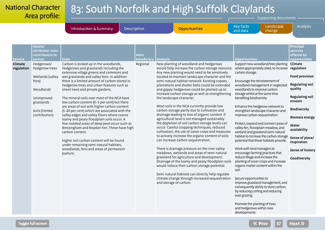
Service
Assets/attributes: main contributors to service State
Main beneficiary Analysis Opportunities
Principal services offered by opportunities
Climate regulation
Hedgerows/ hedgerow trees Wetlands (valley fens) Woodlands Unimproved grasslands Soils (limited contribution)
Carbon is locked up in the woodlands, hedgerows and grasslands including the extensive village greens and commons and wet grasslands and valley fens. In addition there is a limited amount of carbon stored in hedgerow trees and urban features such as street trees and private gardens. The mineral soils over most of the NCA have low carbon content (0–5 per cent) but there are areas of soil with higher carbon content (5–20 per cent) which are associated with the valley edges and valley floors where coarse loamy and peaty floodplain soils occur. A few isolated areas of deep peat occur such as Bressingham and Roydon Fen. These have high carbon content. Higher soil carbon content will be found under remaining semi-natural habitats, woodlands, fens and areas of permanent pasture.
Regional New planting of woodland and hedgerows would help increase the carbon storage resource. Any new planting would need to be sensitively located to maintain landscape character and the semi-natural habitat network. Existing copses, plantations and shelter belts could be extended and gappy hedgerows could be planted up to increase carbon storage as well as strengthening the landscape character.
Most soils in the NCA currently provide low carbon storage partly due to cultivation and drainage leading to loss of organic content. If agricultural land is not managed sustainably the depletion of soil carbon storage levels can occur. Careful cropping techniques, reduced cultivation, the use of cover crops and measures to actively increase the organic content of soils can increase carbon sequestration. There is drainage pressure on the river valley meadows, wetlands and areas of semi-natural grassland for agriculture and development. Drainage of the loamy and peaty floodplain soils would reduce their carbon storage potential. Semi-natural habitats can directly help regulate climate change through increased sequestration and storage of carbon.
Support new woodland/tree planting where appropriately sited, to increase carbon storage. Encourage the reinstatement of woodland management in neglected woodlands to improve carbon storage whilst at the same time benefiting biodiversity. Enhance the hedgerow network to strengthen landscape character and improve carbon sequestration. Protect, expand and connect areas of valley fen, floodplain meadow, and wetland and grassland semi-natural habitat to increase the carbon storage potential that these habitats provide.
Work with land managers to encourage farming practices that reduce tillage and increase the planting of cover crops and increase organic matter content within the soil. Secure opportunities to improve grassland management, and consequently ability to store carbon, by reducing cutting and reducing over grazing. Promote the planting of trees and hedgerows within new developments.
Climate regulation
Food provision
Regulating soil quality
Regulating soil erosion
Biodiversity
Biomass energy
Water availability
Sense of place/ inspiration
Sense of history
Geodiversity
57
83: South Norfolk and High Suffolk ClaylandsSupporting documents
National CharacterArea profile:

Service
Assets/attributes: main contributors to service State
Main beneficiary Analysis Opportunities
Principal services offered by opportunities
Regulating water quality
Aquifers Streams and rivers Wetlands Woodlands Vegetated slopes Geomorphology
The groundwater chemical status is generally good. The percentage of rivers assessed as having good or high biological status is 27 per cent in this NCA. The percentage assessed as having good chemical status is 29 per cent. Groundwater is used for public water supply, industry and agriculture across the NCA and is under significant pressure from diffuse pollution, principally nitrates, phosphates, herbicides and pesticides. Many of the rivers are impacted by drought and periods of low flows, which is reflected in the dissolved oxygen levels measured in some of the rivers dropping to low levels. Despite this, some are still able to support a reasonable cyprinid population dominated by roach, bream, dace and chub. All of the NCA is a nitrate vulnerable zone. The catchments of all the major rivers in the NCA are Catchment Sensitive Farming priority catchments due to high concentrations of both nitrate and phosphate.
Regional Poor water quality is associated with reduced water levels and excess nitrates and phosphates, both of which can have detrimental impacts on the ecology of surface water bodies by reducing the amount of available oxygen within the water, which in turn reduces the diversity of aquatic plants, invertebrates and fish.
An excess of nitrates and phosphates is often associated with agricultural applications, outdoor pig farming and sedimentation from soil erosion. Increasing population densities within towns, such as Beccles, Diss and Wymondham, can also increases pressure on water quality through discharges from sewage treatment works and diffuse pollution from industrial processes and surface water drains.
Urban growth and regeneration will increase demands on the water resource but also present opportunities for improvements to the water environment, for example through sustainable urban drainage schemes.
Semi-natural habitats play an important role in filtering surface water run-off before it enters watercourses. Wetlands such as the valley fens are a good example, but tree lines, woodlands, hedgerows and grass verges can also contribute to reducing the levels of chemicals entering water systems.
Restoration and creation of low-input unimproved grasslands within river catchments can help to improve the water quality in both rivers and underground aquifers.
Enhanced land management through environmental stewardship schemes (for example, an increase in buffer strips along water courses) can help prevent deterioration in water quality caused by high nutrient levels.
Work with partners and land managers to implement catchment-wide water management plans to ensure a coordinated approach to reducing the impacts of pollution.
Improve the sustainable use of water by employing sympathetic land management practices which reduce the demand for ground water for agriculture to maintain water levels in rivers and valley fens.
Encourage agricultural practices that minimise soil erosion from land at risk of generating diffuse pollution in the catchments, for example protecting grassland margins on slopes. Also work with land managers to ensure the use of fertiliser and pesticide is sustainable and associated with good in–field analysis to reduce diffuse pollution.
Ensure local development plans include the sustainable management of water resources and promote measures to reduce adverse impacts on water quality in the future, including the use of sustainable drainage systems, sewage treatment options and reducing nutrients from diffuse pollution.
Seek to increase grassland strips along field drains and watercourses to capture sediment and nutrients.
Create buffer areas between nutrient input and sensitive riparian habitats, areas high in biodiversity and watercourses.
Regulating water quality
Biodiversity
Geodiversity
Sense of place/ inspiration
Recreation
58
83: South Norfolk and High Suffolk ClaylandsSupporting documents
National CharacterArea profile:

Service
Assets/attributes: main contributors to service State
Main beneficiary Analysis Opportunities
Principal services offered by opportunities
Regulating water flow
Soils
Topography
Rivers Floodplains Wetlands Woodlands
The underlying permeable bedrock geology is mainly overtopped by less permeable glacial till, which reduces the infiltration of rainfall in to the soil. The headwaters of the rivers are located on high ground and steep sections of the valley sides mean that rainwater can quickly runoff the land into the streams and rivers, meaning there is a greater risk from surface water flooding in these areas.
Many of the rivers have had their profiles engineered to assist drainage. In places this has prevented them from functioning naturally and being able to spread out on to their adjacent floodplains at times of high flow level.
The river floodplains are generally undeveloped and are used for farming (grazing and arable use). Semi-natural habitats also occur on the floodplain and include areas of riparian vegetation, fen and woodland including wet woodland.
There is low risk to people and property from fluvial flooding in this NCA. The risk is predominantly located in small settlements and isolated areas scattered along the river corridors. The towns or villages with more than 25 properties at risk from river flooding are Bungay, Debenham, Thornham Magna, Hales, Framlingham and Halesworth.
Flooding can be caused further downstream in the neighbouring NCAs. The River Waveney and the River Chet flow into the southern part of The Broads NCA, while the Deben, Alde and Blythe flow into the Suffolk Coast and Heaths NCA. These rivers become tidal within these neighbouring NCAs.
Regional Increased rain fall due to climate change and further development resulting in increased run-off from hard surfaces are likely to increase the flood risk for some settlements located in the river valleys in the future. This relates to settlements both within the NCA and in neighbouring NCAs. The use of sustainable urban drainage systems within developed areas can help reduce these aspects. Where floodplains have been drained, agriculturally improved or developed, their flood water storage capacity and wetland interest is often lost. Increasing the continuity between rivers and their floodplain can help reduce the likelihood of flooding in settlements and improve wetland and aquatic habitats. The creation of flood storage lagoons and encouraging flood compatible land uses can help to alleviate some pressure. These measures help store water during high rainfall events, easing the flood risk on local communities as well as those downstream in the neighbouring NCAs. Semi-natural habitats including fens, wetlands, riparian vegetation help to slow the flow of water entering the main river channels, aiding infiltration to the aquifer and storing water within the system, helping to reduce flood risk further downstream. Woodland and hedgerow planting can also help reduce levels of rapid run-off on sloping land and so help to regulate water flow. Semi-natural vegetation will also help trap sediment from land run off which would otherwise enter the watercourses. A build-up of sediment would over time reduce the flow capacity of the rivers.
Seek opportunities to restore a more naturally functioning floodplain and river morphology by reducing bank and channel maintenance to help naturalise rivers and improve the flow between the river and its floodplain, where this does not increase the risk of flooding to property.
Investigate changes in land use and the development of sustainable farming practices and environmental enhancement to mitigate an increase in flooding in the future.
In existing settlements and new developments, promote sustainable drainage and increased use of semi-natural habitats and permeable surfacing to reduce run-off and increase water filtration; slowing water entering the system.
Secure opportunities to expand or create areas of semi-natural habitats such as wet grassland, woodlands (particularly wet woodlands), floodplain grazing marshes and reed beds to increase soil infiltration and reduce the sedimentation of watercourses thereby helping to alleviate flood risk.
Seek appropriate opportunities for flood storage in locations where people and property are not at risk, improving the flow between the river and its floodplain and so improving wetland and aquatic habitats.
Regulating water flow
Water availability
Regulating water quality
Pollination
Pest regulation
Sense of place/ inspiration
Sense of history
Tranquillity
Biodiversity
Geodiversity
59
83: South Norfolk and High Suffolk ClaylandsSupporting documents
National CharacterArea profile:

Service
Assets/attributes: main contributors to service State
Main beneficiary Analysis Opportunities
Principal services offered by opportunities
Regulating soil quality
Moderately fertile loamy clayey (mostly Grades 2 and 3) soils Semi-natural habitats
The till (boulder clay) gives rise to typical stagnogley soils on the plateau which, while difficult to work when wet, are extremely fertile if drained. In places, valley floor soils are deep peat, associated with clayey over sandy soils. Deep well drained sandy and coarse loamy soils occur on the valley sides and there are some isolated areas of permeable calcareous clayey soils. A distinct and isolated area of peat occurs to the west of Diss and corresponds with Bressingham and Roydon Fen.
Local The high agricultural grade soils are important for food production. Changing management practices to reduce damage to soil quality could provide increases in food production in the long term. Improvements in soil quality will reduce negative impacts from farming through reduction in run-off pollution; this will improve water quality and biodiversity. Maintenance of good soil structure aids water infiltration and recharge of the underlying groundwater aquifers. Soil compaction, poaching and loss of structural cohesion on loamy and clayey soils with impeded drainage can become problematic, increasing the vulnerability to run-off under high precipitation conditions. Once these soils are compacted they are surprisingly difficult to rectify. Minimum tillage such as direct drilling can work well in some of these soils, such as those in the north and west of the area. Where organic matter is low increasing organic matter inputs or use of grass leys can help improve soil structure.
Adopt sustainable cultivation practices that increase organic content of soils, such as introducing fallow cropping into rotations, direct drill and grass leys. Avoid overstocking or machinery use where and when it would lead to the compaction of vulnerable soils. Promote agri-environment schemes at targeted sites to deliver resource protection gains by working with farmers to retain soil quality and ensure a viable long-term future for agriculture in the area.
Regulating soil quality Food provision Regulating soil erosion Regulating water quality Climate regulation Biodiversity Geodiversity Sense of place/ inspiration
60
83: South Norfolk and High Suffolk ClaylandsSupporting documents
National CharacterArea profile:

Service
Assets/attributes: main contributors to service State
Main beneficiary Analysis Opportunities
Principal services offered by opportunities
Regulating soil erosion
Semi-natural habitats Hedgerows and trees Woodlands
The typical stagnogley soils on the plateau and the well-drained sandy and coarse loamy soils on the valley sides are at risk of erosion from run-off where land is sloping.
The clayey soils with impeded drainage are prone to compaction and capping/slaking which can be caused by machinery or livestock if accessed when wet. This increases the risks of soil erosion by surface water run-off, especially on steeper slopes of the valley sides. In the south-west of the area close to the border with The Brecks there are areas of free draining sandy soils that have an enhanced risk of wind erosion and run off where cultivated or bare soil is exposed, for example, where outdoor pig farming takes place.
Loamy, clayey and peaty flood plain soils with naturally high groundwater are at low risk of soil erosion, except when allowed to dry out. The catchments of all the major rivers in the NCA are Catchment Sensitive Farming Priority Catchments.
Local Erosion is exacerbated where organic matter levels are low after continuous arable cultivation. This can be a problem on parts of the clay arable plateau, especially on sloping ground.
The use of low ground pressure vehicles on soils with impeded drainage can help to reduce the risk of soil compaction and capping/slacking which can lead to increased levels of soil erosion from water run-off. Where these soils are used for grazing reduced stocking rates can also help prevent soil compaction and erosion. Where there is potential for wind erosion on some coarse textured cultivated soils in the south-west of the area, the planting of hedgerows and shelterbelts can help reduce the vulnerability of these areas. Appropriate soil management can reduce risks of soil erosion (for example, careful timing of cultivations and maintenance of vegetation cover).
Work with land managers to ensure that soils with impeded drainage are not compacted, by encouraging low stocking rates, the use of low ground pressure vehicles and by encouraging the conversion to semi natural habitat of land at risk of compaction. Encourage the uptake of agri-environment and catchment sensitive farming schemes to support these measures. Encourage the planting of hedgerows in areas where wind erosion occurs. This will also reduce soil erosion caused by overland run-off. On free draining, fragile soils encourage agricultural practices that utilise minimum cultivation techniques and avoid leaving surfaces exposed (for example, by introducing and incorporating green cover crops, fallow rotations, overwintering stubble, or reversion to permanent grassland). Encourage agricultural practices that retain cover and build up organic matter especially on free draining soils.
Regulating soil erosion
Food provision
Regulating soil quality
Regulating water quality
Geodiversity
61
83: South Norfolk and High Suffolk ClaylandsSupporting documents
National CharacterArea profile:

Service
Assets/attributes: main contributors to service State
Main beneficiary Analysis Opportunities
Principal services offered by opportunities
Pollination Semi-natural habitats, especially hedgerows and grasslands/field margins Woodlands and orchards
Semi-natural habitats within the NCA including plateau woodlands, valley fens and flower rich grasslands, commons and greens support a variety of pollinators which are an essential component of agricultural production. Networks of interstitial habitats such as hedgerows, farm track edges and ditches are also key sources of both pollen and nectar for insects that pollinate commercial arable crops such as field beans. The ancient countryside with its network of interstitial habitats is generally good for supporting a range of pollinators although these networks are more limited across the core arable areas of the clay plateau in the centre of the NCA.
Local Pollinating insects are generally supported by a range of semi-natural habitats, in particular species rich grasslands in the river valleys. Increases in habitat for pollinators such as creation of flower rich pasture in the river valleys, planting hedgerows and field margins, will increase the value of this service to agriculture. The degree to which crops rely on insect pollinators depends on both species and cultivar. Improving good networks of pollinator habitat such as field margins on the plateau will assist pollination of crops (eg field beans) aiding food production. A strong pollinator population supports production of a wider variety of food products. The loss of semi natural habitats has reduced the population of pollinators within the NCA.
Extend semi-natural habitat mosaics that provide early and late nectar sources for pollinators that in turn will pollinate commercial food crops, particularly those grown on the plateau. Work with land managers to further protect and improve the management of areas of semi-natural habitat, buffering existing habitats where possible, to increase hibernation sites for pollinating insects. Work with land managers and use schemes such as Environmental Stewardship to increase pollen and nectar resources in arable areas through the creation of species-rich grass margins and bespoke pollen and nectar strips, creating and connecting links with other semi-natural habitats.
Pollination
Biodiversity Sense of place/ inspiration Food provision
62
83: South Norfolk and High Suffolk ClaylandsSupporting documents
National CharacterArea profile:

Service
Assets/attributes: main contributors to service State
Main beneficiary Analysis Opportunities
Principal services offered by opportunities
Pest regulation
Semi-natural habitat:
Woodland
Fen
Grassland
Hedgerows/ grass margins
Interstitial habitats such as hedgerows, farm track edges and ditches and semi natural habitats including plateau woodlands, grassland and fen, provide important over-wintering habitats for beneficial predatory invertebrates such as ground and rove beetles, which can regulate the populations of pests such as aphids. The ancient countryside with its network of interstitial habitats is generally good for supporting pest regulation, although these networks are more limited across the core arable areas of the clay plateau in the centre of the NCA.
Local The use of insecticides and herbicides in fields and especially around field edges removes a food source for ground-nesting birds such as grey partridge and skylark that can help reduce pest numbers through natural predation. Integrated pest management approaches may in some cases remove the requirement for chemical intervention, although evidence of the efficiency of these methods is not conclusive. Financial support for farmers channelled through agri-environment schemes can assist with increasing the network of these habitats in arable areas.
Encourage land management which reduces insecticide use around the edge of crops, to increase insect numbers that benefit predatory insects, birds and small mammals.
Seek to increase diversity of structure and composition within semi-natural habitats to support a variety of species and encourage land management which reduces use of herbicide to encourage wildflowers and support a greater abundance of insects. Increase field margins, species rich hedgerows, and the diversity of structure and composition within semi-natural habitats to encourage a network of habitats for pest regulating species close to areas of agricultural production.
Pest regulation
Pollination
Biodiversity
Food provision
Sense of place/ inspiration
63
83: South Norfolk and High Suffolk ClaylandsSupporting documents
National CharacterArea profile:

Service
Assets/attributes: main contributors to service State
Main beneficiary Analysis Opportunities
Principal services offered by opportunities
Sense of place/ inspiration
Geology and soils Semi-natural habitats Topographic variation River valleys Scattered ancient woodlands Hedgerows Field patterns Traditional built environment
Network of lanes Expansive views, big skies
The underlying geology (chalk, sand and gravels and clay), underpins a mix of semi-natural habitat types that provide local distinctiveness (eg semi-natural woodland, valley fens and wet heath and floodplain grassland). The chalky clay soils give a calcareous feel to the vegetation. Extensive large-scale views across the plateau provide a sense of openness. Undulating gently sloping small river valley topography provides a small-scale intimate character that contrasts with the open plateau. Tranquil river valleys provide a strongly rural sense of place. Woodlands and copses linked by hedgerows provide wooded horizons. Small to medium scale medieval fields patterns are overlain in places by large scale, modern field patterns, contributing to a feeling of openness. Small medieval market towns and villages are often developed around village greens or commons.
Vernacular building tradition of timber framed buildings with painted render, red brick, clay tiles and longstraw thatching. Saxo Norman and Medieval churches with knapped flint. Senses of inspiration are associated with the area’s light quality, open skies, historic features and rural tranquillity.
Regional Further degradation of hedgerow boundaries can open up the valley sides creating a more monotonous landscape and the progressive loss of visual distinction. The local rural vernacular and market town quality and their compact and contained character can be eroded by residential extensions or linear development along the major roads. Land is increasingly being sold in smaller plots for non-agricultural use. While individual incremental changes have minimal impact, cumulatively, the landscape of the area as a whole can be altered. The growth in micro-generation, particularly small scale wind and solar photo voltaic installations can have a significant landscape impact that weaken the sense of place.
Conserve the rural mosaic of landscapes and semi-natural habitats that are characteristic of the NCA and essential for the feelings of place and inspiration. Retain the contrasts within the local landscape character, between the plateau and river valleys. Ensure the character of the area’s settlements is maintained and that new development does not weaken the rural sense of place. Strengthen the historic character of the landscape, through protecting and enhancing the wooded elements by bringing neglected woodlands into appropriate management and replanting hedgerows and hedgerow trees. Create new woodland as appropriate to screen new development and provide habitat and green infrastructure benefits. Improve understanding of the landscape, its history and functions including its agricultural and wildlife values. Continued over...
Sense of place/ inspiration
Sense of history
Recreation Geodiversity
64
83: South Norfolk and High Suffolk ClaylandsSupporting documents
National CharacterArea profile:

Service
Assets/attributes: main contributors to service State
Main beneficiary Analysis Opportunities
Principal services offered by opportunities
Sense of place/ inspiration continued
... continued from previous.
Conserve and enhance the local rural vernacular and character of the compact market towns and small-scale vernacular settlements, through the spatial planning process and through the use of specific design guidance to ensure that new developments, including small scale wind and solar photo voltaic installations, fit in with the landscape character to retain local distinctiveness. Ensure that where conversion or change of use of rural farm buildings is considered, developments reflect local building style, resist suburbanisation and do not contribute to incremental new development in the open countryside Retain wide views and the experience of big skies and maintain open views to churches and the valley crest skyline.. Maintain pasture and grazing (cattle and sheep) in the valley and conserve the mixed arable and pastoral character of the valley sides to support the valley’s strong sense of place.
65
83: South Norfolk and High Suffolk ClaylandsSupporting documents
National CharacterArea profile:

Service
Assets/attributes: main contributors to service State
Main beneficiary Analysis Opportunities
Principal services offered by opportunities
Sense of history
Geology and soils
Archaeology
Rivers
Field patterns
Ancient woodlands and hedgerows
Medieval deer parks
Settlement pattern and market towns
Greens and commons
Moats
Barns
Windmills and watermills
Built environment and building vernacular
Country houses and parkland
Second World War airfields and pillboxes
The underlying Chalk and gravel and sand deposits provide a geological record and provide an archive of past environmental and climatic change that may help inform our understanding of the impacts of future climate change. These deposits also provide a context for the archaeology found within this NCA such as the Palaeolithic finds. The rich heritage and long history of settlement includes Roman sites, medieval villages and castles, Saxo-Norman round tower churches, medieval churches, moated farmsteads and barns and many Grade 1 listed market town buildings, provide a historic insight to what was one of the most densely populated parts of England in medieval times. The dispersed settlement pattern of small villages around commons and greens, isolated hamlets and market towns provide a record of human settlement in this rural part of the country. Numerous windmills (for example, Saxted, Pakenham and Billingford mills) illustrate the deeply rooted traditional agricultural economy of the NCA. Ancient surviving sinuous hedgerows and boundaries are representative of the pattern of medieval fields and holdings and along with the road and path network provide the backbone of the historic landscape. The ancient wooded landscape demonstrates aspects of medieval enclosure and the impact of 20th-century field rationalisation. Continued over...
Regional Maintaining, conserving and enhancing the sense of history would achieve a wider understanding of the importance of the NCA. Increased opportunities to interact with the history of the NCA may have potential to increase the sense of history. This may lead to increased recreation and tourism although management would be needed to ensure this is sustainable and does not have a negative impact on the assets themselves. The reinforced sense of history could contribute strongly to sense of place in the landscape. The small ancient woodland remnants are important both for landscape character as well as biodiversity. They are a historic record of a previously more wooded landscape. Loss of traditional village patterns through new infill development, barn conversions and the use of non-traditional building materials in renovation work, can lead to gradual erosion of historical assets and the quality and distinctiveness of the built environment.
Provide a sense of history through promotion of the archaeological record and the value of geological sites in preserving a record of past landscapes. Encourage the positive management of earthworks such as moated sites where they have become overgrown or silted, reducing their visibility in the landscape. This will provide opportunities for education. Conserve, enhance and promote the historic evidence of past human settlement, historic landscapes and links between historical sites, archaeological evidence and the geological interest of the area, to achieve a wider understanding of the importance of the NCA. Provide interpretation and education facilities to explain the heritage assets in the area. Protect, maintain and restore historic buildings that are assessed as a priority in the region. Protect the sensitivity of historic landscape/ landmark features and their setting such as windmills and watermills and round churches, by ensuring that new development is sensitively sited. Continued over...
Sense of history
Tranquillity Recreation Sense of place/ inspiration Geodiversity
66
83: South Norfolk and High Suffolk ClaylandsSupporting documents
National CharacterArea profile:

Service
Assets/attributes: main contributors to service State
Main beneficiary Analysis Opportunities
Principal services offered by opportunities
Sense of history continued
...continued from previous.
Country houses and landscape parklands provide a sense of past wealth (for example, Heveningham Hall and Helmingham Hall). Second World War runway strips, hard standings, hangars, pillboxes and barracks buildings dot the landscape illustrating the areas wartime importance (for example, Parham and Seething).
...continued from previous.
Increase the sense of history by protecting the character and historic resource of agricultural areas and registered parks and gardens for the cultural history they contribute to the landscape character. Strengthen the historic settlement patterns where new development is proposed. Where the restoration of historic features is proposed encourage the use of local materials and local vernacular styles.
67
83: South Norfolk and High Suffolk ClaylandsSupporting documents
National CharacterArea profile:

Service
Assets/attributes: main contributors to service State
Main beneficiary Analysis Opportunities
Principal services offered by opportunities
Tranquillity Farmland Fens Woodlands River valleys
72 per cent of the NCA is classified as undisturbed. The agricultural clay plateau area has high levels of tranquillity due its remoteness from main transport routes and large settlements. The sense of remoteness is enhanced by the dispersed settlement pattern, and tranquil river valleys.
Undisturbed areas have decreased from 98 per cent in the 1960s to 72 per cent in 2007. Lower levels of tranquillity are associated with main roads including the A11, A12, A14, A140 and A143.
Local The tranquil, intact character of the Waveney Valley is especially vulnerable to development associated with transport corridors through the area (A1066 and A143). Inward migration to the towns in the area, particularly the market towns close to the main transport routes, can result in further urban expansion with increased housing, infrastructure and traffic levels. This in turn can reduce tranquillity levels, within the area over time, including the dark night skies.
Ensure main roads along the valley sides (A1066 and A143) do not provide a catalyst for inappropriate linear development. Protect the intact rural character, for example from large-scale development and road lighting schemes, which could impinge on the tranquil, peaceful character. Increase tranquillity by conserving and extending areas of semi-natural habitat, particularly woodlands and hedgerows to benefits wildlife and people. Explore how tranquil areas can be mapped and retained. Encourage new housing and other developments to be of a high quality to meet design and sustainability requirements, particularly with regard noise and lighting in rural areas. Use specific design guidance to retain these qualities. Ensure that local development frameworks recognise the importance of conserving and enhancing tranquillity to help reduce negative impacts from new developments.
Tranquillity
Recreation
Sense of place/ inspiration
Sense of history
Biodiversity
Geodiversity
68
83: South Norfolk and High Suffolk ClaylandsSupporting documents
National CharacterArea profile:

Service
Assets/attributes: main contributors to service State
Main beneficiary Analysis Opportunities
Principal services offered by opportunities
Recreation Public rights of way network
Long distance footpaths Rivers Historic features Airfield museums.
National Nature Reserves
The NCA attracts a diversity of visitors including local ramblers, cyclists, artists, anglers, bird-watchers, day trippers and tourists.
Recreation is supported by the gentle topography of the landscape and 2,978 km of public rights of way, although only 0.9 per cent (1,873 ha) of the NCA is classified as being publically accessible.
Diss is the start of the popular Boudicca Way walking path to Norwich, which goes past the old Roman town of Venta Icenorum. The Angles Way follows the county boundary between Norfolk and Suffolk and runs for 149 km linking Great Yarmouth (NCA 79) through to Thetford (NCA 85). The Mid Suffolk footpath runs for 32 km linking Stowmarket in the south with the small village of Hoxne at its northern end. The footpath/ bridleway access network is fragmented and under-used; however the quiet lanes are well suited to cycling and horse riding.
Rivers such as the Waveney, provide recreational resources for low impact activities, for example, canoeing and coarse fishing.
Historic features that are open to the public, for example, Pakenham Mill, Framlingham Castle, Helmingham Hall and Parham airfield museum, often host special themed open days and events that allow the public close access to local historical features.
National Nature Reserves (NNRs) such as Redgrave and Lopham Fen are open to the public allowing people to experience the diverse wildlife and these ancient and unique landscape features.
Regional Recreation in the area is on the increase as the population of the south east increases. Increased numbers of people visiting popular locations such as the historic market towns could cause adverse impacts to local residents and increasing pressure on local resources.
As part of the Greater Norwich Green Infrastructure Strategy, the opportunities for new green links from South Norwich to Mulbarton and Diss, and from South Norwich to East of Diss have been identified. Increasing recreational access to local areas, particularly in the summer months, can impact on tranquillity. An increase in horse riding has led to a slow growth in equestrian grazing leading to the development of some ‘pony paddocks’ that can bring intrusive infrastructure and little biodiversity gain.
Improve people’s understanding of landscapes through educational access, providing interpretation of local features at key sites. Support well planned green infrastructure as identified in the Greater Norwich Green Infrastructure Strategy, to provide sustainable access routes. Increase people’s engagement with the natural environment to further benefit physical and mental health, by developing improved public access.
Recreation
Biodiversity
Geodiversity
Tranquillity
Regulating water quality
Regulating soil erosion
Sense of place/ inspiration
Water availability
69
83: South Norfolk and High Suffolk ClaylandsSupporting documents
National CharacterArea profile:

Service
Assets/attributes: main contributors to service State
Main beneficiary Analysis Opportunities
Principal services offered by opportunities
Biodiversity Semi-natural priority habitats Nationally and internationally designated sites Hedgerows Rivers Agricultural land Valley fens and dry heaths Ponds Semi-natural ancient woodland Remnant parkland Grassland, greens and commons
Local nature Reserves (LNRs)
Land covered by international nature conservation designations (SPAs and Ramsar) totals 215 ha, less than 1 per cent of the total land area. Designations include: Redgrave and South Lopham Fens Ramsar; Broadland Ramsar; Broadland SPA; Waveney and Little Ouse Valley Fens SAC; Norfolk Valley Fens SAC and Dew’s Ponds SAC.
NNRs and SSSI total 1,113 ha or less than 1 per cent of the total land area. There is 1 NNR - Redgrave and Lopham Fen.
There are 54 SSSI. In 2011 over 80 per cent of the SSSI area was in either favourable or recovering condition. 19 per cent was in ‘unfavourable’ condition.
469 LNRs cover 3,549 ha (2 per cent of the NCA).
Norfolk is considered to have the best representation of fen types in England, particularly valley head and floodplain fens. Numerous rich-fens of the valley head type are found both in High Suffolk and South Norfolk in the Little Ouse and Waveney valleys (for example, Roydon Fen and Redgrave and Lopham Fen). Fen vegetation has declined significantly in the last century, mainly as a result of neglect, desiccation, cultivation and enrichment. Fens are now a priority habitat. They support a particularly diverse array of plants and animals, including: over 250 plant species, some of which cannot be found anywhere else in lowland England.
The area has one of the highest densities of ponds in the UK that provide a stronghold for great-crested newt.
Continued over....
National There is fragmentation of biodiversity habitats across the NCA. Important semi-natural habitats are designated, such as the Waveney and Little Ouse Valley Fens SAC, although the importance of the agricultural land for biodiversity is under-represented. Tailored conservation support for agricultural businesses, delivered through agri-environment schemes can help support on-farm biodiversity outside of protected sites.
Woodlands, especially ancient woodlands, as well as river valley habitats are core areas for biodiversity. Ancient hedgerows function as corridors linking these often fragmented habitats. Improving the network of linking features such as hedgerows can benefit biodiversity. Many types of woodland are undermanaged, which has led to a decline in their importance for biodiversity. Improving or reinstating management practices such as coppicing can support biodiversity.
Habitats such as fen, heath and wet woodland are sensitive to development, fragmentation and changes in water level/ quality.
Valley fens (Waveney and Little Ouse Valley Fens SAC; Norfolk Valley Fens SAC) rely on a pure supply of spring water from the underlying chalk rock, which has given them their unique characteristic vegetation and associated animal communities. Reducing levels of run-off into water courses through the uptake of Catchment Sensitive Farming schemes can limit the impacts of diffuse pollution of fens and watercourses, supporting the diversity of aquatic plants, invertebrates and fish.
Continued over....
Facilitate agricultural businesses to undertake more tailored conservation management, including the restoration of field ponds, improving the understanding of the area’s ecology and requirements for specialist species, through support provided by agri-environment schemes. Seek opportunities to increase woodland management where this will benefit biodiversity as well as timber provision and sense of place. Support the creation and expansion of native woodlands in connection with existing woodland and copses to improve the ecological networks and provide increased benefits for biodiversity. Encourage different remedies to improve water quality (for example increasing on-farm water storage to reduce water abstraction levels, increasing flow rates and water levels in rivers and continue to make improvement to waste water treatment works), to benefit aquatic biodiversity. Continued over....
Biodiversity
Geodiversity
Sense of place/ inspiration
Sense of history
Recreation
Pollination
Pest regulation
Food provision
Tranquillity
70
83: South Norfolk and High Suffolk ClaylandsSupporting documents
National CharacterArea profile:

Service
Assets/attributes: main contributors to service State
Main beneficiary Analysis Opportunities
Principal services offered by opportunities
Biodiversity continued
... continued from previous.
Farmland field habitats support skylark, grey partridge, corn bunting, cornflower and brown hare.
... continued from previous.
Fens are dynamic, semi-natural systems and management is generally needed to maintain open fen communities and their related species richness. Without appropriate management and water supply, natural processes will lead to scrub and woodland forming.
... continued from previous.
Conserve and enhance through appropriate management the diversity of habitats (for example, valley fen, heath, grassland on common land and wet woodland), to prevent deterioration of vegetation and scrub invasion to maintain the favourable condition of these habitats.
Promote the sustainable management of fen ‘meadow’ areas, cutting annually to support a wide variety of mosses, sedges, rushes and grasses as well as uncommon flowers.
Appropriately manage visitors to wetland reserves (for example, Redgrave and South Lopham Fens) by the use of spatial and temporal zoning of activities, screening at sensitive locations and visitor management policies that reflect the site specific conditions and the species potentially affected.
Improve the health and resilience of the habitat networks and associated biodiversity to safeguard against the consequential impacts of climate change.
Raise awareness and improve understanding and enjoyment of the sensitive habitats and wildlife by investing in high-quality infrastructure and interpretation.
Raise awareness of the role of geodiversity in underpinning biodiversity.
71
83: South Norfolk and High Suffolk ClaylandsSupporting documents
National CharacterArea profile:

Service
Assets/attributes: main contributors to service State
Main beneficiary Analysis Opportunities
Principal services offered by opportunities
Geodiversity River valley exposures Quarry exposures Geomorphology Archaeology
Geodiversity underpins much of the characteristic landscape features within this NCA. The principal mineral resource within the NCA is sand and gravel. Particular concentrations occur in the river valleys such as the Waveney Valley. Glacial till and underlying gravel and sand deposits provide a geological record and an archive of past environmental and climatic change that may help inform our understanding of the impacts of future climate change. These deposits also provide a context for the archaeology found within this NCA such as the Palaeolithic finds. There are 4 geological SSSI and 13 Local Geological Sites within the NCA.
Regional The valley’s geodiversity includes Cretaceous, Palaeocene, Eocene, Pliocene and Pleistocene geology, and also Pleistocene and Holocene landforms. Sand and gravel is exploited by quarrying for use in the construction industry. The restoration of river valley sand and gravel quarries provides opportunities for geodiversity, wetland biodiversity as well as recreation. Disused gravel pits continue to yield geological information and examples of relic and active landform features.
Use geological sites as a community educational tool, emphasising the integral role of geodiversity in underpinning the landscape character of the NCA. Ensure that geodiversity sites continue to be protected and conserved and are still available for research. Maintain and enhance the geological and geomorphological resource through implementation of the Norfolk/Suffolk Geodiversity Action Plan, specifically through maintenance of natural fluvial processes, together with the development of local geological conservation strategies and assessment of educational/research value of sites. Identify opportunities for geodiversity (and biodiversity) enhancement, which might develop through the reinstatement of semi-natural habitats. Ensure that sand and gravel extraction sites are restored to contribute to local landscape character and exploit geodiversity opportunities and enhance biodiversity opportunities, providing improved access where possible.
Geodiversity
Biodiversity
Recreation
Sense of place/ inspiration
Sense of history
72
83: South Norfolk and High Suffolk ClaylandsSupporting documents
National CharacterArea profile:

73
Natural England is here to secure a healthy natural environment for people to enjoy, where wildlife is protected and England’s traditional landscapes are safeguarded for future generations.
Catalogue Code: NE544ISBN: 978-1-78367-104-5
Should an alternative format of this publication be required, please contact our enquiries line for more information: 0845 600 3078 or email [email protected]
www.naturalengland.org.uk
83: South Norfolk and High Suffolk ClaylandsSupporting documents
National CharacterArea profile:
Photo creditsFront cover: The farmed landscape in high summer in the southern half of the South Norfolk and High Suffolk Claylands. © Jonathan DixPage 4, 5, 6, 7, 9, 11, 12, 13, 15, 17, 29, 30, 36, 38, 40, 50: © Jonathan DixPage 8: © Philip WatsonPage 10: © Edward Martin
This note/report/publication is published by Natural England under the Open Government Licence - OGLv2.0 for public sector information. You are encouraged to use, and reuse, information subject to certain conditions.
For details of the licence visit www.naturalengland.org.uk/copyright
Natural England images are only available for non commercial purposes. If any other information such as maps or data cannot be used commercially this will be made clear within the note/report/publication.
© Natural England 2014