![[Brochure] shrdc miti](https://static.fdocuments.us/doc/165x107/5590c2921a28ab4d558b4592/brochure-shrdc-miti.jpg)
NASA/GSFC/MITI/ERSDAC/JAROS, and U.S./Japan ASTER … · glaciers that are confined by the rock...
12
525 Glaciers may store water as ice for hundreds or even hundreds of thousands of years before it is released as meltwater into the liq- uid part of the hydrologic system.Yet, glacial ice is not stagnant. It moves slowly but with tremendous energy across the land. Glaciers reshape the landscape by engulfing, eroding, pushing, dragging, carrying, and finally depositing rock debris, often in places far from its original location. Long after glaciers recede from a landscape, glacial landforms remain as a reminder of the energy of the glacial system and as evidence of past climates ( ● Fig. 19.3). Glaciers have not existed on the planet during most of Earth history. However, when a period occurs during which sig- nificant areas of the middle latitudes are covered by glaciers, we call it an ice age. Today, glaciers cover about 10% of Earth’s land surface. Present-day glaciers are found on Greenland, on Antarc- tica, and at high latitudes and high elevations on all continents except Australia. During recent Earth history, from about 2.4 million years ago to about 10,000 years before the present, dur- ing the Pleistocene Epoch, glaciers periodically covered nearly a third of Earth’s land area. Other ice ages occurred in the much more distant geologic past. Types of Glaciers The two major categories of glaciers are alpine and continental. Alpine glaciers exist where the precipitation and temperature conditions required for glacier formation result from high eleva- tion. Alpine glaciers are fed by ice and snow in mountain areas and usually occupy preexisting valleys created by a previous pe- riod of stream erosion. The ice masses flow downslope because of their own weight, that is, due to the force of gravity. Alpine glaciers that are confined by the rock walls of the valley they occupy are valley glaciers ( ● Fig. 19.4). They are known as piedmont glaciers when the ice flows beyond the confines of the valley, spreading out over flatter land. Some alpine glaciers, however, do not reach the valleys below the zone of high peaks. Instead, they occupy distinctive steep-sided, amphitheater-like ● FIGURE 19.2 Glaciers that flow into the sea or a deep lake undergo calving, the process by which large chunks of ice break off and become icebergs in the water. (a) Large icebergs derived from the toe of a glacier on Ellesmere Island, Canada, are visible on this satellite image of Greely Fjord taken in August of 2003. (b) The edge of the Columbia Glacier in Prince William Sound, Alaska, is a source of icebergs in that region. NASA/GSFC/MITI/ERSDAC/JAROS, and U.S./Japan ASTER Science Team USGS/Austin Post (a) (b) ● FIGURE 19.3 Glaciers are powerful geomorphic agents that leave distinctive landform evidence of their previous, widespread existence. This system of trough- shaped valleys, narrow bedrock ridges, and lakes in bowl-shaped depressions lies in the previously glaciated Ruby Mountains of northeastern Nevada. D. Sack TYPES OF GLACIERS
-
Upload
nguyenkiet -
Category
Documents
-
view
217 -
download
4
Transcript of NASA/GSFC/MITI/ERSDAC/JAROS, and U.S./Japan ASTER … · glaciers that are confined by the rock...

525
Glaciers may store water as ice for hundreds or even hundreds of thousands of years before it is released as meltwater into the liq-uid part of the hydrologic system. Yet, glacial ice is not stagnant. It moves slowly but with tremendous energy across the land. Glaciers reshape the landscape by engulfing, eroding, pushing, dragging, carrying, and finally depositing rock debris, often in places far from its original location. Long after glaciers recede from a landscape, glacial landforms remain as a reminder of the energy of the glacial system and as evidence of past climates ( ● Fig. 19.3).
Glaciers have not existed on the planet during most of Earth history. However, when a period occurs during which sig-nificant areas of the middle latitudes are covered by glaciers, we call it an ice age. Today, glaciers cover about 10% of Earth’s land surface. Present-day glaciers are found on Greenland, on Antarc-tica, and at high latitudes and high elevations on all continents except Australia. During recent Earth history, from about 2.4 million years ago to about 10,000 years before the present, dur-ing the Pleistocene Epoch, glaciers periodically covered nearly a third of Earth’s land area. Other ice ages occurred in the much more distant geologic past.
Types of GlaciersThe two major categories of glaciers are alpine and continental. Alpine glaciers exist where the precipitation and temperature conditions required for glacier formation result from high eleva-tion. Alpine glaciers are fed by ice and snow in mountain areas
and usually occupy preexisting valleys created by a previous pe-riod of stream erosion. The ice masses flow downslope because of their own weight, that is, due to the force of gravity. Alpine glaciers that are confined by the rock walls of the valley they occupy are valley glaciers ( ● Fig. 19.4). They are known as piedmont glaciers when the ice flows beyond the confines of the valley, spreading out over flatter land. Some alpine glaciers, however, do not reach the valleys below the zone of high peaks. Instead, they occupy distinctive steep-sided, amphitheater-like
● FIGURE 19.2Glaciers that flow into the sea or a deep lake undergo calving, the process by which large chunks of ice break off and become icebergs in the water. (a) Large icebergs derived from the toe of a glacier on Ellesmere Island, Canada, are visible on this satellite image of Greely Fjord taken in August of 2003. (b) The edge of the Columbia Glacier in Prince William Sound, Alaska, is a source of icebergs in that region.
NAS
A/GS
FC/M
ITI/E
RSDA
C/JA
ROS,
and
U.S
./Jap
an A
STER
Sci
ence
Team
USGS
/Aus
tin P
ost
(a) (b)
● FIGURE 19.3Glaciers are powerful geomorphic agents that leave distinctive landform evidence of their previous, widespread existence. This system of trough-shaped valleys, narrow bedrock ridges, and lakes in bowl-shaped depressions lies in the previously glaciated Ruby Mountains of northeastern Nevada.
D. S
ack
T Y P E S O F G L A C I E R S
55061_19_Ch19_p522_555 pp2.indd 52555061_19_Ch19_p522_555 pp2.indd 525 6/6/08 1:53:34 PM6/6/08 1:53:34 PM

C H A P T E R 1 9 • G L A C I A L S Y S T E M S A N D L A N D F O R M S526
hen we make ice in our freez-ers, clear colorless water turns to relatively clear ice cubes. The
ice cubes may contain some white crystal-line forms and air bubbles, but in general the ice is clear. In nature, the process of making ice is very different from that of an ice maker in a refrigerator-freezer. As snow falls at colder, higher latitudes and elevations, it forms a layer of snow on the surface. Each successive snowfall makes another layer as it piles onto the previous snowpack. The weight of the successive layers of snow creates pressure that com-presses the older layers beneath. Through time, the layers of low-density snow become layers of much denser solid ice. Some of this change is due to compaction,
but pressure also causes some melting and refreezing of the ice. The tempera-ture at which ice melts is 0°C (32°F) at atmospheric pressure, but ice can melt at lower temperatures if it is under enough pressure. Both compaction and pressure melting and refreezing work to reduce the amount of air in the frozen mass and thereby increase the material’s density.
Objects that appear white to the hu-man eye reflect all wavelengths of light with equal intensity, and this is what the hexagonal crystalline structure of snow-flakes does. As the snow strata under great pressure in a glacier become compacted over the years (sometimes hundreds or thousands of years) the ice becomes denser. Basically, under this pressure,
more ice crystals are squeezed into the same volume. As the density of ice in-creases, it reflects increasing amounts of shorter wavelengths of light, which is the blue part of the spectrum. The denser the ice, the bluer it appears. Ice density can be influenced by factors other than time, though, so we must be careful not to as-sume that deeper blue layers in a glacier are necessarily the older layers. For ex-ample, the packing of higher density wet-ter snow as opposed to lower density drier snow can affect the density of specific layers. Nevertheless, what is certain when looking at massive glacial ice accumula-tions in nature, such as in ice caps and ice sheets, is that the ice will appear as shades of blue.
W
G E O G R A P H Y ’ S P H Y S I C A L S C I E N C E P E R S P E C T I V E
Glacial Ice Is Blue!
This iceberg in Antarctica displays very old layers of glacial ice.
NAS
A/Ji
m R
ossi
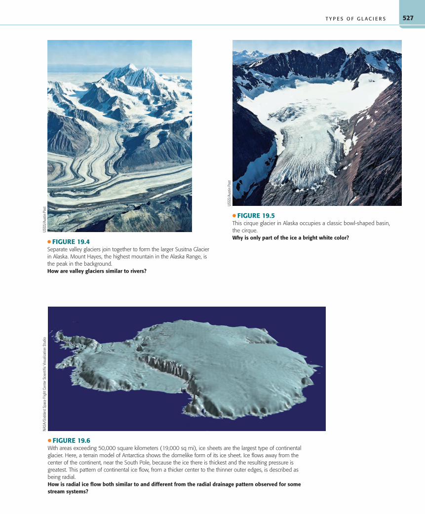
depressions called cirques that are eroded by ice flow at the heads of valleys, and are thus termed cirque glaciers ( ● Fig. 19.5). Cirque glaciers are the smallest type of glacier. Alpine glaciers begin as cirque glaciers at the start of an ice age, expanding into valley glaciers, and perhaps eventually piedmont glaciers as the ice age intensifies. Most cirque glaciers today represent small remnants of previously larger alpine glaciers.
Alpine glaciers created the characteristic rugged scenery of much of the world’s high-mountain regions. Today alpine glaciers are found in the Rockies, the Sierra Nevada, the Cascades, the Olympic Mountains, the Coast Ranges, and numerous Alaskan ranges of North America. They also exist in the Andes, the Alps, the Southern Alps of New Zealand, the Himalayas, the Pamirs, and other high Asian mountain ranges. Small alpine glaciers are
even found at high elevations on tropical mountains in New Guinea and in East Africa on Mounts Kenya and Kilimanjaro. The largest alpine glaciers currently in existence are located in Alaska and the Himalayas, where some reach lengths of more than 100 kilometers (62 mi).
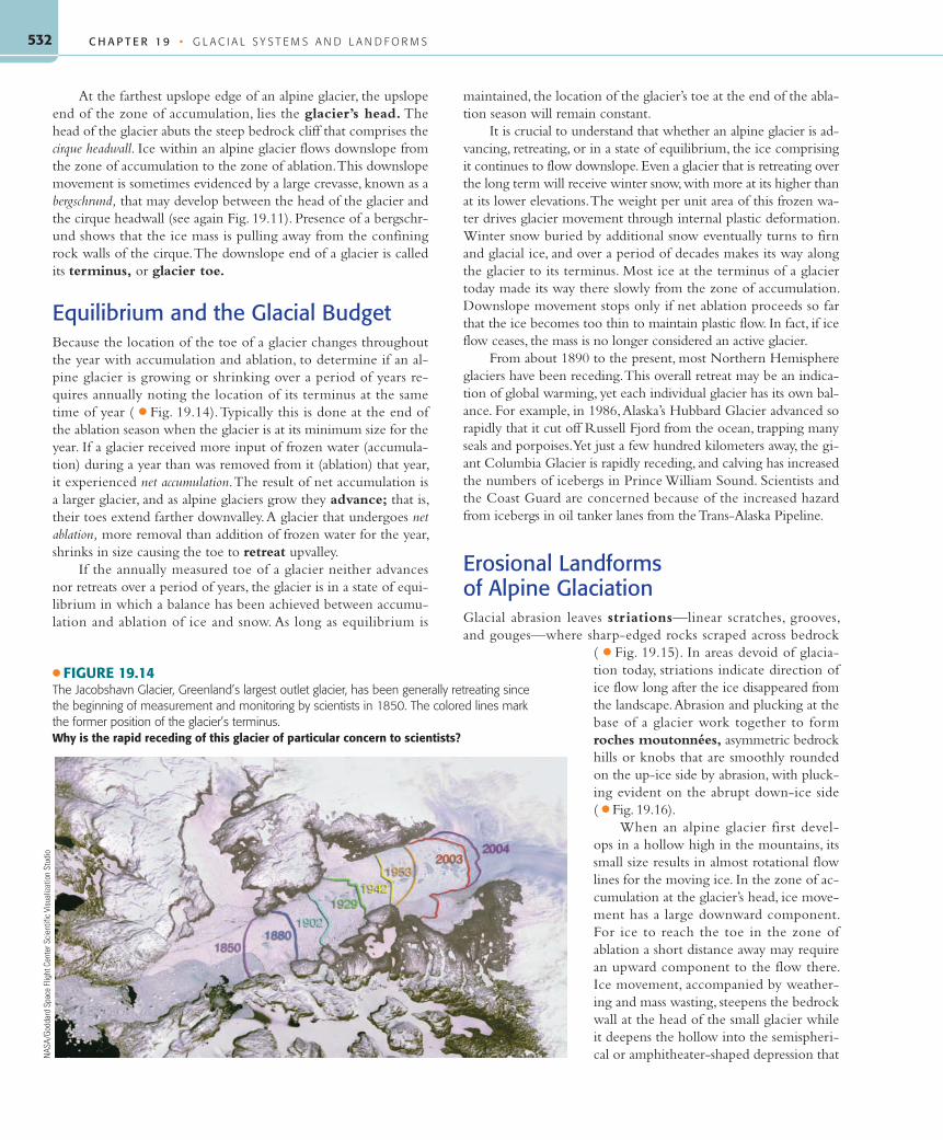
The second category of glacier, continental glaciers, in-cludes glaciers that are much larger and thicker than the alpine types, and that exist where the appropriate conditions for ice for-mation occur because of high latitude ( ● Fig. 19.6). At one time, continental glaciers covered as much as 30% of Earth’s land area. Continental glaciers are subdivided by size into ice sheets and ice caps, with ice sheets exceeding 50,000 square kilometers (19,000 sq mi) in extent. Earth’s two polar ice sheets, the largest type of glacier, still blanket Greenland and Antarctica in the high
55061_19_Ch19_p522_555 pp2.indd 52655061_19_Ch19_p522_555 pp2.indd 526 6/6/08 1:53:36 PM6/6/08 1:53:36 PM
527
● FIGURE 19.4Separate valley glaciers join together to form the larger Susitna Glacier in Alaska. Mount Hayes, the highest mountain in the Alaska Range, is the peak in the background.How are valley glaciers similar to rivers?
USGS
/Aus
tin P
ost
● FIGURE 19.5This cirque glacier in Alaska occupies a classic bowl-shaped basin, the cirque.Why is only part of the ice a bright white color?
USGS
/Aus
tin P
ost
T Y P E S O F G L A C I E R S
● FIGURE 19.6With areas exceeding 50,000 square kilometers (19,000 sq mi), ice sheets are the largest type of continental glacier. Here, a terrain model of Antarctica shows the domelike form of its ice sheet. Ice flows away from the center of the continent, near the South Pole, because the ice there is thickest and the resulting pressure is greatest. This pattern of continental ice flow, from a thicker center to the thinner outer edges, is described as being radial.How is radial ice flow both similar to and different from the radial drainage pattern observed for some stream systems?
NAS
A/Go
ddar
d Sp
ace
Flig
ht C
ente
r Sci
entif
ic V
isua
lizat
ion
Stud
io
55061_19_Ch19_p522_555 pp2.indd 52755061_19_Ch19_p522_555 pp2.indd 527 6/6/08 1:53:37 PM6/6/08 1:53:37 PM

C H A P T E R 1 9 • G L A C I A L S Y S T E M S A N D L A N D F O R M S528
latitudes to a depth of at least 3 kilometers (2 mi). Somewhat smaller, but still large, ice caps are present on some Arctic islands and on Iceland. In contrast to alpine glaciers, ice sheets and ice caps are not confined by the underlying topography, but more or less drown the underlying topography in ice. Direction of flow within ice sheets and ice caps is from thicker to thinner ice, which is radially outward in all directions from a central source area of maximum ice thickness.
How Do Glaciers Flow?Like the slow forms of mass wasting, we normally cannot view glacier movement directly. Nevertheless, flowing ice has a tremen-dous geomorphic impact on the landscape. Most glaciers move through a combination of processes, but internal plastic deformation is the dominant process; virtually all moving glaciers experience this type of flow. Glaciers move in this way when the weight of overlying ice, firn, and snow causes ice crystals at depth to arrange themselves in parallel layers that glide over each other, much like spreading a deck of cards ( ● Fig. 19.7). This internal plastic de-formation happens when a threshold pressure (weight per unit area) from the overlying mass is exceeded. The threshold pressure is achieved at an ice thickness of about 30 meters (100 ft), and the zone experiencing plastic flow extends within (is internal to) the ice mass from that depth to the base of the glacier. The speed with
which the ice flows increases as pressure from overlying material increases and with steeper slopes. Pressure is greater under thicker accumulations of ice and on the upflow side of obstacles at the base of a glacier. Internal plastic deformation causes continental glaciers to flow radially outward from central areas of thicker ice (higher pressure) to marginal areas of thinner ice (lower pressure).
In addition to internal ice movement through plastic defor-mation, many glaciers move by processes concentrated at the base of the ice mass. Many temperate glaciers—those with temperatures at and near the melting point—move by the process of basal sliding (see again Fig. 19.7). In this case, meltwater at the base of the glacier reduces friction between the ice and ground through lubrication and hydrostatic pressure. As a result, when a location at the glacier base has insufficient frictional resistance to oppose the downslope pull of gravity on the ice mass, the affected part of the glacier jerks forward. Steep slopes contribute to the tendency toward basal slid-ing. This type of motion is most important in midlatitude glaciers on steep slopes, particularly during summer when much of the glacier is near the melting point and meltwater is available. Little if any basal sliding occurs during winter and in the colder, polar gla-ciers with little available meltwater. Another type of basal ice flow involves local melting at the base of the glacier, downslope flow of the meltwater, then its refreezing onto the glacier base.
The upper surface of a glacier consists of brittle ice that does not experience plastic deformation. It moves instead by being car-ried along as ice flows in the underlying zone of plastic flow. As
it moves, the ice in the brittle zone fractures and cracks. These ice cracks, called crevasses, are com-mon wherever a glacier becomes stretched, expe-riencing tensional stress, particularly where it flows over a break in slope ( ● Fig. 19.8). Where a glacier locally flows over a steep descent, such as over a sub-glacial cliff, an icefall develops in the brittle upper ice ( ● Fig. 19.9). Here, intersecting crevasses break the ice into a morass of unstable ice blocks that ride on rapid flowing ice below. Ice falls and crevasses are extremely dangerous areas for mountain climb-ers and scientists who venture onto the ice.
Glacial flow rates vary from imperceptible fractions of a centimeter per day to as much as 30 meters (100 ft) per day. Glaciers flow more rapidly where the slopes are steep, where the ice is thick-est, and where temperatures are warmest. For ex-ample, the Nisqually Glacier, on the steep slopes of Washington’s Mount Rainier, flows 38 centimeters (16 in.) per day in summer. As a general rule, tem-perate alpine glaciers flow much faster than the cold polar continental glaciers.
The flow of an individual glacier var ies from time to time with changes in the dynamic equilibrium and from place to place because of variations in the gradient over which it flows or differences in the friction encountered with adjacent rock. Within an alpine glacier, the rate of movement is greatest on the glacier surface to-ward the middle of the ice because this location experiences accumulated movement from layers
● FIGURE 19.7Most glacier movement is by internal plastic deformation—flow as a plastic solid—resulting from the weight of the overlying ice, firn, and snow. Glaciers with meltwater at their base also move by basal slippage when the resulting reduction in friction allows the ice to slip over the ground. The entire vertical column of the glacier moves the same amount, B-B', due to basal sliding. Although pressure is greater lower in the ice, plastic flow is cumulative upward so that flow deeper in the ice column carries along overlying ice layers. As a result, ice flow velocity is greatest at the glacier’s surface, A-A'.Does the ice on the top of the glacier flow or just ride along on the ice below?
Total surfacemovement
Plasticflow
A '
A
Basalsliding
Bedrock
Flowdirection
Ice
Zone of brittle ice
Zone of plastic flow
B
B '
55061_19_Ch19_p522_555 pp2.indd 52855061_19_Ch19_p522_555 pp2.indd 528 6/6/08 1:53:42 PM6/6/08 1:53:42 PM

529
of plastic flow below and is farthest from frictional resistance with the valley sides.
Sometimes a glacier’s velocity will increase by many times its normal rate, causing the glacier to advance hundreds of meters per year. The reasons for such enormous glacial surges are not com-pletely clear, although lubrication of a glacier’s bed by pockets of meltwater explains some of them.
Glaciers as Geomorphic AgentsBecause a deep, and therefore heavy, accumulation of ice is re-quired for glaciers to flow, even the smaller alpine glaciers are particularly powerful geomorphic agents able to perform great amounts of geomorphic work. Whether it is an alpine glacier carving out a trough-shaped valley or a continental glacier goug-ing out the basins of the North American Great Lakes, the work done by glaciers is impressive.
Glaciers remove and entrain rock particles by two erosional processes. Glacial plucking is the process by which moving ice freezes onto loosened rocks and sediments, incorporating them into the flow. Weathering, particularly the freezing of water in bedrock joints and fractures, breaks rock fragments loose, encour-aging plucking. Once load is entrained at the base and sides of the ice, moving glaciers are armed with clastic particles that are very effective tools for scraping and gouging out more rock material by the erosional process of abrasion ( ● Fig. 19.10). Bedrock obstructions subjected to intense glacial abrasion are typically smoother and more rounded than those produced by plucking.
● FIGURE 19.8A large crevasse on the Yanert glacier in Denali National Park, Alaska.Why does the surface of a glacier break into crevasses?
M. T
rapa
sso
● FIGURE 19.9Icefalls are the glacial equivalent of rapids or waterfalls in a river and are riddled with crevasses that break the ice into huge, unstable blocks. Although glacial ice flows much more slowly than running water, icefalls are the most rapidly moving and changing part of a glacier. They are one of the most treacherous parts of a glacier to cross because the huge ice blocks can shift at any time.
© M
att E
bine
r
G L A C I E R S A S G E O M O R P H I C A G E N T S
● FIGURE 19.10The sediment load transported by glaciers is a poorly sorted mix of grain sizes. As soon as a glacier obtains some load, those clastic particles are used as tools to help erode more rock by abrasion. Here, a cobble from a glacial deposit shows scrapes and scratches obtained by grinding against bedrock and other particles as it was carried in the ice.How does sediment load of a glacier differ from sediment load of a stream?
D.Sa
ck
55061_19_Ch19_p522_555 pp2.indd 52955061_19_Ch19_p522_555 pp2.indd 529 6/6/08 1:53:43 PM6/6/08 1:53:43 PM

C H A P T E R 1 9 • G L A C I A L S Y S T E M S A N D L A N D F O R M S530
Unlike the situation with liquid water in streams, volume and velocity of flow do not directly determine the particle sizes that plastic-flowing solid ice can erode and transport. Plucking and abrasion provide the bottom and sides of glaciers with a cha-otic load of rock fragments of all sizes, from clay-sized crushed rock, called rock flour, to giant boulders. Mass wasting along steep mountain slopes, especially above alpine glaciers, contributes sedi-ment, also of a variety of grain sizes, to the ice surface and sides. Also in contrast to streams, little sorting of sediment by size is ac-complished by glaciers during transportation and deposition. This lack of sorting by size makes glacial deposits look very different from accumulations of stream deposits. Because of this contrast in
the two types of sediment, it is logical that they are referred to by two different terms. Whereas stream-deposited sediment is called alluvium, sediment deposited directly by moving ice is till.
Alpine GlaciersFrom a mass balance perspective, alpine glaciers consist of two func-tional parts, or zones ( ● Fig. 19.11). The colder, snowier upslope portion of a glacier, where annual accumulation (input) exceeds annual ablation (output), is the zone of accumulation. In con-trast, in the warmer downslope portion of an alpine glacier, the
● FIGURE 19.11Environmental Systems: The Hydrologic System—Glaciers. Glacial systems are controlled by the input of frozen water (accumulation), primarily from winter snowfall, and the loss of frozen water (ablation), primarily from summer melting. In the higher-elevation, colder part of the glacier, called the zone of accumulation, annual input exceeds annual loss. In the lower-elevation, warmer zone of ablation, annual ice loss exceeds addition of frozen water. The equilibrium line marks the elevation where annual accumulation equals annual ablation. Over the years snowfall on the zone of accumulation, buried by successive snow layers, changes into denser firn and later into even denser glacial ice. When the ice reaches a threshold depth, the deeply buried ice deforms plastically in response to the overlying weight and flows downslope. The ice flows faster (1) as the overlying weight increases due to greater input, and (2) as the ice flows over steeper slopes. This continuous, internal plastic flow transports ice from the zone of accumulation toward the toe of the glacier in the zone of ablation. If the glacier as a whole experiences more accumulation than ablation in a year, the increase in mass will cause some thickening of the ice, but it will also cause the toe of the glacier to advance farther downvalley. If ablation exceeds accumulation for the year, the glacier will lose mass and retreat. Equilibrium exists if annual accumulation equals annual ablation. At present, most of the world’s glaciers are receding, some quite rapidly. Scientists are concerned about the potential effects of global warming on glacial systems, especially on the continental ice sheets of Antarctica and Greenland. Increasing world temperatures can shift glacial systems toward a new equilibrium, at a smaller size and mass, with more rapid ice loss through melting, calving into water bodies, and other means. A significant decrease in the amount of glacial ice on Earth will result in a global rise in sea level that would affect low-lying coastal areas.
noffalvingss
55061_19_Ch19_p522_555 pp2.indd 53055061_19_Ch19_p522_555 pp2.indd 530 6/6/08 1:53:48 PM6/6/08 1:53:48 PM

531
zone of ablation, annual ablation exceeds annual accumulation. Winter is the dominant accumulation season and summer is the dominant ablation season. Alpine glaciers change size, sometimes quite dramatically, over the course of a year. The toe of a glacier lies farthest downvalley near the end of winter and farthest upvalley at the end of the ablation season near the end of summer.
The equilibrium line marks the boundary between the zones of accumulation and ablation on an alpine glacier. It in-dicates where annual accumulation equals annual ablation for the glacier ( ● Fig. 19.12). The equilibrium line differs from the snow line, which is the elevation where snow cover begins on a landscape. The snow line regularly changes position through the seasons and in response to the weather, including after every snowfall. The equilibrium line, in contrast, represents the eleva-tion at which the ground is covered by snow all year long.
Several factors influence the location of the equilibrium line. The interaction between latitude and elevation, both of which affect temperature, is an important factor. On mountains near the equator, the equilibrium line lies at very high eleva-tions. Elevation of the equilibrium line decreases with increas-ing latitude until it coincides with sea level in the polar regions. Equally important to temperature in determining the position of the equilibrium line is the amount of snowfall received dur-ing winter. With colder temperatures and greater snowfall, the equilibrium line will decrease in elevation; it retreats to higher elevations if the climate warms. Other attributes causing varia-tions in the equilibrium-line elevation include the amount of insolation. A shady mountain slope will have a lower equilib-rium line than one that receives more insolation. Wind is an-other factor because it produces snowdrifts on the leeward side of mountain ranges. In the middle latitudes of the Northern Hemisphere, the equilibrium line is lower on the north (shaded) and east (leeward) slopes of mountains. Consequently, the most significant glacier development in this region is on north-facing and east-facing slopes ( ● Fig. 19.13).
USGS
/Aus
tin P
ost
A L P I N E G L A C I E R S
● FIGURE 19.13This topographic map of part of Rocky Mountain National Park in Colo-rado illustrates the impact of slope aspect (compass direction) on gla-ciation. In the Northern Hemisphere at middle to high latitudes, slopes facing north or northeast tend to be shaded from the sun, allowing greater amounts of snow and ice to accumulate there. This encourages glaciation on north- and east-facing slopes.
USGS
● FIGURE 19.12A valley glacier on Alaska’s Kenai Peninsula displays a blue zone under-going ablation at lower elevations contrasted with a white accumulation zone at the glacier’s higher elevations. The visible contact between the two zones on the photograph, however, is not necessarily the equilib-rium line because it may not represent the elevation at which accumula-tion equaled ablation for the year.What additional information would be needed to assess if the boundary between the white and blue zones on this photo is the glacier’s annual equilibrium line?
55061_19_Ch19_p522_555 pp2.indd 53155061_19_Ch19_p522_555 pp2.indd 531 6/6/08 1:53:56 PM6/6/08 1:53:56 PM
C H A P T E R 1 9 • G L A C I A L S Y S T E M S A N D L A N D F O R M S532
At the farthest upslope edge of an alpine glacier, the upslope end of the zone of accumulation, lies the glacier’s head. The head of the glacier abuts the steep bedrock cliff that comprises the cirque headwall. Ice within an alpine glacier flows downslope from the zone of accumulation to the zone of ablation. This downslope movement is sometimes evidenced by a large crevasse, known as a bergschrund, that may develop between the head of the glacier and the cirque headwall (see again Fig. 19.11). Presence of a bergschr-und shows that the ice mass is pulling away from the confining rock walls of the cirque. The downslope end of a glacier is called its terminus, or glacier toe.
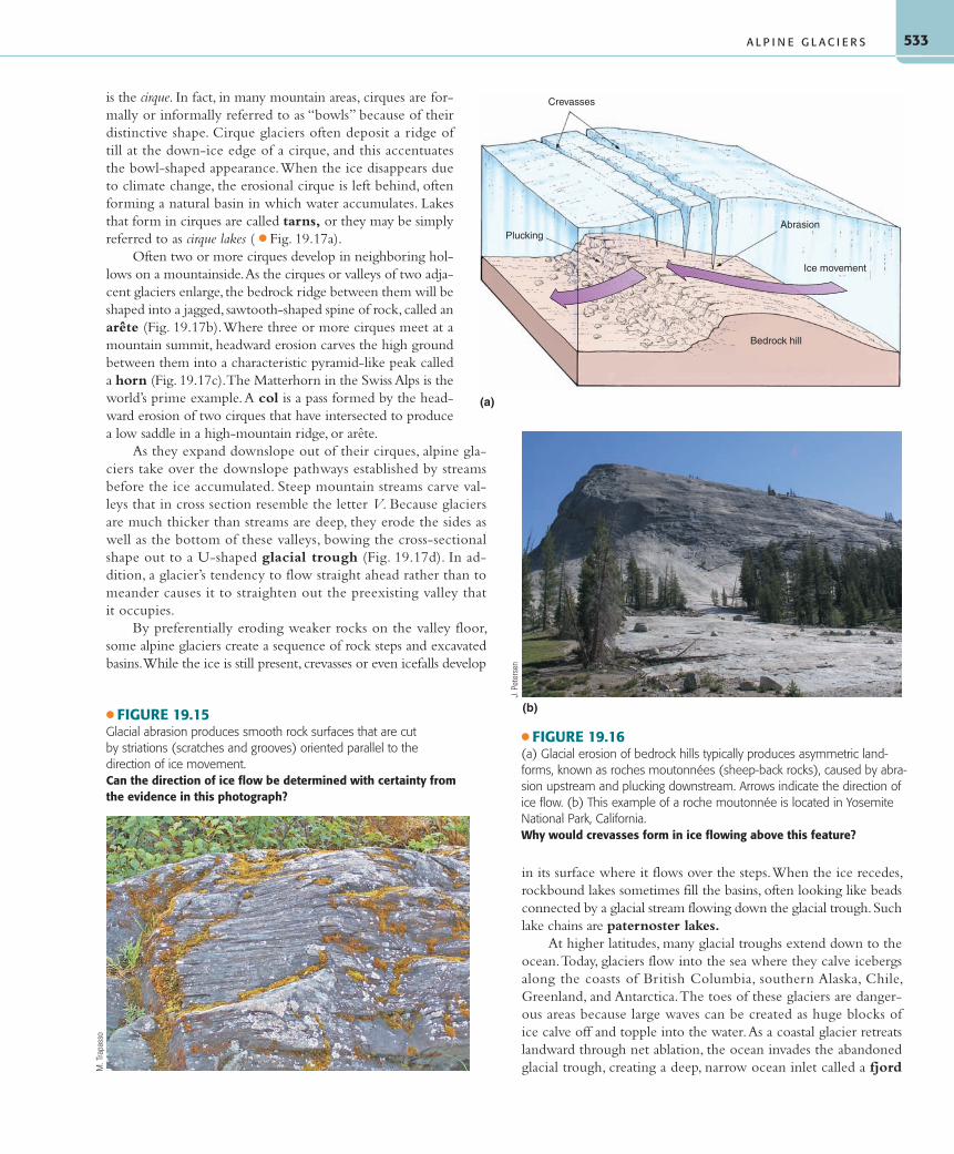
Equilibrium and the Glacial BudgetBecause the location of the toe of a glacier changes throughout the year with accumulation and ablation, to determine if an al-pine glacier is growing or shrinking over a period of years re-quires annually noting the location of its terminus at the same time of year ( ● Fig. 19.14). Typically this is done at the end of the ablation season when the glacier is at its minimum size for the year. If a glacier received more input of frozen water (accumula-tion) during a year than was removed from it (ablation) that year, it experienced net accumulation. The result of net accumulation is a larger glacier, and as alpine glaciers grow they advance; that is, their toes extend farther downvalley. A glacier that undergoes net ablation, more removal than addition of frozen water for the year, shrinks in size causing the toe to retreat upvalley.
If the annually measured toe of a glacier neither advances nor retreats over a period of years, the glacier is in a state of equi-librium in which a balance has been achieved between accumu-lation and ablation of ice and snow. As long as equilibrium is
maintained, the location of the glacier’s toe at the end of the abla-tion season will remain constant.
It is crucial to understand that whether an alpine glacier is ad-vancing, retreating, or in a state of equilibrium, the ice comprising it continues to flow downslope. Even a glacier that is retreating over the long term will receive winter snow, with more at its higher than at its lower elevations. The weight per unit area of this frozen wa-ter drives glacier movement through internal plastic deformation. Winter snow buried by additional snow eventually turns to firn and glacial ice, and over a period of decades makes its way along the glacier to its terminus. Most ice at the terminus of a glacier today made its way there slowly from the zone of accumulation. Downslope movement stops only if net ablation proceeds so far that the ice becomes too thin to maintain plastic flow. In fact, if ice flow ceases, the mass is no longer considered an active glacier.
From about 1890 to the present, most Northern Hemisphere glaciers have been receding. This overall retreat may be an indica-tion of global warming, yet each individual glacier has its own bal-ance. For example, in 1986, Alaska’s Hubbard Glacier advanced so rapidly that it cut off Russell Fjord from the ocean, trapping many seals and porpoises. Yet just a few hundred kilometers away, the gi-ant Columbia Glacier is rapidly receding, and calving has increased the numbers of icebergs in Prince William Sound. Scientists and the Coast Guard are concerned because of the increased hazard from icebergs in oil tanker lanes from the Trans-Alaska Pipeline.
Erosional Landforms of Alpine GlaciationGlacial abrasion leaves striations—linear scratches, grooves, and gouges—where sharp-edged rocks scraped across bedrock
( ● Fig. 19.15). In areas devoid of glacia-tion today, striations indicate direction of ice flow long after the ice disappeared from the landscape. Abrasion and plucking at the base of a glacier work together to form roches moutonnées, asymmetric bedrock hills or knobs that are smoothly rounded on the up-ice side by abrasion, with pluck-ing evident on the abrupt down-ice side ( ● Fig. 19.16).
When an alpine glacier first devel-ops in a hollow high in the mountains, its small size results in almost rotational flow lines for the moving ice. In the zone of ac-cumulation at the glacier’s head, ice move-ment has a large downward component. For ice to reach the toe in the zone of ablation a short distance away may require an upward component to the flow there. Ice movement, accompanied by weather-ing and mass wasting, steepens the bedrock wall at the head of the small glacier while it deepens the hollow into the semispheri-cal or amphitheater-shaped depression that
● FIGURE 19.14The Jacobshavn Glacier, Greenland’s largest outlet glacier, has been generally retreating since the beginning of measurement and monitoring by scientists in 1850. The colored lines mark the former position of the glacier’s terminus.Why is the rapid receding of this glacier of particular concern to scientists?
NAS
A/Go
ddar
d Sp
ace
Flig
ht C
ente
r Sci
entif
ic V
isua
lizat
ion
Stud
io
55061_19_Ch19_p522_555 pp2.indd 53255061_19_Ch19_p522_555 pp2.indd 532 6/6/08 1:53:57 PM6/6/08 1:53:57 PM
533
is the cirque. In fact, in many mountain areas, cirques are for-mally or informally referred to as “bowls” because of their distinctive shape. Cirque glaciers often deposit a ridge of till at the down-ice edge of a cirque, and this accentuates the bowl-shaped appearance. When the ice disappears due to climate change, the erosional cirque is left behind, often forming a natural basin in which water accumulates. Lakes that form in cirques are called tarns, or they may be simply referred to as cirque lakes ( ● Fig. 19.17a).
Often two or more cirques develop in neighboring hol-lows on a mountainside. As the cirques or valleys of two adja-cent glaciers enlarge, the bedrock ridge between them will be shaped into a jagged, sawtooth-shaped spine of rock, called an arête (Fig. 19.17b). Where three or more cirques meet at a mountain summit, headward erosion carves the high ground between them into a characteristic pyramid-like peak called a horn (Fig. 19.17c). The Matterhorn in the Swiss Alps is the world’s prime example. A col is a pass formed by the head-ward erosion of two cirques that have intersected to produce a low saddle in a high-mountain ridge, or arête.
As they expand downslope out of their cirques, alpine gla-ciers take over the downslope pathways established by streams before the ice accumulated. Steep mountain streams carve val-leys that in cross section resemble the letter V. Because glaciers are much thicker than streams are deep, they erode the sides as well as the bottom of these valleys, bowing the cross-sectional shape out to a U-shaped glacial trough (Fig. 19.17d). In ad-dition, a glacier’s tendency to flow straight ahead rather than to meander causes it to straighten out the preexisting valley that it occupies.
By preferentially eroding weaker rocks on the valley floor, some alpine glaciers create a sequence of rock steps and excavated basins. While the ice is still present, crevasses or even icefalls develop
in its surface where it flows over the steps. When the ice recedes, rockbound lakes sometimes fill the basins, often looking like beads connected by a glacial stream flowing down the glacial trough. Such lake chains are paternoster lakes.
At higher latitudes, many glacial troughs extend down to the ocean. Today, glaciers flow into the sea where they calve icebergs along the coasts of British Columbia, southern Alaska, Chile, Greenland, and Antarctica. The toes of these glaciers are danger-ous areas because large waves can be created as huge blocks of ice calve off and topple into the water. As a coastal glacier retreats landward through net ablation, the ocean invades the abandoned glacial trough, creating a deep, narrow ocean inlet called a fjord
● FIGURE 19.15Glacial abrasion produces smooth rock surfaces that are cut by striations (scratches and grooves) oriented parallel to the direction of ice movement.Can the direction of ice flow be determined with certainty from the evidence in this photograph?
M. T
rapa
sso
Crevasses
PluckingAbrasion
Ice movement
Bedrock hill
(a)
● FIGURE 19.16(a) Glacial erosion of bedrock hills typically produces asymmetric land-forms, known as roches moutonnées (sheep-back rocks), caused by abra-sion upstream and plucking downstream. Arrows indicate the direction of ice flow. (b) This example of a roche moutonnée is located in Yosemite National Park, California.Why would crevasses form in ice flowing above this feature?
(b)
J. P
eter
sen
A L P I N E G L A C I E R S
55061_19_Ch19_p522_555 pp2.indd 53355061_19_Ch19_p522_555 pp2.indd 533 6/6/08 1:54:00 PM6/6/08 1:54:00 PM

C H A P T E R 1 9 • G L A C I A L S Y S T E M S A N D L A N D F O R M S534
( ● Fig. 19.18). The fjords of Scotland, Norway, Iceland, and New Zealand show that glaciers in those regions reached the sea during the Pleistocene. Most of the deep, narrow channels of Washington’s Puget Sound were carved into bedrock by glacial erosion and later invaded by the sea. Unlike streams, which erode only to base level, glaciers can erode somewhat below sea level, but most fjords were carved during times of extensive Pleistocene glaciation when sea level was lower than it is today, and they were later submerged as sea level rose with melting of the glaciers.
Most large valley glaciers have tributary glaciers. These tribu-tary glaciers, like the main ice stream, also carve U-shaped chan-nels (see again Fig. 19.3). However, because these tributaries have less ice volume than the main glacier, they also have lower rates of erosion and less ability to erode their channels. As a result, their troughs are smaller and not as deep as those of the main glacier. Nevertheless, during peak glacial phases, the ice surface of smaller tributary glaciers flows in at the surface level of the larger gla-cier. Not until the glaciers begin to wane does the difference in
(a) (b)
(c) (d)
● FIGURE 19.17Alpine glaciation produced each of these erosional landforms. (a) This glacially carved cirque in the Sierra Nevada contains a tarn (lake in a cirque). (b) Jagged, narrow ridges of rock, such as this one in the Sierra Nevada, are known as arêtes. (c) The Matterhorn in the Swiss Alps is a classic example of a horn. Horns are formed when several glaciers cut headward into a mountain peak. (d) Glaciers carve steep-sided U-shaped val-leys called glacial troughs. Little Cottonwood Canyon, east of Salt Lake City in the Wasatch Range of the Rocky Mountains, is an excellent example of a glacial trough.Can you identify on the photo in (d) the height to which ice filled the valley?
J. P
eter
sen
© B
rand
X P
ictu
res/
Pic
ture
Ques
t
J. P
eter
sen
D. S
ack
55061_19_Ch19_p522_555 pp2.indd 53455061_19_Ch19_p522_555 pp2.indd 534 6/6/08 1:54:05 PM6/6/08 1:54:05 PM
535
height between their trough floors become apparent. Once the troughs are no longer occupied by glaciers, the tributary troughs form hanging valleys ( ● Fig. 19.19). A stream that flows down such a channel will drop down to the lower glacial valley by a high waterfall or a series of steep rapids. Yosemite Falls and Brid-alveil Falls in Yosemite National Park are excellent examples of waterfalls cascading out of hanging valleys. Yosemite Valley itself is a beautiful example of a glacial trough. A possible scenario in the development of alpine glacial erosional topography is illustrated in ● Figure 19.20.
Landscapes eroded by alpine glaciers show a sharp contrast between the deep, U-shaped glacial troughs scoured smooth by ice flow and the jagged peaks above the former ice levels. The rugged quality of these upper surfaces is caused primarily by mechanical weathering above the ice surface and by glacial un-dercutting to create horns and arêtes ( ● Fig. 19.21). In North America, spectacular rugged alpine glacial terrains are found in the mountains of Alaska, in California’s Sierra Nevada, and in the Rockies (see Map Interpretation: Alpine Glaciation).
Depositional Landforms of Alpine GlaciationLike glacial load, glacial deposits include clastic sediments of a wide range of sizes, frequently mixed with layers of pollen, other plant matter, and soil. In addition to the poorly sorted till deposited directly by glacial ice, meltwater streams, lakes, and wind occurring in association with glaciers contribute to the deposition of sediments and creation of landforms in gla-cial terrain. Glaciofluvial is used to specify the better sorted and stratified fluvial deposits related to glacial meltwater. All deposits of glacial ice or its meltwater, and therefore including till and glaciofluvial deposits, are included within the general term drift ( ● Fig. 19.22).
Active alpine glaciers deposit load primarily along the sides and toe of the ice. Landforms constructed from glacial deposits, typically ridges of till along these margins of glaciers, are mo-raines. Till deposited as ridges paralleling the side margins of a glacier are lateral moraines ( ● Fig. 19.23a). Where two trib-utary valley glaciers join together, their lateral moraines merge downflow creating a medial moraine in the center of the trunk glacier. Medial moraines cause the characteristic dark stripes seen on the surface of many alpine glaciers (Fig. 19.23b). At the toe of a glacier, sediment carried forward by the “conveyor belt” of ice or pushed ahead of the glacier is deposited in a jumbled heap of material of all grain sizes, forming a curved depositional ridge called an end moraine (Fig. 19.23c). End moraines that mark the farthest advance of a glacier are terminal moraines. End moraines deposited as a consequence of a temporary pause by a retreating glacier, followed by a stabilization of the ice front prior to further recession, are called recessional moraines. A retreat-ing glacier also deposits a great deal of till on the floor of the gla-cial trough as the ice melts away and leaves its load behind. The hummocky landscape created by these glacial deposits is called ground moraine.
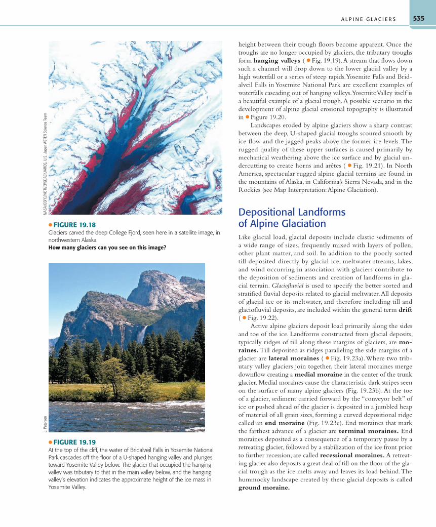
● FIGURE 19.18Glaciers carved the deep College Fjord, seen here in a satellite image, in northwestern Alaska.How many glaciers can you see on this image?
NAS
A/GS
FC/M
ETI/E
RSDA
C/JA
ROS,
U.S
. Jap
an A
STER
Sci
ence
Team
● FIGURE 19.19At the top of the cliff, the water of Bridalveil Falls in Yosemite National Park cascades off the floor of a U-shaped hanging valley and plunges toward Yosemite Valley below. The glacier that occupied the hanging valley was tributary to that in the main valley below, and the hanging valley’s elevation indicates the approximate height of the ice mass in Yosemite Valley.
J. P
eter
sen
A L P I N E G L A C I E R S
55061_19_Ch19_p522_555 pp2.indd 53555061_19_Ch19_p522_555 pp2.indd 535 6/6/08 1:54:11 PM6/6/08 1:54:11 PM

C H A P T E R 1 9 • G L A C I A L S Y S T E M S A N D L A N D F O R M S536
(a) Preglacial fluvial topography(b) Maximum glaciation
Tarn
Horn Hangingvalley
Ci
GlacialtroughArête
Braided meltwater streams laden with sediment commonly issue from the glacier terminus ( ● Fig. 19.24). The sediment, called glacial outwash, is deposited beyond the terminal mo-raine, with larger rocks deposited first, followed downstream by progressively finer particles. Often resembling an alluvial fan con-fined by valley walls, this depositional form left by braided streams is called a valley train. Valleys in glaciated regions may be filled to depths of a few hundred meters by outwash or by deposits from moraine-dammed lakes.
Continental GlaciersIn terms of their size and shape, continental glaciers, which consist of ice sheets or the somewhat smaller ice caps, are very different from alpine glaciers. However, all glaciers share certain characteristics and processes, and much of what we have discussed about alpine glaciers also applies to continental glaciers. The geomorphic work of the two categories of glaciers differs primarily in scale, attributable to the enormous disparity in size between continental and alpine glaciers.
Ice sheets and ice caps are shaped somewhat like a convex lens in cross section, thicker in the center and thinning toward the edges. They flow radially outward in all directions from where the pressure is greatest, in the thick, central zone of accumulation, to the surrounding zone of ablation ( ● Fig. 19.25). Like all gla-ciers, ice sheets and ice caps advance and retreat by responding to changes in temperature and snowfall. As with alpine glaciers flowing down preexisting stream valleys, movement of advanc-ing continental glaciers takes advantage of paths of least resistance found in preexisting valleys and belts of softer rock.
Existing Continental GlaciersGlaciers of all categories currently cover about 10% of Earth’s land area. In area and ice mass, alpine glaciers are almost insignifi-cant compared to the huge ice sheets of Greenland and Antarctica,
● FIGURE 19.20(a) Preexisting mountain stream valleys provide the path of least resis-tance toward lower elevations, and (b) are therefore preferred locations for advancing alpine glaciers. (c) After the ice disappears, the tremen-dous geomorphic work accomplished by the alpine glaciers is evident in the distinctive erosional landforms created by the moving ice.How do the valley profiles change from preglacial to postglacial times?
55061_19_Ch19_p522_555 pp2.indd 53655061_19_Ch19_p522_555 pp2.indd 536 6/6/08 1:54:13 PM6/6/08 1:54:13 PM