Name: Period: World Geography Fall 2011 WORLD...
17
Name: _____________________________________________________________ Period: _________ World Geography Fall 2011 WORLD GEOGRAPHY FALL FINAL EXAM REVIEW Use your notes, textbook, tutorial times and project share course website to help you study for the final exam.. UNIT 1: PHYSICAL PROCESSES AND HUMAN PROCESSES For each item in the text box, categorize the item to the correct geographic process. War Deserts Natural Disasters Migration Trade Wind Systems Mountains Innovation Ocean Currents Globalization Human Process Physical Process HUMAN CHARACTERISTICS PHYSICAL CHARACTERISTICS Use the map below to help you understand the concept of Spatial Diffusion. SPATIAL DIFFUSION IS: Explain how the map shows Spatial Diffusion. What landform has helped spatial diffusion? Was the landform that caused the human migration an aid (help diffusion) or a barrier (stop diffusion)? List at least three examples for both sides of the T chart.
Transcript of Name: Period: World Geography Fall 2011 WORLD...

Name: _____________________________________________________________ Period: _________ World Geography Fall 2011
WORLD GEOGRAPHY FALL FINAL EXAM REVIEW Use your notes, textbook, tutorial times and project share course website to help you study for the final exam..
UNIT 1: PHYSICAL PROCESSES AND HUMAN PROCESSES
For each item in the text box, categorize the item to the correct geographic process.
War Deserts
Natural Disasters Migration
Trade Wind Systems
Mountains Innovation
Ocean Currents Globalization
Human Process
Physical Process
HUMAN CHARACTERISTICS
PHYSICAL CHARACTERISTICS
Use the map below to help you understand the concept of Spatial Diffusion.
SPATIAL DIFFUSION IS: Explain how the map shows Spatial Diffusion. What landform has helped spatial diffusion?
Was the landform that caused the human migration an aid (help diffusion) or a barrier (stop diffusion)? List at least three examples for both sides of
the T chart.

Use the map below to help you understand important geographic trends.
Label the following lines: Equator Prime Meridian Tropic of Cancer Tropic of Capricorn
Which line separates the Northern and Southern Hemisphere? Which line separates the Western and Eastern Hemisphere? Which type of lines is coherent with type of climate found on the Earth? (Think about where it is tropical and hot on the Earth vs. polar and cold) What is the trend of the climate as you move away from the line in the previous answer? LOCATION: RELATIVE LOCATION IS THE ___________________________ OF A PLACE ___________________ TO ANOTHER PLACE. ABSOLUTE LOCATION IS _______________________________________________________ AND USES ________________ & ______________________________ COORDINATES TO SHOW THE PLACE’S __________________ LOCATION. HUMAN ENVIRONMENT INTERACTION: Circle if the statement represents how humans DEPEND, ADAPT, OR MODIFY the environment. “Many Japanese farmers use terrace farming along mountain slopes to naturally water their crops.” DEPEND ADAPT MODIFY “A farmer rotates his crops on his land to allow the land to rebuild its soil. Rotation of crops brings more food for farmers to sell.” DEPEND ADAPT MODIFY “With the Texas drought this summer, many government policies have banned people from having BBQ and using fireworks.” DEPEND ADAPT MODIFY

FORMAL REGIONS:
UNCTIONAL REGIONS:
ERCEPTUAL/VERNACULAR REGIONS:
F P
TRUE OR FALSE: For each statement, decide if it is TRUE o FALSE. If the statement is false, write a correct statement to
RUE / FALSE Human activity can only affect the Earth in positive way.
RUE/ FALSE The Columbian Exchange (trading between the Atlantic Ocean between the Old World and the New World) is
RUE/ FALSE Facebook and other social networks is not considered an example of spatial diffusion.
EGION: Determine which type of region the following regions are:
The South” in the US ________________________ Region
ell Phone Coverage _________________________ Region
tates and City Limits ________________________ Region
Aggie land” ________________________________ Region
The Bible Belt” _____________________________ Region
UNIT 2: PHYSICAL GEOGRAPHY
Label the parts of the Earth: (p 28)
rchange the false statement into a true statement.
T T
considered a human process.
T R
“ C S “ “
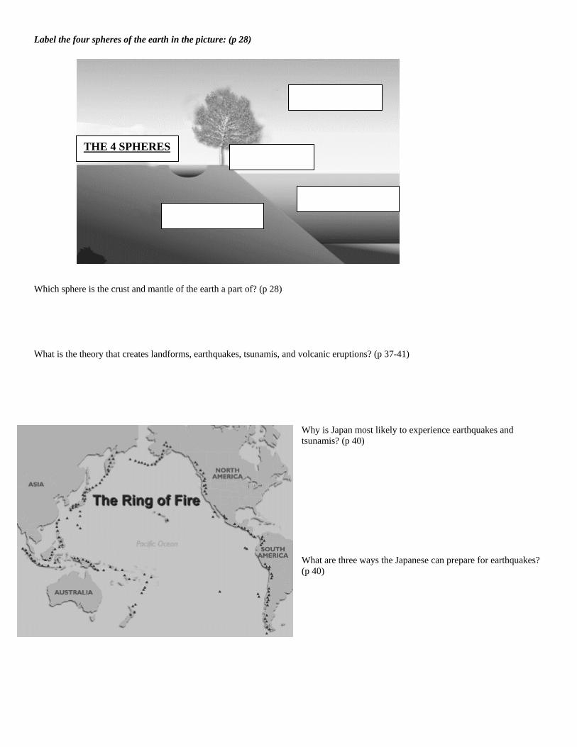
Label the four spheres of the earth in the picture: (p 28)
hich sphere is the crust and mantle of the earth a part of? (p 28)
What is the theory that creates landforms, earthquakes, tsunamis, and volcanic eruptions? (p 37-41)
h
THE 4 SPHERES
W
Why is Japan most likely to experience earthquakes and
at are three ways the Japanese can prepare for earthquakes?
tsunamis? (p 40) W(p 40)

According to the map, what type of physical feature are most of the urban areas located near?
What are the four major factors that affect climate? (p 54)
What line of latitude are most of the world’s tropical vegetation located? (p 60-61)
the climograph comparing?
conclusion can be made about this location’s climate?
What is What(Hint: write a statement comparing the yearly trend of the temperature and precipitation)

A synonym is a word that is similar to a vocabulary word. List three synonyms of the word BARRIER:
hat are three examples of physical geographic features that are considered barriers to migration in Latin America?
List ree synonyms of the word AID:
Wh e three examples of physical geographic features that are considered aids to migration in Latin America?
ch monsoon season brings a drought situation to the Indian
h monsoon season is beneficial for farmers? (p 557)
W th
at ar
Whisubcontinent? (p557) Whic

What is happing to the vegetation in the
hat scale does deforestation impact? (Circle
OCAL SCALE
EGIONAL SCALE
LOBAL SCALE
Amazon Rainforest? (p 210) Wthe Answer) L R G
ook at the Resource Map of Europe on page 276.
it necessary for European nations to trade globally? (HINT: Look at the size of the European nations, do they have all the resources
Whi ypes of areas (either rural or urban) have evidence of acid rain? (p 284-285)
What are some of the effects of acid rain to forests, buildings, your personal belongings, etc.? (pg 284-285)
efine Polder: (p282)
ow do polders change the physical geography of the Netherlands? (p282)
L Isthat they want?)
ch t
D H

Free Enterprise
Socialism
Communism
1.____________
.____________
____________
.____________
.____________
.____________
._____________
2 3 4 5.____________ 6 7 8 9._____________ 10.____________
Country List:
United States
United Kingdom
South Korea
Venezuela
North Korea India
France
Cuba
China
Mexico
Socialism
Communism
UNIT 3: ECONOMIC GEOGRAPHY
Using your notes and knowledge of world geography, fill in the economic systems chart with the correct characteristics. Look on
What to produce? How to produce it? Who consumes the
Does the country’s
page 91 in the textbook for help if needed. Put who controls economic decisions.
product? GDP increase or
decrease?
Free Enterprise (M )
arket/Capitalism
Socialism (Mixed)
Communism
(Command)
ECONOMIC SPECTRUM
Place each country in the correct location along t e economic spectrum. Use your notes from class.
h

Based off of your readings, create a definition for INFRASTRUCTURE
What is the most important type of infrastructure for a country? Explain your answer.
How can infrastructure affect a country’s development? Explain your answer.
INFRASTRUCTURE & DEVELOPMENT
Read about Infrastructure on pag s 94, 177, & 212 in the textbook:
Circle the scale of each type of economic level:
ommercial Agriculture SMALL MODERATE LARGE
ubsistence Agriculture SMALL MODERATE LARGE
ottage Industries SMALL MODERATE LARGE
ommercial Industries SMALL MODERATE LARGE
As a country’s economy develops, which type of scale of production and economic activity would be the most profitable?
e
Based off of your readings, list at least five examples of INFRASTRUCTURE
C S C C

Which country would be considered the MOST
Which demographics helped you develop your
DEVELOPED?
answer? (List at least 3)
Most Developed Least Developed
“University researchers present a new type of fuel
m efficient automobile to reduce the air pollution in ajor urban areas to the head of the Department ofEnvironmental Agencies in Washington D.C.”
“Travel agencies work overtime while helping clients prepare summer time vacations.”
“Maquiladora factories are located near the
HUMAN DEVELOPMENT INDEX
border of Mexico and United States to allow for products to be produced at a cheaper
rate.”
Use the chart and your knowledge of world geogra y to help you study the demographics for the test!
Use the demographics to rank each country from the MOST DEVELOPED to the LEAST DEVELOPED:
How is the standard of living of the more developed countries compare to the standard of living in the least developed
LEVELS OF ECONOMIC ACTIVITIES
ph
countries? Explain your answer.
For each example of economic activity, write which type of level the activity would be considered: primary, secondary, tertiary,
quaternary. See page 92 in the textbook for help.
“Drilling for oil off of the coast of Scotland w ill provide more fossil fuel resources for the
European Union.”
European Union
According to the text on page 327 and Primary Source A on ge 328, what do EU members think the union will do to the
According to the text on page 327 and Primary Source A on page 328, what will the euro currency do to the economies of the
pa
national economies?
European Union members?
NAFTA
According to the text on page 220, what is the purpose of NAFTA?
ow is NAFTA supposed to help the countries of Canada, United States and Mexico?
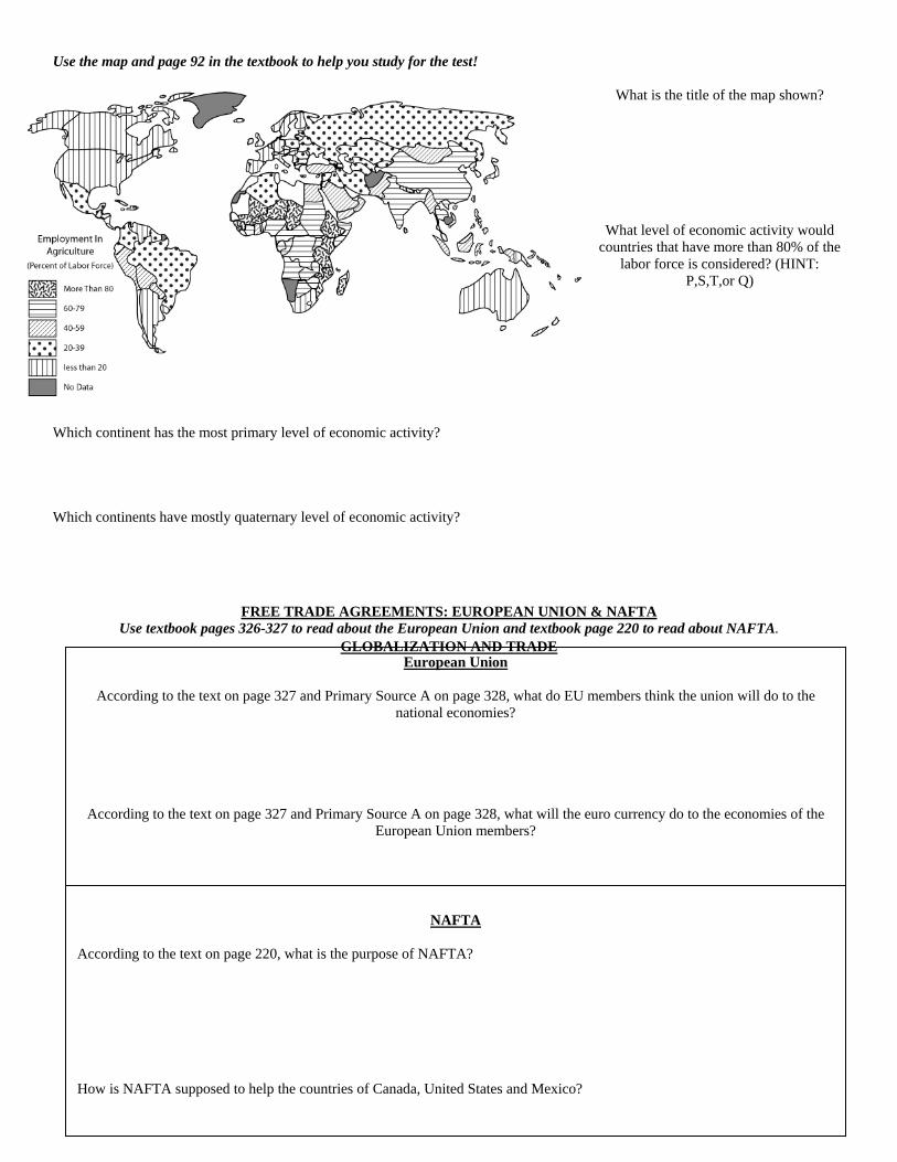
se the map and page 92 in the textbook to help you study for the test!
What is the title of the map shown?
What level of econ ic activity would c
hich continent has the most primary level of economic activity?
hich continents have mostly quaternary level of economic activity?
FREE TRADE AGREEMENTS: EUROPEAN UNION & NAFTA
U
om
ountries that have more than 80% of the labor force is considered? (HINT:
P,S,T,or Q)
W W
Use textbook pages ead about NAFTA. 326-327 to read about the European Union and textbook page 220 to r
GLOBALIZATION AND TRADE
H

Use the textbook page 226 and your knowledge of world geograph o help you study for the test!
ow has the Panama Canal helped with globalization and trade?
ow do American companies use outsourcing to produce products?
se pages 324-325 to read about Industrial Pollution in Europe.
hat types of human activities have caused air pollution in Europe?
hat kind of health problems could the pollution cause?
hat is being done to clean up the air in Europe?
se your notes and the map to help you study about Chokepoints
Looking at the map, which chokepoint is
What would happen t the price of oil if the
What has the production of oil done to the
UNIT 4: POPULATION GEOGRAPHY
y t H H U W W W U
important for the world’s oil supply?
oabove chokepoint was cut off from global
trade?
economies in the Middle East region?

People migrated to San Francisco, CA in 1849 because of the discovery of gold.
A chemical engineer immigrates to Iraq to work in the oil industry.
Pittsburgh Steelers are named after the
cities in
mining and steel production during the Industrial Revolution. Pittsburgh, Pennsylvania is one of the larges Pennsylvania.
ook at the maps on pages 614- 615 in the textbook and your knowledge of world geography to study for the test!
hat region in China has the highest concentration of population?
hy are there few people on the opposite side of China than from the above question?
hy would the government of China want to instate the One Child Policy? (pg 639)
se the speaker boxes to help you understand population distribution.
What physical features influenced where the people in the speaker
hy would people settle near these physical features?
ow can cultures be influenced by our location?
se the chart to help you study population trends over time.
w would you describe the world population between the years
reasons could have caused the rapid increase of world
are some negative consequences if the world population
L W W W U
boxes settled? W H
U
Ho1750-1850? Whatpopulation between the years 1950-2000? Whatcontinues to increase?
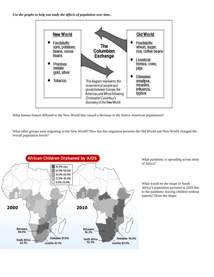
Use the graphs to help you study the affects of population over time.. What human feature diffused to the New World that caused a decrease in the Native American populations? What other groups were migrating to the New World? How has this migration between the Old World and New World changed the overall population levels?
What pandemic is spreading across most of Africa? What would be the shape of South Africa’s population pyramid in 2010 duto the pandemic leaving children wiparents? Draw the shape:
e thout

Use page 79 in your textbook and the population pyramids to help you study for the test! What is the purpose of a population pyramid? Draw each shape of the different population growths: INCREASING GROWTH STEADY GROWTH DECREASING GROWTH What type of prediction can be made about this country’s population in the future? What type of population policy would this country need?

Use the textbook, your notes, and your knowledge of world geography to define the following words:
GEOTERM DEFINITION
Human Process
Physical Process
Deforestation
Erosion
Diffusion
Deforestation
Scarcity
Self-Sufficiency
Ethnocentrism
Sustainable Development
Globalization
Protectionism
Free Trade Agreement
Geographic Information System
Global Positioning System
Arable Land/Rural
Urbanization
Migration
Glaciations
Polder
Permafrost