Name of Project: Conasauga Tributaries Project Phase 2
7
ATTACHMENT B Watershed Based Plan Name of Project: Conasauga Tributaries Project Phase 2 Lead Organization: Southeast Tennessee Resource Conservation and Development Council (SETNRCD) will provide overall leadership in this project. Partners including the Natural Resources Conservation Services (NRCS) and county groundwater specialists will provide technical assistance when necessary. The Project Manager for this initiative will be Robert Altonen, Watershed Project Coordinator with the SETNRCD who has worked on several 319 grants throughout the region his contacting information is 423-762-0152 or email at [email protected]. Assisting Robert will be Simone Madsen, the current Executive Director of the nonprofit as well as the previous Watershed Project Coordinator. Her contact information is 423-322-4405 or [email protected]. Watershed Identification (name, location, 12-digit HUC, etc.): Watershed name: Conasauga River HUC: 0315010101 Impaired Segments (TDEC 2012) Ball Play (7.4 Miles) Polk County Waterbody ID: TN 03150101012-0200 Mill Creek (20.1 miles) Bradley County Waterbody ID: TN 031501012-0100 Exceptional State Waters Coahulla Creek (State line to headwaters) Bradley County Waterbody ID: TN 031501012-0100
Transcript of Name of Project: Conasauga Tributaries Project Phase 2

ATTACHMENT B
Watershed Based Plan
Name of Project: Conasauga Tributaries Project Phase 2
Lead Organization: Southeast Tennessee Resource Conservation and Development Council (SETNRCD) will provide overall leadership in this project. Partners including the Natural Resources Conservation Services (NRCS) and county groundwater specialists will provide technical assistance when necessary. The Project Manager for this initiative will be Robert Altonen, Watershed Project Coordinator with the SETNRCD who has worked on several 319 grants throughout the region his contacting information is 423-762-0152 or email at [email protected]. Assisting Robert will be Simone Madsen, the current Executive Director of the nonprofit as well as the previous Watershed Project Coordinator. Her contact information is 423-322-4405 or [email protected].
Watershed Identification (name, location, 12-digit HUC, etc.): Watershed name: Conasauga River HUC: 0315010101 Impaired Segments (TDEC 2012) Ball Play (7.4 Miles) Polk County Waterbody ID: TN 03150101012-0200 Mill Creek (20.1 miles) Bradley County Waterbody ID: TN 031501012-0100 Exceptional State Waters Coahulla Creek (State line to headwaters) Bradley County Waterbody ID: TN 031501012-0100

Causes and Sources of Nonpoint Source Pollution in the Watershed Mill Creek and Ball Play Creek in the Conasauga watershed are listed in the 2014 303(d) List published by the Tennessee Department of Environment and Conservation (TDEC). The listed causes of impairment are loss of biological integrity due to Escherichia coli (E. coli) from pasture grazing and septic tanks as the primary pollutant source. Additionally, we have included Coahulla Creek in this plan as exceptional waters due to the presence of a listed species, the Tri Color Darter. Concern of habitat degradation in the Coahulla Creek Watershed was raised at a 2008 meeting with the Conasauga River Alliance who suggested we work on improving the water quality of the creek to ensure the safety of the species. Ball Play Creek has a total area of 3,183 acres with 1,084 of those acres within a 300-foot buffer of the creek itself. As of 2008 there are two listed livestock operations within that 300-foot stream buffer. 145 acres of agricultural and 10 acres of residential land use is in the watershed itself (TDEC 2005 TMDL), according to the Conasauga River Alliance 2008 meeting there are 653 acres of agricultural land use and 161 acres of residential land use in the 300-foot stream buffer zone. There are a total of 87,165 livestock (48 excluding poultry) and 151 residents. The Mill Creek sub watershed has a total acreage of 15,610 with 4,609 acres within the 300-foot buffer zone. There are 42 livestock operations and 209 wastewater sources. TDEC 2005 TMDLs show 5,586 acres dedicated to agricultural use and 129 acres dedicated to residential and commercial. According to the Conasauga River Alliance there is a total of 2,484,590 livestock with 1,630 excluding poultry as well as 2,672 people. Within the 300-foot stream buffer there is 3,140 acres of agricultural use and 927 acres for residential and commercial. The Coahulla Creek sub watershed has a total acreage of 36,758 acres and 4,355 acres within the 100-foot buffer zone. There is a total of 51 livestock operations and 283 domestic wastewater sources. Land use within the buffer zone is 2,070 acres of agriculture, 603 acres of farm, and 1,137 acres of residential and commercial based on tax parcel data.
Estimate of Load Reductions The primary cause of the 303(d) listing of these creeks is E. coli contamination, and as such our BMPs will focus on reducing just that. With the severe droughts, we have been having in the area, much of the pasture may be damaged with soil exposed. We are planning to do a number of forage and biomass planting in fields as both an incentive for farmers to work with us as well as a way to reduce the amount of sediment and runoff being flushed into streams. Practice Code
Practice Name Unit Amount Lbs./N Per Year
Lbs./P Per Year
Tons of Sediment Per Year
614 Watering System
Lbs. /N/Unit/Year
15 1,053.45 88.2 .006
561 Heavy Use Area
Lbs. /N/sqft/Year
12,940 sq/ft
1,164.6 129.4 25.88
516 Pipeline Lbs. /N/foot/Year
7,000 910 140 42
382 Fence Lbs. /N/foot/Year
20,500 ft 5,125 410 123
512 Forage and Biomass Planting
Lbs. /N/acre/Year
300 acres 2,034 198 52.5
006 Septic Improvements
Lbs N/unit/year
25 2,982 314.5 89.1
Total 13,269.05 1,280.1 332.486 .
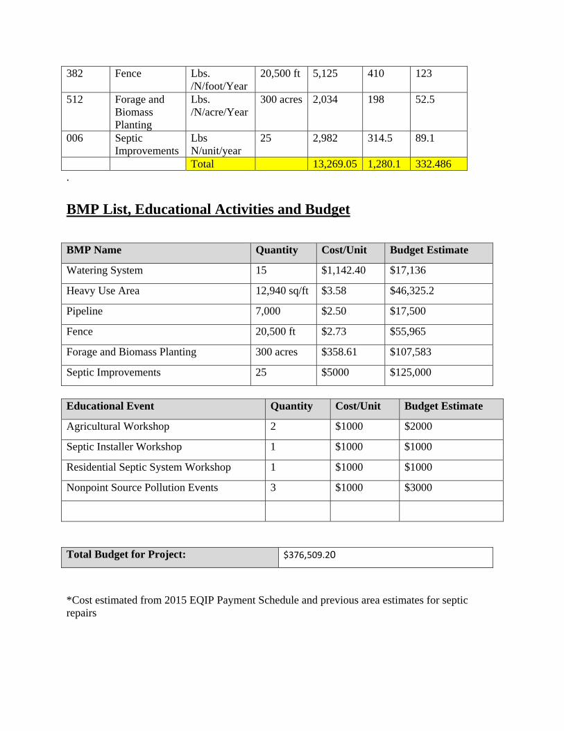
BMP List, Educational Activities and Budget BMP Name Quantity Cost/Unit Budget Estimate
Watering System 15 $1,142.40 $17,136
Heavy Use Area 12,940 sq/ft $3.58 $46,325.2
Pipeline 7,000 $2.50 $17,500
Fence 20,500 ft $2.73 $55,965
Forage and Biomass Planting 300 acres $358.61 $107,583
Septic Improvements 25 $5000 $125,000
Educational Event Quantity Cost/Unit Budget Estimate
Agricultural Workshop 2 $1000 $2000
Septic Installer Workshop 1 $1000 $1000
Residential Septic System Workshop 1 $1000 $1000
Nonpoint Source Pollution Events 3 $1000 $3000
Total Budget for Project: $376,509.20
*Cost estimated from 2015 EQIP Payment Schedule and previous area estimates for septic repairs

Timeline, Tasks, and Assessment of Progress Within the first two months we will reach out to farmers who were previously interested in the grant that were either too late in getting assistance or may wish to continue on their conservation plan initiated by the NRCS. In the first three months, we plan to have one of the farmer workshops, this is especially important to advertise the forage and biomass BMPs in a timely fashion to meet planting time tables as the recent severe drought has caused quite a bit of damage to grazing fields. Another farmer BMP workshop will be done in the next year. The workshop with septic installers and residents will be done within the first six months. We are planning to do at minimum 25 septic system repairs, however this may change if we get an increased amount of interest – we may reduce the cost share to accommodate for interest. Progress will be measured month to month with the nonprofit’s board overseeing and approving vouchers and project coordinator’s work. Every fiscal quarter we will send in quarterly reports as required by the state, alongside financial reimbursement requests unless we require them on a more immediate basis. On September 15th of every year we will submit to the state a document summarizing our work containing four separate photos called “4x4s”. At the end of the grant cycle we will publish our close out report which will contain a summary of what we have done, problems that we have encountered, and how, in the future, those problems could be avoided.
Criteria to Assess Achievement of Load Reduction Goals We will work with TDEC and ground water specialists in order to measure the improvements that our practices have made. We will provide a list of the locations and BMPs implemented, and see after all installations have been made if water quality has been improved. These results will be seen in any future TMDL or 303(d) listings or delistings. Additionally, these BMPs will have an estimated load reduction as seen in the Estimated Load Reduction section of this Watershed Based Plan which uses information provided in the FY2017 319 RFP for constructing these plans.
Monitoring and Documenting Success Success of this project is based off of the BMPs installed which are known to reduce the amount of E. coli contamination in the creek. Additionally, we will also see reduction in erosion and sedimentation in the creek as consequence of installing these BMPs – both of which are important in the case of the state listed Tri Color Darter, as well as overall water quality. We will submit all records to the state office detailing BMPs installed as well as their location. Additionally, we are working Limestone Valley RC&D in coordinating across state lines with a 319 project in the same watershed. We will share any information needed with one another in order to have a more complete watershed based plan.