MVP USACE Individual Permit Application
107
Mountain Valley Pipeline Project Individual Permit Application Prepared for: Mountain Valley Pipeline, LLC 2200 Energy Drive, Canonsburg, Pennsylvania 15317 Prepared by: Tetra Tech, Inc. 661 Andersen Drive, Pittsburgh, Pennsylvania 15220 Submitted to: United States Army Corps of Engineers – Pittsburgh District 1000 Liberty Avenue, Suite 2200, Pittsburgh, PA 15222 United States Army Corps of Engineers – Huntington District 502 Eighth Street, Huntington, WV 25701-2070 United States Army Corps of Engineers – Norfolk District 803 Front Street, Norfolk, VA 23510-1011 Virginia Department of Environmental Quality 1111 E Main Street, Richmond, VA 23219 Virginia Marine Resources Commission 380 Frenwick Road, Fort Monroe, VA 23651 February 2021
Transcript of MVP USACE Individual Permit Application
Mountain Valley Pipeline Project Individual Permit Application Prepared for:
Mountain Valley Pipeline, LLC
2200 Energy Drive, Canonsburg, Pennsylvania 15317
Prepared by:
Tetra Tech, Inc.
661 Andersen Drive, Pittsburgh, Pennsylvania 15220
Submitted to:
United States Army Corps of Engineers – Pittsburgh District
1000 Liberty Avenue, Suite 2200, Pittsburgh, PA 15222
United States Army Corps of Engineers – Huntington District
502 Eighth Street, Huntington, WV 25701-2070
United States Army Corps of Engineers – Norfolk District
803 Front Street, Norfolk, VA 23510-1011
Virginia Department of Environmental Quality
1111 E Main Street, Richmond, VA 23219
Virginia Marine Resources Commission
380 Frenwick Road, Fort Monroe, VA 23651
February 2021

Mountain Valley Pipeline Project USACE Individual Permit Application
February 2021
Tetra Tech Page i
TABLEOFCONTENTSSection Page
PROJECT INFORMATION .............................................................................................................. 1 Preliminary Jurisdictional Determination and USACE Individual Permit Application
Forms ............................................................................................................................. 1 Project Description and History ..................................................................................... 1 General Construction Information .................................................................................. 3
1.3.1 Pipeline Construction Description .......................................................................... 3 1.3.2 Access Road Construction Description .................................................................. 4
Project Location ............................................................................................................. 4 Watersheds and Hydrologic Unit Codes ........................................................................ 4 Property Owners ............................................................................................................ 4 Request for Expedited Consideration ............................................................................ 4 Directions to Site ............................................................................................................ 5 Project Authorizations .................................................................................................... 6
1.9.1 Authorizations and Approvals ................................................................................. 6 1.9.2 Clean Water Act § 401 Water Quality Certification ................................................ 6 1.9.3 National Historic Preservation Act § 106 Consultation .......................................... 6 1.9.4 Endangered Species Act § 7 Consultation ............................................................. 7 1.9.5 Inapplicable Authorizations and Approvals ............................................................ 8
Project Schedule ............................................................................................................ 8
PROJECT PURPOSE AND NEED ................................................................................................ 10 Basic Project Purpose ................................................................................................. 10 Overall Project Purpose ............................................................................................... 10 Overall Project Need .................................................................................................... 10
ALTERNATIVES ANALYSIS ......................................................................................................... 11 FERC’s Environmental Impact Statement ................................................................... 11 Alternatives Analysis .................................................................................................... 13
3.2.1 No Action (No Build) Alternative ........................................................................... 14 3.2.2 No Action (No Permit) Alternative ........................................................................ 14 3.2.3 Natural Gas Transportation Method Alternatives Analysis .................................. 16 3.2.4 System Alternatives .............................................................................................. 19 3.2.5 Route Alternatives ................................................................................................ 21 3.2.6 Route Alternatives Considered Not Practicable ................................................... 23
AFFECTED ENVIRONMENT AND ENVIRONMENTAL REVIEW FACTORS .............................. 33 Proposed Aquatic Impacts ........................................................................................... 33
4.1.1 Jurisdictional Impacts ........................................................................................... 33 4.1.2 Section 10 Waters ................................................................................................ 33 4.1.3 Wetland Delineation and Stream Identification .................................................... 34 4.1.4 Water Withdrawals ............................................................................................... 35
Sensitive Stream Resources ....................................................................................... 35 4.2.1 National Wild and Scenic Rivers .......................................................................... 35 4.2.2 WV Natural Streams Preservation Act ................................................................. 35 4.2.3 Tier 3 Protection ................................................................................................... 35 4.2.4 Trout Waters ......................................................................................................... 35 4.2.5 Warm Water Fishery ............................................................................................ 36 4.2.6 Anadromous Fish Use Areas ............................................................................... 36 4.2.7 Aquatic Life Movements ....................................................................................... 36 4.2.8 Spawning Areas ................................................................................................... 36 4.2.9 Submerged Aquatic Vegetation............................................................................ 36
Mountain Valley Pipeline Project USACE Individual Permit Application
February 2021
Tetra Tech Page ii
4.2.10 Freshwater Mussels ............................................................................................. 37 4.2.11 Designated Critical Resource Waters .................................................................. 37
404(b)(1) Guidelines Technical Evaluation Factors ..................................................... 37 4.3.1 Substrate (§ 230.20) ............................................................................................. 37 4.3.2 Suspended Particles/Turbidity (§ 230.21) ............................................................ 37 4.3.3 Water (§ 230.22) .................................................................................................. 37 4.3.4 Current Patterns and Water Circulation (§ 230.23) .............................................. 38 4.3.5 Normal Water Fluctuations (§ 230.24) ................................................................. 38 4.3.6 Salinity Gradients (§ 230.25) ................................................................................ 38 4.3.7 Threatened and Endangered Species § (230.30) ................................................ 38 4.3.8 Fish, Crustaceans, Mollusks, and Other Aquatic Organisms in Food Web (§ 230.31) 38 4.3.9 Other Wildlife (§ 230.32) ...................................................................................... 38 4.3.10 Sanctuaries and Refuges (§ 230.40) ................................................................... 38 4.3.11 Wetlands (§ 230.41) ............................................................................................. 39 4.3.12 Mud Flats (§ 230.42) ............................................................................................ 39 4.3.13 Vegetated Shallows (§ 230.43) ............................................................................ 39 4.3.14 Riffle and Pool Complexes (§ 230.45) ................................................................. 39 4.3.15 Municipal and Private Water Supplies (§ 230.50) ................................................ 39 4.3.16 Recreational and Commercial Fisheries (§ 230.51) ............................................. 39 4.3.17 Water-Related Recreation (§ 230.52) .................................................................. 40 4.3.18 Aesthetics (§ 230.53) ........................................................................................... 40 4.3.19 Parks, National and Historical Monuments, National Seashores, Wilderness Areas, Research Sites and Similar Preserves (§ 230.54) ................................................ 40 4.3.20 General Evaluation of Dredged or Fill Material (§§ 230.60, 230.61) .................... 40 4.3.21 Actions concerning the location of the discharge (§ 230.70) ............................... 40 4.3.22 Actions concerning the material to be discharged (§ 230.71) .............................. 40 4.3.23 Actions controlling the material after discharge (§ 230.72) .................................. 40 4.3.24 Actions affecting the method of dispersion (§ 230.73) ......................................... 40 4.3.25 Actions related to technology (§ 230.74) .............................................................. 41 4.3.26 Actions affecting plant and animal populations (§ 230.74) .................................. 41 4.3.27 Actions affecting human use (§ 230.76) ............................................................... 41 4.3.28 Other actions (§ 230.77) ....................................................................................... 41
Public-Interest Review Factors .................................................................................... 41 4.4.1 Conservation (§ 320.4(a)) .................................................................................... 41 4.4.2 Economics (§ 320.4(a)) ........................................................................................ 42 4.4.3 Aesthetics (§ 320.4(a)) ......................................................................................... 42 4.4.4 General Environmental Concerns (§ 320.4(a)) .................................................... 42 4.4.5 Wetlands (§ 320.4(a) & (b)) .................................................................................. 42 4.4.6 Historic, Cultural, Scenic, and Recreational Values (§ 320.4(a) & (e)) ................ 43 4.4.7 Fish and Wildlife Values (§ 320.4(a) & (c)) .......................................................... 43 4.4.8 Floodplain Hazards, Values, and Management (§ 320.4(a) & (l)) ........................ 43 4.4.9 Land Use (§ 320.4(a)) .......................................................................................... 44 4.4.10 Navigation (§ 320.4(a) & (o)) ................................................................................ 44 4.4.11 Shore Erosion and Accretion (§ 320.4(a)) ............................................................ 44 4.4.12 Water Supply and Conservation (§ 320.4(a) & (m)) ............................................. 44 4.4.13 Water Quality (§ 320.4(a) & (d)) ........................................................................... 45 4.4.14 Energy Needs, Energy Conservation and Development (§ 320.4(a) & (n)) ......... 46 4.4.15 Safety (§ 320.4(a)) ............................................................................................... 46 4.4.16 Food and Fiber Production (§ 320.4(a)) ............................................................... 46 4.4.17 Mineral Needs (§ 320.4(a)) .................................................................................. 46 4.4.18 Consideration of Property Ownership (§ 320.4(a) & (g)) ..................................... 46 4.4.19 Needs and Welfare of the People (§ 320.4(a)) .................................................... 47 4.4.20 Effects on Limits of the Territorial Sea (§ 320.4(f)) .............................................. 47
Mountain Valley Pipeline Project USACE Individual Permit Application
February 2021
Tetra Tech Page iii
4.4.21 Activities Affecting Coastal Zones (§ 320.4(h)) .................................................... 47 4.4.22 Activities in Marine Sanctuaries (§ 320.4(h)) ....................................................... 47 4.4.23 Other Federal, State, or Local Requirements (§ 320.4(j)) .................................... 47 4.4.24 Safety of Impoundment Structures (§ 320.4(k)) ................................................... 47 4.4.25 Environmental Benefits (§ 320.4(p)) .................................................................... 47 4.4.26 Mitigation (§ 320.4(r)) ........................................................................................... 48
MITIGATION .................................................................................................................................. 49 Avoidance .................................................................................................................... 49
5.1.1 Avoidance and Minimization by Selection of Pipeline Crossing Method ............. 49 5.1.2 Avoidance Through Alignment Selection ............................................................. 63 5.1.3 Avoidance Through ROW Configuration .............................................................. 63 5.1.4 Site-Specific Onsite Avoidance Measures ........................................................... 63 5.1.5 Avoidance Actions Dictated by Other Authorities ................................................. 64
Minimization ................................................................................................................. 64 5.2.1 Instream Pipeline Construction Practices ............................................................ 64 5.2.2 Wetland Pipeline Construction Practices ............................................................. 64 5.2.3 Duration of Pipeline Construction Activities in Waters ......................................... 64 5.2.4 Construction Practices Adjacent to Aquatic Resources ....................................... 64 5.2.5 Stream Crossing Geometry .................................................................................. 65 5.2.6 Time-of-Year Restrictions ..................................................................................... 65 5.2.7 Wetland and Stream Crossings in ATWS ............................................................ 65 5.2.8 Restoration of Temporary Wetland Impacts ......................................................... 65 5.2.9 Restoration of Temporary Stream Impacts (Pipeline) .......................................... 66 5.2.10 Long Term ROW Maintenance in Wetlands ......................................................... 67
Compensation .............................................................................................................. 67
PUBLIC INVOLVEMENT ............................................................................................................... 69
FIGURESFigures
Figure 1 Project Overview Map Figure 2 Pipeline Activities Progress Map Figure 3 USGS Project Location Map Figure 4 Detail Map Figure 5 USACE Norfolk District Wetland and Waterbodies Overview Map

Mountain Valley Pipeline Project USACE Individual Permit Application
February 2021
Tetra Tech Page iv
TABLESTables
Table 1 Section 10 River Crossings Table 2 Stream Impacts Table 3 Wetland Impacts Table 4 Stream Crossings Summary Table 5 Wetland Crossings Summary Table 6 Counties and Towns Crossed by the Project Table 7 Watersheds Crossed by the Project Table 8 List of Affected Landowners Table 9 State and Federal Permit Status Table 10 Completed Project Crossings Table 11 Completed Station and Interconnect Crossings Table 12 Stockpile Data Table 13 Dry-Ditch Open-Cut Crossing Method Cost Table 14 Bore Crossing Method Cost Table 15 Crossing Method Determination Summary Table 16 Streams and Wetlands Avoided at the Direction of Other Federal or State Authorities Table 17 Wetland Mitigation Table 18 Stream Mitigation
ATTACHMENTS Attachments
Attachment A WV DEP 401 Water Quality Certification Information Attachment B VA DEQ 401 Water Quality Certification Information and Virginia Water
Protection Permit Application Attachment C Virginia Marine Resources Commission Permit Modification Request
and Materials Attachment D USACE Pittsburgh District ENG Form 4345 Attachment E USACE Huntington District ENG Form 4345 Attachment F USACE Norfolk District Standard JPA Form Attachment G FERC Weekly Status Report Attachment H Plan and Profile Crossing Drawings and Inadvertent Return Plan Attachment I Wetland and Stream Data Forms and Photographs Attachment J Construction Details Attachment K Karst Mitigation Plan Attachment L Examples of Completed Project Stream and Wetland Restoration Attachment M Compensatory Mitigation

Mountain Valley Pipeline Project USACE Individual Permit Application
February 2021
Tetra Tech Page v
TABLEOFACRONYMSANDKEYABBREVIATIONS
APE Area of Potential Effect
ATWS additional temporary workspace
BLM Bureau of Land Management
BMP best management practice
2020 BiOp 2020 Biological Opinion
CWA Clean Water Act
DWWM West Virginia DEP Division of Water and Waste
ECD erosion control devices
EPA United States. Environmental Protection Agency
ESA Endangered Species Act
ESCP erosion and sediment control plan
FEIS Final Environmental Impact Statement
FERC Federal Energy Regulatory Commission
HDD horizontal directional drill
IP Individual Permit
IR inadvertent return
JPA Joint Permit Application
LDC Local Distribution Company
LEDPA Least Environmentally Damaging Practicable Alterntaive
LNG liquified natural gas
LOD limits of disturbance
MTBM microtunnel boring machine
MP Milepost
NEPA National Environmental Policy Act
NFS National Forest System
NSPA West Virginia Natural Streams Preservation Act
NWP Nationwide Permit
PCN Pre-Construction Notification
PEM palustrine emergent wetland
PFO palustrine forested wetland
PHMSA Pipeline and Hazardous Materials Safety Administration
PJD Preliminary Jurisdictional Determination

Mountain Valley Pipeline Project USACE Individual Permit Application
February 2021
Tetra Tech Page vi
Project Mountain Valley Pipeline Project
PSD Red Sulphur Public Service District
PSS palustrine scrub-shrub wetland
RHA Rivers and Harbors Act of 1899
ROW Right-of-Way
SEIS USFS Supplemetal Environmental Impact Statement
SWVM West Virginia Stream and Wetland Valuation Metric
TOYR time-of-year restriction
USACE U.S. Army Corps of Engineers
US EIA United States Energy Information Administration
USFS U.S. Forest Service
USFWS U.S. Fish and Wildlfe Service
USM Unified Stream Methodology
VA DEQ Virginia Department of Environmental Quality
VDWR Virginia Department of Wildlife Resources
VMRC Virginia Marine Reosources Commission
VWP Virginia Water Protection Pemit Program
WOTUS Waters of the United States
WQC Clean Water Act § 401 Water Quality Certification
WV DEP West Virginia Department of Environmental Protection
WV DNR West Virginia Department of Natural Resources

Mountain Valley Pipeline Project USACE Individual Permit Application
February 2021
Tetra Tech Page 1
PROJECT INFORMATION Mountain Valley Pipeline, LLC (Mountain Valley1) is seeking an Individual Permit (IP) from the United States Army Corps of Engineers (USACE or Corps) Pittsburgh, Huntington, and Norfolk Districts to conduct regulated activities below the ordinary high-water elevation of navigable waters under Section 10 of the Rivers and Harbors Act of 1899 (RHA) and for the discharge of dredged and fill material into Waters of the United States (WOTUS) under Section 404 of the Clean Water Act (CWA) for the Mountain Valley Pipeline Project (Project). In addition to the USACE IP Application, Mountain Valley is seeking CWA Section 401 Water Quality Certification (WQC) from the West Virginia (WV) Department of Environmental Protection (DEP) and the Virginia (VA) Department of Environmental Quality (DEQ) for portions of the Project within their respective jurisdiction (See Section 1.9.2 below).
Additionally, this application package provides information to support CWA § 401 Water Quality Certification (WQC) determinations by West Virginia (Attachment A) and Virginia (Attachment B). Requests for WQC will be submitted separately. This package also includes an application for a Virginia Water Protection (VWP) permit (included in Attachment B) and a request to modify Mountain Valley’s Virginia Marine Resources Commission permit (included in Attachment C).2
Preliminary Jurisdictional Determination and USACE Individual Permit Application Forms
Mountain Valley will be relying on existing Preliminary Jurisdictional Determinations by the USACE Huntington, Pittsburgh, and Norfolk Districts identifying the potential presence of WOTUS in the Project limit of disturbance (LOD) located in their respective USACE Districts.
The completed Applications for Department of the Army Permit (ENG Form 4345) for the Project are included in Attachment D for WOTUS located within the USACE Pittsburgh District; Attachment E for the WOTUS within the USACE Huntington District; and Attachment F for the WOTUS within the Norfolk District.
Additional Project information is provided below and in the attached documents.
Project Description and History Mountain Valley is constructing a pipeline approximately 304 miles in length and 42 inches in diameter to provide timely and affordable access to natural gas, which is in growing demand. The Project begins at an existing Equitrans, L.P. transmission system near the Mobley natural gas processing facility in Wetzel County, West Virginia and extends to the Transcontinental Gas Pipe Line Company, LLC’s (Transco) Zone 5 Compressor Station 165 in Transco Village, Pittsylvania County, Virginia (Figure 1). In addition to delivering natural gas to the Transco interconnect (Milepost (MP) 303.9), the Project is designed to deliver gas to four intermediate delivery points: WB Interconnect in Braxton County, West Virginia (MP 77.3); Greene Interconnect in Monroe County, West Virginia (MP 180.7); Roanoke Gas Lafayette Tap in Montgomery County, Virginia (MP 235.6); the Roanoke Gas Franklin Tap in Franklin County, Virginia (MP 261.4). To date, more than 256 miles of the pipe is laid, and more than 155 miles of land along the pipeline ROW is in final restoration and the three compressor stations (Bradshaw, Harris, and Stallworth Compressor Stations) are complete.
1 Mountain Valley is a joint venture between EQM Midstream Partners, LP; NextEra Capital Holding, Inc; Con Edison Transmission, Inc.; WGL Midstream; and RGC Midstream, LLC.
2 Virginia State Water Control Board regulations require that applications for impacts to state waters be submitted using the Norfolk District’s JPA form. 9 VAC 25-210-80. Applications to VMRC also are submitted through the JPA form.

Mountain Valley Pipeline Project USACE Individual Permit Application
February 2021
Tetra Tech Page 2
The proposed Project crosses portions of three USACE districts: USACE Pittsburgh District, USACE Huntington District, and USACE Norfolk District. Approximately 33 miles of the pipeline and 14 miles of access roads are sited within the USACE Pittsburgh District. Approximately 164 miles of the pipeline, 135 miles of access roads, and three compressor stations (Bradshaw, Harris, and Stallworth Compressor Stations) are sited within the USACE Huntington District. Approximately 107 miles of the pipeline and 51 miles of access roads are sited within the USACE Norfolk District.
In response to Mountain Valley’s pre-construction notification (PCN), USACE Huntington District issued a verification on December 22, 2017, confirming Mountain Valley’s proposed use of nationwide permit (NWP) 12 for the Project (Permit No. LRH-2015-592-GBR). Sierra Club and four other environmental organizations challenged the USACE Huntington District’s verification for the Project in the United States Court of Appeals, Fourth Circuit (Fourth Circuit). By order dated October 2, 2018, and subsequent opinion dated November 27, 2018, the Fourth Circuit vacated the December 22, 2017 verification. See Sierra Club v. U.S. Army Corps of Engineers, 909 F.3d 635 (4th Cir. 2018).
In addition to the USACE Huntington District’s December 22, 2017 verification of the Project, the USACE Pittsburgh District issued a verification for the Project’s use of NWP 12 on December 19, 2017 (Permit No. LRP-2015-798). A Joint Permit Application (JPA) was approved by the USACE Norfolk District on December 26, 2017, (Permit No. NAO-2017-0898) and updated on January 23, 2018, for portions of the Project within Virginia. On October 5 and 19, 2018, the USACE Norfolk and Pittsburgh Districts, respectively, suspended their verifications. The USACE Pittsburgh and Huntington Districts issued new verifications on September 25, 2020. The USACE Norfolk District unsuspended the Project’s NWP 12 verification in that district on the same date. The USACE Huntington and Pittsburgh Districts’ respective verifications on September 25, 2020, are presently stayed, pending appeal in the Fourth Circuit. As a result of the stays of the USACE Huntington and Pittsburgh District verifications, the USACE Norfolk District suspended the Project’s NWP 12 verification in that district.
The USACE’s current NWPs were issued in January 2017 for a five-year period. The USACE was not expected to re-issue or modify its NWPs until 2022. However, in September 2020, the USACE proposed to re-issue and modify its NWPs, including NWP 12. On January 5, 2021, the USACE announced that it had finalized its decision to re-issue some of the NWPs a year earlier than originally planned. On January 13, 2021, the USACE published the new NWPs, including NWP 12, in the Federal Register. Those new permits were scheduled to take effect on March 15, 20213. Although existing NWP authorizations generally allow activities authorized under the 2017 NWPs to continue until March 18, 2022, after that date unfinished activities would need a new authorization or permit. Mountain Valley plans to complete all USACE-regulated activities before March 2022, but the current judicially imposed stay of its existing NWP authorization will shorten the time available to Mountain Valley to complete activities before that date. Accordingly, to avoid the uncertainty created by both the outstanding challenge to its NWP authorization and the USACE’s action to shorten the duration of that authorization, Mountain Valley has elected to seek an Individual Permit (IP) rather than relying on its NWP 12 verifications. Although Mountain Valley firmly believes that the respective NWP 12 verifications issued by the USACE districts in September 2020 were lawful and that the pending legal challenges to those verifications are unfounded, Mountain Valley will be submitting a separate request
3 86 Fed. Reg. 2744 (Jan. 13, 2021). However, there is some uncertainty as to whether the 2021 NWP 12 will take effect on March 15. The Biden Administration issued a memorandum on January 20, 2021, directing agencies to consider whether to suspend the effective date of regulations that had been published in the Federal Register but had not yet become effective. R. Klain, Memo. for the Heads of Exec. Dep’ts and Agencies (Jan. 20, 2021). A second document titled “Fact Sheet: List of Agency Actions for Review” and issued by the Administration the same day specifically identified the 2021 NWP action as an action that should be reviewed in accordance with Section 1 of President Biden’s Executive Order on Protecting Public Health and the Environment and Restoring Science to Tackle the Climate Crisis (Jan. 20, 2021). For these and other reasons, the Individual Permit process provides a greater degree of regulatory certainty at this time than the NWP 12 process.

Mountain Valley Pipeline Project USACE Individual Permit Application
February 2021
Tetra Tech Page 3
to the USACE Pittsburgh, Huntington, and Norfolk Districts to administratively revoke the previously NWP 12 verifications for the Project.
Pre-application meetings regarding this IP application for the Project were held between representatives of Mountain Valley and the USACE Huntington, Pittsburgh, and Norfolk Districts on January 14, 22, and 28, 2021. Representatives for each district were present at all three meetings.
Pre-application meetings regarding this IP application and subsequent state applications were held with representatives from the VMRC (February 2, 2021), VADEQ (February 2, 2021), and WVDEP (February 8, 2021)
General Construction Information
1.3.1 Pipeline Construction Description
In uplands, the pipeline will generally require a 125-foot-wide construction right of way (ROW), which includes a 50-foot-wide permanent ROW. The additional temporary ROW will be necessary for the safe travel of construction and maintenance vehicles and equipment as well as stockpiling any additional material that may be encountered during trenching. Cathodic ground beds and mainline valves will also be located within project’s ROW.
Additional temporary workspace (ATWS) areas will be required for construction activities requiring space outside the 125-foot-wide construction ROW. The ATWS will be utilized during construction for material storage, storage of excess spoil at crossings, parking, and equipment turning radius.
The availability of previously used roads and other existing roads is sufficient to provide access to most work areas. However, new access roads are required in several locations that do not parallel existing road infrastructure. Maintenance will be required on some of the existing roads prior to hauling construction equipment and materials. Maintenance is considered to be the placement of additional gravel or stone on the existing road and the replacement of ineffective or undersized culverts. Some leveling may be required to eliminate ruts on existing access roads.
Mountain Valley will use contractor yards during construction to stage construction equipment, store materials, and set up temporary construction offices. Depending upon the condition of these yards and their current use, some surface grading, drainage improvements, placement of surface materials (e.g., crushed rock), and internal roadways may be required.
Pipeline construction through jurisdictional waters will be accomplished using either conventional dry-ditch open-cut methods or trenchless methods. For open-cut crossings, hydrological conditions along the construction corridor will likely dictate the use of either open-ditch lay or open-ditch push/pull lay methods. The conventional open-ditch lay method will be the most frequently used open-cut crossing technique for installing the pipeline in wetlands and streams. Selection of the push/pull method will be decided during construction by the construction supervisor and/or the Mountain Valley representative. Wetlands within the construction corridor that will not be crossed by the pipeline will be timber matted to protect impact to the wetland or avoided with erosion and sediment controls. Once construction is complete, the timber mats will be removed as soon as practicable and the affected areas will be de-compacted and returned to pre-construction elevations to the extent practicable.
Cleanup and restoration will commence as soon as practicable following the completion of backfilling and testing. Cleanup and restoration activities include restoring grade cuts as close as practicable to preconstruction contours, with stockpiled topsoil re-spread and decompacted—followed by seeding with a regional native seed mix, fertilizing, and mulching to restore ground cover, minimize erosion, and stabilize stream banks for their natural reversion toward their previous state. Completed stream crossings using the flume or dam-and-pump methods will be stabilized before returning flow to the channel. Where the flume technique is used, stream banks will be stabilized before removing the flume pipes and returning flow to the stream channel. Stream banks and bed will be restored as described above for surface water and groundwater flow and mulch, jute thatching, or bonded fiber blankets will be installed on the stream banks.

Mountain Valley Pipeline Project USACE Individual Permit Application
February 2021
Tetra Tech Page 4
A more detailed description of stream and wetland restoration can be found in Sections 5.2.8 (Restoration of Temporary Wetland Impacts [Pipeline]) and 5.2.9 (Restoration of Temporary Stream Impacts [Pipeline]).
1.3.2 Access Road Construction Description
Mountain Valley will utilize existing roads and newly constructed roads to facilitate construction. Typical road widths will be 25 feet but may require additional temporary widening to facilitate use by large equipment, pipe delivery trucks, and installation of erosion and sediment controls. Existing roads will be maintained with minor grading and gravel dressing (as needed) to maintain the road surface. Temporary erosion and sediment controls will be installed in accordance with the state-approved erosion and sediment control plans (ESCP). For existing roads that will need to be temporarily widened for use or that require waterbody crossing culverts to be replaced due to condition, Mountain Valley will either span the waterbody to avoid impact or, where necessary, install a culverted crossing. Culverts will be countersunk as appropriate and will be sized and installed in a manner to maintain low flows to allow the passage of aquatic life and to freely pass bankfull flows.
Following Project completion, existing roads that required temporary widening will be returned to preexisting contours and conditions, unless landowners have requested the widening to remain. Any drainage culverts damaged will be repaired as needed and returned to preexisting conditions. Areas of temporary widening will have the temporary road surface reclaimed and the disturbed areas revegetated. The road surface will be returned to the preexisting width and a topcoat of gravel applied (where necessary). Once disturbed areas are permanently stabilized with vegetation or other measures (e.g., gravel, where applicable), temporary erosion and sediment controls will be removed and properly disposed of at an approved waste disposal site.
Project Location The locations of the proposed Section 10 navigable waters crossings included in this permit application are listed on Table 1. The locations of the proposed stream and wetland WOTUS impacts included in this permit application are listed on Tables 2 and 3, respectively, and summaries of these proposed stream and wetland WOTUS impacts are included in Tables 4 and 5, respectively. Counties and towns crossed by the Project are listed in Table 6. Figure 1-Index and Figures 1-1 to 1-105 show the locations of the crossings included in this permit application.
Watersheds and Hydrologic Unit Codes The watersheds and hydrologic unit codes (HUCs) for the proposed Project crossings included in this permit application are provided in Table 7.
Property Owners A list of property owners for the portions of the Project included in this permit application is included in Table 8.
Request for Expedited Consideration Completion of the Project has been substantially delayed by third-party legal challenges, and the expeditious completion of the Project is overwhelmingly in the public interest. The public has been adversely affected by the delay, which has prevented Mountain Valley from supplying the delivery of reliable, affordable, clean-burning for natural gas that underlies the Project purpose and need. The delays have caused unnecessary environmental impacts. Because of the work stoppages, significant areas of the Project ROW remain in a protracted state of temporarily stabilized construction managed with temporary erosion and sediment controls. Final restoration of the ROW includes restoring disturbed soils and establishing permanent vegetative cover, which are the most effective erosion and sediment controls available. The extended construction period also is a burden on landowners and other members of the public directly affected by Project construction activities in their communities. The best outcome for

Mountain Valley Pipeline Project USACE Individual Permit Application
February 2021
Tetra Tech Page 5
residences and business who are relying on the Project for their natural gas supply and best environmental outcome for water quality, aquatic and terrestrial habitat, and landowners in the vicinity of the Project is for construction to be completed as soon as possible.
Mountain Valley now holds all material approvals necessary to proceed with construction in upland areas. Obtaining authorization to complete the remaining stream and wetland crossings will allow Mountain Valley to expeditiously complete construction, restore the ROW, and commence the transport and supply natural gas.
Through the past several years of permitting actions, the USACE already has considerable familiarity with the Project. The modifications proposed in this application are minor in scope and consist primarily of changes in construction practices that reduce the aquatic impacts previously reviewed by the USACE. In light of these considerations and the urgent public need to complete the Project, Mountain Valley respectfully requests the USACE expedite review of this application in a manner consistent with 33 C.F.R. § 325.2(d).
Directions to Site Directions are provided from the USACE Huntington District, 502 Eighth Street, Huntington, WV 25701-2070 to:
The northern extent of the Project, Project mile post (MP) 0 in Wetzel County, WV, located at 39.562409° North (N), -80.543079° West (W).
o Take Interstate (I)-64 East (E) for approximately 50.4 miles to exit 59 for I-77N
o Continue on I-77N for approximately 1.9 miles to exit 104 for I-79N
o Take I-79N for approximately for approximately 118 miles to exit 119 (US-50 towards Clarksburg/Bridgeport)
o Turn left onto US-50 West (W) and continue on US-50W for approximately 5.9 miles
o Right onto County Road (CR) 5035 and continue for approximately 0.3 mile
o Right onto Wilsonburg Rd and continue for approximately 0.7 mile
o Right onto Bean Run/Gregory Run and continue for approximately 5.8 miles
o Left onto WV-20N and continue for approximately 17.1 miles
o Right onto CR 7/8 and continue for approximately 2.8 miles
o Slight left onto Fallen Timber Rd / Shuman Hill and continue for approximately 2.3 miles
o Left onto N Fork Rd and continue for approximately 0.3 mile
o Right onto CR 15/3 and continue for 0.5 mile to destination
The WV – VA border crossing at Project MP 196.3 in Monroe County, WV, located at 37.402653°N, -80.690013°W
o Take I-64E / I-77 South (S) from Huntington for approximately 114 miles
o Continue on I-77S for approximately 31.6 miles to exit 9 for US-460 toward Princeton / Pearisburg, VA
o Left onto US-460E and continue on US-460E for approximately 14.8 miles
o Left onto Island St
o Left onto US-219N / Federal St
o Follow US-219N for approximately 7.4 miles and turn right onto Wilson Mill Rd
o Follow Wilson Mill Rd for approximately 1.9 miles until destination is reached

Mountain Valley Pipeline Project USACE Individual Permit Application
February 2021
Tetra Tech Page 6
Directions are provided from Roanoke, VA to the southern extent of the Project, Project MP 303.87 in Pittsylvania County, VA, located at 36.833466°N, -79.337119°W
Take VA-116 S/Mt. Pleasant Boulevard SE for approximately 13 miles.
Turn right onto VA-122 S
Turn left onto State Route 670, go 5 miles.
Turn right onto State Route 834, go 7.5 miles.
Turn left onto Turtle Hill Road, go approximately 0.3 miles
Turn left onto VA-40 E, go 16.5 miles
Turn right onto Old Mine Road, go 1.5 miles.
Turn left to stay on Old Mine Road, go 3.7 miles.
Turn right onto US-29 S, go 4 miles
Take the exit toward Chalk Level Road, turn left onto Chalk Level Road, go 2 miles
Turn right onto Transco Road and continue until destination is reached.
Project Authorizations
1.9.1 Authorizations and Approvals
A complete list of all authorizations by federal, interstate, state, and local agencies for the work, including all approvals received or denials already made is summarized in Table 9.4
1.9.2 Clean Water Act § 401 Water Quality Certification
Mountain Valley previously obtained WQC (in Virginia, December 2017) or waivers thereof (in West Virginia, February 2020) for the impacts included in this application concurrently with the NWP 12 verifications discussed in Section 1.2. To ensure compliance with 33 U.S.C. § 1341(a) and 40 C.F.R. § 121.2, Mountain Valley will be submitting new requests for WQC to Virginia and West Virginia. On January 26, 2021, Mountain Valley sent letters to VA DEQ and WV DEP notifying them of Mountain Valley’s intent to submit a WQC request and requesting a pre-filing meeting. Mountain Valley met with the DEQ on February 3, 2021, and with the WV DEP on February 9, 2021. Formal requests for WQC will be submitted to DEQ and DEP no sooner than February 25, 2021.
State-specific information for the VA DEQ 401 WQC is provided in Attachment B. Mountain Valley will provide the WV DEP all necessary information concurrently with the WQC request.
1.9.3 National Historic Preservation Act § 106 Consultation
As part of the Natural Gas Act pipeline certification process, the Federal Energy Regulatory Commission (FERC or Commission) developed a Programmatic Agreement in consultation with the USACE, State Historic Preservation Officers, and others parties, to resolve adverse effects to affected historic properties
4 The Project does not require authorizations or approvals from any interstate agencies. Mountain Valley occasionally conducts regulated activities, such as maintenance of preexisting culverts for landowners, streambank stabilization degraded by natural causes upon the request of relevant agencies or landowners, and water quality monitoring, under applicable NWPs. Those single and complete projects are not included in this application.

Mountain Valley Pipeline Project USACE Individual Permit Application
February 2021
Tetra Tech Page 7
in accordance with 36 C.F.R. § 800.14(b)(3).5 Mountain Valley will adhere to the requirements of the Programmatic Agreement for all work conducted under the proposed permit authorization, including the previously approved plan for unanticipated historic properties and human remains.
There are no potential direct or indirect effects to historic properties subject to USACE’s permit area that warrant reinitiating consultation under Section 106. The “permit areas” (as that term is defined in 33 C.F.R. Pt. 325, Appendix C) associated with this application and subject to CWA § 404 were completely surveyed as part of the larger direct Area of Potential Effect (APE) and indirect APE for the Project, and no new effects to eligible or listed historic properties beyond those identified for the FERC Project will occur as a result of any USACE permit issued in connection with this application. Furthermore, the activities for which Mountain Valley is seeking authorization in this application (i.e., open-cut crossings of jurisdictional streams and wetlands) were considered and addressed in the process of developing the Programmatic Agreement.
1.9.4 Endangered Species Act § 7 Consultation
On September 4, 2020, following nearly a year of reinitiated Section 7 consultation with FERC under the Endangered Species Act (ESA), the U.S. Fish and Wildlife Service (USFWS) issued a Biological Opinion and Incidental Take Statement (2020 BiOp) for the Project. As described in the 2020 BiOp, USFWS determined that the Project is “likely to adversely affect” five federally listed species: Virginia spiraea (Spiraea virginiana); Roanoke logperch (Percina rex); candy darter (Etheostoma osburni); Indiana bat (Myotis sodalis), and northern long-eared bat (Myotis septentrionalis). USFWS thoroughly analyzed potential impacts to each at the individual, population, and species level, and it determined that “authorization to construct and operate the [Project], as proposed, including the activities that have already been completed, is not likely to jeopardize the continued existence of” any of those species. In addition, USFWS thoroughly analyzed potential impacts from the Project to proposed critical habitat for the candy darter and determined that “authorization to construct and operate the pipeline, as proposed, including the activities that have already been completed, is not likely to destroy or adversely modify proposed critical habitat.” Refer to the 2020 BiOp for additional information about these analyses, as well as the reasonable and prudent measures, monitoring and reporting requirements, and other terms and conditions imposed on the Project to ensure compliance. Mountain Valley will adhere to the 2020 BiOp for all work conducted under the proposed permit authorization.
The 2020 BiOp considered all species-related impacts associated with the activities that were previously authorized under the relevant NWP 12 verifications issued in 2018 and 2020, including both upland and instream construction activities, as well as a number of trenchless crossings. Mountain Valley is proposing to avoid previously authorized aquatic impacts at various sites along the Project route by making greater use of trenchless crossing methods in place of certain instream open-cut crossings. With this application, the remaining proposed stream and wetland impacts represent a subset of the stream and wetland impacts that were evaluated in the development of the Biological Opinion. For these aquatic impact sites, Mountain Valley is not proposing to change the crossing method, authorized workspace, area of tree clearing, or environmental mitigation measures in any material respect (except to the extent additional measures are or may be implemented to further minimize those impacts). Similarly, the crossing methods proposed in this application for rivers subject to RHA § 10 are the same methods that were considered in the 2020 BiOp. Accordingly, the activities proposed in this application will not result in a change to the action area defined
5 Programmatic Agreement Among the Federal Energy Regulatory Commission, U.S. Department of Interior Bureau of Land Management and National Park Service, U.S. Department of Agriculture Forest Service, U.S. Army Corps of Engineers, the State Historic Preservation Offices for West Virginia and Virginia, and the Advisory Council on Historic Preservation Regarding the Mountain Valley Project (FERC Docket No. CP16-10-000) (Nov. 21, 2017).

Mountain Valley Pipeline Project USACE Individual Permit Application
February 2021
Tetra Tech Page 8
in the 2020 BiOp or affect any federally listed or proposed species or any designated or proposed critical habitat in a manner or to an extent that is not already considered in the 2020 BiOp.6
1.9.5 Inapplicable Authorizations and Approvals
The following authorizations, approvals, or consultation requirements listed in 33 C.F.R. §§ 320.3 and 325.2(b) as potentially relevant to the USACE permit application review process are inapplicable to the Project:
Civil Works Projects – The Project will not alter or temporarily or permanently occupy or use a USACE federally authorized Civil Works project; therefore, Mountain Valley will not require permission for the Project from the USACE pursuant to 33 U.S.C § 408.
Section 302 of the Marine Protection, Research, and Sanctuaries Act – The Project is not the vicinity of a designated marine sanctuary.
Section 307(c) of the Coastal Zone Management Act – The Project is not located in or near a coastal zone.
Fish and Wildlife Coordination Act – The Project does not involve the control or modification of any body of water.
Federal Power Act – No Project activities involve the construction and the operation and maintenance of dams, water conduits, reservoirs, power houses, transmission lines, or other physical structures of a hydropower project.
Interstate Land Sales Full Disclosure Act – the Project does not involve the sale or lease of land.
Deepwater Port Act of 1974 and Ocean Thermal Energy Conversion Act – The Project is not located in or beyond the territorial seas.
Marine Mammal Protection Act of 1972 – The Project is not expected to affect any marine mammals.
Wild and Scenic Rivers Act – The Project does not cross the segment of the Bluestone River in West Virginia designated as a Wild and Scenic River. Virginia has no designated Wild and Scenic Rivers.
Ocean Thermal Energy Conversion Act of 1980 – The Project does not involve an ocean thermal energy conversion facility or plantship.
Project Schedule Since the commencement of Project construction, Mountain Valley has submitted weekly status reports identifying construction activities and progress to FERC in compliance with Environmental Conditions Nos. 8 and 14 of the Implementation Plan submitted to FERC for the Project. A summary of portions of the work
6 For the sake of clarity, Mountain Valley is proposing to change the crossing method from the open-cut method to a trenchless method at several locations where federally listed species may be present in the action area defined in the 2020 BiOp. However, those crossings are not within the scope of this application because (1) none of those streams are navigable under RHA § 10 and (2) the proposed trenchless crossing methods avoid instream impacts. Mountain Valley is submitting an application for a certificate amendment to FERC concurrently with this application that will request approval for the proposed changes in crossing methods at those locations. If warranted, FERC will initiate ESA § 7 review for those proposed changes with USFWS.

Mountain Valley Pipeline Project USACE Individual Permit Application
February 2021
Tetra Tech Page 9
already complete at the time of this submittal can be found in the most recent Weekly Status Report submitted to FERC (Attachment G).
Mountain Valley anticipates the Project crossings included in this permit application will be completed by the end of 2021 or a soon as practicable. Features previously crossed in 2018 under Permit Numbers LRH-2015-592-GBR (USACE Huntington District), LRP-2015-798 (USACE Pittsburgh District), and NAO-2017-0898 (USACE Norfolk District) are listed in Tables 10 and 11. Since Mountain Valley has been unable to complete all stream and wetland crossings, final stabilization of the entire Project is not complete, though it has been achieved in some areas. Once final stabilization of the Project is complete in the remaining locations, the corresponding protection of the sensitive resources crossed by the Project will be achieved. Figure 2 provide a summary of construction progress for each county.

Mountain Valley Pipeline Project USACE Individual Permit Application
February 2021
Tetra Tech Page 10
PROJECT PURPOSE AND NEED
Basic Project Purpose The basic Project purpose is to transport natural gas. The Project is not water dependent.
Overall Project Purpose The overall purpose of the Project is detailed in the Mountain Valley Pipeline Project Final Environmental Impact Statement (FEIS). In summary, the Project would provide timely, cost-effective access to suppliers to meet the growing demand for natural gas for use by local distribution companies (LDCs), industrial users, and power-generation facilities in the Mid-Atlantic, southeastern, and Appalachian markets. The Project will also provide the opportunity for unserved and underserved markets along the route to access natural gas supplies.
For the purpose of the aquatic impacts included in this application, the overall Project purpose is to complete construction of a natural gas pipeline and associated infrastructure approved by FERC in Certificate Order, Mountain Valley Pipeline, LLC, 161 FERC ¶ 61,043 (2017) (“FERC Certificate Order”), and any subsequent variations approved thereunder, to transport gas from the new Mobley Interconnect in Wetzel County, West Virginia to the WB Interconnect in Braxton County, West Virginia; Greene Interconnect in Monroe County, West Virginia; Roanoke Gas Lafayette Tap in Montgomery County, Virginia; the Roanoke Gas Franklin Tap in Franklin County, Virginia; and finally to the existing Transcontinental Gas Pipe Line Company LLC Station 165 in Pittsylvania County, Virginia.
Overall Project Need A sizable portion of natural gas production growth is occurring in the Appalachian Basin shale region. According to the United States Energy Information Administration (US EIA), Appalachian Basin shale gas production has increased from 2 billion cubic feet per day (Bcf/d) in 2010 to over 33 Bcf/d in December 2020 (US EIA, 2020). As described in the FERC FEIS (FERC, 2017), and the FERC Certificate Order, the Project will provide for transportation of these prolific natural gas supplies to Station 165, the pooling point for natural gas in Transco Zone 5, where this natural gas can serve the growing demand for natural gas use by LDCs, industrial users, and power-generation facilities along the Eastern seaboard.
Additionally, the Project is needed to provide natural gas to users at four intermediate delivery points. Natural gas delivered to the WB Interconnect and the Greene Interconnect is needed to supply markets and customers on Columbia Lines WB and WB-5 and the Columbia KA system, respectively. Natural Gas delivered to Roanoke Gas’s Lafayette Tap and Franklin Tap is needed to provide gas within the service area of the utility purchaser.

Mountain Valley Pipeline Project USACE Individual Permit Application
February 2021
Tetra Tech Page 11
ALTERNATIVES ANALYSIS As the USACE s aware in its role as a cooperating agency with FERC for the National Environmental Policy Act (NEPA) review of this Project, the Project route has undergone extensive scrutiny by the Commission, state environmental agencies in West Virginia and Virginia, cultural resource agencies, landowners directly impacted by the proposed route, and numerous stakeholders in the Mid-Atlantic region. In addition, Mountain Valley has conducted its own engineering work and extensive field surveys—including civil, environmental, cultural resource, geotechnical, and constructability assessments. Mountain Valley has summarized below the principal reasons why the proposed alternatives to the proposed Project would not be practicable or less environmentally damaging under the Section 404(b)(1) Guidelines.7 This analysis will also inform the Corps’ public-interest review.8
It must be acknowledged as a factual matter that substantial portions of the proposed Project have been constructed. Any decision to substantially modify the proposed alternative route would result in impacts to previously undisturbed areas in addition to the impacts that have already occurred constructing the proposed Project as it was previously authorized. To present a fair and true alternatives analysis, Mountain Valley has evaluated the alternatives below under the hypothetical scenario that construction had not commenced. Nevertheless, where present factual circumstances would have a bearing on whether an alternative is the least environmentally damaging practicable alternative (LEDPA), those facts have been referenced in the analysis. At bottom, this analysis demonstrates that the proposed Project is the LEDPA irrespective of whether it is evaluated as a “new” project or as a project that is substantially constructed.
FERC’s Environmental Impact Statement NEPA requires federal agencies to consider reasonable alternatives to the proposed action. “Reasonable alternatives must be those that are feasible and such feasibility must focus on the accomplishment of the underlying purpose and need (of the applicant or the public) that would be satisfied by the proposed Federal action (permit issuance).”9
To prevent the duplication of efforts by Federal agencies and encourage information sharing and integration of agency processes, NEPA allows for the designation of a lead federal agency for environmental review.10 Other agencies that have authorities related to the same project may serve as cooperating agencies for the environmental review.11 USACE district engineers will coordinate with the lead agency “to insure that agency’s resulting EIS may be adopted by the Corps for purposes of exercising its regulatory authority.”12 Although the USACE should exercise its independent judgment while carrying out its regulatory responsibilities, it should give deference, to the maximum extent allowed by law, to FERC’s determinations of project purpose, need, and alternatives.13
7 40 C.F.R. Part 230. 8 33 C.F.R. § 320.4(a)(2). Refer also to Section 4.4 for a discussion of each public-interest review factor. 9 33 C.F.R. Part 325, App. B ¶ 9(b)(5)(a). 10 40 C.F.R. § 1501.7. 11 40 C.F.R. § § 1501.8. 12 33 C.F.R. Part 325, App. B ¶ 8(c). 13 See Memorandum of Understanding between United States Army Corps of Engineers and the Federal Energy Regulatory Commission, Supplementing the Interagency Agreement on Early Coordination of Required Environmental and Historic Preservation Reviews Conducted in Conjunction with the Issuance of Authorizations to Construct and Operate Interstate Natural Gas Pipelines Certificated by the Federal Energy Regulatory Commission (June 30, 2005), at ¶ 5; see also Hoosier Environmental Council v. U.S. Army Corps of Eng’rs, 722 F.3d 1053, 1061 (7th Cir. 2013) (stating, in the context of the USACE’s alternatives analysis for a highway project that “[a]lthough the Corps has an independent responsibility to enforce the

Mountain Valley Pipeline Project USACE Individual Permit Application
February 2021
Tetra Tech Page 12
FERC is the lead agency for the Mountain Valley Project. As part of FERC’s environmental review process under NEPA, and in accordance with FERC policy, Mountain Valley made all practicable efforts to avoid and minimize impacts to Section 10 waters and WOTUS during the route development process for the entire Project. Mountain Valley considered alternatives to natural gas delivery via underground steel pipeline and evaluated major route alternatives, as well as route variations that could accomplish all or a portion of the Project’s overall purpose. As part of this analysis, Mountain Valley reviewed over 1,700 miles of pipeline route alternatives and over 3,000 miles of pipeline route variations before identifying the proposed pipeline route. In response to comments received from the public and commenting agencies, Mountain Valley also made over 500 minor route modifications to the proposed route to avoid or minimize potential impacts on resources including, but not limited to, wetlands and waterbodies.
In a May 5, 2015 letter to FERC, the Norfolk District agreed to be a cooperating agency in the production of FERC’s EIS, and on March 18, 2015, the Huntington District also agreed to be a cooperating agency. In communications with FERC staff, representatives of the USACE indicated that individual Districts would not finalize their permit processes until after FERC completed relevant environmental analyses.14
Consistent with NEPA requirements and Commission policy, FERC completed a detailed evaluation of a range of reasonable alternatives and considered other alternatives that were ultimately eliminated from detailed review because they were not reasonable or practicable. The alternatives evaluated were provided by Mountain Valley, cooperating and other governmental resource agencies, affected landowners, the public, and FERC staff. FERC, as the lead agency, reviewed the no action alternative, alternative modes of transportation, system alternatives, a number of major route alternatives, and over 25 route variations in the FEIS. Based on its technical analysis and comments received, FERC concluded that the proposed Project, with the adoption of one route variation, was the preferred alternative that could meet the project purpose15.
Clean Water Act and so cannot just rubberstamp another agency’s assurances concerning practicability and environmental harm, it isn't required to reinvent the wheel”); Sierra Club, Inc. v. United States Forest Serv., 897 F.3d 582, 600 (4th Cir. 2018) (“the Forest Service did not act arbitrarily in failing to tick through each alternative and the reasons for rejecting them. By adopting the EIS and rendering its decision, it sufficiently ‘identified’ all alternatives considered and ‘specified’ that [Mountain Valley’s] preferred route was environmentally preferable.”). 14 November 1, 2016 letter from K. Bumgardner Chief Real Estate Division USACE Huntington District, to K. Bose, Secretary of FERC (accession number 20161107-0096). October 20, 2016 letter from J. Frye, Chief Western Virginia Regulatory Section USACE Norfolk District, to K. Bose, Secretary of FERC (accession number 20161027-0011). March 1, 2017 emails from J. Shaffer, Senior Regulatory Specialist USACE Pittsburgh District, and C. Carson, Regulatory Project Manager USACE Huntington District to FERC staff. 15 Other federal agencies have evaluated the Project alternatives under materially similar standards and reached the same conclusion. The Bureau of Land Management (BLM) reviewed nine route alternatives under its “practicality” standard, which considers alternatives in light of the project purpose, technical and logistical challenges to construction, cost, and environmental impacts. See BLM Practicality Analysis (Aug. 23, 2018) & Addendum to Practicality Analysis (Sept. 2, 2020), appended as Attachment A to U.S. Forest Service, Mountain Valley Pipeline and Equitrans Expansion Project, Final Supplemental Environmental Impact Statement (Dec. 2020) (SEIS). BLM determined that no alternative to the proposed Project is “practical.” The U.S. Forest Service (USFS) conducted its own alternatives analysis under NEPA that evaluated the proposed Project and a route that would avoid the Jefferson National Forest. USFS determined that the proposed Project is the environmentally preferable alternative. SEIS § 3.3.

Mountain Valley Pipeline Project USACE Individual Permit Application
February 2021
Tetra Tech Page 13
Alternatives Analysis The CWA requires that the location of discharges authorized under Section 404 be determined through the application of guidelines developed by the USACE and the Environmental Protection Agency (EPA).16 The guidelines required by Section 404(b), which are set forth at 40 C.F.R. Part 230, require that an applicant demonstrate that the proposed discharge of dredged or fill material is the least environmentally damaging practicable alternative (LEDPA).17
The 404(b)(1) Guidelines allow rejection of an alternative when it has impacts to the aquatic ecosystem, including wetlands and streams, that are similar to or greater than impacts under the preferred alternative. The Guidelines also allow rejection of an alternative if it has “other significant adverse environmental consequences.”18 Such environmental consequences encompass a full range of resources including, for example, effects on threatened or endangered species, effects on cultural resources, and impacts on viewshed, air quality, or the human environment. The 404(b)(1) Guidelines also allow rejection of alternatives that are not practicable. An alternative is practicable if it is “available and capable of being done after taking into consideration cost, existing technology, and logistics, in light of overall project purposes.”19
For actions subject to both CWA § 404(b) and NEPA, the analysis of alternatives under one statute will in most cases provide sufficient information for the evaluation of alternatives under the other.20 The analysis of alternatives to address the Guidelines and NEPA will also normally satisfy the requirements of the USACE’s public interest review.
Consistent with the June 2005 Memorandum of Understanding the USACE entered into with FERC and the goals of NEPA to prevent duplication of efforts by federal agencies and encourage information sharing and integration of agency processes, the following alternatives analysis draws from the comprehensive analysis conducted by FERC in its FEIS and provides additional information for the USACE’s evaluation under NEPA and the Section 404(b)(1) Guidelines. The alternatives evaluated include alternative transportation methods, route alternatives, and alternative crossing methods for each crossing included in Mountain Valley’s permit application. Each alternative was evaluated based on its adverse environmental consequences and practicability, and the LEDPA was identified.
The Project, as proposed by Mountain Valley and certified by FERC, should be considered the LEDPA for the purposes of the USACE’s Section 404(b)(1) evaluation. The other alternatives proposed and evaluated to date are either not practicable in implementation, do not satisfy the project purpose, or pose significantly greater aquatic and overall environmental impacts than the Project’s proposed route, as demonstrated below.
16 33 U.S.C. § 1344(b).
17 40 C.F.R. § 230.10(a) (“no discharge of dredged or fill material shall be permitted if there is a practicable alternative to the proposed discharge which would have less adverse impact on the aquatic ecosystem, so long as the alternative does not have other significant adverse environmental consequences”).
18 40 C.F.R. § 230.10(a).
19 40 C.F.R. § 230.10(a)(2).
20 See 40 C.F.R. § 230.10(a)(4); Corps Standard Operating Procedures for the Regulatory Program, § 12 (stating that the “analysis of alternatives, pursuant to the Guidelines will also satisfy NEPA”).
Mountain Valley Pipeline Project USACE Individual Permit Application
February 2021
Tetra Tech Page 14
3.2.1 No Action (No Build) Alternative
Under the No Action (No Build) Alternative, the USACE would not authorize the proposed activities and the Project would not be constructed21. If the Project is not constructed, other natural gas shippers may seek alternative means of transporting the proposed volumes of natural gas from production areas in the Appalachian Basin to markets in the Mid-Atlantic, Appalachia, and southeast United States. This may result in the expansion of existing natural gas transportation systems or the construction of new infrastructure; both of which may result in equal or greater environmental impacts in comparison to the Project. It could also limit the economic growth of these regions by not providing improved access to a natural gas supply. Thus, the No Action Alternative would have both adverse economic consequences and likely would not offer a significant environmental advantage if another similar project took its place.
In addition, the No Action (No Build) Alternative would not satisfy the overall project purpose. If the Project is not completed, Mountain Valley will not be able to supply natural gas to customers at and downstream of the Mobley Interconnect in Wetzel County, West Virginia to the WB Interconnect in Braxton County, West Virginia; Greene Interconnect in Monroe County, West Virginia; Roanoke Gas Lafayette Tap in Montgomery County, Virginia; the Roanoke Gas Franklin Tap in Franklin County, Virginia; and Transcontinental Gas Pipe Line Company LLC Station 165 in Pittsylvania County, Virginia. Therefore, the No Action (No Build) Alternative is not a practicable alternative.22
3.2.2 No Action (No Permit) Alternative
Under the No Action (No Permit) Alternative, the USACE would not authorize the proposed activities and Mountain Valley would construct the Project in manner that avoids all activities that require a permit from the USACE under CWA § 404 and RHA § 10.23 In any conceivable pipeline routing scenario, there are hundreds of streams and wetlands subject to the USACE’s Section 404 jurisdiction between the Project starting point in Mobley, West Virginia and its terminus in Pittsylvania County, Virginia that would need to be crossed by the pipeline and access roads. Constructing the Project without USACE authorization would necessitate that the Project avoid each jurisdictional water through a combination of routing the pipeline around resources, installing the pipeline underneath resources using trenchless crossing methods, and/or bridging over resources. Furthermore, because authorization from the USACE would be necessary to cross any navigable water under RHA § 10 using any of the available crossing methods, the only option to bypass Section 10 waters without USACE authorization is to avoid those waters altogether.
Mountain Valley could not implement a No Action (No Permit) Alternative using its proposed route, which crosses at least five rivers that have been determined to be or are presumptively “navigable” under RHA § 10. Those and other navigable rivers in Virginia and West Virginia would serve as barriers to the development of any potential no-permit route. In particular, the West Fork River, Greenbrier River, and New River in West Virginia and the Roanoke River and Jackson River in Virginia obstruct any reasonably direct path between the Project termini, meaning that a potential no-permit route necessarily would be
21 As a practical and factual matter, the No Action (No Build) Alternative evaluated in the FEIS is not available at this time because a substantial portion of the Project has been constructed. Whether this alternative is evaluated (1) as it was during the 2017 FEIS (i.e., hypothetical scenario in which no Project construction occurs) or (2) as it would be at this time (i.e., no further Project construction occurs), the result is the same. The No Action (No Build) Alternative is not a practicable alternative in either case.
22 Refer to FERC FEIS §§ 3.1 and 5.1.14 for additional information about the No Action Alternative.
23 The FERC FEIS did not evaluate an alternative that entailed construction of the Project without authorization from the Corps.

Mountain Valley Pipeline Project USACE Individual Permit Application
February 2021
Tetra Tech Page 15
substantially longer than the current route. This would result in a proportionate increase in upland environmental impacts, landowner impacts, and costs.
Constructing a pipeline without Corps authorization is not practicable. Mountain Valley attempted to avoid stream and wetland resources whenever practicable in the development of its proposed route, and there still are hundreds of unavoidable crossings. A longer no-permit alternative route would be no different. There is no feasible, much less practicable, way to wholly avoid hundreds of resources when constructing a 42-inch pipeline through and across the Appalachian Mountains. Bridging a 42-inch natural gas pipeline over streams and wetlands is not practicable due to safety and maintenance concerns.24 Accordingly, crossings would have to be installed with trenchless crossing methods. Mountain Valley performed site-specific analyses of every crossing along the proposed route.25 That exercise demonstrated that there are many common circumstances under which crossings cannot be practicably completed with trenchless methods. In particular, the analysis showed that trenchless crossings methods often are impracticable in difficult terrain, including on steep slopes and karst areas. Those conditions would be unavoidable given that the Appalachian Mountains and a long band of karst terrain separate the two Project termini. Assuming it would be impracticable to cross a comparable percentage of streams and wetlands along a no-permit route with trenchless methods, constructing a no-permit alternative is not practicable on its face.
Furthermore, it may not be possible. Geotechnical conditions such as karst features and hard rock do not allow bores to be attempted in all areas. Even when geotechnical conditions appear to be favorable to boring, there always remains a small but material risk that unexpected conditions will be encountered that prevent a bore from being completed—thereby requiring the crossing to be completed though open cutting. Lastly, the site-specific crossing analysis showed that trenchless crossings are generally many times more costly than open-cut crossings. Assuming the costs to utilize trenchless methods on the No Action (No Permit) Alternative route are comparable to the preferred alternative, then utilizing such methods for every crossing would make the cost of Project construction prohibitive.
Avoiding all stream and wetland impacts would have other logistical impacts on the Project. Building construction access roads, and upgrading existing access roads, would present significant technical challenges (and costs) if Mountain Valley could not install, repair, or replace culverts. In many cases on the Project to date, Mountain Valley has found it necessary to install, repair, or replace culverts to allow construction equipment to safely access the work area. Similarly, despite best efforts, Mountain Valley has been unable to construct access roads to the ROW and travel lanes within the ROW that avoid all impacts to wetlands. Mountain Valley inevitably would face the same challenges, and likewise would have no practicable options, in attempting to construct a No Action (No Permit) Alternative.
Lastly, it is important to recognize that no pipeline of comparable size or length has ever been constructed without authorization from the USACE. Considering the inherent engineering and cost challenges that must be overcome to construct the Project in mountainous terrain, attempting to do so while avoiding all stream and wetland impacts likely would prove not only impracticable, but impossible. This section highlights several specific engineering, logistical, and cost challenges that Mountain Valley would face attempting to construct the Project without Corps authorization. Those challenges—and many others that undoubtedly would arise if this unprecedented approach to construction is attempted—would be experienced by Mountain Valley cumulatively. In sum, the No Action (No Permit) Alternative is neither practicable nor a less environmentally damaging alternative.
24 Refer to Section 3.3.1.1 (Bridging) for more information.
25 See Sections 3.3.2 (Pipeline Crossing Constraints) and 3.4 (Crossing Method Practicability Determination).

Mountain Valley Pipeline Project USACE Individual Permit Application
February 2021
Tetra Tech Page 16
3.2.3 Natural Gas Transportation Method Alternatives Analysis
Other methods of natural gas transportation, besides the transportation of natural gas via underground steel pipelines, were considered, including transportation by ships, trucks, and railroads. These alternative methods of transportation require the natural gas to be converted to liquified natural gas (LNG) by cooling the gas to approximately -260 degrees Fahrenheit (°F). As a liquid, LNG is approximately 600 times more compact than its gaseous phase. Once liquefied, it can be stored in cryogenic containers and transported via ship, truck, or train. After receipt at a reception terminal, the LNG can be warmed and vaporized back into a gaseous state and put into pipelines for further distribution.
While these following options were originally considered in the FEIS, before construction began, it is worth noting that any of the environmental impacts that would result from implementing these alternatives would be in addition to the many environmental impacts of the Project, including tree clearing and WOTUS crossings, that have already occurred (Attachment G; Figure 4).
3.2.3.1 LNG Water Vessel Delivery
One alternative to transported natural gas by the Proposed pipeline is for LNG to be transported by water to import/export terminals via specially designed ships. The closest LNG import/export terminal to the Project is the Dominion Cove Point terminal in Calvert County, Maryland.
The total send-out capacity of the Cove Point terminal (1.8 Bcf/D)26 is less than the volume of natural gas to be delivered by the Project (2.0 Bcf/D). Moreover, the terminal’s capacity presently is fully subscribed.27 Therefore, to handle the additional volumes of the Project, the Cove Point terminal would have to be expanded to more than double its present capacity, resulting in additional temporary and permanent environmental impacts to marine communities along the Chesapeake Bay shore and to wetlands. The regulatory risk of obtaining approvals to expand the terminal, the cost of the expansion, and the many years it would take to complete the expansion appear to present significant obstacles. Accordingly, this option is not an “available” alternative within the meaning of 40 C.F.R. § 230.10(a)(2).
Even if this alternative were available, two of the possible methods of transporting natural gas from the Project terminus in West Virginia to the Cove Point terminal are impracticable. As discussed in detail below, LNG Truck Delivery and LNG Railroad Delivery are not practicable alternatives to transport the Project’s volume of gas. The third method of transporting natural gas from the Project terminus in West Virginia to the Cove Point terminal—by pipeline—is not less environmentally damaging than the Project. Mountain Valley would have to construct a roughly 310-mile-long pipeline through the densely populated Washington, DC metropolitan area to reach the terminal.28
Nor would this alternative satisfy the overall project purpose. Theoretically, LNG could be shipped out of Cove Point to potential end users up and down the Atlantic coast. But that would do little to meet the overall project purpose of transporting low-cost natural gas produced in the Appalachian Basin to markets in the Mid-Atlantic, Appalachia, and southeastern United States. The Project’s delivery points in West Virginia and Virginia are all located well inland and are inaccessible to cargo ships. The only other LNG terminals on the East or Gulf coasts capable of importing gas shipped from Cove Point are terminals in Elba Island, Georgia (Southern LNG); Freeport, Texas (Freeport LNG); Everett, Massachusetts (Everett); and Boston,
26 Dominion Energy, Cove Point, https://www.dominionenergy.com/projects-and-facilities/natural-gas-facilities/cove-point (last visited January 26, 2021).
27 NGI, Berkshire Hathaway Taking Over Cove Point LNG from Dominion, available at https://www.naturalgasintel.com/berkshire-hathaway-taking-over-cove-point-lng-from-dominion/ (Nov. 3, 2020).
28 FERC FEIS § 3.2.1.

Mountain Valley Pipeline Project USACE Individual Permit Application
February 2021
Tetra Tech Page 17
Massachusetts (Northeast Gateway)—all of which are significant distance farther away from the Project’s delivery points than the Project terminus in Mobley, West Virginia.29
Lastly, this alternative is not less environmentally damaging. Mountain Valley would have to either construct a new pipeline of comparable size and length—or rely on impracticable LNG Truck delivery or LNG Railroad delivery methods—to convey gas to Cove Point. The Cove Point terminal would have to be more than doubled in capacity, in an environmentally sensitive area on the Chesapeake Bay. The liquefied gas would then have to be shipped to and unloaded at LNG import terminals elsewhere on the eastern seaboard, from which additional new infrastructure likely would have to be constructed to supply the gas to the intended recipients. Each of these steps would entail significant environmental impacts that, when considered cumulatively, would dwarf the impacts of the proposed Project. Therefore, the Project would be less environmentally damaging than this alternative.
Based on the considerations above, the Cove Point LNG alternative is not available, practicable, or less environmentally damaging than the Project.
3.2.3.2 LNG Truck Delivery
Another potential transportation alternative would involve using trucks to transport LNG on existing roadways. LNG in relatively small volumes is already transported via trucks in many locations throughout the United States.
This alternative is not logistically practicable. To replace the Project, new liquefaction facilities would have to be constructed in the Appalachian Basin and new regasification facilities would need to be constructed at each of the delivery points. In addition, new natural gas pipelines would need to be constructed to deliver the gas to the liquefaction facilities. Most significantly, a massive fleet of specialized tanker trucks approved to carry LNG would need to be secured. According to the FERC FEIS, the conversion of the Project’s contracted natural gas volume of 2.0 Bcf/d would yield a production of 23,865,200 gallons of LNG per day. Commercially available LNG tanker trucks have storage capacities ranging between 7,500 gallons and 16,000 gallons. Assuming a truck tanker capacity of 7,500 gallons, FERC calculated that 3,182 trucks would be required to transport this volume of LNG per day. Because it is not feasible for a fleet of that size to operate every day due to maintenance and other issues, the actual number of trucks needed would be higher. Due to the extremely large LNG tanker truck fleet size required to transport this volume of LNG per day, this is not a practicable alternative. Further, the addition of 3,182 trucks per day traveling over 300 miles from the area of natural gas production to the end users on public roads and highways raises additional safety concerns. Using a U.S. Department of Transportation (USDOT) Pipeline and Hazardous Materials Safety Administration (PHMSA) published accident rate of 6x10⁻⁷ accidents per mile per year for LNG tanker trucks (US DOT PHMSA, 2019) yields an estimated 418 accidents per year that could be anticipated using LNG trucks to deliver the Project’s contracted natural gas volume. In addition to the increased safety hazard from the anticipated increase in vehicle accidents, a subset of the anticipated accidents would result in the release of LNG, which could result in additional safety and environmental hazards.
This alternative does not present any environmental benefits over the Project. The fleet of LNG tanker trucks would have to travel over 300 miles on public highways from the area of natural gas production to the end users. Assuming an average fuel economy of 6 miles per gallon for a tractor trailer (Oak Ridge National Laboratory, 2016) and a 600-mile-long round trip, each truck would consume an estimated 100 gallons of fuel per round trip (220,100 gallons of truck fuel per day) and each truck would also emit air
29 LNG terminal information gathered from the Energy Information Agency’s U.S. Mapping System, available at https://www.eia.gov/state/maps.php?v=Natural%20Gas (last visited January 26, 2021).

Mountain Valley Pipeline Project USACE Individual Permit Application
February 2021
Tetra Tech Page 18
pollutants.30 Further, the liquefaction and regasification facilities would also consume energy and/or fuel during their processes and emit air pollutants either directly on-site or indirectly via obtaining power from an off-site source.
The construction and operation of the new liquefaction and regasification facilities and associated pipelines, along with the addition of several thousand tractor trucks on public highways each day, the amount of fuel usage per day, and the amount of additional air pollutants emitted from the new facilities and trucks, would result in greater environmental impacts when compared to the proposed Project. The construction of new liquefaction facilities and associated pipelines would result in additional impacts to WOTUS and/or Section 10 navigable waters.
Due to the technical and logistical constraints associated with the construction and operation of new liquefaction and regasification facilities and associated pipelines, this is not a practicable alternative. In addition, given the increased risk to public safety due to the increased number of tractor trailer trucks that would need to be added to public roads and highways daily to transport the 2.0 Bcf/d of natural gas that would be supplied by the Project, and the substantial environmental impacts that would result from the construction of new liquefaction facilities and associated pipelines, this alternative entails significant adverse environmental impacts. The environmental impacts that would result from the implementation of this alternative would be in addition to the many environmental impacts of the Project, including tree clearing and WOTUS crossings, that have already occurred (Attachment G; Figure 4). Therefore, the Project would be less environmentally damaging than this alternative.
3.2.3.3 LNG Railroad Delivery
LNG could also be transported by railroad tanker cars along existing tracks. New liquefaction facilities would need to be constructed in the production area, and new regasification facilities constructed at the delivery points.
This alternative is not available or practicable. Assuming a rail car capacity of 30,680 gallons, in the FEIS, FERC calculated that 779 rail cars per day would be required to transport the 2.0 Bcf/d of natural gas that would be supplied by the Project. Based on FERC’s review,31 other than the proposed Roanoke Gas Lafayette Tap (where an existing railroad is located near MP 235.6), there are no existing rail lines located near any of the Project’s other proposed delivery points, with the closest existing railway located approximately 3.5 miles from Transco Station 165. Railroad extension projects are highly regulated; therefore, any new railway extension, if feasible, would require a significant additional cost and multiple years to design, permit, and build. Moreover, because Mountain Valley owns no railroad assets, and it would have no control over whether any railroad operators would be willing and able to extend their system to serve the Project.
Likewise, this alternative is not less environmentally damaging. The increased rail traffic and new liquefaction and regasification facilities required to implement this alternative would result in a significant environmental impact on air quality. Assuming an average fuel economy of 1 ton of cargo (i.e., LNG) moved 300 miles per 1 gallon of fuel consumed for a freight train (actual mileage estimate is 436 miles per 1 gallon of fuel; University of Connecticut, 2013) and a 600-mile-long round trip, each daily delivery of trains totaling 779 rail cars would consume an estimated 95,600 gallons of fuel, and each train would also emit air pollutants. Further, the liquefaction and regasification facilities would also consume energy and/or fuel
30 The carbon dioxide emissions from the increased truck traffic alone would equal 4.9 million pounds per day (220,100 gallons diesel x 22.40 pounds CO2/gallon). Energy Information Agency, Carbon Dioxide Emissions Coefficients, https://www.eia.gov/environment/emissions/co2_vol_mass.php (last visited January 26, 2021).
31 FERC FEIS § 3.2.3.

Mountain Valley Pipeline Project USACE Individual Permit Application
February 2021
Tetra Tech Page 19
during their processes and would emit air pollutants either directly on-site or indirectly via obtaining power from an off-site source.
Likewise, this alternative is not less environmentally damaging. The increased rail traffic and new liquefaction and regasification facilities required to implement this alternative would result in a significant environmental impact on air quality. Assuming an average fuel economy of 1 ton of cargo (i.e., LNG) moved 300 miles per 1 gallon of fuel consumed for a freight train (actual mileage estimate is 436 miles per 1 gallon of fuel; University of Connecticut, 2013) and a 600-mile-long round trip, each daily delivery of trains totaling 779 rail cars would consume an estimated 95,600 gallons of fuel, and each train would also emit air pollutants. Further, the liquefaction and regasification facilities would also consume energy and/or fuel during their processes and would emit air pollutants either directly on-site or indirectly via obtaining power from an off-site source.
The construction of new liquefaction facilities and considerable railway extensions would result in additional and substantial environmental impacts, including impacts to WOTUS and/or Section 10 navigable waters.
The transportation of LNG via railroad is not a practicable alternative due to the technical and logistical constraints associated with the construction and operation of new liquefaction and regasification facilities and the need to secure the assistance of railroad operators willing to serve the Project. This alternative would also result in significant additional costs and delays based on the multiple years required to design, permit, and build new railway extensions. It also would result in substantial environmental impacts resulting from the construction of new liquefaction facilities and railroad extensions. The environmental impacts that would result from the implementation of this alternative would be in addition to the many environmental impacts of the Project, including tree clearing and WOTUS crossings, that have already occurred (Attachment G; Figure 4). Therefore, the Project would be less environmentally damaging than this alternative.
3.2.4 System Alternatives
System alternatives to the proposed action would make use of existing or other proposed natural gas transmission systems/facilities to meet the overall purpose of the Project. Implementing a system alternative would make it unnecessary to construct all or part of the Project, although some modifications or additions to an existing transmission system/facility or other proposed transmission system/facility may be necessary.
Several existing natural gas transportation systems were considered in FERC’s review, including those operated by Texas Eastern, East Tennessee Natural Gas (East Tennessee), Columbia, and Transco.
FERC included a thorough analysis of the system alternatives in its FEIS. The following existing systems were included in this review:
Texas Eastern Pipeline System Alternative
Columbia Pipeline System Alternative
East Tennessee Pipeline System Alternative
Transco Pipeline System Alternative
Additional information for each system pertaining to USACE’s alternatives evaluation under the Section 404(b)(1) Guidelines of the CWA (40 CFR § 230.10(a)) and for the USACE Public Interest Review (33 CFR § 320.4(a)) is presented below. As described below, these system alternatives either have similar or greater environmental impacts than the proposed Project or are not practicable for the following reasons.
The system locations did not provide the necessary geographic coverage;
System volume constraints did not allow for the increased volume proposed in the Project without significant system upgrades and retrofits;
The construction footprint necessary to retrofit or upgrade the existing systems would result in similar or greater environmental impact than the Project; and

Mountain Valley Pipeline Project USACE Individual Permit Application
February 2021
Tetra Tech Page 20
Significant additional cost and Project delays would result from multiple years to design, permit, and build new system alternatives.
3.2.4.1 Texas Eastern Pipeline System Alternative
The Texas Eastern Pipeline System extends from Texas to New York and crosses Pennsylvania. Given its current contracted capacity, FERC determined that Texas Eastern’s existing mainline in Pennsylvania could not transport the additional 2.0 Bcf/d of natural gas that would be supplied by the Project without substantial looping and compression capacity.32 Therefore, this alternative is not available to Mountain Valley. In addition, the Texas Eastern mainline route does not connect to the Project’s proposed southern terminus at the Transco Station 165 in Pittsylvania County, Virginia nor does it connect with the Project’s proposed interconnections or taps. FERC determined that a new 435-mile-long pipeline extension would have to be constructed to transport natural gas from the Texas Eastern mainline to the proposed Project terminus at the Transco Station 165, resulting in over 2,000 more acres of impacts when compared to the Project. This 435-mile-long pipeline extension would result in significantly greater environmental impacts to WOTUS and/or Section 10 waters considering that the Project is approximately 131 miles shorter. The significantly greater environmental impacts that would result from the implementation of this alternative would also be new environmental impacts, whereas, many of the Project’s environmental impacts, including tree clearing and WOTUS crossings, have already occurred (Attachment G; Figure 4). Therefore, the Texas Eastern pipeline system alternative would have greater environmental impacts than the proposed Project. Lastly, implementation of this alternative would result in significant additional cost and Project delays due to the multiple years necessary to design, permit, and build a new system alternative.
3.2.4.2 Columbia Pipeline System Alternative
The Columbia Pipeline System extends from the Mobley area to Clay County, West Virginia, where Columbia’s WB Line begins, and continues into Virginia where it interconnects with the Transco system. Given its current contracted capacity, FERC determined that the Columbia system could not transport the additional 2.0 Bcf/d of natural gas that would be supplied by the Project without substantial looping, compression, and new pipeline construction.33 Therefore, this alternative is not available to Mountain Valley. In addition, the Columbia system is not located close to either the Project’s proposed northern or southern termini. FERC determined that Columbia would have to develop new greenfield projects similar in scale to the Project to access the Project’s proposed northern and southern termini.34 In addition to the environmental impacts that have already occurred with Project (Attachment G; Figure 4), these new greenfield projects of similar scale to the Project would result in similar, or greater, environmental impacts to WOTUS and/or Section 10 waters.. Lastly, implementation of this alternative would result in significant additional costs and delays due to the multiple years necessary to design, permit, and build a new system alternative.
3.2.4.3 East Tennessee Pipeline System Alternative
The East Tennessee Pipeline System extends from Georgia to Virginia and intersects the Project in the vicinity of Roanoke, VA. Given its current contracted capacity, FERC determined that the East Tennessee system could not transport the additional 2.0 Bcf/d of natural gas that would be supplied by the Project
32 FERC FEIS § 3.3.1.1.
33 FERC FEIS § 3.3.1.1.
34 FERC FEIS § 3.3.1.1.

Mountain Valley Pipeline Project USACE Individual Permit Application
February 2021
Tetra Tech Page 21
without the addition of substantial looping, compression capacity, and new pipeline construction.35 Therefore, this alternative is not available to Mountain Valley. FERC determined that a new 263-mile-long pipeline would have to be constructed to transport natural gas from the northern terminus of the Project to the existing East Tennessee mainline near Roanoke, Virginia. Additional upgrades and retrofits to the East Tennessee system, including a 95-mile-long loop to tie-in to the 263-mile-long pipeline, would then be required to transport the additional 2.0 Bcf/d of natural gas from the East Tennessee mainline near Roanoke, Virginia to its interconnect with the Transco system in Eden, North Carolina. The 263-mile-long new pipeline along with needed system upgrades and retrofits would result in similar or greater environmental impacts to WOTUS and/or Section 10 waters as compared to the proposed Project. Therefore, impacts from the proposed Project would likely be less environmentally damaging than this alternative. Lastly, implementation of this alternative would result in significant additional costs and delays due to the multiple years necessary to design, permit, and build a new system alternative.
3.2.4.4 Transco Pipeline System Alternative
The Transco Pipeline System extends from Texas to New York and crosses through Virginia. The Project proposes to interconnect with the Transco system at Station 165 in Pittsylvania County, Virginia. The Transco system does not extend into the natural gas production areas of West Virginia; therefore, a new pipeline similar in length to the Project would need to be constructed to connect the Transco system with the natural gas production areas of West Virginia.36 This new pipeline of similar length to the Project would result in similar, or greater, environmental impacts to WOTUS and/or Section 10 waters as compared to the proposed Project considering that they would cover similar distances. Therefore, the proposed Project would be less environmentally damaging than this alternative. Lastly, implementation of this alternative would result in significant additional costs and delays due to the multiple years necessary to design, permit, and build a new system alternative.
3.2.5 Route Alternatives
During Project development, Mountain Valley conducted an extensive review of potential pipeline routes to identify reasonable pipeline corridors and then evaluated these reasonable pipeline corridors to identify the LEDPA route within a practicable corridor. One of Mountain Valley’s primary objectives during pipeline routing was to avoid, where practicable, and minimize crossings of major population centers and significant natural resources, especially crossings of National Forests, National Parks, the Appalachian National Scenic Trail, and the Blue Ridge Parkway.
A straight line between the Project’s start and end point would result in the shortest route and lowest possible footprint of disturbance. While a straight-line route does not allow for consideration of engineering and constructability issues or avoidance of sensitive areas and resources (both primary criteria for Mountain Valley), the shortest practicable length of pipeline is generally preferred in order to reduce the footprint of environmental and land use impact in addition to overall cost. Therefore, pipeline route length was used as a siting criterion and proxy for general environmental impact during the initial route selection. Analysis began with the identification of a study area that encompassed the Project interconnect points to the north (beginning) in the Mobley area and the south (end) at Transco Station 165 and was wide enough to cover a reasonable range of corridor locations. The review encompassed enough area to be able to avoid large population centers as necessary. Using publicly available data from state, Federal, and private entities, a geodatabase was developed within which data were categorized based on the character of the resources relative to its compatibility with pipeline construction and operation. Resources were classified as being either a compatible use or one of two types of constraints: sensitive area or exclusion area. A combination of spatial data, existing information, published reports, local knowledge, and prior experience was used to
35 FERC FEIS § 3.3.1.1.
36 FERC FEIS § 3.3.1.1.

Mountain Valley Pipeline Project USACE Individual Permit Application
February 2021
Tetra Tech Page 22
review the study area and identify individual corridor segments that were practicable, with an emphasis on potential for collocation with existing utility corridors.
Collocation with existing utility corridors is generally preferable as a means to reduce environmental and land use impacts and is encouraged by FERC in the siting of new natural gas pipelines. Mountain Valley evaluated existing linear utilities and highways in the region to determine if these existing ROW would provide collocation opportunities for the Project and avoid creation of new linear ROW. Existing major pipelines in the region traverse generally from the southwest-to-northeast and do not provide a north-south option for collocation. Major highways in the region generally traverse either southwest-northeast, or east-west, providing limited opportunities for significant collocation. Similarly, major electric transmission lines traverse primarily east-west, although some sections of electric transmission lines were identified for possible collocation, as discussed below.
During corridor identification, special consideration was given to avoiding population centers and, where practicable, National Forests, National Parks, the Appalachian National Scenic Trail, and the Blue Ridge Parkway. If avoidance was not practicable, special consideration was given to finding an optimal location for the crossings. This refined analysis resulted in identifying 94 possible corridor segments, consisting of approximately 2,362 miles of potential pipeline routes, which could be pieced together to create end-to-end routes between the Project’s beginning and end points. Based on a review of desktop constructability, collocation with existing ROW, and length, a set of corridor segments that together created an end-to-end route was identified as the highest-ranking corridor and was initially selected for further study.
Mountain Valley then conducted a more detailed analysis of existing publicly available site-specific data for the selected corridor to identify the most practicable pipeline route within that corridor. Analysis at this level included identification of difficult topography at road and waterbody crossings. It also identified ridge lines, which in mountainous terrain generally provide the greatest potential for constructability while minimizing crossings of waterbodies, wetlands, and floodplains. Special consideration was also given to residential areas, which were avoided whenever practicable. The pipeline route within the study corridor was also sited to avoid or minimize crossings of known sensitive biological and cultural resources including historic districts, protected lands, wetlands and waterbodies, and floodplains. The route identified after this initial review was identified as Route Alternative 1.
At the completion of the initial routing process using desktop data, Mountain Valley conducted a flyover of Route Alternative 1 to further evaluate the feasibility of construction. Additionally, land personnel contacted landowners to request land access and GPS survey permission to further evaluate the pipeline route from the ground. Initial flight reconnaissance and ground check revealed that approximately half (105 miles) of the first 200 miles of Route Alternative 1 that followed existing overhead electric transmission lines would traverse severe side slopes. While the transmission lines can span significant areas of side slope, the pipeline would need to directly cross these areas. As a result, Mountain Valley determined that Route Alternative 1 was not practicable because it presented significant construction challenges, as well as a high risk of slope failure and pipeline slips in the side-slope areas once the pipeline was in operation.
Mountain Valley then continued the routing evaluations using the same siting criteria from a combination of publicly available desktop data and reconnaissance-level ground surveys to identify the most suitable route. That evaluation ultimately resulted in identification of the proposed route included in Mountain Valley’s FERC application. In addition to Route Alternative 1, Mountain Valley identified and evaluated a number of reasonable route alternatives during the process of identifying the proposed route prior to filing the FERC application, and FERC requested evaluation of additional route alternatives during its review of Mountain Valley’s application and ultimately approval of the route authorized in FERC’s Order. The results of the analysis of individual route alternatives are summarized below. Moreover, because construction of the majority of the Project has now already been completed, the impacts resulting from that Project construction combined with the additional impacts of any of the route alternatives would be even greater than the impacts disclosed in FERC’s alternatives analysis in the FEIS.

Mountain Valley Pipeline Project USACE Individual Permit Application
February 2021
Tetra Tech Page 23
3.2.6 Route Alternatives Considered Not Practicable
3.2.6.1 Highway Collocation Alternative
One major route alternative concept, a pipeline route collocated entirely within or adjacent to public roads and highways, was evaluated and determined to be not practicable. Mountain Valley identified a conceptual route alternative that would connect the proposed Project start and end points and be collocated with roads and highways for over 95 percent of its length. This alternative concept was not practicable because there are federal and state restrictions on placement of utilities and natural gas pipelines within the ROW of access-controlled freeways. While there are no restrictions for placement of natural gas pipelines adjacent to, but outside of, road and highway ROW, the alternative would present significant constructability challenges due to numerous roadway overpasses and underpasses, large interchanges, elevated sections of roadway including bridges, roadway cuts and fills, areas congested with development and homes, and narrow valleys where suitable terrain is already partially or fully encumbered by the roadway. Further, the alternative would be about 143 miles longer, impact approximately 2,100 more acres, and cross 104 more perennial waterbodies than the authorized pipeline route. For these reasons, a highway collocation alternative is neither practicable nor less environmentally damaging.37
3.2.6.2 Route Alternatives Evaluated in Detail
Between FERC’s FEIS and the Supplemental Environmental Impact Statement (SEIS) prepared by the U.S. Forest Service (USFS), the agencies evaluated 27 route alternatives and compared their impacts to the proposed pipeline. With one exception, none of the alternatives were found to be practicable or have less adverse environmental impacts than the proposed Project route. One alternative, Variation 250, was found to be practicable and have less adverse environmental impacts and has therefore been incorporated into the proposed Project route prior to completion of the FEIS. The results of each analysis are summarized in the table below. Additional details and maps for these alternatives can be found in the FERC FEIS § 3.4.2 and USFS SEIS § 2.
37 See FERC FEIS § 3.4.1.1 for additional information on this alternative.

Mountain Valley Pipeline Project USACE Individual Permit Application
February 2021
Tetra Tech Page 24
Summary of Route Alternatives
Route Alternative Key Rationale for Determining that Alternative is Not the LEDPA
MAJOR ROUTE ALTERNATIVES
Forest Service Avoidance Alternative
The USFS’s Record of Decision evaluates an alternative that avoids all National Forest System (NFS) lands (3.5 miles). This alternative would be approximately 50 miles longer than the proposed Project and would have approximately 750 more acres of land disturbance, over 100 more perennial waterbody crossings, and substantially more wetlands impacts than the proposed Project. Therefore, even if this alternative is practicable, it is not less environmentally damaging than the proposed Project. Further, impacts have already occurred along the corresponding segment of proposed Project where approximately 93 percent of the ROW has been cleared and approximately 87 percent of the pipeline has been installed and backfilled. The environmental impacts that would result from the implementation of this alternative would be in addition to the prior environmental impacts of the Project, including tree clearing and WOTUS crossings, that have already occurred (Attachment G; Figure 4).
Route Alternative 1
This alternative route is 20 miles longer, potentially disturbing 336 more acres of land and 90 more parcels. Compared to the proposed Project, this alternative crosses approximately 1,924 feet more of wetlands and 38 more perennial waterbodies; 43 more miles of steep slopes; 7 more miles of side slopes; and 14 more miles of karst terrain. Therefore, even if this alternative is practicable, it is not less environmentally damaging than the proposed Project. Further, impacts have already occurred along the corresponding segment of the Project where approximately 93 percent of the ROW has been cleared and approximately 87 percent of the pipeline installed and backfilled. The environmental impacts that would result from the implementation of this alternative would be in addition to the prior environmental impacts of the Project, including tree clearing and WOTUS crossings, that have already occurred (Attachment G; Figure 4).
Hybrid Alternative 1A
This alternative is a minor variation on the proposed Project. This alternative would not satisfy the overall project purpose because it would not allow Mountain Valley to supply gas to its two intermediate delivery points to Roanoke Gas. Nor is this alternative less environmentally damaging. Its land requirements and resource impacts are not significantly different than the proposed Project in most respects. In balancing the factors evaluated, FERC found both advantages and disadvantages to the alternative compared with proposed Project and was not compelled to shift the impacts from the current set of landowners to a new set of landowners. Most relevant to the 404(b)(1) Guidelines, this alternative crosses 10 more wetlands for a distance of approximately 2,300 feet and crosses 12 more perennial waterbodies. Further, impacts have already occurred along the corresponding segment of proposed Project where approximately 93 percent of the ROW has been cleared and approximately 87 percent of the pipeline has been installed.

Mountain Valley Pipeline Project USACE Individual Permit Application
February 2021
Tetra Tech Page 25
Route Alternative Key Rationale for Determining that Alternative is Not the LEDPA
Hybrid Alternative 1B
This alternative is minor variation on the proposed Project that increases the total length by almost 15 miles, thereby increasing the area of overall project disturbance by about 259 acres, affecting 7 more wetlands, crossing 20 more perennial streams, and crossing two more major waterbodies. It also would cross 28.7 more miles of steep slopes and 22 more miles of side slopes compared to the proposed Project. Even if this route is practicable, it is not less environmentally damaging than the proposed Project. Further, impacts have already occurred along the corresponding segment of proposed Project where approximately 93 percent of the ROW has been cleared and approximately 87 percent of the pipeline has been installed and backfilled. The environmental impacts that would result from the implementation of this alternative would be in addition to the prior environmental impacts of the Project, including tree clearing and WOTUS crossings, that have already occurred (Attachment G; Figure 4).
Northern/ACP Collocation Alternative
This alternative evaluates whether the Project could be collocated with the previously proposed Atlantic Coast Pipeline. In many areas, such as in Lewis and Upshur counties, West Virginia and Augusta and Nelson counties, Virginia, there is insufficient space along the narrow ridgelines to accommodate two parallel 42-inch-diameter parallel pipelines. Based on the constructability issues, this alternative was previously deemed not technically practicable. Since the Atlantic Coast Pipeline project has been terminated, however, Mountain Valley assumes this alternative may be practicable to construct. Even so, this alternative would not satisfy the project purpose because it would not allow Mountain Valley to supply gas to any of its intermediate delivery points. Nor is this alternative less environmentally damaging. The FERC FEIS found it to have several environmental advantages due to the prospect of consolidating the Project’s impacts with the Atlantic Coast Pipeline, but those advantages are no longer available. This alternative crosses substantially more wetlands and streams, as well increases the length of the Project within karst terrain by 25 percent. Additionally, this alternative would represent an increase in the length of the route within NFS lands by five times. Evaluating this alternative without the benefits provided by collocation, it is clear that it would have greater environmental impacts. Further, impacts have already occurred along the corresponding segment of proposed Project where approximately 92 percent of the ROW has been cleared and approximately 87 percent of the pipeline has been installed and backfilled. The environmental impacts that would result from the implementation of this alternative would be in addition to the prior environmental impacts of the Project, including tree clearing and WOTUS crossings, that have already occurred (Attachment G; Figure 4).
MINOR ROUTE VARIATIONS

Mountain Valley Pipeline Project USACE Individual Permit Application
February 2021
Tetra Tech Page 26
Route Alternative Key Rationale for Determining that Alternative is Not the LEDPA
Supply Header Collocation Alternative
This alternative evaluates whether the Project could be collocated with a portion of the previously proposed Atlantic Coast Pipeline. Based on the constructability challenges resulting from installing two parallel pipelines in steep terrain, this alternative previously was identified as not technically practicable. Assuming this alternative is practicable due to the withdrawal of the Atlantic Coast Pipeline project, that fact also eliminates the potential environmental advantages identified for this alternative. Viewed on its own, this route alternative is not less environmentally damaging because it crosses a greater number of streams and wetlands. In addition, impacts have already occurred along nearly the entire corresponding segment of the proposed Project where over 99 percent of the ROW has been cleared and over 99 percent of the pipeline has been installed and backfilled. The environmental impacts that would result from the implementation of this alternative would be in addition to the prior environmental impacts of the Project, including tree clearing and WOTUS crossings, that have already occurred (Attachment G; Figure 4).
Burnsville Lake Wildlife Management Area (WMA) Variation
This minor alternative impacts one fewer perennial stream than the proposed Project. However, that minor environmental benefit is more than offset by the fact that the Burnsville Lake WMA Variation would traverse 1.8 miles through the Burnsville Lake WMA (compared to less than 0.1 mile for the proposed Project), which was established by the West Virginia Department of Natural Resources to conserve high-quality habitats for wildlife species. This alternative therefore is not less environmentally damaging than the proposed Project. Further, impacts have already occurred along the entire corresponding segment of the proposed Project where the ROW has been cleared and 100 percent of the pipeline has been installed and backfilled. The environmental impacts that would result from the implementation of this alternative would be in addition to the prior environmental impacts of the proposed Project, including tree clearing and WOTUS crossings, that have already occurred (Attachment G; Figure 4).
Elk River WMA Variation
This alternative is not less environmentally damaging. It would cross more wetland area but one fewer perennial stream. However, it would cross the Elk River WMA for a distance of 3.2 miles. This wildlife management area is completely avoided by the proposed Project. Further, impacts have already occurred along the corresponding segment of proposed Project where over 99 percent of the ROW has been cleared and approximately 76 percent of the pipeline has been installed and backfilled. The environmental impacts that would result from the implementation of this alternative would be in addition to the prior environmental impacts of the Project, including tree clearing and WOTUS crossings, that have already occurred (Attachment G; Figure 4).
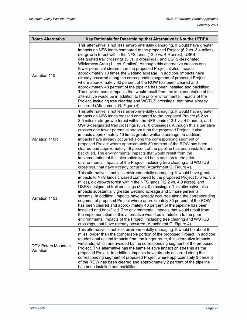
Mountain Valley Pipeline Project USACE Individual Permit Application
February 2021
Tetra Tech Page 27
Route Alternative Key Rationale for Determining that Alternative is Not the LEDPA
Variation 110
This alternative is not less environmentally damaging. It would have greater impacts on NFS lands compared to the proposed Project (6.2 vs. 3.4 miles), old-growth forest within the NFS lands (13.0 vs. 4.9 acres), USFS-designated trail crossings (3 vs. 0 crossings), and USFS-designated Wilderness Area (1.1 vs. 0 miles). Although this alternative crosses one fewer perennial stream than the proposed Project, it also impacts approximately 10 times the wetland acreage. In addition, impacts have already occurred along the corresponding segment of proposed Project where approximately 80 percent of the ROW has been cleared and approximately 48 percent of the pipeline has been installed and backfilled. The environmental impacts that would result from the implementation of this alternative would be in addition to the prior environmental impacts of the Project, including tree clearing and WOTUS crossings, that have already occurred (Attachment G; Figure 4).
Variation 110R
This alternative is not less environmentally damaging. It would have greater impacts on NFS lands crossed compared to the proposed Project (6.2 vs. 3.5 miles), old-growth forest within the NFS lands (12.1 vs. 4.9 acres), and USFS-designated trail crossings (3 vs. 0 crossings). Although this alternative crosses one fewer perennial stream than the proposed Project, it also impacts approximately 10 times greater wetland acreage. In addition, impacts have already occurred along the corresponding segment of proposed Project where approximately 80 percent of the ROW has been cleared and approximately 48 percent of the pipeline has been installed and backfilled. The environmental impacts that would result from the implementation of this alternative would be in addition to the prior environmental impacts of the Project, including tree clearing and WOTUS crossings, that have already occurred (Attachment G; Figure 4).
Variation 110J
This alternative is not less environmentally damaging. It would have greater impacts to NFS lands crossed compared to the proposed Project (5.3 vs. 3.5 miles), old-growth forest within the NFS lands (12.2 vs. 4.9 acres), and USFS-designated trail crossings (3 vs. 0 crossings). This alternative also impacts substantially greater wetland acreage and 5 more perennial streams. In addition, impacts have already occurred along the corresponding segment of proposed Project where approximately 80 percent of the ROW has been cleared and approximately 48 percent of the pipeline has been installed and backfilled. The environmental impacts that would result from the implementation of this alternative would be in addition to the prior environmental impacts of the Project, including tree clearing and WOTUS crossings, that have already occurred (Attachment G; Figure 4).
CGV Peters Mountain Variation
This alternative is not less environmentally damaging. It would be about 9 miles longer than the comparable portion of the proposed Project. In addition to additional upland impacts from the longer route, this alternative impacts wetlands, which are avoided by the corresponding segment of the proposed Project. This alternative has the same relative impact on streams as the proposed Project. In addition, impacts have already occurred along the corresponding segment of proposed Project where approximately 3 percent of the ROW has been cleared and approximately 2 percent of the pipeline has been installed and backfilled.

Mountain Valley Pipeline Project USACE Individual Permit Application
February 2021
Tetra Tech Page 28
Route Alternative Key Rationale for Determining that Alternative is Not the LEDPA
SR 635-ANST Variation
This alternative is not less environmentally damaging. In addition to greater upland impacts compared to the proposed Project (e.g., 4.9 acres vs. 0 acres old-growth forest), it would impact many more perennial streams (18 vs. 1 stream) and more wetland area (97 vs. 0 square feet). In addition, impacts have already occurred along the corresponding segment of the proposed Project where approximately 31 percent of the ROW has been cleared and approximately 19 percent of the pipeline has been installed and backfilled. The environmental impacts that would result from the implementation of this alternative would be in addition to the prior environmental impacts of the Project, including tree clearing and WOTUS crossings, that have already occurred (Attachment G; Figure 4).
AEP-ANST Variation
This alternative is not less environmentally damaging. In addition to greater upland impacts compared to the proposed Project (e.g., 2.6 vs. 1.7 miles in NFS lands), it would impact many more perennial streams (17 vs. 1 stream). Neither alternative impacts wetlands in this stretch. No impacts have occurred along the corresponding segment of proposed Project.
New River Conservancy Variation
This very small alternative is not less environmentally damaging. Neither the route variation nor the proposed Project in this area impact wetlands, although this variation impacts one fewer perennial stream. This alternative was determined to be more environmentally damaging than the proposed Project in this area because the proposed Project follows an existing powerline corridor, which allows it to avoid additional greenfield impacts to forests and agricultural lands that would result from the alternative. Further, this alternative would be about 0.4 mile longer and impact 7.1 more acres than the proposed Project. Of the 7.1 additional acres the alternative would impact, 6 acres are forested.
Canoe Cave Variation
The proposed Project through this section represents a route modification that was adopted by Mountain Valley to avoid potential impacts to Canoe Cave, which was identified as a hibernaculum for the threatened northern long-eared bat. The Canoe Cave Variation represented a second alternative route to avoid the cave, which is not less environmentally damaging. Neither route affects any streams or wetlands, and the proposed Project avoids impacts to interior forest (7.6 vs. 0 acres). In addition, impacts have already occurred along the corresponding segment of proposed Project where 100 percent of the ROW has been cleared. The environmental impacts that would result from the implementation of this alternative would be in addition to the prior environmental impacts of the Project, including tree clearing and WOTUS crossings, that have already occurred (Attachment G; Figure 4).
Brush Mt. Alternative 1
This alternative is neither practicable nor less environmentally damaging. This alternative would require constructing on a steeper slope than anywhere else on the proposed Project, which threatens worker safety and prevents equipment from traversing the ROW. Although this alternative would cross one fewer intermittent stream, it would cause significantly greater impacts to local residents because Brush Mountain Road would have to be closed for up to four weeks to complete construction in this area. Neither alternative impacts wetlands. In addition, impacts have already occurred along the corresponding segment of proposed Project where 100 percent of the ROW has been cleared. The environmental impacts that would result from the implementation of this alternative would be in addition to the prior environmental impacts of the Project, including tree clearing and WOTUS crossings, that have already occurred (Attachment G; Figure 4).

Mountain Valley Pipeline Project USACE Individual Permit Application
February 2021
Tetra Tech Page 29
Route Alternative Key Rationale for Determining that Alternative is Not the LEDPA
Brush Mt. Alternative 2
This alternative is not less environmentally damaging. Although this alternative would cross one fewer intermittent stream, it would cause significantly greater impacts to local residents because Brush Mountain Road would have to be closed for up to four weeks to complete construction in this area. Additionally, this alternative would require the pipeline to be installed in close proximity to a neighborhood (Preston Forest Subdivision), which Mountain Valley sought to avoid due to objections from homeowners. Neither alternative impacts wetlands. In addition, impacts have already occurred along the corresponding segment of the proposed Project where 100 percent of the ROW has been cleared and approximately 2 percent of the pipeline has been installed and backfilled. The environmental impacts that would result from the implementation of this alternative would be in addition to the prior environmental impacts of the Project, including tree clearing and WOTUS crossings, that have already occurred (Attachment G; Figure 4).
October 2015 Route Over the Mount Tabor Sinkhole Plain Variation
This alternative is neither practicable nor less environmentally damaging. This alternative was part of the originally proposed Project. However, field surveys indicated that the route crossed a large sinkhole plain, which would present geological hazards to the pipeline. The alternative is therefore impracticable. It is also not less environmentally damaging. The alternative crosses four fewer perennial streams, but it also crosses a wetland that is avoided by the proposed Project. Furthermore, the proposed Project avoids or reduces impacts to several sensitive sites, including the North Fork Historic District, Slussers Chapel Conservation Site, Old Mill Conservation Sites, and conservation easement areas administered by the Virginia Outdoors Foundation and The Nature Conservancy. In addition, impacts have already occurred along the corresponding segment of proposed Project where 100 percent of the ROW has been cleared and approximately 94 percent of the pipeline has been installed and backfilled. The environmental impacts that would result from the implementation of this alternative would be in addition to the prior environmental impacts of the Project, including tree clearing and WOTUS crossings, that have already occurred (Attachment G; Figure 4).
Slussers Chapel Conservation Site Variation
This alternative is not less environmentally damaging. Although this alternative would cross one fewer intermittent stream (and have the same area of wetland impact) than the proposed Project,38 it would impact a substantially greater area of NFS land (2.54 vs 0.04 miles) and interior forests (39.4 vs. 13.6 acres). Construction of this alternative also would impact USFS operations by requiring temporary closure of Forest Road 188. In addition, impacts have already occurred along the corresponding segment of proposed Project where 100 percent of the ROW has been cleared and approximately 60 percent of the pipeline has been installed and backfilled. The environmental impacts that would result from the implementation of this alternative would be in addition to the prior environmental impacts of the Project, including tree clearing and WOTUS crossings, that have already occurred (Attachment G; Figure 4).
38 In FERC FEIS § 3.5.1.11, table 3.5.1-11a, the alternative labeled “Variation 250” is the proposed Project route. The alternative in the table labeled “Proposed Route” was abandoned because it had a greater

Mountain Valley Pipeline Project USACE Individual Permit Application
February 2021
Tetra Tech Page 30
Route Alternative Key Rationale for Determining that Alternative is Not the LEDPA
Modified Variation 250
This alternative is not less environmentally damaging. Although it avoids one small wetland (44 square feet), this impact is more than offset by greater impacts on NFS lands (2.3 vs 0.04 miles) and interior forests (44.6 vs 13.6 acres). In addition, impacts have already occurred along the corresponding segment of proposed Project where 100 percent of the ROW has been cleared and approximately 69 percent of the pipeline has been installed and backfilled. The environmental impacts that would result from the implementation of this alternative would be in addition to the prior environmental impacts of the Project, including tree clearing and WOTUS crossings, that have already occurred (Attachment G; Figure 4).
Poor Mountain Variation
This alternative is not less environmentally damaging. Although this alternative would cross two fewer streams than the proposed Project (neither route impacts wetlands), the route had been adjusted in this location to avoid potential impacts to the Spring Hollow Reservoir—a public drinking water supply—and to avoid crossing through a public park (Roanoke Camp) owned by Roanoke County. Further, impacts have already occurred along the corresponding segment of proposed Project where approximately 22 percent of the ROW has been cleared and approximately 1 percent of the pipeline has been installed and backfilled. The environmental impacts that would result from the implementation of this alternative would be in addition to the many environmental impacts of the Project, including tree clearing and WOTUS crossings, that have already occurred (Attachment G; Figure 4).
Alternative 682
This alternative is not practicable due to constructability issues. This route traverses approximately 10,600 feet of extreme side-slope terrain and severe rock outcroppings, with slopes up to 70 to 90 percent grade. Further, impacts have already occurred along the corresponding segment of proposed Project where approximately 16 percent of the ROW has been cleared and approximately 1 percent of the pipeline has been installed and backfilled. The environmental impacts that would result from the implementation of this alternative would be in addition to the prior environmental impacts of the Project, including tree clearing and WOTUS crossings, that have already occurred (Attachment G; Figure 4).
October 2015 Blue Ridge Parkway (BRP) Variation
This alternative is not less environmentally damaging. Neither route impacts streams or wetlands in this segment, and the alternative has a greater visual impact on the BRP. Further, the pipeline has already been installed underneath the BRP along the proposed Project. Likewise, impacts have already occurred along the corresponding segment of proposed Project where approximately 89 percent of the ROW has been cleared and approximately 86 percent of the pipeline has been installed and backfilled. The environmental impacts that would result from the implementation of this alternative would be in addition to the prior environmental impacts of the Project, including tree clearing and WOTUS crossings, that have already occurred (Attachment G; Figure 4).
impact on the Slussers Chapel Conservation Site. The former route also had six more stream impacts (and the same wetland impacts).

Mountain Valley Pipeline Project USACE Individual Permit Application
February 2021
Tetra Tech Page 31
Route Alternative Key Rationale for Determining that Alternative is Not the LEDPA
Blue Ridge Parkway Alternative 1
This alternative is not less environmentally damaging. Neither route impacts streams or wetlands in this segment, and the alternative has a greater visual impact on the BRP. Further, the pipeline has already been installed underneath the BRP along the proposed Project. Likewise, impacts have already occurred along the corresponding segment of the proposed Project where approximately 89 percent of the ROW has been cleared and approximately 86 percent of the pipeline has been installed and backfilled. The environmental impacts that would result from the implementation of this alternative would be in addition to the many environmental impacts of the Project, including tree clearing and WOTUS crossings, that have already occurred (Attachment G; Figure 4).
Blue Ridge Parkway Alternative 2
This alternative is not less environmentally damaging. Neither route impacts streams or wetlands in this segment, and the alternative has a greater visual impact on the BRP. Further, the pipeline has already been installed underneath the BRP along the proposed Project. Likewise, impacts have already occurred along the corresponding segment of the proposed Project where approximately 89 percent of the ROW has been cleared and approximately 89 percent of the pipeline has been installed and backfilled. The environmental impacts that would result from the implementation of this alternative would be in addition to the prior environmental impacts of the Project, including tree clearing and WOTUS crossings, that have already occurred (Attachment G; Figure 4).
October 2015 Blackwater River Variation
This alternative is not less environmentally damaging. Although the alternative impacts one fewer perennial stream, this is offset by the fact that the proposed Project avoids all wetland impacts in this segment. Furthermore, the alternative includes two crossings of the Blackwater River in close proximity to a drinking water supply intake. The proposed Project was developed to avoid those crossings. Further, impacts have already occurred along the entire corresponding segment of the proposed Project where the ROW has been cleared and 100 percent of the pipeline has been installed and backfilled. The environmental impacts that would result from the implementation of this alternative would be in addition to the prior environmental impacts of the Project, including tree clearing and WOTUS crossings, that have already occurred (Attachment G; Figure 4).

Mountain Valley Pipeline Project USACE Individual Permit Application
February 2021
Tetra Tech Page 32
Route Alternative Key Rationale for Determining that Alternative is Not the LEDPA
Variation 35
This alternative is not less environmentally damaging. Although the alternative impacts four fewer small wetlands and two streams, those impacts are outweighed by other significant environmental effects. First, the alternative would require construction parallel to a stream for a “large segment of the route variation,”39 which likely would cause greater instream impact than a perpendicular crossing. Second, three archeological sites were identified in the alternative route, compared to zero for the proposed route. Third, the alternative has one open-water (pond) impact that is avoided by the proposed Project route. Further, impacts have already occurred along the entire corresponding segment of proposed Project route where the 100 percent of the ROW has been cleared and 100 percent of the pipeline has been installed and backfilled. The environmental impacts that would result from the implementation of this alternative would be in addition to the prior environmental impacts of the Project, including tree clearing and WOTUS crossings, that have already occurred (Attachment G; Figure 4).
39 FEIS § 3.5.1.15.

Mountain Valley Pipeline Project USACE Individual Permit Application
February 2021
Tetra Tech Page 33
AFFECTED ENVIRONMENT AND ENVIRONMENTAL REVIEW FACTORS
The beneficial and adverse environmental effects of the Project are fully described in various documents, including the 2017 FERC FEIS, 2020 BiOp, and the permitting records previously compiled by the respective USACE districts for the Nationwide Permit 12 verification actions. The changes to the Project proposed in this application are minimal, consisting primarily of modifying some of the proposed stream and wetland crossing from open cut to trenchless methods to further avoid and minimize direct aquatic impacts. The majority of aquatic impacts associated with the Project from crossings, ATWS, access roads, and upland construction in this application are identical to those previously considered by FERC, USACE, WV DEP, and VA DEQ. Furthermore, the concept of trenchless crossings has previously been evaluated, as Mountain Valley proposed to use trenchless crossing methods for a handful of crossings in both Virginia and West Virginia in the original Project configuration, several subsequent revisions approved by FERC, and the PCNs submitted to the Huntington and Pittsburgh Districts in 2020. To date, Mountain Valley has completed 73 trenchless crossings on the Project successfully and without incident. Sixty-seven (67) resources were crossed with a conventional bore; four were crossed with an HDD; and two were crossed with Direct Pipe).
To avoid duplicating efforts for elements of the Project that have not changed, Mountain Valley incorporates by reference the previous reviews of the Project’s environmental effects (namely, FEIS § 4.0). This section supplements and updates the relevant information from previous environmental reviews as necessary to ensure the USACE, WV DEP, and VA DEQ have the information they need to complete their reviews. Furthermore, this section addresses the technical evaluation factors in the 404(b)(1) Guidelines (40 C.F.R. Part 230, Subparts C, D, E, F, and H) and the Public-Interest Review factors (33 C.F.R. § 320.4(a)).
Proposed Aquatic Impacts
4.1.1 Jurisdictional Impacts
Tables 2, 3, and 4 identify the location and size of anticipated individual and cumulative wetland and stream impacts. Figure 4 shows the location and extent of wetland and stream impacts identified at the Project crossings included in this permit application.
For wetlands and streams crossed by the pipeline, a 10-foot depth of fill was used for temporary fill volume calculations. The 10-foot depth of fill includes the 42-inch-diameter pipe, padding, and backfill. For anticipated temporary palustrine emergent (PEM) wetland impacts and conversion impacts to palustrine forested (PFO) and palustrine scrub-shrub (PSS) wetlands not crossed by the pipeline, a 3-foot depth of fill was used for temporary fill volume calculations to account for the placement of timber mats in these wetlands during construction activity.. In Table 3, PFO and PSS wetland conversion with temporary fill impacts are identified separately from PEM wetlands with temporary fill impacts and from all wetlands with permanent fill impacts. For anticipated permanent fill impacts to wetlands along permanent access roads, a 3-foot depth of fill was used for permanent fill volume calculations. For anticipated permanent impacts to streams along permanent access roads, depth of fill for permanent fill volume calculations was equal to the culvert diameter plus 0.5 feet.
Plan and profile views for each proposed jurisdictional impact are found in Attachment H.
4.1.2 Section 10 Waters
As shown in Table 1 and Table 15, the Project crosses five waterbodies that have been determined to be, or are assumed to be, traditionally navigable waters under Section 10 of the Rivers and Harbors Act (33 U.S.C. § 403). Plan and profile views for each Section 10 crossing are found in Attachment H. Temporary impacts to each Section 10 traditionally navigable waters crossed by the Project would be avoided by proposed bore crossings, with the exception of the Blackwater River (S-F11; Table 1).

Mountain Valley Pipeline Project USACE Individual Permit Application
February 2021
Tetra Tech Page 34
Elk River (S-E68) (Webster County, West Virginia)
Mountain Valley previously proposed to cross the Elk River using the open-cut method. Mountain Valley proposes to cross this river using a guided conventional bore method, thereby avoiding all instream impacts. The pipeline will be installed at a minimum depth of six feet below the streambed to avoid any impact to the navigability of the river. Mountain Valley submitted a request to FERC in October 2020 to modify the crossing method for this river.
Gauley River (S-J29) (Nicholas County, West Virginia)
Mountain Valley previously proposed to cross the Gauley River using the open-cut method. On May 18, 2020, FERC authorized Mountain Valley to cross the Gauley River using the microtunnel method (FERC Accession No. 20200518-3008), which is consistent with the crossing method identified in the 2020 BiOp. With this application, Mountain Valley seeks permit authorization from the USACE to cross this river via the microtunnel method, thereby avoiding all instream impacts. The pipeline will be installed at a minimum depth of 12 feet below the streambed to avoid any impact to the navigability of the river.
Greenbrier River (S-I8) (Summers County, West Virginia)
Mountain Valley previously proposed to cross the Greenbrier River using the open-cut method. Mountain Valley proposes to cross this river using the Direct Pipe method, thereby avoiding all instream impacts. The pipeline will be installed at a minimum depth of 13 feet below the streambed to avoid any impact to the navigability of the river. Mountain Valley submitted a request to the FERC in October 2020 to modify the crossing method for this river.
Roanoke River (S-NN16) (Montgomery County, Virginia)
Mountain Valley originally proposed to cross the Roanoke River using the open-cut method. On October 9, 2020, FERC authorized Mountain Valley to cross the Roanoke River using the microtunnel method (1734 FERC ¶ 61,027), which is consistent with the crossing method identified in the 2020 BiOp. With this application, Mountain Valley seeks permit authorization from the USACE (and VMRC) to cross this river via the microtunnel method, thereby avoiding all instream impacts. The pipeline will be installed at a minimum depth of six feet below the streambed to avoid any impact to the navigability of the river.
Blackwater River (S-F11) (Franklin County, Virginia)
At the Blackwater River, Mountain Valley will minimize impacts by reducing the LOD width, avoiding placement of workspaces in sensitive habitats, revegetation, and backfilling and grading, and use of the previously approved dry-ditch open-cut crossing method (Section 5.1.1.1.2), which is consistent with the crossing method identified in the 2020 BiOp. The pipeline will be installed at a minimum depth of six feet below the streambed. Impacts to the Blackwater River will be temporary during construction, and the stream bed and banks will be restored as close as practicable to pre-construction contours. As a result, Mountain Valley does not anticipate that Project impacts to the Blackwater River (S-F11) will result in any permanent alteration of the river.
4.1.3 Wetland Delineation and Stream Identification
Wetland delineation and stream identification surveys were performed for Project areas at the crossings included in this permit application. Wetlands were delineated using the procedures identified in the USACE 1987 Wetland Delineation Manual (Environmental Laboratory, 1987) and the Regional Supplement to the Corps of Engineers Wetland Delineation Manual: Eastern Mountains and Piedmont Region (USACE, 2012) for making preliminary jurisdictional wetland determinations. Physical and biological characteristics of streams identified in the field were evaluated to determine flow regime (USACE NWPs Section F – Definitions, 2017), USACE Water Type (USACE, 2007), and Cowardin classification (Cowardin et al., 1979). Physical characteristics evaluated included but were not limited to channel morphology, substrate size/type, and base flow conditions. Biological characteristics evaluated included but were not limited to the presence of fish, aquatic macroinvertebrates, and vegetation rooted within the ordinary high-water mark. Figure 4 shows the location and extent of wetlands and streams identified within the Project LOD at the crossings included in this permit application. Preliminary Jurisdictional Determinations issued by the

Mountain Valley Pipeline Project USACE Individual Permit Application
February 2021
Tetra Tech Page 35
USACE, data forms, and photographs for wetlands and streams identified within the Project LOD at the crossings included in this permit application are provided in Attachment I.
4.1.4 Water Withdrawals
Mountain Valley anticipates withdrawing water from some streams in the West Virginia portion of Project area, including the Elk, Gauley, and Greenbrier rivers. The withdrawals will be used for borings, hydroseeding, dust suppression, and hydrostatic pressure testing. A permanent intake structure is not proposed for any water withdrawals. For water withdrawals in West Virginia, Mountain Valley will coordinate with the West Virginia DEP Division of Water and Waste (DWWM) and West Virginia Department of Natural Resources (WV DNR) to ensure water withdrawals comply with the DWWM guidance tool and WV DNR time-of-year restrictions (TOYR) or other instream restrictions. Also note that Mountain Valley has committed to not using water withdrawn from the Gauley River during the boring of the Gauley River, which is reflected in the 2020 BiOp. In Virginia, no surface-water withdrawals are proposed for Project use; Mountain Valley will obtain all water for borings, hydroseeding, dust suppression, and hydrostatic pressure testing from municipal water sources.
Sensitive Stream Resources
4.2.1 National Wild and Scenic Rivers
No stream crossings included in this permit application are National Wild and Scenic Rivers or rivers officially designated by Congress as a “study river” under the National Wild and Scenic Rivers Act.
4.2.2 WV Natural Streams Preservation Act
The segment of the Greenbrier River to be crossed by the Project in the USACE Huntington District is designated as a “protected stream” by the West Virginia Natural Streams Preservation Act (NSPA). The NSPA protects specified waters from impoundments, diversions, and flooding. Mountain Valley is proposing to cross the Greenbrier River using Direct Pipe drilling as shown on the boring plan and profile provided in Attachment H. Using this crossing method, no temporary or permanent instream impacts are anticipated and the provisions of the NSPA should not apply.
4.2.3 Tier 3 Protection
No Tier 3 Protected Waters are crossed by the Project in Virginia or West Virginia.
4.2.4 Trout Waters
In West Virginia, Category B-2 Trout Waters were identified in the Project area, and unavoidable temporary fills in these resources will occur during construction (Table 2). Mountain Valley will implement the erosion and erosion control devices (ECDs) identified in the approved ESCP to limit offsite soil migration and sedimentation. Mountain Valley has coordinated with the WV DNR, and stream waivers required for Project activities in 2021 will be submitted to WV DNR if the construction schedule warrants instream activities during the restriction period identified by WV DNR40.
In Virginia, DEQ Class V (Stockable trout waters) and Class VI (Natural trout waters) were identified in the Project area, and unavoidable temporary fills in these resources will occur during construction (Table 2). Mountain Valley will implement the ECDs identified in the DEQ-approved ESCP to limit offsite soil migration and sedimentation. Mountain Valley has coordinated with the VA Department of Wildlife Resources
40 See Public Notice No. LRH-2016-00006-WV [MOD] issued on January 24, 2020, available at:
https://www.lrh.usace.army.mil/Portals/38/docs/regulatory/nationwide/WV_NWP_2017_LRH_PN_WV-WQCmod.pdf, for recommended TOYRs (last visited 2/18/2021).

Mountain Valley Pipeline Project USACE Individual Permit Application
February 2021
Tetra Tech Page 36
(VDWR) and will adhere to VDWR recommended TOYRs41 for crossings of designated trout streams. However, Mountain Valley will request waivers from the relevant resource agencies if the construction schedule warrants instream activities during the restriction period.
4.2.5 Warm Water Fishery
Warm Water Fishery waters were identified in the West Virginia portion of the Project area. Mountain Valley will implement the ECDs identified in the approved ESCPs to limit offsite soil migration and sedimentation. Unavoidable temporary fills in these resources will occur during construction (Table 2). Mountain Valley has coordinated with the WV DNR, and stream waivers required for Project activities in 2021 will be submitted to WV DNR if the construction schedule warrants instream activities during the restriction period42.
4.2.6 Anadromous Fish Use Areas
The Project does not cross any Anadromous Fish Use Areas.
4.2.7 Aquatic Life Movements
Project activities will not substantially disrupt the necessary life cycle movements of aquatic life indigenous to the waterbodies in the Project area. Permanent and temporary crossings of waterbodies will be suitably culverted, bridged, or otherwise designed and constructed to be countersunk as appropriate, and to maintain low flows to sustain the movement of aquatic species. During the open-cut stream installation process, stream-flow connectivity will be maintained between the upstream and downstream segments of the crossing through flumes and/or water pumps. The crossings will also be installed as a continuous process, thereby reducing the overall time to complete the installation. Culverts were sized using either (1) the Rational Formula for a 24-hr 10-year storm and Manning’s Equation, or (2) according to the Culvert Sizing Chart from the 2006 WV DEP’s Erosion and Sediment Control Best Management Practice (BMP) Manual (2006, updated 2016). In Virginia, culverts will conform to the standard in Norfolk District 2017 NWP Regional Condition 8 to countersink all pipes and culverts below the bed of the stream. Culvert sizing shall be in accordance with the Project’s DEQ approved Annual Standards and Specifications which incorporate Virginia Erosion and Sediment Control Handbook (VESCH), Third Edition, 1992, Standard and Specification 3.24. As such, culverted crossings will be sized and installed in a manner to allow the passage of aquatic life and freely pass bankfull flows.
4.2.8 Spawning Areas
Activities in spawning areas during spawning seasons will be avoided to the maximum extent practicable. Mountain Valley has continued to coordinate with USFWS, WV DNR, and VDWR regarding sensitive stream resources and recommended TOYRs for stream crossings.
4.2.9 Submerged Aquatic Vegetation
The Project does not cross any Submerged Aquatic Vegetation areas.
41 See VDWR Time of Year Restrictions and Other Guidance, available at:
https://dwr.virginia.gov/wp-content/uploads/media/Time-of-Year-Restrictions.pdf, for recommended TOYRs (last visited 2/18/2021).
42 See Public Notice No. LRH-2016-00006-WV [MOD] issued on January 24, 2020 for recommended TOYRs.

Mountain Valley Pipeline Project USACE Individual Permit Application
February 2021
Tetra Tech Page 37
4.2.10 Freshwater Mussels
Mussel surveys were conducted for the Project in coordination with USFWS, WV DNR, and VDWR. No federally listed species were encountered during any mussel survey or salvage efforts along the Project route in West Virginia or Virginia.
In West Virginia and Virginia, non-listed freshwater mussels were identified in streams along the Project route and, in Virginia, state-listed freshwater mussels were identified along the Project route (Table 2). Mountain Valley has continued to coordinate with USFWS, WV DNR, and VDWR and will adhere to recommended TOYRs and mussel relocations, as required, for crossings of streams with freshwater mussels. Refer to FEIS §§ 2.4.2.10 and 4.6.2.7 for additional information.
4.2.11 Designated Critical Resource Waters
No Designated Critical Resource Waters, including the Chesapeake Bay National Estuarine Research Reserve, occur in the Project area.
404(b)(1) Guidelines Technical Evaluation Factors The following summarizes information relevant to the 404(b)(1) Guidelines’ Technical Evaluation Factors (40 C.F.R. Part 230, Subparts C, D, E, F, and H).
4.3.1 Substrate (§ 230.20)
Prior to installing a crossing, the top one foot of a streambed substrate or wetland soil (where hydrologic conditions allow) will be segregated and stockpiled separately from subsoils. Following installation of the pipe in a stream, the substrate will be replaced last to restore the streambed’s armoring layer, and the surface will be returned as close as practicable to preconstruction contours. Following installation of the pipe in a wetland, the wetland topsoil will be restored, de-compacted, and returned as close as practicable to preconstruction contours. Refer to Sections 5.2.8 and 5.2.9 for additional details.
4.3.2 Suspended Particles/Turbidity (§ 230.21)
Mountain Valley will use the dry-ditch open-cut method to install the pipeline in streams included in this application, except for the Section 10 Rivers previously discussed. This method involves the use of cofferdams, flumes, pumps, or other measures to dewater the construction site and divert flow around the site for the duration of the crossing. Erosion and sediment control measures are implemented during this activity in accordance with the FERC Wetland and Waterbody Construction and Mitigation Procedures (Wetland and Waterbody Procedures; FERC, 2013b) and ESCPs approved by the WV DEP and VA DEQ. These measures reduce the potential for suspended particle and turbidity impacts during construction and immediately after flow is restored to the site. Refer to Sections 5.2.1 and the Construction Details (Attachment J) for additional details. FERC’s evaluation of the minor temporary sediment and turbidity impacts of this crossing method can be found at FEIS §§ 4.3.2.1 and 4.13.2.1 (refer specifically to pages 4-120 and 4-604).
The installation of culverts will cause a similarly minimal and short-term increase in suspended particle and turbidity in streams with flowing water.
4.3.3 Water (§ 230.22)
Due to the dry-ditch open-cut construction practices discussed in Section 4.3.2, impacts to water quality will include minimal, short-term increases in sediment loads and turbidity level. The discharges would not be expected to materially affect water odor, taste, biochemical oxygen demand, dissolved oxygen, or nutrient loads.

Mountain Valley Pipeline Project USACE Individual Permit Application
February 2021
Tetra Tech Page 38
4.3.4 Current Patterns and Water Circulation (§ 230.23)
Water current patterns and circulation will be temporarily affected only during the period of active construction within a waterbody for an open-cut. As noted above, water flow will be maintained by using diversions, flumes, and/or pumps to divert flow around the work site. To minimize the duration of such disturbances, stream crossings are completed on consecutive days until the crossing is complete and the stream is restored. Following pipe installation, the stream is restored as close as practical to its preconstruction contours to avoid any changes to current patterns or water circulation.
As discussed in Section 4.2.7, culverts will be installed to maintain water flows and circulation patterns.
4.3.5 Normal Water Fluctuations (§ 230.24)
As discussed above, the Project’s stream impacts are primarily temporary before being restored as close as practicable to preconstruction contours. Additionally, Mountain Valley installs permanent trench breakers adjacent to all waterbody crossings so that the disturbed trench soil does not create a preferential pathway for subsurface flow that could alter stream hydrology. These measures should prevent any long-term changes to the normal water fluctuations of impacted streams.
As discussed in Section 4.2.7, culverts will be installed to maintain water flows and circulation patterns and therefore should have no effect on normal water fluctuations.
4.3.6 Salinity Gradients (§ 230.25)
Because the Project will not materially affect stream flows, there is no foreseeable possibility of downstream changes to salinity gradients.
4.3.7 Threatened and Endangered Species § (230.30)
Refer to Section 1.8.4 and the 2020 BiOp for additional information.
4.3.8 Fish, Crustaceans, Mollusks, and Other Aquatic Organisms in Food Web (§ 230.31)
Literature reviewed by the USFWS reflect that impacts on fish and benthic invertebrates resulting from dry-ditch open-cut crossings were temporary and limited to several hundred meters downstream. (Biological Opinion 102). As discussed above, the Project employs mitigation measures to minimize the sediment and turbidity impacts from stream crossings. Mountain Valley completes fish and mussel relocations and adheres to TOYRs when required by relevant federal or state authorities. Refer to FEIS §§ 4.6.2.7 and 2.4.2.10 for additional information on fish and mussel relocation measures and FEIS § 4.6.1.1, Table 4.6.1-2 for TOYRs.
4.3.9 Other Wildlife (§ 230.32)
Mountain Valley is not aware of any adverse effects on other wildlife associated with aquatic ecosystems, including migratory bird breeding areas, resulting from the discharge of dredged or fill material during stream and wetland crossings.
4.3.10 Sanctuaries and Refuges (§ 230.40)
The Project does not affect any estuarine or marine sanctuaries or designated wildlife refuges. To the extent this factor applies to the Jefferson National Forest, the Project crosses a 3.5-mile section. The USFS determined that the Project’s effects on aquatic species in the Jefferson National Forest would “be minor, short-term and mostly limited to construction activities associated with construction” and impacts to terrestrial species would be “minor.” Refer to the USFS SEIS § 3.5.4.2 for additional information.

Mountain Valley Pipeline Project USACE Individual Permit Application
February 2021
Tetra Tech Page 39
4.3.11 Wetlands (§ 230.41)
The destruction and loss of wetlands has been avoided and minimized to the maximum extent practicable in accordance with the 404(b)(1) Guidelines. Notwithstanding the size of the Project, it has been carefully designed to cause minimal permanent loss of wetlands; only approximately 7% of wetland crossings would result in any permanent wetland loss, and no permanent wetland impact is greater than 0.06-acre.
4.3.12 Mud Flats (§ 230.42)
The Project does not affect any mud flats.
4.3.13 Vegetated Shallows (§ 230.43)
Mountain Valley is not aware of any impacts to vegetated shallows.
4.3.14 Riffle and Pool Complexes (§ 230.45)
As part of the stream restoration process, Mountain Valley will replace the stream substrate and restore the streambed as close as practicable to preexisting contours.
4.3.15 Municipal and Private Water Supplies (§ 230.50)
The Project crossing of the Greenbrier River is located within 0.3 mile of Rich Creek Spring in Monroe County, West Virginia. Rich Creek Spring is a privately owned spring that contributes water to Rich Creek, in which the Red Sulphur Public Service District (PSD) has a surface water intake that is located approximately 7.75 miles from Rich Creek Spring. Mountain Valley has worked with the PSD since 2016 to address concerns about its water sources and funded an independent, third-party consultant selected by the PSD to develop a contingency plan to protect the PSD water supplies and mitigate potential sediment impacts, if such occur. Mountain Valley proposes to cross the Greenbrier with the Direct Pipe crossing method. As described in Section 3.3.1.5, this Direct Pipe bore will result in a crossing with low potential for inadvertent return (IR), steerability through varying geology, minimal potential for collapse during the bore process, continuous drilling operation during installation, and the minimization of environmental impacts to the maximum amount practicable.
In Virginia, one public water supply has a surface water intake located within three miles downstream of a pipeline crossing: the Roanoke River intake for the Spring Hollow Reservoir (Roanoke County, Virginia). The Western Virginia Water Authority operates a surface water intake on the Roanoke River approximately 1.2 miles downstream of the crossing of the Roanoke River. Mountain Valley proposes to cross the Roanoke River with the microtunnel method. This bore crossing method limits the potential for an IR and minimizes environmental impacts to the maximum extent practicable.
Mountain Valley will continue to coordinate with the PSDs until the project is completed and stabilized. Mountain Valley’s Water Resources Identification and Testing Plan (revised February 2017) requires Mountain Valley to implement a plan to test the water quality of private wells in the vicinity of the Project and to mitigate any adverse effects. Since Mountain Valley commenced construction in the spring of 2018, there have been no documented adverse impacts to private water supplies in the vicinity of the Project.
4.3.16 Recreational and Commercial Fisheries (§ 230.51)
Other than making small stream segments temporarily unavailable during the period of active instream construction, Mountain Valley does not anticipate any material impacts on commercial and recreational fishing. (FEIS 4-223). Mountain Valley adheres to applicable TOYRs in trout waters in West Virginia and Virginia. If necessary, Mountain Valley will request TOYR waivers from the appropriate agency. See section 4.2.4 for additional information on TOYR waivers.

Mountain Valley Pipeline Project USACE Individual Permit Application
February 2021
Tetra Tech Page 40
4.3.17 Water-Related Recreation (§ 230.52)
Other than making small stream segments temporarily unavailable during active instream construction, Mountain Valley is not aware of any material impacts on water-related recreational activities.
4.3.18 Aesthetics (§ 230.53)
With the exception of minor permanent impacts associated with culvert repair and replacement, the permanent conversion of PFO and PSS wetland to PEM wetland habitat within the pipeline ROW, and the permanent fill of three small wetlands within the pipeline ROW, all aquatic impacts will be restored as close as practicable to preconstruction conditions. After the period of active construction and restoration, Mountain Valley does not foresee any effects on aesthetics associated with restored aquatic ecosystems. Refer to FEIS § 4.3.18 and 4.4.3 for additional information.
4.3.19 Parks, National and Historical Monuments, National Seashores, Wilderness Areas, Research Sites and Similar Preserves (§ 230.54)
The Project does not cross any National or Historical Monuments, Wilderness Areas, National Seashores, or research sites. The Project crosses two resources administered by the National Park Service—the Appalachian National Scenic Trail and the Blue Ridge Parkway. Mountain Valley has already bored under the BRP and will bore under the Appalachian Trail to avoid and minimize impacts. The project also crosses two sections of the Jefferson National Forest. Mountain Valley has only been authorized to boring the streams in this section of the project.
4.3.20 General Evaluation of Dredged or Fill Material (§§ 230.60, 230.61)
Mountain Valley is not aware of factors listed in 40 C.F.R. § 230.60(b) that would indicate that any potential dredge or fill material handled by Mountain Valley is a carrier of contaminants. If suspected contaminants are encountered, Mountain Valley would initiate the procedures outlined in the “Unanticipated Discovery of Contamination Plan” (as required by FERC) and coordinate with the appropriate state and federal agencies.
4.3.21 Actions concerning the location of the discharge (§ 230.70)
All discharges of fill material will be for the purpose of returning wetland soils and stream subsoil and substrates removed during construction to their original location and contours.
4.3.22 Actions concerning the material to be discharged (§ 230.71)
All discharges of fill material will be for the purpose of returning wetland soils and stream subsoil and substrates removed during construction to their original location and contours.
4.3.23 Actions controlling the material after discharge (§ 230.72)
As discussed in Section 4.3.1, Mountain Valley will use segregated stream substrates and upper 12 inches of the wetland to restore stream and wetland crossings. The purpose of this practice is to reduce erosion of the streambed after flow is restored and to restore hydric soils and wetland seed beds.
Mountain Valley does not expect excessive erosion or soil loss from restored wetlands.
4.3.24 Actions affecting the method of dispersion (§ 230.73)
The Project will not be dispersing any dredged material.

Mountain Valley Pipeline Project USACE Individual Permit Application
February 2021
Tetra Tech Page 41
4.3.25 Actions related to technology (§ 230.74)
Mountain Valley employs experienced construction crews and appropriate industry-standard construction equipment to complete stream and wetland crossings as required by the FERC’s Wetland and Waterbody Construction and Mitigation Procedures, VA DEQ Annual Standards and Specifications, and WV DEP Water Pollution Control Act Permit for Construction authorization Industry-standard construction practices include but are limited to using stream diversions to create dry working areas, operating from equipment mats, using low-ground pressure equipment, refueling at least 100-feet from streams and wetlands, training Mountain Valley workers on environmental protection requirements, and designing and installing erosion control devices to protect the adjacent resource.
As discussed in Section 5.1.1, Mountain Valley conducted a site-specific evaluation of available crossing method technologies to identify the method that would minimize the impact to the extent appropriate and practicable for each crossing.
Permanent and temporary crossings of waterbodies will be suitably culverted, bridged, or otherwise designed and constructed to be countersunk as appropriate and to maintain low flows to sustain the movement of aquatic species. As such, culverted crossings will be sized and installed in a manner to allow the passage of aquatic life and freely pass bankfull flows.
4.3.26 Actions affecting plant and animal populations (§ 230.74)
The Project minimizes impacts to aquatic habitat by restoring all temporary impacts as close as practicable to preconstruction conditions. The 2020 BiOp includes mitigation measures to minimize harm to threatened and endangered species. Mountain Valley adheres to all applicable TOYRs imposed by federal or state resource agencies for the protection of aquatic and terrestrial species.
4.3.27 Actions affecting human use (§ 230.76)
The Project’s impact on human use of streams and wetlands will be minimal and solely limited to the period of active instream and wetland construction. As noted in Section 4.3.13, dredged material will not be discharged in proximity to any public water supply intakes.
4.3.28 Other actions (§ 230.77)
The Project does not include any of the activities addressed in this evaluation factor.
Public-Interest Review Factors Pursuant to 33 C.F.R. § 320.4(a), the USACE must conduct a public-interest review that considers the “probable impacts . . . of the proposed activity and its intended use on the public interest.” This review must balance the “benefits which reasonably may be expected to accrue from the proposal . . . against its reasonably foreseeable detriments.” This section provides a summary of information relevant to each of the 21 public-interest review factors listed in § 320.4(a) and, where appropriate, the additional policies described in § 320.4(b) through (r).
4.4.1 Conservation (§ 320.4(a))
The Project will have a neutral (mitigated) effect on conservation.
Although the Project is large in scope, the vast majority of the pipeline and related facilities will be buried. The land surface will be restored and returned as close as practicable to preconstruction uses. The Project impacts therefore are predominantly temporary in nature.
The most significant long-term Project-related effect on conservation stems from the maintenance of the permanent ROW. In areas that were forested prior to construction, maintenance of the ROW will cause a loss to the environmental service benefits of forest cover and forest cores, as well as the aesthetic impacts of the same. To mitigate impacts to forests, Mountain Valley entered into a voluntary mitigation agreement

Mountain Valley Pipeline Project USACE Individual Permit Application
February 2021
Tetra Tech Page 42
with the Commonwealth of Virginia that included a $20 million contribution divided between the Virginia Outdoors Foundation and U.S. Endowment for Forestry and Communities. Those funds must be used for forest preservation and enhancement “within a reasonable proximity to, and within the same terrestrial ecoregion as, the location of forest impacts.” In addition, Mountain Valley is coordinating with the WV DNR to identify the appropriate mitigation to offset impacts to interior forests.
4.4.2 Economics (§ 320.4(a))
The project will have a significant beneficial effect on the local and regional economy.
According to Mountain Valley’s Project need assessment, the Project would alleviate some of the constraints on Appalachian Basin natural gas production by adding infrastructure to transport lower-priced natural gas to industrial users and power generators in the Mid-Atlantic and Southeastern United States, as well as to LDCs. Per Section 5.1.9 of the FERC FEIS (FERC, 2017), the Project would have short-term positive economic impacts on the affected counties due to hiring and wages and expenditures for commodities, including money spent at restaurants and hotels by workers. The long-term socioeconomic effect of the Project is likely to be beneficial due to the increase in tax revenues. Based on the analysis presented in Section 4.9 of the FERC FEIS (FERC, 2017), the Project would not have a significant adverse effect on the socioeconomic conditions of the Project area. As such, Mountain Valley anticipates that the Project crossings included in this permit application will have a significant positive effect on economics.
4.4.3 Aesthetics (§ 320.4(a))
The Project will have a neutral (mitigated) effect on aesthetics.
As discussed in Section 4.1.1, Mountain Valley will have a minimal and temporary detrimental effect on aesthetics in most areas of the Project during construction activities. After Project restoration, these effects will be eliminated in most areas as the ROW is restored as close as practicable to preconstruction conditions.
4.4.4 General Environmental Concerns (§ 320.4(a))
The Project will have a neutral (mitigated) effect on general environmental concerns.
The FEIS provides a comprehensive evaluation of all relevant environmental concerns associated with the Project. FERC concluded: “Construction and operation of the MVP . . . would result in limited adverse environmental impacts, with the exception of impacts on forested land. . . . As part of our review, we developed specific mitigation measures that we determined would appropriately and reasonably reduce the environmental impacts resulting from construction and operation of the projects.”43
4.4.5 Wetlands (§ 320.4(a) & (b))
The Project will have a neutral (mitigated) effect on wetlands.
The destruction and loss of wetlands has been avoided and minimized to the maximum extent practicable in accordance with the 404(b)(1) Guidelines. Notwithstanding the size of the Project, it has been carefully designed to cause minimal permanent loss of wetlands. Proposed impacts are summarized in Section 4.1.1. Compensatory mitigation will be provided for the permanent and conversion impacts as stated in Section 5.3 (Mitigation). Furthermore, in Section 4.3.3.5 of the FEIS, FERC concluded that impacts of the Project on wetlands would not be significant.
43 FERC FEIS § 5.1.

Mountain Valley Pipeline Project USACE Individual Permit Application
February 2021
Tetra Tech Page 43
4.4.6 Historic, Cultural, Scenic, and Recreational Values (§ 320.4(a) & (e))
The Project will have a neutral (mitigated) effect on historic, cultural, and recreational values.
FERC developed a Programmatic Agreement in consultation with the USACE, among others, to resolve adverse effects at affected historic and cultural properties in accordance with 36 C.F.R. § 800.14(b)(3). Based on the Project adherence to the tenets and conditions of the Programmatic Agreement between FERC; WV Department of Culture, Arts, and History, VA Department of Historic Resources; and other federal permitting agencies, Mountain Valley anticipates that the Project crossings included in this permit application will have an insignificant (mitigated) effect on historic and cultural values.
In Section 4.8.3 of the FEIS (FERC, 2017), FERC concluded that impacts of the Project on scenic and recreational values would be adequately minimized with the adherence to the measures committed to by Mountain Valley, FERC’s recommendations, and other agency permitting conditions. Based on the evaluation by FERC, Mountain Valley anticipates that the Project crossings included in this permit application will have an insignificant effect on scenic and recreational values.
The Project does not cross any federally designated Wild and Scenic Rivers, National Rivers, National Wilderness Areas, National Seashores, National Recreation Areas, National Lakeshores, National Monuments, or estuarine and marine sanctuaries. The Project crosses two resources administered by the National Park Service—the Appalachian National Scenic Trail and the Blue Ridge Parkway. Mountain Valley has bored under the BRP or will bore under the Appalachian Trail to avoid and minimize impacts and will implement various other mitigation measures developed in consultation with the relevant agencies and stakeholders.
Additional information on recreational and special interest areas crossed by or in the vicinity of the Project can be found in FEIS § 4.8.1.6.
4.4.7 Fish and Wildlife Values (§ 320.4(a) & (c))
The Project will have a neutral (mitigated) effect on fish and wildlife values.
Mountain Valley initiated consultation with USFWS, WV DNR, VDWR, and the VA Department of Conservation and Recreation in October 2014 regarding records of known federally listed, state-listed, or rare species within the Project area. In coordination with these agencies, qualified biologists conducted surveys for potential rare, threatened, and endangered species within the Project area starting in 2015 and continuing through 2020.
On September 4, 2020, the USFWS provided FERC with a non-jeopardy biological opinion (BiOp) based on USFWS’s review of the Project and its effects on five federally listed species within the Project area. The 2020 BiOp determined that the Project is not likely to jeopardize the continued existence of Virginia spiraea (Spiraea virginiana), Roanoke logperch (Percina rex), candy darter (Etheostoma osburni), Indiana bat (Myotis sodalis), or northern long-eared bat (Myotis septentrionalis). Numerous monitoring and mitigation measures are included in the 2020 BiOp and other relevant agency documents to protect sensitive species.
In Section 4.5.3 of the FEIS, FERC concluded that impacts of the Project on wildlife would not be significant. In Section 4.6.2.8 of the FEIS, FERC concluded that impacts of the Project on fisheries and aquatic resources would not be significant. Based on the evaluations of USFWS and FERC, Mountain Valley anticipates that the Project crossings included in this permit application will have an insignificant effect on fish and wildlife, including migratory bird breeding areas.
4.4.8 Floodplain Hazards, Values, and Management (§ 320.4(a) & (l))
The Project will have no effect on floodplain hazards, values, and management.
As shown on the Section 10 River Crossing Plans (Attachment H) and the approved ESCPs, the Project crossings included in this permit application will not result in the permanent alteration of Federal Emergency Management Agency (FEMA)-delineated 100-year floodplains. In addition, Mountain Valley has received

Mountain Valley Pipeline Project USACE Individual Permit Application
February 2021
Tetra Tech Page 44
approvals from county floodplain managers for work in applicable areas. As such, Mountain Valley anticipates that the Project crossings included in this permit application will have no material effect on FEMA-delineated 100-year floodplains.
4.4.9 Land Use (§ 320.4(a))
The Project will have a minor detrimental effect on land use.
As discussed above, the vast majority of the pipeline and related facilities will be buried. The land surface will be restored and returned as close as practicable to preconstruction uses. Landowners subject to the ROW will be restricted from planting trees or building structures on the ROW but otherwise may resume any preconstruction activities on the land. Refer to FEIS § 4.8.2.1 for additional information.
4.4.10 Navigation (§ 320.4(a) & (o))
The Project will have no material effect on navigation.
Mountain Valley is proposing that the Section 10 waters crossings of the Elk River, Gauley River, Greenbrier River, and Roanoke River will be completed using microtunneling or Direct Pipe drilling (Table 1).44 Mountain Valley is proposing that the Section 10 waters crossing of the Blackwater River will be completed using a dry-ditch open cut crossing completed using a dam and pump method. Neither temporary nor permanent instream impacts to these Section 10 Rivers are anticipated.
4.4.11 Shore Erosion and Accretion (§ 320.4(a))
The Project will have no material effect on shore erosion and accretion.
4.4.12 Water Supply and Conservation (§ 320.4(a) & (m))
The Project will have a negligible effect on water supply and conservation.
The Project crossings included in this permit application will not involve the permanent alteration of streambeds or the placement of any permanent structure or within a WOTUS that will impede or alter stream flow. The pipe will be below grade and will not impede or alter stream flow. Upon completion of stream crossing activities, cleanup and restoration activities will commence as soon as practicable to replace grade cuts as close as practicable to preconstruction contours, restore streambank ground cover, minimize erosion, and stabilize stream banks for their natural reversion toward their previous state.
In the Water Resources Identification and Testing Plan (revised February 2017) filed with the FERC45, Mountain Valley identified and evaluated public water supplies with an intake located within three miles downstream of the proposed alignment waterbody crossing, and/or where the Project is located within 0.5 mile of a Zone of Critical Concern defined by the West Virginia Department of Health and Human Services for regulating aboveground storage tanks.
The Project crossing of the Greenbrier River is located within 0.3 mile of Rich Creek Spring in Monroe County, West Virginia. Rich Creek Spring is a privately owned spring that contributes water to Rich Creek, in which the Red Sulphur PSD has a surface water intake that is located approximately 7.75 miles from Rich Creek Spring. Mountain Valley has worked with the PSD since 2016 to address concerns about their water sources and funded an independent, third-party consultant selected by the PSD to develop a
44 The pipeline was successfully installed under the Pigg River with a horizontal directional drill.
45 Accession number 20170209-5249

Mountain Valley Pipeline Project USACE Individual Permit Application
February 2021
Tetra Tech Page 45
contingency plan to protect the PSD water supplies and mitigate potential sediment impacts, if such occurs. Mountain Valley proposes to cross the Greenbrier with the Direct Pipe crossing method. As described in Section 3.3.1.5, this Direct Pipe bore will result in a crossing with low potential for IR steerability through varying geology, minimal potential for collapse during the bore process, continuous drilling operation during installation, and the minimization of environmental impacts to the maximum amount practicable.
In Virginia, one public water supply has a surface water intake located within three miles downstream of a pipeline crossing: the Roanoke River intake for the Spring Hollow Reservoir (Roanoke County, Virginia). The Western Virginia Water Authority operates a surface water intake on the Roanoke River approximately 1.2 miles downstream of the crossing of the Roanoke River. Mountain Valley proposes to cross the Roanoke River with the microtunnel method. This bore crossing method limits the potential for an IR and minimizes environmental impacts to the maximum extent practicable.
The Water Resources Identification and Testing Plan (revised February 2017) also required Mountain Valley to implement a plan to test the water quality of private wells in the vicinity of the Project and to mitigate any adverse effects. Since Project construction commenced in spring 2018, there have been no documented adverse impacts to private water supplies.
The Project uses relatively modest quantities of water for dust suppression, hydrostatic testing, boring, and other construction activities. Project water use is not expected to have any appreciable effect on local water supplies. There will be no surface water withdrawals in Virginia. In West Virginia water withdrawals will be conducted in compliance with conditions of the WV DEP Division of Water and Waste Management’s Water Withdrawal Guidance tool. Mountain Valley will refrain from withdrawing water during low flows and during drought conditions by adhering to the restrictions identified in the WV DEP Division of Water and Waste Management’s Water Withdrawal Guidance tool.
4.4.13 Water Quality (§ 320.4(a) & (d))
The Project will have a minor and temporary adverse effect on water quality.
Upland Construction Stormwater. Potential short-term adverse water quality impacts from upland construction activities (including bore pits associated with trenchless crossings) will be minimized by compliance with the ESCPs issued and/or approved by the WV DEP and VA DEQ. Refer to Section 5.2.4 for additional detail. Mountain Valley has engaged in a comprehensive modeling effort, using the best available science, to produce a conservative estimate of the total sediment loads from Project construction. Mountain Valley’s Hydrologic Analysis (Geosyntec 2020) concluded that Project construction will result in minor marginal and localized increases in instream sediment loads and turbidity levels. The sediment and turbidity increases begin to trend down as soon as the ROW enters the restoration phase, nearing preconstruction levels within one year of the completion of construction. Because the ROW areas cannot be fully restored until construction is complete in those locations, and construction cannot be completed until the stream and wetland crossings are re-authorized, expeditious approval of this application weighs heavily in the public interest.
Post-Construction Stormwater. The Project must implement post-construction stormwater management measures in accordance with requirements from the FERC (Upland Erosion Control, Revegetation, and Maintenance Plan). Compliance with these requirements and applicable state requirements ensures that post-construction stormwater runoff from the Project area will not cause downslope or downstream erosion or other adverse water quality impacts.
In-Stream Construction. Potential water quality impacts associated with instream construction will be minimized through the use of dry-ditch open-cut crossing techniques in conjunction with erosion and sediment control measures required by FERC, FERC, WV DEP, and VA DEQ. Refer to Section 5.2.1 for additional detail. FERC evaluated dry-ditch open-cut crossing methods in the FEIS, stating:
A study conducted by the [U.S. Geological Survey] (Moyer and Hyer, 2009) investigating the effects of dry open-cut waterbody crossings on downstream sediment loading found that short-term increases in turbidity downstream of construction did occur, but the magnitude of the increase was small and considered to be minimal compared to increased

Mountain Valley Pipeline Project USACE Individual Permit Application
February 2021
Tetra Tech Page 46
turbidity associated with natural runoff events. Other literature (e.g., Reid et. al., 2004) assessing the magnitude and timing of suspended sediment produced from open-cut dry crossing methods indicates the duration of increased sedimentation would be mostly short-term (i.e., less than 1-4 days) and remain near the crossing location (i.e., an approximate downstream distance of a few hundred feet). (FEIS 4-120).
Hydrostatic Test Water Discharges. In accordance with FERC and state discharge permit requirements, hydrostatic test water would be discharged through sediment filters in vegetated upland areas.
4.4.14 Energy Needs, Energy Conservation and Development (§ 320.4(a) & (n))
The Project will have a major beneficial effect on energy needs and development.46
As described in the FERC FEIS, the Project will provide for transportation of abundant Appalachian Basin natural gas supplies to Transco Station 165, where this natural gas can serve the growing demand for natural gas use by LDCs, industrial users, and power-generation facilities along the Eastern seaboard. The Project will also provide gas to four intermediate delivery points: the WB Interconnect in Braxton County, West Virginia; Greene Interconnect in Monroe County, West Virginia; Roanoke Gas Lafayette Tap in Montgomery County, Virginia; the Roanoke Gas Franklin Tap in Franklin County, Virginia.
4.4.15 Safety (§ 320.4(a))
The Project will have no material effect on safety.
Pipeline maintenance and operation is a highly regulated activity. The Project will comply with all applicable PHMSA requirements to ensure the safe operation of the pipeline. Refer to FEIS § 4.12 for additional information.
4.4.16 Food and Fiber Production (§ 320.4(a))
The Project will have a negligible effect on food and fiber production.
The Project crosses a number of parcels in active agricultural use. The landowners’ use of those parcels may be affected temporarily during Project construction. After the completion of construction, these areas may return to their preconstruction agricultural uses. Because the temporary impacts on agricultural uses have been prolonged by delays in Project completion, consideration of this factor weighs in favor of expeditious approval of this application.
4.4.17 Mineral Needs (§ 320.4(a))
The Project will have no effect on mineral needs.
4.4.18 Consideration of Property Ownership (§ 320.4(a) & (g))
The Project will have a neutral (mitigated) effect on property ownership.
Natural gas companies must obtain easements from landowners along the route of their pipelines to construct and operate authorized facilities. Easements can be temporary, which grant the company the use of the land during construction (e.g., extra workspaces, temporary access roads, yards), or permanent, which grant the company the right to operate and maintain the facilities once constructed. The majority of landowners along the ROW were willing sellers. A number of easements had to be procured through
46 The USACE’s regulations state: “Energy conservation and development are major national objectives. District engineers will give high priority to the processing of permit actions involving energy projects.” 33 C.F.R. § 320.4(n).

Mountain Valley Pipeline Project USACE Individual Permit Application
February 2021
Tetra Tech Page 47
condemnation proceedings. In either case, the landowner was compensated for the fair market value of the easement.
4.4.19 Needs and Welfare of the People (§ 320.4(a))
The Project will have a beneficial effect on the needs and welfare of the people.
FERC developed a “Certificate Policy Statement” that established criteria for determining whether there is a need for a proposed project and whether the proposed project would serve the public interest. The Project’s public interest is detailed in the overall project need in Section 2.3 above. As FERC recognized in paragraph 61 of the Project’s Certificate, Congress articulated that the transportation and sales of natural gas in interstate commerce for ultimate distribution to the public is in the public interest. In issuing the Certificate, FERC concluded that the Project is in the public interest:
We find that Mountain Valley has sufficiently demonstrated that there is market demand for its project. We also find that end users will generally benefit from the projects because they will develop gas infrastructure that will serve to ensure future domestic energy supplies and enhance the pipeline grid by connecting sources of natural gas to markets in the Northeast, Mid-Atlantic, and Southeast regions. (161 FERC ¶ 61,043, P 41).
4.4.20 Effects on Limits of the Territorial Sea (§ 320.4(f))
The Project is not located in any coastal waters or territorial seas. As such, Mountain Valley anticipates that the Project crossings included in this permit application will have no effect on the limits of the territorial sea.
4.4.21 Activities Affecting Coastal Zones (§ 320.4(h))
The Project is not located within any coastal zones. As such, Mountain Valley anticipates that the Project crossings included in this permit application will have no effect on coastal zones.
4.4.22 Activities in Marine Sanctuaries (§ 320.4(h))
The Project is not located within or in the vicinity of any marine sanctuaries. As such, Mountain Valley anticipates that the Project crossings included in this permit application will have no effect on marine sanctuaries.
4.4.23 Other Federal, State, or Local Requirements (§ 320.4(j))
Except as noted in Table 9, Mountain Valley had obtained all required federal, state, and local permits or authorizations necessary for construction.
4.4.24 Safety of Impoundment Structures (§ 320.4(k))
The Project does not involve the construction or maintenance of any permanent impoundment structures.
Instream diversions will be temporary in nature and can be removed if severe weather is imminent. As such, the Project crossings included in this permit application will not imperil the safety of impoundment structures.
4.4.25 Environmental Benefits (§ 320.4(p))
Completing the crossings included in this permit application will allow Mountain Valley to finally restore and permanently stabilize the Project area. Having a stabilized and well-vegetated ROW controls and slows overland sheet flow, reduces erosion and sedimentation, and provides the best environmental protection of sensitive aquatic resources in the Project area.

Mountain Valley Pipeline Project USACE Individual Permit Application
February 2021
Tetra Tech Page 48
Although there are temporary environmental impacts to streams and wetlands from construction of the Project, those impacts are either insignificant or negligible.47 The environmental benefit of finishing this Project, which is substantially complete, outweighs any other alternative means of transporting the proposed volumes of natural gas from production areas in the Appalachian Basin to markets in the Mid-Atlantic, Appalachia, and southeast United States. If the Project is not authorized or not constructed, this may result in the expansion of existing natural gas transportation systems or the construction of new infrastructure; either of which may result in greater environmental impacts in comparison to this Project.
4.4.26 Mitigation (§ 320.4(r))
The Project’s impacts have been avoided and minimized to the extent practicable. Compensation has been provided for unavoidable permanent impacts. Please refer to Section 5.0 for a detailed discussion of mitigation.
47 In its FEIS, FERC made the following finding, “We determined that construction and operation of the MVP and the EEP would result in limited adverse environmental impacts, with the exception of impacts on forested land.” FEIS § 5.1.

Mountain Valley Pipeline Project USACE Individual Permit Application
February 2021
Tetra Tech Page 49
MITIGATION Mountain Valley has avoided impacts to jurisdictional features to greatest extent practicable, minimized the resulting impacts that were unavoidable, and provided compensation for the resulting impacts that were not de minimis, given the Project’s purpose and need. Complete avoidance of WOTUS is not possible due to the linear nature of the Project; location of the beginning, terminal, and intermediate interconnection points; and the necessity to construct access roads and ATWS where necessary. The information in this section is provided in accordance with the application requirements identified in 33 C.F.R. § 325.1(d)(7)48 and to document Mountain Valley’s compliance with the 404(b)(1) Guidelines and the USACE and EPA’s mitigation sequence guidance.49
Avoidance
5.1.1 Avoidance and Minimization by Selection of Pipeline Crossing Method
There are several commonly accepted methods available for installing the pipeline across stream and wetland resources. Any specific crossing method may not be suitable for every crossing situation. The process of selecting an appropriate crossing method must account for various site-specific circumstances, such as the size of a stream, steepness of the approach slopes, available workspace, time required to complete the crossing under the various methods, local geology, and proximity to residences, roads, or sensitive environmental resources. For each pipeline crossing of a stream or wetland included in this application,50 Mountain Valley evaluated potential crossing methods using these factors. Through this analysis, Mountain Valley carefully evaluated available onsite alternatives consistent with the Section 404(b)(1) Guidelines and avoided or minimized stream and wetland impacts to the extent practicable.51 More specifically, this section is provided to document that “appropriate and practicable steps have been taken which will minimize potential adverse impacts of the discharge on the aquatic ecosystem” in accordance with 40 C.F.R. § 230.10(d) and 40 C.F.R. Part 230, Subpart H.52
48 With respect to aquatic impacts in Virginia, this section also documents compliance with the applicable mitigation provisions of the Virginia Water Protection (VWP) permit regulation, including 9VAC25-210-80.B.1.g and -116. The avoidance, minimization, and compensation requirements of the 404(b)(1) Guidelines and VWP permit regulation are consistent in most material respects. To the extent there are any minor differences, Mountain Valley has complied with both regulations.
49 USACE & EPA, Memorandum of Agreement regarding Mitigation under CWA Section 404(b)(1) Guidelines (Feb. 6, 1990).
50 For practical purposes, this crossing method analysis does not include pipeline crossings that have already been installed (Table 10) or crossings using a trenchless method to comply with other legal/regulatory/permit requirements Table 16).
51 Mountain Valley previously evaluated site-specific crossing methods prior to submitting its requests for NWP 12 verifications to the respective Districts in 2017. However, only the evaluation for crossings in Virginia was submitted to comply with an applicable Norfolk District Regional Condition. Since those analyses were first prepared, construction practices have continued to evolve, various costs have changed, and Mountain Valley has gained valuable experience with crossings in the terrain crossed by the Project. For this application Mountain Valley has prepared a new evaluation of each proposed pipeline crossing based on updated information.
52 The on-site alternative for each stream crossing selected through this analysis also would constitute the least environmentally damaging practicable alternative. So to the extent applicable, this section also demonstrates compliance with 40 C.F.R. § 230.10(a).

Mountain Valley Pipeline Project USACE Individual Permit Application
February 2021
Tetra Tech Page 50
5.1.1.1 Pipeline Crossing Methods
Mountain Valley evaluated a total of eight alternative stream and wetland pipeline crossing methods that are accepted by industry standards for pipelines of this size. The crossing methods can be generally categorized as either (1) open-cut methods—meaning that a trench is excavated in the stream or wetland to install the pipe—or (2) trenchless methods—meaning the pipe is installed with specialized equipment that bores or tunnels under or bridges over the resource.
Open-Cut Crossing Methods
Wet-Ditch Open-Cut
Dry-Ditch Open-Cut
Trenchless Crossing Methods
Bridging
Horizontal Directional Drilling (HDD)
Conventional Bore
Guided Conventional Board
Microtunneling
Direct Pipe
Each of these crossing methods is described further below.
5.1.1.1.1 Wet-Ditch Open-Cut
The most rapid and economical method for constructing a pipeline crossing of a stream is through a wet-ditch open-cut procedure. This technique involves excavating a trench across the flowing river during times of seasonal normal or below-normal stream flow, lowering a pre-fabricated section of pipe into the trench, and backfilling to cover the pipe and restore the stream bed. While faster and cheaper, this methodology increases the potential for detrimental impacts to the aquatic environment. This is particularly true in larger rivers where flow rates are higher (even in low-flow conditions) and, due to the length of the crossing, where the process takes longer. During construction the stream is flowing through the work site, which exposes the unconsolidated soil material below the stream bed and creates an obvious increase in turbidity. In addition, because the instream trench remains exposed to the erosive force of flowing water continuously during a wet open-cut crossing, downstream turbidity increases remain more or less constant for the duration of the crossing construction.
Another environmental concern associated with wet open-cut crossings is the potential introduction of contaminants into the flowing stream. Because there is no active containment and equipment may be operating within a flowing stream, any ruptures in hydraulic lines, accidental spills, or other releases have a greater potential to affect downstream resources. This is of particular importance in larger streams/rivers that have higher flow rates and where work is being performed further from the streambank.
Although FERC’s Wetland and Water Construction and Mitigation Procedures allow the wet-ditch open-cut method to be used to cross certain small waterbodies, as a reasonable and prudent minimization measure, Mountain Valley does not propose to use the wet-ditch method for any crossing included in this application. It has been excluded from further consideration in this analysis.
5.1.1.1.2 Dry-Ditch Open-Cut
Dry-ditch open-cut crossings combine traditional trench construction techniques with ESCP best management practices (BMPs) (e.g., silt fence, compost filter socks, turbidity curtains, pumped water filter bags) and water management techniques/diversion structure (cofferdam, flume pipe, and dam and pump) to install pipeline across waterways (Appendix K). This method involves isolating the work area from the

Mountain Valley Pipeline Project USACE Individual Permit Application
February 2021
Tetra Tech Page 51
stream so construction can be performed in a controlled, “dry” condition. However, Mountain Valley does not anticipate using the flume crossing method on streams with possible proposed or listed threatened or endangered species or proposed or designated critical habitat – instead Mountain Valley will utilize the dam and pump method at these locations.
During construction, the section (or sections of pipe) to be installed in the waterway will be prepared and readied for installation. After the flow is diverted around the crossing area, the work area will be dewatered by pumping standing water into an energy-dissipating dewatering structure on the bank (including filter bags, where necessary) to minimize erosion and sedimentation, as required by the ESCP. The trench will then be prepared for receiving the pipe. The streambed material is segregated and stockpiled to prevent mixing with other materials and to be used during restoration. In wetlands, the top 12 inches of topsoil will be removed from the ground surface, segregated, as appropriate, from subsoil and replaced in the proper order during backfilling and final grading. Where topsoil is less than 12 inches deep, the actual depth of the topsoil will be removed and segregated. Segregated topsoil will be placed in the trench following subsoil backfilling. Topsoil segregation may not be practical in saturated wetlands with standing water.
The pipe will be placed in the trench to a length of at least 10 feet beyond the high bank of the stream and will be installed to provide a minimum of three feet of cover from the waterbody bottom to the top of the pipeline. In areas of consolidated rock, Mountain Valley will excavate rock using hydraulic hammers (to the extent feasible) or blasting (only when necessary) to maintain the minimum depth of cover at three feet at waterbody crossings.53
Stream impacts within the pipeline LOD using the dry-ditch open-cut method would be temporary and occur during pipeline construction activities only. 54 With the use of diversion structures, the risk of increased levels of sediment and turbidity is largely reduced and limited to the work associated with installing and removing the cofferdam or other diversion structure, which is the only time work within the flowing stream is necessary. Once installed, the presence of a diversion structure within a stream does not materially cause ongoing sediment or turbidity increases downstream of the crossing—meaning there is little difference in potential water quality impacts regardless of the temporary diversion’s duration. While the diversion structure is in place, the excavation, installation, backfilling, and streambed restoration is isolated from the flowing river and performed under dry conditions. Temporary stream crossings would not result in a long-term impact to water quality, physical habitat, or aquatic species within the Project area due to the short duration of stream crossing construction activities and the implementation of the ESCP BMPs.55
Wetland impacts within the pipeline LOD using the dry-ditch open-cut method would mostly be temporary impacts to PEM wetlands that would occur during pipeline construction activities only. However, the dry-ditch open-cut crossing method would result in some permanent conversion of PFO and PSS wetlands to PEM wetlands within the permanent pipeline easement.
5.1.1.1.3 Bridging
Bridging a natural gas pipeline across resources has limited utility in special situations, such as crossing deep gorges or geologic faults, due to unique safety and maintenance concerns. Because aerial crossings are visible and easy to access, they are vulnerable to threats of terrorism and vandalism. Aboveground pipelines also are vulnerable to inadvertent damage from storm events, natural disasters, and accidents.
53 In addition to observing the general minimum depth-of-cover requirements, Mountain Valley will implement any scour mitigation requirements specified in the Vertical Scour and Lateral Channel Erosion Analyses report on file with FERC. See FERC FEIS § 4.3.2.2 for further information.
54 See Reid, S.M., S. Metikosh and J.M. Evans. 2008. Overview of the river and stream crossings study. Pages 711-721 in Elsevier, ed. Proceedings of the symposium at the 8th international symposium of environment concerns in rights-of-way management; Saratoga Springs, NY. 55 See FERC FEIS § 4.3.2.1. See also Reid (2008).

Mountain Valley Pipeline Project USACE Individual Permit Application
February 2021
Tetra Tech Page 52
Exposure to the elements also presents additional maintenance requirements and increased likelihood of damage from corrosion. For these reasons, bridging is typically considered only when all other crossing methods are ruled out as infeasible.
Mountain Valley has not identified any crossings for which other traditional crossing methods are infeasible or for which aerial crossing methods appear necessary. Accordingly, Mountain Valley does not propose to use bridging for any crossing included in this application. This option is not carried forward in the analysis for any of the crossings evaluated.
5.1.1.1.4 Horizontal Directional Drilling
HDD is a method that allows for trenchless construction across an area by pre-drilling a pilot (or guide) hole below the depth of a conventional pipeline and then pulling the pipeline through the pre-drilled borehole. The HDD method has been in use since the 1970s to install pipelines across rivers and at shore approaches to eliminate pipeline exposure from erosion and scour. Pipelines up to 60 inches in diameter have been successfully installed using this method. The length of pipeline that can be installed by HDD depends upon soil conditions and pipe diameters and is limited by available technology and equipment design capacity limits.
A steerable drill assembly is used to drill the pilot hole using a combination of tracking wires and bit sensors to maintain the drill path determined during the design phase. Once the pilot hole is completed, it is enlarged using reaming tools to provide access for the pipe. The reaming tools are attached to the drill string at the exit point of the pilot hole and then rotated and drawn back to the drilling rig, thus progressively enlarging the pilot hole with each pass. During this process, drilling fluid is continuously pumped under high pressures into the hole to remove cuttings and maintain the integrity of the hole. Drilling fluid typically consists of bentonite clay, drilling additives, and water. Once the hole has been sufficiently enlarged, a prefabricated segment of pipe is attached behind the reaming tool on the exit side of the crossing and pulled back through the drill hole to the drill rig, completing the crossing.
Although the HDD method is a proven technology for pipe installation, the potential exists for an HDD installation to fail. Reasons for failure include encountering soil conditions not conducive to boring, caving of the borehole, losing the drill string in the borehole, loss of drilling fluid return or IR to surface, and pullback refusal. Specific geology—such as karst, fractures, or fissures—and the presence of subsurface preferential groundwater flow paths can increase the potential for an IR to occur. Proximity to public drinking water sources, private wells, and mining activities (both active and abandoned) also should be considered during the HDD feasibility analysis. Many of these potential failures, such as cave-ins, pullback refusal, and unstable rock may be avoided or mitigated by making appropriate adjustments to the operation of the HDD equipment or HDD location. However, impacts on aquatic resources, water supplies, and sensitive species in the event of a loss of drilling mud and/or IR are possible.
In addition to the potential for an IR, the minimum bend radius of the pipe must also be considered in design. An HDD with an entry angle of 12°, exit angle of 6°, and a bend radius of 2,500 feet would require a minimum length of at least 1,287 feet between the points that the pipe entered and exited the ground if the terrain was flat. Where there is no reasonably flat terrain at the entry and exit points on either side of a river crossing, then HDD becomes impracticable because either the entry and exit points have to be located on severe terrain or the length of the bore becomes extraordinarily long to reach suitable terrain. Changes in site elevation from entry to exit may cause the minimum required length to change. . A bend radius of 2,500 feet is an aggressive radius for 42-inch pipe but would be necessary to traverse crossings within the Mountain Valley proposed alignment. Use of a 2,500-foot radius will increase the risk associated with successfully completing the crossings by HDD. Additionally, the bend radius will affect the catenary, or the curve formed where the pipe is hanging at the pullback point. Topography, bend radius, and entry/exit angles are all factors that determine the catenary height from the ground and whether HDD is a practicable crossing method.

Mountain Valley Pipeline Project USACE Individual Permit Application
February 2021
Tetra Tech Page 53
Although Mountain Valley has successfully used the HDD method to complete one crossing on the Project to date (Pigg River),56 recent advancements in crossing technology have made other similar crossing methods more advantageous. In particular, there have been substantial advancements in the microtunnel and Direct Pipe methods since 2017. Microtunneling and Direct Pipe are similar to HDD but offer significant comparative advantages. Like HDD, each of these methods allow steerable trenchless crossings to be installed over long distances. However, microtunneling and Direct Pipe have two significant advantages over HDD: (1) fewer logistical limitations on where they can be used and (2) negligible risk of an IR. Furthermore, the microtunneling and Direct Pipe methods generally cost less than HDD. Therefore, Mountain Valley does not propose to use HDD for any crossing included in this application and has excluded HDD from further consideration in this analysis.
5.1.1.1.5 Conventional Bore
Conventional bore is a technique commonly used in pipeline construction to avoid impacting a sensitive resource, road crossing, or railroad crossing. Mountain Valley has successfully completed conventional bore crossings under 67 resources on the Project to date. When using a conventional bore, the pipe is installed beneath the waterbody or wetland, thereby avoiding open trenching across waterbodies and wetlands and avoiding the aquatic impacts associated with working directly within waterbodies and wetlands. Conventional bores allow for uninterrupted existing streamflow and undisturbed wetland vegetation, thereby minimizing impacts to aquatic resources, preserving wetland and wildlife habitat, and minimizing areas of permanent wetland conversion.
The conventional bore method, or auger bore, requires excavation of launching and receiving pits located in workspace in uplands on each side of the feature being crossed. The bore-pit excavations are sloped or shored to comply with all local, state, and federal safety regulations. Prior to construction, wetlands, and waterbodies adjacent to each work site are protected using the erosion and sediment control devices and BMPs appropriate to the specific site. Bore pits produce spoil piles from the excavated material to create the pit, which are monitored and managed until the bore is complete and the bore pits are backfilled. The volume of spoil generated during boring operations is generally comparable to that generated during open-cut crossings—although the pits may be deeper, a trench is longer. The cuttings from the bore may also be stockpiled on site and are used to backfill the bore pits. Any spoil remaining is spread evenly over the ROW or hauled away.
Bore-pit dewatering may be required and, if so, is accomplished in accordance with the Project’s applicable ESCP and FERC requirements. Bore-pit dewatering may be required 24 hours per day. The specific need for, and amount of, dewatering required for any given waterbody or wetland crossing can vary over short periods of time due to recent precipitation and other factors. It cannot be determined until each individual trench or bore-pit excavation begins.
Mountain Valley does not expect to require 24-hour work for the excavation or boring activities for the conventional bores, except for conventional bores associated with railroad crossings, which are required to be bored continuously as recognized in the FEIS.
Conventional boring’s major advantage over some other boring technologies is that the drill pipe is installed as the boring is advanced and the line pipe is installed immediately behind the bore pipe once the boring is completed, leaving no unsupported hole that could potentially collapse. Because the borehole is continuously supported by pipe throughout the process, the risk of bore collapse is minimal.
Conventional boring typically requires the least amount of areal footprint (workspace) of the mechanical trenchless technologies because drilling fluid tanks and mud-mixing systems are not required. Cuttings (spoil) generated by boring operations may be stockpiled temporarily at the site but would ultimately be reused as backfill in the pipeline ROW or transported offsite to an appropriate disposal site. Unlike the Direct Pipe, microtunneling, and guided conventional bore methods that use drilling fluids under pressure
56 FERC directed Mountain Valley to cross the Pigg River by the HDD method. FERC FEIS § 4.3.

Mountain Valley Pipeline Project USACE Individual Permit Application
February 2021
Tetra Tech Page 54
as a slurry to convey cuttings to the surface, a conventional bore conveys cuttings to the surface mechanically using a screw auger. Because a conventional bore does not convey cuttings using a high-pressure drilling fluid slurry, this method avoids the potential for an IR during the crossing. However, in some situations, particularly in longer bores or in bores through mixed ground or clay, small quantities of water, bentonite, or polymer-based lubricant may be applied to the cutting head and exterior of the casing to reduce friction and increase the likelihood of success of the crossing. Any lubricants used will be non- petrochemical based, non-hazardous, and NSF-60-compliant.
Mountain Valley has included conventional bore in its site-specific analysis of appropriate crossing methods.
5.1.1.1.6 Guided Conventional Bore
For longer bores, it may be advantageous to utilize an additional preparatory step to ensure the boring auger stays on path. This minor variation is referred to as “guided conventional bore.” In these situations, a small diameter “guided pilot” is installed first. The drill string is then attached to the front of the conventional auger during the final hole opening phase. The pilot hole can be installed by a small diameter self-propelled, hydraulic steerable drill unit using a tri-cone cutting head. The tri-cone head is anywhere from 6 to 12 inches and is steered using a bottom-hole assembly. Water typically can be used to carry back cuttings and cool the head; however, in longer bores a bentonite slurry may be utilized. In extremely hard rock, an air hammer can be used to establish the pilot. An air hammer uses air to remove cuttings and does not require a bentonite slurry. When drilling mud or water is needed as the medium to carry back drill cuttings, the down-hole pressure is monitored at the rig during the pilot boring process to mitigate the risk of an IR; the surface is also monitored for IRs. After the pilot hole is successfully across the span, the drill string remains in place and the conventional auger bore machine completes the bore to the required diameter attaching to the drill stem to keep the conventional auger bore in line. Because the drill string stays in place, the risk of borehole collapse is minimal. The stems are removed on the exit side as the auger advances from the launch side. No fluids are utilized during the conventional auger bore phase.
Once the boring operation begins, the operation typically continues non-stop until completed in order to avoid any potential collapse of the bore or freeze up of the pipe within the bore. Therefore, the two guided conventional bore crossings may require 24-hour operation, which is consistent with how bore operations were evaluated in the FEIS.57 To reduce potential impacts from 24-hour operation, Mountain Valley commits to completing as much work as possible during daylight hours. This would include preparation of the workspace and excavation of bore pits and moving heavy equipment to the crossing locations. Maximizing work during daylight hours will increase worker safety and limit noise and associated construction impacts on nearby residences.
Except for the additional preparatory step, the guided conventional bore method is materially similar to the conventional bore method. Mountain Valley has included guided conventional bore in its site-specific analysis of appropriate crossing methods.
5.1.1.1.7 Microtunneling
Microtunneling is an enhanced drilling technique that allows for trenchless construction below features including roads, railways, rivers, waterbodies, environmentally sensitive areas, landfalls, and shore approaches. As in a conventional bore, microtunneling typically requires two pits to be excavated, one on each side of the feature to be bored. These pits are typically closer to the feature being crossed than they would be for an HDD because HDDs are limited by pipe bend radius and workspace logistics in areas with steep terrain. Unlike a conventional bore, which typically uses a non-steerable auger to establish the bore hole, microtunneling utilizes a microtunneling boring machine (MTBM), which uses remote-operated hydraulic cylinders to steer the machine along the proposed bore path. The primary advantage of
57 See FERC FEIS §§ 2.5 & 4.5.2.3.

Mountain Valley Pipeline Project USACE Individual Permit Application
February 2021
Tetra Tech Page 55
microtunneling over conventional boring is that the steerability of the MTBM enables drilling over longer distances and mitigates the risk of the bore deviating from the planned profile. The MTBM is typically the full diameter of the finished bore hole, and the product pipe is inserted behind the MTBM as it completes the bore and thereby protects and supports the integrity of the borehole from collapse. In comparison to HDD, microtunneling only requires one drilling pass compared to multiple drilling passes with a product pipe pullback on an HDD.
The MTBM drilling head uses a drilling mud slurry for lubrication and conveyance of cuttings. While employing this method, the annular pressure (i.e., the pressure between the product pipe and the bore hole wall) is drastically reduced in comparison to the HDD method. This is because the MTBM uses fluid only at the cutting head and the annular space outside the product pipe, while cuttings are conveyed through an isolated slurry pipe that is fully contained within the product pipe. Therefore, the annular pressure in a microtunneling operation consists of only the hydrostatic pressure of drilling fluids. By comparison, HDDs fill the entire bore hole with drilling fluid and circulate a much larger volume of drilling fluid at higher pressure to both lubricate the hole and remove cuttings. Microtunneling’s use of a much smaller volume of drilling fluid at a drastically reduced pressure greatly minimizes the risk of an IR. An HDD, in comparison, may have downhole pressures up to ten times the downhole pressure in a microtunnel bore. By controlling the thrusting force, rate-of-penetration, and tunneling pressures the risk for IR is drastically reduced in a microtunneling operation compared to the traditional HDD methodology.
Although unmanned, the microtunneling method, due to its advanced control and guidance system, is capable of installing pipelines to accurate line and grade tolerances and therefore may be preferable in situations where trenchless installation is needed over longer distances ranging from 200 to 1,500 feet in length. A wide range of soil types are suitable for installation by microtunneling, including boulders and rock. Boulders and cobbles up to one-third the diameter of the installed pipe can be accommodated by the MTBM.
Like conventional bore, utilizing the microtunneling method requires measures to dewater the bore pits; and similar to guided conventional bore, this method may require 24-hour operation. This method also avoids direct impacts to streams and wetlands. Mountain Valley has included microtunneling in its site-specific analysis of appropriate crossing methods.
5.1.1.1.8 Direct Pipe
Direct Pipe drilling is a proprietary trenchless installation method that combines the advantages of traditional HDD and microtunneling technology, while eliminating the undesirable IR risks associated with HDD. Direct Pipe drilling uses an MTBM drilling head and benefits from the same advantages as microtunneling including low IR potential, steerability, installation of pipe with a single drilling pass, and mitigated risk of bore hole collapse. The difference and primary advantage of Direct Pipe over microtunneling is the use of a proprietary jacking frame that allows a prefabricated pipeline to be installed using one pass, similar to a product pipe pullback in an HDD. Direct Pipe also allows longer crossings than microtunneling—up to 4,900 in length. While microtunneling is limited to installing one joint at a time, Direct Pipe has the benefit of installing a continuous segment of pipe and not stopping drilling to complete the welding, testing, and coating of each joint of pipe. Additionally, when topography allows, Direct Pipe drilling can take advantage of a radius in the drilling profile to reduce the depth of bore pits.
There are two relative disadvantages compared to microtunneling. First, Direct Pipe requires a greater straight section length than microtunneling to reach the desired depth without exceeding the bend radius limitations of the pipe. Second, because the jacking operation requires additional workspace to facilitate staging of pre-welded pullback sections, Direct Pipe feasibility is often restricted by available workspace and terrain.
Like conventional bore and microtunneling, the Direct Pipe method generally requires measures to dewater the bore pits; and similar to guided conventional bore, this method may require 24-hour operation. This method also avoid impacts to streams and wetlands. Mountain Valley has included Direct Pipe in its site-specific analysis of appropriate crossing methods.

Mountain Valley Pipeline Project USACE Individual Permit Application
February 2021
Tetra Tech Page 56
5.1.1.2 Pipeline Crossing Constraints
To determine the preferred crossing method for each crossing, Project engineers must consider a number of factors. Mountain Valley considered the following technical, logistical, and cost criteria in its evaluation of the appropriation and practicable crossing methods proposed in this application:
1. Crossing Length
2. Bore-Pit Depth
3. Stream Depth
4. Steep Slopes Adjacent to Stream/Wetland Crossings
5. Karst Geology
6. Cost
7. Potential for Bore Failure
8. Unique Site-Specific Circumstances
To analyze each crossing, these criteria were applied to the relevant stream and wetland characteristics to determine the proposed method for each crossing. Some of the constraints are more rigid—for example, the manufacturers specifications dictate maximum crossing lengths for trenchless crossings. With other criteria, such as bore-pit depth and steep slopes, the technical and logistical difficulties, as well as costs, may increase proportionally. To determine the appropriate and practicable crossing method, Mountain Valley’s Project engineers must consider each relevant factor in light of site-specific conditions. The result is a site-specific assessment of practicable alternatives for each proposed stream and wetland crossing included in this permit application.
This section discusses seven crossing constraints that generally are common considerations for every pipeline crossing. However, there are a host of other potential circumstances that could affect which crossing method or methods are available, appropriate, and practicable at any given location. Those site-specific criteria are addressed in this section as well.
5.1.1.2.1 Crossing Length
There generally are no technical or logistical constraints on crossings length for the dry-ditch open-cut crossing method. However, there are technical constraints on crossing length for conventional bore, guided conventional bore, microtunnel, and Direct Pipe bore methods. Based on generally accepted standard industry engineering practices and professional pipeline engineering experience, the maximum crossing length for a conventional bore and guided conventional bore is generally considered to be 600 feet. The maximum crossing length for Direct Pipe (4,900 feet) and microtunnel (1,500 feet) is determined by the manufacturers’ specifications.
5.1.1.2.2 Bore-Pit Depth
There are technical, logistical, and safety constraints on the maximum depth of bore pits. Deeper bore pits present substantially greater challenges and logistical difficulties for trenchless crossings.58 Those challenges can be compounded or otherwise affected by other site conditions. Based on generally accepted standard industry construction practices and professional pipeline construction experience (and subject to other site-specific conditions), the logistical challenges, site geometric constraints and costs associated with successfully completing a trenchless crossing materially and substantially increase with depth. Bore pit depths less than 20 feet are usually possible unless other site constraints are significant, between 20- and 40-feet logistical challenges are greatly increased and compounded by other site constraints, and
58 The dry-ditch open-cut crossing method does not require the use of bore pits.

Mountain Valley Pipeline Project USACE Individual Permit Application
February 2021
Tetra Tech Page 57
depths over 60 feet can be conducted only with extraordinary measures and costs in sites with close to optimal conditions.
The pipeline generally utilizes a 125-foot-wide construction ROW, narrowing to 75 feet within 50 ft of aquatic resource crossings, to preserve the maximum amount of riparian vegetation, which leaves a limited amount of space for bore pits, pipeline trench, work areas, spoil piles, travel lanes, and staging areas. Because the cost of trenchless crossing methods is directly proportional to their length, the bore pits in which they are constructed from are typically placed close, while allowing room for ESC measures, to the aquatic resource. The material excavated from a bore pit must be stockpiled within the limited space available in ROW, in close proximity to the pit. As the volume of material in spoil pile increases, the area available for construction crews to operate decreases. Bore pits greater than 20 feet in depth typically require additional space than often available in the 75 ft to provide space for bore pits, pipeline trench, work areas, spoil piles, travel lanes, and staging areas while also maintaining a safe working environment. Safety for construction personnel is a paramount concern. To minimize the risk of pit collapse and allow equipment to reach the bottom of the bore pit, pit walls may need to be set back and/or shored. The setback width for bore pits exceeding 40 feet deep is even more constrained by the available workspace in the ROW. Shoring pits can increase safety for workers operating in and around bore pits, but it increases the and logistical challenges and may substantially increase the crossing duration.
This is a particular concern because the width of the ROW at crossings is narrowed for stream protection requirements on this project as discussed above. Deeper pits result in increasingly large spoil piles. Unless site conditions provide sufficient and suitable additional temporary workspace, there may not be sufficient space onsite to manage the spoil piles from deeper pits without multiple movements of said material away from the bore pit areas which become more costly and logistically challenging if other site condition constraints such as steep slopes and rock (which has a much higher swell factor than soil and thus requires more stockpile volume) are present. Such compounding factors will greatly increase the duration of the crossing.
Bore pit depth also is limited by the reach of excavators. Excavators used on the project typically can excavate to a depth of 20 feet below their current elevation. To go deeper, an interim ramp and bench must be excavated, which dramatically increases the space occupied by the bore pit and spoil pile in the constrained ROW. In that case, the excavator operates from the bench (20 feet below ground) to dig down another 20 feet. Thus, an excavator working on an interim bench can reach a depth of approximately 40 feet below grade. Barring extraordinary construction methods that will greatly increase the duration of the crossing, excavating beyond 40’ depth by constructing benches and ramps for excavator access is generally not feasible within most workspaces available at the crossings. For each crossing, Mountain Valley determined the depth of the two bore pits that would be necessary to complete the crossing. That determination accounted for the depth below the stream or wetland, the steepness of the two slopes, and the difference in elevation between the launch and bore pit. Mountain Valley also evaluated the volume of material to be excavated against the available working area to determine the approximate available workspace. As discussed in the following section, the compounding effect of limited workspace for material storage and site access hindered by steep slopes requiring winching was evaluated with respect to its impact to the overall construction time and potential safety concerns. Trenchless crossing methods are generally considered technically and logistically achievable for any crossing that would require bore pits less than 20 feet in depth unless other significant site logistical challenges exist. Technical and logistical challenges increase for the bore pit depths range from 20 to 40 feet. Only rarely are trenchless crossing considered when the bore pits exceed 40 feet.
5.1.1.2.3 Steep Slopes Adjacent to Stream/Wetland Crossings
There are compounding technical, logistical, and safety limitations for the use of conventional bore, guided conventional bore, microtunnel, and Direct Pipe bore methods on steep slopes.
Mountain Valley evaluated each crossing to determine if steep slopes on one or both approaches to the stream or wetland make trenchless crossing methods impracticable. That evaluation primarily accounted for two criteria: slope steepness and slope length. Slopes with grades 30% or greater require winching of equipment to work safely on the slope. Winching can be utilized on shorter slopes to conduct many pipeline

Mountain Valley Pipeline Project USACE Individual Permit Application
February 2021
Tetra Tech Page 58
construction activities. As slope lengths increase, additional pieces of heavy machinery must be winched together and anchored to the top of the slope, in daisy-chain fashion down the hillside. Based on generally accepted standard industry construction practices and professional pipeline construction experience, operating the equipment necessary to excavate a bore pit on slopes that require winching presents additional complicating factors. In particular, operating excavation equipment on the edge of bore pit while winched to multiple pieces of equipment presents a heightened safety risk to equipment operators and other crew members.
Similarly, moving and storing spoil piles on steep slopes presents an additional layer of logistical challenges, as well as compounding safety and environmental risks. An evaluation of stockpile size needed for spoil storage is provided in Table 12. If there was not sufficient workspace adjacent to the crossing to store excavated materials, Mountain Valley evaluated the logistics of hauling materials to a suitable location for staging. Daisy-chained winch tractors hauling excavation materials across steep slopes for long distances requires multiple times the quantity of equipment to do the work on level ground. For example, due to limitations in winch cable length, hauling a load of spoil across a steep slope more than 400’ in length would require four pieces of heavy equipment – one to hold the load and three to winch in daisy-chained fashion. The site logistics of winching multiple pieces of equipment on a 75-feet to 125-feet right of way often makes such an operation impracticable. This much equipment on a steep slope increases worker safety risk, while hauling excavation materials across a steep slope creates an environmental risk of losing material down the slope and potentially off right of way.
Therefore, Mountain Valley considered excavating bore pits on steep slopes greater than 30% to generally be possible but to cause additional safety and environmental risk. However, the compounding effect of unavailable storage space for bore pit excavation materials, steep slopes, and long winch hills over 400 feet generally make a bored crossing impracticable.
5.1.1.2.4 Stream Depth
Stream depth may be a limiting factor on the use of the open-cut method. The technical, logistical, and safety challenges for the open-cut crossing method increase with stream depth. Based on generally accepted standard industry construction practices, professional pipeline construction experience, and, most significantly, the limited workspace available for Project crossings, it is not practicable in most cases to use the dry-ditch open-cut crossing method for streams deeper than 36 inches.
A dry-ditch, open-cut crossing can be accomplished using dam and pump, flume pipe diversion, or cofferdam methods to dewater the stream for pipeline installation. With any of these methods, a dam structure is needed to keep the stream from flowing through the workspace. The LOD for stream crossings is reduced from the normal 125-foot width to 75 feet, and there must be sufficient room for the dam, pump, and construction activities. The dam must be at least as tall as the depth of the stream plus a minimum amount of freeboard to ensure safe working conditions. For deeper streams, such as those greater than 36 inches, the most common and commercially available type of dam utilized is a bladder dam. Based on manufacturers specifications, a four-foot-tall dam can support a maximum water depth of 36 inches. The footprint and manufacturer recommended clearance for a dam this size is 22 feet. In a non-cofferdam installation, the dam on the back side can usually be lower and constructed with sandbags and is estimated to occupy a 9-foot-wide footprint. After allowing for space for a pump and discharge structure, a 34-foot workspace remains within the within the reduced 75-foot-wide LOD to install the pipe. Assuming the pipe is installed a minimum of five feet deep, type C soil conditions, and installation with equipment from an adjacent bridge, this workspace is just sufficient to excavate a trench and lower in pipe. For water depths greater than 36 inches, a larger dam would be necessary, which increases the footprint and manufacturer recommended clearance—further intruding into the limited workspace available.
Consequently, in most circumstances, the open-cut crossing method is not a practicable alternative for crossings with stream depths greater than three feet deep. Stream depth is not a relevant consideration for trenchless crossing methods.

Mountain Valley Pipeline Project USACE Individual Permit Application
February 2021
Tetra Tech Page 59
5.1.1.2.5 Karst Geology
Karst geologies are areas of limestone rock that have a potential for the presence of solution fractures in the rock that may be connected to both the surface and to groundwater sources. Completing trenchless crossings in karst terrain may entail risks and challenges that have overlapping technical, logistical, and environmental aspects.
Boring in karst geology introduces the potential to impact the flow of groundwater through karst. This issue is more easily remedied in an open-cut crossing than in a bore. However, this risk of boring through karst can be mitigated through subsurface imaging. Therefore, preference is given to open-cut crossings through karst geology to the extent an open-cut crossing is practicable.
The solution fractures in the bedrock of karst area present a potential pathway for drilling fluids to be diverted from the bore hole resulting in a loss of return of introduced fluids. Using pressurized liquids and drilling muds in geology with known or high potential for unknown fractures increases the potential movement of drilling mud to adjacent strata and/or IRs to the surface. This is first and foremost an environmental concern, but it is a constructability risk and constraint as well. The action to respond to and remediate an IR entails significant time and expense and has the potential to significantly delay pipeline construction.
Due to the potential for the loss of drilling fluid circulation in karst areas and the resulting environmental impacts, as well as other potential hazards (e.g., unknown voids), trenchless crossing methods present greater logistical and technical challenges. Although care must be taken for any crossing conducted in karst terrain, the logistical or technical constraints for the use of dry-ditch open-cut crossings in karst areas are greatly reduced due to the fact that (1) no drilling fluids are used and (2) any potential karst voids would be observable during the trenching process so that immediate mitigation measures can be implemented during an open-cut procedure.59
5.1.1.2.6 Cost
Stream and wetland crossings are costly elements of a pipeline construction project. Regardless of the method utilized, crossings are significantly costlier on a per-foot basis than construction in typical uplands due to, among other things, the need to procure and transport specialized equipment and personnel to the site, implementation of increased erosion and sediment and related environmental measures, constraints associated with working within a narrower LOD, and necessary post-construction restoration activities.
There is no fixed threshold at which the cost of a specific crossing method exceeds a level that is “appropriate and practicable.”.60 Corps guidance states, “If an alleged alternative is unreasonably expensive to the applicant, the alternative is not ‘practicable.’” 45 Fed. Reg. 85336, 85343 (Dec. 24, 1980). The Corps has further clarified an acceptable approach to determining if a cost is unreasonably expensive:
The determination of what constitutes an unreasonable expense should generally consider whether the projected cost is substantially greater than the costs normally associated with the particular type of project. . . . To the extent the Corps obtains information on the costs associated with the project, such information may be considered when making a determination of what constitutes an unreasonable expense. . . .
It is important to emphasize, however, that it is not a particular applicant’s financial standing that is the primary consideration for determining practicability, but rather characteristics of
59 Construction activities in karst terrain are monitored by Mountain Valley’s Karst Specialist Team. Other Measures employed by Mountain Valley for construction in karst terrain are outlined in its Karst Mitigation Plan and relevant ESCPs.
60 40 C.F.R. § 230.10(d).
Mountain Valley Pipeline Project USACE Individual Permit Application
February 2021
Tetra Tech Page 60
the project and what constitutes a reasonable expense for these projects that are most relevant to practicability determinations.61
Measures implemented to avoid and minimize project impacts also should be “appropriate” considering the reduction in impact that would be achieved.62 Each stream and wetland impact evaluated in this analysis is a very short-duration temporary impact that will be restored immediately upon completing the crossing. Incurring an unreasonable cost to avoid a short-duration temporary impact to an individual crossing is not appropriate and practicable. The Huntington District has provided further guidance on evaluating costs, explaining that avoidance and minimization alternatives that have a “clearly exorbitant” cost may be rejected “without the need to establish a cost threshold.”63
Consistent with the 404(b)(1) Guidelines and the guidance noted above, Mountain Valley has incorporated cost into its evaluation of alternative crossing methods. As is detailed below, Mountain Valley has prepared detailed, site-specific cost estimates for each pipeline crossing. The cost of individual stream crossings can be extremely variable based on site-specific factors. Individual crossing alternative cost estimates for this analysis ranged from $20,000 to $12.8 million. For individual crossings, the difference in cost between methods in some cases exceeds an order of magnitude. These crossing-by-crossing estimates provides a reasonable basis for comparing the relative costs of alternative crossing methods for a given resource to determine if a trenchless crossing is an “appropriate and practicable” minimization measure to avoid a particular temporary impact or, conversely, whether the cost is “clearly exorbitant.”
To compare alternative stream crossing methods, Mountain Valley developed (1) an open-cut cost estimate and (2) a trenchless crossing method cost estimate for every stream and wetland crossing in this application.64 The estimates were prepared by Mountain Valley’s construction and engineering staff. For each of the crossing methods evaluated in this analysis, Mountain Valley calculated average cost parameters based on several factors.
To estimate open-cut costs, staff used actual Project costs and bids. These costs vary somewhat based on the crossing width, with longer stream crossings typically incurring greater time and materials costs per linear foot than shorter crossings. Because flowing water does not need to be managed, the cost per linear foot of open cutting non-inundated wetlands and riparian buffer areas is significantly less than streams. Average costs per linear foot of installed pipeline were developed for four stream crossing scenarios (based on the size of the stream) and one scenario for wetlands and riparian buffer areas. The estimated open-cut cost for each stream and wetland in the analysis was calculated as the product of the crossing length and the applicable cost per linear foot.
Estimating the costs for trenchless crossings is somewhat more complex. First, the cost of excavating the entry and receiving bore pits was estimated based on actual Project costs from 2019. For the reasons reflected in Section 5.1.1.2.2, the cost per foot (depth) of excavating a bore pit increases substantially for larger pits. The relevant cost per foot was then multiplied by the depth of each bore pit, as determined through the site-specific engineering analysis, to develop an estimated bore-pit cost for each crossing. Second, staff drew from actual construction costs on the Project to date and bids of prospective contractors to develop an estimated cost per linear foot for each of the trenchless crossing methods evaluated (i.e.,
61 USACE & EPA, Memorandum: Appropriate Level of Analysis Required for Evaluating Compliance with the CWA Section 404(b)(1) Guidelines Alternatives Requirements (Aug. 23, 1993).
62 45 Fed. Reg. at 85,344 (citing 40 C.F.R. § 230.10(d)).
63 USACE Buffalo, Pittsburgh, and Huntington Districts, Checklist for Preparing an Alternatives Analysis Under Section 404 of the Clean Water Act (May 13, 2020).
64 Mountain Valley’s Project engineers selected the preferred trenchless method for each crossing based on their professional judgment and the site-specific conditions.

Mountain Valley Pipeline Project USACE Individual Permit Application
February 2021
Tetra Tech Page 61
conventional bore, guided conventional bore, microtunneling, and Direct Pipe). The relevant cost per linear foot was then multiplied by the length of the crossing (bore pit to bore pit). The two costs (bore pit and crossing length) were then summed to generate an estimated trenchless crossing cost for the resource.
Table 13 provides a detailed breakdown of the per-foot costs for the dry-ditch open-cut crossing method. Table 14 provides a detailed view of the fixed and per-foot costs for the trenchless crossing methods.
5.1.1.2.6 Potential for Bore Failure
As a practical matter, Mountain Valley’s engineers do not generally propose trenchless crossings in areas with known geotechnical conditions that present an unacceptable risk to the success of the crossing. Although Mountain Valley has not experienced any bore failures on the Project to date (out of 73 trenchless crossings), there is a risk that any given trenchless crossing will be unsuccessful due to unforeseen subsurface conditions. If insurmountable issues are encountered during the trenchless crossing process, Mountain Valley will implement a contingency plan. Examples of issues that could precipitate implementation of the plan include the following.
Excessive torqueing that includes multiple “twisting off” events or failure of the gear box.
Poor cutting returns.
Mechanical failures of drill string or bit assembly. If a bit assembly or drill string fails, it will be pulled out and repaired. If the damaged bit cannot be withdrawn from the bore repair, the bore attempt will be considered unsuccessful.
Deviation from planned bore path. If the deviation from the bore path is significant enough that the field engineer determines it cannot be corrected or made up in the remaining bore length, the bore attempt will be considered unsuccessful. These deviations could be vertical, whereby the pipe would deflect upward and not maintain sufficient clearance beneath the feature being crossed or deflect downward and not resurface along the planned bore path. These deviations could also be horizontally left or right, whereby the pipe could travel outside the permitted permanent easement or end up misaligned with the receiving bore pit. The amount of acceptable deviation is dependent upon the angle of deflection and the remaining distance to be drilled.
Unanticipated geological or hydrological conditions in which ground or surface water affects construction or the geologic materials become unstable or collapse.
If the bore is determined to be unsuccessful based on encountering one or more issues identified above, Mountain Valley intends to first shift the bore entry ten feet to either side of the original bore entry and attempt another bore. Should the failed bore involve stuck pipe, following an attempt at standard recovery techniques, the pipe from the failed bore will be abandoned in place and backfilled with grout. In the event of a bore failure, Mountain Valley would seek any necessary approvals to revise the proposed crossing method—typically to the open-cut method.
5.1.1.2.7 Unique or Site-Specific Circumstances
The factors discussed in this section are useful to evaluate alternative crossing methods based on factual circumstances—such as slope steepness, stream depth, and cost—that are common to every crossing on the Project. However, those factors do not account for every unique or site-specific circumstance that could materially affect the practicability of a given crossing method.
In addition to considering the common factors, Mountain Valley’s engineering and construction staff conducted a detailed evaluation of every crossing on the Project to determine if there are any unique or site-specific circumstances that must be accounted for when evaluating alternative crossing methods for a given crossing. The unique or site-specific circumstances incorporated in the analysis are documented in the crossing method determinations (Table 15). In addition to the engineering and construction factors, numerous environmental, safety, and landowner circumstances were considered at each and every crossing. The environmental factors included but were not limited to potential presences of threatened or endangered species, trout fisheries, duration of crossing, and stream channel stabilization. Some of the

Mountain Valley Pipeline Project USACE Individual Permit Application
February 2021
Tetra Tech Page 62
main safety topics were focused on worker safety and consider the depth of the bore pit, available workspace, and access through the area. Landowner inconvenience was also evaluated at the crossings and considered such issues as construction duration, private property access, proximity to the crossing, and proximity to homes and business.
5.1.1.3 Comparison of Environmental Effects
An important step in evaluating alternative crossing methods is to consider the relative environmental impacts.
As is detailed in various place in this application, crossing a stream or wetland with the open-cut method is a temporary impact of short duration. Wetland impacts are restored as close as practicable to preconstruction contours immediately after construction is completed, and 12 inches of topsoil (when available) are replaced to allow the seedbank to regenerate the existing vegetation. The same knowledge of wetland science that allows wetlands to be created and restored for the purpose of creating mitigation banks can be applied to restoring wetlands impacted by construction. Thus, the diminished function of these wetlands can be quickly and reliably restored. Stream crossings create temporary disturbances for the duration of construction. After construction, the bed and banks are restored as close as practicable to preconstruction contours and stream substrate is replaced so that the stream can rapidly return to its preconstruction function. Instream construction causes additional sediment and turbidity to be released into the water column, primarily when the crossing is first commenced (before dewatering) and when the crossing is complete, and flow is restored through the site. However, the magnitude of sediment and turbidity is “minimal compared to increased turbidity associated with natural runoff events;” it is short in duration, typically lasting between one and four days; and the area of effect is small, generally being confined to no more than a few hundred feet downstream.65
Notwithstanding the short-term, low-magnitude impacts associated with individual crossings, there are environmental considerations that may favor avoidance of the open-cut method for a particular crossing. First, the 404(b)(1) Guidelines presume that any discharge to an aquatic resource is an environmentally damaging activity. Second, as documented, for example, in the 2020 BiOp, some aquatic species are particularly sensitive to increases in turbidity and sedimentation associated with open cut crossings.
Trenchless crossing methods generally have similarly minimal environmental effects. Most importantly for the purposes of the 404(b)(1) Guidelines, the selection of trenchless crossings typically results in the minimization of aquatic impacts at the crossing site, as well as the minimization of impacts to riparian vegetation. However, due to site logistics trenchless crossings sometimes necessitate that timber mats or other structure are placed in aquatic resources (temporary fill) for the duration of the crossing to support the construction equipment crossing.66 Furthermore, trenchless crossings typically take longer to complete than open-cut crossings which in turn prolongs the state of construction/temporary stabilization and may also result in increased air emissions and noise compared to open cut crossings.
In addition to the environmental effects generally associated with the open-cut method and trenchless methods, there are site-specific circumstances at a number of crossing locations that bear on the determination of which method is less environmentally damaging and/or whether avoidance of an aquatic impact through a trenchless method is an “appropriate and practicable” minimization measure.
Any general or site-specific environmental effects that affected the determination of a crossing method for any stream or wetland included in this application are documented in Table 15.
65 FERC FEIS § 4.3.2.1.
66 Temporary impacts associated with timber mats utilized for trenchless crossings are included in Tables 2 and 3.

Mountain Valley Pipeline Project USACE Individual Permit Application
February 2021
Tetra Tech Page 63
5.1.1.4 Determination of Proposed Crossing Methods
The results of Mountain Valley’s evaluation of onsite crossing method alternatives to avoid and minimize aquatic impacts from pipeline crossings to the extent practicable are summarized in Table 1567. The table includes a list of designated “Crossing Numbers,” with the first letter (i.e., A through I) indicating the construction spread and the number indicating the order in which that crossing occurs along the ROW beginning at the terminus in Mobley, West Virginia. Where appropriate, Mountain Valley has combined streams and/or wetlands that are in very close proximity—such as streams and their adjacent riparian wetlands—into a single “crossing.” This was done because, as a practical matter, the crossing of closely grouped features would be conducted as a single undertaking.
For each crossing, Mountain Valley’s engineering and construction staff identified the proposed trenchless crossing method (i.e., conventional bore, guided conventional bore, microtunnel, or Direct Pipe) based on the site conditions. The selected trenchless crossing method and the open-cut crossing method were then assessed based on the factors discussed above. The rationale for the proposed crossing method is summarized in the last column of the table.
5.1.2 Avoidance Through Alignment Selection
The final proposed pipeline route and access roads are the result of an iterative process involving numerous environmental considerations and consultation with landowners and federal, state, and local agencies. Between when the route was initially proposed in December 2014 and when it was approved by FERC in October 2017, there were hundreds of route revisions to avoid or minimize impacts to specific resources. As result of this process, FERC concluded that the pipeline route was designed to avoid stream and wetland impacts to the maximum extent practicable.68
5.1.3 Avoidance Through ROW Configuration
The pipeline generally requires a 125-foot-wide construction ROW, which includes a 50-foot-wide permanent ROW. Where wetlands and streams cannot be avoided through the alignment selection, Mountain Valley has, wherever practicable, avoided impacts by reducing the width of the ROW to 75 feet for a distance of 50 feet on either side of the crossing. This practice allows an additional 50 linear feet of undisturbed vegetative buffer to be maintained between land-disturbing activities and aquatic resources as compared to typical pipeline construction practices, which do not employ a reduced ROW in such areas as they increase construction costs due to increased inefficiencies from dealing with this limited access area. Mountain Valley estimates that the construction ROW reduction to 75 feet at WOTUS crossings has reduced potential stream impacts by over 19,000 linear feet and wetland impacts by over four acres when compared to a 125-foot-wide construction ROW at WOTUS crossings.
5.1.4 Site-Specific Onsite Avoidance Measures
For the sake of being comprehensive, Mountain Valley notes that there are various stream and wetland resources within its construction ROW that will not be impacted by Project construction. Those resources generally fall into one of two categories. First, where practicable, Mountain Valley has avoided impacts to
67 Table 15 was prepared to summarize the relevant logistical, technical, and environmental information and provide a plain explanation of each crossing method determination. However, for practical purposes, Table 15 cannot and does not reflect all information that is relevant to the analysis. Additional crossing-specific environmental resource information supporting the determinations can be found in Tables 2 (Stream Impacts) and 3 (Wetland Impacts). Plan and profile views for each proposed crossing are in Attachment H.
68 FERC FEIS 4-149, 4-159.

Mountain Valley Pipeline Project USACE Individual Permit Application
February 2021
Tetra Tech Page 64
resources that partially overlap the Project area by narrowing or carving out small sections of the ROW. To ensure those resources are not inadvertently impacted, Mountain Valley identifies the resource with signage and uses erosion and sediment controls (e.g., silt fence) to protect the resource from stormwater runoff and clearly mark the boundary of the work area for construction crews. Second, where practicable, streams within the ROW that may be impacted by construction equipment are avoided by bridging the resource from streambank to streambank and employing appropriate signage and erosion and sediment controls. The Detail Map (Figure 4) includes tags identifying WOTUS within the Project area that will not be impacted.
5.1.5 Avoidance Actions Dictated by Other Authorities
In several cases, federal or state authorities acting within their respective jurisdictions have directed Mountain Valley to avoid instream impacts to specific resources. The streams and wetlands identified in Table 16 are within the Mountain Valley’s ROW but will not be impacted by Project construction due to regulatory actions by other agencies.
Minimization While significant effort was made to avoid wetland and stream impacts through routing decisions and construction practices, temporary and permanent impacts to WOTUS are unavoidable due to the constraints of siting and constructing a 304-mile linear project. Mountain Valley has and will employ various measures summarized in this section to ensure those impacts are minimized to the extent appropriate and practicable.
5.2.1 Instream Pipeline Construction Practices
To minimize temporary stream impacts, dry-crossing techniques will be used to conduct open-cut stream crossings in a relatively dry working condition. Wet-cut techniques can have high sediment release as well as potential to interrupt streamflow during construction activities. Accordingly, wet-cut techniques are not proposed for any stream crossings. Dry-crossing techniques will be utilized over wet-cut because they limit the release of sediment to downstream areas while maintaining stream flow and minimize stream impacts. All instream pipeline installation activities will be completed in accordance with the FERC Wetland and Waterbody Construction and Mitigation Procedures, environmental conditions in the FEIS (incorporated into the FERC Certificate), and applicable state requirements, whichever is more protective. Additional measures to minimize the impacts associated with open-cut stream crossings are discussed in Section 5.1.1.1.2 (Dry-Ditch Open-Cut).
5.2.2 Wetland Pipeline Construction Practices
To minimize temporary wetland impacts, all pipeline installation activities within wetlands will be completed in accordance with the FERC Wetland and Waterbody Construction and Mitigation Procedures (Wetland and Waterbody Procedures; FERC, 2013b), environmental conditions in the FEIS, and applicable state requirements, whichever is more protective. Additional measures to minimize the impacts associated with wetland crossings are discussed in Section 5.1.1.1.2 (Dry-Ditch Open-Cut).
5.2.3 Duration of Pipeline Construction Activities in Waters
To minimize impacts to waterbody and wetland crossings, they will be treated separately from upland construction activities except during clearing activities, and efforts will be made to cross these areas during periods of low flow. Once grubbing and grading starts at a waterbody or wetland crossing, work will proceed as quickly as practicable until the crossing is completed, and the work area restored. This practice ensures that the duration of temporary impacts to streams and wetlands from pipeline installation work is minimized.
5.2.4 Construction Practices Adjacent to Aquatic Resources
Mountain Valley will implement the construction practices summarized in this section in all upland areas, including areas adjacent to aquatic resources, to ensure that those resources are not adversely impacted

Mountain Valley Pipeline Project USACE Individual Permit Application
February 2021
Tetra Tech Page 65
by erosion and sedimentation. All Project construction activities will adhere to the FERC Upland Erosion Control, Revegetation, and Maintenance Plan (Upland Plan; FERC, 2013a) and state-specific requirements for pipeline construction. In West Virginia, the Project’s stormwater discharges are regulated by a Water Pollution Control Act Permit for Construction authorization and site-specific ESCPs approved by the WV DEP. In Virginia, Project construction must comply with Annual Standards and Specifications, site-specific ESCPs, and site-specific post-construction stormwater management plans approved by the VA DEQ. The approved ESCPs will be provided upon request. Construction Details are provided in Attachment J.
5.2.5 Stream Crossing Geometry
Mountain Valley will minimize the impacts of instream construction by installing the pipeline as close to perpendicular to stream courses as practicable. Furthermore, where site conditions require that the ROW cross a stream at a relatively shallow angle, field adjustments to the placement of pipeline within the approved ROW will be made to increase the crossing angles for these streams to the maximum extent practicable in light of the site conditions, thereby reducing or eliminating low-angle crossings.
5.2.6 Time-of-Year Restrictions
Mountain Valley will comply with all applicable TOYRs on instream construction activities imposed by any federal or state agency within its respective jurisdiction. TOYRs are imposed on the Project by FERC (FEIS 4-124), USFWS (2020 BiOp), WV DEP (Water Quality Standards), VA DEQ (Annual Standards and Specifications), and the Virginia Marine Resources Commission (VMRC Subaqueous Land Permit). Applicable TOYRs are identified in Table 2 and FERC FEIS § 4.6.1.1, Table 4.6.1-2.69 If necessary, Mountain Valley will coordinate with the State or Federal agency to acquire the appropriate TOYR waivers.
5.2.7 Wetland and Stream Crossings in ATWS
Where practicable, ATWS were located and designed to avoid stream and wetland impacts. Many streams in ATWS that need to be crossed during construction will be spanned entirely by temporary stream crossing structures. However, some temporary impacts to wetlands in ATWS are unavoidable. In those situations, timber mats will be utilized during construction to cross wetlands in ATWS, resulting in minimized temporary impacts to PEM wetlands.
5.2.8 Restoration of Temporary Wetland Impacts
Mountain Valley will restore all temporarily impacted wetlands as close as practicable to their preconstruction contours with wetlands topsoil replaced when temporarily removed or de-compacted when crossed with mats for access. Restoration and monitoring of wetland crossings will be conducted to ensure successful wetland revegetation in accordance with the Wetland and Waterbody Procedures and approved ESCPs.70
Wetland soils (hydric soils) are susceptible to compaction with operation of construction equipment over wet soils, thereby reducing the porosity and moisture-holding capacity of the soils and interfering with the hydrology of the wetland. To facilitate successful wetland revegetation, Mountain Valley will segregate the topsoil up to one foot in depth in wetlands. Any excavated material stockpiled in vegetated wetland areas will be placed on a matted straw layer, for use as a semi-permeable surface. Segregated topsoil will be
69 The state and federal agencies referenced above generally have authority to waive TOYRs within their jurisdiction upon sufficient justification. Mountain Valley may request written approval for waivers from the relevant agencies for specific stream crossings.
70 For construction in Virginia, the Project’s Annual Standards and Specifications detail additional stream and wetland restoration measures mandated by the VA DEQ.

Mountain Valley Pipeline Project USACE Individual Permit Application
February 2021
Tetra Tech Page 66
placed in the trench following subsoil backfilling. In order to minimize compaction, Mountain Valley will limit construction traffic to only that required to accomplish the task. Low-ground-pressure equipment will be used, or temporary equipment mats will be installed to allow passage of equipment with minimal disturbance of the surface soils and vegetation. Compacted areas will be tilled as necessary to meet decompaction standards.
Original surface hydrology will be reestablished in wetlands by (1) installing a low-permeability trench breaker at the wetlands/upland boundary to prevent the pipe bedding material from acting as a drain and (2) backfilling the pipe trench and grading the surface with equipment operating from equipment mats or low-ground-pressure tracked vehicles working in the spoil pile, depending upon the ambient water level, degree of soil saturation, and the bearing capacity of the soils. All excess excavated material will be removed from the wetland within 30 days. Roots and stumps will have been removed only in the areas of the pipe trench, allowing existing vegetation to recover more rapidly in the remainder of the ROW once the equipment mats and spoil piles have been removed.
Wetlands along the proposed pipeline are expected to exhibit varying degrees of saturation and water elevation, requiring a variety of plant species to be re-established. In unsaturated wetlands, most vegetation will be replaced by seeding when necessary. To maximize the growth of the wetland plants suited for these specific impact areas from the seeds and rhizomes typically present and dormant in stockpiled wetlands soils, saturated wetlands will typically be allowed to re-vegetate naturally. Wetland revegetation will be considered successful when the cover of herbaceous species is at least 70 percent of the cover of the vegetation in adjacent wetland areas that were not disturbed by construction. Revegetation efforts will continue until wetland revegetation is successful, with supplemental seedings with native wetland seed mixes added as necessary to achieve success.
In certain areas of the ROW, temporary wetland impacts have been prolonged due to unexpected regulatory and legal actions that caused Mountain Valley to cease all activities in wetlands. In such circumstances, and in addition to any other restoration measures, Mountain Valley will utilize an appropriate wetland seed mix to ensure proper restoration of vegetation.
As required by the Wetland and Waterbody Procedures (FERC, 2013b), wetland vegetation will be monitored on at least an annual basis until it has been successfully revegetated. Additionally, the WV DEP and VA DEQ each impose independent wetland vegetation success criteria and monitoring requirements—for a minimum of three years in West Virginia (FEIS 4-219) and two full growing seasons in Virginia (Annual Standards and Specifications 38).
Examples of completed Project stream and wetland restorations can be found in Attachment L.
5.2.9 Restoration of Temporary Stream Impacts (Pipeline)
Mountain Valley will restore all temporarily impacted streams as close as practicable to their preconstruction bed and bank contours in accordance with the Wetland and Waterbody Procedures (FERC, 2013b) and approved ESCPs.
To facilitate successful restoration of streams, the top one foot of the streambed substrate (armoring layer) will be segregated and stockpiled separately from subsoils. Following pipe installation, normal backfill cover requirements will be met. Only materials native to the waterbody will be used. Compaction percentage of backfill will be equal to or above that of the adjacent undisturbed areas. Trench breakers of clay, earthen fill, sand, or concrete filled sacks may also be used to keep backfill from sloughing in toward the center of the stream and to prevent the pipeline bedding material from acting as a French drain. Stream banks will be restored as close as practicable to preconstruction contours; restored stream bed substrate patterns, profiles, dimensions, and embeddedness will be similar to preconstruction conditions using native material excavated at stream crossings; and foreign objects will be removed from the stream. Excavated material not required for backfill will be removed and disposed of at an upland site.
Cleanup and restoration will commence as soon as practicable following the completion of backfilling and testing. Cleanup and restoration activities include restoring grade cuts as close as practicable to pre-construction contours and seeding, fertilizing, and mulching to restore ground cover, minimize erosion, and

Mountain Valley Pipeline Project USACE Individual Permit Application
February 2021
Tetra Tech Page 67
stabilize stream banks for their natural reversion to their previous state. Completed stream crossings using the flume or dam-and-pump methods will be stabilized before returning flow to the channel. Where the flume technique is used, stream banks will be stabilized before removing the flume pipes and returning flow to the stream channel. Stream banks and bed will be restored as described above for surface water and groundwater flow and mulch, jute thatching, or bonded fiber blankets will be installed on the stream banks.
Seeding of disturbed stream approaches will be completed in accordance with the FERC’s Wetland and Waterbody Procedures after final grading, weather and soil conditions permitting. Seed mixes for riparian and wetland area restoration are provided in the approved ESCPs. Permanent slope breakers (waterbars) will be installed adjacent to stream banks to minimize the potential for erosion. Erosion and sediment control barriers, such as silt fence and/or compost filter sock, will be maintained across the ROW until permanent vegetation is established. Temporary equipment bridges will be removed following construction.
In addition to the state and federal requirements listed above, Mountain Valley has committed to handplanting within the portions of the Jefferson National Forest in Virginia, select forested wetlands and perennial streams in West Virginia and Virginia, select forested wetlands, Loggerhead Shrike foraging and nesting habitats in Virginia, and other specific upland areas in Virginia. Restoration would begin following the pipeline installation and continue until the vegetation is successfully established.
5.2.10 Long Term ROW Maintenance in Wetlands
Maintenance of a ROW is critically important to the safe operation of a natural gas transmission pipeline. Proper management of vegetation through periodic clearing in the permanent ROW is required by FERC and PHMSA regulations to facilitate the inspection, maintenance, and repair of the pipeline. 18 C.F.R. § 380.15(f); 49 C.F.R. § 192.705(a). Woody vegetation cannot be allowed to grow in close proximity to the pipeline because roots may damage the coating and adversely affect pipeline integrity. The industry standard for maintaining a ROW generally is 25 feet on both sides of a natural gas pipeline (i.e., a 50-foot corridor). See PIPA Recommended Practice BL12. FERC has determined that maintenance of a 50-foot corridor is appropriate for this project in upland areas. FEIS 2-25.
To minimize permanent impacts to PFO and PSS wetlands, however, Mountain Valley will not conduct vegetation mowing or clearing for the full width of the ROW in these resources. In order to facilitate periodic inspections, a corridor centered over the pipeline and up to 10 feet wide may be cleared at a frequency necessary to maintain the 10-foot corridor in an herbaceous state. In addition, trees within 15 feet of the pipeline with roots that could compromise the integrity of the pipeline coating may be selectively cut and removed from the permanent ROW.
Compensation Unavoidable losses will be compensated in accordance with 40 C.F.R. § 230.93 to ensure that the Project does not result in a net loss of streams or wetlands.
Anticipated unavoidable permanent impacts will result from stream culverting along permanent access roads, constructing aboveground facilities, converting PFO and PSS wetlands to PEM wetlands along the pipeline ROW, and filling of wetlands for permanent access roads. Tables 2, 3, 17, and 18 identify the location and size of anticipated permanent wetland and stream impacts associated with the Project.
No single proposed permanent palustrine forested or scrub-shrub wetland conversion to palustrine emergent wetland exceeds 0.38 acre, no single proposed permanent wetland loss exceeds 0.06 acre, and no single proposed permanent stream loss exceeds 125 linear feet. (Tables 17 and 18). Mountain Valley proposes to minimize the individual and cumulative effects of the Project by implementing compensatory mitigation for all proposed permanent impacts, including stream losses less than 300 feet, wetland losses less than 1/10 acre, and any permanent conversions of PFO or PSS wetlands to PEM wetlands. As described below, Mountain Valley proposes to mitigate all proposed permanent stream and wetland impacts (loss or conversion) through previously purchased mitigation bank credits (Attachment M).

Mountain Valley Pipeline Project USACE Individual Permit Application
February 2021
Tetra Tech Page 68
For permanent wetland and stream impacts in the USACE Huntington and Pittsburgh Districts, WV Stream and Wetland Valuation Metric (SWVM) forms have been prepared to determine the required wetland and stream compensatory mitigation and are provided in Attachment M. SWVM scores for individual streams and wetlands are presented in Tables 17 and Table 18.
All permanent PSS and PFO impacts in the USACE Norfolk District are anticipated to be conversion impacts. In accordance with USACE Norfolk District and Virginia DEQ guidance, a one-to-one ratio is used for all proposed wetland mitigation credits in the USACE Norfolk District. For permanent stream impacts in the USACE Norfolk District, credit requirements were determined using the Unified Stream Methodology (USM) assessment tool, as presented in Table 18. USM forms for individual streams are provided in Attachment M.

Mountain Valley Pipeline Project USACE Individual Permit Application
February 2021
Tetra Tech Page 69
PUBLIC INVOLVEMENT An extensive public notification and outreach process has been undertaken for the Project in accordance with the FERC and state agency review processes. This process provided notification to all landowners potentially affected by the Project, as well as the general public.
On October 27, 2014, Mountain Valley filed a request to enter into the Commission’s pre-filing environmental process for the Project. The FERC granted Mountain Valley’s request on October 31, 2014 and established pre-filing Docket No. PF15-3-000. As part of the pre-filing process, Mountain Valley initially hosted 14 public open house meetings at various locations in West Virginia and Virginia between December 2014 and January 2015. The purpose of the open house meetings was to inform the public about the Project and for company representatives to answer questions about the location of planned facilities. About 800 people attended those 14 open house meetings (FERC, 2017).
On February 18, 2015, Mountain Valley filed several revisions to its planned pipeline routing. Accordingly, Mountain Valley held two additional open house meetings in April 2015 to inform the public and answer questions regarding these newly developed routes; about 200 people attended (FERC, 2017).
On April 17, 2015, the FERC issued a Notice of Intent to Prepare an Environmental Impact Statement for the Planned Mountain Valley Pipeline Project, Request for Comments on Environmental Issues, and Notice of Public Scoping Meetings (NOI). The NOI was published in the Federal Register and sent to the parties on FERC’s environmental mailing list, which included federal and state resource agencies; elected officials; environmental groups and non-governmental organizations (NGO); Native American and Indian tribes; potentially affected landowners; local libraries and newspapers; and other stakeholders who had indicated an interest in the Project.
FERC issued its FEIS for the Project on June 23, 2017. Notice of the FEIS was published in the Federal Register on June 29, 2017. FERC also sent copies of the FEIS all relevant parties, including potentially affected landowners.
In Virginia, VA DEQ has also engaged in a public notification process in accordance with its review of the Project under Clean Water Act § 401. Public notices were posted to DEQ’s website and published in newspapers of general circulation along the Project route. DEQ hosted public hearings and meetings on the following dates: August 8, 2017 (Radford, VA); August 8, 2017 (Chatham, VA); August 10, 2017 (Newport, VA); August 10, 2017 (Roanoke, VA).
Newspapers with general circulation in the area of the Project route in Virginia include: The Chatham Star Tribune, The Danville Register and Bee, The Franklin News-Post, The Newcastle Record, and The Roanoke Times. Newspapers with general circulation in the area of the Project route in West Virginia include: The Beckley Register-Herald, Braxton Citizen’s News, Clarksburg Exponent-Telegram, Doddridge Independent, Fayette Tribune, Hinton News, Monroe Watchman, Mountain Messenger, Nicholas Chronicle, The State Journal, The Weston Democrat, Webster Echo, West Virginia Daily News/Greenbrier Valley Ranger, and Wetzel Chronicle.
In addition to previous public outreach and notification efforts, there will be additional opportunity for public involvement during the public notification process as part of this USACE IP application.

Mountain Valley Pipeline Project USACE Individual Permit Application
February 2021
Tetra Tech
Figures
Figure 1 Project Overview Map
Figure 2 Pipeline Activities Progress Map
Figure 3 USGS Project Location Map
Figure 4 Detail Map
Figure 5 USACE Norfolk District Wetland and Waterbodies Overview Map

Mountain Valley Pipeline Project USACE Individual Permit Application
February 2021
Tetra Tech
Tables
Table 1 Section 10 River Crossings
Table 2 Stream Impacts
Table 3 Wetland Impacts
Table 4 Stream Impact Summary
Table 5 Wetland Impact Summary
Table 6 Counties and Towns Crossed by the Project
Table 7 Watersheds Crossed by the Project
Table 8 List of Affected Landowners
Table 9 State and Federal Permit Status
Table 10 Completed Project Crossings
Table 11 Completed Station and Interconnect Crossings
Table 12 Stockpile Data
Table 13 Dry-Ditch Open-Cut Crossing Method Cost
Table 14 Bore Crossing Method Cost
Table 15 Crossing Method Determination Summary
Table 16 Streams and Wetlands Avoided at the Direction of
Other Federal or State Authorities
Table 17 Wetland Mitigation
Table 18 Stream Mitigation

Mountain Valley Pipeline Project USACE Individual Permit Application
February 2021
Tetra Tech
ATTACHMENTA.WVDEP401WaterQualityCertificationInformation

Mountain Valley Pipeline Project USACE Individual Permit Application
February 2021
Tetra Tech
ATTACHMENTB.VADEQ401WaterQualityCertificationInformationand
VirginiaWaterProtectionPermitApplication

Mountain Valley Pipeline Project USACE Individual Permit Application
February 2021
Tetra Tech
ATTACHMENTC.VirginiaMarineResourcesCommission
PermitModificationRequestandMaterials

Mountain Valley Pipeline Project USACE Individual Permit Application
February 2021
Tetra Tech
ATTACHMENTD.USACEPittsburghDistrictENGForm4345

Mountain Valley Pipeline Project USACE Individual Permit Application
February 2021
Tetra Tech
ATTACHMENTE.USACEHuntingtonDistrictENGForm4345

Mountain Valley Pipeline Project USACE Individual Permit Application
February 2021
Tetra Tech
ATTACHMENTF.USACENorfolkDistrictStandardJPAForm

Mountain Valley Pipeline Project USACE Individual Permit Application
February 2021
Tetra Tech
ATTACHMENTG.FERCWeeklyStatusReport

Mountain Valley Pipeline Project USACE Individual Permit Application
February 2021
Tetra Tech
ATTACHMENTH.PlanandProfileCrossingDrawingsand
InadvertentReturnPlan
H‐1. Section10WatersPlanandProfileCrossingDrawingsH‐2. WestVirginiaPlanandProfileCrossingDrawingsH‐3. VirginiaPlanandProfileCrossingDrawingsH‐4. InadvertentReturnPlan

Mountain Valley Pipeline Project USACE Individual Permit Application
February 2021
Tetra Tech
ATTACHMENTH‐1.Section10WatersPlanandProfile
CrossingDrawings

Mountain Valley Pipeline Project USACE Individual Permit Application
February 2021
Tetra Tech
ATTACHMENTH‐2.WestVirginiaPlanandProfile
CrossingDrawings

Mountain Valley Pipeline Project USACE Individual Permit Application
February 2021
Tetra Tech
ATTACHMENTH‐3.VirginiaPlanandProfile
CrossingDrawings

Mountain Valley Pipeline Project USACE Individual Permit Application
February 2021
Tetra Tech
ATTACHMENTH‐4.InadvertentReturnPlan

Mountain Valley Pipeline Project USACE Individual Permit Application
February 2021
Tetra Tech
ATTACHMENTI.WetlandandStreamDataFormsandPhotographs
I‐1. USACEPittsburghStreamDataFormsI‐2. USACEPittsburghWetlandDataFormsI‐3. USACEHuntingtonStreamDataFormsI‐4. USACEHuntingtonWetlandDataFormsI‐5. USACENorfolkStreamDataFormsI‐6. USACENorfolkWetlandDataForms

Mountain Valley Pipeline Project USACE Individual Permit Application
February 2021
Tetra Tech
ATTACHMENTI‐1.USACEPittsburghStreamDataForms

Mountain Valley Pipeline Project USACE Individual Permit Application
February 2021
Tetra Tech
ATTACHMENTI‐2.USACEPittsburghWetlandDataForms

Mountain Valley Pipeline Project USACE Individual Permit Application
February 2021
Tetra Tech
ATTACHMENTI‐3.USACEHuntingtonStreamDataForms

Mountain Valley Pipeline Project USACE Individual Permit Application
February 2021
Tetra Tech
ATTACHMENTI‐4.USACEHuntingtonWetlandDataForms
Mountain Valley Pipeline Project USACE Individual Permit Application
February 2021
Tetra Tech
ATTACHMENTI‐5.USACENorfolkStreamDataForms

Mountain Valley Pipeline Project USACE Individual Permit Application
February 2021
Tetra Tech
ATTACHMENTI‐6.USACENorfolkWetlandDataForms

Mountain Valley Pipeline Project USACE Individual Permit Application
February 2021
Tetra Tech
ATTACHMENTJ.ConstructionDetails

Mountain Valley Pipeline Project USACE Individual Permit Application
February 2021
Tetra Tech
AttachmentK.KarstMitigationPlan

Mountain Valley Pipeline Project USACE Individual Permit Application
February 2021
Tetra Tech
AttachmentL.ExamplesofCompletedProjectStreamandWetlandRestoration

Mountain Valley Pipeline Project USACE Individual Permit Application
February 2021
Tetra Tech
AttachmentM.CompensatoryMitigation
M‐1. USACEPittsburghWetlandSWVMFormsM‐2. USACEPittsburghStreamSWVMFormsM‐3. USACEHuntingtonWetlandSWVMFormsM‐4. USACEHuntingtonStreamSWVMFormsM‐5. USACENorfolkStreamUSMForms

Mountain Valley Pipeline Project USACE Individual Permit Application
February 2021
Tetra Tech
AttachmentM‐1.USACEPittsburghWetlandSWVMForms

Mountain Valley Pipeline Project USACE Individual Permit Application
February 2021
Tetra Tech
AttachmentM‐2.USACEPittsburghStreamSWVMForms

Mountain Valley Pipeline Project USACE Individual Permit Application
February 2021
Tetra Tech
AttachmentM‐3.USACEHuntingtonWetlandSWVMForms

Mountain Valley Pipeline Project USACE Individual Permit Application
February 2021
Tetra Tech
AttachmentM‐4.USACEHuntingtonStreamSWVMForms

Mountain Valley Pipeline Project USACE Individual Permit Application
February 2021
Tetra Tech
AttachmentM‐5.USACENorfolkStreamUSMForms

Mountain Valley Pipeline Project USACE Individual Permit Application
February 2021
Tetra Tech
AttachmentM‐6.MitigationAffidavits&PurchaseAgreements