MUNICIPALITY OF TEMAGAMI Report Prepared Application ...
22
MUNICIPALITY OF TEMAGAMI Report Prepared For: Tammy Lepage & Elaine Gunnell Application Number: C-16-03 & Z -16-02 Report Prepared By: Jamie Robinson, MCIP, RPP Applicant Name Lanny Dennis of Wayne Simpson & Associates Location: Mining Location WD257, WD258, WD259 & WD260, Geographic Township of Strathy (Kanichee Mine Road and Net Lake) Owner Name: Temagami Bays Development Corporation Report Date: January 18, 2017 Application Type: Zoning By-law Amendment A. PROPOSAL BACKGROUND Lanny Dennis of Wayne Simpson & Associates has submitted an application for consent on behalf of Temagami Bays Development Corporation and a Zoning By-law Amendment application for which a Public Meeting was held on January 16, 2018. The Consent Application has been previously provisionally approved by the Committee of Adjustment and the Zoning By-law Amendment to implement the consent decision is now before Council for consideration. A previous Planning Report was prepared in advance of the Committee of Adjustment Meeting which provided the details of the Consent Application and the Zoning By-law Amendment Application. This Report provided recommendations for approval for both the Consent Application and the Zoning By-law Amendment. A copy of the December 7, 2017 Report is attached for reference. This Report has been prepared to summarize the comments that have been made throughout the processing of the application, including those received at the Public Meeting. B. COMMENTS Table 1 provides a summary of the comments received. Table 1: Comment Summary Table Commenter Comment Summary Comment Response MTO No concerns N/A Timiskaming Health Unit No concerns N/A Report 2018-003 - MHBC Planning Report re ZBLA 16-02
Transcript of MUNICIPALITY OF TEMAGAMI Report Prepared Application ...
MUNICIPALITY OF TEMAGAMI Report Prepared For:
Tammy Lepage & Elaine Gunnell
Application Number:
C-16-03 & Z -16-02
Report Prepared By: Jamie Robinson, MCIP, RPP
Applicant Name Lanny Dennis of Wayne Simpson & Associates
Location: Mining Location WD257, WD258, WD259 & WD260, Geographic Township of Strathy (Kanichee Mine Road and Net Lake)
Owner Name: Temagami Bays Development Corporation
Report Date: January 18, 2017 Application Type: Zoning By-law Amendment
A. PROPOSAL BACKGROUND
Lanny Dennis of Wayne Simpson & Associates has submitted an application for consent on behalf of Temagami Bays Development Corporation and a Zoning By-law Amendment application for which a Public Meeting was held on January 16, 2018.
The Consent Application has been previously provisionally approved by the Committee of Adjustment and the Zoning By-law Amendment to implement the consent decision is now before Council for consideration.
A previous Planning Report was prepared in advance of the Committee of Adjustment Meeting which provided the details of the Consent Application and the Zoning By-law Amendment Application. This Report provided recommendations for approval for both the Consent Application and the Zoning By-law Amendment. A copy of the December 7, 2017 Report is attached for reference.
This Report has been prepared to summarize the comments that have been made throughout the processing of the application, including those received at the Public Meeting.
B. COMMENTS
Table 1 provides a summary of the comments received.
Table 1: Comment Summary Table
Commenter Comment Summary Comment Response MTO No concerns N/A Timiskaming Health Unit
No concerns N/A
Report 2018-003 - MHBC Planning Report re ZBLA 16-02

Commenter Comment Summary Comment Response Trans Canada Pipelines
Trans Canada Pipelines recommended that the following be included as conditions of provisional consent: • That the landowner be required to
entire into an agreement with TransCanada to be registered on title as follows: o The conditions restriction or
covenants specified by TransCanada PipeLines Limited (TransCanada) shall be registered against title (by agreement) in relation to the “Lands” by way of application to register conditions, restrictions or covenants as applicable, pursuant to the Land Titles Act, or any amendments thereto.
TransCanada also provided language to be included in the agreement required by the condition.
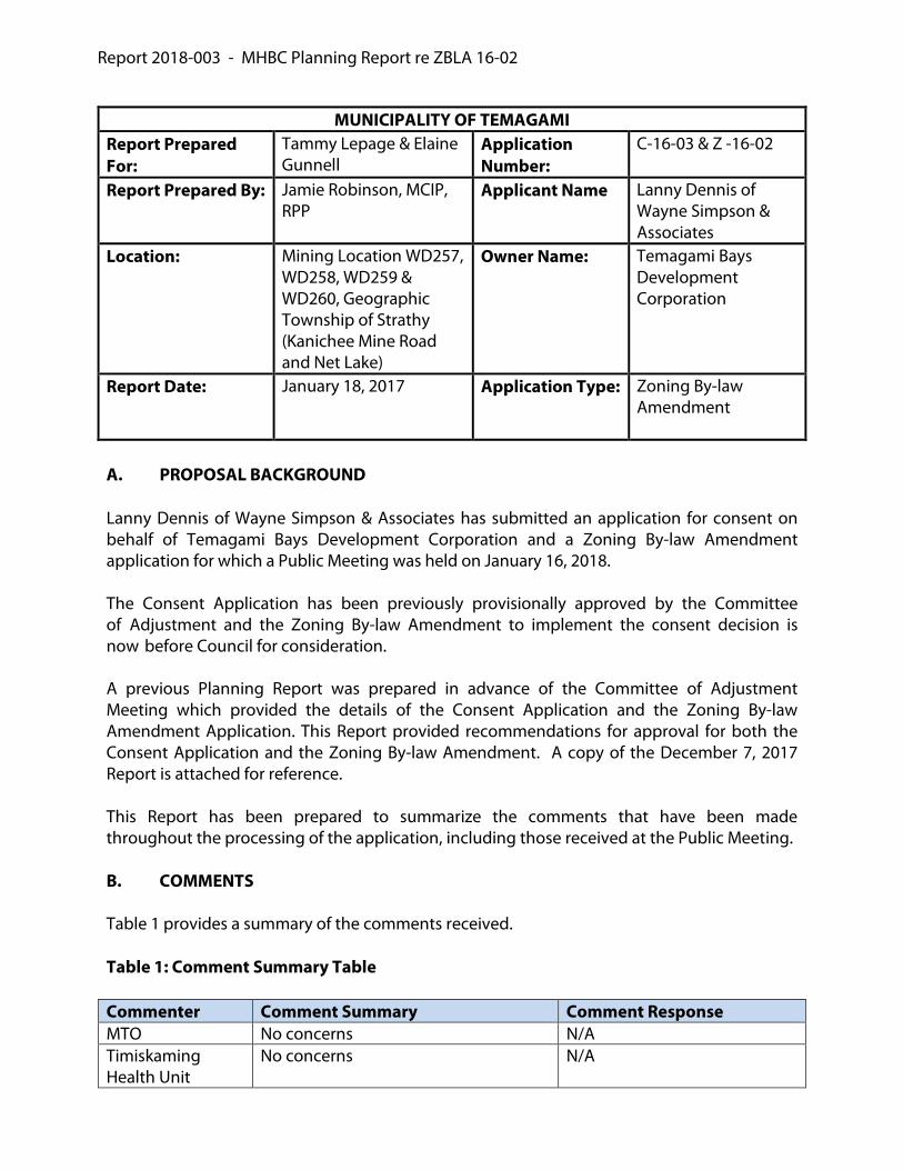
MNRF The MNRF provided comments that can generally be characterized as follows: Septic Systems to be located at least 300 metres from Net Lake or the flow from the systems should travel at least 300 metres to the Lake. Where possible, a 30 metre vegetated cover adjacent to fish habitat across the entire length of the subject lands be retained or established to mitigate negative impacts of development on fish habitat.
The Zoning of the Site and the Site Plan Agreement will establish septic locations that are at least 300 metres from the shore for all lots with the exception of Lot 3. As the site is an existing lot of record, one of the lots is permitted to have a septic system that is within 300 metres of Net Lake. The retained lot, Lot 1 and Lot 2 all have septic locations identified that are more than 300 metres from Net Lake. The EIS identifies the location of fish habitat. The Site Plan control agreement will identify dock locations that are outside
Commenter Comment Summary Comment Response of critical fish habitat and will provide for vegetation protection areas adjacent to the shoreline. The Municipality’s Zoning By-law requires a development setback of 15 metres from the shoreline. The Report prepared by FRI Environmental provides justification for a 30 metre setback to be established from the high water mark. Based on the site specific investigation completed by FRI Environmental, and the mitigation measures outlined in their Report, including Site Plan Control, a 20 metre setback would appear to achieve the MNRF objective of protecting fish habitat.
Judy Evans Provided comments requesting that an adequate area be made available to enable access to Net Lake so that they have an area from which to access their cottage.
As part of the proposal, there are lands to be conveyed to the Municipality for an access to Net Lake. An easement is proposed to be developed over the road.
Rhonda and Darren Etmanski
Provided comments requesting that an adequate area be made available to enable access to Net Lake.
As part of the proposal, there are lands to be conveyed to the Municipality for an access to Net Lake. An easement is proposed to be developed over the road.
John Watkins Provided concerns related to access. An easement is proposed to be developed over the road.
Union Gas No concerns or objections N/A Biff Lowery Concern regarding future lot creation
and the ability to resever the proposed lots in future based on Official Plan
Policy 2.24 of the Official Plan provides the opportunity for a maximum of three lots to be

Commenter Comment Summary Comment Response policy 2.24 that permits three new lots from an existing lot.
created from an existing lot on a private road. The term “existing” in this instance is interpreted to mean “at the time of approval of the Official Plan.” This policy could not be used to support future lot creation on the subject lands.
C. CONCLUSION AND RECOMMENDATION Zoning By-law Amendment Application The updated Environmental Impact Study confirmed the appropriateness of the subject Site to support the proposed development. The comments made on the application have been considered, and in accordance with Table 1, each of the comments have been addressed. The Zoning of the subject lands to the Remote Residential (R2) Exception Zone, Community Use (CU) Exception Zone and Open Space (OS) Exception Zone, in accordance with the attached amendment would be consistent with the PPS, and conform to the Municipality’s Official Plan for the reasons set out in the December 7, 2017 Planning Report. On this basis, it is recommended that Council approve the Zoning By-law Amendment Application by enacting the Zoning By-law attached to this Report. Jamie Robinson, BES, MCIP, RPP Partner
jrobinson
Typewritten Text

MUNICIPALITY OF TEMAGAMIReport Prepared For:
Tammy Lepage & Elaine Gunnell
Application Number:
C-16-03 & Z -16-02
Report Prepared By: Jamie Robinson, MCIP, RPP
Applicant Name Lanny Dennis of Wayne Simpson & Associates
Location: Mining Location WD257, WD258, WD259 & WD260, Geographic Township of Strathy (Kanichee Mine Road and Net Lake)
Owner Name: Temagami Bays Development Corporation
Report Date: December 7, 2017 Application Type: Consent & Zoning By-law Amendment
A. PROPOSAL BACKGROUND Lanny Dennis of Wayne Simpson & Associates has submitted an application for consent on behalf of Temagami Bays Development Corporation. A Zoning By-law Amendment application has also been submitted for which a Public Meeting has been scheduled for December 14, 2017. The Zoning By-law Amendment proposes to zone the subject lands from the Integrated Management Area (IMA) Zone to the Remote Residential (R2) Zone. Through the review of the application it was also determined that portions of the lands should be zoned to, the Community Use (CU) Zone and the Open Space (OS) Zone. This Report has been prepared to consider both the consent and easement, which are before the Committee of Adjustment and the Zoning By-law Amendment which is before Council.
The consent application proposes the creation of three new shoreline residential lots (one retained), with each lot having the ability to accommodate a detached dwelling. The subject lands are comprised of Mining Location WD257, WD258, WD259 & WD260, Geographic Township of Strathy (Kanichee Mine Road and Net Lake) and are located at the shores of Net Lake. The subject lands are accessed by Kanichee Mine Road. The consent application also proposes an easement over the subject lands in favour of the public to enable access to the crownland to the west of the subject lands and access to the proposed lots. Development proposals for the subject lands have a long history. Previously, applications were submitted to the Municipality for a Plan of Subdivision, a Zoning By-law Amendment and a Plan of Condominium. It is also understood that preconsulation for the current consent applications occurred with the Municipality in 2015.
jrobinson
Typewritten Text
ATTACHMENT 1
jrobinson
Typewritten Text
jrobinson
Typewritten Text
jrobinson
Typewritten Text
jrobinson
Typewritten Text
jrobinson
Typewritten Text

An initial Public Hearing was held by the Committee of Adjustment on January 12 of 2017. Based on the comments that were provided, and the recommendations of Staff, the decision was deferred by the Committee of Adjustment Meeting. The Committee of Adjustment deferred the application on the basis of the following:
Details regarding the road have since been provided and an EIS has been completed. B. SITE DESCRIPTION As shown on Figure 1, the subject lands are located west of Highway 11and on the north side of Net Lake. The proposed lot configuration is shown on Figure 2. Figure 1: Subject Lands

Figure 2: Proposed Lot Configuration
The subject lands are located within the Matabitchuan Neighbourhood and are designated Integrated Management Area by the Official Plan. The Zoning By-law for the Municipality of Temagami zones the subject lands as Integrated Management Area (IMA). The subject lands are currently vacant; however, there is an access point to Net Lake on the property, which has historically been utilized by cottagers from the Lake. The subject lands are heavily forested and contain rugged terrain which is characteristic of the area. The subject lands are bordered by a Mining Claim, Net Lake and Crown lands to the west, Net Lake to the north, the TransCanada Pipeline and a shoreline residential property to the east, and Crown lands to the south.
Net Lake has been identified as a Lake that is at Capacity for sustaining Lake Trout. This was confirmed through the previous subdivision process that was undertaken for the site. The characteristics of the retained and severed lands are summarized in Table 1. Table 1: Proposed Lot Characteristic Retained Lot Severed Lot
1 Severed Lot
2 Severed Lot
3 Lot Area (ha)
47.6 43.4 39.9 9.0
Lot Frontage on Net Lake (m)
337 330 315 384
3
2
1
Retained
Access Dedication
Location of
Archaeological
Features
Location of
Easement

The easement is proposed to be 10 metres in width and is proposed to follow Kanichee Mine Road though the subject site. On the western portion of the subject lands, the application has also identified an area of 0.4 hectares of land, to the north of Kanichee Mine Road which is to be dedicated to the Municipality of Temagami and could be used as an access point. On December 15, 2016, the Council of the Municipality of Temagami passed a resolution to accept the dedication of land for the purposes of an access point. This area is proposed to be zoned Community Use (CU) and a Municipal Launch is proposed to be added as a permitted use. The subject lands are accessed by Kanichee Mine Road. Between Highway 11 and the subject lands, Kanichee Mine Road is located on Crown Land, as referenced in a legal opinion obtained on October 3, 2010, from John J. Dooley of the Miller Law Group (Miller). As Kanichee Mine Road traverses the subject lands, it is located on lands owned by the proponent. An easement over Kanichee Mine Road is to be granted in favour of the public to enable access to the lands to the west of the subject lands. It is recommended that a condition of provisional consent require a private road agreement be registered on the title of each lot clearly demonstrating to future owners that service levels on a private road, may not be the same as the level of service experienced on a Municipally maintained road. The supporting studies that were prepared as part of the subdivision application identified that there is an area of cultural significance on the property adjacent to Net Lake. A condition of provisional consent should be the restriction of development on the areas that are subject to these cultural heritage areas. This area is proposed to be zoned Open Space (OS) Exception and development, site alteration and tree removal will not be permitted. Additionally, it is also recommended that the protection of cultural significant areas be achieved by restricting development in these areas though a Site Plan Control. C. POLICY AND REGULATORY CONSIDERATIONS The Provincial Policy Statement The Provincial Policy Statement, 2014 (PPS) was approved on April 30, 2014 by the Ministry of Municipal Affairs and Housing and is applicable to the subject lands. Section 1.1.5.2 of the PPS recognizes resource-based recreational development, such as recreational dwellings, as a permitted use. The proposed application for consent is consistent with the PPS. Section 1.6.4.4 of the PPS contains policies that permit individual on-site sewage services and individual on-site water services where municipal services are not available and provided that the site conditions are suitable for the long-term provision of such services. The supporting studies submitted with the previous subdivision application indicate that the site could accommodate on-site sewage for future development. The proposed consent

applications propose significantly fewer lots than the subdivision application upon which the servicing studies were based. It is anticipated that the subject lands can adequately accommodate individual on-site sewage services for each of the proposed lots. A condition of provisional consent should be the requirement for confirmation from the Health Unit that each of the lots can accommodate an individual sewage system. Section 2.1 of the PPS contains policies that required the protection of natural features and areas for the long term. The following Sections apply:
Section 2.1.5 d) does not permit development and site alteration in significant wildlife habitat;
Section 2.1.6 does not permit development and site alteration in fish habitat, except in accordance with provincial and federal requirements;
Section 2.1.7 does not permit development and site alteration in habitat of endangered species and threatened species, except in accordance with provincial and federal regulations; and,
Section 2.1.8 does not permit development and site alteration on adjacent lands to natural heritage features referenced in Section 2.1.5 and 2.1.6, unless the ecological function of the adjacent lands has been evaluated and it has been demonstrated that there will be no negative impact on the natural features or their ecological function.
An Environmental Impact Study was completed by FRI Environmental to support the previous subdivision application. The study identified that fish habitat would be protected, provided that vegetation buffers along the shoreline are maintained and provided that docks are constructed in accordance with Provincial and Federal Requirements. Since the completion of this Study, changes have occurred to the PPS, species at risk legislation and the Environmental Protection Act. The applicants have retained FRI Environmental to undertake scoped EIS in order to confirm consistency with the PPS. Section 2.2 of the PPS contains policies that apply to water. Section 2.2.1 c) states:
“Planning authorities shall protect, improve or restore the quality and quantity of water by: c) identifying resource systems consisting of ground water features, hydrologic functions,
natural heritage features and areas, and surface water features including shoreline areas, which are necessary for the ecological and hydrological integrity of the watershed;”
Net Lake is a sensitive surface water feature as it is a Lake that supports Lake Trout. The Lake is also at capacity for development. The protection of this feature can be achieved in accordance with the requirements of Section 2.2.1 of the PPS, if the recommendation of the Lake Shore Capacity Assessment Handbook is applied, which requires sewage systems for new lots to be located 300 metres from the lake. The site specific zoning for the site should

include a requirements that septic systems be located 300 metres from the shoreline of Net Lake Section 2.6 of the PPS contains policies that apply to Cultural Heritage and Archaeology. Section 2.6.2 does not permit development and site alteration on lands containing resources, unless the resources have been preserved. Provided the features are protected in accordance with the reports completed as part of the subdivision application, the consent applications would be consistent with this section of the PPS. In order to ensure that the protection of these features, it is recommended that the archaeological features be zoned to an Open Space (OS) Exception Zone as a condition of provisional consent. Subject to the confirmation that the proposed lots would not negatively impact significant wildlife habitat or habitat of endangered species and threatened species on or adjacent to the subject lands, the proposed new lots and implementing Zoning By-law Amendment would be consistent with the polices of the PPS. Northern Ontario Growth Plan The Northern Ontario Growth Plan recognizes that tourism is an important component of the economy of Northern Ontario. If the proposed development incorporates the mitigation measures identified in the supporting studies, the proposed resource-based recreational lots could be considered to conform to the Growth Plan for Northern Ontario. The Municipality of Temagami Official Plan The subject lands are located within the Metabitchuan Neighbourhood and are designated Integrated Management Area. Resource Based Recreational uses are permitted within this designation. The current Official Plan (adopted by Council 2011 and further approved by MMAH) provides policies that apply to remote residential lot creation in the Matabitchuan Neighbourhood in Section 7.3.3.2. The policies of Section 7.3.3.2 note that the Municipality will not assume responsibility for access, snow removal, road maintenance or service by school busses and shall not assume any responsibility for the provision of municipal services such as fire fighting, ambulance, water supply, sewage treatment and garbage collection to remote residential properties. Policy 2.24 identifies circumstances where development on private roads is permitted. One of these circumstances is directly applicable to the subject property. The applicable policy is summarized as follows: 2.24 Development on Private Roads The Municipality may permit remote residential development on the basis of private road access in the following circumstances:
Where an existing patented lot with private road access in the Marten River, Matabitchuan or Backcountry Neighbourhood can be severed so that both the new lot

or lots, to a maximum of three (3) new lots and the retained lot meet all the zoning standards for a lot in the Remote Residential (R2) Zone, as set out in the Zoning Bylaw;
This policy enables the creation of up to three new lots from a lot that has frontage on a private road, provided the severed and retained lots comply to the Remote Residential (R2) Zone standards. The proposed lots comply to the Remote Residential (R2) Zone standards as outlined in Table 3, with the exception of the maximum lot area. Section 2.17 of the Plan contains policies that apply to waterfront development. In accordance with Section 2.17, it is the goal of the Municipality to maintain shorelines and the area between shoreline and buildings in their natural state as a vegetative buffer in order to protect the visual and environmental integrity of lakes. In order to protect natural shorelines the following policies apply:
While the Zoning By-law establishes a minimum lot frontage, a wider lot should
be considered where the extra width will better respond to the natural landscape, shoreline and the character of the waterbody;
Lot lines should follow existing features and terrain and should be configured to minimize conflicts with abutting properties at the shoreline;
The natural waterfront landscape shall prevail with buildings blending into the landscape;
Native species should be used for buffers or where vegetation is being restored; Rock faces, steep slopes, vistas and panoramas should be conserved;
Buildings should not exceed the height of the tree canopy; Building mass and coverage should be limited in relation to the lot size and
frontage; Site alteration on lots should be limited and the maximum amount of natural
vegetation should be retained on the lots; Within the setback area, a Shoreline Activity Area is permitted. The Shoreline
Activity Area is a portion or cumulative portions of a shoreline frontage of a lot where accessory shoreline structures such as boathouses, docks, pumphouses, gazebos and decks are permitted, as well as access to the water for activities such as swimming or boat launching. To maintain an appropriate balance between a natural shoreline and built form, the Shoreline Activity Area should be focused within a defined area and be limited in extent. The extent of the Shoreline Activity Area shall be a function of the shoreline frontage and the primary use of the lot and shall be set out in the Zoning By-law.
The proposed lots are quite large and provide an opportunity for a variety of building locations. Through the Site Plan Control process, the Municipality can ensure that the criteria included in Section 2.17 is satisfied. Section 7.3.3.2 provides lot creation policies for lands in the Matabitchuan Neighbourhood and Section 9.7.1 contains general lot creation policies. The policies contained in Section

7.3.3.2 and Section 9.7.1 of the Official Plan that apply to the proposed application are summarized in Table 2. Table 2: Summary of Official Plan Lot Creation Policies
Policy 7.3.3.2 Remote Residential Lot Creations Through Consents on Private Land
Comments on Conformity
The intended use of the lot conforms to the intent and policies of the Plan and the provisions of the Zoning By-law.
The use of the lot conforms to the intent of the Official Plan and Zoning By-law for the reasons outlined in this Report. Specifically, the proposal conforms to Section 2.24 which permits up to 3 lots from a parcel on a Crown land and the lots generally comply with the standards of the R2 Zone as outlined in Table 3.
The Municipality will not assume responsibility for access, snow removal, road maintenance or service by school buses.
The lands are currently accessed via a Kanichee Mine Road and Kanichee Mine Road is a Private Road. It is recommended that a Private Road agreement be a condition of provisional consent. The agreement would confirm that the Municipality would not take responsibility for the private road and that the service levels may be less than those provided for lots on a municipally maintained road.
The Municipality shall not assume any responsibility for the provision of municipal services such as fire fighting, ambulance, water supply, sewage treatment and garbage collection to remote residential properties.
It is recommended that a private road agreement be required as a condition of consent. The agreement would confirm that the Municipality will not provide services to the lots on a private road.
In creating the lot, regard shall be had to any natural heritage features identified in this Plan.
An Environmental Impact Study was completed as part of the previous application for Plan of Subdivision and an updated Environmental Impact Study has been completed in support of this application. In accordance with the recommendations from the Environmental Report, the proposed development has regard to natural heritage features.
The applicant when required, shall provide a study or studies acceptable to the Municipality that include an inventory of all existing natural and cultural heritage features both on the site and in the water adjacent to the site, including the shoreline characteristics such as type of littoral community and physical characteristics, the anticipated impact of the development and any measures proposed to satisfactorily mitigate the anticipated impacts of the development on the features otherwise, the Municipality will not approve the consent.
A Cultural Heritage Study and Environmental Impact Study were completed as part of the previous subdivision application for the property. These studies concluded that development on the site could occur, subject to specific mitigation measures including siting development within the development envelopes that are identified on Figure 9 of the EIS. The mitigation measures outlined in these reports are being required as conditions of provisional consent.
The soil drainage, and slope conditions on the lot are suitable or can be made suitable for the
The technical reports submitted with the previous subdivision have indicated that the site

proper siting of buildings and the installation of an approved water supply and Class IV sewage disposal system, in accordance with the requirements of Section 2.9.
could support septic systems. Due to the status of Net Lake as a Lake Trout Lake that is at capacity for development, the septic systems are required to be situated 300 metres from the Lake. There appears to be sufficient room on each of the proposed lots to accommodate a sewage system in accordance with this requirement. Committee may wish to include as a condition of provisional consent, the requirement for conformation from the Health Unit that each of the lots can accommodate a septic system.
Where a water well is proposed, the well shall be established and quality and quantity standards proven prior to final consent is granted.
The application indicates that water may be taken from the Lake, or a well may be drilled. On the basis that water could be taken from the Lake, this policy is satisfied.
The fisheries habitat, cultural heritage features, steep or unstable soils, environmentally sensitive areas, and other bio-physical aspects of the consent are not negatively impacted by the development.
These aspects were studied as part of the previous subdivision application. Based on the results of these previous investigations, provided that the mitigation measures outlined in the reports are followed, the proposed development is not anticipated to negatively impact these features.
The lot is not within 500m of a known sanitary landfill site.
We are not aware of any landfill in proximity to the site.
The lot is located at least a minimum distance from an existing tourist lodge, as set out in the Zoning By-law.
N/A
Where access to the lot is by water, adequate long term parking and docking facilities and a receiver for garbage shall be secured to the satisfaction of the Municipality.
N/A
Demonstrated ability that the dock locations are suitable by study and/or approval by the appropriate authority.
Due to the significant shoreline frontage of each lot, we are confident that there is a suitable location for a dock on each property. The previous Environmental works completed as part of the subdivision applications indicated that docks could be supported in accordance with Provincial and Federal requirements. The updated Environmental Report identifies areas of fish habitat and there are locations on each of the proposed lots where a dock could be located outside of critical fish habitat. Site Plan Control should be applied as a condition of provisional consent, and the Site Plan should identify dock locations that are outside of, and setback from areas of critical fish habitat.
Site Plan Control Site Plan Control should be a condition of provisional consent.

Policy 9.7.1 Consents to Sever Patented Land Does the Application Conform? The intended use of the severed and retained parcels conform with the intent and policies of this plan.
Yes
Generally the number of lots created does not exceed three.
Yes – three new lots are proposed.
A registered plan of subdivision is not required. A Plan of subdivision is not required. The size and dimensions of the severed and retained parcels conform to the provisions of the Zoning By-law.
Yes – See Table 3
The application represents an orderly and efficient use of land and the severance would not hinder development of the retained lands.
Yes - the application proposes a density of development (three lots) that is permitted by consent on a private road in the Matabitchuan Neighbourhood.
The size and dimensions of the severed parcel and the retained parcel, are adequate to accommodate the proposed use or uses.
Yes – the proposed lots have significant lot frontage and lot area. A condition of provisional consent will be confirmation from the Health Unit that a septic system can be accommodated on each lot.
Demonstrated ability that the dock locations are suitable by study and/or approval by the appropriate authority.
The proposed lots have a significant amount of lot frontage and the Environmental Impact Study identifies that there are sufficient locations on each lot for the location of a dock outside of critical fish habitat. The lots will be subject to Site Plan Control.
Site Plan Control The lots will be subject to Site Plan Control. Adequate access to the severed and retained parcel can be provided.
The lands are presently accessed by a private road. The Official Plan permits the creation of three lots on an existing private road in the Matabitchuan Neighbourhood. An easement over Kanichee Mine Road is proposed to ensure appropriate access to the proposed lots and to the lands to the west of the subject lands.
The severed parcel is not within 500 metres of a known sanitary landfill site.
We are not aware of any landfill sites in the area. This should be confirmed by the Municipality.
Where central sewage and water facilities are not available, it has been established that the soil and drainage conditions on the severed and retained parcels are suitable or can be made suitable to permit the proper siting of buildings and the installation of an approved water supply and Class IV or VI sewage disposal systems.
The lots have a considerable lot area and we are confident that each lot can accommodate a septic system 300 metres from Net Lake (requirement as Net Lake is at capacity). However, a condition of provisional consent will be included to require confirmation from the Health Unit that septic systems can be accommodated on each lot.
Where a water well is proposed, the well shall be established and quality and quantity standards proven prior to final consent is granted.
Water for each of the lots may be provided by the Lake or by well. This policy is satisfied.
The applicant, when required, has provided a study or studies acceptable to the Municipality
This study was completed as part of the previous subdivision application. Since the completion of

that include an inventory of all existing natural and cultural heritage features both on the site and in the water adjacent to the site, including the shoreline characteristics such as type of littoral community and physical characteristics, the anticipated impact of the development and any measures proposed to mitigate the anticipated impacts of the development on the features.
the Environmental Impact Study, and the applicant has completed an Environmental Impact Study as part of this development proposal. The Study considered the policies of the PPS and the Municipalities Official Plan and established development envelopes to ensure the protection of natural features.
The financial impacts on the Municipality have been considered.
There are no anticipated financial impacts on the Municipality.
Based on our review, the proposed lots would satisfy these requirements and it is submitted that the applications for consent would conform to the policies of the Official Plan. Municipality of Temagami Zoning By-law The consent application proposes the creation of three new lots and one retained lot; and easement is also proposed. The lands are currently zoned Integrated Management Area (IMA) and an implementing Zoning By-law Amendment application has been submitted to zone the subject lands to the Remote Residential (R2) Zone. Through this review it was also identified that portions of the site should be zoned to the Community Use (CU) Exception Zone, and the Open Space (OS) Exception Zone. The consent approval will be conditional upon the approval of the Zoning By-law Amendment. Table 1 below provides a summary of the Rural Residential (R2) Zone performance standards and their application to the subject lands. Table 3: Zoning By-law 06-650 - Section 7.5 Remote Residential (R2) Zone Provisions
Provision Description
Required Retained Lot
Severed Lot 1
Severed Lot 2
Severed Lot 3
Minimum Lot Frontage (m)
60 337 330 315 384
Minimum Lot Area (ha)
0.8 (1.0 with
drilled well)
47.6 43.4 39.9 9.0
Maximum Lot Area (ha)
1.5 47.6 43.4 39.9 9.0
Site Specific Zoning is required for all lots to permit a Maximum Lot Area that is more than 1.5 hectares D. COMMENTS Table 4 provides a summary of the comments that were received by resident and agencies.

Table 4: Comment Summary Table Commenter Comment Summary Comment Response MTO No concerns N/A Timiskaming Health Unit
No concerns N/A
Trans Canada Pipelines
Trans Canada Pipelines recommended that the following be included as conditions of provisional consent: That the landowner be required to
entire into an agreement with TransCanada to be registered on title as follows: o The conditions restriction or
covenants specified by TransCanada PipeLines Limited (TransCanada) shall be registered against title (by agreement) in relation to the “Lands” by way of application to register conditions, restrictions or covenants as applicable, pursuant to the Land Titles Act, or any amendments thereto.
TransCanada also provided language to be included in the agreement required by the condition.
MNRF The MNRF provided comments that can generally be characterized as follows: Septic Systems to be located at least 300 metres from Net Lake or the flow from the systems should travel at least 300 metres to the Lake. Where possible, a 30 metre vegetated cover adjacent to fish habitat across the entire length of the subject lands be retained or established to mitigate negative impacts of development on fish habitat.
The Zoning of the Site and the Site Plan Agreement will establish septic locations that are at least 300 metres from the shore for all lots with the exception of Lot 3. As the site is an existing lot of record, one of the lots is permitted to have a septic system that is within 300 metres of Net Lake. The retained lot, Lot 1 and Lot 2 all have septic locations identified that are more than 300 metres from Net Lake. The EIS identifies the location of fish habitat. The Site Plan

control agreement will identify dock locations that are outside of critical fish habitat and will provided for vegetation protection areas adjacent to the shoreline. The Municipality’s Zoning By-law requires development setback of 15 metres from the shoreline. The Report prepared by FRI Environmental provides justification for a 30 metre setback to be established from the high water mark. Based on the site specific investigation completed by FRI Environmental, and the mitigation measures outlined in their Report, including Site Plan Control, a 20 metres setback would appear to achieve the MNRF objective of protecting fish habitat.
Judy Evans Provided comments requesting that an adequate area be made available to enable access to Net Lake so that they have an area from which to access their cottage.
As part of the proposal, there are lands to be conveyed to the Municipality for an access to Net Lake. An easement is proposed to be developed over the road.
Rhonda and Darren Etmanski
Provided comments requesting that an adequate area be made available to enable access to Net Lake.
As part of the proposal, there are lands to be conveyed to the Municipality for an access to Net Lake. An easement is proposed to be developed over the road.
John Watkins Provided concerns related to access. An easement is proposed to be developed over the road.

E. ZONING BY-LAW AMENDMENT To facilitate the creation of the three severed and one retained lot, the subject lands are required to be zoned to the Remote Residential (R2) Zone. An exception to the Remote Residential (R2) Zone is also required to remove Section 7.5.2 c) as an applicable requirement, as each of the lots are over 1.4 hectares in size. Additionally, the area of the subject lands to be conveyed to the Municipality for an access point to Lake Temagami is recommended to be zoned to the Community Use (CU) Exception Zone. The exception is to permit a municipal launch in the Community Use (CU) Zone. In order to protect the archaeological and cultural features that have been identified on the subject lands, these lands are proposed to be zoned to the Open Space (OS) Exception Zone to restrict development, site alteration and tree removal in the area of identified features. The updated Environmental Impact Study confirmed that development would not negatively impact potential significant wildlife habitat or habitat of endangered species and threatened species on or adjacent to the property. The Study concluded that the proposal would be consistent with the PPS and conform to the Municipality of Temagami Official Plan. The Zoning of the subject lands to the Remote Residential (R2) Exception Zone, Community Use (CU) Exception Zone and Open Space (OS) Exception Zone, in accordance with the attached amendment would be consistent with the PPS, and conform to the Municipality’s Official Plan. F. CONCLUSION AND RECOMMENDATION Consent Application – For Committee of Adjustment Based on our review of the consent application, and the supporting EIS, the applications are consistent with the PPS, and conform to the Municipality’s Official Plan. It is recommended that the Committee of Adjustment provisionally approval Consent Application C-16-03 to create three new shoreline lots and the access easement in accordance with the application sketch provided, subject to the following conditions of provisional consent:
1. Preparation of a Reference Plan for the proposed lots, the road easement and the
lands to be dedicated to the Municipality. The Reference Plan must also recognize the area of archaeological significance to be zoned as a Part on the Reference Plan and the Reference Plan must be substantially in compliance with the application sketch and must be prepared to the satisfaction of the Municipality.
2. Preparation of an Easement Plan and the preparation of easement documents to be registered against the proposed lots for the use of the road by the public.
3. The entering into of a Site Plan Control Agreement for each lot. The Site Plan Control Agreement shall recognize the location of driveways, building envelopes, dock

locations and vegetation protection areas adjacent to the shoreline where a tree removal is only permitted for a path to access the water and for hazardous trees.
4. The recognition of the development envelopes in accordance with the EIS.
5. The entering into of a private road agreement to be registered on the title of each lot.
6. Confirmation from the Health Unit that an individual sewage system can be accommodated on each lot.
7. The completion of a Zoning By-law Amendment to Zone the subject lands to permit residential development, protect the location of areas of archaeological significance; to restrict development in proximity to the shoreline in accordance with the recommendations of the FRI EIS; and, and to permit a municipal access point to Lake Temagami.
8. The dedication of lands as outlined in the application sketch to the Municipality of Temagami for the purposes of an access point to Lake Temagami.
9. The payment of all professional fees incurred by the Municipality. 10. The standard conditions of the Municipality.
Zoning By-law Amendment Application – For Council The updated Environmental Impact Study confirmed the appropriateness of the subject site to support the proposed development. The Zoning of the subject lands to the Remote Residential (R2) Exception Zone, Community Use (CU) Exception Zone and Open Space (OS) Exception Zone, in accordance with the attached amendment would be consistent with the PPS, and conform to the Municipality’s Official Plan. On this basis, it is recommended that Council approve the Zoning By-law Amendment Application by enacting the Zoning By-law attached to this Report. Jamie Robinson, BES, MCIP, RPP Partner
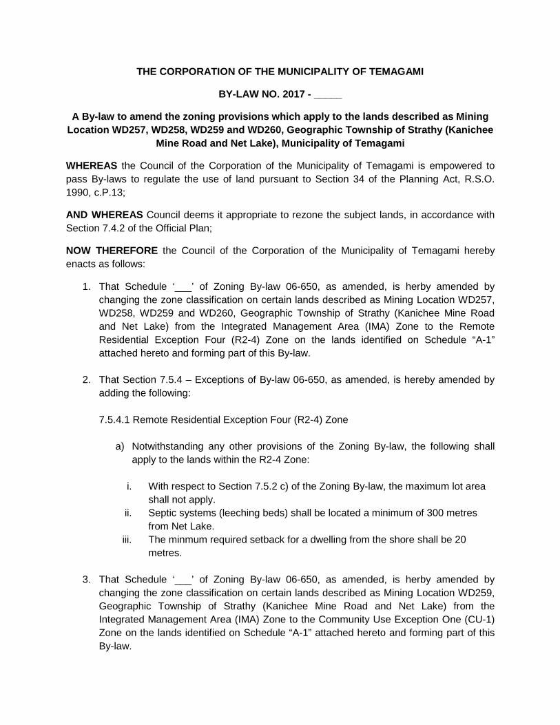
THE CORPORATION OF THE MUNICIPALITY OF TEMAGAMI
BY-LAW NO. 2017 - _____
A By-law to amend the zoning provisions which apply to the lands described as Mining Location WD257, WD258, WD259 and WD260, Geographic Township of Strathy (Kanichee
Mine Road and Net Lake), Municipality of Temagami
WHEREAS the Council of the Corporation of the Municipality of Temagami is empowered to pass By-laws to regulate the use of land pursuant to Section 34 of the Planning Act, R.S.O. 1990, c.P.13;
AND WHEREAS Council deems it appropriate to rezone the subject lands, in accordance with Section 7.4.2 of the Official Plan;
NOW THEREFORE the Council of the Corporation of the Municipality of Temagami hereby enacts as follows:
1. That Schedule ‘___’ of Zoning By-law 06-650, as amended, is herby amended by changing the zone classification on certain lands described as Mining Location WD257, WD258, WD259 and WD260, Geographic Township of Strathy (Kanichee Mine Road and Net Lake) from the Integrated Management Area (IMA) Zone to the Remote Residential Exception Four (R2-4) Zone on the lands identified on Schedule “A-1” attached hereto and forming part of this By-law.
2. That Section 7.5.4 – Exceptions of By-law 06-650, as amended, is hereby amended by adding the following: 7.5.4.1 Remote Residential Exception Four (R2-4) Zone
a) Notwithstanding any other provisions of the Zoning By-law, the following shall apply to the lands within the R2-4 Zone:
i. With respect to Section 7.5.2 c) of the Zoning By-law, the maximum lot area shall not apply.
ii. Septic systems (leeching beds) shall be located a minimum of 300 metres from Net Lake.
iii. The minmum required setback for a dwelling from the shore shall be 20 metres.
3. That Schedule ‘___’ of Zoning By-law 06-650, as amended, is herby amended by changing the zone classification on certain lands described as Mining Location WD259, Geographic Township of Strathy (Kanichee Mine Road and Net Lake) from the Integrated Management Area (IMA) Zone to the Community Use Exception One (CU-1) Zone on the lands identified on Schedule “A-1” attached hereto and forming part of this By-law.
jrobinson
Typewritten Text
jrobinson
Typewritten Text
ATTACHMENT 2
jrobinson
Typewritten Text
4. That Section 7.22.4 – Exceptions of By-law 06-650, as amended, is hereby amended by
adding the following: 7.22.4.1 Community Use Exception One (CU-1) Zone
a) Notwithstanding any other provisions of the Zoning By-law, the following shall apply to the lands within the CU-1 Zone: • In addition to the permitted uses listed under Section 7.22.1 of the Zoning By-
law, a Municipal Launch shall also be permitted.
5. That for the purposes of Section 7.22.4.1, a Municipal Launch shall be defined as:
“shall mean land used for parking vehicles, docks and docking of boats, to facilitate water access to one or more shoreline properties.”
6. That Schedule ‘___’ of Zoning By-law 06-650, as amended, is herby amended by
changing the zone classification on certain lands described as Mining Location WD257, Geographic Township of Strathy (Kanichee Mine Road and Net Lake) from the Integrated Management Area (IMA) Zone to the Open Space Exception One (OS-1) Zone on the lands identified on Schedule “A-1” attached hereto and forming part of this By-law.
7. That Section 7.21.4 – Exceptions of By-law 06-650, as amended, is hereby amended by adding the following: 7.21.4.1 Open Space Exception One (OS-1) Zone
a) Notwithstanding any other provisions of the Zoning By-law, the following shall apply to the lands within the OS-1 Zone: • No development, site alteration or tree removal is permitted to ensure the
protection of this area which contains identified archaeological and cultural heritage features.
This By-law will take effect on the date of its passage, subject to the provisions of Section 34(30) and (31) of the Planning Act, R.S.O. 1990, c.P.13. READ A FIRST AND SECOND TIME on the ___________ day of _______________ 2017. READ A THIRD TIME and finally passed this __________ day of _______________ 2017.

_____________________________ _____________________________ Lorie Hunter, Mayor Elaine Gunnell, Municipal Clerk