MUNICIPAL CODE TITLE 9 Zoning - Oregon of Yachats Zoning Ordinance P. 5 “Club” means any...
78
City of Yachats Zoning Ordinance P. 1 City of Yachats MUNICIPAL CODE TITLE 9 Zoning
Transcript of MUNICIPAL CODE TITLE 9 Zoning - Oregon of Yachats Zoning Ordinance P. 5 “Club” means any...

City of Yachats Zoning Ordinance
P. 1
City of Yachats
MUNICIPAL CODE TITLE 9
Zoning
City of Yachats Zoning Ordinance
P. 2
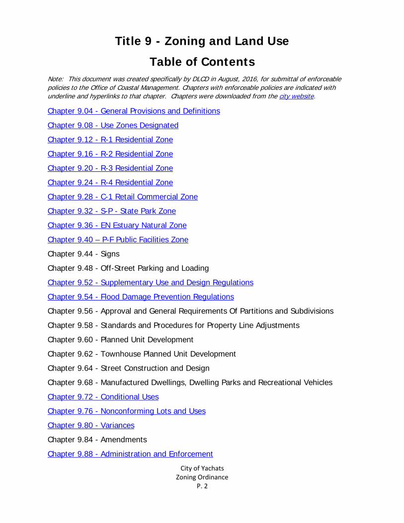
Title 9 - Zoning and Land Use
Table of Contents Note: This document was created specifically by DLCD in August, 2016, for submittal of enforceable policies to the Office of Coastal Management. Chapters with enforceable policies are indicated with underline and hyperlinks to that chapter. Chapters were downloaded from the city website.
Chapter 9.04 - General Provisions and Definitions
Chapter 9.08 - Use Zones Designated
Chapter 9.12 - R-1 Residential Zone
Chapter 9.16 - R-2 Residential Zone
Chapter 9.20 - R-3 Residential Zone
Chapter 9.24 - R-4 Residential Zone
Chapter 9.28 - C-1 Retail Commercial Zone
Chapter 9.32 - S-P - State Park Zone
Chapter 9.36 - EN Estuary Natural Zone
Chapter 9.40 – P-F Public Facilities Zone
Chapter 9.44 - Signs
Chapter 9.48 - Off-Street Parking and Loading
Chapter 9.52 - Supplementary Use and Design Regulations
Chapter 9.54 - Flood Damage Prevention Regulations
Chapter 9.56 - Approval and General Requirements Of Partitions and Subdivisions
Chapter 9.58 - Standards and Procedures for Property Line Adjustments
Chapter 9.60 - Planned Unit Development
Chapter 9.62 - Townhouse Planned Unit Development
Chapter 9.64 - Street Construction and Design
Chapter 9.68 - Manufactured Dwellings, Dwelling Parks and Recreational Vehicles
Chapter 9.72 - Conditional Uses
Chapter 9.76 - Nonconforming Lots and Uses
Chapter 9.80 - Variances
Chapter 9.84 - Amendments
Chapter 9.88 - Administration and Enforcement
City of Yachats Zoning Ordinance
P. 3
Chapter 9.04 - General Provisions and Definitions Section 9.04.010 Short title.
This title shall be known as the city of Yachats zoning and land use ordinance. (Ord. 73E, 1992) Section 9.04.020 Purpose.
The purpose of this title is to promote the public health, safety and general welfare and to assist in carrying out comprehensive plans for the city including all future lands and subdivisions annexed into the incorporated city. (Ord. 73E, 1992) Section 9.04.030 Definitions
As used in this title: “A-frame or sandwich sign” means an advertising device which is ordinarily two-sided and in the shape of an “A” or some variation thereof, located on the ground and not permanently affixed. “Access” means the way or means by which pedestrians and vehicles enter and leave property. “Accessory structure or accessory use” means a structure or use incidental and subordinate to the main use of a property and located on the same lot as the main use. “Alley” means a minor way for secondary access to properties which abut other streets. “Alter” means any change, addition or modification of construction or occupancy of a building or structure. “Amendment” means a change in wording, content or substance of this title, or a change in the zone boundaries or area district boundaries upon the zoning map. “Apartment” means a dwelling unit as defined in this section. “Apartment hotel” means a building or portion thereof designed for or containing both individual guest rooms or suites of rooms and dwelling units, but excluding all facilities coming within the definition of “bed and breakfast facility.” “Apartment house” means a building or portion thereof designed, built, rented, leased, let or hired out to be occupied, or which is occupied or is the home or residence of three or more families living independently of each other and doing their own cooking in the building, and shall include flats and apartments. “Automobile service station” means a premises used for supplying direct to the consumer at retail; gasoline, oil, minor accessories and services for automobiles. “Awning” means a movable shelter supported entirely from the exterior wall of a building and of such a type which can be retracted, folded or collapsed against the face of a supporting building. “Awning, manufactured dwelling” means any stationary structure, permanent or demountable, used in conjunction with a manufactured dwelling, other than a window awning, for the purpose of providing shelter from the sun and rain, and having a roof with supports and not more than one wall or storage cabinet substituting for a wall. “Banner” means a non-rigid sign designed to be hung either with or without a frame. “Basement” means a story partly or wholly underground.

City of Yachats Zoning Ordinance
P. 4
“Bed and breakfast facility” means a single-family dwelling containing rooms for rent in accordance with Section 9.72.050. “Block” means an area of land which may be bounded on all sides by streets, unsubdivided land, water courses, or any combination thereof. Boarding House. See “Rooming house.” “Boundary line” means the line defining the perimeter of a lot, parcel, area or tract of land. “Boundary line, front line” means the boundary line separating the lot or parcel from the street, other than an alley. In the case of a corner lot or parcel, the shortest boundary line along a street, other than an alley; or, in the case of a lot or parcel which does not front directly upon a public street, that line toward which most houses in the immediate area face. “Boundary line, rear line” means a boundary line which is opposite and most distant from the front line. In the case of an irregular, triangular, or other shaped lot or parcel, a line a minimum of ten feet in length, within the lot or parcel parallel to and at a maximum distance from the front line. “Boundary line, side line” means any boundary line not a front or rear line. “Bridge crossing” means the portion of a bridge spanning a waterway or wetlands, not including supporting structures or fill. “Bridge crossing support structure” means piers, piling and similar structures necessary to support a bridge span but not including fill for causeways or approaches. “Building” means a structure built or assembled for the support, shelter or enclosure of persons, animals, chattels or property of any kind. “Built” means created by assembling basic elements such as foundations, floors, walls, roofs, plumbing and wiring systems, etc., by following step-by-step construction procedures. “Cabana” means a stationary, lightweight structure, which may be prefabricated, or demountable, with two or more walls, used adjacent to and in conjunction with a manufactured dwelling to provide additional living space meant to be moved with the manufactured dwelling. “Canopy” means a structure other than an awning made of cloth, metal or other material with a frame attached to the building and also supported by a frame on the ground. “Carport” means a stationary structure consisting of a roof with its supports and not more than one wall or storage cabinet substituting for a wall and used for sheltering a motor vehicle. Cellar. See “Basement.” “Cemetery” means land used or intended to be used for the burial of the dead and dedicated for cemetery purposes, including a columbarium, crematory, mausoleum or mortuary when operated in conjunction with and within the boundary of such cemetery. “Church” means a building, together with its accessory buildings and uses, where persons regularly assemble for worship and which is maintained and controlled by a religious body organized to sustain public worship. “City” means the incorporated city of Yachats, Oregon. “City council” means the governing body of the city of Yachats. “Clinic” means a building utilized by persons licensed by the state of Oregon to treat or analyze medical or surgical needs of humans.

City of Yachats Zoning Ordinance
P. 5
“Club” means any organization, group or association supported by the members thereof, the purpose of which is to render a service but not carried on as a business. “Common property” means a lot(s) together with the improvements thereon, the use and enjoyment of which are shared by owners and occupants of individual building sites in a planned unit development or standard subdivision. “Community center” means a facility owned and operated by a governmental agency or a nonprofit community organization, provided that the primary purpose of the facility is for recreation, social welfare, community improvement, or public assembly, and further provided that no permanent commercial eating or drinking facilities shall be operated on the premises. “Comprehensive plan” means the comprehensive land use plan of the city of Yachats. This plan is the document which: (1) interrelates functional and natural systems and activities related to the use of land and water; and (2) is adopted, reviewed and refined by the city as a guide to growth and improvement within the city. “Condominium” means a system of ownership under which one may own an individual unit in an apartment or other building complex and share in the ownership of common elements such as the land; also refers to the buildings that are owned under such a system. Convalescent. See “Nursing home.” “County” means the county of Lincoln, Oregon. “Day care center” means an institution, establishment or place not a part of the public school system, other than a family day care provider, in which are commonly received at one time five or more children not related by parentage to the provider of the day care service, fourteen (14) years of age or under, for the purpose of being given board, care or training, apart from their parents or guardians for compensation or reward. “Day nursery” means any institution, establishment or place, other than a family day care provider, in which are commonly received at one time three or more children not of common parentage, under the age of six years, for the purpose of being given board, care or training apart from their parents or guardians for compensation or reward. “Deck/porch” means an outside walking area, the floor of which is elevated more than eight inches from grade. “Deed restrictions” means a private, contractual agreement to limit the use (e.g., building height) of real property; a deed covenant. The city assumes no responsibility for enforcement of covenants and restrictions between private parties. “Density” means the number of units per acre. “Design” means the design of any street or alley alignments, grade or width, alignment of width of easements and rights-of-way for drainage or irrigation purposes and sanitary facilities, and lot area, width or layout. “Development” means work done on any site resulting in physical changes to that site, including, but not limited to, grading and/or excavation, vegetation removal and/or any construction or placement of facilities on that site. “Dock for marina use” means a floating moorage facility constructed perpendicular or parallel to the shoreline.

City of Yachats Zoning Ordinance
P. 6
“Double frontage lot” means a lot having frontage on two parallel or approximately parallel streets. “Double wide manufactured dwelling” consists of two coach units constructed on two separate chassis that are combined horizontally at the site to complete the living unit. “Dredging” means the removal of materials from a wetland or body of water for channel deepening, realignment, boat basin or other uses. “Driveway” means a minor private way used by vehicles and pedestrians on a lot or for common access to a small group of lots or common facilities. “Dwelling” means a building or portion thereof which is occupied in whole or in part as a residence or sleeping place, either permanently or temporarily by one or more families, but excluding hotels, motels and tourist courts. Dwelling, Multifamily. “Multifamily dwelling” means a building containing three or more dwelling units. Dwelling, Single-Family. “Single-family dwelling” means a building designed or used exclusively for the occupancy of one family and having kitchen facilities for only one family. Dwelling, Two-Family. “Two-family dwelling” means one building containing two dwelling units (duplex). “Dwelling unit” means one or more rooms designed for permanent occupancy by one family and having not more than one kitchen facility. “Easement” means a right of usage of real property granted for a specific purpose by an owner to specific persons, firms, corporations, or the public. “Erect” means to build, construct, attach, hang, place, suspend or affix; in the context of signs, shall also include the painting of wall signs. “Estuarine enhancement” means an action which results in a long term improvement of existing estuarine functional characteristics and processes that is not the result of a restoration action or the creation of additional estuarine habitat. This activity may include snag removal. “Expando” means a room or rooms that folds, collapses or telescopes into a manufactured dwelling during transport and which can be expanded at the site to provide additional living space. “Factory built dwelling” means a dwelling unit built substantially or entirely at a place other than the residential site, meeting county and state building code requirements, and including prefabricated or modular homes and excluding manufactured dwellings. “Family” means an individual or two or more persons related by blood, marriage, adoption or legal guardianship, living together as one housekeeping unit using one kitchen, and providing meals or lodging to not more than two additional persons; or a group of not more than three unrelated persons, living together as one housekeeping unit using one kitchen. “Family day care provider” means a day care provider who provides day care in the provider’s home in the family living quarters to no more than twelve (12) children including children of the provider, regardless of full-time or part-time status. “Fence” means an unroofed barrier or an unroofed enclosing structure such as masonry, ornamental iron, woven wire, wood pickets of solid wood or any other material used as an unroofed barrier to light, sight, air or passage.

City of Yachats Zoning Ordinance
P. 7
Fence, Sight-Obscuring. “Sight-obscuring fence” consists of either a continuous fence, wall, evergreen planting, or combination thereof, constructed and/or planted so as to effectively screen the particular use from view. “Fill” means the placement by man of sand, sediment or other material, usually in submerged lands or wetlands, to create new uplands or raise the elevation of land. “Finished grade” means the plane on which the footprint of the structure meets the ground. “Flag lot” means a lot meeting minimum lot area depth and width requirements, excluding the access portion of the lot. “Floor area” means the sum of the gross horizontal areas of the several floors of a building, measured from the exterior faces of the exterior walls or from the center line of walls separating two buildings, but not including: 1. Uncovered steps or fire escapes; 2. Accessory water towers or cooling towers; 3. Accessory off-street parking or loading spaces. “Garage” means a building or portion thereof in which a motor vehicle is stored, repaired or kept. Garage, Private. “Private garage” means a detached accessory building or portion of a main building for the parking or temporary storage of automobiles in which no business, occupation or service is provided for or is in any way conducted. Garage, Public. “Public garage” means a building, other than a private garage, used for the care, repair or equipping of motor vehicles, or where such vehicles are parked or stored for compensation, hire or sale. “Grade” means the elevation of the ground at the midpoint from all corners of a building, post construction. “Height of building” means the vertical distance from the average finished grade to the highest point of the building plus any fill above the natural grade. To determine building height, calculate the average building height for each side: Add the shortest building height and the tallest building height, then divide the two building heights by two (2). Add together the average height for each side and divide by the number of sides.

City of Yachats Zoning Ordinance
P. 8
“High water line or mark” means the high water elevation as shown on the county assessor’s records, or as determined by the county surveyor, based upon the line where normal high water elevation results in a pronounced change in vegetation characteristics. “Home occupation” means a business, profession or other economic activity conducted full or part-time in the principal residence and/or accessory structure of the person conducting the business. “Homeowners association” means an incorporated, nonprofit corporation to operate under recorded land agreement through which: (1) each lot owner in a planned unit development or other described land area is automatically a member; and (2) each lot is automatically subject to a charge for a proportionate share of the expenses for the organization’s activities such as maintaining a common property. “Homes for the aged or infirm” means any home or institution, other than a residential home or residential facility, that provides board and domiciliary care for compensation to three or more persons who are of the age of sixty-five (65) years or more, or persons less than sixty-five (65) years, who by reasons of infirmity, require domiciliary care. “Hotel” means any building containing guest rooms which are rented or hired out to be occupied for sleeping purposes for guests, excluding any facility which meets the definition of “bed and breakfast facility.” Illumination, External. “External illumination” means illumination of a sign by an artificial source of light not contained within the sign itself. Illumination, Internal. “Internal illumination” means illumination of a sign by an artificial source of light contained within the sign itself, including neon or other gas-filled light. “Interpretation” means that the provisions of this title shall be held to be the minimum requirements fulfilling its objectives. Where the conditions imposed by any other provisions of this title are less restrictive than comparable conditions imposed by any other ordinance, resolution or regulation,

City of Yachats Zoning Ordinance
P. 9
the provisions which are more restrictive shall govern. The only exception would be a planned unit development (P.U.D.). “Junk yard” means any property utilized for breaking up, dismantling, sorting, storing, distributing, buying or selling of any scrap, waste material, junk or used equipment or machinery of any nature. “Landscape” means to improve or ornament by landscape architecture or gardening appropriate to the scale of the development. “License” means a certificate for operation issued by the city pursuant to any city ordinances. “Loading space” means an off-street space or berth on the same lot with a main building or contiguous to a group of buildings, for the temporary parking of a commercial vehicle while loading or unloading merchandise or materials, and which abuts upon a street, alley or other appropriate means of access. “Lot” means a unit of land that is created by a subdivision of land. “Lot area” means the total area within the lot lines of a lot measured on a horizontal plane. Lot, Corner. “Corner lot” means a lot abutting on two or more streets, other than an alley, at their intersection. “Lot depth” means the average horizontal distance between the front lot line and the rear lot line. Lot, Double Frontage. See “Double frontage lot.” Lot, Interior. “Interior lot” means a lot other than a corner lot. “Lot line” means the property line bounding a lot. Lot Line, Front. “Front lot line” means the property line separating the lot from the street, other than an alley. In the case of a corner lot, the shortest property line along a street other than an alley; or, in a case where the lot does not front directly upon a public street, that lot line toward which most houses in the immediate area face. Lot Line, Rear. “Rear lot line” means the property line which is opposite and most distant from the front lot line. In the case of an irregular, triangular, or other shaped lot, a line ten feet in length, within the lot, parallel to and at a maximum distance from the front lot line. Lot Line, Side. “Side lot line” means any property line not a front or rear lot line. “Lot width” means the average horizontal distance between the side lot lines, ordinarily measured parallel to the front lot line. “Main building” means a building within which is conducted the principal use permitted on the lot, as provided by this title. “Maintenance and repair (estuarine areas)” means the work of keeping an existing structure or facility in good working order or in conformance with current engineering or building codes, or of restoring a structure or facility to sound condition after damage or injury. Maintenance and repair is confined to the same geographic area as the existing structure or facility, and does not result in an increase in floor area or surface area. Replacement of bridge crossing support structures and bridge approach ramps may be considered a form of maintenance if the resulting bridge support structure or ramp is the minimum size necessary to accommodate the same number of traffic lanes as exist on that portion of the highway. “Manufactured dwelling” means:
City of Yachats Zoning Ordinance
P. 10
1. A residential trailer, a structure constructed for movement on the public highway, that has sleeping, cooking and plumbing facilities, that is intended for human occupancy, is being used for residential purposes and was constructed before January 1, 1962; 2. A mobile home, a structure constructed for movement on the public highways, that has sleeping, cooking and plumbing facilities, that is intended for human occupancy, is being used for residential purposes and was constructed between January 1, 1962 and June 15, 1976, and met the construction requirements of Oregon mobile home law in effect at the time of construction; 3. A manufactured home, a structure constructed for movement on the public highways, that has sleeping, cooking and plumbing facilities, that is intended for human occupancy, is being used for residential purposes and was constructed in accordance with federal manufactured housing construction and safety standards and regulations in effect at the time of construction. “Manufactured dwelling” does not mean any building or structure subject to the structural specialty code adopted pursuant to ORS 455.100 to 455.450 or any unit identified as a recreational vehicle by the manufacturer. “Manufactured dwelling park” means any place where four or more manufactured dwellings as defined in ORS 446.003 are located within five hundred (500) feet of one another on a lot, tract or parcel of land under the same ownership, the primary purpose of which is to rent space or keep space for rent to any person for a charge or fee paid or to be paid for the rental or use of the facilities or to offer space free in connection with securing the trade or patronage of such person. “Manufactured dwelling park” does not include a lot or lots located within a subdivision being rented or leased for occupancy by no more than one manufactured dwelling per lot if the subdivision was approved by the city under an ordinance adopted pursuant to ORS 92.010 to 92.190. “Manufactured dwelling space” means a plot of ground within a manufactured dwelling park that is designed for the accommodation of one manufactured dwelling. Manufactured Home. See subsection 3 of the definition of “Manufactured dwelling.” “Marina” means a commercial boat launch, moorage or similar facility which may include dry or wet boat storage and boathouses. “Marquee” means a permanent roofed structure attached to and supported by the building and projecting over public property. “Mean high water” means the average height of the high waters over a nineteen (19) year tidal cycle (as per U.S.G.S. definitions). “Mean higher high water” means the average height of the higher high waters over a nineteen (19) year tidal cycle (as per U.S.G.S. definitions). “Mean low water” means the average height of the low waters over a nineteen (19) year tidal cycle (as per U.S.G.S. definitions). “Mean sea level” means the average height of the surface of the sea for all stages of the tide usually determined from hourly height readings over the nineteen (19) year tidal cycle (as per U.S.G.S. definitions). “Mitigation” means the creation, restoration or enhancement of an estuarine area to maintain the functional characteristics and processes of the estuary, such as its natural biological productivity, habitats and species diversity, unique features and water quality. “Mobile home” See subsection 2 of the definition of “Manufactured dwelling”

City of Yachats Zoning Ordinance
P. 11
“Mobile Home Park” See “Manufactured dwelling park” “Modular home” means a dwelling unit, constructed partly on-site, consisting of some prefabricated members; excluding manufactured homes. “Mobile vending unit” means any motorized or non-motorized vehicle, trailer, kiosk, pushcart, stand, display, blanket, ground covering or other device designed to be portable and not permanently attached to the ground from which any goods, wares, merchandise or food are peddled, vended, sold, served, displayed, offered for sale or given away. This includes any display consisting solely of the goods, wares or merchandise being peddled, sold, served, displayed or offered for sale. “Motel” means a series of sleeping units, each having a separate entrance, composed of one or more bedrooms and bathroom, excluding any facility which meets the definition of “bed and breakfast facility” Motor Home. See “Recreational vehicle” “Natural grade” means the grade prior to grading or fill, and is defined as where the roots and stems meet to form the natural elevation of the lot or the grade that existed at the date of the adoption of this ordinance (February 13, 2008). Natural grade is the grade prior to cutting or filling. “Nonconforming lot” means a lot which does not meet the area or width requirements of the zone in which it is located. “Nonconforming structure or use” means a lawful structure or use, existing at the time the ordinance codified in this title or any amendment thereto becomes effective, and which does not conform to the requirements of the zone in which it is located. “Notification area” means the area two hundred fifty (250) feet in all directions of the affected property excluding road or street rights-of-way. “Nursing home” means any home, place or institution which operates and maintains facilities providing convalescent or nursing care, or both, for a period exceeding twenty-four (24) hours for two or more ill or infirm patients not related to the nursing home administrator, or owner, by blood or marriage. Convalescent care may include, but need not be limited to, the procedures commonly employed in nursing and caring for the sick. A nursing home includes rest homes and convalescent homes, but does not include a boarding home for the aged, a residential home, a residential facility, a retirement home, hotel, hospital or a licensed chiropractic facility. “Ocean flooding” means the flooding of lowland areas by salt water owing to tidal action, storm surge, or tsunamis (seismic sea waves). Land forms subject to ocean flooding include beaches, marshes, coastal lowlands, and low-lying interdune areas. Areas of ocean flooding are mapped by the Federal Emergency Management Agency (FEMA). Ocean flooding includes areas of velocity flooding and associated shallow marine flooding. “Open recreation area” means recreation development providing for picnicking, camping, hunting, fishing, riding or other similar activities, but excluding trailer parks and outdoor commercial amusements such as miniature golf courses, go-cart tracks, etc. “Overstory” means the canopy of the uppermost level of a forest, formed by the tree crowns. Canopy trees refers to the trees in a forest which form the canopy. The uneven layers of the canopy is formed by both dominant and co-dominant trees.

City of Yachats Zoning Ordinance
P. 12
“Owner” means the person of record of real property as shown on the latest tax rolls or deed records of the county, or a person who is purchasing a parcel of property with a written contract. (See also “Person.”) “Owner-occupied dwelling” means a dwelling unit which is occupied by the owner for not less than seven months out of any calendar year. In any case, the burden of proof shall fall to the applicant to prove that a dwelling is owner-occupied. “Pad” means a minimum foundation treatment for a permanent manufactured dwelling installation, the construction of which is to be in conformance with the state of Oregon Building Code Agency guidelines, extending the length and width of the manufactured dwelling unit or units. “Parcel” means a unit of land that is created by partitioning land. Parking Area, Private. “Private parking area” means an open area, building or structure, other than a street or alley, used for the parking of the automobiles of residents and guests of a building. Parking Area, Public. “Public parking area” means an open area, building or structure, other than a private parking area, street or alley, used for the parking of automobiles and available for use by the public or by persons patronizing a particular building or establishment. “Parking space” means space within a private or public parking area, building or structure, for the parking of one automobile. Parking Space, Off-Street. “Off-street parking space” means a parking space located outside of public right-of-way with minimum dimensions of eighteen (18) feet long and nine (9) feet wide. Off-street parking spaces shall have surfaces such as gravel, pavement, tile, brick or concrete surface suitable for parking a vehicle. Required off-street parking spaces shall not be located in a required yard that abuts a street. “Partition” means either an act of partitioning land or an area or tract of land partitioned. Partition, Major. “Major partition” means a partition which includes the creation of a road or street. Partition, Minor. “Minor partition” means a partition that does not include the creation of a road or street. “Partition land” means to divide land into two or three parcels of land within a calendar year, but does not include: 1. A division of land resulting from lien foreclosure, foreclosure of a recorded contract for the sale of real property or the creation of cemetery lots; 2. An adjustment of a property line by the relocation of a common boundary where an additional unit of land is not created and where the existing unit of land reduced in size by the rezoning complies with any applicable zoning ordinances; 3. A sale or grant by a person to a public agency or public body for state highway, county road, city street or other right-of-way purposes, provided that such road or right-of-way complies with the applicable comprehensive plan and ORS 215.213(2)(q) to (s) and 215.283(2)(p) to (r). “Partition plat” means a final map and other writing containing all the descriptions, locations, specifications, provisions and information concerning a major or minor partition.

City of Yachats Zoning Ordinance
P. 13
“Person” means a natural person, his or her heirs, executors, administrators, or assigns and also includes a firm, partnership or corporation, its or their successors or assigns or the agent of any of the aforesaid, and any political subdivision, agency, board or bureau of the state. “Pier” means a fixed moorage facility constructed outward from the shoreline. “Piling” means the driving of wood, concrete or steel piling into the bottom in aquatic areas to support piers or docks, structures, moored floating structures, or other purposes. “Planned unit development” means a subdivision of land in which the individual building sites are reduced in size but are compensated by area used in common for recreation purposes. A planned unit development involving dwelling or commercial units may incorporate detached, semi-detached, attached, single-story, or multi-storied units or any combination of the aforementioned. Such projects may also involve religious, cultural, recreational and commercial uses and purposes. “Planning commission” means a body appointed by the city council to administer the planning ordinances. “Plat” means a final subdivision plat, replat or partition plat. “Porch” means a porch is an outside walking area, the floor of which is elevated more than eight inches from the ground. “Professional office” means an office occupied by physicians, dentists, accountants, attorneys, optometrists, architects, professional engineers, or surveyors, or persons engaged in similar occupations. “Public utility facility” means a pipe, transmission line, treatment facility, storage facility, substation, tower or other structure designed to provide the public with electricity, gas, heat, steam, water, communication, sewage collection or other similar service. “Ramada” means a stationary structure having a roof extending over a manufactured dwelling which may also extend over a patio or parking space for motor vehicles, and is used principally for protection from sun and rain. “Real Estate Commissioner” means a state of Oregon official. “Recreational vehicle” means a vacation trailer or other unit with or without motive power, which is designed for human occupancy and to be used temporarily for recreational or emergency purposes, and has a gross floor space of less than four hundred (400) square feet. “Recreational vehicle” includes camping trailers, camping vehicles, motor homes, park trailers, bus conversions, van conversions, tent trailers, travel trailers, truck campers and any vehicle converted for use or partial use as a recreational vehicle. The unit shall be identified as a recreational vehicle by the manufacturer. “Recreational vehicle park” means a lot or tract where the primary land use is the parking on a fee or other basis of occupied recreational vehicles. “Recreational vehicle site” means the area or place used for parking occupied recreational vehicles, and may include sewer, water, gas or electrical hookups. Places to store unoccupied recreational vehicles are not considered to be recreational vehicle sites. “Refuse” means any putrescible and nonputrescible solid wastes including garbage, rubbish, ashes, dead animals, abandoned automobiles, solid market wastes, street cleanings and industrial wastes (including waste disposal in industrial salvage). “Repair” means the reconstruction or renewal of any part of an existing building for the purpose of its maintenance. The word “repair” or “repairs” shall apply to any structural alteration.
City of Yachats Zoning Ordinance
P. 14
“Replat” means a final map of the reconfiguration of lots and easements of a recorded subdivision or partition plan and other writings containing all the descriptions, location, specifications, dedications and provisions and information concerning a recorded subdivision. “Reserve strip” means a strip of land usually one foot in width, across the end of a street or alley which shall be under the ownership of the city to insure street extensions where needed. “Residential facility” means a facility licensed by or under the authority of the Department of Human Resources under ORS 443.400 to 443.460 which provides residential care alone or in conjunction with training or treatment or a combination thereof for six to fifteen (15) individuals who need not be related. Staff persons required to meet Department of Human Resources licensing requirements shall not be counted in the number of facility residents, and need not be related to each other or to any resident of the residential facility. “Residential home” means a home licensed by or under the authority of the Department of Human Resources under ORS 443.300 to 443.825 which provides residential care alone or in conjunction with training or treatment or a combination thereof for five or fewer individuals who need not be related. Staff persons required to meet Department of Human Resources licensing requirements shall not be counted in the number of facility residents, and need not be related to each other or to any resident of the residential home. “Resort” means a tourist-oriented establishment, having recreational, eating and sleeping accommodations located on the premises. Resource Capability. A use is consistent with the resource capabilities of the natural estuarine management unit area when either the impacts of the use on estuarine species, habitats, biological productivity and water quality are not significant or that the resources of the area are able to assimilate the use and activity and their effects and continue to function in a manner to protect significant wildlife habitats, natural biological productivity, and values for scientific research and education. Rest Home. See “Nursing home.” “Restaurant, cafe” means an establishment where prepared food is served to the public for consumption on the premises, or to “take out” to some other location. Restaurant, Drive-In. See “Restaurant, cafe.” “Restoration” means to revitalize or re-establish functional characteristics and processes of the estuary diminished or lost by past alterations, activities or catastrophic events. A restored area must be a shallow subtidal or an intertidal or tidal marsh area after alteration work is performed, and may not have been a functioning part of the estuarine system when alteration work begins. Restoration, Active. “Active restoration” means the use of specific positive remedial actions to revitalize or re-establish functional characteristics and processes of the estuary. Restoration, Passive. “Passive restoration” means the use of natural processes, sequences, and timing which occurs after the removal or reduction of adverse stresses without other specific positive remedial action. “Right-of-way” means a strip of land within which is located a passageway, as conveyed for a specific purpose. “Riparian” means of or pertaining to or living on the bank of a river or lake or, of a tidewater. “Riprap” means a layer, facing or protective mound of stones placed to prevent erosion, scour or sloughing of a structure or embankment; also, the stone so used.

City of Yachats Zoning Ordinance
P. 15
“Rooming house” means a residential building or portion thereof providing sleeping rooms where lodging for three or more persons is provided for compensation. “Sewer Director” means a city employee in charge of the sewer department. “Shoreline stabilization” means the protection of the banks of tidal or intertidal streams, rivers, estuarine waters, and oceanfront by vegetative or structural means. “Sign” means an identification, description, illustration or device which is affixed to or represented, directly or indirectly, upon a building, structure or land, and which directs attention to a product, place, activity, person, institution or business. Each display surface of a sign other than two surfaces parallel and back-to-back on the same structure shall be considered a sign. Sign, Directional. “Directional sign” means a sign having no advertising of any kind, which provides direction or instruction to guide persons to facilities intended to serve the public, including, but not limited to, signs identifying restrooms, public telephones, parking areas and other similar facilities. Sign, Freestanding. “Freestanding sign” means a sign supported by a structure or supports upon the ground and not attached to or supported by any building. Sign, Projecting. “Projecting sign” means a sign attached to a building or wall and extending more than sixteen (16) inches beyond the line of the building or wall. Sign, Roof. “Roof sign” means a sign erected or maintained in whole or in part upon, against or directly above the roof or parapet of a building. Sign, Temporary. “Temporary sign” means a sign advertising a specific, occasional event or activity of limited duration. “Temporary” defines the activity, not the sign. A portable or movable sign which is displayed from time to time, such as during business hours, is not a temporary sign. Sign, Wall. “Wall sign” means a sign attached to an exterior wall of a building or dependent upon a building for support with the exposed face of the sign substantially parallel to the exterior building wall. For the purpose of this title, a sign attached flat against a sloping surface of a mansard roof shall be considered a wall sign. Sign, Window. “Window sign” means a sign attached to, placed upon, or painted on a window or glazed door of a building, which is intended for viewing from the exterior of the building. “Skirt” means a durable all-weather material having a finished exterior surface surrounding a manufactured dwelling and effectively screening the wheels and undercarriage from view. “Slope” means the relationship, as expressed in percent, of the number of feet of vertical rise or fall for each one hundred (100) feet of horizontal distance as determined from a common reference point. For example, a twelve (12) percent slope means that for every one hundred (100) feet the terrain changes twelve (12) feet in distance up or down. “Specifications” means a written or printed description of work to be done, forming part of a contract and describing qualities of material and mode of construction, and also giving dimensions and other information not shown in the drawings. “Street” means a way of travel for vehicular traffic which has been dedicated, deeded, or an easement granted to the public for public use. Street, Arterial. “Arterial street” means a street designed to carry traffic from one community to another, to carry traffic to and from major traffic generators, and to carry through traffic.

City of Yachats Zoning Ordinance
P. 16
Street, Collector or Secondary. “Collector or secondary street” means a street designed to carry traffic between minor streets and the arterial system, to function as primary traffic carriers within a neighborhood, to carry traffic to local traffic generators. Street, Cul-de-Sac or Dead End. “Cul-de-sac or dead end street” means a minor street with only one outlet which provides a vehicular turn-a-round. Street, Minor. “Minor street” means a street designed to provide access to abutting residential property with only incidental service to through traffic. “Structural alteration” means any change to the supporting members of a building including foundations, bearing walls, or partitions, columns, beams or girders, or any structural change in the roof or in the exterior walls. “Structure” means something constructed or built and having a fixed base on, or fixed to the ground or another structure. “Subdivide land” means to divide land into four or more lots within a calendar year. “Subdivision” means either an act of subdividing land or an area or a tract of land subdivided. “Subdivision plat” means a final map and other writing containing all the descriptions, locations, specifications, dedications, provisions and information concerning a subdivision. “Temporary alteration” means dredging, filling or any other estuarine alteration occurring over a specified short period of time which is needed to facilitate a use allowed in the applicable estuary zone. Temporary alterations may not be for more than three years and the affected area must be restored to its previous condition. Temporary alterations include: 1. Alterations to establish mitigation sites, alterations for bridge construction or repair; and 2. Minor structures (such as blinds) necessary for research and educational observation. “Tie-down” means any device designed to anchor a manufactured dwelling securely to the ground. “Tip-out” means a movable section of a mobile home, recreational vehicle or manufactured dwelling which can be extended from the main structural frame to increase living space. “Town house” means an attached, single-family dwelling, usually with two or more stories, living and dining areas on the first floor, and bedrooms on the upper floors. “Use” means the purpose for which land or a building is arranged, designed or intended, or for which either land or a building is, or may be, occupied. “Vision clearance” means a triangular area at an intersection; the space being defined by a line across the corner, the ends of which are on the street lines or alley lines, an equal and specified distance from the corner. “Water Director” means a city employee in charge of the water department. “Water-dependent” means a use or activity which can be carried out only on, in or adjacent to water areas because the use requires access to the water body for water-borne transportation, recreation, energy production, or source of water. “Wetlands” means those areas that are inundated or saturated by surface or ground water at a frequency and duration sufficient to support, and that under normal circumstances do support, a prevalence of vegetation typically adapted to life in saturated soil conditions. “Yard” means a space other than a court on the same lot with a building open from the ground.

City of Yachats Zoning Ordinance
P. 17
Yard, Front. “Front yard” means a yard extending across the full width of the lot, the depth of which is the minimum horizontal distance between the front lot line and a line parallel thereto at the nearest point of the foundation of the main building. Yard, Rear. “Rear yard” means a yard extending across the full width of the lot between the most rear main building and the rear lot line; but for determining the depth of the required rear yard it shall be measured horizontally from the nearest point of the rear lot line; or, if the rear lot line adjoins an alley, then from the center line of the alley, toward the nearest part of the foundation of the main building. Yard, Side. “Side yard” means an area adjacent to any side lot line the depth of which is the specified horizontal distance measured at right angles to the side lot line and being parallel with the side lot line. (Ord. 323, Amended, 11-12-2013; Ord. 318, Amended 07/11/13; Ord. 314, Amended 07/12/12; Ord. 281, Amended, 12/17/2008; Ord. 277, Amended 10/10/2008; Ord. 232, Amended, 11/19/2002; Ord. 218, Amended, 12/27/2000; Ord. 73I, 1994; Ord. 73E § 17.010, 1992; Ord. 73C, 1986)
Chapter 9.08 - Use Zones Designated Section 9.08.010 Classification of zones.
For the purpose of this title the following zones are established in the city:
Abbreviated Designation Map Designation
Residential Zones
Residential Zone R-1 R-1 R-1
Residential Zone R-2 R-2 R-2
Residential Zone R-3 R-3 R-3
Residential Zone R-4 R-4 R-4
Commercial Zones
Commercial Zone C-1 C-1 C-1
Other Zones
State Park Zone (S-P) S-P S-P
Estuary Natural Zone (EN) EN EN
Public Facility Zone (PF) PF PF
(Ord. 73E § 1.020, 1992) Section 9.08.020 Location of zones.
The boundaries for the zones listed in this title are appended hereto as an appendix to the ordinance codified in this title and marked as such with the area or areas of every zone, particularly described and are also indicated on maps entitled “Zoning Map of Yachats, Oregon,” originals of which
City of Yachats Zoning Ordinance
P. 18
are on file in the office of the City Recorder, in a book or place kept for that purpose and open to public inspection and counterparts of which maps are in the office of the City Recorder and bear the same date as the passage of said ordinance and the number of said ordinance and each of the maps having endorsed thereon the signatures of the mayor and city council members of the city council and the chairman and secretary of the city planning commission, and the maps and any other information appertaining thereto, such as symbols, indications, notations, references and other information which appear in the maps are incorporated into and made a part of this title as much as if said matters and information set forth on and by the maps were fully described herein; provided that if there is a discrepancy between the maps and the description in the appendix, the description in the appendix shall control. Zone boundaries, zone modifications, additions or reclassifications may be made at subsequent times and shall be made by amendment to this title, in accordance with the provisions of the title. (Ord. 73E § 1.030, 1992) Section 9.08.030 Zoning maps.
Maps of the zones or amendments to the location of zones adopted pursuant to Section 9.08.020 shall be prepared by the authority of the city council. The map or amendment shall be dated with the effective date of the ordinance that adopts the amendment, together with the signatures of the chairman and secretary of the planning commission and the mayor and city council members of the city council, and the ordinance number of the ordinance which made the modification. A certified print of the original map and subsequent map shall be maintained without change in the office of the city recorder in the book or place kept for that purpose; provided, however, that when an ordinance amends a previous ordinance so as to change the area of the zone on a map previously filed, the original map may be noted in the margin to show that a change was made together with the date of change and the map number or designation and amending ordinance number. (Ord. 73E § 1.040, 1992) Section 9.08.040 Zone boundaries.
Unless otherwise specified, zone boundaries are section lines, subdivision lines, lot lines, center lines of street or railroad rights-of-way or such lines extended, or other similar lines. (Ord. 73E § 1.050, 1992)
Chapter 9.12 - R-1 Residential Zone
Section 9.12.010 Purpose.
The R-1 residential zone is intended to provide a quality environment for low density, urban, single-family residential uses and other compatible land uses determined desirable and/or necessary. In an R-1 zone the following regulations shall apply. (Ord. 175, 1995; Ord. 73I, 1994; Ord. 73E § 2.010, 1992)
Section 9.12.020 Permitted uses.
In an R-1 zone the following uses and their accessory uses are permitted subject to the provisions of Chapters 9.44, 9.48 and 9.52 where applicable:

City of Yachats Zoning Ordinance
P. 19
A. One single-family dwelling per tax lot;
B. A recreational vehicle used for dwelling purposes during the construction of a new dwelling or a remodel that makes an existing dwelling uninhabitable during construction. A building permit shall be issued for the new or remodeled dwelling (temporary buildings or shelters of any kind are not permitted unless a building permit for the permitted use has been issued), provided such construction must be commenced within ninety (90) days from the date that the recreational vehicle or manufactured dwelling is placed upon the property and further provided that such construction must be completed and the recreational vehicle or manufactured dwelling removed from the premises within one year from the date of the commencement of construction;
C. Gardens and greenhouses for the raising and harvesting of fruit, vegetables, and flowers for noncommercial use;
D. Accessory buildings and uses to the extent necessary and normal in a residential neighborhood;
E. Planned unit development. (P.U.D.) except for a manufactured home P.U.D. See Chapter 9.60;
F. Family day care provider;
G. Residential home;
H. Factory built dwelling;
I. Single-family manufactured homes on individual lots subject to the following restrictions:
1. The manufactured home shall be multi-sectional and enclose a space of not less than one thousand (1,000) square feet. A manufactured home shall not be considered multi-sectional (double-wide or larger) by virtue of having a tip-out section.
2. The manufactured home shall be placed on an excavated and backfilled foundation, enclosed at the perimeter with a skirting of concrete, concrete block, or masonry. Where the building site has a sloped grade, no more than twelve (12) inches of the enclosing material shall be exposed on the uphill side of the home. If the manufactured home is placed on a basement or a garage, the twelve (12) inch limitation will not apply.
3. The manufactured home shall be certified by the manufacturer to have an exterior thermal envelope meeting performance standards which reduce levels equivalent to the performance standards required by single-family dwellings constructed under the state building code as defined in ORS 455.010.
4. The manufactured home shall bear an insignia, issued not earlier than three years prior to the date of application for a placement permit, showing compliance with Department of Housing and Urban Development standards.
5. If the manufactured home has a garage or carport, it shall be constructed of like materials.
6. Manufactured homes shall be subject to all of the restrictions in the residential zone where situated related to signs, lot sizes, yards, height of buildings, lot coverage and other applicable restrictions under the city’s zoning and other ordinances.
7. The manufactured home shall have a pitched roof not less than a nominal three feet in height for each twelve (12) feet in width. (Ord. 309, Amended, 12-08-11; Ord. 267, Amended, 02/12/2007; Ord. 175, 1995; Ord. 73I, 1994; Ord. 73E § 2.010(1), 1992)

City of Yachats Zoning Ordinance
P. 20
Section 9.12.030 Conditional uses.
In an R-1 zone the following uses and their accessory uses may be permitted subject to the provisions of Chapters 9.44, 9.48, 9.52 and 9.72 where applicable: A. Governmental structure or use of land; and public utility facility;
B. Home occupation;
C. Temporary real estate office offering residential property in the immediate vicinity for sale;
D. Private boat dock;
E. Bed and breakfast facility. (Ord. 175, 1995; Ord. 73I, 1994; Ord. 73E § 2.010(2), 1992)
Section 9.12.040 Standards.
Except as provided in Chapters 9.44, 9.48, 9.52 and 9.72, in an R-1 zone the following standards shall apply: A. Lot Size and Dimensions. The minimum lot size and dimensions in an R-1 zone shall be as follows:
1. The minimum lot area shall be seven thousand five hundred (7,500) square feet when the lot is served by both a public water supply and public sewage system.
2. The minimum lot area shall be twenty thousand (20,000) square feet when a lot is served by a public water supply system, but cannot be practically served by a public sewage disposal system.
3. The minimum lot width at the front building line shall be sixty (60) feet for an interior lot and sixty-five (65) feet for a corner lot when a lot is served by both a public water supply and sewage disposal system.
4. The minimum lot width at the front building line shall be seventy (70) feet for an interior lot and seventy-five (75) feet for a corner lot when a lot is served by a public water supply system, but not by a public sewage disposal system.
5. The minimum lot depth shall be eighty (80) feet.
6. Landfill of dirt and rock only.
7. Hazard areas:
a. Hill-side building sites, see Chapters 9.44 through 9.52;
b. Flood-prone areas, see Chapter 9.54.
8. Undersize lots, see Chapter 9.76.
B. Yards. The minimum yard requirements in the R-1 zone shall be as follows:
1. Front yard shall be a minimum of twenty (20) feet.
2. Each side yard shall be a minimum of either five feet or one foot for each three feet of building height, whichever requirement is the greater. Corner side yards shall not be used for clothes lines, incinerators, permanent storage of trailers, boats and recreational vehicles nor shall said yard be used for the regular or constant parking of automobiles or other vehicles.
3. The street side yard shall be a minimum of twenty (20) feet.

City of Yachats Zoning Ordinance
P. 21
4. The rear yard shall be a minimum of ten feet, except that on a corner lot it shall be a minimum of either five feet or one foot for each three feet of building height, whichever requirement is the greater.
5. All patio structures and swimming pools shall be a minimum of five feet from any side or rear property line.
6. No structure shall be located closer than sixty (60) feet from the center line of any state highway, nor forty-five (45) feet from the center line of any collector or arterial street.
C. Building Height. No building in the R-1 zone shall exceed a height of thirty (30) feet from finished grade or from natural grade, see Chapter 9.52.180.
D. Lot Coverage. Structures, including, but not limited to buildings, porches and decks shall not occupy more than thirty (30) percent of the total lot area.
E. Off-Street Parking. Refer to Chapter 9.48 – Off-Street Parking and Loading for parking requirements.
F. General Criteria. The vehicle and pedestrian access to the site can be safely and efficiently provided and the necessary utility systems and public facilities are available with sufficient supply and distribution capacity. If not provided by the city, it shall be the responsibility of the developer to insure these standards are met.
Chapter 9.16 - R-2 Residential Zone
Section 9.16.010 Purpose.
This residential zone is intended to provide a quality environment for medium density, urban, single-family residential uses and other compatible land uses determined to be desirable and/or necessary. In an R-2 zone the following regulations shall apply. (Ord. 175, 1995; Ord. 73I, 1994; Ord. 73E § 2.020, 1992)
Section 9.16.020 Permitted uses.
In an R-2 zone the following uses and their accessory uses are permitted subject to the provisions of Chapters 9.44, 9.48 and 9.52 where applicable: A. One single-family dwelling per tax lot;
B. A recreational vehicle used for dwelling purposes during the construction of a new dwelling or a remodel that makes an existing dwelling uninhabitable during construction. A building permit shall be issued for the new or remodeled dwelling (temporary buildings or shelters of any kind are not permitted unless a building permit for the permitted use has been issued), provided such construction must be commenced within ninety (90) days from the date that the recreational vehicle or manufactured dwelling is placed upon the property and further provided that such construction must be completed and the recreational vehicle or manufactured dwelling removed from the premises within one year from the date of the commencement of construction;
C. Recreational Vehicle. See Chapter 9.68;
D. Gardens and greenhouses for the raising and harvesting of fruit, vegetables, and flowers for noncommercial use;
City of Yachats Zoning Ordinance
P. 22
E. Planned unit development. (P.U.D.) except for a manufactured home P.U.D. See Chapter 9.60;
F. Townhouse planned unit development (P.U.D.). See Chapter 9.62;
G. Accessory buildings and uses to the extent necessary and normal in a residential neighborhood;
H. Two-family dwelling;
I. Family day care provider;
J. Residential home;
K. Factory built dwelling. See Definitions;
L. Single-family manufactured homes on individual lots subject to the following restrictions:
1. The manufactured home shall be multi-sectional and enclose a space of not less than one thousand (1,000) square feet. A manufactured home shall not be considered multi-sectional (double-wide or larger) by virtue of having a tip-out section.
2. The manufactured home shall be placed on an excavated and backfilled foundation, enclosed at the perimeter with a skirting of concrete, concrete block, or masonry. Where the building site has a sloped grade, no more than twelve (12) inches of the enclosing material shall be exposed on the uphill side of the home. If the manufactured home is placed on a basement or a garage, the twelve (12) inch limitation will not apply.
3. The manufactured home shall be certified by the manufacturer to have an exterior thermal envelope meeting performance standards which reduce levels equivalent to the performance standards required by single-family dwellings constructed under the state building code as defined in ORS 455.010.
4. The manufactured home shall bear an insignia, issued not earlier than three years prior to the date of application for a placement permit, showing compliance with Department of Housing and Urban Development standards.
5. If the manufactured home has a garage or carport, it shall be constructed of like materials.
6. Manufactured homes shall be subject to all of the restrictions in the residential zone where situated related to signs, lot sizes, yards, height of buildings, lot coverage and other applicable restrictions under the city’s zoning and other ordinances.
7. The manufactured home shall have a pitched roof not less than a nominal three feet in height for each twelve (12) feet in width. (Ord. 309, Amended, 12-08-11; Ord. 302, Amended, 9/8/2011; Ord. 301, Amended, 9/8/2011; Ord. 267, Amended, 02/12/2007; Ord. 175, 1995; Ord. 73I, 1994; Ord. 73E § 2.020(1), 1992)
Section 9.16.030 Conditional uses.
In an R-2 zone, the following uses and their accessory uses may be permitted subject to the provisions of Chapters 9.44, 9.48, 9.52 and 9.72 where applicable: A. Residential facility;
B. Governmental structure or use of land; and public utility facility;
C. Home occupations. See Definitions;
D. Temporary real estate office offering residential property in the immediate vicinity for sale;

City of Yachats Zoning Ordinance
P. 23
E. Bed and breakfast facility. (Ord. 301, Amended, 9/8/2011; Ord. 175, 1995; Ord. 73I, 1994; Ord. 73E § 2.020(2), 1992)
Section 9.16.040 Standards.
Except as provided in Chapters 9.44, 9.48, 9.52 and 9.72, in an R-2 zone the following standards shall apply: A. Lot Size and Dimensions. The minimum lot size and dimensions in an R-2 zone shall be as follows:
1. The minimum lot area shall be six thousand (6,000) square feet for a one-family dwelling and seven thousand five hundred (7,500) square feet for a two-family dwelling, and when a lot is served by both a public water supply and public sewage disposal systems.
2. The minimum lot area shall be seven thousand five hundred (7,500) square feet for a one-family dwelling and fifteen thousand (15,000) square feet for a two-family dwelling, when lot is served by a public water supply system, but cannot practically be served by a public sewage disposal system.
3. The minimum lot width at the front building line shall be fifty (50) feet for an interior lot and fifty-five (55) feet for a corner lot when a lot is served by both a public water supply and sewage disposal system.
4. The minimum lot width at the front building line shall be seventy (70) feet for an interior lot and seventy-five (75) feet for a corner lot when a lot is served by a public water supply system but not a public sewage disposal system.
5. The minimum lot depth shall be eighty (80) feet.
6. Landfill of dirt and rock only.
7. Hazard areas:
a. Hill-side building sites, see Chapters 9.44 through 9.52;
b. Flood prone areas, see Chapter 9.54.
8. Undersize lots, see Chapter 9.76.
B. Yards. The minimum yard requirements in the R-2 zone shall be as follows:
1. Front yard shall be a minimum of twenty (20) feet.
2. Each side yard shall be a minimum of either five feet or one foot for each three feet of building height, whichever requirement is the greater. Corner side yards shall not be used for clothes lines, incinerators, permanent storage of trailers, boats and recreational vehicles nor shall said yard be used for the regular or constant parking of automobiles or other vehicles.
3. The street side yard shall be a minimum of twenty (20) feet.
4. The rear yard shall be a minimum of ten feet, except that on a corner lot it shall be a minimum of either five feet or one foot for each three feet of building height, whichever requirement is the greater.
5. All patio structures and swimming pools shall be a minimum of five feet from any side or rear property line.
6. No structure shall be located closer than sixty (60) feet from the center line of any state highway, nor forty-five (45) feet from the center line of any collector or arterial street.

City of Yachats Zoning Ordinance
P. 24
C. Building Height. No building in the R-2 zone shall exceed a height of thirty (30) feet from finished grade or from natural grade see Chapter 9.52.180.
D. Lot Coverage. Structures, including, but not limited to buildings, porches and decks shall not occupy more than thirty-five (35) percent of the total lot area.
E. Off-Street Parking. Refer to Chapter 9.48 - Off-Street Parking and Loading for parking requirements.
F. General Criteria. The vehicle and pedestrian access to the site can be safely and efficiently provided and the necessary utility systems and public facilities are available with sufficient supply and distribution capacity. If not provided by the city, it shall be the responsibility of the developer to insure these standards are met
Chapter 9.20 - R-3 Residential Zone
Section 9.20.010 Purpose.
The R-3 residential zone is intended to provide a quality environment for high density, urban, residential uses together with other compatible land uses determined to be desirable and/or necessary. In an R-3 zone the following regulations shall apply. (Ord. 175, 1995; Ord. 73I, 1994; Ord. 73E § 2.030, 1992)
Section 9.20.020 Permitted uses.
In an R-3 zone the following uses and their accessory uses are permitted subject to the provisions of Chapters 9.44, 9.48 and 9.52 where applicable: A. One single-family dwelling per tax lot;
B. A recreational vehicle used for dwelling purposes during the construction of a new dwelling or a remodel that makes an existing dwelling uninhabitable during construction. A building permit shall be issued for the new or remodeled dwelling (temporary buildings or shelters of any kind are not permitted unless a building permit for the permitted use has been issued), provided such construction must be commenced within ninety (90) days from the date that the recreational vehicle or manufactured dwelling is placed upon the property and further provided that such construction must be completed and the recreational vehicle or manufactured dwelling removed from the premises within one year from the date of the commencement of construction;
C. Recreational Vehicle. See Chapter 9.68;
D. Gardens and greenhouses for the raising and harvesting of fruit, vegetables, and flowers for noncommercial use;
E. Planned unit development. (P.U.D.) except for manufactured home P.U.D. See Chapter 9.60;
F. Townhouse planned unit development (P.U.D.). See Chapter 9.62;
G. Accessory buildings and uses to the extent necessary and normal in a residential neighborhood;
H. Two-family dwelling;

City of Yachats Zoning Ordinance
P. 25
I. Multifamily dwelling;
J. Factory built dwelling. See Definitions;
K. Family day care provider;
L. Residential home;
M. Residential facility;
N. Single-family manufactured homes on individual lots subject to the following restrictions:
1. The manufactured home shall be multi-sectional and enclose a space of not less than one thousand (1,000) square feet. A manufactured home shall not be considered multi-sectional (double-wide or larger) by virtue of having a tip-out section.
2. The manufactured home shall be placed on an excavated and backfilled foundation, enclosed at the perimeter with a skirting of concrete, concrete block, or masonry. Where the building site has a sloped grade, no more than twelve (12) inches of the enclosing material shall be exposed on the uphill side of the home. If the manufactured home is placed on a basement or a garage, the twelve (12) inch limitation will not apply.
3. The manufactured home shall be certified by the manufacturer to have an exterior thermal envelope meeting performance standards which reduce levels equivalent to the performance standards required by single-family dwellings constructed under the state building code as defined in ORS 455.010.
4. The manufactured home shall bear an insignia, issued not earlier than three years prior to the date of application for a placement permit, showing compliance with Department of Housing and Urban Development standards.
5. If the manufactured home has a garage or carport, it shall be constructed of like materials.
6. Manufactured homes shall be subject to all of the restrictions in the residential zone where situated related to signs, lot sizes, yards, height of buildings, lot coverage and other applicable restrictions under the city’s zoning and other ordinances.
7. The manufactured home shall have a pitched roof not less than a nominal three feet in height for each twelve (12) feet in width. (Ord. 309, Amended, 12-08-11; Ord. 302, Amended, 9/8/2011; Ord. 301, Amended, 9/8/2011; Ord. 267, Amended, 02/12/2007; Ord. 175, 1995; Ord. 73I, 1994; Ord. 73E § 2.030(1), 1992)
Section 9.20.030 Conditional uses.
In an R-3 zone, the following uses and their accessory uses may be permitted subject to the provisions of Chapters 9.44, 9.48, 9.52 and 9.72 where applicable: A. Governmental structure or use of land; and public utility facility;
B. Home occupation. See Definitions;
C. Temporary real estate office offering residential property in the immediate vicinity for sale;
D. Church, nonprofit religious or philanthropic institution;
E. Community center;
F. Nursery school, kindergarten or similar facility;

City of Yachats Zoning Ordinance
P. 26
G. Hospital, nursing home, retirement home, or similar facility;
H. Private noncommercial recreation club such as tennis, swimming or archery club, but excluding commercial amusement or recreation enterprises;
I. Park, playground, swimming pool, or similar recreation area;
J. School or private school offering curricula similar to public schools;
K. Parking areas;
L. Bed and breakfast facility;
M. Manufactured dwelling park, subdivision and P.U.D. (Ord. 301, Amended, 9/8/2011; Ord. 175, 1995; Ord. 73I, 1994; Ord. 73E § 2.030(2), 1992)
Section 9.20.040 Standards.
Except as provided in Chapters 9.44, 9.48, 9.52 and 9.72, in an R-3 zone the following standards shall apply: A. Lot Size and Dimensions. The minimum lot size and dimensions in the R-3 zone shall be as follows:
1. The minimum lot area shall be six thousand (6,000) square feet for a one-family dwelling; seven thousand five hundred (7,500) square feet for a two-family dwelling; six thousand (6,000) square feet for the first dwelling unit and two thousand five hundred (2,500) square feet for each additional unit in a multifamily dwelling when a lot is served by both a public water supply and public sewage disposal system. However, the maximum density in the R-3 zone shall not exceed twelve (12) dwelling units per acre.
2. The minimum lot area shall be seven thousand five hundred (7,500) square feet for a one-family dwelling and fifteen thousand (15,000) square feet for a two-family dwelling and seven thousand five hundred (7,500) square feet for each dwelling unit in a multifamily dwelling, when lot is served by a public water supply system, but cannot practically be served by a public sewage disposal system.
3. The minimum lot width at the front building line shall be fifty (50) feet for an interior lot and fifty-five (55) feet for a corner lot when a lot is served by both a public water supply and sewage disposal systems.
4. The minimum lot width at the front building line shall be seventy (70) feet for an interior lot and seventy-five (75) feet for a corner lot when a lot is served by a public water supply system but not a public sewage disposal system.
5. The minimum lot depth shall be eighty (80) feet.
6. Landfill of dirt and rock only.
7. Hazard areas:
a. Hillside building sites, see Chapters 9.44, 9.48 and 9.52;
b. Floodprone areas, see Chapter 9.54
8. Undersize lots, see Chapter 9.76.
B. Yards. The minimum yard requirements in the R-3 zone shall be as follows:
1. Front yard shall be a minimum of twenty (20) feet.

City of Yachats Zoning Ordinance
P. 27
2. Each side yard shall be a minimum of either five feet or one foot for each three feet of building height, whichever requirement is greater. Corner side yards shall not be used for clothes lines, incinerators, permanent storage of trailers, boats and recreational vehicles nor shall said yard be used for the regular or constant parking of automobiles or other vehicles.
3. The street side yard shall be a minimum of twenty (20) feet.
4. The rear yard shall be a minimum of ten feet, except that on a corner lot it shall be a minimum of either five feet or one foot for each three feet of building height, whichever requirement is the greater.
5. All patio structures and swimming pools shall be a minimum of five feet from any side or rear property line.
6. No structure shall be located closer than sixty (60) feet from the center line of any state highway, nor forty-five (45) feet from the center line of any collector or arterial street.
C. Building Height. No building in the R-3 zone shall exceed a height of thirty (30) feet from finished grade or from natural grade, see Chapter 9.52.180.
D. Lot Coverage. Structures, including, but not limited to buildings, porches and decks shall not occupy more than forty (40) percent of the total lot area.
E. Off-Street Parking. Refer to Chapter 9.48 – Off-Street Parking and Loading for parking requirements.
F. Separation Between Buildings. The minimum separation between multifamily buildings shall be thirty (30) feet unless the buildings are arranged end-to-end. In such a case, there shall be at least a ten-foot separation and no doorway or entry may open into the space between the buildings.
G. Vehicle Access. Ingress or egress to a multifamily dwelling or commercial use shall not be allowed from less than a thirty-five (35) foot right-of-way and a twenty-five (25) foot all-weather travel surface that is accessible to emergency vehicles. In the event that a thirty-five (35) foot right-of-way is not possible, a minimum ten foot easement (five feet on each side of the travel surface) shall be dedicated to the city for utility purposes. Commercial uses and multifamily dwellings, shall not have vehicle access to or from a cul-de-sac.
H. General Criteria. The vehicle and pedestrian access to the site can be safely and efficiently provided and the necessary utility systems and public facilities are available with sufficient supply and distribution capacity. If not provided by the city, it shall be the responsibility of the developer to insure these standards are met.
Chapter 9.24 - R-4 Residential Zone
Section 9.24.010 Purpose.
The multiple-family residential zone is intended to provide a quality environment for high density, urban, residential, resort and motel uses together with other compatible land uses determined to be desirable and/or necessary. In an R-4 zone the following regulations shall apply. (Ord. 175, 1995; Ord. 73I, 1994; Ord. 73E § 2.040, 1992)
Section 9.24.020 Permitted uses.

City of Yachats Zoning Ordinance
P. 28
In an R-4 zone the following uses and their accessory uses are permitted subject to the provisions of Chapters 9.44, 9.48 and 9.52 where applicable. A. One single-family dwelling per tax lot.
B. A recreational vehicle used for dwelling purposes during the construction of a new dwelling or a remodel that makes an existing dwelling uninhabitable during construction. A building permit shall be issued for the new or remodeled dwelling (temporary buildings or shelters of any kind are not permitted unless a building permit for the permitted use has been issued), provided such construction must be commenced within ninety (90) days from the date that the recreational vehicle or manufactured dwelling is placed upon the property and further provided that such construction must be completed and the recreational vehicle or manufactured dwelling removed from the premises within one year from the date of the commencement of construction.
C. Recreational vehicle. See Chapter 9.68.
D. Gardens and greenhouses for the raising and harvesting of fruit, vegetables, and flowers for noncommercial use.
E. Planned unit development. (P.U.D.) except for manufactured home P.U.D. See Chapter 9.60.
F. Townhouse planned unit development (P.U.D.). See Chapter 9.62.
G. Accessory buildings and uses to the extent necessary and normal in a residential neighborhood.
H. Two-family dwelling.
I. Multifamily dwelling, including condominiums, townhouses and apartments.
J. Factory built dwellings. See Definitions.
K. Motel, hotel or resort on a minimum of 1.0 acre with direct access provided from U.S. Highway 101 only and with accessory commercial uses.
L. Family day care provider.
M. Residential home.
N. Residential facility.
O. Single-family manufactured homes on individual lots subject to the following restrictions:
1. The manufactured home shall be multi-sectional and enclose a space of not less than one thousand (1,000) square feet. A manufactured home shall not be considered multi-sectional (double-wide or larger) by virtue of having a tip-out section.
2. The manufactured home shall be placed on an excavated and backfilled foundation, enclosed at the perimeter with a skirting of concrete, concrete block, or masonry. Where the building site has a sloped grade, no more than twelve (12) inches of the enclosing material shall be exposed on the uphill side of the home. If the manufactured home is placed on a basement or a garage, the twelve (12) inch limitation will not apply.
3. The manufactured home shall be certified by the manufacturer to have an exterior thermal envelope meeting performance standards which reduce levels equivalent to the performance standards required by single-family dwellings constructed under the state building code as defined in ORS 455.010.

City of Yachats Zoning Ordinance
P. 29
4. The manufactured home shall bear an insignia, issued not earlier than three years prior to the date of application for a placement permit, showing compliance with Department of Housing and Urban Development standards.
5. If the manufactured home has a garage or carport, it shall be constructed of like materials.
6. Manufactured homes shall be subject to all of the restrictions in the residential zone where situated related to signs, lot sizes, yards, height of buildings, lot coverage and other applicable restrictions under the city’s zoning and other ordinances.
7. The manufactured home shall have a pitched roof not less than a nominal three feet in height for each twelve (12) feet in width. (Ord. 309, Amended, 12-08-11; Ord. 302, Amended, 9/8/2011; Ord. 301, Amended, 9/8/2011; Ord. 267, Amended, 02/12/2007; Ord. 175, 1995; Ord. 73I, 1994; Ord. 73E § 2.040(1), 1992)
Section 9.24.030 Conditional uses.
In an R-4 zone, the following uses and their accessory uses may be permitted subject to the provisions of Chapters 9.44, 9.48, 9.52 and 9.72 where applicable: A. Governmental structure or use of land; and public utility facility;
B. Home occupation. See Definitions;
C. Temporary real estate office offering residential property in the immediate vicinity for sale;
D. Manufactured dwelling park, subdivision and P.U.D.;
E. Church, nonprofit religious or philanthropic institution;
F. Nursery school, kindergarten or similar facility;
G. Hospital, nursing home, retirement home, or similar facility;
H. Private noncommercial recreation club such as tennis, swimming or archery club, but excluding commercial amusement or recreation enterprises;
I. Park, playground, swimming pool, or similar recreation area;
J. Private school offering curricula similar to public schools;
K. Parking areas;
L. Club, lodge or fraternal organization;
M. Professional office;
N. Other buildings and uses similar to the list above which shall not have any different or more detrimental effect upon the adjoining neighborhood areas or zones than the buildings and uses specifically listed, provided that retail sales uses, unless specifically listed, shall only be incidental and directly related to the operation of permitted uses;
O. Bed and breakfast facility;
P. Motel, hotel or resort on less than 1.0 acre with accessory commercial uses. (Ord. 301, Amended, 9/8/2011; Ord. 175, 1995; Ord. 73I, 1994; Ord. 73E § 2.040(2), 1992)
Section 9.24.040 Standards.

City of Yachats Zoning Ordinance
P. 30
Except as provided in Chapters 9.44, 9.48, 9.52 and 9.72, in an R-4 zone the following standards shall apply: A. Lot Size and Dimensions. The minimum lot size and dimensions in the R-4 zone shall be as follows:
1. The minimum lot area shall be six thousand (6,000) square feet for a one-family dwelling; seven thousand five hundred (7,500) square feet for a two-family dwelling; five thousand (5,000) square feet for the first dwelling unit and two thousand five hundred (2,500) square feet for each additional unit in a multifamily dwelling when a lot is served by both a public water supply and public sewage disposal system. However, the maximum density in the R-4 zone shall not exceed twelve (12) dwelling units per acre.
2. Lot width sixty (60) foot minimum at front building line for interior lot and sixty-five (65) feet for a corner lot with public water and sewer systems.
3. Lot width seventy (70) foot minimum at front building line for interior lot and seventy-five (75) feet for a corner lot with public water but no sewer.
4. The minimum lot area per resort, hotel or motel guest unit shall be one thousand five hundred (1,500) square feet with a public water and sewer system.
5. The minimum lot depth shall be eighty (80) feet.
6. The minimum lot area per dwelling unit shall be at least twenty thousand (20,000) square feet when a lot is not served by a public water supply system, unless otherwise required by the county sanitarian.
7. Landfill of dirt and rock only.
8. Hazard areas:
a. Hill-side building sites, see Chapters 9.44, 9.48 and 9.52;
b. Flood-prone areas, see Chapter 9.54.
9. Undersize lots, see Chapter 9.76.
B. Yards. The minimum yard requirements in the R-4 zone shall be as follows:
1. Front yard shall be a minimum of twenty (20) feet.
2. Each side yard shall be a minimum of either five feet or one foot for each three feet of building height, whichever requirement is greater. Corner side yards shall not be used for clotheslines, incinerators, permanent storage of trailers, boats and recreational vehicles nor shall said yard be used for the regular or constant parking of automobiles or other vehicles.
3. The street side yard shall be a minimum of twenty (20) feet.
4. The rear yard shall be a minimum of ten feet, except that on a corner lot it shall be a minimum of either five feet or one foot for each three feet of building height whichever requirement is the greater.
5. All patio structures and swimming pools shall be a minimum of five feet from any side or rear property line.
6. No structure shall be located closer than sixty (60) feet from the center line of any state highway, nor forty-five (45) feet from the center line of any collector or arterial street.

City of Yachats Zoning Ordinance
P. 31
C. Building Height. No building in the R-4 zone shall exceed a height of thirty (30) feet from finished grade or from natural grade, see Chapter 9.52.180.
D. Lot Coverage. Structures, including, but not limited to, buildings, porches and decks shall not occupy more than forty-five (45) percent of the total lot area.
E. Off-Street Parking. Refer to Chapter 9.48 - Off-Street Parking and Loading for parking requirements.
F. Separation Between Buildings. The minimum separation between multifamily buildings shall be thirty (30) feet unless the buildings are arranged end-to-end. In such a case, there shall be at least ten-foot separation and no doorway or entry may open into the space between the buildings.
G. Vehicle Access. Ingress or egress to a multifamily dwelling or to a motel shall not be allowed from less than a thirty-five (35) foot right-of-way and a twenty-five (25) foot all weather travel surface, accessible to emergency vehicles. In the event that a thirty-five (35) foot right-of-way is not possible, a minimum of ten foot easement (five feet on each side of the travel surface) shall be dedicated to the city for utility purposes and pedestrian use. Commercial uses and multifamily dwellings shall not have vehicles access to or from a cul-de-sac.
H. Utilities. The developer of multifamily dwellings shall have full financial responsibility for the utilities needed on the building site. The developer shall also have partial or full financial responsibility as determined by the city council, for extra capacity utilities required to serve the building site. Extra capacity utilities includes water lines in excess of six inches, sanitary sewer lines in excess of eight inches and storm sewer lines in excess of twelve (12) inches.
I. General Criteria. The vehicle and pedestrian access to the site can be safely and efficiently provided and the necessary utility systems and public facilities are available with sufficient supply and distribution capacity. If not provided by the city, it shall be the responsibility of the developer to insure these standards are met.
Chapter 9.28 - C-1 Retail Commercial Zone
Section 9.28.010 Permitted uses.
In a C-1 zone the following uses and their accessory uses are permitted, subject to the provisions of Chapters 9.44, 9.48 and 9.52 where applicable: A. A governmental structure or use of land and public utility facility;
B. Any use which would be permitted outright in any residential zone;
C. Retail stores and shops such as food, drug, apparel, hardware, furniture and similar establishments;
D. Personal or business service establishment such as barber or beauty shop, tailor shop or similar establishment;
E. Financial institution;
F. Business or professional office;
G. Private museum or art gallery;
H. Family day care provider;

City of Yachats Zoning Ordinance
P. 32
I. Residential home;
J. Residential facility;
K. Automobile service station with direct access to U.S. Highway 101;
L. Laundry or dry cleaning establishment;
M. Restaurant, bar or tavern;
N. Motel or resort on a minimum of 1.0 acre with direct access provided from U.S. Highway 101 only and with accessory commercial uses;
O. (Reserved).
P. Mobile vending unit subject to the following restrictions:
1. Prior to operating a mobile vending unit the operator shall:
a. Have written authorization from the property owner for the operation of a mobile vending unit;
b. Obtain a city business license;
c. Submit a description of operating characteristics, vehicular access and parking, and any other information required by the City. The operating characteristics, access and parking, and additional information are subject to review and approval by the City.
2. Mobile vending units shall not be located in the public right-of-way (the exception to this is a “festival or community event” approved by City Council).
3. The mobile vending unit operator/applicant is responsible for obtaining all required agency permits and approvals. (Ord. 319, Amended 7/11/13; Ord. 303, Amended, 9/28/2011; Ord. 196 § 1, 1997; Ord. 175, 1995; Ord. 73E § 2.050(1), 1992; Ord. 104, 1981)
Section 9.28.020 Conditional uses.
In a C-1 zone the following uses and their accessory uses may be permitted subject to the provisions of Chapters 9.44, 9.48, 9.52 and 9.72 where applicable: A. Mixed use (commercial and residential);
B. Church, non-profit religious or philanthropic institution;
C. Community center;
D. Nursery school, kindergarten or similar facility;
E. Hospital nursing home, retirement home, or similar facility;
F. Private noncommercial recreation club such as tennis, swimming or archery club, but excluding commercial amusement or recreation enterprise;
G. Park, playground, swimming pool or similar recreation area;
H. Private school offering curricula similar to public school;
I. Parking area;
J. Outdoor commercial amusement or recreation establishment such as miniature golf course or drive-in theater, but not including uses such as race track or automobile speedway;
K. Small scale, nonpolluting light industrial uses that are compatible with existing and anticipated land uses;

City of Yachats Zoning Ordinance
P. 33
L. Repair shop for the type of goods offered for sale in those retail trade establishments permitted in a C-1 zone provided all repair and storage shall occur entirely within an enclosed building;
M. Medical clinic or veterinary clinic;
N. Club, lodge or fraternal organization facilities;
O. Indoor commercial amusement or recreation establishment such as a bowling alley, theater, pool hall, ballroom, or skating rink;
P. Mortuary;
Q. Any commercial use not otherwise provided for in this section or specifically prohibited, provided, however, such commercial use shall not have a different or more detrimental effect upon the adjoining and adjacent areas than those uses permitted either outright or conditionally in this section;
R. Bed and breakfast facility;
S. Manufactured dwelling park, subdivision and P.U.D.;
T. Motel, hotel or resort on less than 1.0 acre with accessory commercial uses;
U. Automobile service station (with direct access not from U.S. Hwy. 101). (Ord. 175, 1995; Ord. 73E § 2.050(2), 1992; Ord. 104, 1981)(Ord. 266, Amended, 02/12/2007)(Ord. 303, Amended, 9/8/2011)
Section 9.28.030 Standards.
Except as provided in Chapters 9.44, 9.48, 9.52 and 9.72, in any C-1 zone the following standards apply: A. Lot Size and Dimensions. The minimum lot size and dimensions in the C-1 zone shall be as follows:
1. The lot area, lot width, and lot depth requirements in the C-1 zone shall be as follows:
a. Lot area, six thousand (6,000) square feet with public water and sewer system.
b. Lot width, sixty (60) feet minimum at front building line for interior lot and sixty-five (65) feet for a corner lot with public water and sewer system.
c. Lot width, seventy (70) feet minimum at front building line for interior lot and seventy-five (75) feet for a corner lot with public water but no public sewer.
2. The minimum lot area per multifamily dwelling unit shall be two thousand five hundred (2,500) square feet with a public water and sewer system.
a. The minimum lot area per multifamily dwelling unit may be lowered to one thousand five hundred (1,500) square feet with a public water and sewer system if approved by the Planning Commission through a public hearing in accordance with Chapter 9.72 Conditional Uses.
3. The minimum lot depth shall be eighty (80) feet.
4. Landfill of dirt and rock only.
5. Hazard areas:
a. Hill-side building sites, see Chapters 9.44, 9.48 and 9.52;
b. Flood-prone areas, see Chapter 9.54.
6. Undersize lots, see Chapter 9.76.

City of Yachats Zoning Ordinance
P. 34
B. Building Height. No building in a C-1 zone shall exceed a height of thirty (30) feet from finished grade or from natural grade, see Chapter 9.52.180.
C. Lot Coverage. For nonresidential uses lot coverage may be one hundred (100) percent except all yards abutting a residential zone shall be a minimum of ten feet.
D. No structure shall be located closer than sixty (60) feet from the center line of any state highway, nor thirty (30) feet from the center line of any collector or arterial street.
E. Outdoor storage shall be screened with a sight-obscuring screen.
F. Yard Regulations. Yards are not required, except for residential-only uses, unless setbacks have been established for road widening, abutment to residential zones or other purposes.
G. Residential-only uses.
1. Yards proposed to be less than the minimum yard requirements which apply in the residential zones shall be subject to approval by the Planning Commission through a public hearing in accordance with Chapter 9.72Conditional Uses.
2. Parking requirements shall be the same specifications outlined in R-4.
H. Fences, Hedges, Walls and Landscaping. Where a commercial use abuts a residential zone a fence, evergreen hedge, wall or landscaping shall be constructed and maintained immediately adjacent to the abutting property line. Such a buffer shall screen at least seventy (70) percent of the view between the zones. The buffer shall not be less than five or more than eight feet in height, except where vision clearance would be interrupted. Exceptions shall be subject to approval by the Planning Commission through a public hearing in accordance with Chapter 9.80 Variances.
I. General Criteria. The vehicle and pedestrian access to the site can be safely and efficiently provided and the necessary utility systems and public facilities are available with sufficient supply and distribution capacity. If not provided by the city, it shall be the responsibility of the developer to insure these standards are met.
Chapter 9.32 - S-P - State Park Zone
Section 9.32.010 Purpose.
The state park zone is intended to designate state-owned parkland and provide for its future management in the interest of both residents and visitors. In the S-P zone, the following regulations shall apply. (Ord. 73E § 2.060, 1992; Ord. 99, 1981)
Section 9.32.020 Permitted uses.
In an S-P zone, the following uses and their accessory uses are permitted subject to the provisions of Chapters 9.44, 9.48 and 9.52 where applicable: A. Existing state park facilities;
B. Maintenance of existing state park facilities. Maintenance shall include, but not be limited to: beach access improvements, such as railings or steps/ramps, upkeep of park vegetation, upkeep of restroom facilities, etc.;

City of Yachats Zoning Ordinance
P. 35
C. Improvements which do not significantly alter the existing park use as a day-use facility, such as repair and replacement of existing facilities, general maintenance and minor betterment. (Ord. 73E § 2.060(1), 1992; Ord. 99, 1981)
Section 9.32.030 Conditional uses.
In an S-P zone, the following uses and their accessory uses may be permitted subject to the provisions of Chapters 9.44, 9.48, 9.52 and 9.72 where applicable: A. Any proposed use which significantly alters the current park use patterns;
B. Any proposed expansion of a currently existing state park. (Ord. 73E § 2.060(2), 1992; Ord. 99, 1981)
Section 9.32.040 Standards.
Upon improvement of restroom facilities, flush toilets shall be installed.
Chapter 9.36 - EN Estuary Natural Zone
Section 9.36.010 Purpose.
The purpose of the EN zone is to provide for preservation and protection of significant fish and wildlife habitats and other areas which make an essential contribution to estuarine productivity or fulfill scientific, research or educational needs. (Ord. 73E § 2.070(part), 1992)
Section 9.36.020 Areas included.
The EN zone includes all estuarine waters, intertidal areas, tidal wetlands and submerged and submersible lands up to the line of non-aquatic vegetation or the mean higher high water line, whichever is most landward. (Ord. 73E § 2.070(1), 1992)
Section 9.36.030 Permitted uses.
In the EN zone, the following uses are permitted subject to the provisions of Chapters 9.44, 9.48 and 9.52 where applicable: A. Undeveloped low intensity water dependent recreation, and snag removal in conjunction with water dependent recreation;
B. Research and educational observation;
C. Navigation aids, such as beacons or buoys;
D. Protection of habitat, nutrient, fish, wildlife and aesthetic resources;
E. Vegetative shoreline stabilization;
F. Passive restoration measures. (Ord. 73E § 2.070(2), 1992)
City of Yachats Zoning Ordinance
P. 36
Section 9.36.040 Conditional uses.
In the EN zone, the following uses may be permitted subject to the provisions of Chapters 9.44, 9.48, 9.52 and 9.72 where applicable: A. On-site maintenance and repair of existing structures or facilities which involves dredging, fill, riprap, piling installation or other estuarine alteration;
B. Riprap to protect unique natural resources, historical and archaeological values, public facilities, and uses existing as of October 7, 1977;
C. Active restoration of fish and wildlife habitat or water quality and estuarine enhancement;
D. Pipelines, cables and utility crossings;
E. Temporary alterations;
F. Bridge crossing support structures. (Ord. 73E § 2.070(3), 1992)
Section 9.36.050 Standards.
A. Conditional uses and activities in the EN zone shall meet the conditional use standards of Chapter 9.72.
Chapter 9.40 – P-F Public Facilities Zone
Section 9.40.010 Purpose.
The public facilities zone is intended to designate nonresidential, city-owned land and to provide for its future noncommercial use and management in the interest of residents. In the P-F zone, the following regulations shall apply. (Ord. 73E § 2.080, 1992)
Section 9.40.020 Permitted uses.
In a P-F zone the following uses and their accessory uses are permitted subject to the provisions of Chapters 9.44, 9.48 and 9.52 where applicable: A. Existing city facilities;
B. Community center;
C. Public school;
D. Fire department;
E. Public park, playground, swimming pool, or similar recreation intended for use by residents;
F. Public day nursery, nursery school, kindergarten, or similar facility;
G. A governmental structure or use of land and public utility facility;
H. Public parking area. (Ord. 175, 1995; Ord. 73E § 2.080(1), 1992)
Section 9.40.030 Standards.

City of Yachats Zoning Ordinance
P. 37
Except as provided in Chapters 9.44, 9.48, 9.52 and 9.72, in any P-F zone the following standards shall apply: A. No building in a P-F zone shall exceed thirty (30) feet in height.
B. Lot coverage may be one hundred (100) percent, except where a P-F zone abuts a residential zone no structure shall be within a minimum of ten feet from the abutment.
C. Where a P-F use abuts a residential zone a fence, evergreen hedge, wall or landscaping shall be constructed and maintained immediately adjacent to the abutting property line, such a buffer shall screen at least seventy (70) percent of the view between the zones. The buffer shall not be less than five nor more than eight feet in height, except where vision clearance would be interrupted. Exceptions shall be subject to approval by the Planning Commission through a public hearing in accordance with Chapter 9.80 Variances.
D. No structure shall be located closer than sixty (60) feet from the center line of any state highway, nor thirty (30) feet from the center line of any collector or arterial street.
E. General Criteria. Vehicle and pedestrian access to the site can be safely and efficiently provided and maintained. The necessary utility systems and public facilities are available with sufficient capacity.
Chapter 9.52 - Supplementary Use and Design Regulations
Section 9.52.050 Hazard areas.
A. Responsibility shall fall on the developer to ensure proper safeguards are taken when developing in any hazard zone whether earthquake, fault lines, landslide, erosion or flood hazard areas. The City accepts no liability. Prior to development the following shall be required (in flood hazard zones, see Chapter 9.54, Flood Damage Prevention Regulations):
1. On slopes of less than 12 percent: development is allowed without special review.
2. On slopes of twelve (12) percent and greater a site analysis report shall be completed in accordance with Section D for the following development activities:
a. gross excavation or fill of greater than forty (40) cubic yards, b. removal of more than two thousand five hundred (2,500) square feet of
vegetative cover (as measured along the slope), c. road construction and/or d. building which entails any fill or excavation.
Development on a site shall be subject to conditions, restrictions and recommendations outlined by the site analysis report. This report shall be completed within the past five (5) years by a State of Oregon certified engineering geologist.
In addition, the Planning Commission or its designee may also require that the development adhere to additional standards as provided in writing by the Yachats Department of Public Works. At the completion of the project, the developer shall provide certification from the geological consultant and the Yachats Department of Public Works, stating that the conditions and recommendations of the report and the Yachats Department of Public Works have been met.
3 Definition of Slope

City of Yachats Zoning Ordinance
P. 38
a. A property has a twelve (12) percent slope or greater if: 1) The average slope from the highest to lowest point of the property has a slope
of twelve (12) percent or greater or; 2) The average slope of the building footprint or area to be disturbed is twelve
(12) percent or greater.
b. Development guidelines shall not apply to a building footprint that is over 100 feet from a twelve (12) percent slope.
4. Slopes twelve (12) percent and greater are identified on the natural hazards map. The City’s designated representative may determine that the average slope on a property is less than twelve (12) percent, and therefore allow development without a certified engineering geologist report. If the applicant disagrees with the City’s decision, the applicant shall provide an affidavit from a State of Oregon registered land surveyor showing the site specific slope conditions on the property prior to any excavation, grading or other changes in site topography. If the affidavit indicates that the slopes on the property are less than twelve (12) percent, as defined above, development may be allowed without special review.
B. Developers of property having a slope of twelve (12) percent or within five hundred (500) feet of a landslide or fault area shall also be subject to the following requirements:
1. The site must be replanted and stabilized in accordance with the recommendations outlined in the geotechnical report. This vegetation must be maintained to ensure the continuous stability of the area.
2. All construction materials shall be stored in such a manner as recommended by the geotechnical report.
3. The geologist shall certify that all work has been completed as stated in the report.
C. Exceptions to the hazard area requirements shall be allowed under the following circumstances:
1. Improvements to existing roads or drainage ditches or utilities, where excavation or fill does not exceed ten (10) cubic feet per one linear foot of roadway/ditch;
2. Gravesites dug in Yachats cemeteries;
3. Emergency excavation of landslide materials, or emergency utility repairs.
D. Content Standards for Geo-Technical Reports. All geo-technical reports required by this section shall provide at a minimum, the following information, where applicable, prior to review by planning staff or the Planning Commission:
1. General Information.
a. Name and C.E.G. stamp of the Oregon certified engineering geologist preparing the report;
b. Scope and purpose of the report;
c. General site description;
d. Drainage patterns;
e. Existing structures, if any;
f. Proposed development plan, including roads and driveways.
2. Geologic Description.

City of Yachats Zoning Ordinance
P. 39
a. Lithology;
b. Structural features (stratifications, orientation of bedding planes, faults, etc.);
c. Surficial or unconsolidated deposits;
d. Seismic considerations as they pertain to proximity of faults.
3. Assessment of geologic factors.
a. General suitability of proposed land use to geologic conditions:
i. Areas to be avoided, if any,
ii. Topography and slope,
iii. Stability of geologic units,
iv. Problems caused by geologic features or conditions in adjacent properties,
v. Other general problems;
b. Recommendations for site grading/filling:
i. Prediction of stability based on geologic factors; recommended avoidance or engineering to cope with existing or potential landslide masses,
ii. Excavation considerations,
iii. General considerations of proposed fill masses in canyons or on hillsides,
iv. Load capabilities of soils;
c. Drainage considerations and recommendations;
d. Setback recommendations;
e. Footing, foundation and backfilling recommendations;
f. Recommendations on vegetation preservation, removal and re-vegetation as it relates to slope stability and erosion potential;
g. Recommended methods for protecting the surrounding area from any adverse effects of the proposed development.
4. Checklist. Provide a checklist of geological requirements during construction, e.g. erosion protection prior to construction, geological certification prior to pouring foundation footings and slabs, revegetation requirements, etc. (Ord. 322, 2013; Ord. 269, 2007; Ord. 73G, 1993; Ord. 73E § 3.070, 1992)
Section 9.52.060 County Road No. 804 right-of-way.
A. The City shall assist the state and county in protecting the County Road No. 804 right-of-way and the prescriptive easements accepted by the Oregon Supreme Court as established by the Lincoln County Surveyor (Survey 11,905, 12/18/87) from alterations which would prevent the establishment and maintenance of a segment of the Oregon Coast Hiking Trail within the right-of-way. B. The City shall review all building permits, conditional use permits, zone changes and other land use decisions for properties within the County Road No. 804 right-of-way and prescriptive easements to assure that they are consistent with the following requirements:

City of Yachats Zoning Ordinance
P. 40
1. No structure, alteration or other development shall be permitted within the County Road No. 804 right-of-way and prescriptive easements except for a public recreation trail and improvements which are necessary or accessory to the construction or maintenance of a public recreation trail. 2. Public utilities including water and sewer lines, or drainage, may be permitted where there is no feasible alternative location outside the right-of-way and prescriptive easements and the area is restored to its prior condition. 3. For the purposes of this section, structures, alterations and development includes, but is not limited to, construction of buildings or fences, placement or removal of material, filling, grading, ditching and draining. 4. A minimum five (5) foot setback from the County Road No. 804 right-of-way shall be required. (Ord. 232, 2002; Ord. 218, 2000; Ord. 73E § 3.080, 1992; Ord. 125, 1984)
Section 9.52.070 Shoreland setbacks.
A. Purpose. The purpose of this section is to provide procedures necessary to secure the desirable attributes of the City from depletion by recognizing the value of the ocean, river, streams, wetlands, and riparian vegetation for fish and wildlife habitat, maintenance of water quality and quantity, alleviation of flooding hazards, stormwater control, recreation and aesthetics, and to provide for open space. Protection of the natural drainage ways as an integral part of the City environment in accordance with the 2011 Yachats Local Wetlands and Riparian Inventory (LWI) is also important in order to manage stormwater drainage, minimize maintenance costs, and protect properties adjacent to drainage ways. The Planning Commission identified (1) appropriate setbacks for the Yachats River and tributaries; (2) streams that should be subject to the twenty-five (25) foot buffer; (3) streams that should be maintained in accordance with prior land use approvals; and (4) drainage ways that should be subject to standards that maintain their stormwater conveyance and storage function.
Yachats River and Tributaries
The Planning Commission determined that it is appropriate to apply the “safe harbor” method to establish setbacks from the Yachats River and tributaries. The river and tributaries are fish-bearing streams with an average annual stream flow that is less than one thousand (1,000) cubic feet per second. Per the “safe harbor” methodology, a fifty (50) foot setback shall be established from the top of a bank for fish-bearing streams with an average annual stream flow that is less than one thousand (1,000) cubic feet.
Gender Creek
The Planning Commission determined that Gender Creek is worthy of a twenty-five (25) foot setback buffer in order to (1) protect a natural resource and conserve open space; (2) reduce risks to people and property from flooding; and (3) to conserve and protect coastal shoreland resources.
Statewide Goal 5 calls for the protection of natural resources and conservation of open space. Gender Creek is an open channel that extends from the hillside located east of the Oregon Coast

City of Yachats Zoning Ordinance
P. 41
Highway to the ocean. The only exception to this open channel is the culvert which crosses under the highway.
Although not considered a fish-bearing stream, Gender Creek does provide habitat and a corridor for wildlife. Protection will help to maintain the beneficial effects of the stream as a natural habitat and corridor for wildlife.
Additionally, Gender Creek is valued by nearby residents and property owners for its open space and aesthetic aspects.
Statewide Goal 7 calls for reducing risks to people and property from natural hazards, including flooding. Properties adjacent to Gender Creek have a history of flooding. Gender Creek is essential to surface water management in the southernmost section of Yachats because the stream conveys stormwater and helps control flooding. In consideration of the carrying capacity of water in this drainage basin, measures are needed to ensure that the carrying capacity of the stream is not reduced. Maintaining a buffer area adjacent to the stream will help maintain this carrying capacity. It is critical that Gender Creek accommodate stormwater runoff and therefore helps to protect people and properties from damage caused by flooding.
Statewide Goal 17 calls for the conservation and protection of coastal shoreland resources and benefits. The coastal shoreland area includes lands west of the Oregon Coast Highway which includes the western section of Gender Creek. As a stream that flows directly into the ocean, it is important to recognize the stream’s value for protection and maintenance of water quality. Methods are needed to minimize man-induced sedimentation of coastal shorelands and water quality in coastal waters. The bank along Gender Creek is susceptible to environmental degradation problems, e.g., erosion and water quality impacts. Methods are needed to prevent and remedy degradation problems along Gender Creek; therefore, development restrictions adjacent to the stream, including building setbacks and application of development standards, will help preserve and restore the natural features of this coastal waterway.
Unnamed Stream at North End of City
The Planning Commission determined that a twenty-five (25) foot setback would not be beneficial along the unnamed stream at the north end of the City due to existing and proposed development that provide stream protection measures. The stream runs through the Overleaf Village Planned Development (PD) west of Highway 101. Development of the Overleaf Village PD included restoration of the stream and maintenance standards that continue to protect and enhance the stream corridor.
East of Highway 101, the stream runs through the northern portion of the proposed Fisterra Planned Development. The preliminary plan approval of Fisterra includes designation of the stream and its associated corridor as open space to be maintained in its natural condition.
The unnamed stream shall be preserved and maintained as approved in the Overleaf Village and Fisterra Planned Developments. In the event the Fisterra PD preliminary plan approval expires prior to development, a minimum twenty-five (25) foot setback would be required for that portion of the stream located east of Highway 101.
Agency Creek
Agency Creek consists of a combination of open channels, culverted sections, and underground sections. Development has occurred along the edges of the creek as well as over Agency Creek. Imposing greater setbacks on the limited number of undeveloped properties along the creek could

City of Yachats Zoning Ordinance
P. 42
cause significant hardship to development and be out of character with existing development. Agency Creek does not have a history of flooding as seen in other parts of Yachats. The Planning Commission determined that Agency Creek is a drainage way and therefore, subject to the Drainage Way Protection Standards. A ten (10) foot on-center drainage easement shall be maintained along with other standards identified in subsection D.4 of this section.
Streams and Creeks That Intersect the Shoreland
Any other streams and creeks that intersect the shoreland, shall be in accordance with Yachats Comprehensive Plan Goal A, Protection of Natural Resources, Policy 13.
Other Drainage Ways
Other drainage ways are identified in the Yachats Local Inventory. The Planning Commission determined these other drainage ways should continue to be subject to the Drainage Way Protection Standards identified in this section.
B. Definitions:
“Drainage ways” means drainages identified in the LWI, Stormwater Master Plan, and other drainages not yet identified in the LWI or Stormwater Master Plan, except for fish-bearing streams and designated streams.
“Fish habitat” means those areas upon which fish depend in order to meet their requirements for spawning, rearing, food supply, and migration.
“Ocean shoreland” means those areas west of the Yachats River Bridge adjacent to the ocean, bay and river.
“Riparian or wetland corridor” means the area that lies within a line inland (or upland), measured on the horizontal from the top of the bank of a river or stream, or from a significant wetland.
“River shoreland” means those areas adjacent to the Yachats River from the Yachats River Bridge upstream to the east City limit boundary.
“Stream” means a channel, such as a river or creek, that carries flowing surface water, including full or part-time streams with defined channels, and excluding man-made irrigation and drainage channels.
Stream, Designated. A stream identified on the Designated Streams Map.
Stream, Fish Bearing. A fish-bearing stream as identified by the Oregon Department of Fish & Wildlife (ODF&W) which presently include only Yachats River and the Yachats River Tributaries, and any other streams hereafter so identified by ODF&W.
“Wetland” means an area that is inundated or saturated by surface or groundwater at a frequency and duration sufficient to support, and that under normal circumstances does support, a prevalence of vegetation typically adapted for life in saturated soil conditions.
Wetland, Significant. A wetland one-half acre or greater in size that meets one or more mandatory criteria as identified in the LWI; i.e., wetlands labeled VC-4, VC-12, LY-19, and LY-25.
C. Application and Permits.

City of Yachats Zoning Ordinance
P. 43
1. Application. The provisions of this section shall apply to ocean and river shorelands, and to fish bearing streams, designated streams, significant wetlands, and associated riparian areas identified in the LWI. The provisions of this section shall also apply to existing fish bearing and designated streams, significant wetlands, and associated riparian areas that are not yet identified in the LWI. Subsection D.4 of this section shall apply to all remaining drainage ways.
Development proposed in any wetland identified in the LWI, and wetlands not yet identified in the LWI, shall adhere to Oregon Department of State Lands (DSL) and U.S. Army Corps of Engineers Removal-Fill Law and other provisions. DSL currently requires a permit for any project removing, filling or altering fifty (50) cubic yards or greater in a wetland. A DSL permit is required for removal or fill of any amount of material in a stream designated as essential salmon habitat or state scenic waterways.
The provisions of this section are to be applied in conjunction with the provisions of the underlying zone and are also subject to the applicable provisions of Chapters 9.52, 9.54, 9.76, 9.80, 9.84, and 9.88. Where the provisions of this section and the underlying zone conflict, the more restrictive regulations shall apply. Forestry activities subject to the riparian regulations of the Oregon Forest Practices Act are exempt from regulation under this section. Forestry activities not subject to the riparian regulations of the Oregon Forest Practices Act are subject to regulation under this section.
2. Procedure for Development Applications. Except for permit requirements for riparian corridor vegetation removal or pruning as described in paragraph 3 below, applicants requesting approval for any development permit in an area which contains a designated resource identified in subsection C.1 of this section, shall submit, along with any application, a detailed site plan and written statement demonstrating how the proposed activities will conform to each of the applicable standards of this section. The City Planner shall review and approve the application if it is determined that all of the applicable criteria are met.
3. Procedure for Riparian Corridor Vegetation Removal or Pruning. An executed Permit for Riparian Corridor Vegetation Removal or Pruning is required before any person undertakes removal or pruning in a riparian corridor. The City Planner, Public Works Director, or Code Enforcement Officer shall approve or disapprove the permit. Failure to complete the application form and secure an executed permit in advance is a violation of the City Code. A copy of an approved permit shall be in the possession of any person performing work thereunder for review by any person. Also, a copy shall be published in the Yachats Document Library.
D. Protection Standards.
1. Ocean Protection Standards. Prior to development on ocean shoreland a site specific geotechnical report shall be submitted to the City in accordance with Section 9.52.050. Setbacks shall be a minimum twenty-five (25) feet from the top of the bank or greater if recommended by an Oregon certified engineering geologist.
2. Riparian Corridor Protection Standards. The riparian corridor for fish bearing streams shall be fifty (50) feet on either side of the stream. The riparian corridor for non-fish bearing streams identified on the Designated Streams Map shall be twenty-five (25) feet on either side of the stream. The riparian corridor for a significant wetland shall be twenty-five (25) feet around the wetland. See paragraph 3 below for additional Yachats River Protection Standards.
City of Yachats Zoning Ordinance
P. 44
a. The riparian corridor shall be delineated in the field by a person qualified to do such a delineation, following procedures accepted by the State of Oregon. A report and map which documents the boundaries shall be submitted to the City.
b. The boundaries of the riparian corridor shall be clearly marked in the field, and such markings shall remain visible for inspection until all development on the site is complete.
c. No filling, grading, excavating, or draining is permitted in a significant wetland unless such is performed for restoration purposes or in accordance with subsection E.4, Mitigation Standards. Valid permits from the U.S. Army Corps of Engineers and from the Oregon Department of State Lands, or written proof of exemption from these permit programs must be obtained and presented to the City prior to any such work.
d. The flow from springs, drainages, streams, and other features providing the water necessary to maintain a significant wetland’s hydrology, shall not be diminished or substantially increased.
e. Within the riparian corridor boundary, no filling, grading, excavating or draining is permitted. No impermeable surfaces or structures shall be placed, no non-native vegetation shall be planted, and no vegetation shall be removed or destroyed, except that the following are allowed:
i. Removal of non-native noxious and invasive vegetation. See Section 5.08.110.
ii. Fish and habitat restoration activities approved by Oregon Department of Fish and Wildlife.
iii. Construction of an access road is permitted within the fifty (50) foot riparian setback as necessary to allow development of property within the City limits on the south side of the Yachats River east of the Highway 101 bridge.
iv. Any other exception approved by the Planning Commission through the conditional use process.
f. Development activities shall not change the natural drainage or increase the water flow.
g. Development activities shall not cause erosion.
3. Additional River Protection Standards. The “safe harbor” method requires a fifty (50) foot setback from all fish-bearing streams with average annual stream flow less than one thousand (1,000) cubic feet per second. The Yachats River has an average annual stream flow less than one thousand (1,000) cubic feet per second therefore a fifty (50) foot riparian corridor shall be maintained. Within the first thirty (30) feet, vegetation may be pruned or removed because of storm damage, plant health, disease, damage to existing structures, or demonstrated safety endangerment. If vegetation is removed, it must be replaced with similar riparian plants native to Oregon, as soon as practical. Individual property owners whose property is within the fifty (50) foot riparian buffer are allowed to trim existing plants within ten (10) feet of a building if it is all within their property line. New native riparian plants may be planted within the riparian buffer. Otherwise within the first thirty (30) feet, the existing native riparian vegetation shall remain undisturbed; in the last twenty (20) feet slight vegetative alteration is allowed provided the overstory is retained. Minor pedestrian access paths leading to (but not parallel to) the Yachats

City of Yachats Zoning Ordinance
P. 45
River shall be allowed as long as the overstory is not disturbed (see Yachats Municipal Code Section 5.08.110). No other development shall be allowed within the riparian corridor. Noxious weeds and invasive plants shall be exempt from this restriction. Where a permitted use of a lot existing prior to the establishment of this amended section would be precluded by strict adherence to these requirements, the applicant may ask the Planning Commission for an exception to these standards if the applicant meets the following conditions:
a. Adherence to requirements would result in a building footprint less than the norm of the neighboring properties.
b. Disruption of the riparian corridor would be minimized; e.g., seeking setback variances on the sides of the property away from the river shoreland.
4. Remaining Drainage Way Protection Standards. To prevent new development from significantly increasing the amount or flow rate of surface water runoff destined for the drainage way, any new development or redevelopment proposed on land containing or adjoining a drainage way shall adhere to the following:
a. No drainage way shall be altered—i.e., filled, culverted, re-routed, or disturbed—without prior approval by the City of Yachats.
b. A drainage easement ten (10) foot on-center shall be maintained.
c. For subdivisions and planned unit developments, include an engineered stormwater plan that provides for on-site stormwater detention and primary treatment that screens and separates gross pollutants (sedimentation, floatables, oil and grease).
5. This section is not intended to repeal, abrogate, or impair any existing easements, covenants, or deed restrictions. However, where this section and any other ordinance, easement, covenant, or deed restriction conflict or overlap, whichever imposes the more stringent restrictions shall prevail.
E. Exceptions and Variations.
1. Exceptions to the above standards are:
a. Vegetation removal for structural shoreland stabilization subject to the shoreline stabilization standards in Section 9.52.100.
b. Vegetation removal for bridge maintenance, replacement or repair.
2. Hardship Variances.
a. Applicability. This section applies to lots existing prior to November 9, 1978.
b. Where a minimum building footprint of less than eight hundred (800) square feet would result from application of the rules of this section, reduction or removal of the restrictions under this section can be granted to allow the building of a structure within such a building footprint through the variance procedure. Applicants for variance from this section should demonstrate, in addition to the criteria found in the variance ordinance (Chapter 9.80), that intrusion into the required riparian corridor, wetland, or drainage way protection areas has been minimized by maximizing setback variances on property line boundaries away from these resources.
3. Map Error. If the resource is not located on a subject property, although the inventory map indicates it to be, the applicant for a building permit shall follow the following procedure:

City of Yachats Zoning Ordinance
P. 46
a. The boundary of the property with proximity to the resource area shall be marked between surveyed property markers with a visible string or tape.
b. The applicant shall contact the City Planner and request a site visit.
c. The City Planner shall inspect the property and, if the resource is not on the subject property, issue the applicant a note stating the resource is not on the subject property and the property is exempt from the provisions of this section.
d. When the extent of the resource area cannot be determined by the City, the applicant shall seek prompt assistance from a natural resource agency in making that determination, or provide a written report from a properly-qualified specialist describing the boundaries of the resource area in relationship to the property boundaries.
4. Mitigation Standards. When impacts within a riparian area are approved, mitigation will be required in accordance with the following standards:
a. When mitigation for impacts to a riparian zone is proposed, the mitigation plan shall comply with all Oregon Department of State Lands and U.S. Army Corps of Engineers wetland regulations. The City may approve a development but shall not issue a building permit until all applicable State and Federal wetland permit approvals have been granted and copies of those approvals have been submitted to the City.
b. When mitigation for impacts to a riparian zone is proposed, a mitigation plan prepared by a qualified professional shall be submitted to the City. The mitigation plan shall meet the following criteria:
i. Mitigation for impacts to a riparian zone shall require a minimum mitigation area ratio of 1:1.
ii. The mitigation plan shall document the location of the impact, the existing conditions of the resource prior to the impact, the location of the proposed mitigation area, a detailed planting plan of the proposed mitigation area with species and density, and a narrative describing how the resource will be replaced.
iii. Mitigation shall occur on-site and as close to the impact area as possible. If this is not feasible, mitigation shall occur within the same drainage basin as the impact.
iv. All vegetation planted within the mitigation area shall be native to the region. Species to be planted in the mitigation area shall replace those impacted by the development activity.
v. Trees shall be planted at a density of not less than five (5) per one thousand (1,000) square feet. Shrubs shall be planted at a density of not less than ten (10) per one thousand (1,000) square feet. (Ord. 340, 2016; Ord. 315, 2012; Ord. 285, 2009;
Ord. 281, 2008)
Section 9.52.090 Shoreline stabilization.
A. Prior to construction of shoreline protective structures required permits shall be obtained from the applicable State of Oregon agencies.

City of Yachats Zoning Ordinance
P. 47
B. The priorities for shoreline stabilization for erosion control are, from highest to lowest: 1. Proper maintenance of existing riparian vegetation; 2. Planting of riparian vegetation; 3. Vegetated riprap; 4. Nonvegetated riprap; 5. Bulkhead or seawall.
C. Where riprap, bulkheads or seawalls are proposed as protective measures, documentation must be based upon a report prepared by registered professional geologist, certified engineering geologist, or professional with qualifications in the field of coastal geology. The report shall be provided which verifies that high priority methods of erosion control will not work. Structural shoreline stabilization shall be permitted only if:
1. There is a critical need to protect existing uses and structures that are actively threatened; 2. Nonstructural or higher priority methods of shoreline stabilization are not feasible; 3. The preferred method of structural shoreline stabilization is designed so as to minimize impacts on the adjacent beach and shoreline; 4. Visual impacts are minimized; 5. The proposed project will not restrict existing public access to publicly owned lands or interfere with the normal public use of fishery, recreation or water resources; 6. Long-term or recurring costs to the public are avoided; 7. The shoreline protection structure is the minimum necessary to protect property or existing structures; and 8. Riparian vegetation is preserved as much as possible.
D. Beachfront protective structures for beach and dune areas shall be permitted only where development existed on January 1, 1977. “Development” means houses, commercial and industrial buildings, and vacant subdivision lots which are physically improved through construction of streets and provision of utilities to the lot. E. Proposals for riprap shall include evidence that the size and density of rock to be used will be effective, and provide justification for use of a slope steeper than one and one-half feet horizontal to one-foot vertical. F. The City may require that proposed structural shoreline stabilization abutting a street-end, or other public right-of-way, incorporate steps, paths or other physical improvements to enhance public access to coastal waters. G. The City may require that shoreline stabilization projects be designed by a registered engineer. H. Shoreline stabilization projects shall not result in the creation of new upland area. I. The City may require an applicant for a shoreline stabilization project to post a performance bond with the City. The performance bond shall be refunded to the applicant once the shoreline stabilization project has been satisfactorily completed. (Ord. 304, 2011; Ord. 73E § 3.110, 1992)

City of Yachats Zoning Ordinance
P. 48
Section 9.52.100 Older stabilized dune construction standards.
It is the intent of the older stabilized dune construction standards to regulate actions in older stabilized dunes in order to minimize damage to the dune forms and to adjacent property. The following standards shall apply to development in older stabilized dunes: A. Before a building permit is issued for construction involving the removal of vegetation in areas of older stabilized dunes, the Planning Commission may require an erosion prevention plan. The plan shall provide for temporary and permanent sand stabilization and maintenance of new and existing vegetation. The plan shall return the area to its original level of stability or further increase the area’s stability. B. Removal of vegetation in older stabilized dunes shall be kept to the minimum required for building placement or other valid purposes. Removal of vegetation shall not occur more than thirty (30) days prior to grading, or construction. Permanent revegetation shall be started on the site as soon as practical. C. Sand removal shall be limited to that necessary for construction of permitted structures on the site or for eliminating hazards identified in the erosion prevention plan. Adequate consideration shall be given to removing sand from the least sensitive locations. Disturbed areas shall be properly revegetated unless building is done thereon. D. Developments shall result in the least topographic modification of the site that is practical. (Ord. 73E § 3.120, 1992
Section 9.52.110 Protection of archaeological sites.
This section establishes a procedure for review of excavation, grading, construction or other development activity on archaeological sites. The requirements of this section apply to all archaeological sites identified in the comprehensive plan and previously unknown or unrecorded archaeological sites which are discovered during development activity or by other means. Nothing in this section is intended to limit the applicant or landowner’s responsibility to meet other applicable state and federal laws which apply to archaeological sites, including, but not limited to, ORS 97.740 through 97.760 and ORS 358.905 through 358.955.
A. A site development plan shall be approved by the Planning Commission prior to any excavation, grading, construction or other development activity on known archaeological sites.
B. The applicant shall submit a site development plan to the City which contains the following information:
1. The legal description of the site;
2. Available information on the archaeological resources at the site;
3. A map showing all areas proposed for excavation, grading, construction or other development activity;
4. A description of the measures which are being taken to protect the archaeological resources at the site. Examples include, but are not limited to:
a. Retaining the site in situ or moving it intact to another site, or
b. Clustering development so as to avoid disturbing the site, or

City of Yachats Zoning Ordinance
P. 49
c. Setting the site aside for non-impacting activities, such as storage, or
d. If permitted pursuant to the substantive and procedural requirements of ORS 97.750, contracting with a qualified archaeologist to excavate the site and remove any cultural objects and human remains, reinterring the human remains at the developer’s expense, or
e. Using civil means to ensure adequate protection of the resources, such as acquisition of easements, public dedications or transfer of title.
C. The Planning Commission shall hold a public hearing to review site development plans.
D. In addition to the notification requirements in Section 9.08.060, the City shall send notice of the public hearing and a copy of the site development plan to the Confederated Tribes of Siletz Tribal Council and the State Historic Preservation Office (SHPO) for their review and comment.
E. The Planning Commission shall review the site development plan to determine if the plan protects the archaeological values of the site, and meets other applicable ordinance requirements. The Planning Commission may attach conditions or make modifications to the site development plan to incorporate appropriate measures identified by the Tribal Council and the State Historic Preservation Office, or any additional measures identified by the City which are necessary to protect the archaeological values of the site.
F. If a previously unknown or unrecorded archaeological site is encountered in the process of construction, excavation, grading or other development activity, the developer must report the discovery as soon as possible to the City and the State Historic Preservation Office. The following actions are required:
1. The City will notify the Confederated Tribes of Siletz, the Lincoln County Historical Society and the State Historic Preservation Office. The developer and interest groups are encouraged to negotiate the resolution of any conflicts with the site.
2. The development will not be delayed or denied unless an Indian burial site is involved (ORS 97.740 et seq.), or the developer or land owner allow data recovery. (Ord. 73E
§ 3.130, 1992)
Section 9.52.130 Development on beaches.
Development shall be prohibited on beaches, except where permitted under Section 9.52.090. (Ord. 175, 1995; Ord. 73E § 3.150, 1992)
Section 9.52.180 Removal and fill definitions and requirements.
A. Definitions.
“Fill” is any act by which earth, sand, gravel, rock, or any other similar material is deposited, placed, pulled or transported on a site and includes the conditions resulting therefrom.
“Cut” means to remove material from one place on a site, and includes the conditions resulting therefrom.

City of Yachats Zoning Ordinance
P. 50
“Natural grade” is the grade prior to grading or fill, and is defined as where the roots and stems meet to form the natural elevation of the lot or the grade that existed at the date of the adoption of this ordinance (February 13, 2008). Natural grade is the grade prior to cutting or filling.
B. Standards for Removal and Fill Requirements. Cuts shall not exceed in steepness a 2:1 ratio unless approved by an Oregon-certified civil engineer to have a soil type having an appropriate nature, distribution and strength to maintain the proposed slope.
All fills shall not exceed in steepness a 2:1 ratio. The ground surface shall be prepared to receive fill by removing vegetation; scarified to provide a bond with new fill; and, where slopes are twelve (12) percent or greater, there must be compliance with geotech report recommendations from an Oregon-registered professional geologist or geotechnical engineer. Detrimental amounts of organic material, as determined by an Oregon-certified engineering geologist, shall not be permitted in structural fills. Structural fill must be compacted to building code standards.
C. Application. The placement, removal or alteration greater than ten (10) cubic yards on a site requires a removal and/or fill permit from the City of Yachats.
The application will include the following information:
Applicant: Name Address Telephone #
Property Owner: Name Address Telephone #
Project Location: Address Map and Tax Lot #
Volume of Fill: # Cubic Yards - Total
(or)
Volume of Removal: # Cubic Yards - Total
Final Cut Ratio: (must not exceed 2:1)
Type of Fill Material: (no organic material)
Attachment: Site plot with five (5) foot natural contours
D. Soil Erosion Measures Required During Construction. Unless otherwise approved, the following standards are adopted as a minimum requirement for the purposes of minimizing soil erosion. The final program for soil stabilization may vary as site conditions and development programs warrant. The following minimum standards are not intended to resolve all project soil erosion conditions. The applicant for a development permit (for excavation and erosion control) is ultimately responsible for containing all soil on the project site. The minimum standards of the City are:
1. The plans and specifications will demonstrate the minimizing of stripping vegetation on the project site as approved by City Planner;
2. If top soil is to remain stockpiled during a rainy season, seeding or other stabilization measures are required;
3. All areas which, by necessity, will be left bare after September 30th shall be seeded to a cover crop (i.e., cereal rye, annual rye grass, perennial rye grass). Mulching and mulching with landscaping is an acceptable alternative to seeding. Areas in excess of ten (10) percent slope shall be mulched and seeded. If, by October 15th, seeding has not established itself to the point of being an effective erosion control device, best current erosion control management practices

City of Yachats Zoning Ordinance
P. 51
approved by the City Planner may be required. Regular inspection and removal of sediment shall be required to maintain the effectiveness of the erosion control device;
4. Unless an alternative method is approved by the City Planner, stripped slopes in excess of one hundred (100) feet left bare during winter months shall be stabilized using best current management practices for erosion control purposes (from the latest edition of the book Best Development Practices, by Reid Ewing, published by the American Planning Association);
5. Means, approved by the City Planner, shall be devised to prevent sediment-laden water from entering any storm sewer facilities. Use of best current management practices (as defined in “D” above) to filter sediment from water entering storm sewer systems, as required by the Public Works Director;
6. In areas of concentrated flow, temporary diversion berms, chutes or downpipes and down drains sized for a two-year storm may be required for projects left incomplete during the winter months. Temporary check dams may be required for channels carrying sufficient amounts of water to cause channel scouring and erosion;
7. If special measures are recommended in the geotech report, a performance bond shall be required sufficient to cover the total cost of the recommendations. A standard performance bond shall be required for minimum requirements and shall not be released until conditions are met to the City Planner’s satisfaction;
8. Vegetation shall be established as soon as possible after completion of final grading to minimize erosion. If vegetation is not established to the satisfaction of the City Planner, the City may complete the work and require payment by applicant or through the performance bond; and
9. Any sloped area to be seeded that exceeds twenty-five (25) percent grade shall be stabilized with the use of netting or other material approved by the City Planner.
E. Performance. The City shall require performance bonds or other guarantees satisfactory to the City Planner in such form and amounts as deemed necessary to assure that the work, if not done in accordance with permits, plans or ordinance specifications, shall be completed to correct or eliminate any hazardous conditions.
F. Surface Drainage and Storm Sewer Systems.
1. The applicant shall conform to any City codes, ordinances or other regulations that prescribe the flow of drainage water over private property including the Yachats Storm Drainage Plan.
2. All stormwater and/or surface drainage from the site shall be conveyed to a point of disposal approved by the Director of Public Works.
3. The applicant is responsible for extension of the storm drainage system.
4. Storm drainage facilities shall be designed and constructed in conformance with all City of Yachats Public Works Standards for surface drainage and storm sewer systems. (Ord. 276, 2008; Manual, Amended, 2008, date of adoption added to text; Ord. 215, 2003)
Chapter 9.54 - Flood Damage Prevention Regulations
Section 9.54.010 Definitions.

City of Yachats Zoning Ordinance
P. 52
As used in Sections 9.54.010 through 9.54.070: “Area of shallow flooding” means a designated AO or AH Zone on the Flood Insurance Rate Map (FIRM). The base flood depths range from one to three feet; a clearly defined channel does not exist; the path of flooding is unpredictable and indeterminate; and velocity flow may be evident. AO is characterized as sheet flow and AH indicates ponding.
“Area of special flood hazard” means the land in the flood plain within a community subject to a one-percent or greater chance of flooding in any given year. Designation on maps always includes the letters “A” or “V”.
“Base flood” means the flood having a one-percent chance of being equaled or exceeded in any given year. Also referred to as the “100-year flood.” Designation on maps always includes the letters “A” or “V”.
“Basement” (flood hazard area) means any area of the building having its floor sub-grade (below ground level) on all sides.
“Breakaway wall” means a wall that is not a part of the structural support of the building and is intended through its design and construction to collapse under specific lateral loading forces, without causing damage to the elevated portion of the building or supporting foundation system.
“Coastal high hazard area” means the area subject to high velocity waters, including but not limited to, storm surge or tsunami. The area is designated on the FIRM as Zone V1-V30, VE or V.
“Development” (flood hazard area) means any man-made change to improved or unimproved real estate, including but not limited to buildings or other structures, mining, dredging, filling, grading, paving, excavation or drilling operations or storage of equipment or materials located within the area of special flood hazard.
“Flood or flooding” means a general and temporary condition of partial or complete inundation of normally dry land areas from (1) the overflow of inland or tidal waters and/or (2) the unusual and rapid accumulation of runoff of surface waters from any source.
“Flood Insurance Rate Map (FIRM)” means the official map on which the Federal Insurance Administration has delineated both the areas of special flood hazards and the risk premium zones applicable to the community.
“Flood Insurance Study” means the official report provided by the Federal Insurance Administration that includes flood profiles, the Flood Boundary-Floodway Map, and the water surface elevation of the base flood.
“Floodway” means the channel of a river or other watercourse and the adjacent land areas that must be reserved in order to discharge the base flood without cumulatively increasing the water surface elevation more than one foot.
“Lowest floor” means the lowest floor of the lowest enclosed area (including basement). An unfinished or flood resistant enclosure, usable solely for parking of vehicles, building access or storage, in an area other than a basement area, is not considered a building’s lowest floor; provided that such enclosure is not built so as to render the structure in violation of the applicable non-elevation design requirements of this ordinance found at Section9.54.050§8. Manufactured home (flood hazard area) means a structure, transportable in one or more sections, which is built on a permanent chassis and is designed for use with or without a permanent foundation when connected to the required utilities. For floodplain management purposes the term “manufactured home” also includes park trailers, travel trailers, and other similar vehicles placed on a site for greater than 180 consecutive days. For insurance
City of Yachats Zoning Ordinance
P. 53
purposes, the term “manufactured home” does not include park trailers, travel trailers, and other similar vehicles.
“New construction” means structures for which the “start of construction” commenced on or after the effective date of this ordinance.
“Recreational vehicle” means a vehicle which is:
a. Built on a single chassis;
b. 400 square feet or less when measured at the largest horizontal projection;
c. Designed to be self-propelled or permanently towable by a light duty truck; and
d. Designed primarily not for use as a permanent dwelling but as temporary living quarters for recreational, camping, travel, or seasonal use.
“Start of construction” includes substantial improvement, and means the date the building permit was issued, provided the actual start of construction, repair, reconstruction, placement or other improvement was within 180 days of the permit date. The actual start means either first placement of permanent construction of a structure on a site, such as the pouring of slab or footings, the installation of piles, the construction of columns, or any work beyond the stage of excavation; or the placement of a manufactured home on a foundation. Permanent construction does not include land preparation, such as clearing, grading and filling; nor does it include the installation of streets and/or walkways; nor does it include excavation for a basement, footings, piers, or foundation or the erection of temporary forms; nor does it include the installation on the property of accessory buildings, such as garages or sheds not occupied as dwelling units or not part of the main structure.
“Structure” (flood hazard area) means a walled and roofed building including a gas or liquid storage tank that is principally above ground.
“Substantial damage” means damage of any origin sustained by a structure whereby the cost of restoring the structure to its before damaged condition would equal or exceed 50 percent of the market value of the structure before the damage occurred.
“Substantial improvement” means any repair, reconstruction, or improvement of a structure, the cost of which equals or exceeds 50 percent of the market value of the structure either: (1) before the improvement or repair is started, or (2) if the structure has been damaged and is being restored, before the damage occurred. For the purposes of this definition, “substantial improvement” is considered to occur when the first alteration of any wall, ceiling, floor, or other structural part of the building commences, whether or not that alteration affects the external dimensions of the structure. The term does not include either: (1) any project for improvement of a structure to correct existing violations of state or local health, sanitary, or safety code specifications which have been identified by the local code enforcement official and which are the minimum necessary to assure safe living conditions or (2) any alteration of a structure listed on the National Register of Historic Places or a State Inventory of Historic Places. (Amended, 12/01/2009; Ord. 287, Amended, 11/18/2009; Ord. 233, Add, 05/12/2003)
Section 9.54.020 Purpose.
It is the purpose of Code Sections 9.54.010 through 9.54.070 to promote the public health, safety, and general welfare, and to minimize public and private losses due to flood conditions in specific areas, by provisions designed: A. To protect human life and health;

City of Yachats Zoning Ordinance
P. 54
B. To minimize expenditure of public money and costly flood control projects;
C. To minimize the need for rescue and relief efforts associated with flooding and generally undertaken at the expense of the general public;
D. To minimize prolonged business interruptions;
E. To minimize damage to public facilities and utilities such as water and gas mains, electric, telephone and sewer lines, streets and bridges located in areas of special flood hazard;
F. To help maintain a stable tax base by providing for the sound use and development of areas of special flood hazard so as to minimize future flood blight areas;
G. To ensure that potential buyers are notified that property is in an area of special flood hazard; and,
H. To ensure that those who occupy the areas of special flood hazard assume responsibility for their actions. (Amended, 12/01/2009; Ord. 287, Amended, 11/18/2009; Ord. 233, Add, 05/12/2003)
Section 9.54.030 General provisions.
A. Lands to which Sections 9.54.010 through 9.54.070 apply, hereinafter referred to as “these code sections.” These code sections shall apply to all areas of special flood hazards within the jurisdiction of the City of Yachats. B. Basis for Establishing the Areas of Special Flood Hazard. The areas of special flood hazard identified by the Federal Emergency Management Agency in a scientific and engineering report entitled “The Flood Insurance Study for The Flood Insurance Study for Lincoln County, Oregon and Incorporated Areas,” dated December 18, 2009, with accompanying Flood Insurance Maps, is hereby adopted by reference and declared to be a part of these code sections. The Flood Insurance Study is on file at the City Office, 441 N. Highway 101, Yachats, Oregon.
C. Warning and Disclaimer of Liability. The degree of flood protection required by these code sections is considered reasonable for regulatory purposes and is based on scientific and engineering considerations. Larger floods can and will occur on rare occasions. Flood heights may be increased by man-made or natural causes. These code sections do not imply that land outside the areas of special flood hazards or uses permitted within such areas will be free from flooding or flood damages. These code sections shall not create liability on the part of the City of Yachats, any officer or employee thereof, or the Federal Insurance Administration, for any flood damages that result from reliance on these code sections or any administrative decision lawfully made hereunder.
D. Abrogation and Greater Restrictions. This ordinance is not intended to repeal, abrogate, or impair any existing easements, covenants, or deed restrictions. However, where this ordinance and another ordinance, state building code, easement, covenant, or deed restriction conflict or overlap, whichever imposes the more stringent restrictions shall prevail.
Severability. If any section clause, sentence, or phrase of the Ordinance is held to be invalid or unconstitutional by any court of competent jurisdiction, then said holding shall in no way effect the validity of the remaining portions of this Ordinance. (Amended, 12/01/2009; Ord. 287, Amended, 11/18/2009; Ord. 233, Add, 05/12/2003)
Section 9.54.040 Administration.

City of Yachats Zoning Ordinance
P. 55
A. Establishment of Building Permit. 1. Permit Required. A building permit shall be obtained before construction or development begins within any area of special flood hazard established in Section 9.54.030(B). The permit shall be for all structures including manufactured homes, as defined in Section 9.54.010 Definitions, and for all development including fill and other activities, also set forth in 9.54.010 Definitions.
2. Application for Permit. Application for a building permit shall be made on forms furnished by the City Recorder and shall include, but not be limited to, plans in triplicate drawn to scale showing the nature, location, dimensions, and elevations of the area in question; including existing or proposed structures, fill, storage of materials and drainage facilities. Specifically, the following information is required:
a. Elevation in relation to mean sea level of the lowest floor (including basement) of all structures;
b. Elevation in relation to mean sea level to which any structure has been floodproofed;
c. Certification by a registered engineer or architect that the floodproofing methods for only nonresidential structures meet the floodproofing criteria in Section 9.54.054.
d. Description of the extent to which a watercourse will be altered or relocated as a result of proposed development.
3. Designation of the Building Official. The Building Official, who is the City Planner or whomever may be hereafter designated, is hereby appointed to administer and implement these code sections by granting or denying building permit applications in accordance with its provisions.
4. Duties and Responsibilities of the Building Official. Duties of the Building Official shall include, but not be limited to:
a. Permit Review.
1) Review all development permits to determine that the permit requirements of these code sections have been satisfied.
2) Review all development permits to determine that all necessary permits have been obtained from those Federal, State, or local government agencies from which prior approval is required.
3) Review all development permits to determine if the proposed development is located in the floodway. If located in the floodway, assure that the encroachment provisions of Section 9.54.050(A)(8) are met.
b. Use of Other Base Flood Data. When base flood elevation data have not been provided in accordance with Section 9.54.030(B), the Building Official shall obtain, review, and reasonably utilize any base flood elevation and floodway data available from a Federal, State or other source in order to administer specific standards and floodways.
c. Information to be Obtained and Maintained.
1) Where base flood elevation data is provided through the Flood Insurance Study or required as in Section 9.54.040(A)(2), obtain and record the actual elevation, in relation to mean sea level, of the lowest floor, including basement and below-grade crawlspaces of all new or substantially improved structures, and whether or not the structure contains a basement.
2) For all new or substantially improved flood proofed structures: where elevation data is provided through the Flood Insurance Study, FIRM, or as required in Section 9.54.040(B):

City of Yachats Zoning Ordinance
P. 56
(i) Verify and record the actual elevation (in relation to mean sea level), and
(ii) Maintain the floodproofing certifications required in Section 4.1-2(3).
3) Maintain for public inspection all records pertaining to the provisions of this ordinance.
d. Alteration of Watercourses.
1) Notify adjacent communities and the Oregon Division of State Lands prior to any alteration or relocation of a watercourse as defined by map entitled U.S.D.I Geological Survey, Yachats Quadrangle, 1984 and submit evidence of such notification to the Federal Insurance Administration.
2) Require that maintenance is provided within the altered or relocated portion of said watercourse so that the flood carrying capacity is not diminished.
e. Interpretation of FIRM Boundaries. Make interpretations where needed, as to exact location of the boundaries of the areas of special flood hazards (for example, where there appears to be a conflict between a mapped boundary and actual field conditions.) The person contesting the location of the boundary shall be given a reasonable opportunity to appeal the interpretation as provided in Section 9.54.060.
(Amended, 12/01/2009; Ord. 287, Amended, 11/18/2009; Ord. 233, Add, 05/12/2003)
Section 9.54.050 Provisions for flood hazard reduction.
A. General Standards. In all areas of special flood hazards, the following standards are required: 1. Anchoring.
a. All new construction and substantial improvements shall be anchored to prevent flotation, collapse, or lateral movement of the structure.
b. All manufactured homes must likewise be anchored to prevent flotation, collapse or lateral movement, and shall be installed using methods and practices that minimize flood damage. Anchoring methods may include, but are not limited to, use of over-the-top or frame ties to ground anchors.
2. Construction Materials and Methods.
a. All new construction and substantial improvements shall be constructed with materials and utility equipment resistant to flood damage.
b. All new construction and substantial improvements shall be constructed using methods and practices that minimize flood damage.
c. Electrical, heating, ventilation, plumbing, and air-conditioning equipment and other service facilities shall be designed and/or otherwise elevated or located so as to prevent water from entering or accumulating within the components during conditions of flooding.
3. Utilities.
a. All new and replacement water supply systems shall be designed to minimize or eliminate infiltration of flood waters into the system.
b. New and replacement sanitary sewage systems shall be designed to minimize or eliminate infiltration of flood waters into the systems and discharge from the systems into flood waters.

City of Yachats Zoning Ordinance
P. 57
c. On-site waste disposal systems shall be located to avoid impairment to them or contamination from them during flooding consistent with the Oregon Department of Environmental Quality.
4. Subdivision Proposals.
a. All subdivision proposals shall be consistent with the need to minimize flood damage.
b. All subdivision proposals shall have public utilities and facilities such as sewer, gas, electrical, and water systems located and constructed to minimize flood damage.
c. All subdivision proposals shall have adequate drainage provided to reduce exposure to flood damage.
d. Where base flood elevation data have not been provided or is not available from another authoritative source, it shall be generated by a registered engineer or architect as applicable for subdivision proposals and other proposed developments which contain at least 50 lots or 5 acres, whichever is less.
5. Review of Building Permits. Where elevation data is not available either through the Flood Insurance Study or from another authoritative source Section 9.54.040(A)(2) above, applications for building permits shall be reviewed to assure that proposed construction will be reasonably safe from flooding. The test of reasonableness is a local judgment and includes use of historical data, high water marks, photographs of past flooding, etc., where available. Failure to elevate at least two feet above grade in these zones may result in higher insurance rates.
6. Specific Standards. In all areas of special flood hazards where base flood elevation data have been provided as set forth in Section 9.54.030(B) the following provisions are required:
a. Residential Construction.
1) New construction and substantial improvement of any residential structure shall have the lowest floor, including basement, elevated a minimum of one (1) foot above the base flood elevation.
2) Fully enclosed areas below the lowest floor that are subject to flooding are prohibited, or shall be designed to automatically equalize hydrostatic flood forces on exterior walls by allowing for the entry and exit of floodwaters. Designs for meeting this requirement must either be certified by a registered professional engineer or architect or must meet or exceed the following minimum criteria:
(i) A minimum of two openings having a total net area of not less than one square inch for every square foot of enclosed area subject to flooding shall be provided.
(ii) The bottom of all openings shall be no higher than one foot above grade.
(iii) Openings may be equipped with screens, louvers, or other coverings or devices provided that they permit the automatic entry and exit of floodwaters.
b. Nonresidential Construction. New construction and substantial improvement of any commercial, industrial or other nonresidential structure shall either have the lowest floor, including basement, elevated to or above the base flood elevation or sanitary facilities, together with attendant utility and sanitary facilities, shall:
1) Be floodproofed so that below the base flood level the structure is watertight with walls substantially impermeable to the passage of water.
2) Have structural components capable of resisting hydrostatic and hydrodynamic loads and effects of buoyancy.

City of Yachats Zoning Ordinance
P. 58
3) Be certified by a registered professional engineer or architect that the design and methods of construction are in accordance with accepted standards of practice for meeting provisions of this subsection based on their development and/or review of the structural design, specifications and plans. Such certification shall be provided to the official as set forth in section 9.54.040(A)(4)(c)(2).
4) Nonresidential structures that are elevated, not floodproofed, must meet the same standards for space below the lowest floor as described in Section 9.54.010.
5) Applicants flood proofing nonresidential buildings shall be notified that flood insurance premiums will be based on rates that are one foot below the floodproofed level (e.g., a building constructed to the base flood level will be rated as one foot below that level).
c. Manufactured Homes. All manufactured homes to be placed or substantially improved on sites:
(i) Outside of a manufactured home park or subdivision,
(ii) In a new manufactured home park or subdivision,
(iii) In an expansion to an existing manufactured home park or subdivision, or
(iv) In an existing manufactured home park or subdivision on which a manufactured home has incurred “substantial damage” as the result of a flood;
shall be elevated on a permanent foundation such that the lowest floor of the manufactured home is elevated a minimum one (1) foot above the base flood elevation and be securely anchored to an adequately anchored foundation system to resist flotation, collapse and lateral movement.
d. Recreational Vehicles. Recreational vehicles placed on sites are required to either:
1) Be on the site for fewer than 180 consecutive days;
2) Be fully licensed and ready for highway use, on its wheels or jacking system, is attached to the site only by quick disconnect type utilities and security devices, and has no permanently attached additions; or
3) Meet the requirements of Section 9.54.050(A)(6)(c) above and the elevation and anchoring requirements for manufactured homes.
e. Below-Grade Crawl Spaces. Below-grade crawlspaces are allowed subject to the following standards as found in FEMA Technical Bulletin 11-01, Crawlspace Construction for Buildings Located in Special Flood Hazard Areas:
1) The building must be designed and adequately anchored to resist flotation, collapse, and lateral movement of the structure resulting from hydrodynamic and hydrostatic loads, including the effects of buoyancy. Hydrostatic loads and the effects of buoyancy can usually be addressed through the required openings stated in subsection B below. Because of hydrodynamic loads, crawlspace construction is not allowed in areas with flood velocities greater than five (5) feet per second unless the design is reviewed by a qualified design professional, such as a registered architect or professional engineer. Other types of foundations are recommended for these areas.
2) The crawlspace is an enclosed area below the base flood elevation (BFE) and, as such, must have openings that equalize hydrostatic pressures by allowing the automatic entry and exit of floodwaters. The bottom of each flood vent opening can be no more than one (1) foot above the lowest adjacent exterior grade.

City of Yachats Zoning Ordinance
P. 59
3) Portions of the building below the BFE must be constructed with materials resistant to flood damage. This includes not only the foundation walls of the crawlspace used to elevate the building, but also any joists, insulation, or other materials that extend below the BFE. The recommended construction practice is to elevate the bottom of joists and all insulation above BFE.
4) Any building utility systems within the crawlspace must be elevated above BFE or designed so that floodwaters cannot enter or accumulate within the system components during flood conditions. Ductwork, in particular, must either be placed above the BFE or sealed from floodwaters.
5) The interior grade of a crawlspace below the BFE must not be more than two (2) feet below the lowest adjacent exterior grade.
6) The height of the below-grade crawlspace, measured from the interior grade of the crawlspace to the top of the crawlspace foundation wall must not exceed four (4) feet at any point. The height limitation is the maximum allowable unsupported wall height according to the engineering analyses and building code requirements for flood hazard areas.
7) There must be an adequate drainage system that removes floodwaters from the interior area of the crawlspace. The enclosed area should be drained within a reasonable time after a flood event. The type of drainage system will vary because of the site gradient and other drainage characteristics, such as soil types. Possible options include natural drainage through porous, well-drained soils and drainage systems such as perforated pipes, drainage tiles or gravel or crushed stone drainage by gravity or mechanical means.
8) The velocity of floodwaters at the site should not exceed five (5) feet per second for any crawlspace. For velocities in excess of five (5) feet per second, other foundation types should be used.
For more detailed information refer to FEMA Technical Bulletin 11-01.
7. Before Regulatory Floodway. In areas where a regulatory floodway has not been designated, no new construction, substantial improvements, or other development (including fill) shall be permitted within Zones A1-30 and AE on the community’s FIRM, unless it is demonstrated that the cumulative effect of the proposed development, when combined with all other existing and anticipated development, will not increase the water surface elevation of the base flood more than one foot at any point within the community.
8. Floodways. Located within areas of special flood hazard established in Section 9.54.030(B) are areas designated as floodways. Since the floodway is an extremely hazardous area due to the velocity of floodwaters which carry debris, potential projectiles, and erosion potential, the following provisions apply:
a. Encroachments, including fill, new construction, substantial improvements, and other development are prohibited unless certification by a registered professional engineer or architect is provided demonstrating that encroachments shall not result in any increase in flood levels during the occurrence of the base flood discharge.
b. All new construction and substantial improvements shall also comply with all applicable flood hazard reduction provisions of Section 9.54.050.
9. Standards for Shallow Flooding Areas (AO Zones). Shallow flooding areas appear on FIRMs as AO zones with depth designations. The base flood depths in these zones range from 1 to 3 feet where a clearly defined channel does not exist, or where the path of flooding is unpredictable and where velocity flow may be evident. Such flooding is usually characterized as sheet flow. In these areas, the following provisions apply:

City of Yachats Zoning Ordinance
P. 60
a. Residential Structures. New construction and substantial improvements of residential structures within AO zones shall have the lowest floor, including basement, elevated above the highest adjacent grade of the building site, a minimum of one (1) foot above the depth number specified on the FIRM, or at least two feet if no depth number is specified.
b. Nonresidential Structures. New construction and substantial improvements of nonresidential structures within AO zones shall either:
1) Have the lowest floor, including basement, elevated above the highest adjacent grade of the building site, to or above the depth number specified on the FIRM, or at least two feet if no depth number is specified;
2) Together with attendant utility and sanitary facilities, be completely flood proofed to or above that level so that any space below that level is watertight with walls substantially impermeable to the passage of water and with structural components having the capability of resisting hydrostatic and hydrodynamic loads and effects of buoyancy. If this method is used, compliance shall be certified by a registered professional engineer or architect as in Section9.54.040(A)(2).
c. Structures on Slopes. Adequate drainage paths shall be provided around structures on slopes in flood hazard areas to guide floodwaters around and away from proposed structures.
10. Coastal High Hazard Areas. Located within areas of special flood hazard established in Section 9.54.030(B) are Coastal High Hazard Areas, designated as Zones V1-V30, VE and/or V. These areas have special flood hazards associated with high velocity waters from tidal surges and, therefore, in addition to meeting all provisions in this ordinance, the following provisions shall also apply:
a. All new construction and substantial improvements in Zones V1-V30 and VE and/or V shall be elevated on pilings and columns so that:
1) The bottom of the lowest horizontal structural member of the lowest floor, excluding the pilings or columns, is elevated a minimum of one (1) foot above the base flood level; and
2) The pile or column foundation and structure attached thereto is anchored to resist flotation, collapse and lateral movement due to the effects of wind and water loads acting simultaneously on all building components. Wind and water loading values shall each have a one-percent chance of being equaled or exceeded in any given year (100-year mean recurrence interval).
b. A registered professional engineer or architect shall develop or review the structural design, specifications, and plans for the construction and shall certify that the design and methods of construction to be used are in accordance with accepted standards of practice for meeting the provisions of Section 9.54.050(A)(9)(a)(1) and (2).
c. Obtain the elevation (in relation to mean sea level) of the bottom of the lowest structural member of the lowest floor (excluding pilings and columns) of all new and substantially improved structures in Zones V1-30, VE, and V, and whether or not such structures contain a basement. The local administrator shall maintain a record of all such information.
d. All new construction shall be located landward of the reach of mean high tide.
e. All new construction and substantial improvements shall have the space below the lowest floor either free of obstruction or constructed with non-supporting breakaway walls, open wood lattice-work, or insect screening intended to collapse under wind and water loads without causing collapse, displacement, or other structural damage to the elevated portion of the building or supporting foundation system. For the purpose of this section, a breakaway wall shall have a design safe loading resistance of not less than 10 and no more than 20 pounds per square foot. Use of breakaway walls

City of Yachats Zoning Ordinance
P. 61
which exceed a design safe loading resistance of 20 pounds per square foot, either by design or when so required by local or State codes, may be permitted only if a registered professional engineer or architect certifies that the designs proposed meet the following conditions:
1) Breakaway wall collapse shall result from a water load less than that which would occur during the base flood; and
2) The elevated portion of the building and supporting foundation system shall not be subject to collapse, displacement, or other structural damage due to the effects of wind and water loads acting simultaneously on all building components, structural and nonstructural. Maximum wind and water loading values to be used in this determination shall each have a one-percent chance of being equaled or exceeded in any given year (100-year mean recurrence interval).
f. If breakaway walls are utilized, such enclosed space shall be useable solely for parking of vehicles, building access, or storage. Such space shall not be used for human habitation.
g. The use of fill for structural support of buildings is prohibited.
h. Man-made alteration of sand dunes which would increase potential flood damage is prohibited.
i. All manufactured homes to be placed or substantially improved within Zones V1-V30, V, and VE on the community’s FIRM on sites:
1) Outside of a manufactured home park or subdivision,
2) In a new manufactured home park or subdivision,
3) In an expansion to an existing manufactured home park or subdivision, or
4) In an existing manufactured home park or subdivision on which a manufactured home has incurred “substantial damage” as the result of a flood;
shall meet the standards of paragraphs 9.54.050A.10.a-h of this section and that manufactured homes placed or substantially improved on other sites in an existing manufactured home park or subdivision within Zones V1-30, V, and VE on the FIRM meet the requirements of Section 9.54.050A.6.c.
j. Critical Facility. Construction of new critical facilities shall be, to the extent possible, located outside the limits of the Special Flood Hazard Area (SFHA) (100-year floodplain). Construction of new critical facilities shall be permissible within the SFHA if no feasible alternative site is available. Critical facilities constructed within the SFHA shall have the lowest floor elevated three feet or to the height of the 500-year flood, whichever is higher. Access to and from the critical facility should also be protected to the height utilized above. Floodproofing and sealing measures must be taken to ensure that toxic substances will not be displaced by or released into floodwaters. Access routes elevated to or above the level of the base flood elevation shall be provided to all critical facilities to the extent possible.
k. The local administrator as designated shall maintain a record of the following information: the elevation, in relation to mean sea level, of the bottom of the lowest structural member of the lowest floor, excluding pilings and columns, of all new and substantially improved structures in Zones V1-V30 and VE and/or V, and whether or not such structures contain a basement. (Amended, 12/01/2009; Ord. 287, Amended, 11/18/2009; Ord. 233, Add, 05/12/2003)
Section 9.54.060 Variances.

City of Yachats Zoning Ordinance
P. 62
A. General Conditions. Variances as interpreted in the National Flood Insurance Program are based on the general zoning law principle that they pertain to a physical piece of property; they are not personal in nature and do not pertain to the structure, its inhabitants, or to economic or financial circumstances. They primarily address small lots in densely populated residential neighborhoods. As such, variances from the flood elevations should be quite rare. 1. Generally, the only condition under which a variance from the elevation standard may be issued is for new construction and substantial improvements to be erected on a lot of one-half acre or less in size contiguous to and surrounded by lots with existing structures constructed below the base flood level, providing items Section 9.54.060(A)(4)(a) through (k) below have been fully considered. As the lot size increases the technical justification required for issuing the variance increases.
2. Variances shall not be issued within a designated floodway if any increase in flood levels during the base flood discharge would result.
3. Variances may be issued for nonresidential buildings in very limited circumstances to allow a lesser degree of flood proofing than watertight or dry-flood proofing, where it can be determined that such action will have low damage potential, complies with all other variance criteria except Section 9.54.060(A)(1) and otherwise complies with Section 9.54.050(A)(1) and (2) of General Standards.
4. Any applicant to whom a variance is granted shall be given written notice that the structure will be permitted to be built with a lowest floor elevation below the base flood elevation and that the cost of flood insurance will be commensurate with the increased risk resulting from the reduced lowest floor elevation.
5. In evaluating requests for variances from the requirements of this ordinance, the Planning Commission and City Council shall consider all technical evaluations, all relevant factors, standards specified in other sections of these code sections, and
a. The danger that materials may be swept onto other lands to the injury of others;
b. The danger to life and property due to flooding or erosion damage;
c. The susceptibility of the proposed facility and its contents to flood damage and the effect of such damage on the individual owner;
d. The importance of the services provided by the proposed facility to the community;
e. The necessity to the facility of a waterfront location, where applicable;
f. The availability of alternative locations for the proposed use which are not subject to flooding or erosion damage;
g. The compatibility of the proposed use with existing and anticipated development;
h. The relationship of the proposed use to the comprehensive plan and flood plain management program for that area;
i. The safety of access to the property in times of flood for ordinary and emergency vehicles;
j. The expected heights, velocity, duration, rate of rise, and sediment transport of the flood waters and the effects of wave action, if applicable, expected at the site; and,
k. The costs of providing governmental services during and after flood conditions, including maintenance and repair of public utilities and facilities such as sewer, gas, electrical, and water systems, and streets and bridges.

City of Yachats Zoning Ordinance
P. 63
B. Circumstances for Granting a Variance. Variances shall be issued only upon all of the following conditions being met:
1. A showing of good and sufficient cause;
2. A determination that failure to grant the variance would result in exceptional hardship to the applicant;
3. A determination that the granting of a variance will not result in increased flood heights, additional threats to public safety, extraordinary public expense, create nuisances, cause fraud on or victimization of the public or conflict with existing local laws, ordinances or codes; and
4. A determination that the variance is the minimum necessary, considering the flood hazard, to afford relief.
C. Procedure for Variance Applications.
1. A request for a variance from the requirements of these code sections shall be made by filing an application with the City Recorder. The application shall be accompanied by a site plan drawn to scale showing the condition to be varied and the dimensions and arrangement of the proposed development. The City Council or Planning Commission may request other drawings or material essential to an understanding of the requested variance.
2. The City Recorder shall set a time for a public hearing before the Planning Commission on the request within forty days of the filing thereof and shall cause notice to be given in accordance with Section 9.54.060(C)(7) of these code sections.
3. At the conclusion of the public hearing the Planning Commission may recommend to the City Council the approval or denial of the request.
4. Upon receiving the recommendation of the Planning Commission, the City Recorder shall set a time for a public hearing before the City Council within 40 days from the date of receiving the Planning Commission’s recommendation and shall cause notice to be given in accordance with Section 9.54.060(C)(7) of these code sections.
5. At the conclusion of the public hearing, the City Council may approve or deny the request for a variance. In granting a variance, the City Council may attach such conditions as it deems necessary to further the purpose of these code sections.
6. An applicant to whom a variance is granted shall be given written notice that the structure will be permitted to be built with a lowest floor elevation below the base flood elevation and that the cost of flood insurance will be commensurate with the increased risk resulting from the reduced lowest floor elevation.
7. Notice of Public Hearing. Each notice of a public hearing shall be published in a newspaper of general circulation in the County at least 10 days prior to the date of the hearing. In addition, at least 10 days prior to the date of the hearing, notices shall be posted in three public and conspicuous places within 250 feet of the exterior boundary of the property for which the application is made. (Amended, 12/01/2009; Ord. 287, Amended, 11/18/2009; Ord. 233, Add, 05/12/2003)
Section 9.54.070 Penalties.
A. No structure or land shall hereafter be constructed, located, extended, converted, or altered without full compliance with the terms of these code sections and other applicable regulations.
City of Yachats Zoning Ordinance
P. 64
B. Any violation of Section 9.54.010 to 9.54.070 shall constitute a class A infraction under Yachats Municipal Code Sections 1.12.010 through 1.12.150. A person violating a provision of these code sections shall be deemed guilty of a separate infraction for each day during which the violation continues.
C. Procedure for adjudicating violations of these code sections shall be as provided in Yachats Municipal Code Section 1.12.010 through 1.12.150, entitled “Civil Infractions.”
Chapter 9.72 - Conditional Uses
Section 9.72.010 Authorization to grant or deny conditional use permits.
Conditional uses listed in this title may be permitted, enlarged, altered or denied by the planning commission in accordance with the standards and procedures set forth in this chapter. A. In taking action on a conditional use permit application, the planning commission may either permit or deny the application. The planning commission’s action must be based on findings addressing the requirements of the comprehensive plan and zoning ordinance, as addressed in Chapter 9.88.
B. In permitting a conditional use or the modification of a conditional use, other than a manufactured dwelling, manufactured dwelling park or multifamily dwelling, the planning commission may impose, in addition to those standards and requirements expressly specified by this title, additional conditions which are considered necessary to protect the best interests of the surrounding city as a whole. These conditions may include, but are not limited to the following:
1. Increasing the required lot size or yard dimensions;
2. Limiting the height of buildings;
3. Controlling the location and number of vehicle access points;
4. Increasing the street width;
5. Increasing the number of required off-street parking spaces;
6. Limiting the number, size, location and lighting of signs;
7. Requiring fencing, screening, landscaping, walls, drainage or other facilities to protect adjacent or nearby property;
8. Designating sites for open space;
9. Setting a time limit for which the conditional use is approved;
10. Regulation of noise, vibration, odors and sightliness;
11. Requiring surfacing of parking areas;
12. Regulation of hours of operation and duration of use or operation;
13. Such other conditions as will make possible the development of the city in an orderly and efficient manner and in conformity with the intent and purpose of the Yachats comprehensive plan;
14. If at any time the standards or requirements for conditional use approval are not followed, a zoning violation will be considered to exist.

City of Yachats Zoning Ordinance
P. 65
C. In the case of a use existing prior to the effective date of the ordinance codified in this title and classified in this title as a conditional use or a nonconforming use, a change in use or in lot area or an alteration of structure shall conform with the requirements for conditional use.
D. The planning commission may require that the applicant for a conditional use furnish the city with a performance bond of up to the value of the cost of the improvement to be guaranteed by such bond, in order to assure that the conditional use is completed according to the plans as approved by the planning commission. (Ord. 175, 1995; Ord. 73E § 10.010, 1992)
Section 9.72.020 Procedure for taking action on a conditional use application.
The procedure for taking action on an application for a conditional use shall be as follows: A. A property owner may initiate a request for a conditional use by filing an application with the city recorder using forms prescribed pursuant to Section 9.08.040.
B. If the request for conditional use meets the requirements of this title, the city recorder shall set a time for a public hearing on the request within forty (40) days from the filing thereof and shall cause notice to be given in accordance with Section 9.88.060.
C. At the conclusion of the public hearing the planning commission may approve or deny the request, based upon the general and specific standards addressing the conditional use, pursuant to Chapter 9.88. (Ord. 73E § 10.020, 1992)
Section 9.72.030 Building permit for an approved conditional use.
Building permits for all or any portion of a conditional use shall be issued only on the basis of the plan as approved by the planning commission. Any change in the approved plan shall be submitted to the city recorder as a new application for conditional use. (Ord. 73E § 10.030, 1992)
Section 9.72.040 Time limit on a conditional use permit.
Authorization of a conditional use shall be void after one year or such lesser time as the authorization may specify unless substantial construction pursuant thereto has taken place. However, the planning commission may extend authorization for an additional period not to exceed six months on request. (Ord. 73E § 10.040, 1992)
Section 9.72.050 Standards and procedures governing conditional uses.
In addition to the standards of the zone in which the conditional use is located and the other standards of this title, conditional uses shall meet the following standards: A. Hotels or resorts in an R-4 zone shall have a minimum lot area per guest unit of one thousand five hundred (1,500) square feet.
B. Special Setback Requirements. Clubs, lodges or fraternal organizations in an R-4 zone; and community swimming pools and buildings housing recreational facilities in a residential zone shall be located no closer than thirty (30) feet from any other lot in a residential zone.
City of Yachats Zoning Ordinance
P. 66
C. Standards for public utility facilities such as electric substation or transformer, public water supply reservoir or pumping station, or public sewage disposal plant or pumping station; radio or television tower or transmitter; or governmental structure or use of land:
1. In a residential zone, all equipment and material storage shall be within an enclosed building;
2. Workshops shall not be permitted in a residential zone;
3. Public utility facilities shall be screened and provided with landscaping;
4. The minimum lot size requirement may be waived on finding that the waiver will not result in noise or other detrimental effect to adjacent or nearby property.
D. Standards for a Home Occupation.
1. The home occupation shall be secondary to the main use of the property as a residence.
2. No structural alteration, including the provision of an additional entrance, shall be permitted to accommodate the home occupation except when otherwise required by law. Such structural alteration shall not detract from the outward appearance of the property as a residential use.
3. No persons other than those residing in the dwelling are to be engaged in the home occupation unless authorized by the Planning Commission through a Conditional Use Permit.
4. No window display and no sample commodities displayed outside the building shall be allowed. One unlighted sign not exceeding one and one-half square feet in area shall be permitted. The sign shall either be attached to the exterior of the building, or, if detached from the building, shall not be located in a required front or street side yard.
5. No materials or mechanical equipment shall be used which is detrimental to the residential use of the dwelling or adjoining dwellings because of vibration, noise, dust, smoke, odor, hazardous or toxic chemicals, interference with radio or television reception, or other factors.
6. No materials or commodities shall be delivered to or from the residence which are of such bulk or quantity as to create undesirable traffic or congestion.
7. No parking of vehicles in a manner or frequency so as to cause disturbance or inconvenience to nearby residents shall be allowed.
8. A valid business license from the City shall be required.
9. If the applicant certifies in writing that the home occupation meets all of the above standards the City Planner or designee may authorize the licensing of the home occupation and waive the conditional use permit requirement. Such license shall be subject to annual review.
E. Standards for Bed and Breakfast Facilities.
1. A bed and breakfast facility must be in a one-family dwelling.
2. A maximum of five bedrooms may be rented.
3. The facility shall be the residence of the operator, who is the owner or lease holder of the building.
4. A resident, relief manager may be employed for no more than five months per year, unless approved by the planning commission.
5. Rooms may not be rented for more than seven consecutive days, and no more than fifteen (15) days per person in any thirty (30) day period.

City of Yachats Zoning Ordinance
P. 67
6. The exterior of the building shall maintain a residential appearance.
7. A morning meal must be served on premises and included within the room charge for guests of the facility and shall be the only meal provided.
8. The facility must meet applicable county and state health, safety (including but not limited to the Uniform Building Code requirements concerning maximum occupancy) and liability requirements.
9. An externally illuminated sign will be permitted on premises with a maximum area of three square feet, subject to approval by the planning commission.
10. One off-street parking space will be required for each rented bedroom, in addition to the number of spaces required for each dwelling unit.
11. A conditional use permit approved for a bed and breakfast facility will be reviewed by the city planner at the end of each calendar year and the permit renewed for an additional year if permit conditions have been met. The permit may be withdrawn by the planning commission if it is determined that the conditions of the permit have been violated after reviewing written complaints and the staff report. The operator of a facility will be notified by the city in writing prior to the planning commission determination to allow the operator to appear and show cause why the conditional use permit should not be withdrawn.
12. An increase in the number of rooms rented, over those previously permitted, will require a new conditional use permit with the conditional use fee as provided in Section 9.88.050 reduced to one-half. (Ord. 323, Amended, November 12, 2013; Ord. 198 §§ 1, 2, 1997; Ord. 175, 1995; Ord. 73J, 1995; Ord. 73E § 10.050, 1992)
Section 9.72.060 Standards for conditional uses in the estuary natural zone.
The conditional use standards in this section shall be applied by the city during its review of state and federal permit applications for conditional uses in the estuary natural zone. In taking action on a conditional use in the estuary natural zone, the city may consult any state, federal or local agency it feels appropriate for consultation and advice.
A. Dredging and Fill.
1. Dredging and fill shall only be permitted in conjunction with the following uses:
a. Maintenance and repair of existing structures and facilities;
b. Temporary alterations;
c. Active restoration projects;
d. Bridge crossing support structures;
e. Submerged cable, sewer line, water line or other pipeline.
2. The above-mentioned dredging or fill in aquatic areas shall be allowed only:
a. If required for water-dependent uses that require an estuarine location or for a use specifically allowed in the zone;
b. If a need (i.e., a substantial public benefit) is demonstrated and the use or alteration does not unreasonably interfere with public trust rights;
c. If no feasible alternative upland locations exist; and

City of Yachats Zoning Ordinance
P. 68
d. If adverse impacts are minimized.
3. Adverse impacts of dredging and fill shall be minimized by application of the following requirements:
a. A demonstration shall be made that the dredging or fill is the minimum necessary to accomplish the proposed use. This must be attested to by a state of Oregon registered professional engineer or engineering hydrologist.
b. Dredging and fill shall meet all requirements of the State Fill and Removal Law (ORS 541.605 through 541.665), Section 10 of the Rivers and Harbors Act of 1899 and the Clean Water Act. These requirements shall be enforced by state and federal agencies with regulatory authority over dredging and fill projects.
c. Dredging and fill shall be timed in order to minimize the effects of sedimentation and turbidity and to minimize impacts on fish, shellfish, and recreational and commercial fishery activities. The work periods specified in the Oregon Guidelines for Timing of In-Water Work to Protect Fish and Wildlife Resources (ODFW, 1976) shall be followed unless approval of alternative work periods has been obtained from ODFW.
d. The planning commission may require a report from a licensed engineer or hydrologist to demonstrate that the proposed dredging or fill will not alter water circulation patterns in a manner that will increase erosion, sedimentation or flood hazards on nearby areas.
e. Dredge or fill in intertidal or tidal marsh areas shall be subject to the requirements for mitigation in the State Fill and Removal law (ORS 541-605 through 541.665). These requirements shall be administered by the Division of State Lands.
4. Proposals for dredging and fill shall include the following information. This requirement may be waived by the city if equivalent information is included as part of the state and federal permit application:
a. The source of the applicant’s right to conduct the proposed dredging or fill;
b. A legal description of the area where the proposed dredging or fill will occur;
c. A map or diagram showing the location and extent of the proposed dredging or fill;
d. A description of the dredging methods which will be used or the type of fill material which will be used;
e. The time when the project is scheduled to begin and to be completed;
f. Location of dredged material disposal sites. Dredged material shall be deposited behind a watertight berm to avoid any sloughing and to stabilize the area.
B. In-Water Structures.
1. In-water structures such as bridge crossing support structures, submerged cable, sewer line, water line, or other pipeline, and other uses or activities which could alter the estuary shall be allowed only if:
a. If a need (i.e., a substantial public benefit) is demonstrated and the use or alteration does not unreasonably interfere with public trust rights;
b. If no feasible alternative upland locations exist; and
c. If adverse impacts are minimized.

City of Yachats Zoning Ordinance
P. 69
2. Adverse impacts of in-water structures shall be minimized through application of the following requirements:
a. In-water structures shall be the minimum size necessary to accomplish the proposed use, and shall occupy the minimum amount of estuarine surface area.
b. The structure will not interfere with the normal public use of fishery, recreation or water resources.
c. The planning commission may require a report from a licensed engineer or hydrologist to demonstrate that the proposed structure will not alter water circulation patterns in a manner that will increase erosion, sedimentation or flood hazards on nearby areas.
d. In-water structures shall meet applicable requirements of Section 10 of the Rivers and Harbors Act of 1899 and the Clean Water Act. These requirements shall be enforced by the U.S. Army Corps of Engineers.
e. Construction shall be timed in order to minimize the effects of sedimentation and turbidity and to minimize impacts on fish, shellfish, and recreational and commercial fishery activities. The work periods specified in the Oregon Guidelines for Timing of In-Water Work to Protect Fish and Wildlife Resources (ODFW, 1976) shall be followed unless approval of alternative work periods has been obtained from ODFW.
3. Proposals for in-water structures shall include the following information. This requirement may be waived by the city if equivalent information is included as part of the state and federal permit applications:
a. The source of the applicant’s right to construct the proposed structure;
b. A legal description of the area where the proposed construction will occur;
c. A map or diagram showing the location and extent of the proposed structure;
d. A description of the construction methods which will be used;
e. The time when the project is scheduled to begin and to be completed.
C. Temporary Alterations.
1. Temporary alterations may be allowed only in conjunction with a use which is allowed in the estuary natural zone.
2. Temporary alterations may not be for more than three years, and the area must be restored to its original condition.
3. Short-term damage to resources must be consistent with the resource capabilities of the area.
D. Active Restoration and Estuarine Enhancement.
1. Proposals for active restoration and estuarine enhancement shall identify:
a. The original conditions to be restored or enhanced;
b. The cause of the loss or degradation;
c. The location and extent of actions necessary to achieve the restoration and enhancement objective.
2. The planning commission may refer proposals for active restoration and estuarine enhancement to the Oregon Department of Fish and Wildlife for their review and comment.

City of Yachats Zoning Ordinance
P. 70
E. Resource Capabilities Test for Estuarine Natural Management Units.
1. The conditional uses in the estuary natural zone are permitted as long as the uses are consistent with the resource capabilities of the area, as defined in Section 9.04.030, and the purpose of the natural management unit. Technical review of a proposed conditional use shall ensure that, if approved, the use will be consistent with resource values.
2. A determination of consistency with resource capability shall be based on:
a. Identification of resources existing at the site, including environmental (e.g., aquatic life and habitat present, benthic population, migration routes) and social and economic factors (e.g., public access);
b. Evaluation of impacts on those resources by the proposed use;
c. Determination of whether the resources can continue to achieve the purpose of the management unit if the use is approved.
3. If available, information from federal environmental impact statements or assessments, or other environmental information may be used to satisfy requirements listed in subsection (E)(2)(a) and (b) of this section.
Chapter 9.76 - Nonconforming Lots and Uses
Section 9.76.010 Purpose.
There were lots, structures, uses and development activity that were lawful before the ordinance codified in this title was adopted or amended, but which have become either prohibited, regulated or restricted under the new terms and conditions of this title. They shall hereafter be referred to as pre-existing, nonconforming lots, structures, uses and development activity . It is recognized that significant expenditures of personal and financial energy may have been invested in the development of such structures, uses and development activity and that to dismiss these expenditures as no longer relevant would be harmful to the public welfare, both in regards to the community harmony and with respect to support that will be needed to improve the quality, aesthetics and functional aspects of the community.
It is therefore the intent of this title to allow these structures, uses and development activity that existed prior to the adoption of the ordinance codified in this title to continue, including normal maintenance, repair or replacement in case of damage due to disaster or any means of destruction. (Ord. 342, 2016; Ord. 73E § 11.010, 1992)
Section 9.76.020 Continuation of nonconforming use or structure.
Subject to the provisions of ORS 215.130 and subsequent provisions of this chapter, a lawful nonconforming structure, use or development activity may be continued. (Ord. 342, 2016; Ord. 73E § 11.020, 1992)
Section 9.76.030 Discontinuance of nonconforming use.
City of Yachats Zoning Ordinance
P. 71
A. If a nonconforming use involving a structure is discontinued or if a nonconforming trailer house is removed for a period of one year, further use of the property shall conform to this title. B. If a nonconforming use or development activity not involving a structure is discontinued for a period of six (6) months, further use of the property shall conform to this title. (Ord. 342, 2016; Ord. 73E § 11.030, 1992)
Section 9.76.040 Change of nonconforming use.
A. If a nonconforming use not involving a structure is replaced by another use, the new use shall conform to this title. B. If a nonconforming use involving a structure is replaced by another use, the new use shall conform to this title unless the Planning Commission determines that such structure is suitable only for another nonconforming use no more detrimental to surrounding properties than the one to be replaced. (Ord. 73E § 11.040, 1992)
Section 9.76.050 Destruction of nonconforming use.
If a nonconforming structure or structure containing a nonconforming use is destroyed by any cause to an extent exceeding eighty (80) percent of its fair market value as indicated by the records of the county assessor and is not returned to use within one year from the date of destruction, a future structure or use on the site shall conform to this title except that replacement of nonconforming signs shall be in accordance with the provisions of this title. (Ord. 73E § 11.050, 1992)
Section 9.76.060 Expansion of nonconforming uses.
A nonconforming use existing at the time that zoning was or is adopted in the area of such use, or changed in the area, may be expanded if such expanded use does not result in an increase in the degree to which a structure or use is nonconforming. (Ord. 175, 1995; Ord. 73E § 11.060, 1992)
Section 9.76.070 Discontinuance of nonconforming uses.
A nonconforming use determined by the Planning Commission to be detrimental to the public health, safety or welfare shall be discontinued after a period of time determined by the Planning Commission to be the amortized life of the use. (Ord. 73E § 11.070, 1992)
Section 9.76.080 Undersized lots of record.
A. Any lot having an area or dimension less than the minimum shall be designated a building site provided the following criteria are met: 1. The lot is shown on an officially approved and recorded subdivision map; and
2. The lot was of legal area and dimension for a building site or was a legal nonconforming building site at the time the ordinance codified in this title was adopted.
City of Yachats Zoning Ordinance
P. 72
B. No lot, or combination of contiguous lots, either vacant or containing a single-family dwelling, shall be replatted so that an undersized lot is created, nor shall a lot be replatted if setbacks or dimensions less than the minimum would result.
Chapter 9.80 - Variances
Section 9.80.010 Authorization to grant or deny variances.
The Planning Commission may authorize variances from the requirements of this title where it can be shown that, owing to special and unusual circumstances related to a specific piece of property, strict application of this title would cause an undue or unnecessary hardship. No variance shall be granted to allow the use of property for a purpose not authorized within the zone in which the proposed use would be located. In granting a variance, the Planning Commission may attach conditions which it finds necessary to protect the best interests of the surrounding property or neighborhood and otherwise achieve the purposes of this title. (Ord. 73E § 12.010, 1992)
Section 9.80.020 Circumstances for granting a variance.
A variance may be granted only in the event that all of the following circumstances exist: A. Exceptional or extraordinary circumstances apply to the property which do not apply generally to other properties in the same zone or vicinity, and result from lot size or shape, legally existing prior to the date of the ordinance codified in this title, topography, or other circumstances over which the applicant has no control;
B. The variance is necessary for the preservation of a property right of the applicant substantially the same as owners of other property in the same zone or vicinity possess;
C. The variance would not be materially detrimental to the purposes of this title, or to property in the zone or vicinity in which the property is located, or otherwise conflict with the objectives of any city plan or policy;
D. The variance requested is the minimum variance which would alleviate the hardship;
E. The hardship asserted as a basis for the variance does not arise from a violation of the zoning ordinance. (Ord. 73E § 12.020, 1992; Ord. 73A, 1982)
Section 9.80.030 Variance procedure.
The following procedures shall be followed in applying for action on a variance: A. A property owner may initiate a request for a variance by filing an application with the City Recorder, using forms prescribed pursuant to Section 9.88.040. The application shall be accompanied by a site plan drawn to scale showing the condition to be varied and the dimensions and arrangement of the proposed development. The City Council or Planning Commission may request other drawings or material essential to understanding of the variance.
B. If the request for a variance meets all the requirements of this title, the City Recorder shall set a time for a public hearing before the Planning Commission on the request within forty (40) days from the filing thereof and shall cause notice to be given in accordance with Section 9.88.060.

City of Yachats Zoning Ordinance
P. 73
C. At the conclusion of the public hearing the Planning Commission may approve or deny the request, based on findings which address applicable variance criteria, pursuant to Chapter 9.88. (Ord. 73E § 12.030, 1992)
Section 9.80.040 Time limit on a variance.
Authorization of a variance shall be void after one year unless substantial construction pursuant thereto has taken place. However, the Planning Commission may extend authorization for an additional period not to exceed one year, on request.
Chapter 9.88 - Administration and Enforcement
Section 9.88.010 Compliance with title provisions.
A. A lot may be used and a structure or part of a structure may be constructed, altered, occupied or used as this title permits. B. No lot area, yard, off-street parking or loading area or other open space existing on or after the effective date of the ordinance codified in this title shall be reduced below the minimum required for it by this title.
C. No lot area, yard or off-street parking or loading area or other required open space for one use shall be used as the required area, yard, off-street parking or loading area, or other required open space for another use. (Ord. 73E § 1.010, 1992)
Section 9.88.020 Administration authority.
The city council, planning commission and/or its designates shall have the power and duty to enforce the provisions of this title. (Ord. 73E § 14.010, 1992)
Section 9.88.030 Consolidated application procedure.
If a proposed development requires more than one application for a permit or zone change request, the applicant may choose to apply for all necessary applications at the same time. In this case, the planning commission shall consolidate its review of all necessary applications. If review by the city council is necessary, the city council shall also consolidate its review of all necessary applications. This consolidated application procedure shall be subject to the requirements of Section 9.88.080. (Ord. 73E § 14.020, 1992)
Section 9.88.040 Form of petitions, applications and appeals.
All petitions, applications and appeals provided for in this title shall be made on forms prescribed by the city. Applications shall be accompanied by plans and specifications, drawn to scale, showing the actual shape and dimensions of the lot to be built upon; the material to be used; the external sizes and locations on the lot of the buildings and other structures, existing and proposed; the existing and intended use of each building, structure or part thereof; the number of families, if any, to be

City of Yachats Zoning Ordinance
P. 74
accommodated thereon; and such other information as is needed to determine conformance with this title. (Ord. 73E § 14.030, 1992)
Section 9.88.050 Filing fees.
The following fees shall be paid to the city recorder upon the filing of an application. Such fees shall not be refundable, except as provided in Section 9.84.030:
1. Changes to the urban growth boundary $1000.00
2. Conditional use $250.00
3. Variance $250.00
4. Change of nonconforming use $250.00
5. Partitions $200.00
6. Appeal of: 75% of cost of original or 100.00 whichever is greater.
7. Subdivision
4-9 lots $250.00
10 lots or more $350.00
8. Planned unit development $1000.00
9. Zone change or change to comp. plan $500.00
10. Transcripts: Fees for preparation of written transcripts shall not exceed the cost of preparing the transcript, up to $500.00, plus one half of the actual cost over $500.00.
11. Property line adjustment $250.00
Applicants shall be charged the actual costs for any expenses related to a land use application that exceed the application fee; including, but not limited to, charges for services performed by outside consultants, engineers, or others for services, work performed by City staff, copies, mailing, and legal notices. (Ord. 252, Amended, 04/18/2005; Ord. 234, Amended, 06/19/2003; Ord. 195 § 2, 1997; Ord. 73E § 14.040, 1992)
Section 9.88.060 Notice of public hearing.
A. When the planning commission or city council is required to hold a public hearing, notice of the hearing shall be given in the following manner: 1. Quasi-Judicial Applications. Notice of public hearings on any quasi-judicial application shall be provided as follows:
a. By mail to the applicant and to owners of record on the most recent property tax assessment roll of property which is located within two hundred fifty (250) feet of the perimeter of the property which is the subject of the notice, at least: (a) twenty (20) days before the evidentiary hearing; or (b) if two or more evidentiary hearings are allowed, ten days before the first evidentiary hearing;

City of Yachats Zoning Ordinance
P. 75
b. By publishing in a newspaper of general circulation in the county at least ten days prior to the date of the hearing; and
c. By posting in three public and conspicuous places at least ten days prior to the date of the hearing.
2. Text and Zoning Map Amendments. Each notice of a public hearing regarding an amendment to the text of this title or a legislative amendment to the zoning map shall be provided as follows:
a. By publication of a notice in a newspaper of general circulation within the county at least ten days prior to the date of the hearing;
b. By posting notice in three conspicuous places in the city at least ten days prior to the date of the hearing.
3. Zone Change, Manufactured Dwelling Park. Each notice of a public hearing on a zone change for property which includes all or part of a manufactured dwelling park shall be sent by first class mail to each existing mailing address for tenants of the manufactured dwelling park at least twenty (20) days but not more than forty (40) days before the date of the first hearing on the application. The city may require the applicant for the zone change to pay the costs of the notice.
B. Notice of a public hearing on a quasi-judicial land use action shall include the following information:
1. The name of the applicant;
2. The date, time and location of the hearing;
3. A description of the location of the property for which a permit or other land use action is pending, including the street address and the subdivision lot and block designation, or tax lot number;
4. A concise description of the proposed development action;
5. A reference to the applicable comprehensive plan and zoning ordinance criteria which apply to the proposal;
6. A statement that a failure to raise an issue in person or by letter, or failure to provide statements or evidence sufficient to allow the decision-maker an opportunity to respond to the issue precludes appeal to the land use board of appeals based on that issue;
7. A statement describing where the complete application, criteria and other relevant information is available for review, and how written comments may be submitted;
8. The name and phone number of a local government representative to contact for more information;
9. A statement that a copy of the application, all documents and evidence submitted by or on behalf of the applicant and applicable criteria are available for inspection at no cost, and that copies can be provided at reasonable cost;
10. A statement that a copy of the staff report will be available for inspection at no cost at least seven days prior to the hearing, and that copies can be provided at reasonable cost;
11. A general explanation of the requirements for submission of testimony and the procedure for conduct of hearings.
C. Failure of a person to receive the notice provided pursuant to subsection B of this section shall not impair the validity of the hearing. (Ord. 180 § 2, 1996: Ord. 73E § 14.050, 1992)
City of Yachats Zoning Ordinance
P. 76
Section 9.88.070 Authorization of similar uses.
The city council may permit in a particular zone a use not listed in this title, provided the use is compatible to the uses permitted there by this title. However, this section does not authorize the inclusion in a zone where it is not listed, a use specifically listed in another zone or which is of the same general type and is similar to a use specifically listed in another zone. (Ord. 73E § 14.060, 1992)
Section 9.88.080 Public hearing procedures.
A. Any staff report used at a public hearing on a quasi-judicial land use action shall be available at least seven days prior to the hearing. If additional documents or evidence are provided in support of the application, any party shall be entitled to a continuance of the hearing. This continuance period shall not be counted as part of the one hundred twenty (120) day time limit in Section 9.88.090. B. The planning commission or city council may continue a hearing in order to obtain additional information or to serve further notice upon other property owners it decides may be interested in the proposal being considered. Upon continuing the hearing, the time and date when the hearing is to be resumed shall be announced.
C. Unless there is a continuance, if a participant so requests before the conclusion of the first evidentiary hearing on a land use action, the record shall remain open for at least seven days after the hearing. Whenever the record of a land use hearing is reopened to admit new evidence or testimony, any person may raise new issues which relate to the new evidence, testimony or criteria for decision-making which apply to the matter at issue. This extension of time shall not be counted as part of the one hundred twenty (120) day time limit in Section 9.88.090. (Ord. 180 § 3, 1996: Ord. 73E § 14.065, 1992)
Section 9.88.090 Final action on application for permit or zone change request.
The following section shall apply to all applications for permits or zone change requests, except those which involve an amendment to the comprehensive plan or zoning ordinance, or the adoption of a new land use regulation. A. The city shall take final action on an application for a permit or zone change request, including resolution of all local appeals, within one hundred twenty (120) days after the application is deemed complete. This one hundred twenty (120) day period may be extended for a reasonable period of time at the request of the applicant.
B. If an application for a permit or zone change is incomplete, the city shall notify the applicant of the additional information required within thirty (30) days of the receipt of the application. The applicant shall be given an opportunity to submit the additional information. The application shall be deemed complete upon receipt of the additional information required. Refusal by the applicant to submit the required additional information shall deem the application complete on the forty-fifth day after the governing body first received the application.
C. All documents or evidence provided by the applicant shall be submitted to the city and be made available to the public at the time the notice of public hearing required by Section 9.88.060(B) is provided.

City of Yachats Zoning Ordinance
P. 77
D. If the application was complete when first submitted, or the applicant submits the requested additional information within one hundred eighty (180) days of the date the application was first submitted, the city’s approval or denial of the application shall be based upon the standards and criteria that were applicable at the time the application was first submitted. (Ord. 73E § 14.070, 1992)
Section 9.88.100 Findings of fact.
Approval or denial of a permit application shall be based upon and accompanied by a brief statement (findings of fact) that explains the criteria and standards considered relevant to the decision, states the facts relied upon in rendering the decision and explains the justification for the decision based on the criteria, standards and facts set forth. In lieu of a separate document addressing these findings, the minutes of the planning commission or city council which reflect the criteria, standards, facts and decision may be used as findings of fact. (Ord. 73E § 14.080, 1992)
Section 9.88.110 Effective date of decision.
The effective date of a decision of the planning commission or city council is the date of adoption of the findings of fact, if available. In the case where the record of minutes serves as the findings, the effective date of decision is the date on which these minutes are approved. Within five days of adoption of a decision, the city recorder shall send written notice of the decision to the applicant(s) and all other persons who submitted testimony at the hearing. (Ord. 73E § 14.090, 1992)
Section 9.88.120 Appeals.
A. Any action or ruling of the planning commission pursuant to this title may be appealed within fifteen (15) days of the effective date of decision, as noted in Section 9.88.110. If the appeal is not filed within this fifteen (15) day period, the decision of the planning commission shall be final. B. To appeal a decision of the planning commission, the appellant(s) shall submit an appeal form with the appropriate filing fee at the city office. An appeal that does not address applicable criteria will be deemed incomplete and returned to the appellant(s).
C. Upon receipt of an appeal request, it shall be scheduled for a public hearing with the city council and duly noticed, in accordance with the provisions of Section 9.88.060. The council shall be provided with the planning commission’s findings and recommendations for review prior to the hearing.
D. At the conclusion of the hearing, the council may uphold the decision of the planning commission or the appeal or remand the matter back to the planning commission for reconsideration.
E. At its discretion the city council may choose to initiate the appeal process and the fee shall be waived. (Ord. 73E § 14.100, 1992)
Section 9.88.130 Interpretation of provisions.
Where the conditions imposed by any provision of this title are less restrictive than comparable conditions imposed by any other provisions of this title or of any other ordinance, resolution or

City of Yachats Zoning Ordinance
P. 78
regulation, the provisions which are more restrictive shall govern, except in a planned unit development. (Ord. 73E § 15.010, 1992)
Section 9.88.140 Unanticipated provisions.
Anything not covered by this title shall be permitted only by unanimous agreement of the city council after a public hearing. (Ord. 73E § 15.030, 1992)
Section 9.88.150 Zoning of annexed areas.
Zoning regulations applicable to an area prior to annexation to Yachats shall continue to apply and shall be enforced by the city council until the city council changes the zoning. The planning commission shall thoroughly and expeditiously investigate the annexed property and recommend the appropriate zone to the city council for adoption after review in public meetings and receiving testimony from the affected parties. (Ord. 73E § 15.040, 1992)
Section 9.88.160 Highway cuts.
Cuts on Highway 101 shall be allowed only if no other alternative is available. (Ord. 73E § 15.050, 1992)
Section 9.88.170 Violation—Penalty.
Any person violating or causing the violation of any provisions of this title shall be deemed to have committed a Class A civil infraction, such infraction to be processed in accordance with the procedures set forth in Chapter1.12 which governs all civil infractions.