MUNI IPAL ANNEX | Town of arker Mitigation... · MUNI IPAL ANNEX | Town of arker Total Population...
39
MUNICIPAL ANNEX | Town of Barker Total Population (2010 Census) 2,732 Number of National Flood Insurance Program (NFIP) Policies 9 Percent of NFIP Policies in Regulatory Floodplain 66.7% Number of Repetitive Loss (RL) Properties 0 Number of Severe Repetitive Loss (SRL) Properties 0 Local Plans and Regulations, Education and Awareness Programs, and Structure and Infrastructure Projects Total Number of Buildings 1,265 Percent of Buildings in Regulatory Floodplain 4% Proposed Project Types Flood Severe Storm Mitigation Focus Total Land (square miles) 41.8
Transcript of MUNI IPAL ANNEX | Town of arker Mitigation... · MUNI IPAL ANNEX | Town of arker Total Population...
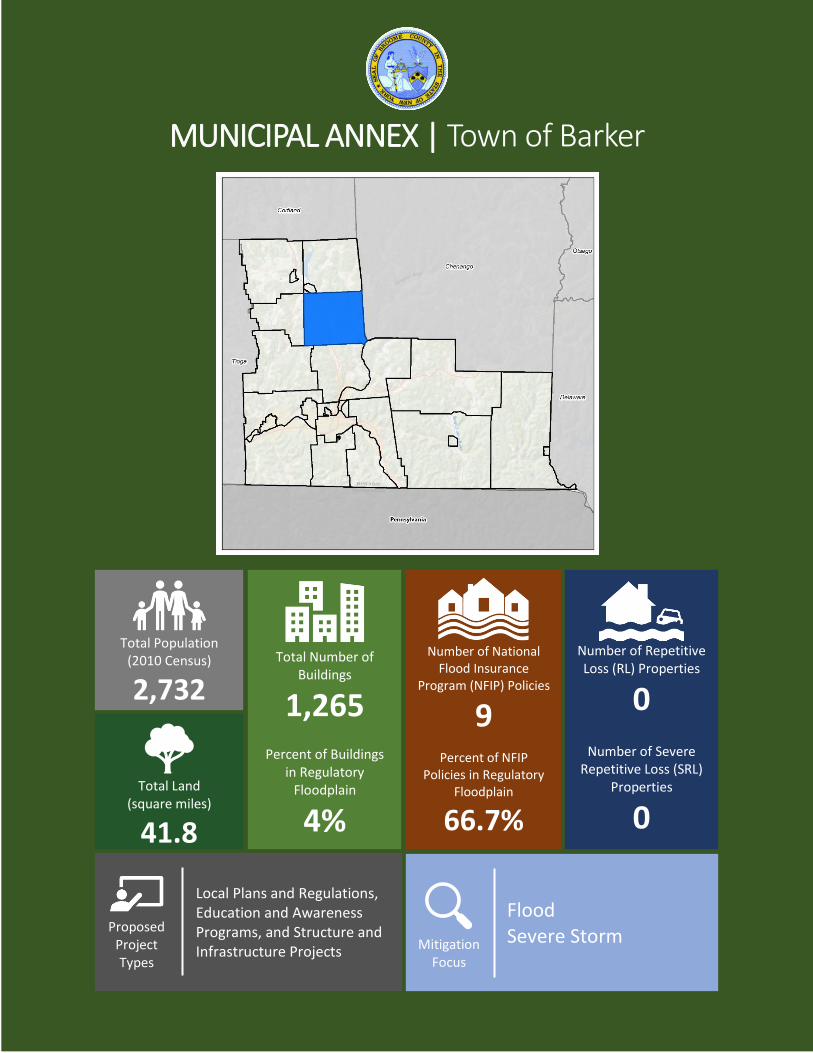
MUNICIPAL ANNEX | Town of Barker
Total Population
(2010 Census)
2,732
Number of National
Flood Insurance Program (NFIP) Policies
9
Percent of NFIP Policies in Regulatory
Floodplain
66.7%
Number of Repetitive Loss (RL) Properties
0
Number of Severe Repetitive Loss (SRL)
Properties
0
Local Plans and Regulations, Education and Awareness Programs, and Structure and Infrastructure Projects
Total Number of
Buildings
1,265
Percent of Buildings in Regulatory
Floodplain
4%
Proposed
Project Types
Flood Severe Storm
Mitigation Focus
Total Land
(square miles)
41.8
Section 9.2: Town of Barker
DMA 2000 Hazard Mitigation Plan Update –Broome County, New York 9.2-1 March 2019
9.2 Town of Barker
This section presents the jurisdictional annex for the Town of Barker. It includes resources and information to
assist public and private sectors to reduce losses from future hazard events. This annex is not guidance of what
to do when a disaster occurs. Rather, this annex concentrates on actions that can be implemented prior to a
disaster in order to reduce or eliminate damage to property and people. This annex includes a general overview
of the municipality and who in the Town participated in the planning process; an assessment of the Town of
Barker’s risk and vulnerability; the different capabilities utilized in the Town; and an action plan that will be
implemented to achieve a more resilient community.
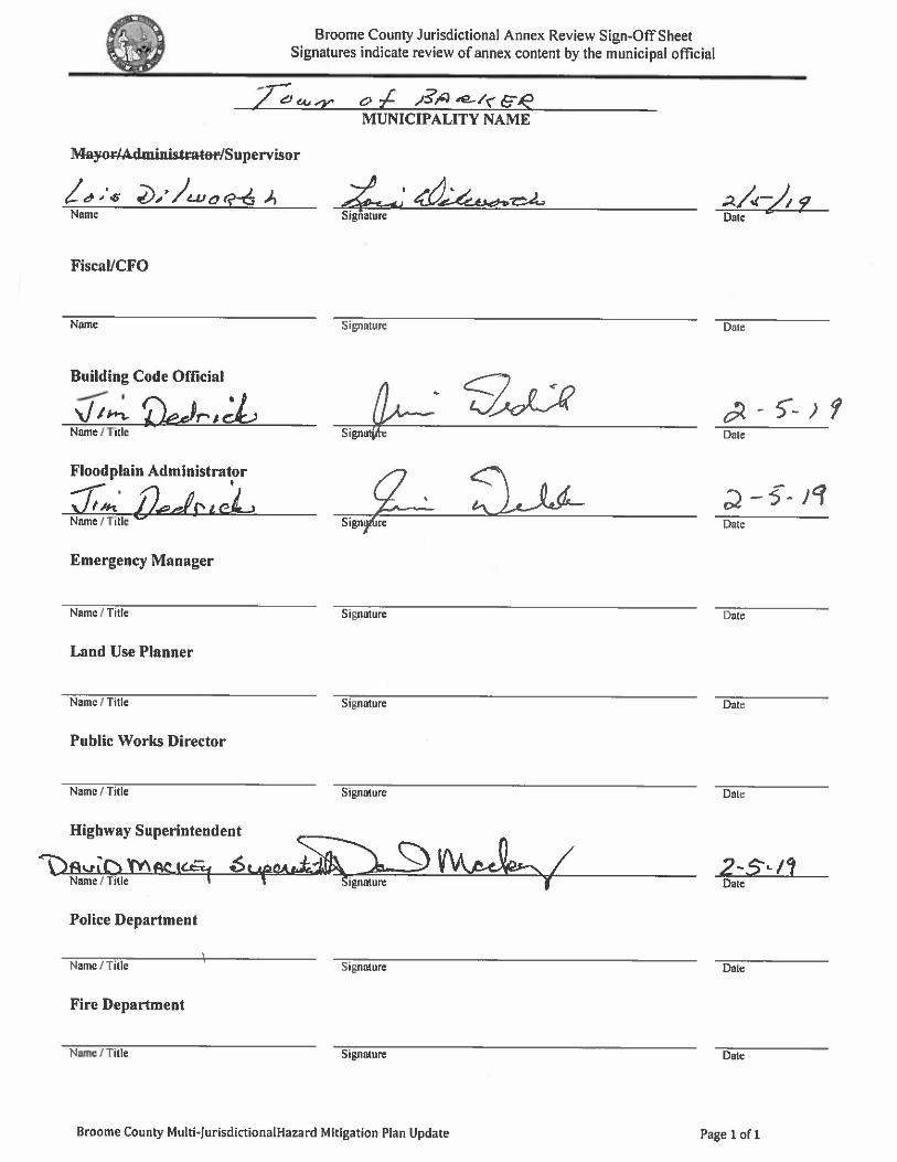
9.2.1 Hazard Mitigation Planning Team
The following individuals have been identified as the Town of Barker’s hazard mitigation plan primary and
alternate points of contact.
Primary Point of Contact Alternate Point of Contact
Name: David Mackey
Title: Highway Superintendent
Phone Number: 607-692-3990; 607-760-4739
Address: Route 79, Barker, NY
Email: [email protected]
Name: Jim Dedrick
Title: Code Enforcement/Building Inspector
Phone Number: 607-761-7385
Address: 151 Hyde Street, Barker, NY
Email: [email protected]
NFIP Floodplain Administrator
Name: Jim Dedrick
Title: Code Enforcement/Building Inspector
Phone Number: 607-761-7385
Address: 151 Hyde Street, Barker, NY
Email: [email protected]
9.2.2 Municipal Profile
The Town of Barker is on the east county line of Broome County and is north of Binghamton, NY. The Town
of Barker has a total area of 41.8 square miles. Interstate 81, U.S. Route 11, New York State Route 79, and the
Tioughnioga River pass through the town. The Town is bordered to the north by the Town of Triangle, on the
east by Chenango County, on the south by the Town of Fenton, Chenango and Maine, and on the west by the
Town of Nanticoke. According to the United States Census Bureau, the town has a total area of 41.8 square
mile (108 km2). The Town of Barker includes the hamlets of Chenango Forks, Hydeville, and Itaska. The
estimated 2016 population was 2,688 which a 1.6% decrease in population from 2010 (2,732 persons).
Home rule is strong in New York State and thus, each town and village has its own governing body. Towns are
made up of a Town Board and Supervisor. Villages generally have a Mayor, Clerk, and Council. Along with
town and village roads, any public water and sewer systems are operated by the local municipality, though they
may cooperate with County departments. Each municipality has charge over its own planning and zoning and
uses the County personnel as a resource.
Data from the 2016 U.S. Census American Community Survey estimates that 4.4% of the town population is
five years of age or younger, and 13.7% is 65 years of age or older.
History and Cultural Resources
The Town of Barker was formed on April 18, 1831 from what was then known as the “Old State of Lisle.”
The town was named after John Barker who took up a farm on the east of the Chenango River, which at the
Section 9.2: Town of Barker
DMA 2000 Hazard Mitigation Plan Update –Broome County, New York 9.2-2 March 2019
time was in the township of Chenango. When the new township was created, the town was named after him.
On April 28, 1940, a portion of the County of Chenango was added to the town.
Growth/Development Trends
Table 9.2-1 summarizes major residential/commercial development and any known or anticipated major
residential/commercial development and major infrastructure development that is likely to be occur within the
municipality in the next five years. Refer to the map in 9.2.9 of this annex which illustrates the hazard areas
along with the location of potential new development.
Table 9.2-1. Growth and Development
Property or Development Name
Type (e.g. Res., Comm.)
# of Units / Structures
Location (address and/or Parcel ID)
Known Hazard Zone(s)
Description/Status of Development
Recent Development from 2013 to present
No major Development
Known or Anticipated Development in the Next Five (5) Years
Senior Living
Center/Charlotte
Kenyon School
Commercial 40-50
units
Chenango Forks No Renovation of
School to senior
living center.
* Only location-specific hazard zones or vulnerabilities identified.
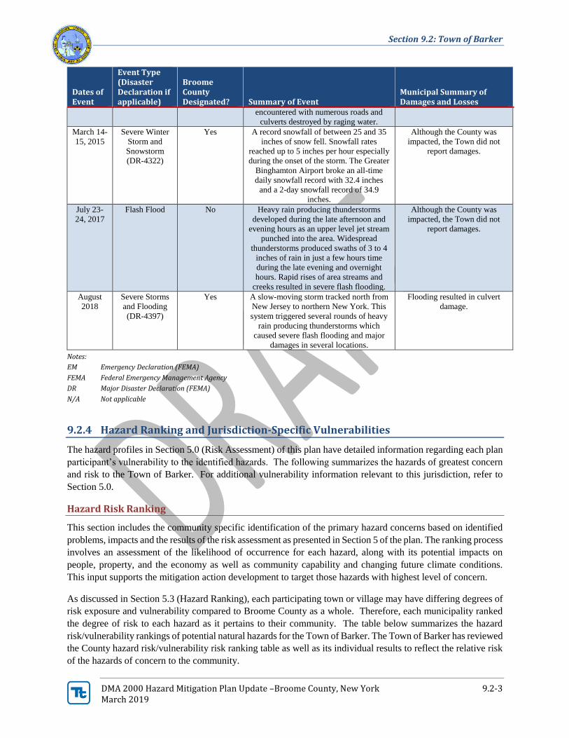
9.2.3 Hazard Event History Specific to the Town of Barker
Broome County has a history of natural events as detailed in Volume I, Section 5.0 of this plan. A summary of
historical events is provided in each of the hazard profiles and includes a chronology of events that have affected
the County and its municipalities. The Town of Barker’s history of federally-declared (as presented by FEMA)
and significant hazard events (as presented in NOAA-NCEI) is consistent with that of Broome County. Table
9.2-2 provides details regarding municipal-specific loss and damages the Town experienced during hazard
events. Information provided in the table below is based on reference material or local sources. For details of
these and additional events, refer to Volume I, Section 5.0 of this plan.
Table 9.2-2. Hazard Event History
Dates of Event
Event Type (Disaster Declaration if applicable)
Broome County Designated? Summary of Event
Municipal Summary of Damages and Losses
October
27-
November
8, 2012
Hurricane
Sandy (EM-
3351)
Yes The remnants of Hurricane Sandy moved
over the area bringing high winds and
precipitation
Yes, damages included road
washouts, closures, some
flooded basements
June 26-
July 10,
2013
Severe Storms
and Flooding
(DR-4219)
Yes The County was impacted by a series of
severe storms and flash flood events.
Although the County was
impacted, the Town did not
report damages.
June 14,
2015
Flash Flood No A warm front stalled across New York
and northern Pennsylvania, providing the
focus for repeating clusters of
thunderstorms in the Finger Lakes and
Southern Tier NY regions. A tropical-like
airmass was in place allowing for a stripe
of 2-4 inches of very heavy rain to fall in
a narrow band extending from near
Watkins Glen to areas north of
Binghamton. Severe flash flooding was
Although the County was
impacted, the Town did not
report damages.
Section 9.2: Town of Barker
DMA 2000 Hazard Mitigation Plan Update –Broome County, New York 9.2-3 March 2019
Dates of Event
Event Type (Disaster Declaration if applicable)
Broome County Designated? Summary of Event
Municipal Summary of Damages and Losses
encountered with numerous roads and
culverts destroyed by raging water.
March 14-
15, 2015
Severe Winter
Storm and
Snowstorm
(DR-4322)
Yes A record snowfall of between 25 and 35
inches of snow fell. Snowfall rates
reached up to 5 inches per hour especially
during the onset of the storm. The Greater
Binghamton Airport broke an all-time
daily snowfall record with 32.4 inches
and a 2-day snowfall record of 34.9
inches.
Although the County was
impacted, the Town did not
report damages.
July 23-
24, 2017
Flash Flood No Heavy rain producing thunderstorms
developed during the late afternoon and
evening hours as an upper level jet stream
punched into the area. Widespread
thunderstorms produced swaths of 3 to 4
inches of rain in just a few hours time
during the late evening and overnight
hours. Rapid rises of area streams and
creeks resulted in severe flash flooding.
Although the County was
impacted, the Town did not
report damages.
August
2018
Severe Storms
and Flooding
(DR-4397)
Yes A slow-moving storm tracked north from
New Jersey to northern New York. This
system triggered several rounds of heavy
rain producing thunderstorms which
caused severe flash flooding and major
damages in several locations.
Flooding resulted in culvert
damage.
Notes:
EM Emergency Declaration (FEMA)
FEMA Federal Emergency Management Agency
DR Major Disaster Declaration (FEMA)
N/A Not applicable
9.2.4 Hazard Ranking and Jurisdiction-Specific Vulnerabilities
The hazard profiles in Section 5.0 (Risk Assessment) of this plan have detailed information regarding each plan
participant’s vulnerability to the identified hazards. The following summarizes the hazards of greatest concern
and risk to the Town of Barker. For additional vulnerability information relevant to this jurisdiction, refer to
Section 5.0.
Hazard Risk Ranking
This section includes the community specific identification of the primary hazard concerns based on identified
problems, impacts and the results of the risk assessment as presented in Section 5 of the plan. The ranking process
involves an assessment of the likelihood of occurrence for each hazard, along with its potential impacts on
people, property, and the economy as well as community capability and changing future climate conditions.
This input supports the mitigation action development to target those hazards with highest level of concern.
As discussed in Section 5.3 (Hazard Ranking), each participating town or village may have differing degrees of
risk exposure and vulnerability compared to Broome County as a whole. Therefore, each municipality ranked
the degree of risk to each hazard as it pertains to their community. The table below summarizes the hazard
risk/vulnerability rankings of potential natural hazards for the Town of Barker. The Town of Barker has reviewed
the County hazard risk/vulnerability risk ranking table as well as its individual results to reflect the relative risk
of the hazards of concern to the community.
Section 9.2: Town of Barker
DMA 2000 Hazard Mitigation Plan Update –Broome County, New York 9.2-4 March 2019
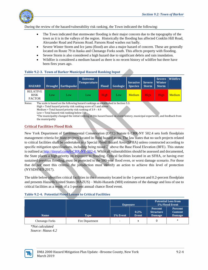
During the review of the hazard/vulnerability risk ranking, the Town indicated the following:
• The Town indicated that stormwater flooding is their major concern due to the topography of the
town as it is in the valleys of the region. Historically the flooding has affected Conklin Hill Road,
Alexander Road and Parsons Road. Parsons Road washes out badly.
• Severe Winter Storm and Ice jams (flood) are also a major hazard of concern. These are generally
located on Route 79 in Itaska and Chenango Forks south. This affects property with flooding.
• Severe Storm is also considered a high hazard due to significant debris and rain inundation.
• Wildfire is considered a medium hazard as there is no recent history of wildfire but there have
been fires years ago.
Table 9.2-3. Town of Barker Municipal Hazard Ranking Input
HAZARD Drought Earthquake
Extreme Temperature
Flood Geologic Invasive Species
Severe Storm
Severe Winter Storm
Wildfire
RELATIVE
RISK
FACTOR
Low Low Low High Low Medium High High Medium
Notes: The scale is based on the following hazard rankings as established in Section 5.3. High = Total hazard priority risk ranking score of 5 and above Medium = Total hazard priority risk ranking of 3.9 – 4.9 Low = Total hazard risk ranking below 3.8 *The municipality changed the initial ranking of this hazard based on event history, municipal experience, and feedback from the municipality
Critical Facilities Flood Risk
New York Department of Environmental Conservation (DEC) Statute 6 CRR-NY 502.4 sets forth floodplain
management criteria for State projects located in flood hazard areas. The law states that no such projects related
to critical facilities shall be undertaken in a Special Flood Hazard Area (SFHA) unless constructed according to
specific mitigation specifications, including being raised 2’ above the Base Flood Elevation (BFE). This statute
is outlined at http://tinyurl.com/6-CRR-NY-502-4. While all vulnerabilities should be assessed and documented,
the State places a high priority on exposure to flooding. Critical facilities located in an SFHA, or having ever
sustained previous flooding, must be protected to the 500-year flood even, or worst damage scenario. For those
that do not meet this criteria, the jurisdiction must identify an action to achieve this level of protection
(NYSDHSES 2017).
The table below identifies critical facilities in the community located in the 1-percent and 0.2-percent floodplain
and presents Hazards United States (HAZUS) – Multi-Hazards (MH) estimates of the damage and loss of use to
critical facilities as a result of a 1-percent annual chance flood event.
Table 9.2-4. Potential Flood Losses to Critical Facilities
Name Type
Exposure Potential Loss from
1% Flood Event
1% Event 0.2% Event
Percent Structure Damage
Percent Content Damage
Chenango Forks Fire Department - x 0 *
*Not calculated Source: Hazus 4.2
Section 9.2: Town of Barker
DMA 2000 Hazard Mitigation Plan Update –Broome County, New York 9.2-5 March 2019
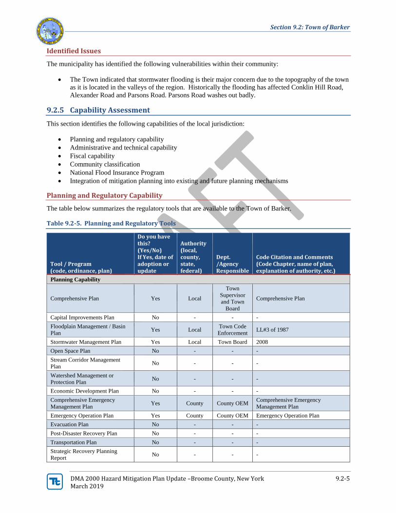
Identified Issues
The municipality has identified the following vulnerabilities within their community:
• The Town indicated that stormwater flooding is their major concern due to the topography of the town
as it is located in the valleys of the region. Historically the flooding has affected Conklin Hill Road,
Alexander Road and Parsons Road. Parsons Road washes out badly.
9.2.5 Capability Assessment
This section identifies the following capabilities of the local jurisdiction:
• Planning and regulatory capability
• Administrative and technical capability
• Fiscal capability
• Community classification
• National Flood Insurance Program
• Integration of mitigation planning into existing and future planning mechanisms
Planning and Regulatory Capability
The table below summarizes the regulatory tools that are available to the Town of Barker.
Table 9.2-5. Planning and Regulatory Tools
Tool / Program (code, ordinance, plan)
Do you have this? (Yes/No) If Yes, date of adoption or update
Authority (local, county, state, federal)
Dept. /Agency Responsible
Code Citation and Comments (Code Chapter, name of plan, explanation of authority, etc.)
Planning Capability
Comprehensive Plan Yes Local
Town
Supervisor
and Town
Board
Comprehensive Plan
Capital Improvements Plan No - - -
Floodplain Management / Basin
Plan Yes Local
Town Code
Enforcement LL#3 of 1987
Stormwater Management Plan Yes Local Town Board 2008
Open Space Plan No - - -
Stream Corridor Management
Plan No - - -
Watershed Management or
Protection Plan No - - -
Economic Development Plan No - - -
Comprehensive Emergency
Management Plan Yes County County OEM
Comprehensive Emergency
Management Plan
Emergency Operation Plan Yes County County OEM Emergency Operation Plan
Evacuation Plan No - - -
Post-Disaster Recovery Plan No - - -
Transportation Plan No - - -
Strategic Recovery Planning
Report No - - -
Section 9.2: Town of Barker
DMA 2000 Hazard Mitigation Plan Update –Broome County, New York 9.2-6 March 2019
Tool / Program (code, ordinance, plan)
Do you have this? (Yes/No) If Yes, date of adoption or update
Authority (local, county, state, federal)
Dept. /Agency Responsible
Code Citation and Comments (Code Chapter, name of plan, explanation of authority, etc.)
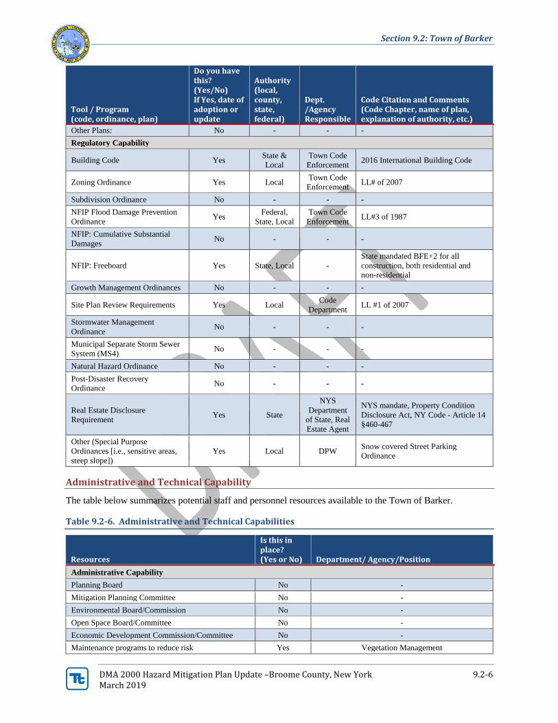
Other Plans: No - - -
Regulatory Capability
Building Code Yes State &
Local
Town Code
Enforcement 2016 International Building Code
Zoning Ordinance Yes Local Town Code
Enforcement LL# of 2007
Subdivision Ordinance No - - -
NFIP Flood Damage Prevention
Ordinance Yes
Federal,
State, Local
Town Code
Enforcement LL#3 of 1987
NFIP: Cumulative Substantial
Damages No - - -
NFIP: Freeboard Yes State, Local -
State mandated BFE+2 for all
construction, both residential and
non-residential
Growth Management Ordinances No - - -
Site Plan Review Requirements Yes Local Code
Department LL #1 of 2007
Stormwater Management
Ordinance No - - -
Municipal Separate Storm Sewer
System (MS4) No - - -
Natural Hazard Ordinance No - - -
Post-Disaster Recovery
Ordinance No - - -
Real Estate Disclosure
Requirement Yes State
NYS
Department
of State, Real
Estate Agent
NYS mandate, Property Condition
Disclosure Act, NY Code - Article 14
§460-467
Other (Special Purpose
Ordinances [i.e., sensitive areas,
steep slope])
Yes Local DPW Snow covered Street Parking
Ordinance
Administrative and Technical Capability
The table below summarizes potential staff and personnel resources available to the Town of Barker.
Table 9.2-6. Administrative and Technical Capabilities
Resources
Is this in place? (Yes or No) Department/ Agency/Position
Administrative Capability
Planning Board No -
Mitigation Planning Committee No -
Environmental Board/Commission No -
Open Space Board/Committee No -
Economic Development Commission/Committee No -
Maintenance programs to reduce risk Yes Vegetation Management
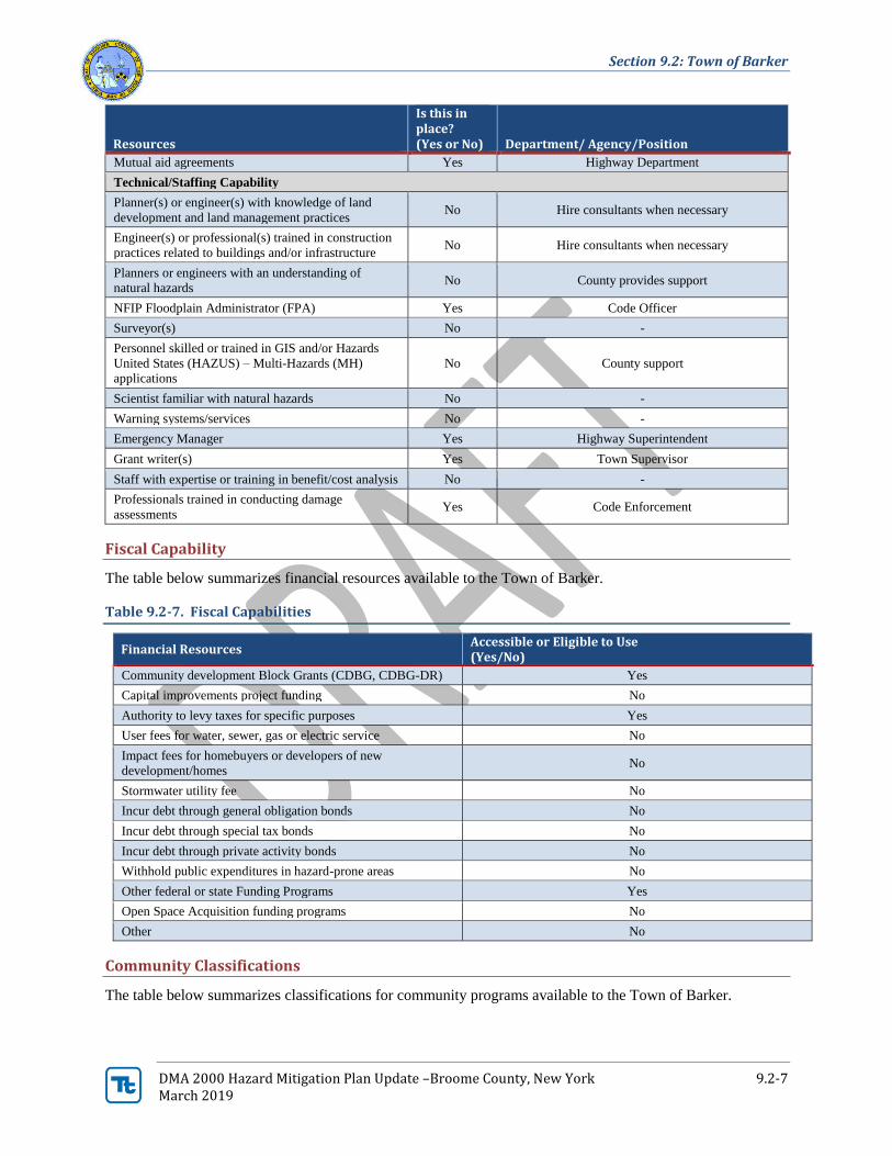
Section 9.2: Town of Barker
DMA 2000 Hazard Mitigation Plan Update –Broome County, New York 9.2-7 March 2019
Resources
Is this in place? (Yes or No) Department/ Agency/Position
Mutual aid agreements Yes Highway Department
Technical/Staffing Capability
Planner(s) or engineer(s) with knowledge of land
development and land management practices No Hire consultants when necessary
Engineer(s) or professional(s) trained in construction
practices related to buildings and/or infrastructure No Hire consultants when necessary
Planners or engineers with an understanding of
natural hazards No County provides support
NFIP Floodplain Administrator (FPA) Yes Code Officer
Surveyor(s) No -
Personnel skilled or trained in GIS and/or Hazards
United States (HAZUS) – Multi-Hazards (MH)
applications
No County support
Scientist familiar with natural hazards No -
Warning systems/services No -
Emergency Manager Yes Highway Superintendent
Grant writer(s) Yes Town Supervisor
Staff with expertise or training in benefit/cost analysis No -
Professionals trained in conducting damage
assessments Yes Code Enforcement
Fiscal Capability
The table below summarizes financial resources available to the Town of Barker.
Table 9.2-7. Fiscal Capabilities
Financial Resources Accessible or Eligible to Use (Yes/No)
Community development Block Grants (CDBG, CDBG-DR) Yes
Capital improvements project funding No
Authority to levy taxes for specific purposes Yes
User fees for water, sewer, gas or electric service No
Impact fees for homebuyers or developers of new
development/homes No
Stormwater utility fee No
Incur debt through general obligation bonds No
Incur debt through special tax bonds No
Incur debt through private activity bonds No
Withhold public expenditures in hazard-prone areas No
Other federal or state Funding Programs Yes
Open Space Acquisition funding programs No
Other No
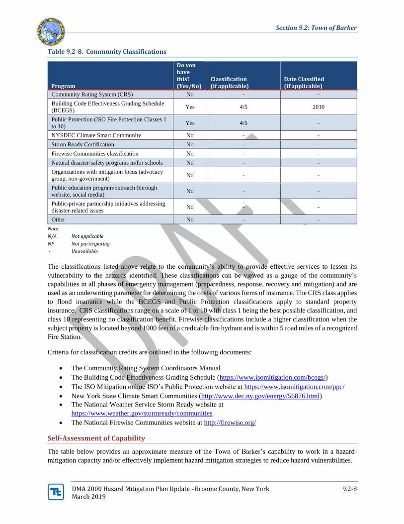
Community Classifications
The table below summarizes classifications for community programs available to the Town of Barker.
Section 9.2: Town of Barker
DMA 2000 Hazard Mitigation Plan Update –Broome County, New York 9.2-8 March 2019
Table 9.2-8. Community Classifications
Program
Do you have this? (Yes/No)
Classification (if applicable)
Date Classified (if applicable)
Community Rating System (CRS) No - -
Building Code Effectiveness Grading Schedule
(BCEGS) Yes 4/5 2010
Public Protection (ISO Fire Protection Classes 1
to 10) Yes 4/5 -
NYSDEC Climate Smart Community No - -
Storm Ready Certification No - -
Firewise Communities classification No - -
Natural disaster/safety programs in/for schools No - -
Organizations with mitigation focus (advocacy
group, non-government) No - -
Public education program/outreach (through
website, social media) No - -
Public-private partnership initiatives addressing
disaster-related issues No - -
Other No - -
Note:
N/A Not applicable
NP Not participating
- Unavailable
The classifications listed above relate to the community’s ability to provide effective services to lessen its
vulnerability to the hazards identified. These classifications can be viewed as a gauge of the community’s
capabilities in all phases of emergency management (preparedness, response, recovery and mitigation) and are
used as an underwriting parameter for determining the costs of various forms of insurance. The CRS class applies
to flood insurance while the BCEGS and Public Protection classifications apply to standard property
insurance. CRS classifications range on a scale of 1 to 10 with class 1 being the best possible classification, and
class 10 representing no classification benefit. Firewise classifications include a higher classification when the
subject property is located beyond 1000 feet of a creditable fire hydrant and is within 5 road miles of a recognized
Fire Station.
Criteria for classification credits are outlined in the following documents:
• The Community Rating System Coordinators Manual
• The Building Code Effectiveness Grading Schedule (https://www.isomitigation.com/bcegs/)
• The ISO Mitigation online ISO’s Public Protection website at https://www.isomitigation.com/ppc/
• New York State Climate Smart Communities (http://www.dec.ny.gov/energy/56876.html)
• The National Weather Service Storm Ready website at
https://www.weather.gov/stormready/communities
• The National Firewise Communities website at http://firewise.org/
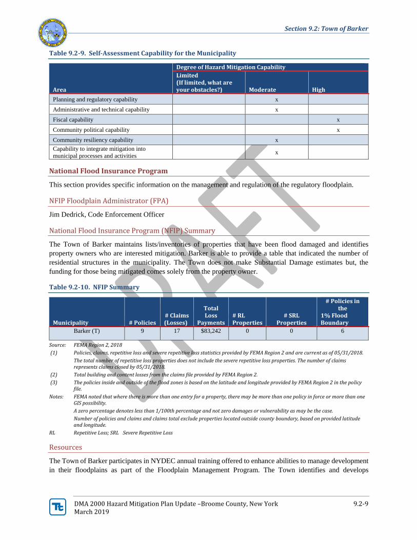
Self-Assessment of Capability
The table below provides an approximate measure of the Town of Barker’s capability to work in a hazard-
mitigation capacity and/or effectively implement hazard mitigation strategies to reduce hazard vulnerabilities.
Section 9.2: Town of Barker
DMA 2000 Hazard Mitigation Plan Update –Broome County, New York 9.2-9 March 2019
Table 9.2-9. Self-Assessment Capability for the Municipality
Area
Degree of Hazard Mitigation Capability
Limited (If limited, what are your obstacles?) Moderate High
Planning and regulatory capability x
Administrative and technical capability x
Fiscal capability x
Community political capability x
Community resiliency capability x
Capability to integrate mitigation into
municipal processes and activities x
National Flood Insurance Program
This section provides specific information on the management and regulation of the regulatory floodplain.
NFIP Floodplain Administrator (FPA)
Jim Dedrick, Code Enforcement Officer
National Flood Insurance Program (NFIP) Summary
The Town of Barker maintains lists/inventories of properties that have been flood damaged and identifies
property owners who are interested mitigation. Barker is able to provide a table that indicated the number of
residential structures in the municipality. The Town does not make Substantial Damage estimates but, the
funding for those being mitigated comes solely from the property owner.
Table 9.2-10. NFIP Summary
Municipality # Policies # Claims (Losses)
Total Loss
Payments # RL Properties
# SRL Properties
# Policies in the
1% Flood Boundary
Barker (T) 9 17 $83,242 0 0 6
Source: FEMA Region 2, 2018
(1) Policies, claims, repetitive loss and severe repetitive loss statistics provided by FEMA Region 2 and are current as of 05/31/2018.
The total number of repetitive loss properties does not include the severe repetitive loss properties. The number of claims represents claims closed by 05/31/2018.
(2) Total building and content losses from the claims file provided by FEMA Region 2.
(3) The policies inside and outside of the flood zones is based on the latitude and longitude provided by FEMA Region 2 in the policy file.
Notes: FEMA noted that where there is more than one entry for a property, there may be more than one policy in force or more than one GIS possibility.
A zero percentage denotes less than 1/100th percentage and not zero damages or vulnerability as may be the case.
Number of policies and claims and claims total exclude properties located outside county boundary, based on provided latitude and longitude.
RL Repetitive Loss; SRL Severe Repetitive Loss
Resources
The Town of Barker participates in NYDEC annual training offered to enhance abilities to manage development
in their floodplains as part of the Floodplain Management Program. The Town identifies and develops
Section 9.2: Town of Barker
DMA 2000 Hazard Mitigation Plan Update –Broome County, New York 9.2-10 March 2019
agreements with entities that can provide support with FEMA/SOEM paperwork after disasters, specifically to
conduct damage assessment; FEMA/SOEM paperwork compilation, submissions, record-keeping, etc.
Compliance History
The Town of Barker maintains compliance with and good-standing in the NFIP including adoption and
enforcement of floodplain management requirements (e.g. regulating all new and substantially improved
construction in Special Hazard Flood Areas), floodplain identification and mapping, and flood insurance
outreach to the community.
Regulatory
The Town obtains and archives elevation certificates. According to data from NYSDEC, the last community
audit (community assistance visit [CAV]) took place on March 4, 2008. The Town has considered joining the
Community Rating System (CRS) program in the past but has not decided to pursue participation.
Integration of Hazard Mitigation into Existing and Future Planning Mechanisms
For a community to succeed in reducing long-term risk, hazard mitigation must be integrated into the day-to-
day local government operations. As part of this planning effort, each community was surveyed to obtain a
better understanding of their community’s progress in plan integration. A summary is provided below. In
addition, the community identified specific integration activities that will be incorporated into municipal
procedures, which is also indicated below.
Planning
Existing Integration
Broome County Hazard Mitigation Plan: The Town of Barker supports the implementation, monitoring,
maintenance, and updating of this Plan, as defined in Section 7.0. The Town works to review existing local plans
and efforts to ensure consistency with this plan’s goals and objectives, and integrate the goals, objectives, and
activities from this plan into existing regulatory documents and programs, where appropriate (including zoning
ordinances, building codes, and land use policies).
Comprehensive Emergency Management Plans: The Town of Barker continually updates the Town’s
Comprehensive Emergency Management Plans.
Opportunities for Future Integration
Comprehensive Plan: During the update of the next municipal comprehensive plan, the town will incorporate
areas of hazard risk and discuss the Broome County Hazard Mitigation Plan.
Regulatory and Enforcement (Ordinances)
Existing Integration
Wind Resistant Construction: The Town Code official encourages development and enforcement of wind-
resistant building siding and construction codes with a focus placed on vulnerable residences first (i.e. mobile
homes).
Section 9.2: Town of Barker
DMA 2000 Hazard Mitigation Plan Update –Broome County, New York 9.2-11 March 2019
Operational and Administration
Existing Integration
Mutual Aid Agreements: The Town of Barker maintains and updates mutual aid agreements with the
surrounding communities.
Vegetation Management: The Town of Barker maintains and works to enhance programs to keep trees from
threatening lives, property, and public infrastructure during storm events. The Town also conducts maintenance
for roadside easements to prevent unsafe conditions (brush, grass, view obstructions and drainage obstructions).
Drainage Monitoring: The Town of Barker’s Department of Public Works, with the assistance of the County,
works to identify and address obstructions to surface water drainage.
Road Improvements: The Town of Barker’s Department of Public Works, with the assistance of the County,
monitors condition and maintains repair of town roads and road banks in high flood hazard areas.
Retrofitting/Removal of Structures from Hazard Prone Areas: Where appropriate, the Town of Barker
supports the retrofitting, purchase, or relocation of structures located in hazard-prone areas to protect structures
from future damage, with repetitive loss and severe repetitive loss properties as priority. The Town works to
identify facilities that are viable candidates for each strategy based on cost-effectiveness. Implementation of
these actions are based on available funding.
Structure/Facility Inventories/Datasets: The Town of Barker participates in regional, county and/or state level
projects and programs to develop improved structure and facility inventories and hazard datasets to support
enhanced risk assessment efforts. Such programs may include developing a detailed inventory of critical
facilities based upon FEMA’s Comprehensive Data Management System (CDMS) which could be used for
various planning and emergency management purposes including:
• Support the performance of enhanced risk and vulnerability assessments for hazards including flooding,
earthquake, wind, and land failure.
• Support state, county and local planning efforts including mitigation (including updates to the State
HMP), comprehensive emergency management, debris management, and land use.
Funding
Existing Integration
The town’s highway department budget has line items for routine maintenance and mitigation. This includes
snow removal, tree trimming, maintenance and upgrades of culverts and ditches.
Opportunities for Future Integration
The town will consider seeking FEMA mitigation funding to increase the resiliency of the community.
Education and Outreach
Existing Integration
The Town of Barker conducts and facilitates community and public education and outreach for residents and
businesses including, but not be limited to, the following to promote and effect natural hazard risk reduction:
• Provide and maintain links to the HMP website, and regularly post notices on the County/municipal
homepage(s) referencing the HMP webpages.
Section 9.2: Town of Barker
DMA 2000 Hazard Mitigation Plan Update –Broome County, New York 9.2-12 March 2019
• Prepare and distribute informational letters to flood vulnerable property owners and neighborhood
associations, explaining the availability of mitigation grant funding to mitigate their properties, and
instructing them on how they can learn more and implement mitigation.
• Use email notification systems and newsletters to better educate the public on flood insurance, the
availability of mitigation grant funding, and personal natural hazard risk reduction measures.
• Work with neighborhood associations, civic and business groups to disseminate information on flood
insurance and the availability of mitigation grant funding.
Opportunities for Future Integration
The Town of Barker currently does not have a municipal website. A municipal website could allow the Town
the opportunity to electronically conduct outreach and keep the public informed on mitigation actions as well as
be a location for information during hazard events.
Sheltering, Evacuation, and Temporary Housing
Temporary housing, evacuation routes, and sheltering measures must be in place and available for public
awareness to protect residents, mitigate risk, and relocate residents, if necessary, to maintain post-disaster social
and economic stability.
Temporary and Permanent Housing
At the time of the plan update, the Town of Barker does not have any sites suitable for temporary or permanent
housing locations. The Town is fully developed and does not have vacant land available for rebuilding of homes.
Evacuation and Sheltering Needs
The Town of Barker maintains evacuation plans, routes, policies and procedures for the full range of
contingencies and geographic areas of the jurisdiction. The Town continues to identify areas and specific
residents who would need evacuations assistance including residents who lack transportation. The Town
develops evacuation assistance plans for these residents.
The Town of Barker has identified the possibility of using the municipal fire department buildings and the
municipal highway department building as shelters. However, the shelters do not have proper provisions for
long-term sheltering of residents (no restrooms or showers, no kitchen facilities, etc.)
9.2.6 Mitigation Strategy and Prioritization
This section discusses past mitigations actions and status, describes proposed hazard mitigation initiatives, and
their prioritization.
Past Mitigation Initiative Status
The following table indicates progress on the community’s mitigation strategy identified in the 2013 Plan.
Actions that are carried forward as part of this plan update are included in the following subsection in its own
table with prioritization. Previous actions that are now on-going programs and capabilities are indicated as such
in the following table and may also be found under ‘Capability Assessment’ presented previously in this annex.
Section 9.2: Town of Barker
DMA 2000 Hazard Mitigation Plan Update – Broome County, New York 9.2-13 March 2019
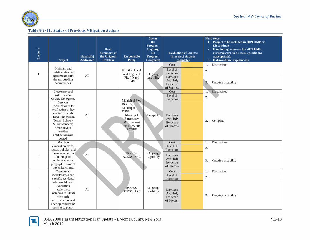
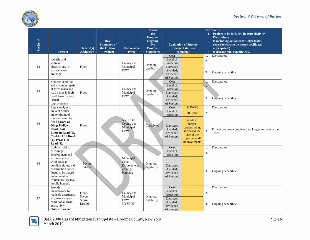
Table 9.2-11. Status of Previous Mitigation Actions
Pro
ject
#
Project
Hazard(s)
Addressed
Brief
Summary of
the Original
Problem
Responsible
Party
Status
(In
Progress,
Ongoing,
No
Progress,
Complete)
Evaluation of Success
(if project status is
complete)
Next Steps
1. Project to be included in 2019 HMP or
Discontinue
2. If including action in the 2019 HMP,
revise/reword to be more specific (as
appropriate).
3. If discontinue, explain why.
1
Maintain and
update mutual aid
agreements with
the surrounding
communities.
All
BCOES. Local
and Regional
FD, PD and EMS
Ongoing
capability
Cost 1. Discontinue
Level of Protection
2.
Damages
Avoided;
Evidence of Success
3. Ongoing capability
2
Create protocol
with Broome County Emergency
Services
Coordinator to for notification of key
elected officials
(Town Supervisor, Town Highway
Superintendent)
when severe weather
notifications are
posted.
All
Municipal EM/ BCOES,
Municipal
DPW Municipal
Emergency
Management
and DPW and
BCOES
Complete
Cost 1. Discontinue
Level of
Protection 2.
Damages
Avoided;
Evidence
of Success
3. Complete
3
Maintain
evacuation plans,
routes, policies, and procedures for the
full range of
contingencies and geographic areas of
the jurisdictions.
All BCOES/
BCDSS, ARC
Ongoing
Capability
Cost 1. Discontinue
Level of
Protection 2.
Damages
Avoided; Evidence
of Success
3. Ongoing capability
4
Continue to
identify areas and
specific residents
who would need
evacuation assistance,
including residents
who lack transportation, and
develop evacuation assistance plans.
All BCOES/
BCDSS, ARC
Ongoing
capability.
Cost 1. Discontinue
Level of Protection
2.
Damages
Avoided;
Evidence of Success
3. Ongoing capability

Section 9.2: Town of Barker
DMA 2000 Hazard Mitigation Plan Update – Broome County, New York 9.2-14 March 2019
Pro
ject
#
Project
Hazard(s)
Addressed
Brief
Summary of
the Original
Problem
Responsible
Party
Status
(In
Progress,
Ongoing,
No
Progress,
Complete)
Evaluation of Success
(if project status is
complete)
Next Steps
1. Project to be included in 2019 HMP or
Discontinue
2. If including action in the 2019 HMP,
revise/reword to be more specific (as
appropriate).
3. If discontinue, explain why.
5
Continue training in the National
Incident Command
System (ICS), under the National
Incident
Management System (NIMS).
Highway
Superintendent
has completed 100
– 700.
All
FEMA,
NYSOEM,
County,
Municipal EM
and ARC
Complete
Cost 1. Discontinue
Level of
Protection 2.
Damages
Avoided;
Evidence of Success
3. Complete
6
Maintain and enhance programs
to keep trees from
threatening lives, property, and
public
infrastructure
during storm
events.
All
NYSEG,
County and
Municipal DPW/
Ongoing
capability
Cost 1. Discontinue
Level of Protection
2.
Damages Avoided;
Evidence
of Success
3. Ongoing capability
7
Review existing local plans and
efforts to ensure
consistency with this plan’s goals
and objectives, and
integrate the goals, objectives, and
activities from this
plan into existing regulatory
documents and
programs, where appropriate
(including zoning
ordinances, building codes, and
land use policies).
All
Municipal
Planning and Zoning Depts,
BCPD,
NYSDEC
Ongoing
capability
Cost 1. Discontinue
Level of Protection
2.
Damages Avoided;
Evidence
of Success
3. Ongoing capability
8
Assist in the update
of flood plain (FIRM) maps –
Flood
BCDP/
NYSDEC, In progress
Cost 1. Include in 2019 plan.
Level of Protection
2.
Section 9.2: Town of Barker
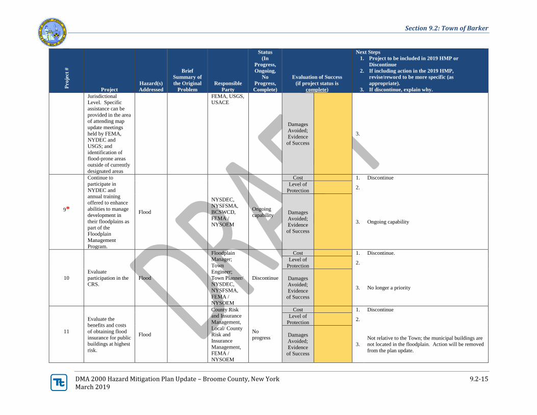
DMA 2000 Hazard Mitigation Plan Update – Broome County, New York 9.2-15 March 2019
Pro
ject
#
Project
Hazard(s)
Addressed
Brief
Summary of
the Original
Problem
Responsible
Party
Status
(In
Progress,
Ongoing,
No
Progress,
Complete)
Evaluation of Success
(if project status is
complete)
Next Steps
1. Project to be included in 2019 HMP or
Discontinue
2. If including action in the 2019 HMP,
revise/reword to be more specific (as
appropriate).
3. If discontinue, explain why.
Jurisdictional Level. Specific
assistance can be
provided in the area of attending map
update meetings
held by FEMA, NYDEC and
USGS; and
identification of flood-prone areas
outside of currently
designated areas
FEMA, USGS, USACE
Damages
Avoided;
Evidence
of Success
3.
9*
Continue to
participate in
NYDEC and annual training
offered to enhance
abilities to manage
development in
their floodplains as
part of the Floodplain
Management
Program.
Flood
NYSDEC, NYSFSMA,
BCSWCD,
FEMA / NYSOEM
Ongoing
capability
Cost 1. Discontinue
Level of
Protection 2.
Damages
Avoided; Evidence
of Success
3. Ongoing capability
10
Evaluate
participation in the
CRS.
Flood
Floodplain
Manager;
Town Engineer;
Town Planner/
NYSDEC, NYSFSMA,
FEMA /
NYSOEM
Discontinue
Cost 1. Discontinue.
Level of
Protection 2.
Damages
Avoided;
Evidence of Success
3. No longer a priority
11
Evaluate the benefits and costs
of obtaining flood
insurance for public buildings at highest
risk.
Flood
County Risk and Insurance
Management,
Local/ County Risk and
Insurance
Management, FEMA /
NYSOEM
No
progress
Cost 1. Discontinue
Level of
Protection 2.
Damages
Avoided;
Evidence of Success
3. Not relative to the Town; the municipal buildings are not located in the floodplain. Action will be removed
from the plan update.
Section 9.2: Town of Barker
DMA 2000 Hazard Mitigation Plan Update – Broome County, New York 9.2-16 March 2019
Pro
ject
#
Project
Hazard(s)
Addressed
Brief
Summary of
the Original
Problem
Responsible
Party
Status
(In
Progress,
Ongoing,
No
Progress,
Complete)
Evaluation of Success
(if project status is
complete)
Next Steps
1. Project to be included in 2019 HMP or
Discontinue
2. If including action in the 2019 HMP,
revise/reword to be more specific (as
appropriate).
3. If discontinue, explain why.
12
Identify and
address
obstructions to surface water
drainage
Flood
County and
Municipal DPW
Ongoing
capability
Cost 1. Discontinue
Level of
Protection 2.
Damages
Avoided;
Evidence
of Success
3. Ongoing capability
13
Monitor condition
and maintain repair of town roads and
road banks in high
flood hazard areas. –Road
Improvements.
Flood
County and
Municipal
DPW
Ongoing capability
Cost 1. Discontinue
Level of Protection
2.
Damages
Avoided; Evidence
of Success
3. Ongoing capability
14
Replace pipes to
prevent further undermining of
roads affected by flood hazard at
Dings Hollow
Road (2-4),
Ellerson Road (1),
Conklin Hill Road
(4), Pease Hill
Road (2).
Flood
NYSDOT,
County and
Municipal
DPW
Completed
Cost $150,000 1. Discontinue
Level of Protection
200-year 2.
Damages
Avoided;
Evidence of Success
Roads no
longer
undermining, increased the
size of the
pipes, overall improvements
3. Project has been completed; no longer an issue in the
Town
15
Code official to
encourage
development and enforcement of
wind-resistant
building siding and construction codes.
Focus to be placed
on vulnerable residences first (i.e.
mobile homes).
Severe
Storm
Municipal
Code
Enforcement, Zoning,
Planning
Ongoing
capability
Cost 1. Discontinue
Level of
Protection 2.
Damages Avoided;
Evidence
of Success
3. Ongoing capability
17
Provide
maintenance for roadside easements
to prevent unsafe
conditions (brush, grass, view
obstructions and
Flood,
Severe Storm,
Drought
County and
Municipal DPW,
NYSDOT
Ongoing capability
Cost 1. Discontinue
Level of Protection
2.
Damages
Avoided; Evidence
of Success
3. Ongoing capability
Section 9.2: Town of Barker
DMA 2000 Hazard Mitigation Plan Update – Broome County, New York 9.2-17 March 2019
Pro
ject
#
Project
Hazard(s)
Addressed
Brief
Summary of
the Original
Problem
Responsible
Party
Status
(In
Progress,
Ongoing,
No
Progress,
Complete)
Evaluation of Success
(if project status is
complete)
Next Steps
1. Project to be included in 2019 HMP or
Discontinue
2. If including action in the 2019 HMP,
revise/reword to be more specific (as
appropriate).
3. If discontinue, explain why.
drainage obstructions)
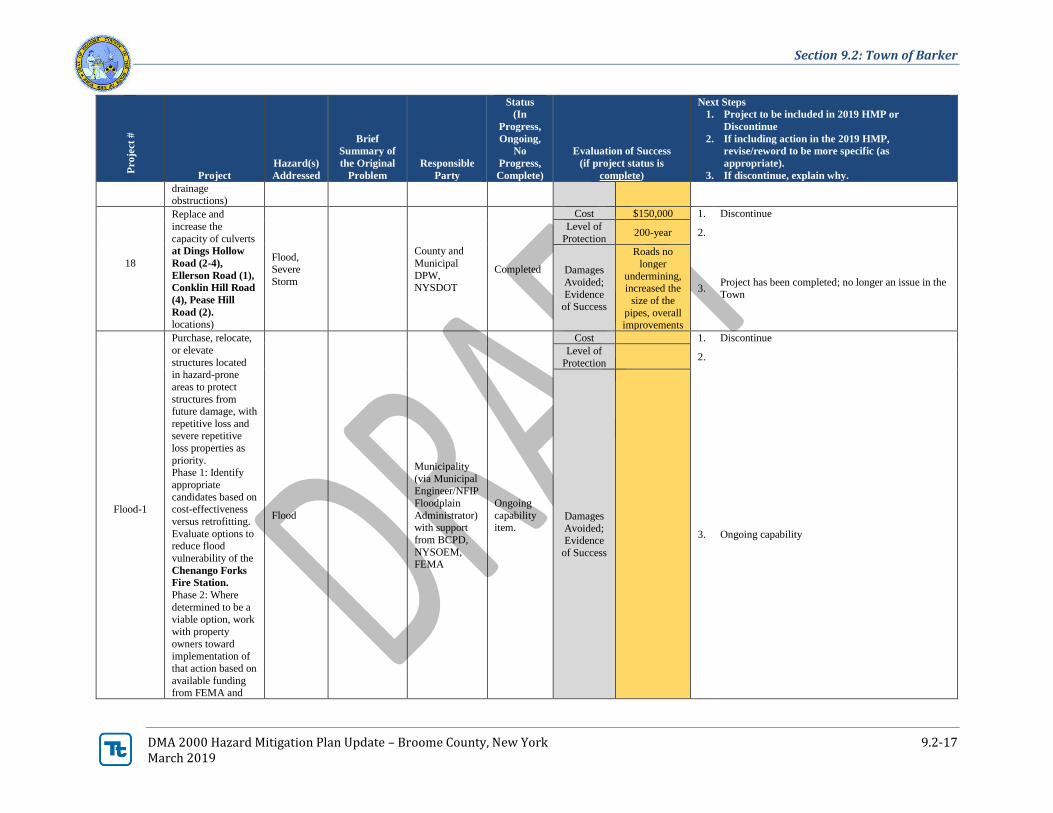
18
Replace and
increase the
capacity of culverts
at Dings Hollow
Road (2-4),
Ellerson Road (1),
Conklin Hill Road
(4), Pease Hill
Road (2). locations)
Flood, Severe
Storm
County and
Municipal
DPW, NYSDOT
Completed
Cost $150,000 1. Discontinue
Level of
Protection 200-year 2.
Damages
Avoided;
Evidence of Success
Roads no
longer
undermining, increased the
size of the
pipes, overall improvements
3. Project has been completed; no longer an issue in the
Town
Flood-1
Purchase, relocate,
or elevate
structures located in hazard-prone
areas to protect
structures from future damage, with
repetitive loss and severe repetitive
loss properties as
priority. Phase 1: Identify
appropriate
candidates based on cost-effectiveness
versus retrofitting.
Evaluate options to reduce flood
vulnerability of the
Chenango Forks
Fire Station.
Phase 2: Where
determined to be a viable option, work
with property
owners toward implementation of
that action based on
available funding from FEMA and
Flood
Municipality
(via Municipal Engineer/NFIP
Floodplain
Administrator) with support
from BCPD,
NYSOEM, FEMA
Ongoing
capability item.
Cost 1. Discontinue
Level of
Protection 2.
Damages
Avoided; Evidence
of Success
3. Ongoing capability
Section 9.2: Town of Barker
DMA 2000 Hazard Mitigation Plan Update – Broome County, New York 9.2-18 March 2019
Pro
ject
#
Project
Hazard(s)
Addressed
Brief
Summary of
the Original
Problem
Responsible
Party
Status
(In
Progress,
Ongoing,
No
Progress,
Complete)
Evaluation of Success
(if project status is
complete)
Next Steps
1. Project to be included in 2019 HMP or
Discontinue
2. If including action in the 2019 HMP,
revise/reword to be more specific (as
appropriate).
3. If discontinue, explain why.
local match availability.
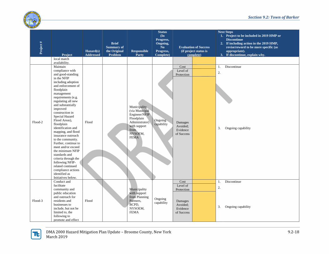
Flood-2
Maintain
compliance with and good-standing
in the NFIP
including adoption and enforcement of
floodplain
management requirements (e.g.
regulating all new
and substantially improved
construction in
Special Hazard Flood Areas),
floodplain
identification and
mapping, and flood
insurance outreach
to the community. Further, continue to
meet and/or exceed
the minimum NFIP standards and
criteria through the
following NFIP-related continued
compliance actions
identified as Initiatives below.
Flood
Municipality
(via Municipal Engineer/NFIP
Floodplain
Administrator) with support
from
NYSOEM, FEMA
Ongoing
capability
Cost 1. Discontinue
Level of
Protection 2.
Damages
Avoided; Evidence
of Success
3. Ongoing capability
Flood-3
Conduct and
facilitate community and
public education
and outreach for residents and
businesses to
include, but not be limited to, the
following to
promote and effect
Flood
Municipality
with support
from Planning Partners,
BCPD,
NYSOEM, FEMA
Ongoing
capability
Cost 1. Discontinue
Level of
Protection 2.
Damages Avoided;
Evidence
of Success
3. Ongoing capability
Section 9.2: Town of Barker
DMA 2000 Hazard Mitigation Plan Update – Broome County, New York 9.2-19 March 2019
Pro
ject
#
Project
Hazard(s)
Addressed
Brief
Summary of
the Original
Problem
Responsible
Party
Status
(In
Progress,
Ongoing,
No
Progress,
Complete)
Evaluation of Success
(if project status is
complete)
Next Steps
1. Project to be included in 2019 HMP or
Discontinue
2. If including action in the 2019 HMP,
revise/reword to be more specific (as
appropriate).
3. If discontinue, explain why.
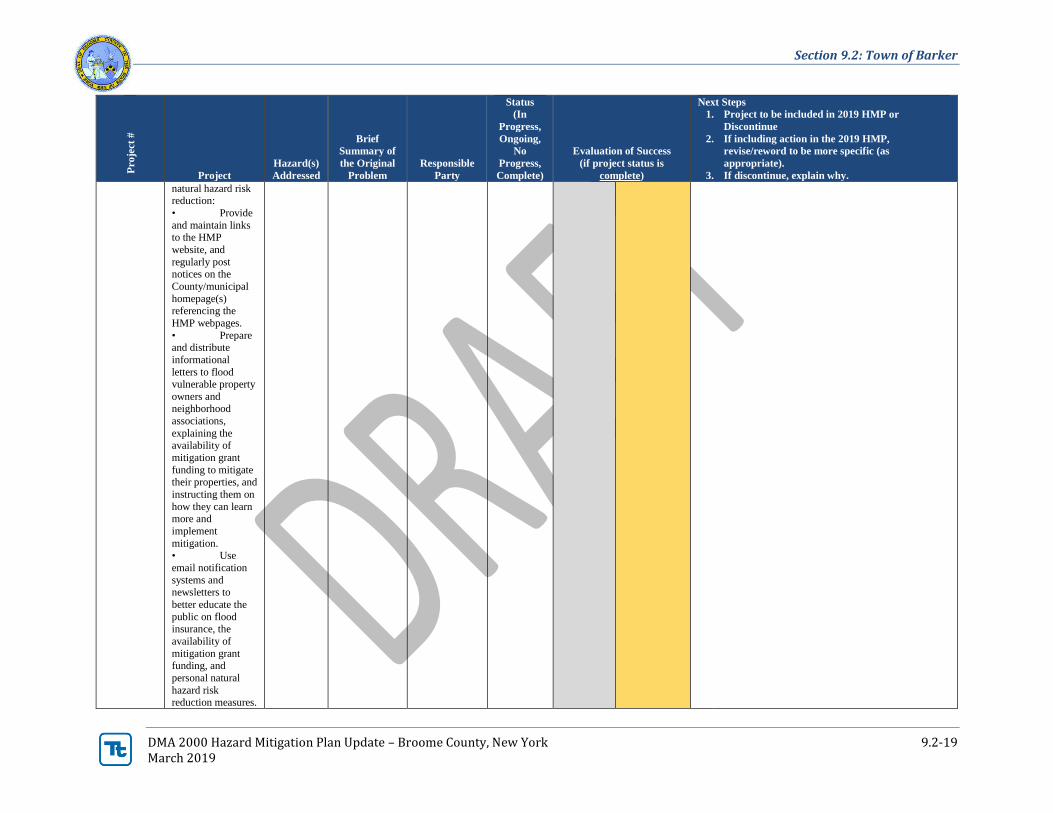
natural hazard risk reduction:
• Provide
and maintain links to the HMP
website, and
regularly post notices on the
County/municipal
homepage(s) referencing the
HMP webpages.
• Prepare and distribute
informational
letters to flood vulnerable property
owners and neighborhood
associations,
explaining the availability of
mitigation grant
funding to mitigate their properties, and
instructing them on
how they can learn more and
implement
mitigation. • Use
email notification
systems and newsletters to
better educate the
public on flood insurance, the
availability of
mitigation grant funding, and
personal natural
hazard risk reduction measures.
Section 9.2: Town of Barker
DMA 2000 Hazard Mitigation Plan Update – Broome County, New York 9.2-20 March 2019
Pro
ject
#
Project
Hazard(s)
Addressed
Brief
Summary of
the Original
Problem
Responsible
Party
Status
(In
Progress,
Ongoing,
No
Progress,
Complete)
Evaluation of Success
(if project status is
complete)
Next Steps
1. Project to be included in 2019 HMP or
Discontinue
2. If including action in the 2019 HMP,
revise/reword to be more specific (as
appropriate).
3. If discontinue, explain why.
Work with neighborhood
associations, civic
and business groups to
disseminate
information on flood insurance and
the availability of
mitigation grant funding.
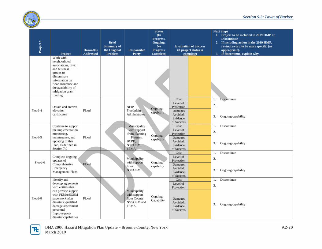
Flood-4 Obtain and archive elevation
certificates
Flood
NFIP Floodplain
Administrator
Ongoing
capability
Cost 1. Discontinue
Level of
Protection 2.
Damages
Avoided;
Evidence of Success
3. Ongoing capability
Flood-5
Continue to support
the implementation,
monitoring, maintenance, and
updating of this
Plan, as defined in Section 7.0
Flood
Municipality
with support
from Planning Partners,
BCPD,
NYSOEM, FEMA
Ongoing
capability
Cost 1. Discontinue
Level of
Protection 2.
Damages
Avoided;
Evidence of Success
3. Ongoing capability
Flood-6
Complete ongoing
updates of Comprehensive
Emergency
Management Plans
Flood
Municipality
with support
from NYSOEM
Ongoing
capability
Cost 1. Discontinue
Level of
Protection 2.
Damages Avoided;
Evidence
of Success
3. Ongoing capability
Flood-8
Identify and
develop agreements
with entities that can provide support
with FEMA/SOEM
paperwork after disasters; qualified
damage assessment
personnel – Improve post-
disaster capabilities
Flood
Municipality
with support
from County, NYSOEM and
FEMA
Ongoing
Capability
Cost 1. Discontinue
Level of
Protection 2.
Damages
Avoided; Evidence
of Success
3. Ongoing capability
Section 9.2: Town of Barker
DMA 2000 Hazard Mitigation Plan Update – Broome County, New York 9.2-21 March 2019
Pro
ject
#
Project
Hazard(s)
Addressed
Brief
Summary of
the Original
Problem
Responsible
Party
Status
(In
Progress,
Ongoing,
No
Progress,
Complete)
Evaluation of Success
(if project status is
complete)
Next Steps
1. Project to be included in 2019 HMP or
Discontinue
2. If including action in the 2019 HMP,
revise/reword to be more specific (as
appropriate).
3. If discontinue, explain why.
– damage assessment;
FEMA/SOEM
paperwork compilation,
submissions,
record-keeping
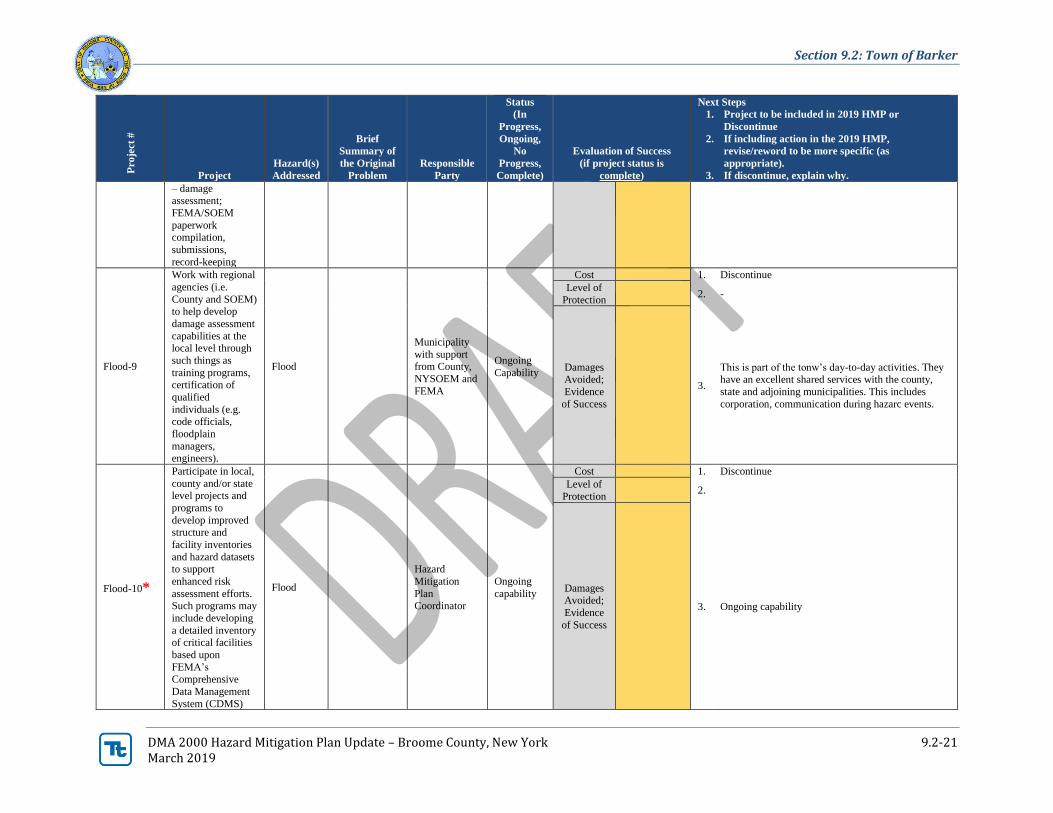
Flood-9
Work with regional
agencies (i.e.
County and SOEM) to help develop
damage assessment
capabilities at the local level through
such things as
training programs, certification of
qualified
individuals (e.g.
code officials,
floodplain
managers, engineers).
Flood
Municipality
with support from County,
NYSOEM and
FEMA
Ongoing
Capability
Cost 1. Discontinue
Level of
Protection 2. -
Damages Avoided;
Evidence
of Success
3.
This is part of the tonw’s day-to-day activities. They have an excellent shared services with the county,
state and adjoining municipalities. This includes
corporation, communication during hazarc events.
Flood-10*
Participate in local,
county and/or state level projects and
programs to
develop improved structure and
facility inventories
and hazard datasets to support
enhanced risk
assessment efforts. Such programs may
include developing
a detailed inventory of critical facilities
based upon
FEMA’s Comprehensive
Data Management
System (CDMS)
Flood
Hazard
Mitigation
Plan Coordinator
Ongoing
capability
Cost 1. Discontinue
Level of
Protection 2.
Damages
Avoided;
Evidence
of Success
3. Ongoing capability
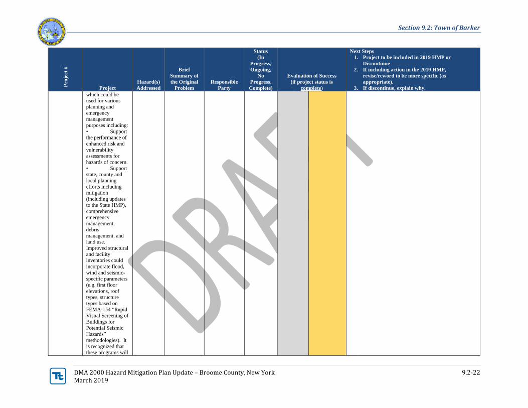
Section 9.2: Town of Barker
DMA 2000 Hazard Mitigation Plan Update – Broome County, New York 9.2-22 March 2019
Pro
ject
#
Project
Hazard(s)
Addressed
Brief
Summary of
the Original
Problem
Responsible
Party
Status
(In
Progress,
Ongoing,
No
Progress,
Complete)
Evaluation of Success
(if project status is
complete)
Next Steps
1. Project to be included in 2019 HMP or
Discontinue
2. If including action in the 2019 HMP,
revise/reword to be more specific (as
appropriate).
3. If discontinue, explain why.
which could be used for various
planning and
emergency management
purposes including:
• Support the performance of
enhanced risk and
vulnerability assessments for
hazards of concern.
• Support state, county and
local planning
efforts including mitigation
(including updates to the State HMP),
comprehensive
emergency management,
debris
management, and land use.
Improved structural
and facility inventories could
incorporate flood,
wind and seismic-specific parameters
(e.g. first floor
elevations, roof types, structure
types based on
FEMA-154 “Rapid Visual Screening of
Buildings for
Potential Seismic Hazards”
methodologies). It
is recognized that these programs will
Section 9.2: Town of Barker
DMA 2000 Hazard Mitigation Plan Update – Broome County, New York 9.2-23 March 2019
Pro
ject
#
Project
Hazard(s)
Addressed
Brief
Summary of
the Original
Problem
Responsible
Party
Status
(In
Progress,
Ongoing,
No
Progress,
Complete)
Evaluation of Success
(if project status is
complete)
Next Steps
1. Project to be included in 2019 HMP or
Discontinue
2. If including action in the 2019 HMP,
revise/reword to be more specific (as
appropriate).
3. If discontinue, explain why.
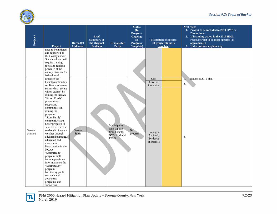
need to be initiated and supported at
the County and/or
State level, and will require training,
tools and funding
provided at the county, state and/or
federal level.
Severe
Storm-1
Enhance the County/community
resilience to severe
storms (incl. severe winter storms) by
joining the NOAA
“Storm Ready” program and
supporting
communities in
joining the
program.
"StormReady" communities are
better prepared to
save lives from the onslaught of severe
weather through
advanced planning, education and
awareness.
Participation in the NOAA
"StormReady"
program shall
include providing
information on the
“StormReady” program,
facilitating public
outreach and awareness
programs, and
supporting
Severe
Storm
Municipality
with support
from County, NYSOEM and
FEMA
No
progress
Cost 1. Include in 2019 plan.
Level of Protection
2.
Damages Avoided;
Evidence
of Success
3.
Section 9.2: Town of Barker
DMA 2000 Hazard Mitigation Plan Update – Broome County, New York 9.2-24 March 2019
Pro
ject
#
Project
Hazard(s)
Addressed
Brief
Summary of
the Original
Problem
Responsible
Party
Status
(In
Progress,
Ongoing,
No
Progress,
Complete)
Evaluation of Success
(if project status is
complete)
Next Steps
1. Project to be included in 2019 HMP or
Discontinue
2. If including action in the 2019 HMP,
revise/reword to be more specific (as
appropriate).
3. If discontinue, explain why.
community storm risk reduction
activities as
appropriate. Specific actions
addressed by
"StormReady" participation
include establishing
a 24 hour Warning Point, increase
number of ways
EOC receives NWS warnings, increase
number of ways to
disseminate warnings,
monitoring hydrometerological
data, providing
annual weather safety talks, train
weather spotters,
create a formal hazardous weather
plan, host annual
visits by NWS to communities, etc.
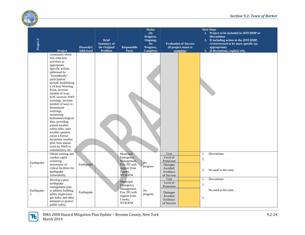
Earthquake-
1
Obtain training and
conduct rapid
screening assessment of
critical facilities for
earthquake vulnerability.
Earthquake
Municipal
Emergency
Management, Fire, PD with
support from
County, NYSOEM
No
progress
Cost 1. Discontinue.
Level of
Protection 2.
Damages Avoided;
Evidence
of Success
3. No need at this time.
Earthquake-
2
Develop a post-
earthquake management plan
to address building
safety inspections, gas leaks, and other
elements to protect
public safety.
Earthquake
Municipal
Emergency
Management, Fire, PD with
support from
County, NYSOEM
No
progress
Cost 1. Discontinue.
Level of
Protection 2.
Damages
Avoided;
Evidence of Success
3.
No need at this time.
Section 9.2: Town of Barker
DMA 2000 Hazard Mitigation Plan Update – Broome County, New York 9.2-25 March 2019
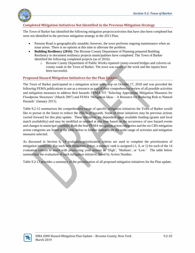
Completed Mitigation Initiatives Not Identified in the Previous Mitigation Strategy
The Town of Barker has identified the following mitigation projects/activities that have also been completed but
were not identified in the previous mitigation strategy in the 2013 Plan:
• Parsons Road is geographically unstable; however, the town performs ongoing maintenance when an
issue arises. There is no options at this time to alleviate the problem.
• Building Resiliency (2016): The Broome County Department of Planning prepared Building
Resiliency to document resiliency projects municipalities have completed. The Town of Barker
identified the following completed projects (as of 2016):
o Broome County Department of Public Works repaired county-owned bridges and culverts on
county roads in the Town of Barker. The town was aware of the work and the repairs have
been successful.
Proposed Hazard Mitigation Initiatives for the Plan Update
The Town of Barker participated in a mitigation action workshop on October 17, 2018 and was provided the
following FEMA publications to use as a resource as part of their comprehensive review of all possible activities
and mitigation measures to address their hazards: FEMA 551 ‘Selecting Appropriate Mitigation Measures for
Floodprone Structures’ (March 2007) and FEMA ‘Mitigation Ideas – A Resource for Reducing Risk to Natural
Hazards’ (January 2013).
Table 9.2-12 summarizes the comprehensive-range of specific mitigation initiatives the Town of Barker would
like to pursue in the future to reduce the effects of hazards. Some of these initiatives may be previous actions
carried forward for this plan update. These initiatives are dependent upon available funding (grants and local
match availability) and may be modified or omitted at any time based on the occurrence of new hazard events
and changes in municipal priorities. Both the four FEMA mitigation action categories and the six CRS mitigation
action categories are listed in the table below to further demonstrate the wide-range of activities and mitigation
measures selected.
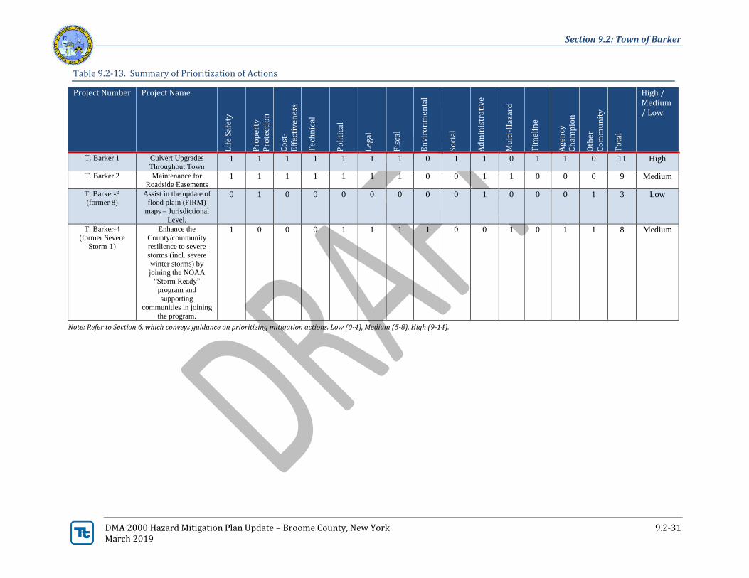
As discussed in Section 6, 14 evaluation/prioritization criteria are used to complete the prioritization of
mitigation initiatives. For each new mitigation action, a numeric rank is assigned (-1, 0, or 1) for each of the 14
evaluation criteria to assist with prioritizing your actions as ‘High’, ‘Medium’, or ‘Low.’ The table below
summarizes the evaluation of each mitigation initiative, listed by Action Number.
Table 9.2-13 provides a summary of the prioritization of all proposed mitigation initiatives for the Plan update.
Section 9.2: Town of Barker
DMA 2000 Hazard Mitigation Plan Update – Broome County, New York 9.2-26 March 2019
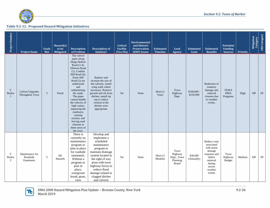
Table 9.2-12. Proposed Hazard Mitigation Initiatives
Pro
ject
Nu
mb
er
Project Name Goals Met
Hazard(s) to be
Mitigated Description of Problem
Description of Solution?
Critical Facility
(Yes/No)
Environmental and Historic Preservation (EHP) Issues
Estimated Timeline
Lead Agency
Estimated Costs
Estimated Benefits
Potential Funding Sources Priority
Mit
iga
tio
n
Ca
teg
ory
CR
S C
ate
go
ry
T. Barker
1
Culvert Upgrades
Throughout Town 5 Flood
The culvert
pipes along
Dings Hollow
Road (2-4),
Ellerson Road
(1), Conklin Hill Road (4),
Pease Hill
Road (2) are undersized
and
undermining the roads.
The pipes
cannot handle the velocity of
high waters,
impacting the roadways,
causing erosion, and
forcing road
closures in these areas of
the town.
Replace and
increase the size of the culverts, install
wing walls where
necessary. Remove growth and silt from
ditches, install rip
rap to reduce erosion in the
ditches were
appropriate.
No None Short (1
Year)
Town Highway
Dept.
$100,000 -
$150,000
Reduction of
roadway
damage and reduced
closures due
to weather events.
FEMA HMA
Programs
High SIP SP
T. Barker
2
Maintenance for Roadside
Easements
5 All-
Hazards
There is
currently no
maintenance
program or
plan in place
for roadside
easements.
Without a
program or
plan in
place,
overgrown
brush, grass,
view
Develop and
implement a
scheduled
maintenance
program to
maintain drainage
system located in
the right of way
areas with town
highway forces to
reduce flood
damage related to
clogged ditches
and culverts
No None Short (3
Months)
Town
Highway Dept., Town
Planning
Board
$30,000
(Annually)
Reduce costs
associated with storm
damage
response and debris
removal
during severe
weather
events
Town Highway
Budget
Medium SIP SP
Section 9.2: Town of Barker
DMA 2000 Hazard Mitigation Plan Update – Broome County, New York 9.2-27 March 2019
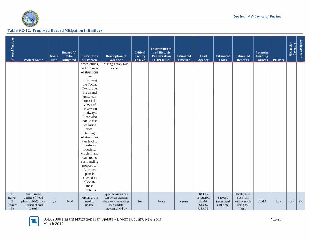
Table 9.2-12. Proposed Hazard Mitigation Initiatives
Pro
ject
Nu
mb
er
Project Name Goals Met
Hazard(s) to be
Mitigated Description of Problem
Description of Solution?
Critical Facility
(Yes/No)
Environmental and Historic Preservation (EHP) Issues
Estimated Timeline
Lead Agency
Estimated Costs
Estimated Benefits
Potential Funding Sources Priority
Mit
iga
tio
n
Ca
teg
ory
CR
S C
ate
go
ry
obstructions,
and drainage
obstructions
are
impacting
the Town.
Overgrown
brush and
grass can
impact the
views of
drivers on
roadways.
It can also
lead to fuel
for brush
fires.
Drainage
obstructions
can lead to
roadway
flooding,
erosion, and
damage to
surrounding
properties.
A proper
plan is
needed to
alleviate
these
problems.
during heavy rain
events.
T.
Barker 3
(former
8)
Assist in the
update of flood plain (FIRM) maps
– Jurisdictional
Level.
1, 2 Flood FIRMs are in
need of
update.
Specific assistance
can be provided in the area of attending
map update
meetings held by
No None 5 years
BCDP/
NYSDEC, FEMA,
USGS,
USACE
$10,000 (municipal
staff time)
Development
decisions will be made
using the
best
FEMA Low LPR PR
Section 9.2: Town of Barker
DMA 2000 Hazard Mitigation Plan Update – Broome County, New York 9.2-28 March 2019
Table 9.2-12. Proposed Hazard Mitigation Initiatives
Pro
ject
Nu
mb
er
Project Name Goals Met
Hazard(s) to be
Mitigated Description of Problem
Description of Solution?
Critical Facility
(Yes/No)
Environmental and Historic Preservation (EHP) Issues
Estimated Timeline
Lead Agency
Estimated Costs
Estimated Benefits
Potential Funding Sources Priority
Mit
iga
tio
n
Ca
teg
ory
CR
S C
ate
go
ry
FEMA, NYDEC
and USGS; and identification of
flood-prone areas
outside of currently designated areas
available
data on floodplain
extent and
flood elevations.
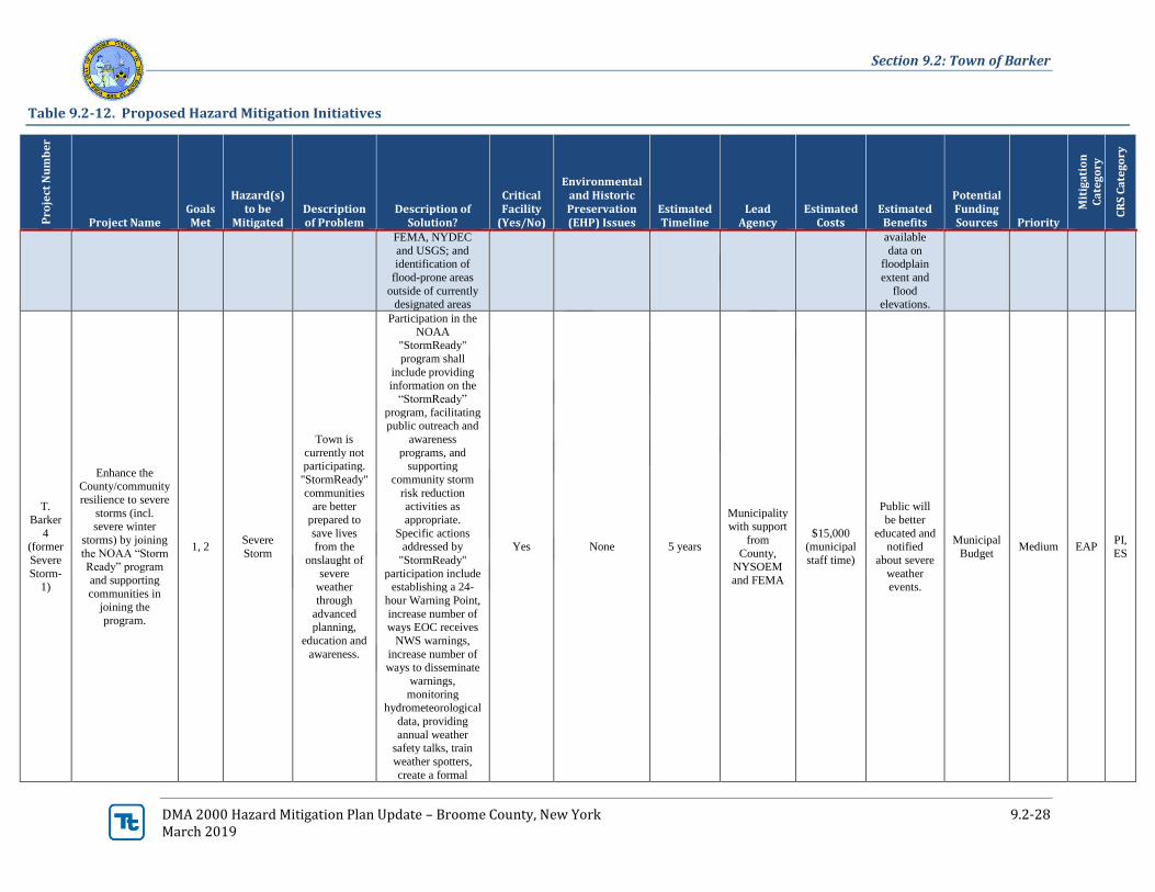
T.
Barker
4 (former
Severe
Storm-1)
Enhance the County/community
resilience to severe
storms (incl. severe winter
storms) by joining
the NOAA “Storm Ready” program
and supporting
communities in joining the
program.
1, 2 Severe
Storm
Town is
currently not
participating.
"StormReady"
communities are better
prepared to
save lives from the
onslaught of
severe weather
through
advanced planning,
education and
awareness.
Participation in the
NOAA "StormReady"
program shall
include providing information on the
“StormReady”
program, facilitating public outreach and
awareness
programs, and
supporting
community storm
risk reduction activities as
appropriate.
Specific actions addressed by
"StormReady"
participation include establishing a 24-
hour Warning Point,
increase number of ways EOC receives
NWS warnings,
increase number of ways to disseminate
warnings,
monitoring hydrometeorological
data, providing
annual weather safety talks, train
weather spotters,
create a formal
Yes None 5 years
Municipality with support
from
County, NYSOEM
and FEMA
$15,000 (municipal
staff time)
Public will
be better
educated and notified
about severe
weather events.
Municipal
Budget Medium EAP
PI,
ES
Section 9.2: Town of Barker
DMA 2000 Hazard Mitigation Plan Update – Broome County, New York 9.2-29 March 2019
Table 9.2-12. Proposed Hazard Mitigation Initiatives
Pro
ject
Nu
mb
er
Project Name Goals Met
Hazard(s) to be
Mitigated Description of Problem
Description of Solution?
Critical Facility
(Yes/No)
Environmental and Historic Preservation (EHP) Issues
Estimated Timeline
Lead Agency
Estimated Costs
Estimated Benefits
Potential Funding Sources Priority
Mit
iga
tio
n
Ca
teg
ory
CR
S C
ate
go
ry
hazardous weather
plan, host annual visits by NWS to
communities, etc.
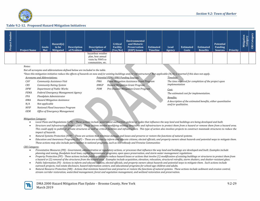
Notes:
Not all acronyms and abbreviations defined below are included in the table.
*Does this mitigation initiative reduce the effects of hazards on new and/or existing buildings and/or infrastructure? Not applicable (N/A) is inserted if this does not apply.
Acronyms and Abbreviations: Potential FEMA HMA Funding Sources: Timeline:
CAV Community Assistance Visit
CRS Community Rating System
DPW Department of Public Works
FEMA Federal Emergency Management Agency
FPA Floodplain Administrator
HMA Hazard Mitigation Assistance
N/A Not applicable
NFIP National Flood Insurance Program
OEM Office of Emergency Management
FMA Flood Mitigation Assistance Grant Program
HMGP Hazard Mitigation Grant Program
PDM Pre-Disaster Mitigation Grant Program
The time required for completion of the project upon implementation
Cost:
The estimated cost for implementation.
Benefits:
A description of the estimated benefits, either quantitative and/or qualitative.
Mitigation Category: • Local Plans and Regulations (LPR) – These actions include government authorities, policies or codes that influence the way land and buildings are being developed and built.
• Structure and Infrastructure Project (SIP) - These actions involve modifying existing structures and infrastructure to protect them from a hazard or remove them from a hazard area.
This could apply to public or private structures as well as critical facilities and infrastructure. This type of action also involves projects to construct manmade structures to reduce the
impact of hazards.
• Natural Systems Protection (NSP) – These are actions that minimize damage and losses and preserve or restore the functions of natural systems.
• Education and Awareness Programs (EAP) – These are actions to inform and educate citizens, elected officials, and property owners about hazards and potential ways to mitigate them.
These actions may also include participation in national programs, such as StormReady and Firewise Communities
CRS Category: • Preventative Measures (PR) - Government, administrative or regulatory actions, or processes that influence the way land and buildings are developed and built. Examples include
planning and zoning, floodplain local laws, capital improvement programs, open space preservation, and storm water management regulations. • Property Protection (PP) - These actions include public activities to reduce hazard losses or actions that involve (1) modification of existing buildings or structures to protect them from
a hazard or (2) removal of the structures from the hazard area. Examples include acquisition, elevation, relocation, structural retrofits, storm shutters, and shatter-resistant glass. • Public Information (PI) - Actions to inform and educate citizens, elected officials, and property owners about hazards and potential ways to mitigate them. Such actions include
outreach projects, real estate disclosure, hazard information centers, and educational programs for school-age children and adults. • Natural Resource Protection (NR) - Actions that minimize hazard loss and preserve or restore the functions of natural systems. These actions include sediment and erosion control,
stream corridor restoration, watershed management, forest and vegetation management, and wetland restoration and preservation.
Section 9.2: Town of Barker
DMA 2000 Hazard Mitigation Plan Update – Broome County, New York 9.2-30 March 2019
• Structural Flood Control Projects (SP) - Actions that involve the construction of structures to reduce the impact of a hazard. Such structures include dams, setback levees, floodwalls, retaining walls, and safe rooms.
• Emergency Services (ES) - Actions that protect people and property during and immediately following a disaster or hazard event. Services include warning systems, emergency response services, and the protection of essential facilities
Section 9.2: Town of Barker
DMA 2000 Hazard Mitigation Plan Update – Broome County, New York 9.2-31 March 2019
Table 9.2-13. Summary of Prioritization of Actions
Project Number Project Name
Lif
e Sa
fety
Pro
per
ty
Pro
tect
ion
Co
st-
Eff
ecti
ven
ess
Tec
hn
ical
Po
liti
cal
Leg
al
Fis
cal
En
vir
on
men
tal
Soci
al
Ad
min
istr
ativ
e
Mu
lti-
Haz
ard
Tim
elin
e
Age
ncy
C
ham
pio
n
Oth
er
Co
mm
un
ity
O
bje
ctiv
es
To
tal
High / Medium / Low
T. Barker 1 Culvert Upgrades
Throughout Town 1 1 1 1 1 1 1 0 1 1 0 1 1 0 11 High
T. Barker 2 Maintenance for
Roadside Easements 1 1 1 1 1 1 1 0 0 1 1 0 0 0 9 Medium
T. Barker-3
(former 8)
Assist in the update of
flood plain (FIRM)
maps – Jurisdictional Level.
0 1 0 0 0 0 0 0 0 1 0 0 0 1 3 Low
T. Barker-4
(former Severe Storm-1)
Enhance the
County/community resilience to severe
storms (incl. severe
winter storms) by joining the NOAA
“Storm Ready”
program and supporting
communities in joining
the program.
1 0 0 0 1 1 1 1 0 0 1 0 1 1 8 Medium
Note: Refer to Section 6, which conveys guidance on prioritizing mitigation actions. Low (0-4), Medium (5-8), High (9-14).
Section 9.2: Town of Barker
DMA 2000 Hazard Mitigation Plan Update – Broome County, New York 9.2-32 March 2019
9.2.7 Future Needs To Better Understand Risk/Vulnerability
None at this time.
9.2.8 Staff and Local Stakeholder Involvement in Annex Development
The Town of Barker followed the planning process described in Section 3 (Planning Process) in Volume I of
this plan update. This annex was developed over the course of several months with input from many Village
departments, including: the Highway Department and Code Enforcement. The Highway Superintendent
represented the community on the Broome County Hazard Mitigation Plan Planning Partnership and supported
the local planning process requirements by securing input from persons with specific knowledge to enhance the
plan. All departments were asked to contribute to the annex development through reviewing and contributing
to the capability assessment, reporting on the status of previously identified actions, and participating in action
identification and prioritization.
Additional documentation on the municipality’s planning process through Planning Partnership meetings is
included in Section 3 (Planning Process) and Appendix C (Meetings).
9.2.9 Hazard Area Extent and Location
Hazard area extent and location maps have been generated for the Town of Barker that illustrate the probable
areas impacted within the municipality. These maps are based on the best available data at the time of the
preparation of this plan and are considered to be adequate for planning purposes. Maps have only been generated
for those hazards that can be clearly identified using mapping techniques and technologies, and for which the
Town of Barker has significant exposure. A map of the Town of Barker hazard area extent and location is
provided on the following page. This map indicates the location of the regulatory floodplain as well as identified
critical facilities within the municipality.
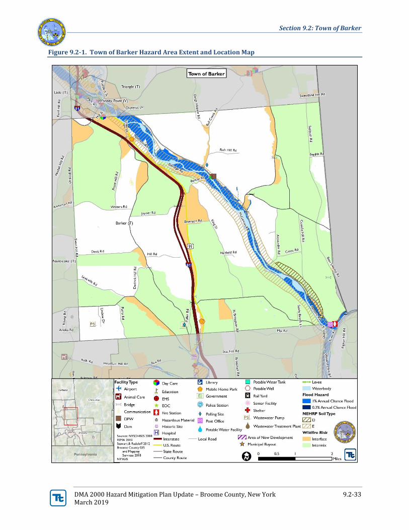
Section 9.2: Town of Barker
DMA 2000 Hazard Mitigation Plan Update – Broome County, New York 9.2-33 March 2019
Figure 9.2-1. Town of Barker Hazard Area Extent and Location Map
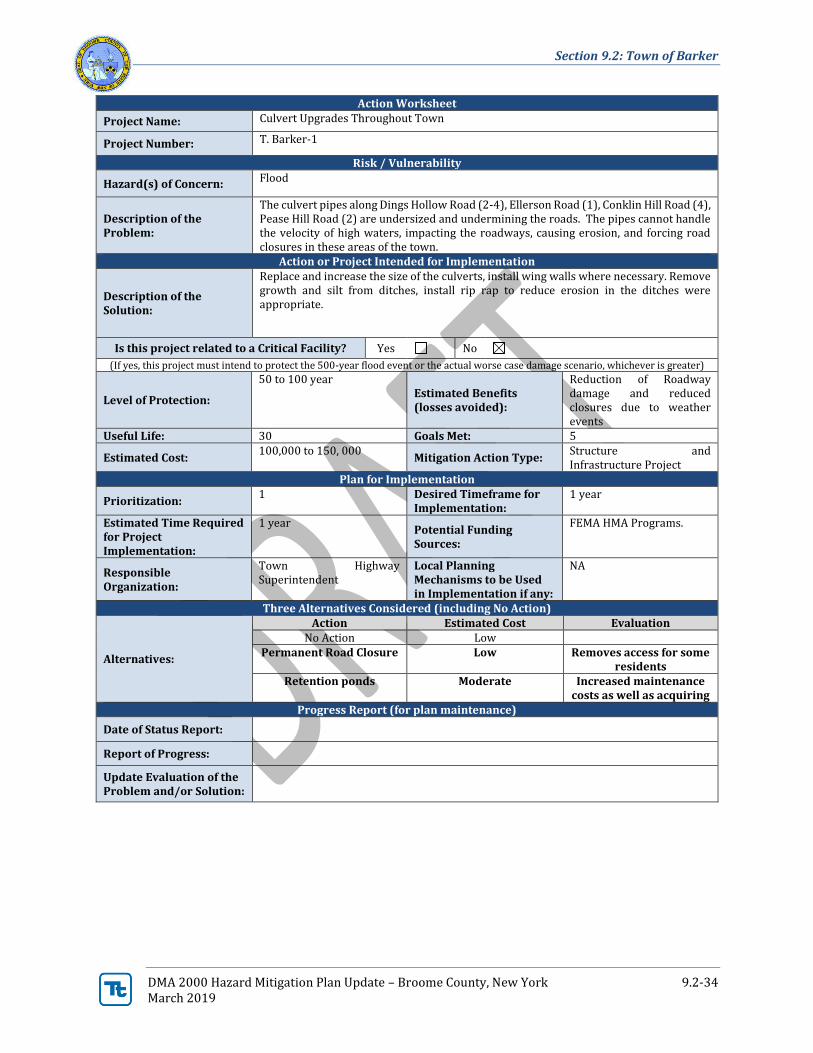
Section 9.2: Town of Barker
DMA 2000 Hazard Mitigation Plan Update – Broome County, New York 9.2-34 March 2019
Action Worksheet
Project Name: Culvert Upgrades Throughout Town
Project Number: T. Barker-1
Risk / Vulnerability
Hazard(s) of Concern: Flood
Description of the Problem:
The culvert pipes along Dings Hollow Road (2-4), Ellerson Road (1), Conklin Hill Road (4), Pease Hill Road (2) are undersized and undermining the roads. The pipes cannot handle the velocity of high waters, impacting the roadways, causing erosion, and forcing road closures in these areas of the town.
Action or Project Intended for Implementation
Description of the Solution:
Replace and increase the size of the culverts, install wing walls where necessary. Remove growth and silt from ditches, install rip rap to reduce erosion in the ditches were appropriate.
Is this project related to a Critical Facility? Yes No
(If yes, this project must intend to protect the 500-year flood event or the actual worse case damage scenario, whichever is greater)
Level of Protection:
50 to 100 year Estimated Benefits (losses avoided):
Reduction of Roadway damage and reduced closures due to weather events
Useful Life: 30 Goals Met: 5
Estimated Cost: 100,000 to 150, 000
Mitigation Action Type: Structure and Infrastructure Project
Plan for Implementation
Prioritization: 1 Desired Timeframe for
Implementation: 1 year
Estimated Time Required for Project Implementation:
1 year Potential Funding Sources:
FEMA HMA Programs.
Responsible Organization:
Town Highway Superintendent
Local Planning Mechanisms to be Used in Implementation if any:
NA
Three Alternatives Considered (including No Action)
Alternatives:
Action Estimated Cost Evaluation No Action Low
Permanent Road Closure Low Removes access for some residents
Retention ponds Moderate Increased maintenance costs as well as acquiring
Progress Report (for plan maintenance)
Date of Status Report:
Report of Progress:
Update Evaluation of the Problem and/or Solution:
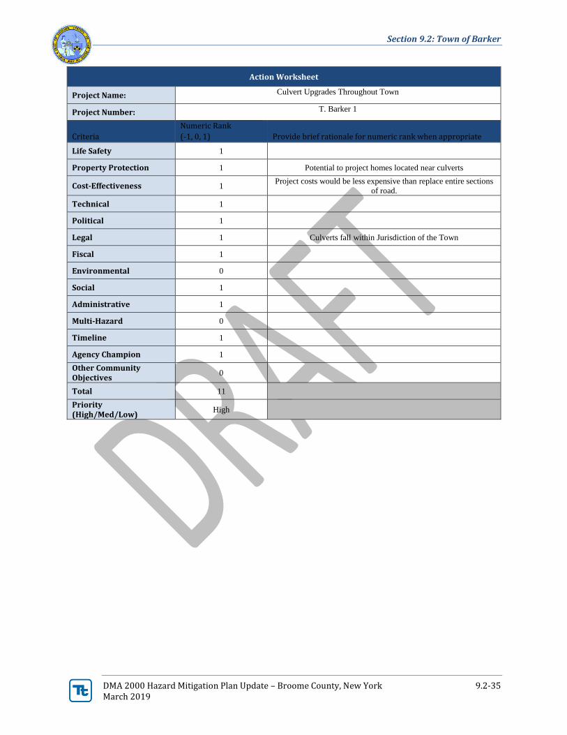
Section 9.2: Town of Barker
DMA 2000 Hazard Mitigation Plan Update – Broome County, New York 9.2-35 March 2019
Action Worksheet
Project Name: Culvert Upgrades Throughout Town
Project Number: T. Barker 1
Criteria
Numeric Rank
(-1, 0, 1) Provide brief rationale for numeric rank when appropriate
Life Safety 1
Property Protection 1 Potential to project homes located near culverts
Cost-Effectiveness 1 Project costs would be less expensive than replace entire sections
of road.
Technical 1
Political 1
Legal 1 Culverts fall within Jurisdiction of the Town
Fiscal 1
Environmental 0
Social 1
Administrative 1
Multi-Hazard 0
Timeline 1
Agency Champion 1
Other Community Objectives
0
Total 11
Priority (High/Med/Low)
High
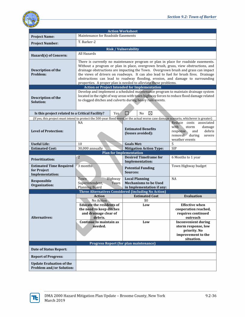
Section 9.2: Town of Barker
DMA 2000 Hazard Mitigation Plan Update – Broome County, New York 9.2-36 March 2019
Action Worksheet
Project Name: Maintenance for Roadside Easements
Project Number: T. Barker-2
Risk / Vulnerability
Hazard(s) of Concern: All Hazards
Description of the Problem:
There is currently no maintenance program or plan in place for roadside easements. Without a program or plan in place, overgrown brush, grass, view obstructions, and drainage obstructions are impacting the Town. Overgrown brush and grass can impact the views of drivers on roadways. It can also lead to fuel for brush fires. Drainage obstructions can lead to roadway flooding, erosion, and damage to surrounding properties. A proper plan is needed to alleviate these problems.
Action or Project Intended for Implementation
Description of the Solution:
Develop and implement a scheduled maintenance program to maintain drainage system located in the right of way areas with town highway forces to reduce flood damage related to clogged ditches and culverts during heavy rain events.
Is this project related to a Critical Facility? Yes No
(If yes, this project must intend to protect the 500-year flood event or the actual worse case damage scenario, whichever is greater)
Level of Protection:
NA
Estimated Benefits (losses avoided):
Reduce costs associated with storm damage response and debris removal during severe weather events
Useful Life: 10 Goals Met: 5 Estimated Cost: 30,000 annually Mitigation Action Type: SIP
Plan for Implementation
Prioritization: 2 Desired Timeframe for
Implementation: 6 Months to 1 year
Estimated Time Required for Project Implementation:
3 months Potential Funding Sources:
Town Highway budget
Responsible Organization:
Town Highway Superintendent, Town Planning Board
Local Planning Mechanisms to be Used in Implementation if any:
NA
Three Alternatives Considered (including No Action)
Alternatives:
Action Estimated Cost Evaluation No Action $0
Educate the residents of the need to keep ditches
and drainage clear of debris.
Low Effective when cooperation reached,
requires continued outreach
Continue to maintain as needed.
Low Inconvenient during storm response, low
priority. No improvement to the
situation. Progress Report (for plan maintenance)
Date of Status Report:
Report of Progress:
Update Evaluation of the Problem and/or Solution:

Section 9.2: Town of Barker
DMA 2000 Hazard Mitigation Plan Update – Broome County, New York 9.2-37 March 2019
Action Worksheet
Project Name: Maintenance for Roadside Easements
Project Number: T. Barker 2
Criteria Numeric Rank
(-1, 0, 1) Provide brief rationale for numeric rank when
appropriate
Life Safety 1 Current potential for flooding/brush fires which could impact the
safety of citizens would be avoided through mitigation.
Property Protection 1 Current potential for flooding/brush fires which could impact the
properties near easements.
Cost-Effectiveness 1
Technical 1
Political 1
Legal 1
Fiscal 1
Environmental 0
Social 0
Administrative 1
Multi-Hazard 1 Can prevent flooding and brush fires.
Timeline 0
Agency Champion 0
Other Community Objectives
0
Total 9
Priority (High/Med/Low)
Medium