![Using Multilateration and Extended Kalman Filter for ...828279/FULLTEXT01.pdfTrilateration, Fingerprinting, Landmarks, Cell ID, Multilateration, etc [3]. Although RFID RTLS is a promising](https://static.fdocuments.us/doc/165x107/5e535ef64ddc4d50064345b9/using-multilateration-and-extended-kalman-filter-for-828279fulltext01pdf-trilateration.jpg)
Multi Multilateration Multi lateration aDS-B · Multilateration ( MlaT ) MLAT ground stations...
26
EXECUTIVE REFERENCE GUIDE MULTILATERATION & ADS-B Organizations around the globe are turning to these revolutionary technologies. But what exactly is multilateration? How will it aid in the transition to ADS-B? Can it offer backup capabilities to ADS-B in the long term? What are its benefits? What about certification? Most importantly, how can it benefit your organization? is guide was developed to provide an easy-to-read reference for air traffic management, airport and airline professionals to answer these questions and more. www.MULTILATERATION.com MULTILATERATION & ADS-B MULTILATERATION & ADS-B CREATIVERGE DESIGNED AND DISTRIBUTED BY ERA CORPORATION WITH SUPPORT FROM EXECUTIVE REFERENCE GUIDE
Transcript of Multi Multilateration Multi lateration aDS-B · Multilateration ( MlaT ) MLAT ground stations...
ExEcu
tiv
E REfEREnc
E Gu
idE
Multilateration & aDS-B Organizations around the globe
are turning to these revolutionary technologies.
But what exactly is multilateration? How will it aid in the transition to ADS-B?
Can it offer backup capabilities to ADS-B in the long term? What are its benefits? What about certification?
Most importantly, how can it benefit your organization?
This guide was developed to provide an easy-to-read reference for air traffic management, airport and airline professionals
to answer these questions and more.
www.Multilateration.com
Mu
ltilateration
& a
DS-B
Multilateration & aDS-B
Creativerge
d E s i G n E d a n d d i st R i b u t E d by
era Corporation
w i t h s u p p o Rt f Ro m
E x E c u t i v E R E f E R E n c E G u i d E
1
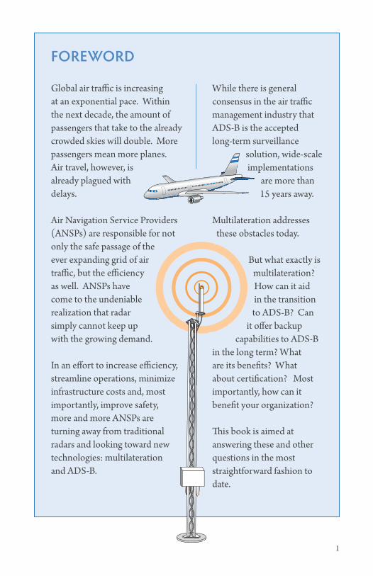
Foreword
Global air traffic is increasing at an exponential pace. Within the next decade, the amount of passengers that take to the already crowded skies will double. More passengers mean more planes. Air travel, however, is already plagued with delays.
Air Navigation Service Providers (ANSPs) are responsible for not only the safe passage of the ever expanding grid of air traffic, but the efficiency as well. ANSPs have come to the undeniable realization that radar simply cannot keep up with the growing demand.
In an effort to increase efficiency, streamline operations, minimize infrastructure costs and, most importantly, improve safety, more and more ANSPs are turning away from traditional radars and looking toward new technologies: multilateration and ADS-B.
While there is general consensus in the air traffic management industry that ADS-B is the accepted long-term surveillance
solution, wide-scale implementations
are more than 15 years away.
Multilateration addresses these obstacles today.
But what exactly is multilateration? How can it aid in the transition to ADS-B? Can
it offer backup capabilities to ADS-B
in the long term? What are its benefits? What about certification? Most importantly, how can it benefit your organization?
This book is aimed at answering these and other questions in the most straightforward fashion to date.
2 multilateration & ads-b: executive reference guide table of contents 3
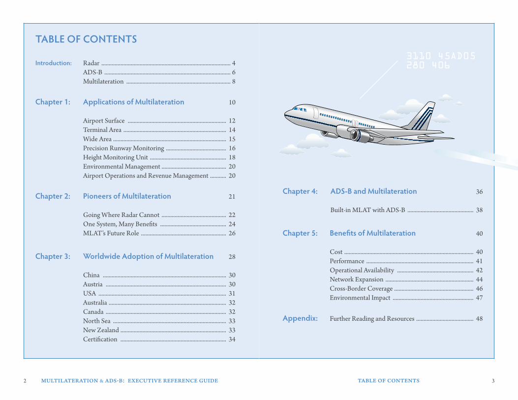
Table oF ConTenTs
Introduction: Radar ........................................................................................ 4 ADS-B ...................................................................................... 6 Multilateration ....................................................................... 8
Chapter 1: applications of Multilateration 10
Airport Surface ................................................................... 12 Terminal Area ...................................................................... 14 Wide Area ............................................................................. 15 Precision Runway Monitoring ......................................... 16 Height Monitoring Unit .................................................... 18 Environmental Management ............................................ 20 Airport Operations and Revenue Management ........... 20
Chapter 2: Pioneers of Multilateration 21
Going Where Radar Cannot ............................................ 22 One System, Many Benefits ............................................. 24 MLAT’s Future Role .......................................................... 26
Chapter 3: worldwide adoption of Multilateration 28
China .................................................................................... 30 Austria .................................................................................. 30 USA ....................................................................................... 31 Australia ................................................................................ 32 Canada .................................................................................. 32 North Sea ............................................................................. 33 New Zealand ........................................................................ 33 Certification ........................................................................ 34
Chapter 4: ads-b and Multilateration 36
Built-in MLAT with ADS-B ............................................. 38
Chapter 5: benefits of Multilateration 40
Cost ........................................................................................ 40 Performance ......................................................................... 41 Operational Availability .................................................... 42 Network Expansion ............................................................ 44 Cross-Border Coverage ...................................................... 46 Environmental Impact ....................................................... 47
appendix: Further Reading and Resources ....................................... 48
3110 45AD05280 406
4 multilateration & ads-b: executive reference guide introduction 5
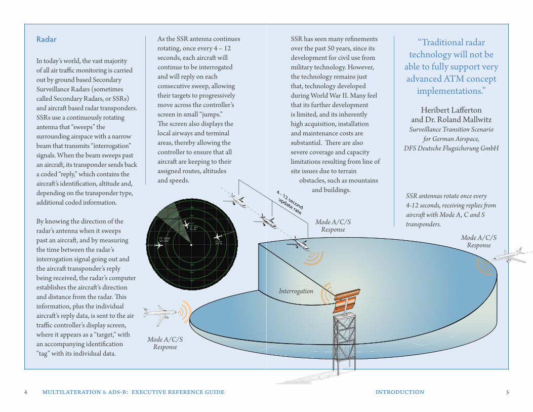
In today’s world, the vast majority of all air traffic monitoring is carried out by ground based Secondary Surveillance Radars (sometimes called Secondary Radars, or SSRs) and aircraft based radar transponders. SSRs use a continuously rotating antenna that “sweeps” the surrounding airspace with a narrow beam that transmits “interrogation” signals. When the beam sweeps past an aircraft, its transponder sends back a coded “reply,” which contains the aircraft’s identification, altitude and, depending on the transponder type, additional coded information.
By knowing the direction of the radar’s antenna when it sweeps past an aircraft, and by measuring the time between the radar’s interrogation signal going out and the aircraft transponder’s reply being received, the radar’s computer establishes the aircraft’s direction and distance from the radar. This information, plus the individual aircraft’s reply data, is sent to the air traffic controller’s display screen, where it appears as a “target,” with an accompanying identification “tag” with its individual data.
SSR has seen many refinements over the past 50 years, since its development for civil use from military technology. However, the technology remains just that, technology developed during World War II. Many feel that its further development is limited, and its inherently high acquisition, installation and maintenance costs are substantial. There are also severe coverage and capacity limitations resulting from line of site issues due to terrain obstacles, such as mountains and buildings.
As the SSR antenna continues rotating, once every 4 – 12 seconds, each aircraft will continue to be interrogated and will reply on each consecutive sweep, allowing their targets to progressively move across the controller’s screen in small “jumps.” The screen also displays the local airways and terminal areas, thereby allowing the controller to ensure that all aircraft are keeping to their assigned routes, altitudes and speeds.
“Traditional radar technology will not be
able to fully support very advanced ATM concept
implementations.”
Heribert Lafferton and Dr. Roland Mallwitz
Surveillance Transition Scenario for German Airspace,
DFS Deutsche Flugsicherung GmbH
radar
SSR antennas rotate once every 4-12 seconds, receiving replies from aircraft with Mode A, C and S transponders.
100
100
200
200
300
300
FT 221212.232
FT 33323.66
FT 564123.56
Interrogation
Mode A/C/S Response
Mode A/C/S Response
Mode A/C/S Response
6 multilateration & ads-b: executive reference guide introduction 7
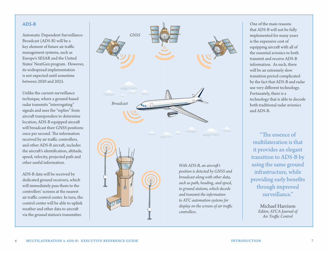
Automatic Dependent Surveillance-Broadcast (ADS-B) will be a key element of future air traffic management systems, such as Europe’s SESAR and the United States’ NextGen program. However, its widespread implementation is not expected until sometime between 2020 and 2025.
Unlike the current surveillance technique, where a ground-based radar transmits “interrogating” signals and uses the “replies” from aircraft transponders to determine location, ADS-B equipped aircraft will broadcast their GNSS positions once per second. The information received by air traffic controllers, and other ADS-B aircraft, includes the aircraft’s identification, altitude, speed, velocity, projected path and other useful information.
ADS-B data will be received by dedicated ground receivers, which will immediately pass them to the controllers’ screens at the nearest air traffic control center. In turn, the control center will be able to uplink weather and other data to aircraft via the ground station’s transmitter.
One of the main reasons that ADS-B will not be fully implemented for many years is the expensive cost of equipping aircraft with all of the essential avionics to both transmit and receive ADS-B information. As such, there will be an extremely slow transition period complicated by the fact that ADS-B and radar use very different technology. Fortunately, there is a technology that is able to decode both traditional radar avionics and ADS-B.
With ADS-B, an aircraft’s position is detected by GNSS and broadcast along with other data, such as path, heading, and speed, to ground stations, which decode and transmit the information to ATC automation systems for display on the screens of air traffic controllers.
ads-b
“The essence of multilateration is that it provides an elegant
transition to ADS-B by using the same ground
infrastructure, while providing early benefits
through improved surveillance.”
Michael Harrison Editor, ATCA Journal of
Air Traffic Control
Broadcast
GNSS
8 multilateration & ads-b: executive reference guide introduction 9
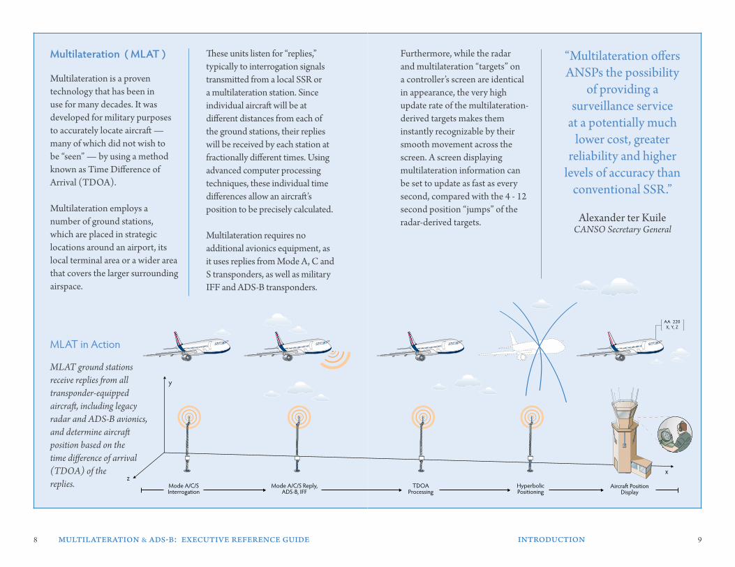
Multilateration is a proven technology that has been in use for many decades. It was developed for military purposes to accurately locate aircraft — many of which did not wish to be “seen” — by using a method known as Time Difference of Arrival (TDOA).
Multilateration employs a number of ground stations, which are placed in strategic locations around an airport, its local terminal area or a wider area that covers the larger surrounding airspace.
Furthermore, while the radar and multilateration “targets” on a controller’s screen are identical in appearance, the very high update rate of the multilateration-derived targets makes them instantly recognizable by their smooth movement across the screen. A screen displaying multilateration information can be set to update as fast as every second, compared with the 4 - 12 second position “jumps” of the radar-derived targets.
These units listen for “replies,” typically to interrogation signals transmitted from a local SSR or a multilateration station. Since individual aircraft will be at different distances from each of the ground stations, their replies will be received by each station at fractionally different times. Using advanced computer processing techniques, these individual time differences allow an aircraft’s position to be precisely calculated.
Multilateration requires no additional avionics equipment, as it uses replies from Mode A, C and S transponders, as well as military IFF and ADS-B transponders.
“Multilateration offers ANSPs the possibility
of providing a surveillance service
at a potentially much lower cost, greater
reliability and higher levels of accuracy than
conventional SSR.”
Alexander ter Kuile CANSO Secretary General
Multilateration ( MlaT )
MLAT ground stations receive replies from all transponder-equipped aircraft, including legacy radar and ADS-B avionics, and determine aircraft position based on the time difference of arrival (TDOA) of the replies.
MLAT in Action
Mode A/C/S Reply,ADS-B, IFF
TDOAProcessing
HyperbolicPositioning
Mode A/C/S Interrogation
AA 220X, Y, Z
y
zx
Mode A/C/S Reply,ADS-B, IFF
TDOAProcessing
HyperbolicPositioning
Mode A/C/S Interrogation
AA 220X, Y, Z
y
zx
10 multilateration & ads-b: executive reference guide applications of multilateration 11
1000 ft
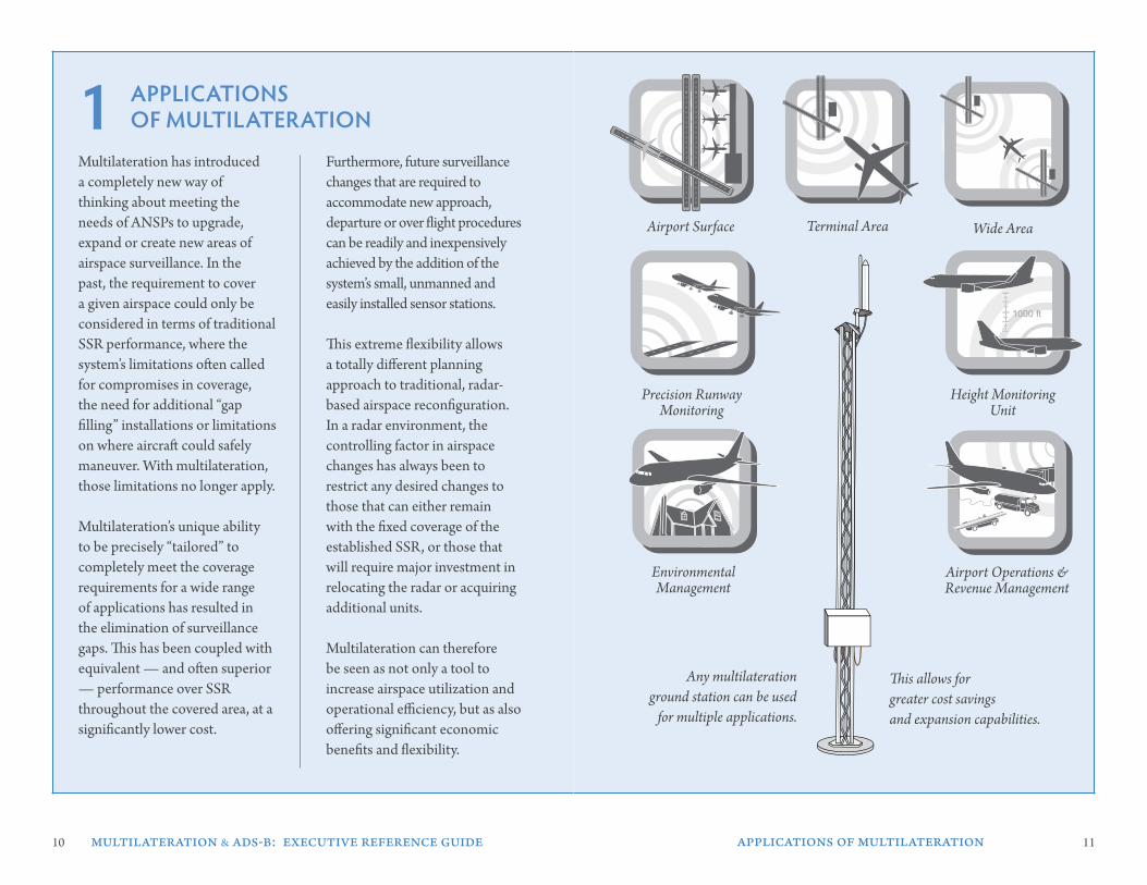
aPPlICaTIons oF MulTIlaTeraTIon
Terminal Area Wide Area
Any multilateration ground station can be used
for multiple applications.
Multilateration has introduced a completely new way of thinking about meeting the needs of ANSPs to upgrade, expand or create new areas of airspace surveillance. In the past, the requirement to cover a given airspace could only be considered in terms of traditional SSR performance, where the system’s limitations often called for compromises in coverage, the need for additional “gap filling” installations or limitations on where aircraft could safely maneuver. With multilateration, those limitations no longer apply.
Multilateration’s unique ability to be precisely “tailored” to completely meet the coverage requirements for a wide range of applications has resulted in the elimination of surveillance gaps. This has been coupled with equivalent — and often superior — performance over SSR throughout the covered area, at a significantly lower cost.
Furthermore, future surveillance changes that are required to accommodate new approach, departure or over flight procedures can be readily and inexpensively achieved by the addition of the system’s small, unmanned and easily installed sensor stations.
This extreme flexibility allows a totally different planning approach to traditional, radar-based airspace reconfiguration. In a radar environment, the controlling factor in airspace changes has always been to restrict any desired changes to those that can either remain with the fixed coverage of the established SSR, or those that will require major investment in relocating the radar or acquiring additional units.
Multilateration can therefore be seen as not only a tool to increase airspace utilization and operational efficiency, but as also offering significant economic benefits and flexibility.
Precision RunwayMonitoring
Height Monitoring Unit
Airport Operations & Revenue Management
This allows for greater cost savings and expansion capabilities.
Airport Surface
EnvironmentalManagement
1
12 13
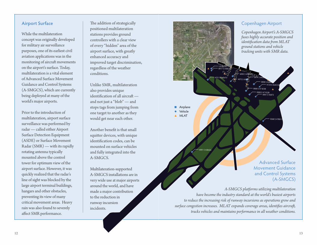
While the multilateration concept was originally developed for military air surveillance purposes, one of its earliest civil aviation applications was in the monitoring of aircraft movements on the airport’s surface. Today, multilateration is a vital element of Advanced Surface Movement Guidance and Control Systems (A-SMGCS), which are currently being deployed at many of the world’s major airports.
Prior to the introduction of multilateration, airport surface surveillance was performed by radar — called either Airport Surface Detection Equipment (ASDE) or Surface Movement Radar (SMR) — with its rapidly rotating antenna typically mounted above the control tower for optimum view of the airport surface. However, it was quickly realized that the radar’s line of sight was blocked by the large airport terminal buildings, hangars and other obstacles, preventing its view of many critical movement areas. Heavy rain was also found to severely affect SMR performance.
airport surface
MLATVehicleAirplane
0000 S 45B64C
0000 S 47 833B
0477 S 4A983
0000 S 47 922B
6001 S 45B425
623 S 456E47V
6005 S 478387
6001 S 45872
0260 S 478011
4073 S 45091
4134 S 45AC32
6017 S A481ABS 47801A
Copenhagen Airport’s A-SMGCS fuses highly accurate position and identification data from MLAT ground stations and vehicle tracking units with SMR data.
Copenhagen Airport
Advanced Surface Movement Guidance and Control Systems
(A-SMGCS)
MLATVehicleAirplane
0000 S 45B64C
0000 S 47 833B
0477 S 4A983
0000 S 47 922B
6001 S 45B425
623 S 456E47V
6005 S 478387
6001 S 45872
0260 S 478011
4073 S 45091
4134 S 45AC32
6017 S A481ABS 47801A
A-SMGCS platforms utilizing multilateration have become the industry standard at the world’s busiest airports
to reduce the increasing risk of runway incursions as operations grow and surface congestion increases. MLAT expands coverage areas, identifies aircraft,
tracks vehicles and maintains performance in all weather conditions.
The addition of strategically positioned multilateration stations provides ground controllers with a clear view of every “hidden” area of the airport surface, with greatly enhanced accuracy and improved target discrimination, regardless of the weather conditions.
Unlike SMR, multilateration also provides unique identification of all aircraft — and not just a “blob” — and stops tags from jumping from one target to another as they would get near each other.
Another benefit is that small squitter devices, with unique identification codes, can be mounted on surface vehicles and fully integrated into the A-SMGCS.
Multilateration-supported A-SMGCS installations are in very wide use at major airports around the world, and have made a major contribution to the reduction in runway incursion incidents.
14 15
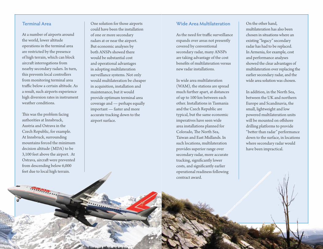
As the need for traffic surveillance expands over areas not presently covered by conventional secondary radar, many ANSPs are taking advantage of the cost benefits of multilateration versus new radar installations.
In wide area multilateration (WAM), the stations are spread much further apart, at distances of up to 100 km between each other. Installations in Tasmania and the Czech Republic are typical, but the same economic imperatives have seen wide area installations planned for Colorado, The North Sea, Taiwan and East Midlands. In such locations, multilateration provides superior range over secondary radar, more accurate tracking, significantly lower costs, and significantly earlier operational readiness following contract award.
wide area Multilateration On the other hand, multilateration has also been chosen in situations where an existing “legacy” secondary radar has had to be replaced. In Armenia, for example, cost and performance analyses showed the clear advantages of multilateration over replacing the earlier secondary radar, and the wide area solution was chosen.
In addition, in the North Sea, between the UK and northern Europe and Scandinavia, the small, lightweight and low powered multilateration units will be mounted on offshore drilling platforms to provide “better than radar” performance down to the surface, in locations where secondary radar would have been impractical.
At a number of airports around the world, lower altitude operations in the terminal area are restricted by the presence of high terrain, which can block aircraft interrogations from nearby secondary radars. In turn, this prevents local controllers from monitoring terminal area traffic below a certain altitude. As a result, such airports experience high diversion rates in instrument weather conditions.
This was the problem facing authorities at Innsbruck, Austria and Ostrava in the Czech Republic, for example. At Innsbruck, surrounding mountains forced the minimum decision altitude (MDA) to be 3,100 feet above the airport. At Ostrava, aircraft were prevented from descending below 6,000 feet due to local high terrain.
One solution for those airports could have been the installation of one or more secondary radars at or near the airport. But economic analyses by both ANSPs showed there would be substantial cost and operational advantages in adopting multilateration surveillance systems. Not only would multilateration be cheaper in acquisition, installation and maintenance, but it would provide optimum terminal area coverage and — perhaps equally important — faster and more accurate tracking down to the airport surface.
Terminal area
14 15
16 17
BA 220X, Y, Z
BA 220X, Y, Z
BA 5270X, Y, Z
BA 5270X, Y, Z
BA 5270X, Y, Z
BA 220X, Y, Z
BA 5270Z
BA 220X, Y, Z
BA 220X, Y, Z
BA 5270X, Y, Z
BA 5270X, Y, Z
BA 5270X, Y, Z
BA 220X, Y, Z
BA 5270Z
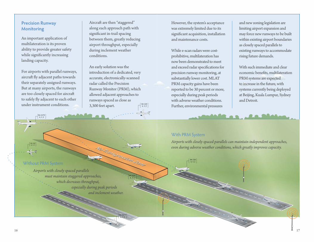
An important application of multilateration is its proven ability to provide greater safety while significantly increasing landing capacity.
For airports with parallel runways, aircraft fly adjacent paths towards their separately assigned runways. But at many airports, the runways are too closely spaced for aircraft to safely fly adjacent to each other under instrument conditions.
Precision runway Monitoring
Aircraft are then “staggered” along each approach path with significant in-trail spacing between them, greatly reducing airport throughput, especially during inclement weather conditions.
An early solution was the introduction of a dedicated, very accurate, electronically-scanned radar called the Precision Runway Monitor (PRM), which allowed adjacent approaches to runways spaced as close as 3,300 feet apart.
However, the system’s acceptance was extremely limited due to its significant acquisition, installation and maintenance costs.
While e-scan radars were cost-prohibitive, multilateration has now been demonstrated to meet and exceed radar specifications for precision runway monitoring, at substantially lower cost. MLAT PRM capacity gains have been reported to be 30 percent or more, especially during peak periods with adverse weather conditions. Further, environmental pressures
With PRM System
Without PRM System
and new zoning legislation are limiting airport expansion and may force new runways to be built within existing airport boundaries as closely spaced parallels to existing runways to accommodate rising future demands.
With such immediate and clear economic benefits, multilateration PRM systems are expected to increase in the future, with systems currently being deployed at Beijing, Kuala Lumpur, Sydney and Detroit.
Airports with closely spaced parallels must maintain staggered approaches, which decreases throughput, especially during peak periods and inclement weather.
Airports with closely spaced parallels can maintain independent approaches, even during adverse weather conditions, which greatly improves capacity.
18 multilateration & ads-b: executive reference guide applications of multilateration 19
Additional Capacitypp yp y
FL370
FL390
FL360
FL380
FL400
LA 220X, Y, Z
BA 1450X, Y, Z
AA 90X, Y, Z
BA 882X, Y, Z
UA110X, Y, Z
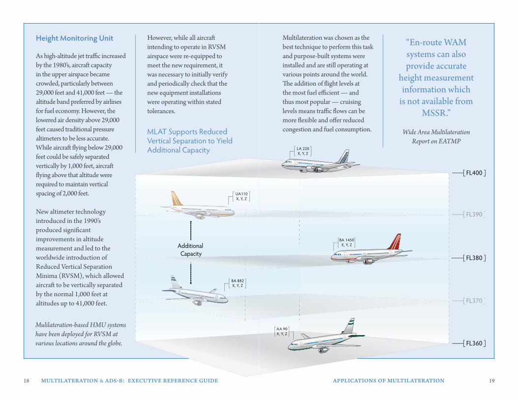
Multilateration was chosen as the best technique to perform this task and purpose-built systems were installed and are still operating at various points around the world. The addition of flight levels at the most fuel efficient — and thus most popular — cruising levels means traffic flows can be more flexible and offer reduced congestion and fuel consumption.
As high-altitude jet traffic increased by the 1980’s, aircraft capacity in the upper airspace became crowded, particularly between 29,000 feet and 41,000 feet — the altitude band preferred by airlines for fuel economy. However, the lowered air density above 29,000 feet caused traditional pressure altimeters to be less accurate. While aircraft flying below 29,000 feet could be safely separated vertically by 1,000 feet, aircraft flying above that altitude were required to maintain vertical spacing of 2,000 feet.
New altimeter technology introduced in the 1990’s produced significant improvements in altitude measurement and led to the worldwide introduction of Reduced Vertical Separation Minima (RVSM), which allowed aircraft to be vertically separated by the normal 1,000 feet at altitudes up to 41,000 feet.
However, while all aircraft intending to operate in RVSM airspace were re-equipped to meet the new requirement, it was necessary to initially verify and periodically check that the new equipment installations were operating within stated tolerances.
Height Monitoring unit “En-route WAM systems can also provide accurate
height measurement information which
is not available from MSSR.”
Wide Area Multilateration Report on EATMP
Mulilateration-based HMU systems have been deployed for RVSM at various locations around the globe.
Additional Capacitypp yp y
FL370
FL390
FL360
FL380
FL400
LA 220X, Y, Z
BA 1450X, Y, Z
AA 90X, Y, Z
BA 882X, Y, Z
UA110X, Y, Z
MLAT Supports Reduced Vertical Separation to Yield Additional Capacity
20 multilateration & ads-b: executive reference guide 21
PIoneers oF MulTIlaTeraTIon
Today, many airports require strict adherence to noise abatement procedures. However, noise complaints from nearby residential areas are a continuing concern to airport operators, and identifying the aircraft which caused such complaints is often difficult.
One of the early applications of multilateration was to perform this function. The system records the identification of every arriving and departing aircraft, along with its precise path over the ground, and can show the exact time it passed over any point on its path. The recorded data have already been accepted as legal evidence in certain jurisdictions.
As other environmental regulations come into effect, multilateration can provide airport management with an extremely effective and rapidly accessible source of information on noise, emissions and other flight operations data.
Airports need to constantly measure and analyze aircraft and vehicle movements, as a backup in any given area on an airport’s surface can create a domino effect that cripples an airport’s operation.
Multilateration systems provide airline and airport personnel with real-time, shared situational awareness and tracking that supports Collaborative Decision Making (CDM) for the planning and scheduling of airport resources to improve gate management and orchestrate ramp movements.
Typically, airports have relied on airlines or aircraft to self-report their usage of key revenue generators, such as landing fees, de-icing costs, gate usage, etc. This has undoubtedly led to a faulted system, as airports have had no system to check accuracy, which has in turn led to lost revenue.
Multilateration provides flight track and identification data to automatically produce timely and accurate invoices.
environmental Management
airport operations & revenue Management 2
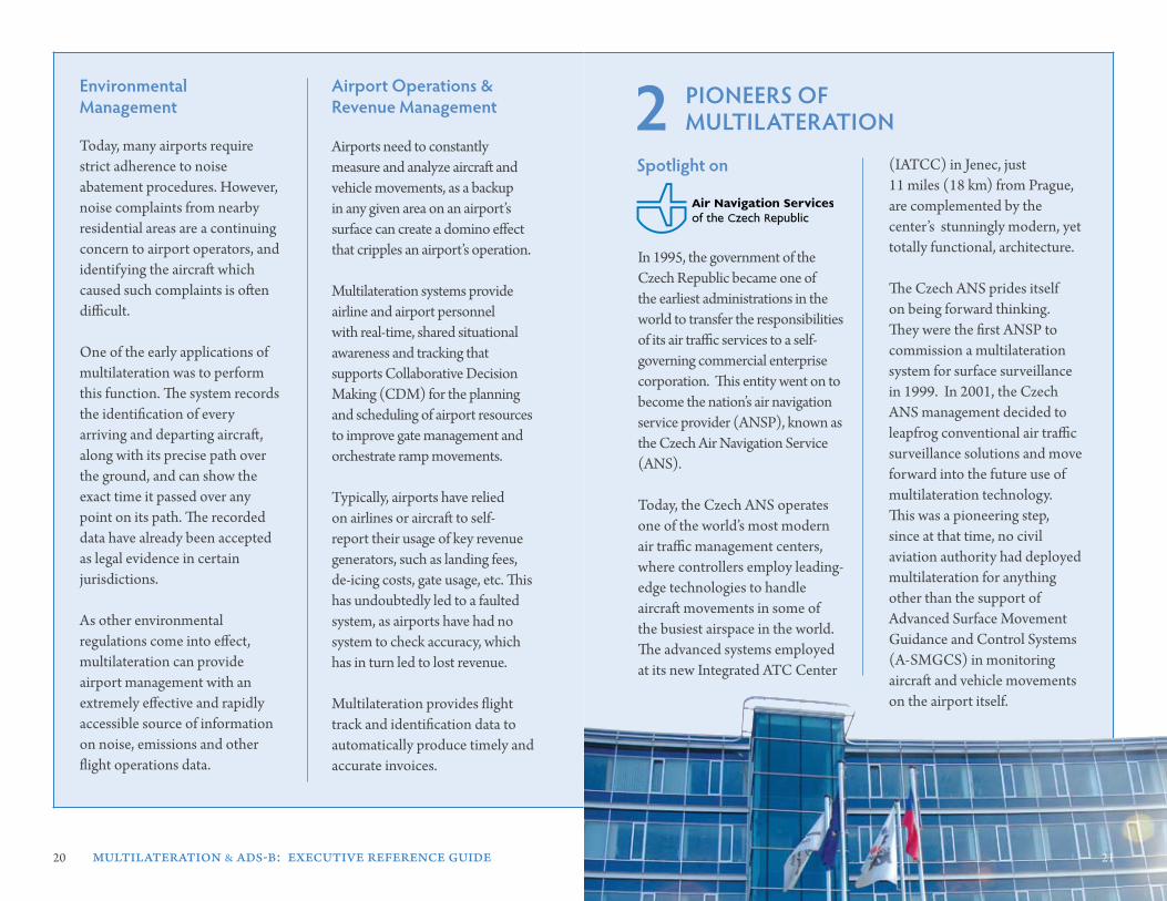
In 1995, the government of the Czech Republic became one of the earliest administrations in the world to transfer the responsibilities of its air traffic services to a self-governing commercial enterprise corporation. This entity went on to become the nation’s air navigation service provider (ANSP), known as the Czech Air Navigation Service (ANS). Today, the Czech ANS operates one of the world’s most modern air traffic management centers, where controllers employ leading-edge technologies to handle aircraft movements in some of the busiest airspace in the world. The advanced systems employed at its new Integrated ATC Center
(IATCC) in Jenec, just 11 miles (18 km) from Prague, are complemented by the center’s stunningly modern, yet totally functional, architecture.
The Czech ANS prides itself on being forward thinking. They were the first ANSP to commission a multilateration system for surface surveillance in 1999. In 2001, the Czech ANS management decided to leapfrog conventional air traffic surveillance solutions and move forward into the future use of multilateration technology. This was a pioneering step, since at that time, no civil aviation authority had deployed multilateration for anything other than the support of Advanced Surface Movement Guidance and Control Systems (A-SMGCS) in monitoring aircraft and vehicle movements on the airport itself.
21
spotlight on
22 multilateration & ads-b: executive reference guide pioneers of multilateration 23
SSR MLATMLAT
UA 2320X, Y, Z
FL60
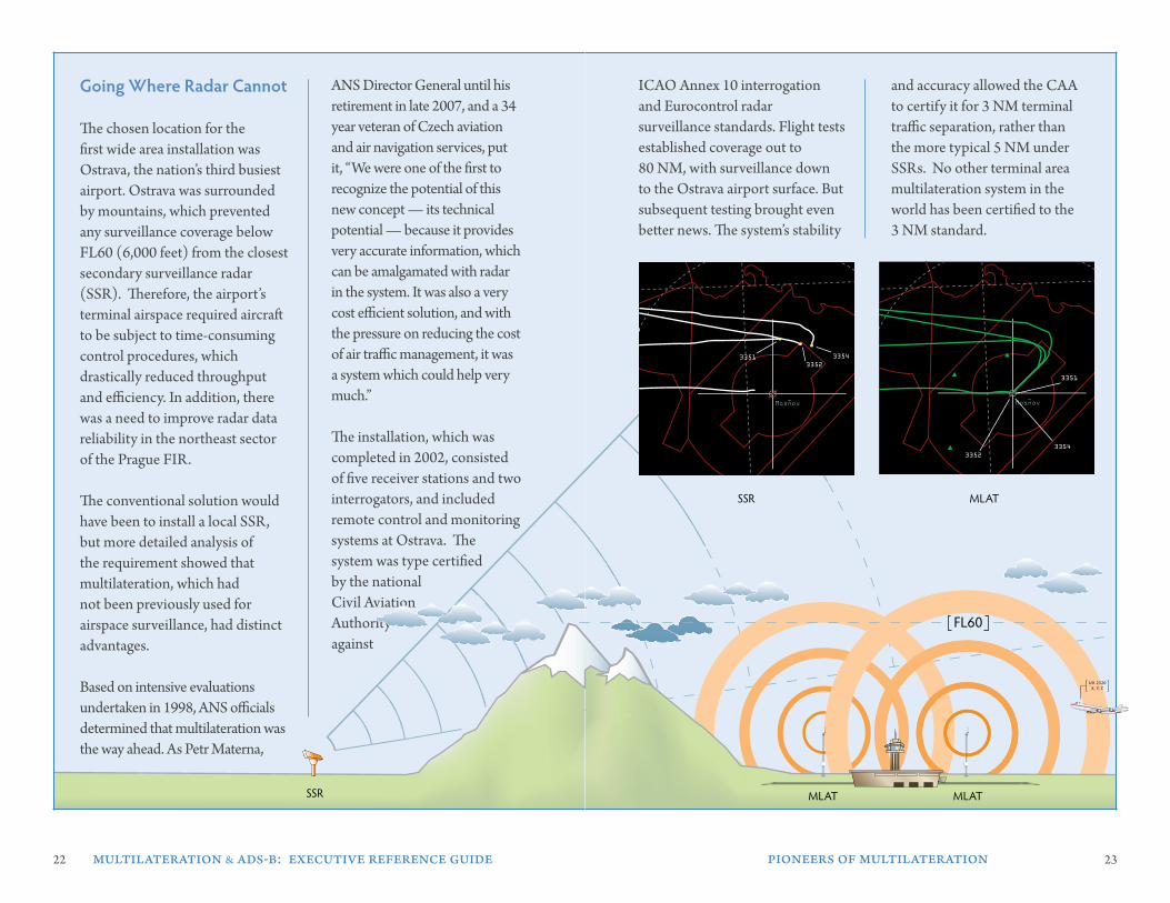
Going where radar Cannot
The chosen location for the first wide area installation was Ostrava, the nation’s third busiest airport. Ostrava was surrounded by mountains, which prevented any surveillance coverage below FL60 (6,000 feet) from the closest secondary surveillance radar (SSR). Therefore, the airport’s terminal airspace required aircraft to be subject to time-consuming control procedures, which drastically reduced throughput and efficiency. In addition, there was a need to improve radar data reliability in the northeast sector of the Prague FIR. The conventional solution would have been to install a local SSR, but more detailed analysis of the requirement showed that multilateration, which had not been previously used for airspace surveillance, had distinct advantages. Based on intensive evaluations undertaken in 1998, ANS officials determined that multilateration was the way ahead. As Petr Materna,
ANS Director General until his retirement in late 2007, and a 34 year veteran of Czech aviation and air navigation services, put it, “We were one of the first to recognize the potential of this new concept — its technical potential — because it provides very accurate information, which can be amalgamated with radar in the system. It was also a very cost efficient solution, and with the pressure on reducing the cost of air traffic management, it was a system which could help very much.” The installation, which was completed in 2002, consisted of five receiver stations and two interrogators, and included remote control and monitoring systems at Ostrava. The system was type certified by the national Civil Aviation Authority against
ICAO Annex 10 interrogation and Eurocontrol radar surveillance standards. Flight tests established coverage out to 80 NM, with surveillance down to the Ostrava airport surface. But subsequent testing brought even better news. The system’s stability
and accuracy allowed the CAA to certify it for 3 NM terminal traffic separation, rather than the more typical 5 NM under SSRs. No other terminal area multilateration system in the world has been certified to the 3 NM standard.
Mosnov~Mosnov~
33513352
3354
MLATSSR
Mosnov~Mosnov~
33513352
3354
Mosnov~
3351
33523354
SSR MLATMLAT
UA 2320X, Y, Z
FL60
24 25
first, to assure that the necessary high accuracy and probability of detection would support the monitoring of approaches on the airport’s planned parallel runways. Second, it needed to provide the precision, resolution and low altitude detection of all aircraft in the terminal area. Third, it had to provide flight operating services throughout the FIR, with a required overlap of at least 30 NM with neighboring countries’ FIRs.
After extensive feasibility and cost studies, multilateration was the clear choice and installation of the wide area configuration commenced. The MLAT system included 10 receiver stations, interrogators and test transponders, and its surveillance data was fully integrated into Eurocontrol’s ARTAS. Technical testing showed that the originally
specified system range of 80 NM was substantially exceeded, with 98 - 99% probability of detection as far away as 120 NM and demonstrated significant improvement in accuracy and target resolution over the present SSR serving the Prague FIR.
As well, the new system had another advantage. While the two conventional radars were operating, the multilateration receiver stations would continue to monitor all traffic in its passive, i.e., non-interrogating, surveillance mode. In this set-up, the system would provide an independent, non-radar check of radar performance. However, should its monitoring of the two radars indicate an incipient or actual failure of either, it would immediately commence active interrogation to assure a seamless changeover.
Do controllers see any difference on their screens when multilateration switches on? No, according to ANS surveillance manager Ivan Uhlir. “There is no difference,” he states, “between multilateration and radar from an operational perspective. The controllers have exactly the same picture.”
By taking this step and supplanting radar with wide area multilateration to meet Eurocontrol’s new terminal area requirement, the ANS established yet another world first in air traffic management.
one system, Many benefits
Due to their overwhelming success with multilateration in Ostrava, ANS officials launched a program to install a much larger multilateration surveillance network around Prague’s Ruzyne Airport. The system needed to provide the full-time surveillance redundancy required by Eurocontrol for major airports. While Prague’s terminal airspace was already served by two SSRs, the new requirement called for continuous operation of two surveillance systems at all times, which meant that three surveillance sources had to be constantly available if any one of them experienced failure or required maintenance.
Besides meeting the Eurocontrol mandate, the new system needed to fulfill three key objectives for the ANS as well. These were,
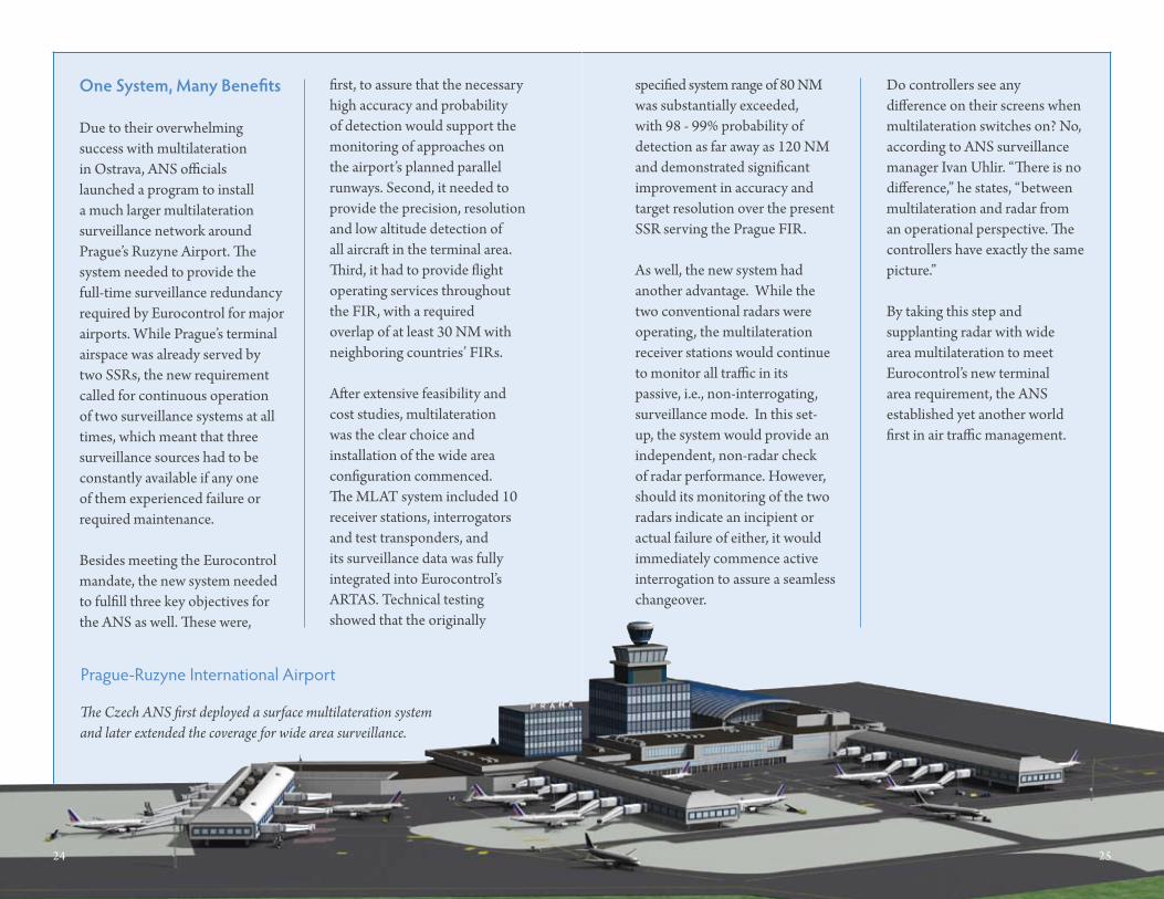
The Czech ANS first deployed a surface multilateration system and later extended the coverage for wide area surveillance.
24 25
Prague-Ruzyne International Airport
26 multilateration & ads-b: executive reference guide pioneers of multilateration 27
MlaT’s Future role
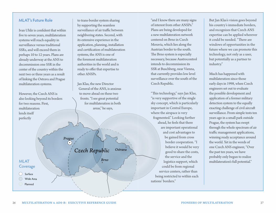
Ivan Uhlir is confident that within five to seven years, multilateration systems will reach equality in surveillance versus traditional SSRs, and will exceed them in perhaps 10 to 12 years. Plans are already underway at the ANS to decommission one SSR in the center of the country within the next two or three years as a result of linking the Ostrava and Prague multilateration systems.
However, the Czech ANS is also looking beyond its borders for two reasons. First, multilateration lends itself perfectly
to trans-border system sharing by supporting the seamless surveillance of air traffic between neighboring states. Second, with its extensive experience in the application, planning, installation and certification of multilateration systems, the ANS is one of the foremost multilateration authorities in the world and is ready to offer that expertise to other ANSPs.
Jan Klas, the new Director General of the ANS, is anxious to move ahead on these two fronts. “I see great potential
for multilateration in both areas,” he says,
“and I know there are many signs of interest from other ANSPs.” Plans are being developed for a new multilateration network centered on Brno in Czech Moravia, which lies along the Austrian border to the south. The Brno system is especially necessary, because Austrocontrol intends to decommission its SSR at Buschberg, near Vienna, that currently provides low level surveillance over the south of the Czech Republic.
“This technology,” says Jan Klas, “is very supportive of the single sky concept, which is particularly important in Central Europe, where the airspace is very
fragmented.” Looking further ahead, he feels that there
are important operational and cost advantages to
be gained from cross border cooperation. “I believe it would be very good to share the costs, the service and the
logistics support, which could be from regional
service centers, rather than being restricted to within each
nations’ borders.”
But Jan Klas’s vision goes beyond his country’s immediate borders, and recognizes that Czech ANS expertise can be applied wherever it could be needed. “There are windows of opportunities in the future where we can promote this technology, not only as a user, but potentially as a partner to industry.”
Much has happened with multilateration since those early days in 1998, when Czech engineers set out to evaluate the possible development and application of a former military detection system to the equally exacting challenge of civil aircraft surveillance. From simple tests ten years ago in a small park outside Prague, the system has swept through the whole spectrum of air traffic management applications, winning ready acceptance around the world. Yet in the words of one Czech ANS engineer, “Over the past ten years, we have probably only begun to realize multilateration’s full potential.”
Surface
Wide Area
Planned
MLATCoverage
Czech Republic
Prague
Brno
Ostrava
g
Surface
Wide Area
Planned
MLATCoverage
Czech Republic
Prague
Brno
Ostrava
g

28 worldwide adoption of multilateration 29
worldwIde adoPTIon oF MulTIlaTeraTIon
The use of multilateration has been growing globally in recent years. Interestingly, the very nature of multilateration deployments around the world, their various applications and characteristics, underscores the tremendous flexibility of the technology. This section highlights some unique worldwide applications of multilateration, and discusses the specific requirements of each that the system has successfully addressed. This is followed by a description of the certification process used in these applications to assure that the performance and safety levels traditionally applied to secondary radar are met, and in many areas exceeded, by
“performance-based” standard applicable to all systems in each of the three CNS groups. Under this new certification approach to surveillance, for example, multilateration and secondary radar —
which are very different technically — would be required to meet identical levels of performance. The section closes with a brief description of key aviation organizations who are currently developing future performance-based standards for surveillance systems.
The global adoption of multilateration is illustrated in the map below with highlighted countries deploying multilateration systems across six continents.
multilateration surveillance systems. Currently, aviation’s Communications, Navigation and Surveillance (CNS) systems are gradually transitioning from the traditional approach of specifying the precise technical characteristics of individual systems to a
3
30 31
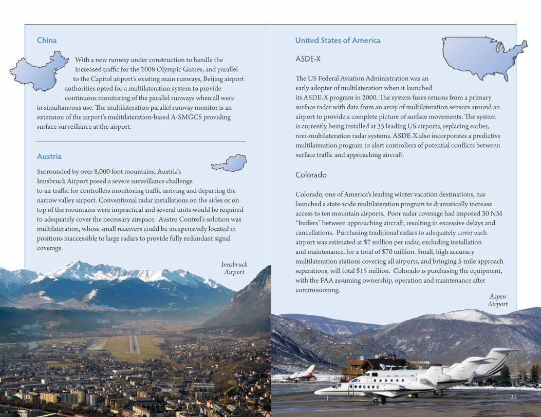
austria
Colorado
Colorado, one of America’s leading winter vacation destinations, has launched a state-wide multilateration program to dramatically increase access to ten mountain airports. Poor radar coverage had imposed 30 NM “buffers” between approaching aircraft, resulting in excessive delays and cancellations. Purchasing traditional radars to adequately cover each airport was estimated at $7 million per radar, excluding installation and maintenance, for a total of $70 million. Small, high accuracy multilateration stations covering all airports, and bringing 5-mile approach separations, will total $15 million. Colorado is purchasing the equipment, with the FAA assuming ownership, operation and maintenance after commissioning.
ASDE-X
The US Federal Aviation Administration was an early adopter of multilateration when it launched its ASDE-X program in 2000. The system fuses returns from a primary surface radar with data from an array of multilateration sensors around an airport to provide a complete picture of surface movements. The system is currently being installed at 35 leading US airports, replacing earlier, non-multilateration radar systems. ASDE-X also incorporates a predictive multilateration program to alert controllers of potential conflicts between surface traffic and approaching aircraft.
Surrounded by over 8,000 foot mountains, Austria’s Innsbruck Airport posed a severe surveillance challenge to air traffic for controllers monitoring traffic arriving and departing the narrow valley airport. Conventional radar installations on the sides or on top of the mountains were impractical and several units would be required to adequately cover the necessary airspace. Austro Control’s solution was multilateration, whose small receivers could be inexpensively located in positions inaccessible to large radars to provide fully redundant signal coverage.
China
With a new runway under construction to handle theincreased traffic for the 2008 Olympic Games, and parallel
to the Capitol airport’s existing main runways, Beijing airportauthorities opted for a multilateration system to providecontinuous monitoring of the parallel runways when all were
in simultaneous use. The multilateration parallel runway monitor is an extension of the airport’s mulitilateration-based A-SMGCS providing surface surveillance at the airport.
united states of america
30 31
Innsbruck Airport
Aspen Airport
32 33
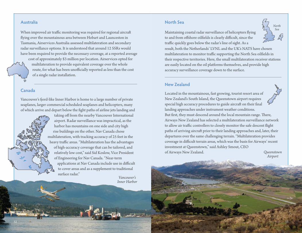
Vancouver’s fjord-like Inner Harbor is home to a large number of private seaplanes, larger commercial scheduled seaplanes and helicopters, many of which arrive and depart below the fight paths of airline jets landing and
taking off from the nearby Vancouver International airport. Radar surveillance was impractical, as the harbor has mountains on one side and city high
rise buildings on the other. Nav Canada chose multilateration, with tracking accuracy of 25 feet in the
heavy traffic areas. “Multilateration has the advantages of high-accuracy coverage that can be tailored, and relatively low cost,” said Sid Koslow, Vice President of Engineering for Nav Canada. “Near-term
applications at Nav Canada include use in difficult to cover areas and as a supplement to traditional surface radar.”
Maintaining coastal radar surveillance of helicopters flying to and from offshore oilfields is clearly difficult, since the traffic quickly goes below the radar’s line of sight. As a
When improved air traffic monitoring was required for regional aircraft flying over the mountainous area between Hobart and Launceston in Tasmania, Airservices Australia assessed multilateration and secondary radar surveillance options. It is understood that around 12 SSRs would have been required to provide the necessary coverage, at a reported average
cost of approximately $3 million per location. Airservices opted for multilateration to provide equivalent coverage over the whole route, for what has been unofficially reported as less than the cost of a single radar installation.
Located in the mountainous, fast growing, tourist resort area of New Zealand’s South Island, the Queenstown airport requires special high accuracy procedures to guide aircraft on their final landing approaches under instrument weather conditions. But first, they must descend around the local mountain range. There, Airways New Zealand has selected a multilateration surveillance network to allow air traffic controllers to closely monitor the safe descent flight paths of arriving aircraft prior to their landing approaches and, later, their departures over the same challenging terrain. “Multilateration provides coverage in difficult terrain areas, which was the basis for Airways’ recent investment at Queenstown,” said Ashley Smout, CEO of Airways New Zealand.
australia
Canada
north sea
new Zealand
North Sea
result, both the Netherlands’ LVNL and the UK’s NATS have chosen multilateration to monitor traffic supporting the North Sea oilfields in their respective territories. Here, the small multilateration receiver stations are easily located on the oil platforms themselves, and provide high accuracy surveillance coverage down to the surface.
32 33
Vancouver’s Inner Harbor
QueenstownAirport
34 multilateration & ads-b: executive reference guide worldwide adoption of multilateration 35
The rapid acceptance of multilateration is unprecedented in the history of air traffic control systems. However, it has also had the unprecedented effect of user demand outstripping the pace of traditional aviation rule making, just as the technology itself has, in many locations, outstripped the implementation of more costly, but less efficient, traditional aids, like secondary radar.
The good news is that leading ANSPs have demonstrated that it is not necessary to wait for traditional aviation rulemaking to catch up in order to realize the benefits of multilateration. They have shown that operational certification of MLAT-based applications is readily achievable today. Because it has been repeatedly proven by authorities that have certified MLAT performance to be equal to or better than SSR.
so how can multilateration be certified for civil aviation use today? Essentially, it is because national regulatory authorities agree that multilateration has demonstrated that it meets — and in many ways exceeds — all the certification criteria for secondary radar already specified by ICAO. In turn, this means that national regulators can certify the conformance of a multilateration installation against the established standards of the radar it is intended to replace. In no cases have multilateration systems been rejected by regulators for non-compliance with ICAO secondary radar standards.
are ICao standards being updated to formally recognize multilateration?
Yes. This process is well underway in ICAO’s Aeronautical Surveillance Panel (ASP) and its Separation and Airspace Safety Panel (SASP), both staffed by international surveillance specialists, with formal issue of ICAO
Standards And Recommended Practices (SARPS) expected within the next year. Parallel supporting activities are ongoing at Eurocontrol’s Multilateration Task Force, Eurocae’s WG70 and at ICAO regional meetings and individual ANSPs. Since multilateration’s current and future role is to supplement or replace secondary radar, it has been accepted that, following
the new “performance-based” philosophy, its characteristics must equal those of secondary surveillance radar. The approach being taken by ICAO and other groups is therefore to develop multilateration legislation to bring it into compliance with current ICAO secondary radar standards, reflecting the practice already adopted by national regulators.
Certification
Organization Description
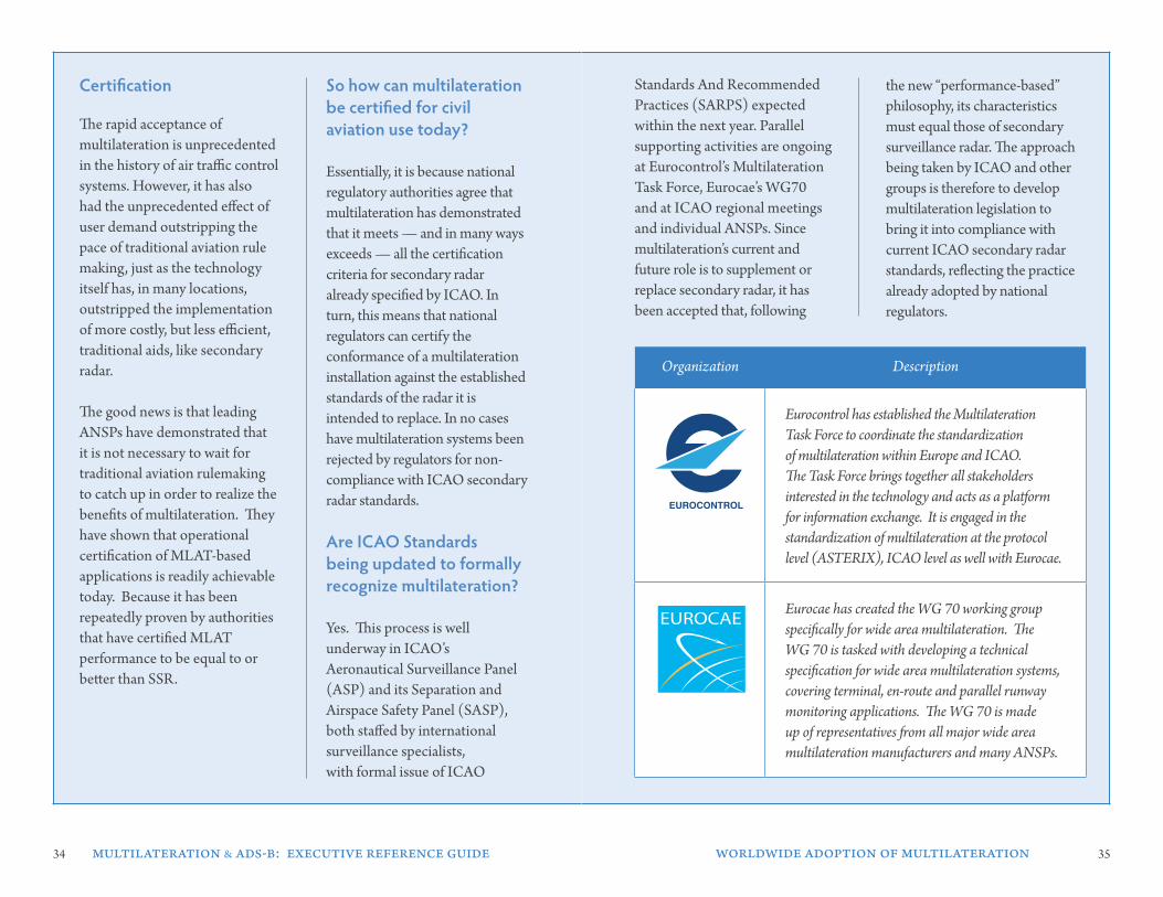
Eurocontrol has established the Multilateration Task Force to coordinate the standardization of multilateration within Europe and ICAO. The Task Force brings together all stakeholders interested in the technology and acts as a platform for information exchange. It is engaged in the standardization of multilateration at the protocol level (ASTERIX), ICAO level as well with Eurocae.
Eurocae has created the WG 70 working group specifically for wide area multilateration. The WG 70 is tasked with developing a technical specification for wide area multilateration systems, covering terminal, en-route and parallel runway monitoring applications. The WG 70 is made up of representatives from all major wide area multilateration manufacturers and many ANSPs.
36 multilateration & ads-b: executive reference guide ads-b and multilateration 37
ads-b and MulTIlaTeraTIon
In the future ADS-B environment, today’s secondary surveillance radars will essentially be decommissioned or become backup systems. ANSPs that have announced ADS-B programs, such as Airservices Australia and the FAA, have also stated their intention to correspondingly reduce their SSR installations by as much as 50 percent.
Many ANSPs are also considering multilateration as a more economical solution to future backup requirements, after analyzing the continuing costs of SSR maintenance, power, fuel and other expenditures.
Another key consideration is that multilateration systems have built-in ADS-B capabilities, with today’s ground-based multilateration sensors capable of tracking aircraft ADS-B transmissions as equally effective as those from Modes A, C, S and military IFF transponders.
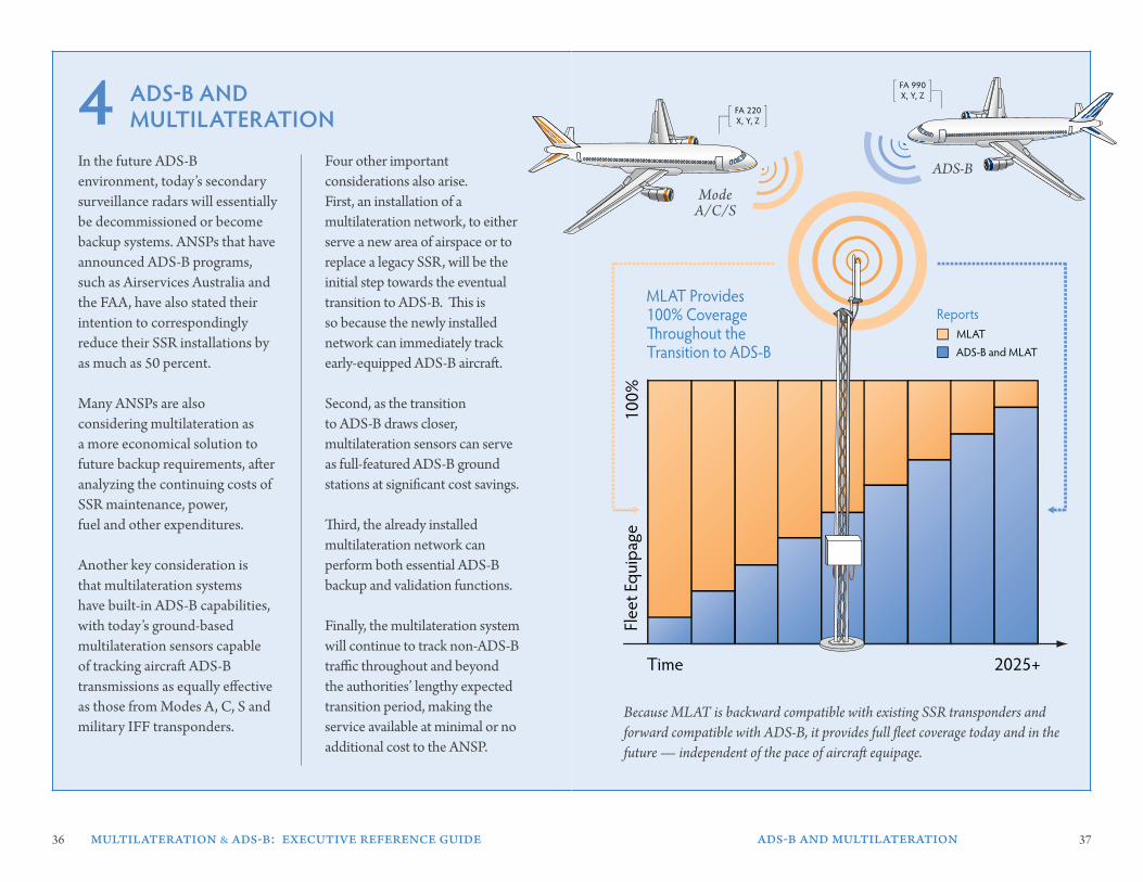
Four other important considerations also arise. First, an installation of a multilateration network, to either serve a new area of airspace or to replace a legacy SSR, will be the initial step towards the eventual transition to ADS-B. This is so because the newly installed network can immediately track early-equipped ADS-B aircraft.
Second, as the transition to ADS-B draws closer, multilateration sensors can serve as full-featured ADS-B ground stations at significant cost savings.
Third, the already installed multilateration network can perform both essential ADS-B backup and validation functions.
Finally, the multilateration system will continue to track non-ADS-B traffic throughout and beyond the authorities’ lengthy expected transition period, making the service available at minimal or no additional cost to the ANSP.
4
Because MLAT is backward compatible with existing SSR transponders and forward compatible with ADS-B, it provides full fleet coverage today and in the future — independent of the pace of aircraft equipage.
100%
2025+
MLAT Provides 100% Coverage �roughout theTransition to ADS-B
Time
FA 990X, Y, Z
FA 220X, Y, Z
ADS-B
ModeA/C/S
Flee
t Equ
ipag
e
MLATADS-B and MLAT
Reports
100%
2025+
MLAT Provides 100% Coverage �roughout theTransition to ADS-B
Time
FA 990X, Y, Z
FA 220X, Y, Z
ADS-B
ModeA/C/S
Flee
t Equ
ipag
e
MLATADS-B and MLAT
Reports
38 multilateration & ads-b: executive reference guide ads-b and multilateration 39
500 NM
450 NM
400 NM
350 NM
300 NM
250 NM
200 NM
150 NM
50 NM
100 NM
Sensors
ML
ADS-B
AT
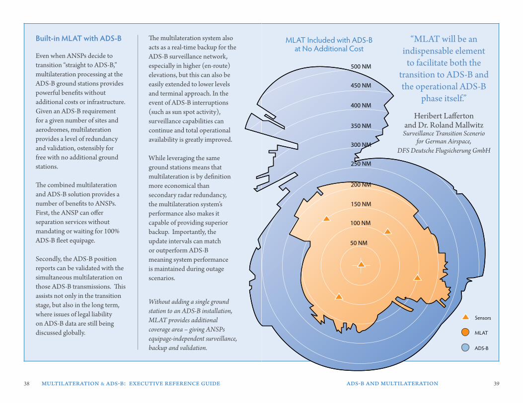
MLAT Included with ADS-B at No Additional Cost
“MLAT will be an indispensable element
to facilitate both the transition to ADS-B and the operational ADS-B
phase itself.”
Heribert Lafferton and Dr. Roland Mallwitz
Surveillance Transition Scenerio for German Airspace,
DFS Deutsche Flugsicherung GmbH
Even when ANSPs decide to transition “straight to ADS-B,” multilateration processing at the ADS-B ground stations provides powerful benefits without additional costs or infrastructure.Given an ADS-B requirement for a given number of sites and aerodromes, multilateration provides a level of redundancy and validation, ostensibly for free with no additional ground stations.
The combined multilateration and ADS-B solution provides a number of benefits to ANSPs. First, the ANSP can offer separation services without mandating or waiting for 100% ADS-B fleet equipage.
Secondly, the ADS-B position reports can be validated with the simultaneous multilateration on those ADS-B transmissions. This assists not only in the transition stage, but also in the long term, where issues of legal liability on ADS-B data are still being discussed globally.
The multilateration system also acts as a real-time backup for the ADS-B surveillance network, especially in higher (en-route) elevations, but this can also be easily extended to lower levels and terminal approach. In the event of ADS-B interruptions (such as sun spot activity), surveillance capabilities can continue and total operational availability is greatly improved.
While leveraging the same ground stations means that multilateration is by definition more economical than secondary radar redundancy, the multilateration system’s performance also makes it capable of providing superior backup. Importantly, the update intervals can match or outperform ADS-B meaning system performance is maintained during outage scenarios.
built-in MlaT with ads-b
Without adding a single ground station to an ADS-B installation, MLAT provides additional coverage area – giving ANSPs equipage-independent surveillance, backup and validation.
500 NM
450 NM
400 NM
350 NM
300 NM
250 NM
200 NM
150 NM
50 NM
100 NM
Sensors
ML
ADS-B
AT
MLAT Included with ADS-B at No Additional Cost
40 multilateration & ads-b: executive reference guide benefits of multilateration 41
beneFITs oF MulTIlaTeraTIon
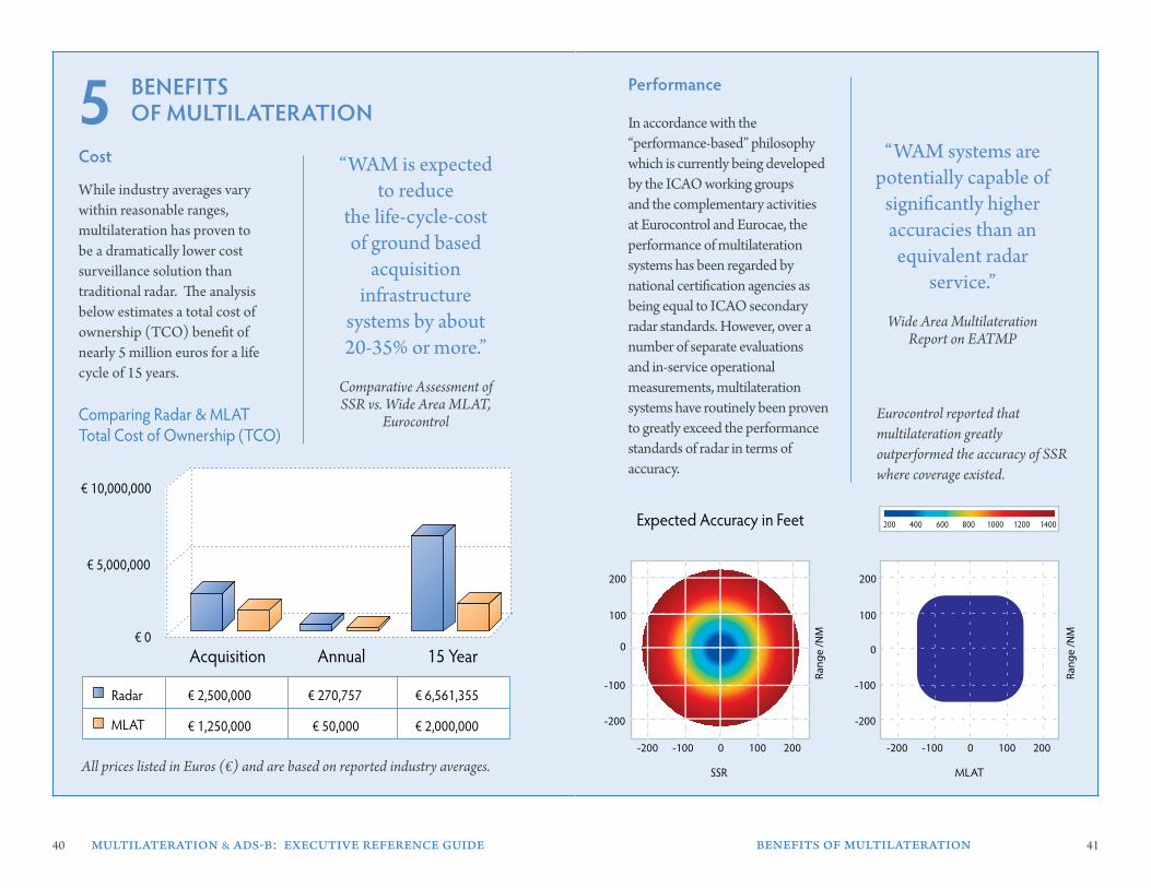
Cost
While industry averages vary within reasonable ranges, multilateration has proven to be a dramatically lower cost surveillance solution than traditional radar. The analysis below estimates a total cost of ownership (TCO) benefit of nearly 5 million euros for a life cycle of 15 years.
“WAM is expected to reduce
the life-cycle-cost of ground based
acquisition infrastructure
systems by about 20-35% or more.”
Comparative Assessment of SSR vs. Wide Area MLAT,
Eurocontrol
5“WAM systems are
potentially capable of significantly higher accuracies than an
equivalent radar service.”
Wide Area Multilateration Report on EATMP
In accordance with the “performance-based” philosophy which is currently being developed by the ICAO working groups and the complementary activities at Eurocontrol and Eurocae, the performance of multilateration systems has been regarded by national certification agencies as being equal to ICAO secondary radar standards. However, over a number of separate evaluations and in-service operational measurements, multilateration systems have routinely been proven to greatly exceed the performance standards of radar in terms of accuracy.
Performance
Eurocontrol reported that multilateration greatly outperformed the accuracy of SSR where coverage existed.
200 400 600 800 1000 1200 1400
0
200
100
-100
-200
2001000-100-200
Ran
ge
/NM
SSR
0
200
100
-100
-200
2001000-100-200
Ran
ge
/NM
MLAT
Expected Accuracy in Feet
Acquisition Annual 15 Year
€ 10,000,000
€ 5,000,000
€ 0
Radar
MLAT
€ 2,500,000
€ 1,250,000
€ 270,757
€ 50,000
€ 6,561,355
€ 2,000,000
Comparing Radar & MLAT Total Cost of Ownership (TCO)
All prices listed in Euros (€) and are based on reported industry averages.
42 multilateration & ads-b: executive reference guide benefits of multilateration 43
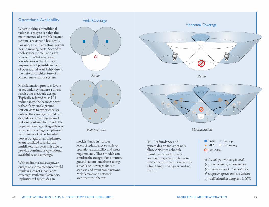
operational availability
A site outage, whether planned (e.g. maintenance) or unplanned (e.g. power outage), demonstrates the superior operational availability of multilateration compared to SSR.
models “build-in” various levels of redundancy to achieve operational availability and safety requirements. These models can simulate the outage of one or more ground stations and the resulting surveillance coverage for each scenario and event combinations. Multilateration’s network architecture, inherent
“N-1” redundancy and system design tools not only allow ANSPs to schedule maintenance without any coverage degradation, but also dramatically improve availability when things don’t go according to plan.
Radar
Multilateration
Radar
Multilateration
When looking at traditional radar, it is easy to see that the maintenance of a multilateration system is easier and less costly.For one, a multilateration system has no moving parts. Secondly, each sensor is small and easy to reach. What may seem less obvious is the dramatic improvement possible in terms of operational availability due to the network architecture of an MLAT surveillance system.
Multilateration provides levels of redundancy that are a direct result of its network design. Typically referred to as N-1 redundancy, the basic concept is that if any single ground station were to experience an outage, the coverage would not degrade as remaining ground stations continue to provide the required coverage. Regardless of whether the outage is a planned maintenance task, scheduled power outage, or an unplanned event localized to a site, the multilateration system is able to provide continuous operational availability and coverage.
With traditional radar, a power outage or site maintenance would result in a loss of surveillance coverage. With multilateration, sophisticated system design
No CoverageRadar CoverageMLAT
Aerial CoverageHorizontal Coverage
Site Outage
No CoverageRadar CoverageMLAT
Aerial CoverageHorizontal Coverage
Site Outage
44 multilateration & ads-b: executive reference guide benefits of multilateration 45
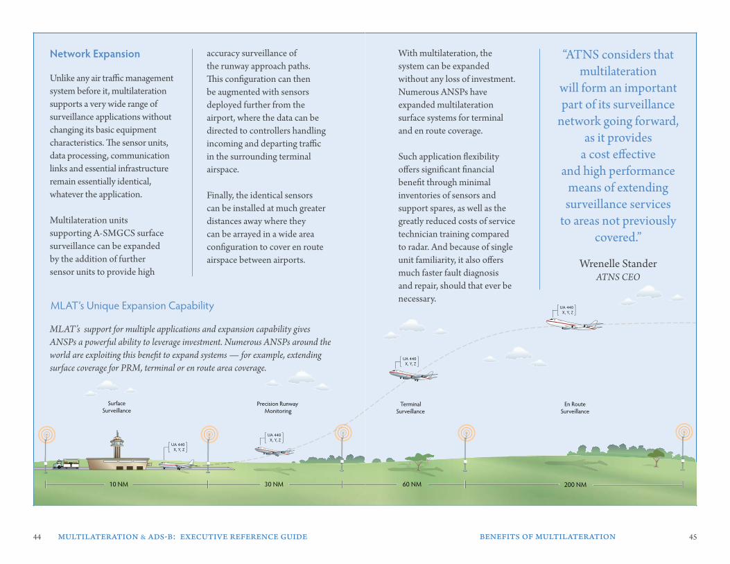
Unlike any air traffic management system before it, multilateration supports a very wide range of surveillance applications without changing its basic equipment characteristics. The sensor units, data processing, communication links and essential infrastructure remain essentially identical, whatever the application.
Multilateration units supporting A-SMGCS surface surveillance can be expanded by the addition of further sensor units to provide high
network expansion accuracy surveillance of the runway approach paths. This configuration can then be augmented with sensors deployed further from the airport, where the data can be directed to controllers handling incoming and departing traffic in the surrounding terminal airspace.
Finally, the identical sensors can be installed at much greater distances away where they can be arrayed in a wide area configuration to cover en route airspace between airports.
MLAT’s support for multiple applications and expansion capability gives ANSPs a powerful ability to leverage investment. Numerous ANSPs around the world are exploiting this benefit to expand systems — for example, extending surface coverage for PRM, terminal or en route area coverage.
With multilateration, the system can be expanded without any loss of investment. Numerous ANSPs have expanded multilateration surface systems for terminal and en route coverage.
Such application flexibility offers significant financial benefit through minimal inventories of sensors and support spares, as well as the greatly reduced costs of service technician training compared to radar. And because of single unit familiarity, it also offers much faster fault diagnosis and repair, should that ever be necessary.
“ATNS considers that multilateration
will form an important part of its surveillance
network going forward, as it provides
a cost effective and high performance
means of extending surveillance services
to areas not previously covered.”
Wrenelle StanderATNS CEO
MLAT’s Unique Expansion Capability
Precision Runway Monitoring
SurfaceSurveillance
Terminal Surveillance
En RouteSurveillance
10 NM 30 NM 60 NM 200 NM
UA 440X, Y, Z
UA 440X, Y, Z
UA 440X, Y, Z
UA 440X, Y, Z
Precision Runway Monitoring
SurfaceSurveillance
Terminal Surveillance
En RouteSurveillance
10 NM 30 NM 60 NM 200 NM
UA 440X, Y, Z
UA 440X, Y, Z
UA 440X, Y, Z
UA 440X, Y, Z
46 47
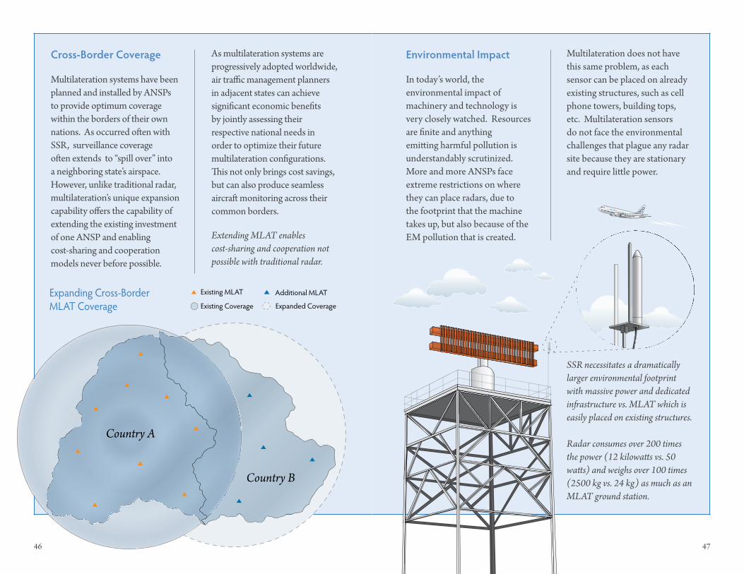
Multilateration systems have been planned and installed by ANSPs to provide optimum coverage within the borders of their own nations. As occurred often with SSR, surveillance coverage often extends to “spill over” into a neighboring state’s airspace. However, unlike traditional radar, multilateration’s unique expansion capability offers the capability of extending the existing investment of one ANSP and enabling cost-sharing and cooperation models never before possible.
As multilateration systems are progressively adopted worldwide, air traffic management planners in adjacent states can achieve significant economic benefits by jointly assessing their respective national needs in order to optimize their future multilateration configurations. This not only brings cost savings, but can also produce seamless aircraft monitoring across their common borders.
Cross-border Coverage
In today’s world, the environmental impact of machinery and technology is very closely watched. Resources are finite and anything emitting harmful pollution is understandably scrutinized. More and more ANSPs face extreme restrictions on where they can place radars, due to the footprint that the machine takes up, but also because of the EM pollution that is created.
environmental Impact Multilateration does not have this same problem, as each sensor can be placed on already existing structures, such as cell phone towers, building tops, etc. Multilateration sensors do not face the environmental challenges that plague any radar site because they are stationary and require little power.
SSR necessitates a dramatically larger environmental footprint with massive power and dedicated infrastructure vs. MLAT which is easily placed on existing structures.
Radar consumes over 200 times the power (12 kilowatts vs. 50 watts) and weighs over 100 times (2500 kg vs. 24 kg) as much as an MLAT ground station.
Extending MLAT enables cost-sharing and cooperation not possible with traditional radar.
Country B
Country A
Expanded Coverage
Additional MLAT
Existing Coverage
Existing MLATExpanding Cross-Border MLAT Coverage
48 multilateration & ads-b: executive reference guide
FurTHer readInG & resourCes
Papers
Wide Area Multilateration, Report on EATMP TRS 131/04, Version 1.1, Eurocontrol. W.H.L. Neven, T.J. Quilter, R. Weedon, and R.A. Hogendoorn. August 2005.
Surveillance Transition Scenario for German Airspace. Results of the DFS ADS-B Study Group. DFS Deutsche Flugsicherung GmbH. Heribert Lafferton, Dr. Roland Mallwitz. January 31, 2007.
Comparative Assessment of SSR vs. Wide Area Multi-LaterationEurocontrol. Edition 1.3. September 29, 2005.
Generic Safety Assessment for ATC Surveillance using Wide Area Multilateration. Helios Technology. Nick McFarlane.
WAM Safety Study & Surveillance Generic Safety.Eurocontrol. Bob Darby. November 9, 2007.
The ATM Target Concept D3.Eurocontrol. SESAR Consortium. September 2007.
ATM Deployment Sequence D4.Eurocontrol. SESAR Consortium. 2007.
articles
MLAT Systems Gain Ground Jane’s AIRPORT REVIEW. March, 2007. Volume 19. Issue 2. Page 20.
Multilateration: Radar’s Replacement? Avionics. Callan James. April, 2007. Pages 30-34.
Multilateration: The Challenges Ahead. Air Traffic Management. Issue 2, 2007. Pages 26-29.
Multilateration Technology is Well Suited to a Wide Range of Applica-tions. ICAO Journal. Volume 62. Number 3, 2007. Pages 12-14, 32-33.
Life After Radar. Air Traffic Manage-ment. Issue 2, 2007. Pages 18-24.
organizations
Eurocontrol Multilateration Task Force, www.eurocontrol.int
Eurocae WG-70: Multillateration Working Group, www.eurocae.eu
International Civil Aviation Organization (ICAO), www.icao.int
Civil Air Navigation Services Organ-isation (CANSO), www.canso.org
International Cooperation on Airport Surveillance, www.icas-group.org