Muldrew Barrens Conservation Reserve (C310) Statement...
25
Muldrew Barrens Conservation Reserve (C310) Statement of Conservation Interest March 2004
Transcript of Muldrew Barrens Conservation Reserve (C310) Statement...

Muldrew Barrens Conservation Reserve (C310)
Statement of Conservation Interest March 2004

i
Muldrew Barrens Conservation Reserve
(C310)
Statement of Conservation Interest
Ministry of Natural Resources Parry Sound District
Prepared with the assistance of: Meteek & Company Huntsville, Ontario
March 2004

ii
Approval Statement We are pleased to approve this Statement of Conservation Interest for Muldrew Barrens Conservation Reserve (C310). Muldrew Barrens Conservation Reserve consists of 803 hectares of Crown land. This site is located about 4 kilometres south of downtown Gravenhurst. It is located in Morrison and Muskoka Wards, in the Town of Gravenhurst, in the District Municipality of Muskoka. It is about 1 kilometre southeast of Loon Lake Wetland Conservation Reserve and about 1 kilometre west of Jevins and Silver Lake Conservation Reserve. It is surrounded almost entirely by privately owned lands, which are not part of the conservation reserve. This site provides a representative landscape of the Muskoka portion of the southern Canadian Shield area in ecological Site District 5E-7. The conservation reserve includes a mosaic of upland rocky ridges and long shallow depressions filled with water. Much of the topography of the site has an orientation running northwest to southeast with upland areas of water-smoothed bedrock and discontinuous water filled depression. The site has numerous ponds and wetland areas that include typical aquatic vegetation. Recent evaluation has identified three of these wetland areas assessed as being “High Potential Wetland Complexes” with potential to be identified as provincially significant wetlands. Muldrew Barrens Conservation Reserve is one of 378 new protected areas approved through Ontario’s Living Legacy Land Use Strategy, aimed, in part, at completing Ontario’s system of parks and protected areas. During the “Lands for Life” planning process, the public was widely consulted and provided valuable input into what became Ontario’s Living Legacy Land Use Strategy. Comments received during that time, and during consultation related to the formal Public Lands Act regulation of the boundaries of this conservation reserve, were generally supportive of the protection of this area. Stakeholders who provided comment during the earlier consultation for this site were subsequently consulted regarding the draft Statement of Conservation Interest and their comments were considered in the finalization of this document. This Statement of Conservation Interest provides guidance for the management of the conservation reserve and provides the basis for the ongoing monitoring of activities. More detailed direction is not anticipated at this time. Should more complex resource management or conservation issues arise or significant facility development be considered, then a detailed Resource Management Plan will be prepared with full public consultation. Muldrew Barrens Conservation Reserve is managed under the direction of the District Manager and the Bracebridge Area Supervisor of the Ministry of Natural Resources, Parry Sound District. Approved by: R. Griffiths
District Manager Parry Sound District
Approved by: Ron Running
Regional Director Southern Region

iii
Table of Contents APPROVAL STATEMENT ....................................................................................................................... II
1.0 INTRODUCTION ................................ ................................ ................................ ............................3
1.1 BACKGROUND INFORMATION: ...............................................................................................................3 1.2 REPRESENTATION ..............................................................................................................................4 1.3 SURVEY WORK ..................................................................................................................................4
2.0 VALUES TO BE PROTECTED .......................................................................................................5
2.1 EARTH SCIENCE:................................................................................................................................5 2.2 LIFE SCIENCE: ...................................................................................................................................5 2.3 CULTURAL VALUES: ................................ ................................ ................................ ............................7 2.4 RECREATIONAL/AESTHETIC VALUES:.....................................................................................................7
3.0 MANAGEMENT GUIDELINES ........................................................................................................8
3.1 LAND TENURE: ..................................................................................................................................8 3.2 DEVELOPMENT: .................................................................................................................................8 3.3 RECREATIONAL ACTIVITIES : .................................................................................................................9 3.4 COMMERCIAL ACTIVITIES: ................................ ................................ ................................ ..................10 3.5 ABORIGINAL INTERESTS: ...................................................................................................................10 3.6 NATURAL RESOURCE STEWARDSHIP: ................................ ................................ ................................ ..11 3.7 CULTURAL RESOURCE STEWARDSHIP: ................................................................................................12 3.8 CLIENT SERVICES: ...........................................................................................................................12 3.9 RESEARCH: .....................................................................................................................................13 3.10 MARKETING: ................................ ................................ ................................ ................................ ..13
4.0 IMPLEMENTATION......................................................................................................................13
5.0 REVIEW AND REVISION OF THE STATEMENT OF CONSERVATION INTEREST ........................14
6.0 REFERENCES .............................................................................................................................15
APPENDICES ........................................................................................................................................16
APPENDIX 1 PROCEDURAL GUIDELINE B – LAND USES – ................................ ................................ ..........16 APPENDIX 2 INDICATOR USES FOR CONSERVATION RESERVES: .................................................................17 APPENDIX 3 PROCEDURAL GUIDELINE C ................................................................................................19
Table of Figures Figure 1: Location of Muldrew Barrens Conservation Reserve (C310) ...................................................1 Figure 2: Site Map – Muldrew Barrens Conservation Reserve (C310) .....................................................2

1
Figure 1: Location of Muldrew Barrens Conservation Reserve

2
Figure 2: Site Map – Muldrew Barrens Conservation Reserve

3
1.0 Introduction Ontario’s Living Legacy, the result of an extensive planning process that began in early 1997, culminated in the approval in July 1999 of a Land Use Strategy that identifies the intended strategic direction for Crown land, including the completion of Ontario’s system of parks and protected areas. This process, which included extensive public consultation, resulted in the recommendation for regulation of 378 new protected areas, including Muldrew Barrens Conservation Reserve (C310). Muldrew Barrens Conservation Reserve consists of 803 hectares of Crown land, located 4 kilometres south of downtown Gravenhurst. It is located in Morrison and Muskoka Wards, in the Town of Gravenhurst, in the District Municipality of Muskoka. It is surrounded almost entirely by privately owned lands, which are not part of the conservation reserve. The conservation reserve, lying within the ecological Site District 5E-7, includes a mosaic of upland rocky ridges and long shallow depressions filled with water. The upland areas typically have scrubby stunted flora, while the low lying wet areas have representative aquatic vegetation and associated boggy conditions. The exposed bedrock with its uniform ”scarp and dip” topography characterizes the Muldrew Barrens as a whole. Scarp slopes face towards the southwest, while dip slopes face towards the northeast, and a multitude of small lakes and ponds lie in hollows created between the successive scarps. This conservation reserve offers one of the better examples of scarp and dip topography in Ontario’s protected areas system. For this reason, it is considered of provincial significance. The site is generally recognized as providing wilderness-type recreation opportunities. It is known to accommodate snowshoeing, cross country skiing, hiking, viewing, orienteering, tobogganing and blueberry picking. Conservation reserves are established under the authority of the Public Lands Act, Ontario Regulation 805/94. Muldrew Barrens Conservation Reserve was established by Ontario Regulation 148/02 on May 8, 2002. A Statement of Conservation Interest (SCI) is prepared under the direction of Procedural Guideline A – Resource Management Planning (PL. Procedure 3.03.05). The purpose of this SCI is to identify and describe the values of Muldrew Barrens Conservation Reserve. The SCI also outlines the activities that currently occur within the conservation reserve and provides guidelines for the management of current and future activities in the context of protecting the natural, recreational and cultural values. 1.1 Background Information:
Name
Muldrew Barrens Conservation Reserve (C310)
Site Region/District Georgian Bay 5E-7
OMNR Administrative Region/District/Area Southern Region/Parry Sound District/ Bracebridge Area
Total Area (ha.) 803 hectares
Regulation Date May 8, 2002 (O. Reg. 148/02)
First Nations Robinson-Huron Treaty and Williams Treaty
OBM map sheets 10 17 6250 49650, 6250 49700
4
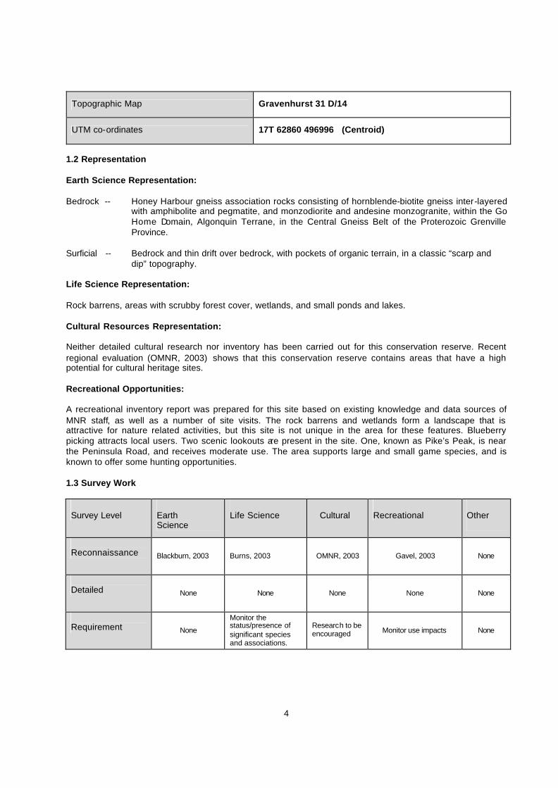
Topographic Map Gravenhurst 31 D/14
UTM co-ordinates 17T 62860 496996 (Centroid)
1.2 Representation Earth Science Representation: Bedrock -- Honey Harbour gneiss association rocks consisting of hornblende-biotite gneiss inter-layered
with amphibolite and pegmatite, and monzodiorite and andesine monzogranite, within the Go Home Domain, Algonquin Terrane, in the Central Gneiss Belt of the Proterozoic Grenville Province.
Surficial -- Bedrock and thin drift over bedrock, with pockets of organic terrain, in a classic “scarp and
dip” topography. Life Science Representation: Rock barrens, areas with scrubby forest cover, wetlands, and small ponds and lakes. Cultural Resources Representation: Neither detailed cultural research nor inventory has been carried out for this conservation reserve. Recent regional evaluation (OMNR, 2003) shows that this conservation reserve contains areas that have a high potential for cultural heritage sites. Recreational Opportunities: A recreational inventory report was prepared for this site based on existing knowledge and data sources of MNR staff, as well as a number of site visits. The rock barrens and wetlands form a landscape that is attractive for nature related activities, but this site is not unique in the area for these features. Blueberry picking attracts local users. Two scenic lookouts are present in the site. One, known as Pike’s Peak, is near the Peninsula Road, and receives moderate use. The area supports large and small game species, and is known to offer some hunting opportunities. 1.3 Survey Work Survey Level
Earth Science
Life Science
Cultural
Recreational
Other
Reconnaissance Blackburn, 2003 Burns, 2003 OMNR, 2003 Gavel, 2003 None
Detailed None None None None None
Requirement None
Monitor the status/presence of significant species and associations.
Research to be encouraged Monitor use impacts None
5
2.0 Values to be protected The conservation reserve is located entirely within Hills’ (1959) ecological Site District 5E-7. Values include earth science, life science and recreational/aesthetic values, with an emphasis on the life sciences. 2.1 Earth Science: (Earth science information, unless otherwise noted, is taken from Blackburn, 2003) Bedrock: Muldrew Barrens Conservation Reserve lies within the Go Home Domain, Algonquin Terrane, in the Central Gneiss Belt of the Proterozoic Grenville Province (Easton, 1992a, b).
The Algonquin Terrane is one of four lithotectonic terranes of the Central Gneiss Belt. Within the Algonquin Terrane, the Go Home Domain is one of twelve structural domains. The Go Home Domain consists of highly deformed 1.8 to 1.6 billion-year-old gneisses and migmatites of supracrustal and igneous origin that have been intruded by younger (1.5 to 1.4 billion-year-old) granitic and monzonitic plutons. This Domain is divided into two gneiss associations. One of these is represented in this conservation reserve. The Honey Harbour gneiss association is largely a uniform, granoblastic, migmatitic, pink granitic or grey granodiorite gneiss. (Easton, 1992a). The Honey Harbour gneisses are intruded by younger granitic plutons, collectively called the Go Home Complex. These plutons have folded along with the gneisses around major fold structures. The Grenville Province is the product of thrusting and imbrication of the crust to the northwest as it collided with a continental landmass to the southeast. The Grenville Orogeny, circa 1140 to 1070 million years ago, culminated more than 500 million years of crustal evolution. The eroded roots of the products of these events are displayed in the complexly metamorphosed and deformed rocks of the region (Easton, 1992b). This geological environment is part of the modern organization of the complex products of the mid-Proterozoic Grenville orogenic events (Easton, 1992a and b). As such, its representation in Muldrew Barrens Conservation Reserve contributes to the conservation of the Grenville continental accretion theme outlined by Davidson (1981). The rocks of the Honey Harbour gneiss association that underlie this entire site are well exposed and possibly the best representation of this unit of the Go Home Domain within any conservation reserve lands. These bedrock geological features have regional significance in their contribution to the understanding of the history of development of the Proterozoic Grenville Province. Surficial: Muldrew Barrens Conservation Reserve is an area of exposed bedrock, and thin drift over bedrock, with pockets of organic terrain. Erosion of the gneisses of the Honey Harbour association, with their uniform strike, have imparted a ”scarp and dip” topography characteristic of the Muldrew Barrens as a whole. Scarp slopes face towards the southwest, while dip slopes face towards the northeast, and a multitude of small lakes and ponds lie in hollows created between the successive scarps. The influence of bedrock structure on subsequent physiography is well represented in this conservation reserve, and is one of the better examples of scarp and dip topography in Ontario’s protected areas system. For this reason, it is considered of provincial significance. 2.2 Life Science: (Life science information, unless otherwise noted, is taken from Burns, 2003) The conservation reserve is located within Hills’ (1959) ecological Site District 5E-7. Life science significance is determined on the basis of the following criteria: representation, diversity, condition, ecological considerations and special features (Crins and Kor, 1998).

6
Representation: Muldrew Barrens Conservation Reserve includes a mosaic of upland rocky ridges and long shallow depressions filled with water within the ecological Site District 5E-7. This Site District is characterized by an assortment of weakly broken plains and moderately broken uplands of smooth gneissic bedrock with areas of sandy till, silts, and clays. Predominant, and found throughout the conservation reserve, is landform unit (VIIa-7), a weakly broken bare bedrock plain. Much of the area has an approximately north-south lineal appearance with upland areas of water-smoothed bedrock and discontinuous water-filled depressions. Water accumulates in these depressions and its retention is aided in part by extensive beaver activity. The upland areas typically have scrubby stunted flora, while the low lying wet areas have representative aquatic vegetation and associated boggy conditions. The area contains a few southern species such as white oak (Quercus alba) which Noble (1983) indicated are at the northern limit of their range. The upland rocky sites within the conservation reserve consist of scrubby white oak (Quercus alba), white pine (Pinus strobus), juniper (Juniperus communis), mountain ash (Sorbus sp.), smooth and velvet-leaf blueberry (Vaccinium sp.), bracken fern (Pteridium aquilinum), common polypody fern (Polypodium virginianum ), aster (Aster sp.), wild sarsaparilla (Aralia nudicaulis), wintergreen (Gaultheria sp. ), blackberry (Rubus sp.) and sweet fern (Comptonia peregrina). There are also patches of lichen (Cladina sp., Stereocaulon tomentosum, Umbilicaria mammulata), and mosses, haircap moss (Polytrichum sp.), dicranum mosses (Dicranum sp.) and sphagnum mosses (Sphagnum sp. ). The lowland hardwood sites have forest communities dominated by sugar maple (Acer saccharum ), red maple (Acer rubrum ), black ash (Fraxinus nigra), basswood (Tilia americana) and white birch (Betula papyrifera). The understorey contains striped maple (Acer pensylvanicum), mountain maple (Acer spicatum ), beaked hazel (Corylus cornuta), wild sarsaparilla (Aralia nudicaulis), cinnamon fern (Osmunda cinnamomea), sensitive fern (Onoclea sensibilis), and large leaf aster (Aster macrophyllus). The conservation reserve has within its boundaries numerous ponds and low saturated areas that include aquatic vegetation typical to wetland areas. Yellow water lily (Nuphar variegatum), water shield (Brasenia schreberi), leatherleaf (Chamaedaphne calyculata), bog laurel (Kalmia polifolia), bog rosemary (Andromeda polifolia spp.glaucophylla), sweet gale (Myrica gale), sphagnum mosses (Sphagnum sp.), tamarack (Larix laricina), black spruce (Picea mariana), red maple (Acer rubrum), and large cranberry (Vaccinium macrocarpon) are some of the most numerous species in the low lying areas. Condition: Muldrew Barrens Conservation Reserve shows little in the way of disturbance or anthropogenic impact. Peninsula Road crosses the northwest extension of this site, and Highway 11 borders its east side. Parallel to Highway 11, and close to it, a railway line crosses through the eastern limits of this site. Otherwise there are no developed roads or trails within the site. Diversity: Muldrew Barrens Conservation Reserve offers a mix of upland rocky areas, water-filled wetland areas and a small amount of lowland hardwood forest. The forest stand types, ecosites and water areas are arranged in a longitudinal fashion extending northwest to southeast, consistent with the underlying geologic features. The forest ecosystem classification guide was used to describe the life science values present at the site. Ecosites describe mapping units that represent a consistent set of vegetation and site conditions (Chambers et. al., 1997). There are 4 forested ecosites within the conservation reserve which constitute 46.4% (378 hectares of the land base, and 1 non-forested ecosite (primarily rock) which represents 42.9% (349 hectares) of the land base. The remaining 10.7% (87 hectares) consists of small lakes and ponds.

7
Ecological Considerations Muldrew Barrens Conservation Reserve offers a unique and diverse protected area. The numerous small ponds offer shallow open water and wetland areas for nesting and migratory waterfowl. They also serve as an important habitat and food source for many small mammals. There are potential anthropogenic impacts because of adjacent land use. Special Features Three of the wetland complexes on this site (particularly in the eastern side) have been identified as having the potential of being provincially significant wetlands, through the use of satellite imagery and other available wetlands information (Ducks Unlimited Canada and OMNR, 2003). 2.3 Cultural Values: No specific cultural studies or inventories have been undertaken within the conservation reserve, and no major cultural resource values have been evaluated or identified to date. Recent regional evaluation (OMNR, 2003) shows that this conservation reserve contains areas that have a high potential for cultural heritage sites. Allen (2001 and 2004) points out that this site lies close to a former First Nations travel corridor between the Severn watershed and the Muskoka watershed. 2.4 Recreational/Aesthetic Values: The site is generally recognized as providing wilderness-type recreation opportunities. It may accommodate big game hunting, and has limited potential for fishing. It is known to accommodate snowshoeing, cross country skiing, hiking, viewing, orienteering, tobogganing and blueberry picking. There are no Crown land recreational camps or authorized trails (motorized or walking) within the conservation reserve. There is road access to the extreme northwestern and eastern parts of the conservation reserve. Access to the northwestern part of the conservation reserve is by way of a municipal, year round maintained road called Peninsula Road. This road bisects the northern parts of Lots 28 and 29, Concession 1, Muskoka Ward. There is a cleared, flat area on the right of way where people have been parking vehicles while visiting the conservation reserve. Access to the extreme eastern portion of the conservation reserve is by way of Provincial Highway 11. However the Canadian National Railway right-of-way that crosses the eastern portion of the conservation reserve obstructs legal access to the conservation reserve from the east. Pikes Peak (a local name) is situated on the north side of Peninsula Road, just north of a parking lot. It is the highest point of land in the northern section of the conservation reserve and provides a pleasant viewing opportunity (Viejou, 2003). There is a slightly higher peak located on Lot 26, Concession 12, Morrison Ward that also provides a pleasant viewing opportunity. There is a constriction between the two wetlands just east of Middle Muldrew Lake (southwest corner of Lot 29, Concession 1, Muskoka Ward) that is used for tobogganing and is locally known as Devil’s Gulch. The 50 foot high sloping cliff faces the east pond providing a fast relatively safe ride (Viejou, 2003). While this site is close to the Gravenhurst town centre and other private land cottage development on nearby lakes, the distance from major urban development has resulted in a relatively pristine night sky, which enhances the sense of remoteness and wilderness of this site. Pristine night skies are considered a significant value, given the increasingly limited areas of southern and central Ontario which are not heavily affected by light pollution.

8
3.0 Management Guidelines 3.1 Land Tenure: Background: Muldrew Barrens Conservation Reserve comprises 803 hectares of Crown land. It is almost totally surrounded by private land. There is no intent to acquire adjacent private lands for addition to the conservation reserve. The municipal road allowances are under the jurisdiction of the local municipality, and are not a part of the conservation reserve. Peninsula Road and the Canadian National Railbed are also excluded from the conservation reserve. There are no Bear Management Areas in the vicinity of the conservation reserve. It occupies portions of two Bait Fish Blocks (PS0240 & PS0249). It is not within a registered trapline area; however, resident trappers may be licensed to trap within and around the site. One resident trapper has land allocations within the boundaries of the conservation reserve. There are no authorized recreation camps within this site. Guideline: The sale of Crown lands within the conservation reserve is generally not permitted. Exceptions will only be considered under unusual circumstances, such as where an adjacent privately owned parcel has inadequate area for the installation of a septic system. This situation is unlikely to occur in this conservation reserve. There are no plans by the MNR to acquire private lands to add to the conservation reserve Fur harvest is permitted to continue under the authority of resident trapping licences. The Bait Fish Blocks, currently assigned, are permitted to continue. Since there is no surrounding Bear Management Area, commercial bear hunting services are not allowed within the boundaries of this conservation reserve, and additional areas of the conservation reserve cannot be incorporat ed into any future Bear Management Area. New recreation camps are not permitted in this conservation reserve. 3.2 Development: Background: There are no Crown owned buildings or other facilities within the conservation reserve. There is one road crossing the north-west corner of the conservation reserve. Peninsula Road provides access through the site to North Muldrew Lake and Middle Muldrew Lake. The road allowance for this road, and other unopened road allowances are under municipal jurisdiction, and are not included as a part of the conservation reserve. Guideline: New roads for resource extraction and/or private use will not be permitted, nor will additions to existing roads, or up-grading of existing roads be permitted. There is no intention to develop roads outside of the conservation reserve to improve access to this site. Unauthorized works within the conservation reserve will be handled in accordance with the Public Lands Act, and any required removal of improvements will be at the expense of those responsible. New recreational trails may be considered on a case by case basis provided that they meet Procedural Guideline B – Land Uses – Test of Compatibility (see Appendix 1) and the MNR's Environmental Assessment

9
Act requirements. Public consultation will generally be required during the consideration of changes to existing trails, and will always be required for new trails. New recreational trails will not be permitted in or within 120 metres of the wetlands that have been assessed as having high potential to be provincially significant wetlands unless it has been demonstrated that there will be no negative impacts on the natural features or the ecological functions of the wetland. New recreational trails for motorized vehicles will not be permitted, unless the following have been demonstrated:
• there is a community need for the trail, as well as community support; • there are no alternative suitable locations outside the conservation reserve; • the trail location would be acceptable and suitable for four-season use; • the trail would meet the requirements applicable to all trails, as identified in the preceding paragraph.
No mineral exploration is permitted within this conservation reserve. This policy direction is based on a commitment made by the Ministry of Natural Resources and the Ministry of Northern Development and Mines in March, 2002. This direction replaces that identified in the 1999 Ontario’s Living Legacy Land Use Strategy (OMNR, 1999), which stated that controlled mineral exploration would be permitted in new conservation reserves which were identified as having provincially significant mineral potential. Any new development must meet MNR’s commitments to protect cultural heritage values (see Section 3.7). While there is no intent at present to provide or permit any new development in this conservation reserve that would require lighting, should this be considered at some point in the future the MNR will not allow unnecessary, undirected light pollution. This commitment recognizes the wilderness values provided by a pristine night sky. 3.3 Recreational Activities: Background: The site is generally recognized as providing wilderness-type recreation opportunities. It may accommodate big game hunting, and has limited potential for fishing. It is known to accommodate snowshoeing, cross country skiing, hiking, viewing, orienteering, tobogganing and blueberry picking. There are no Crown land recreational camps or authorized trails (motorized or walking) within the conservation reserve. There is little evidence of use by snowmobiles or all-terrain vehicles on this site. The rock barren areas may not be subject to major impact, but adjacent wetlands are particularly sensitive to use by all-terrain vehicles. Guideline: Hunting and fishing are permitted to continue within the conservation reserve. Recreational use such as hiking, wildlife viewing, snowshoeing, and cross-country skiing will be allowed to occur in the conservation reserve. The use of the site by snowmobiles and all-terrain vehicles will be monitored to ensure that the conservation reserve values are not being adversely impacted. As discussed in Section 3.2 Development, new recreational trails may be considered on a case by case basis provided that they meet Procedural Guideline B – Land Uses – Test of Compatibility (see Appendix 1) and the MNR's Environmental Assessment Act requirements. Public consultation will generally be required during the consideration of changes to existing trails, and will always be required for new trails. New recreational trails will not be permitted in or within 120 metres of the wetlands that have been assessed as having high potential to be provincially significant wetlands unless it has been demonstrated that there will be no negative impacts on the natural features or the ecological functions of the wetland. Any new trails must meet MNR’s commitments to protect cultural heritage values (see Section 3.7).

10
New recreational trails for motorized vehicles will not be permitted, unless the following have been demonstrated:
• there is a community need for the trail, as well as community support; • there are no alternative suitable locations outside the conservation reserve; • the trail location would be acceptable and suitable for four-season use; • the trail would meet the requirements applicable to all trails, as identified in the preceding paragraph.
Off-trail use of snowmobiles and all-terrain vehicles is only permitted for the direct retrieval of game. New recreational activities will be considered on a case by case basis provided they are consistent with maintaining the values of the conservation reserve and comply with Procedural Guideline B – Land Uses – Test of Compatibility (Appendix 1) and the MNR’s Environmental Assessment Act requirements. Emphasis will be placed on activities that have a low impact on the environment of the conservation reserve. Monitoring of existing and permitted activities will be undertaken as required to ensure that the conservation reserve values are not being adversely impacted. 3.4 Commercial Activities: Background: There has been no recent commercial forest harvesting or mining activity within the conservation reserve. There is currently one resident trapping licence covering portions of this conservation reserve. Bait fish harvesting is authorized through two Bait Fish Block licences, which cover the site. There are no Bear Management Areas in the vicinity of the conservation reserve. These activities were discussed in Section 3.1 Land Tenure - Background. Blueberry picking occurs on this site, but appears to be a local, non-commercial use. Guideline: Fur harvesting and bait fish harvesting operations are allowed to continue within the conservation reserve. New trapline cabins are not permitted within conservation reserves. Mineral exploration is not allowed in this conservation reserve, as discussed in Section 3.2. Conservation reserve regulations do not permit mining, commercial forest harvesting, hydroelectric power development, the extraction of ag gregate and peat or other industrial uses (Public Lands Act, Ontario Regulation 805/94). Other new commercial activities must meet the requirements of Procedural Guideline B – Land Uses – Test of Compatibility (see Appendix 1). Food gathering (such as blueberry picking) is permitted for personal consumption only and must be conducted in a sustainable manner, and such that it does not harm the values of the conservation reserve. 3.5 Aboriginal Interests: Background: This site is known to be of interest to many First Nation communities. There are 2 treaties associated with the area: the Robinson – Huron Treaty of 1850 and the Williams Treaty. A Supreme Court decision in 1994 (Howard) validated that the Williams Treaty surrendered hunting, fishing and trapping rights of those First Nations affiliated with that treaty.
11
Guideline: The regulation and management of this conservation reserve will not impede the exercise of existing aboriginal or treaty rights. These rights include hunting, fishing, fur harvesting, gathering of plants for a variety of purposes, and the use of ceremonial sites. It is recognized that the manner in which these rights are carried out is not limited to the manner in which they were carried out in the past, but has evolved over time with changes in technology. While there are no existing First Nation land claims that extend to this site, it is recognized that at some point in the future there is a possibility of a land claim in this area. If such a land claim is determined to be valid, the conservation reserve designation is not irreversible and does not preclude consideration of these lands in the settlement of a claim. If deregulation of part or all of a conservation reserve occurs as part of the settlement of a claim, this will be carried out at no cost to First Nations. 3.6 Natural Resource Stewardship: Background: Vegetation management for specific purposes is not known to have occurred in the past. Wildlife management and fisheries management have been occurring according to the prevailing policies and legislation. It is noted that three of the wetland complexes of this site (particularly in the eastern side) have been identified as having the potential of being provincially significant wetlands, through the use of satellite imagery and other available wetlands information (Ducks Unlimited Canada and OMNR, 2003). Management and protection emphasis will be on ensuring that the natural values of the conservation reserve are not negatively affected by current and future activities. Therefore, applications for new specific uses will be carefully studied and reviewed. Necessary studies may be undertaken by proponents, the Ministry, and/or partner organizations. Guideline – Vegetation: The intent of this site is to allow the existing vegetation communities to evolve naturally. The OMNR recognizes fire as an essential process fundamental to the ecological integrity of this conservation reserve. In accordance with existing conservation reserve policy and the Forest Management Strategy for Ontario, forest fire protection will endeavour to use “light on the land” techniques, which do not unduly disturb the landscape, in this conservation reserve. Examples of light on the land techniques may include limiting the use of heavy equipm ent, and limiting the number of trees felled during fire response efforts. Input from the local MNR Area Supervisor would be solicited if a forest fire threatens the area. Opportunities for prescribed burning to achieve resource management objectives may be considered. Plans for any prescribed burning will be developed in accordance with the OMNR Prescribed Burn Planning Manual. Programs may be developed to control forest insects and diseases in the conservation reserve where these threaten significant values in or adjacent to the site. Where insects or disease threaten significant values, in or adjacent to the site, and MNR determines that control is warranted, control within the conservation reserve will be directed by the MNR as narrowly as possible to the specific insect or disease. Biological control will be used wherever possible. In all cases, regard shall be had for Procedural Guideline B – Land Uses – Test of Compatibility (see Appendix 1). Guideline – Wildlife and Fisheries: The relevant Ontario hunting and fishing regulations will guide these activities within Muldrew Barrens Conservation Reserve. Fur harvesting and bait fish harvesting will be managed through the maintenance of the current licencing system.

12
The Ministry will monitor the impacts of snowmobile and all-terrain vehicle use on the natural values of the conservation reserve. 3.7 Cultural Resource Stewardship: Background: No specific cultural studies or inventories have been undertaken within the conservation reserve, and no specific significant cultural resource values have been evaluated or identified to date. Recent regional evaluation (OMNR, 2003) indicates that this conservation reserve contains areas that have a high potential for cultural heritage sites. Allen (2001 and 2004) points out that this site lies close to a former First Nations travel corridor between the Severn watershed and the Muskoka watershed. Guideline: Should the MNR consider either carrying out or permitting new structural development, significant clearing of vegetation or altering of land within this conservation reserve, the MNR will adhere to the cultural heritage resource screening process as is identified in its Memorandum of Understanding (MOU) with the Ministry of Culture. While the purpose of this MOU is to provide a process to identify and protect cultural heritage resources when the MNR is reviewing work permits or disposing of Crown rights under the authority of the Public Lands Act, the considerations and criteria would also enable the MNR to identify high potential cultural heritage areas for other purposes within conservation reserves. If the screening process indicates that the site of a proposed activity is within an area of high cultural heritage potential, the MNR will consult with the Ministry Of Culture to determine the appropriate cultural heritage assessment requirements and will undertake a preliminary archaeological assessment if appropriate. Interested partners will be encouraged to undertake inventories, studies, and research to document the histories of First Nations, settlement, resource harvest/management and recreation in the area. The MNR will discuss the appropriateness of any proposed archaeological assessment with local First Nations and the Ministry of Culture. 3.8 Client Services: Background: Access to the conservation reserve has generally been confined to traditional uses for the current commercial and recreational activities. There are no Crown facilities or services developed on or adjacent to the conservation reserve. The information fact sheet for this conservation reserve is currently available to the public through the Parry Sound District Office, Bracebridge Area Office or via the Internet at www.ontarioslivinglegacy.com. Guideline: The focus will remain on low key information and self-interpretation of conservation reserve values and features. Consideration will be given to the preparation of an information brochure (with map) to highlight the features for which the area was identified and appropriate uses to ensure the protection of those features. Consideration will be given to the strategic location of identity signs where Peninsula Road crosses the boundaries of the conservation reserve, and at the unauthorized parking site near the Pike’s Peak vista. There are no other plans for structural development within this conservation reserve.

13
3.9 Research: Background: Research to date has included a number of reconnaissance surveys to document earth science, life science and recreation values, as well as the recent identification of wetlands with potential of being provincially significant. Guideline: Research focussing on the assessment of use/activity impacts on wildlife species and habitats will be encouraged. All research will be carried out in a non-destructive manner. Research proposals must follow Procedural Guideline C – Research Activities in Conservation Reserves (Appendix 3). 3.10 Marketing: Background: There has been no marketing of this conservation reserve to date. Promotion and information about this site has been primarily through the Ontario’s Living Legacy planning process and recent MNR Parry Sound District public consultation regarding the boundaries of this site. Guideline: Marketing activities of this conservation reserve will be kept to a minimum.
4.0 Implementation Administrative responsibility for this conservation reserve belongs to the Bracebridge Area Office of the Parry Sound District of the Ministry of Natural Resources. The Area Office will continue to have the custodial care of Muldrew Barrens Conservation Reserve. Emphasis will be placed on awareness information highlighting reserve values, and monitoring and managing the current approved uses. Priorities will include: • Ensure compliance to prescribed management direction of the approved SCI; • Monitor and evaluate existing and allowed recreational and commercial use levels and impacts as
required to ensure that conservation reserve values are not being adversely impacted; • Encourage further inventory and research of the significant life science resources of the conservation
reserve. This will include evaluation of the wetlands using the Ontario Wetland Evaluation System Northern Manual (1993), to confirm their potential as provincially significant wetlands;
• Encourage research about impacts of snowmobiles and all-terrain vehicles on significant flora and fauna spec ies and communities of the site;
• Support cooperative ongoing education of resource users with respect to resource and land stewardship values, in order to maintain the ecological integrity of the site and to provide long term recreational opportunities; and
• Provide client services (e.g. brochure or fact sheet) at nearby MNR offices.

14
5.0 Review and Revision of the Statement of Conservation Interest This Statement of Conservation Interest will be amended through a standard process of minor and major amendments. Minor amendments will be processed in a relatively informal manner and will require the approval of the Area Supervisor. These amendments will deal with uses and activities that do not affect any of the policies in this SCI (e.g. new uses and/or activities that are consistent with existing permitted uses). Uses and/or activities that were not anticipated in the approved SCI and which may have an impact on the values of the conservation reserve will require a major amendment. This will include an opportunity for public comment and input, and will require the approval of the District Mana ger and Regional Director.

15
6.0 References Allen, B. 2001. “Re C23 Morrison Lake Wetland Conservation Reserve” E-mail to Dorothy Shaver
(MNR District Planner Parry Sound), August 8, 2001 _______ 2004. “Input re C21, C92, C310 Conservation Reserves” E-mail to Dorothy Shaver (MNR
District Planner Parry Sound), January 28, 2004. Blackburn, C. E. 2003. Muldrew Barren Conservation Reserve. Earth Science Report, OMNR
Peterborough. Burns, R. 2002. Natural Heritage Area – Life Science Checksheet Muldrew Barrens Conservation
Reserve. OMNR, Parry Sound. Crins, W. J. and Kor, P. S. G. 1998. Natural Heritage Gap Analysis Methodologies Used by the Ontario
Ministry of Natural Resources. Unpublished Paper. Peterborough: OMNR. Davidson, R. J. 1981. A framework for the conservation of Ontario’s earth science features. Ontario
Ministry of Natural Resources, Toronto, 262 p. Ducks Unlimited Canada and OMNR. 2003. Enhanced Wetland Mapping and Evaluation for Ontario’s
Forested Shield. In Preparation for the District of Muskoka. Easton, R. M. 1992a. The Grenville Province and the Proterozoic history of central and southern Ontario; in
Geology of Ontario, Ontario Geological Survey, Special Volume. 4, Part 2, p.715-904. ______ 1992b. Tectonic evolution of Ontario. Part 3: Mesoproterozoic evolution of the southeast margin of
Laurentia; in Geology of Ontario, Ontario Geological Survey, Special Volume 4, Part 2, p.1302-1314. Gavel, P. 2003 Recreation Resource Inventory Report. Muldrew Barrens Conservation Reserve.
OMNR Parry Sound. Hills, G. A. 1959. A Ready Reference to the Description of the Land of Ontario and its Productivity. Ont.
Dept. of Lands and Forests, Division of Research, Maple, Ontario. Noble, T. W 1983. Biophysiographic Analysis, Site Region 5E, Algonquin Region, Ministry of Natural
Resources. Algonquin Region, Huntsville. Ontario Ministry of Natural Resources. 1999. Ontario’s Living Legacy: Land Use Strategy. Queen’s Printer
for Ontario. ______________________________ 2003. Cultural Heritage Registered Site Reserves and Areas of
High Potential, Parry Sound District, Scale 1:150000. Viejou, R. 2003. OMNR staff. Personal Knowledge of Site

16
APPENDICES Appendix 1 Procedural Guideline B – Land Uses –
Test of Compatibility (PL Procedure 3.03.05) The conservation reserve policy provides broad direction with regard to the permitted uses. The policy provides only an indication of the variety of uses that will be considered acceptable in conservation reserves. The only caution is that “any new uses, and commercial activities associated with them, will be considered on a case by case basis, and, they must pass a test of compatibility to be acceptable.” What does a ‘test of compatibility’ mean? An examination of this must start from the premise of why an area is set aside – specifically, its representative natural heritage values. Criteria are then identified to guide compatibility considerations. These criteria apply to the long-term acceptability of both existing uses and new uses. 1. Conformity to SCI/RMP: SCI describe values for which an area has been set aside and the range of
appropriate uses that will be permitted in the area. SCI may also speak to the acceptability of other ‘new’ uses currently not occurring in the area. The first ‘test’ is: “do proposed new land uses and/or commercial activities conform to the direction of the SCI/RMP for the conservation reserve? Would the new use(s) depart from the spirit of appropriate indicator land uses in the SCI/RMP?”
2. Impact Assessment: If the proposed use(s) pass test 1 it is important to determine their impact on
the area before they are approved. This should include the following: • Impact on natural heritage values: “will the new use(s) impact any natural values in the area? If so how
and to what degree? Is it tolerable?”
• Impact on cultural values: “will the new use(s) impact an historical or archaeological values in the area?”
• Impact on research activities: “will the new use(s) affect research activities in the area?”
• Impact on current uses: “will the new use(s) have any negative impact on the array of current uses?”
• Impact on area administration: “will the new use(s) increase administrative costs and/or
complexity?” (For example, the cost of area monitoring, security and enforcement).
• Impact on accommodating the use outside the conservation reserve: “Could the use(s) be accommodated as well or better outside the conservation reserve?”
• Impact on socio-economics of the area: “will the new use(s) affect the com munity(ies) surrounding the area in a positive or negative way?” (For example, will the new use make an area less remote thereby affecting a local tourism industry that is dependent on the area’s remoteness for its appeal?”
• Impact on area accessibility: “does the new use(s) give someone exclusive rights to the area or a portion of the area to the exclusion of other existing uses?”
The following table (Appendix 2) provides a guide of indicator uses for the consideration of uses that may be permitted within conservation reserves. For any specific conservation reserve that test of compatibility should be applied to determine which specific uses are acceptable.

17
Appendix 2 Indicator Uses for Conservation Reserves: Generic and Specific
Generic Policy Permitted? Y = yes, N = no, M = maybe
Activities
Existing New
Specific Application in Muldrew Barrens Conservation Reserve C310
Recreation Sport fishing Y Y Y Sport hunting Y Y Y Food gathering Y Y YA
Facility infrastructure M M M Off-trail snowmobiling N1 N1 N1
Off-trail all-terrain vehicle use N1 N1 N1 Rock climbing/caving M M N/A Canoeing/kayaking Y Y Y Motorized boating Y Y Y Picnicking Y Y Y Camping M M Y Trails: Hiking Y M MB
X country skiing Y M MB Cycling Y M MB
Horse riding Y M MB
Snowmobiling Y M MB All-Terrain Vehicles Y M MB Science, Education & Heritage Appreciation Research Y Y Y General walking Y Y Y Photography & Painting Y Y Y Wildlife viewing Y Y Y Outdoor Education/Interpretation Y Y Y Collecting N M2 M2 Commercial Activities Food harvesting M M N Fishing M M N Baitfish harvesting Y M Y3 Fur harvesting Y M Y3 Trap cabins Y N MC
Resort – outpost camp Y N N Outfitting – bear management Y N N Wild rice harvesting Y M N/A Resource Management
Inventory monitoring Y Y Y Featured species management M M M Natural systems management M M M Insect and disease control M M M
Industrial Activities Timber harvesting N N N Mineral exploration N N N Mining N N N Hydro generation N N N

18
Generic Policy
Permitted? Y = yes, N = no, M = maybe
Activities
Existing New
Specific Application in Muldrew Barrens Conservation Reserve C310
Energy transmission corridors Y N4 N4 Communications corridors Y N4 N4 Public transportation corridors Y N4 M4 Resource access roads M N N Private access roads M N5 N
Other Activities Land Disposition M6 N6 N6 Recreation Camps YC N N
Notes: On generic policy application in conservation reserves: 1. For direct retrieval of game only. 2. Only as a part of an approved research project. 3. Transfer requests will be considered in the context of the Statement of Conservation Interest or Resource
Management Plan for each conservation reserve. 4. Existing use is permitted to continue. New transportation corridors, communications lines, and
transmission lines are discouraged in conservation reserves except under unusual circumstances where there are no other viable alternatives.
5. New private roads, including additions to existing roads, will not be permitted except where there are existing commitments.
6. Sale of Crown lands in conservation reserves is not permitted, except for certain minor dispositions (e.g. sale of small parcel of land where adjacent private lot is too small to enable installation of a septic system, or to facilitate legal title to lands where there has been a long-standing encroachment of a dwelling on Crown land) where they do not detrimentally affect the values an area is intended to protect.
On specific policy application in Muldrew Barrens Conservation Reserve: A. Food gathering is permitted for personal consumption only and must be conducted in a sustainable
manner, and such that it does not harm the values of the conservation reserve. B. High impact recreational trails are discouraged, but new trails may be considered on a case by case
basis, provided they comply with Procedural Guideline B – Land Uses – Test of Compatibility (Appendix 1) and the MNR’s Environmental Assessment Act requirements.
C. Existing authorized uses can continue. New cabins, outpost camps and private recreation camps are
not permitted.

19
Appendix 3 Procedural Guideline C Research Activities in Conservation Reserves (PL Procedure 3.03.05) Purpose To encourage contributions to the goal of conservation reserves by: • Providing direction for research activities associated with conservation reserves; and • Establishing a process for the review and approval of proposals by researchers, which could have an
impact on the values protected by the conservation reserve. Definition Research means any investigation or study of the natural, cultural, economic, management or other features or characteristics of conservation reserves. Guidelines Research will be encouraged to provide a better understanding of the natural values protected by a conservation reserve and to advance their protection, planning and management. The Statement of Conservation Interest will define, for each conservation reserve, the key research issues, set out the parameters within which research may occur and identify research needs. Applications and Approvals Researchers must apply in writing to the Area Supervisor for permission to conduct research. The request letter must contain a statement explaining why the proposed research should be undertaken in the particular conservation reserve in preference to another location. Proposals will be reviewed and approved by the Area Supervisor, guided by the SCI prepared for each reserve (see Guideline A – Resource Management Planning) and using Guideline B – Land Uses – Test of Compatibility. Permission must be granted in writing, including any conditions to be met in conducting the research, prior to the undertaking of any research project. Term and Conditions Permission to conduct research under this policy will be valid for a period of 12 consecutive months from the date of issue. Permission to continue a research project for an additional periods of 12 months or less may be granted upon submission of a written request and a progress report. The Ministry may require the posting of collateral to assure that the terms and conditions of granting permission are met. The Area Supervisor may suspend or revoke permission at any time for failure on the part of the researcher to meet: 1. The intent of this policy. 2. The requirements under the Public Lands Act, Ontario Regulation 805/94 including all amendments,
where applicable. 3. The requirements under any other Act or regulations of Ontario or Canada, including those governing
the taking, handling, storing, confining, fur harvesting, excavating and marketing any specimen, artefact, information or action (for example, scientific collector’s permit).
4. The conditions and agreements specified in granting permission. Final Report The researcher will submit copies of reports, publications and theses following the results of the project to the Area Supervisor.

�����������
����� �
�����������
����
�����������
������� �!�"�#$�$
%&���"&'&��#$�$
�& ��()"& ���
��&'&�&�&�#$�$
'&�&)*� ���#$�$
%((���+��,��( �"�#$�$ '&�"&�%(�&'*��#$�$
+(* ��#$�$��������
�� ����������� �����
�������� ��
�����
����� ������ ���
��������
������
�� ��
��� ���� �� ����� ��!��
���"#�� ���
� ��� � ���$���� �$�
% #�� �� �������� #��
&�� ��� ��� ����'���(� "��
�������"����
�� ������������ �� �� �����
������������ ���������
�� ��� �����������$$����)����
�� ����� ����������������
� ������� �������
�����#"� ��
��� �� �
���"���������"�
&���������� ����������
���� � �������� ��#�� �����
*����+����� ) �"�
���� �������
���� &����� ����
�
�
�
�
������������ ������ �
������������� ������������������������������������������������������������ ���������������������������������������������������������������������������������������������������������������������� �������!��"##$���������������� ������"##$��%����&�'����������������
(����������������)������'����������������������*�+���������'����������������'",�-�$���� �������.*#!/�*$01$"#-
���������������
,
������-�2##�###
�������������� �
������������� �
��� ���������� �
����������� �
�� ��(,�����(-� ��� �
'�������(� �������(% ���
,������(�� �
� �������(�� �(.(����� ������(&��� ��
��34�����3���3�-#05�������5�� �� �
�������������������� ���� ���!���� �"����!�
��������������
������������

��������
�
����������� ���������������
������������������������������� !
�"���#�$�����%%�������&��%'(��������%'����������)�*���$������+�����������������%���������������������������*��+�����&�*����(
������
���� �
������������������������
�������������������������
������������������
����������� ��������������� �!�!�!�!"�������������������������������������������
#��$��%�����&����%���
'�(��&�����%���%��
��$�()*�����������������$����
�������$�������&�����%���%��
��$��
+%%����(
,�����$
-� �
��%+�.�/����-���&�����
0��&
����
������������� ������� ����������� ����������������
�
�
�����
��
�
� ������
� �� ���
����
����
�
���
� ��
�
��
�
�
�
� � � �
�� �
� �
� ���
��
�� �
� � �
�
�� �
�
�
��
�
��
�
��
� �
�
��
��
� ���� �
��
���
��
������
�����
� ��
�
��
��
���
�
��
�
��
%+��,%+����#+-��
%+��.%+���/
%+���,
%+��0%+���#+-�1�(��2�3�(4�4�
%+���. %+���#+-���(��2�3�(4�4� %+���
%+���0%+���5
%+����#+-��
%+��0�#+-�1�(���� �
%+��� %+��0/
%+���/ %+�05%+���, %+��0,
%+���. %+��0/
%+���6%+��0�#+-� %+��0�
%+����
+��0�
%+���0
%+���5
%+��05
%+����#+-���
%+���/
%+����
%+��00#+-���(���� �
%+���,
%+���.
%+�0�
%+���6%+��0�#+-���
%+���
%+��0�
0�
%+����#+-���
%+���6
%+����
%+����
%+���0
%+���5%+����#+-���
%+���/
%+���,%+����#+-���%+���.
%+����%+���6
%+����%+��0�#+-���
%+���0%+��0�%+���5%+��0�
%+����#+-���+��00
3�(4�4������
3���(��������
����������������������
�������������������
#0,
3�(4�4����!��0
#��
#0��
��&7(�8��)
�!�!�!�!
�!�!�!�!
#!-!���$��
9 )$�����
����(�����&��4�(����4
:
��� � ��� 0�� 3����(
���&�������4�#��(��&�������(��&�
123�04��
�������������������������������������������������������������
�)%���������������'�!�����5
�����������&����� �2�����������(�$�)��#0��