MTAR-14 Vegetation Composition And Diversity Along … name, family name, ... Abra, Ilo-Ilo, Cavite,...
13
Available online at www.globalilluminators.org GlobalIlluminators FULL PAPER PROCEEDING Multidisciplinary Studies Full Paper Proceeding MTAR-2014, Vol. 1, 124 -136 ISBN: 978-969-9948-22-0 *All correspondence related to this article should be directed to Aurora State College of Technology - Zabali, Baler, Aurora Email: © 2015 The Authors. Published by Global Illuminators. This is an open access article under the CC BY-NC-ND license (http://creativecommons.org/licenses/by-nc-nd/4.0/ ) Peer-review under responsibility of the Scientific & Review committee of MTAR-2015. MTAR-14 Vegetation Composition And Diversity Along Erosion Prone Areas Of Canili Pantanbangan Road Network In Aurora Province (2010-2013), Philippines Eusebio V.Angara 1* , Silvestre C. Escueta 2 , Eutiquio DL. Rotaquio Jr 3 , Jemielyn D. Alcantara 4 , Vyka Charlotte P. Caballes 5 , and Sylquiz T. Montes 6 1,2,3,4,5,6, Aurora State College of Technology - Zabali, Baler, Aurora Abstract This study was aimed to determine the benefits and long term effects of using coconets and biologs to arrest erosion on disturb areas due to construction of road network leading to Aurora Province, Philippines. It is also aimed to determine the vegetation that grows on the different mesh size as to their common name, family name, and scientific names, and to identify which is the most diverse vegetation on the study area. Three years after the termination of the research study entitled Field Testing of Bio-Engineering Techniques Using Geo-Textile and Bio-logs to Mitigate Soil Slope Erosion in Maria Aurora National Highway, Philippines, 3plots measuring 2m x2m were established on the top, middle and bottom portion of the 3 study sites. Each plot were observed of the presence of vegetation, species present were counted and identified to their common name, family name, and scientific name, observations were carefully recorded and tabulated and was subjected to comparison among the 3 study sites.Principal component analysis (CPA) a two dimensional principal analysis was applied to determine the similarity of the different plots. Result of the study showed that Site 1 contained 11 plant species, Site 2 contained 15 plant species, and Site 3 contained 8 plant species, it further revealed that 8 plant species are common in 3 study sites.Top 5 vegetation species are effective for reducing erosion namely Vetiver grass (Viteverizizaniodes’ Monto), Pakupak (Pteridophyta),,Ipil -ipil (Leucana leucocephala), Perennial peanuts (Arachis glabrata), and Hagonoi (Chomolaem odorata). It is also found out that most of the plants in the study area are Vetiver grass (Viteverizizaniodes’ Monto), and Hagonoi (Chomolaem odorata). © 2014 The Authors. Published by Global Illuminators. This is an open access article under the CC BY-NC-ND license (http://creativecommons.org/licenses/by-nc-nd/4.0/ ) Peer-review under responsibility of the Scientific & Review committee of MTAR-2014. Keywords― geo-textiles, bio-logs, coco-nets, coco-coir, principal component analysis Introduction Philippines has been too busy for the development on how to be a globalize country which almost forget the massive deforestation made by the community as to answer poverty. Innovation and development also establish destruction of forest which may cause calamity
Transcript of MTAR-14 Vegetation Composition And Diversity Along … name, family name, ... Abra, Ilo-Ilo, Cavite,...

Available online at www.globalilluminators.org
GlobalIlluminators FULL PAPER PROCEEDING Multidisciplinary Studies
Full Paper Proceeding MTAR-2014, Vol. 1, 124 -136
ISBN: 978-969-9948-22-0
*All correspondence related to this article should be directed to Aurora State College of Technology - Zabali, Baler, Aurora
Email:
© 2015 The Authors. Published by Global Illuminators. This is an open access article under the CC BY-NC-ND license (http://creativecommons.org/licenses/by-nc-nd/4.0/) Peer-review under responsibility of the Scientific & Review committee of MTAR-2015.
MTAR-14
Vegetation Composition And Diversity Along Erosion Prone Areas Of Canili
Pantanbangan Road Network In Aurora Province (2010-2013), Philippines
Eusebio V.Angara1*, Silvestre C. Escueta2, Eutiquio DL. Rotaquio Jr3, Jemielyn D.
Alcantara4, Vyka Charlotte P. Caballes5, and Sylquiz T. Montes6
1,2,3,4,5,6,Aurora State College of Technology - Zabali, Baler, Aurora
Abstract
This study was aimed to determine the benefits and long term effects of using coconets and biologs to arrest
erosion on disturb areas due to construction of road network leading to Aurora Province, Philippines. It is also
aimed to determine the vegetation that grows on the different mesh size as to their common name, family name,
and scientific names, and to identify which is the most diverse vegetation on the study area.
Three years after the termination of the research study entitled Field Testing of Bio -Engineering Techniques
Using Geo-Text ile and Bio-logs to Mitigate So il Slope Erosion in Maria Aurora National Highway, Philippines,
3plots measuring 2m x2m were established on the top, middle and bottom portion of the 3 study sites.
Each plot were observed of the presence of vegetation, species present were counted and identified to their
common name, family name, and scientific name, observations were carefully recorded and tabulated and was
subjected to comparison among the 3 study sites.Principal component analysis (CPA) a two dimensional
principal analysis was applied to determine the similarity of the different plots. Result of the study showed that
Site 1 contained 11 plant species, Site 2 contained 15 plant species, and Site 3 contained 8 plant species, it
further revealed that 8 p lant species are common in 3 study sites.Top 5 vegetation species are effective for
reducing erosion namely Vetiver grass (Viteverizizaniodes’ Monto), Pakupak (Pteridophyta),,Ipil-ipil (Leucana
leucocephala), Perennial peanuts (Arachis glabrata), and Hagonoi (Chomolaem odorata). It is also found out
that most of the plants in the study area are Vetiver grass (Viteverizizaniodes’ Monto), and Hagonoi
(Chomolaem odorata). © 2014 The Authors. Published by Global Illuminators. This is an open access article under the CC BY-NC-ND license (http://creativecommons.org/licenses/by-nc-nd/4.0/)
Peer-review under responsibility of the Scientific & Review committee of MTAR-2014.
Keywords― geo-textiles, bio-logs, coco-nets, coco-coir, principal component analysis
Introduction
Philippines has been too busy for the development on how to be a globalize country which almost forget the massive deforestation made by the community as to answer poverty.
Innovation and development also establish destruction of forest which may cause calamity

Eusebio V.Angara /MTAR-2015/Full Paper Proceeding /Vol-1,124-136
International Conference on Multidisciplinary Trends in Academic Research” (MTAR - 2015)
125
like flood, typhoon, etc. Bio-engineering project helps vegetation succession where in plants have the capacity to live because of the use of coco fiber as mitigation to erosion. Coco-coir
logs are reliable erosion control products which are designed to assist in the stabilization and vegetation of hillsides, banks, shorelines and other areas prone to erosion. Logs are
constructed with compact interior and have been densely packed with coconut fibers. Fibers are then covered with exterior coir mesh netting that helps fibers keep in place. Bio-engineering technology use to prevent soil erosion in slopping areas and in river banks as
being suggested. The coconut husk is a by-product of copra production, it can be processed into coco-nets similar to that of geo-textile, in the presence of coco-nets natural vegetation
grows in the study sites.
Erosion is a natural process that affects our environment; in fact, soil erosion is one of
the most serious forms of land degradation which affects the population and the environment. While erosion is a natural process, human activities have increased by 10-40 times rate at
which erosion is occurring globally. Excessive erosion cause problem such as desertification, sedimentation of water way, and ecological collapse due to the loss of the nutrient rich in the upper soil layer.
Human activities that cause destruction such as logging forest clearing or shifting cultivation, agriculture and grazing, and also by frequent fires. The latter, frequently resulted
from human disturbances, regenerate naturally and speedily to secondary young forest. Many mechanisms can trigger succession of the second including facilitation such as tropic
interaction, initial composition and competition-colonization trade off. The factor that controls the increase in abundance of a species during succession may be determined mainly by seed production and dispersal micro climate, landscape structure bulk density, pH, and
soil texture (Henry Cowles, 1899).
There are many prevention and remediation practices that can curtail or limit erosion of denude soils. Hence, the researchers would like to undergo a study to overlook at the experiment done by the research team in vegetating erosion area in Canili-Pantabangan,
Aurora Province, Philippines.
Objectives of the Study
General Objective. Generally, this study aimed to determine the Three Year Vegetation
Succession along the Erosion prone areas of Canili Road Network.
Specific Objectives
a. Determine the vegetation that grow on the different mesh size as to common names, scientific names, and family names ;
b. Determine the vegetation composition along the erosion prone areas of Canili-Pantabangan Road Network, Maria Aurora, Philippines; and
c. Determine what vegetation is more diverse in the study site.
Significance. This research study would provide vital information about the Three Year Vegetational Succession along the erosion prone areas of Canili-Pantabanagan Road
Network. Thus, the result would serve as basis for upcoming researchers who wish to

Eusebio V.Angara /MTAR-2015/Full Paper Proceeding /Vol-1,124-136
International Conference on Multidisciplinary Trends in Academic Research” (MTAR - 2015)
126
conduct further studies about the Three Year Vegetational Succession along the erosion prone areas of Canili-Pantabanagan Road Network. Moreover, the result will help policy-
makers LGU’s, NGO’s and the DENR to formulate new strategies on how further enhance the mesh sizes on the development of vegetation of erosion prone areas in Canili-
Pantabangan Road.
Scope and limitations. This research was limited only in gathering information about Three
Year Vegetational Succession along the erosion prone areas of Canili-Pantabanagan Road Network. It focuses only on the vegetational composition and identification of different
species that grows along the areas. Three sites where selected; Site 1 and 2 are located atSitioCalao, Brgy. Wenceslao Maria Aurora while Site 3 is located at SitioMasantol, Canili Area, Maria Aurora.
Review of Literature
Erosion control
According to PCARRD, (1992) the soil erosion problem in the Philippines is quite pronounced with more than half of the country’s land area having a slope exceeding 8
percent (defined as the Philippineuplands). The problem is aggravated by heavy rainfall, improper land use and management, excessive and improper logging, shifting cultivation and
road construction. Eroded areas are estimated to cover more than half of the land area in the following 13 provinces: Batangas, Cebu, Ilocos Sur, La Union, Batanes, Bohol, Masbate, Abra, Ilo-Ilo, Cavite, Rizal, Capiz, and Marinduque.
Agricultural activities occur largely at the expense of natural vegetation and are
responsible for much of soil loss taking place everywhere, particularly in areas that are vulnerable to soil erosion. Under natural conditions, the topsoil that is lost is largely replenished from the subsoil. The topsoil is defined as a renewable resource with a threshold
level below which resource use renders it non-renewable. Yield losses from soil erosion can come not only from soil nutrient losses but also from the reduction in the soil’s water holding
capacity, infiltration rates and loss of other beneficial top soil characteristics. The loss in crop productivity caused from nutrient loss can be offset by increased use of fertilizers. Because of the above considerations, the valuing soil depreciation in terms of fertilizer equivalent of
the nutrients contained in the eroded materials has been largely criticized as an inadequate measure. Due to the absence of basic data, however, this approach has been used extensively
in the country as an indicator of the on-site costs of soil erosion (Anderson and Thampapillai, 1990).
Primary succession along an elevation gradient 15 years after the eruption of mount Pinatubo, Luzon, Philippines.
According to Marler (2011), vegetation structure and environmental variables in the Pasig-Potrero and Sacobia River systems on the east flank of Mount Pinatubo, Luzon,
Philippines, to define growth form and taxonomic groups that have influenced primary succession during the 15 yr since the eruption. We selected 8 sites within east-west range of 11.5km, a north-south range of 7km, and an elevation gradient of ca. 500m. The 58 plants
taxa we encounteredamong 63 sampled plots belonged to 21 families. Cover was dominated
Eusebio V.Angara /MTAR-2015/Full Paper Proceeding /Vol-1,124-136
International Conference on Multidisciplinary Trends in Academic Research” (MTAR - 2015)
127
by Parasponiarugosa (tree) and Saccharumspontaneum (large grass). Cover of these two species was inversely related at the plot level. Exotic species represented nearly 60% of this
flora but only 32% of the vegetation cover. Family richness was high for Asteraceae, Fabaceae, and Poaceae. Elevation, distance to the caldera, the distance to human settlement
exhibited the most control over the vegetation. The influence of elevation on cover, species composition, and structure differed in these adjacent canyons. Plot species richness, cover, and diversity indices were greatest at the highest elevation of the Pasig-Potrero River. On a
small scale, current dominant species may control progression of species assemblages as mediated by geophysical, chemical, facilitative, and competitive changes. Our findings
indicate that ongoing anthropogenic disturbances and the prevalence of exotic species may prevent the vegetation from returning to its pre-eruption state. The invasive Pennisetumsetaceum and chromolaenaodorata were widespread in this landscape, and their
negative influence on vegetation recovery is probable. Ours is the first detailed survey of vegetation on newly created volcanic surfaces in the region and provides a base line for
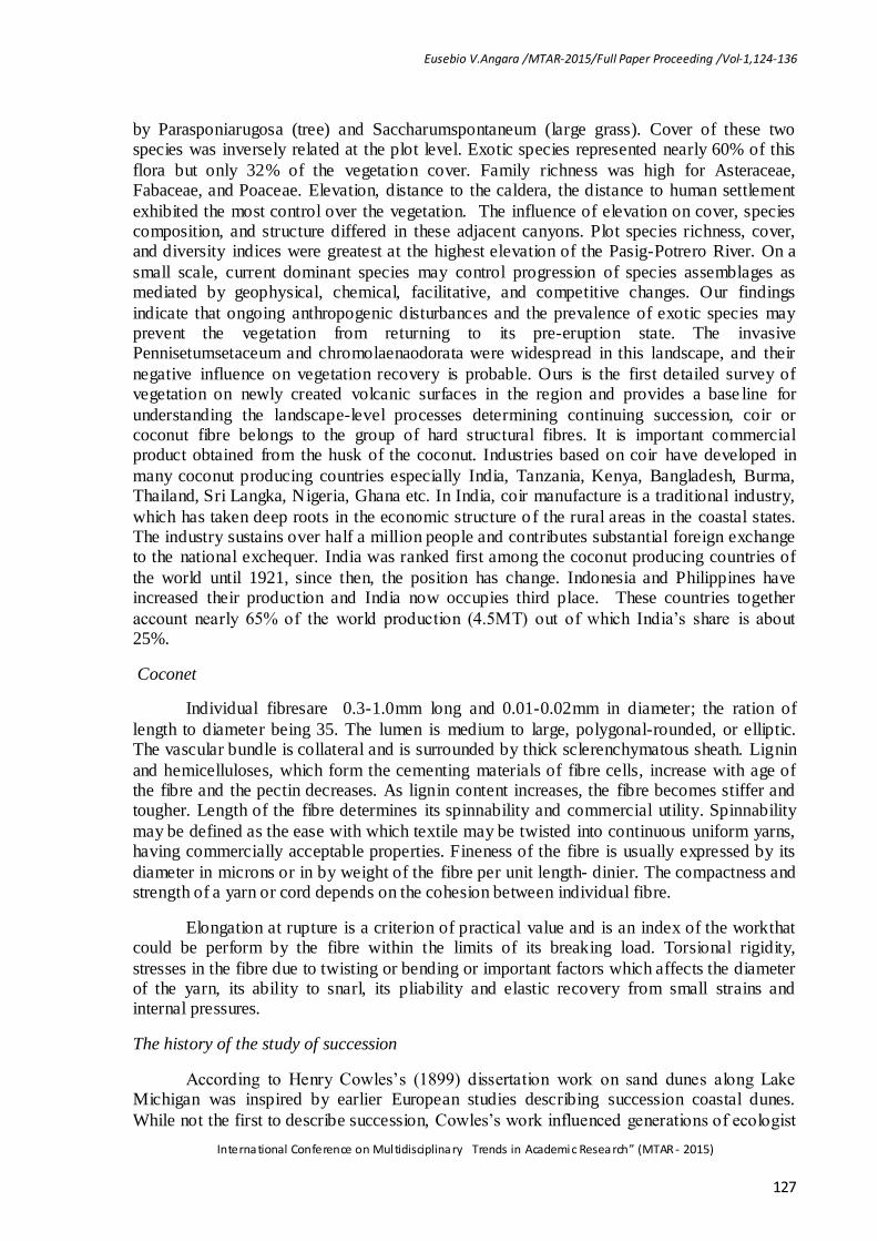
understanding the landscape-level processes determining continuing succession, coir or coconut fibre belongs to the group of hard structural fibres. It is important commercial product obtained from the husk of the coconut. Industries based on coir have developed in
many coconut producing countries especially India, Tanzania, Kenya, Bangladesh, Burma, Thailand, Sri Langka, Nigeria, Ghana etc. In India, coir manufacture is a traditional industry,
which has taken deep roots in the economic structure o f the rural areas in the coastal states. The industry sustains over half a million people and contributes substantial foreign exchange to the national exchequer. India was ranked first among the coconut producing countries of
the world until 1921, since then, the position has change. Indonesia and Philippines have increased their production and India now occupies third place. These countries together
account nearly 65% of the world production (4.5MT) out of which India’s share is about 25%.
Coconet
Individual fibresare 0.3-1.0mm long and 0.01-0.02mm in diameter; the ration of
length to diameter being 35. The lumen is medium to large, polygonal-rounded, or elliptic. The vascular bundle is collateral and is surrounded by thick sclerenchymatous sheath. Lignin
and hemicelluloses, which form the cementing materials of fibre cells, increase with age of the fibre and the pectin decreases. As lignin content increases, the fibre becomes stiffer and tougher. Length of the fibre determines its spinnability and commercial utility. Spinnability
may be defined as the ease with which textile may be twisted into continuous uniform yarns, having commercially acceptable properties. Fineness of the fibre is usually expressed by its
diameter in microns or in by weight of the fibre per unit length- dinier. The compactness and strength of a yarn or cord depends on the cohesion between individual fibre.
Elongation at rupture is a criterion of practical value and is an index of the workthat could be perform by the fibre within the limits of its breaking load. Torsional rigidity,
stresses in the fibre due to twisting or bending or important factors which affects the diameter of the yarn, its ability to snarl, its pliability and elastic recovery from small strains and internal pressures.
The history of the study of succession
According to Henry Cowles’s (1899) dissertation work on sand dunes along Lake Michigan was inspired by earlier European studies describing succession coastal dunes.
While not the first to describe succession, Cowles’s work influenced generations of ecologist

Eusebio V.Angara /MTAR-2015/Full Paper Proceeding /Vol-1,124-136
International Conference on Multidisciplinary Trends in Academic Research” (MTAR - 2015)
128
by defining lawsunderlying the patterns of community change. Henry Cowles recognize plant communities as being dynamic, both on species composition and the underlying
physical environment, a view that still holds to this day. The basic idea that plant communities of different ages in sand dunes reflected how the communities changed over
time. Cowls and others have used the chronosequence approach to better understand the successional process. Since, it would be difficult to follow a successional sequence that lasted decades or centuries, this method replaces atime period by spatial differences
(locations of different ages) to infer how succession proceeds (see Johnson and Miyanishi 2008 for a criticism of this approach). The stage in a successional sequence is termed a sere.
How this process worked has been a dominant question in the field of ecology, especially plant ecology. Plants are the dominant feature of the landscape, therefore, received of the most attentionover the past century.Ecologist have also identified parallel successional
patterns in animals and have even documentedanimals affecting the directions and rate of succession. The study of succession is now ubiquitous, being investigated in practically all
ecosystems.
Coconut Husk can stop Soil Erosion, says PCA
According to Gallarde (2012), the bio-engineering technology using what was considered before as farm waste being suggested to prevent soil erosion in sloping areas in
river banks in Negros Oriental by Philippine Coconut Authority provincial manager Brendan Trasmonte, the coconut husk, or “bunot” in the dialect, and a by-product of copra, can be
processed into coco-nets similar to that of geotextile, Trasmonte said. He added the decorticated coco fiber can be twined and weaved into nets that can be installed in slopes or in river banks as mitigating measures.If the technology is acceptable andadopted by local
government unit.Trasmonte said the PCA can assist in the training and installation of the concept.
After the coco nets are in place vegetation is allowed, like the planting of vitiber, a kind of grass whose roots can penetrate up to three meters underneath the soil. The water-
holding capacity of this technology capacity of this technology can increase with the planning of trees and bamboos along banks, he added. “The process will not only generated
jobs for coconut farmers, weavers and decorticators, but will also save the government more than half the cost of constructing dikes,”.Trasmonte said. Raw material is also not a problem because there are about nine million coconut trees in the province.
Field Testing of Bio- Textile and Bio- Logs to Mitigate Soil Slope Erosion in Maria Aurora
National Highway
Angara E. V., et, al (2010) concluded that in terms of top soil loss, Treatments
covered with geo-nets. With 4m interval of bio-logs and planted with Perennial Peanuts were the most effective in terms of minimizing top soil loss in disturbed sloping areas with more than 600 slopes. Control (T1) tend to have the highest rate of top soil loss because it has no
net that will serve as barriers to slow down the velocity of run- off water.
Based on the results, the highest amount of erosion in the experimental areas was 0.88t/ha. This is far below the tolerable erosion limit in a disturbed area which is 2.0t/ha. They also found that if the soil is compact, it tends to decrease the size of pore spaces and
when is the landscape is completely devegetated, the infiltration rate decreases while the run-off increases thereby increasing the erosion rate.

Eusebio V.Angara /MTAR-2015/Full Paper Proceeding /Vol-1,124-136
International Conference on Multidisciplinary Trends in Academic Research” (MTAR - 2015)
129
Methodology
Location
This research study was conducted along the Canile-Pantabangan Road. It was
selected because of the presence of coco-net and bio-logs with the different mesh sizes and vegetation on the disturbed areas due to road network construction. Three sites were selected: Site 1 and 2 are located at SitioCalao, BrgyWenceslao, Maria Aurora while Site 3 is at Sitio,
Masantol, Canili Area, Maria Aurora, Philippines.
Three plots measuring 2x2m were established on top, middle, and lower portion of the 3 study sites. Different species of plots present in each plots were identified, counted, and tabulated and were subjected to frequency counts.
Identification of species were done by experts and aided with Lexicon to further verify the correctness of the process.
Data gathering instruments
In the conduct of the study, the following were used: 1) Plastic straw – used to establish experimental plots; 2) Meter tape – to measure the area of experimental plots; 3)
Paint and tag – used to identify the tree and other plant species; 4) Pencil and data book – recording of gathered data; and 5) Maps – to locate the previous research area.
Data gathering procedures
Generally, this research study determined the 3 year vegetational succession along the disturbed areas due to road construction, 3 plots on each site were established measuring 2m x 2m (top, middle, and lower portion). All species of trees and other plants were counted and
identified. Recording was carefully executed to eliminate human errors. Later tabulated and subjected to simple frequency counts.
Data gathered. The data gathered in this study were the following:
I. Trees and saplings
1. Identification as to their:
a. Common name
b. Family name
c. Scientific name
2. Species count
II. Undergrowth:
1. Identification as (seedlings, grass, ferns, vines, etc)
a. Common name
b. Family name

Eusebio V.Angara /MTAR-2015/Full Paper Proceeding /Vol-1,124-136
International Conference on Multidisciplinary Trends in Academic Research” (MTAR - 2015)
130
c. Scientific name
2. Species count (%cover)
3. Species diversity (species composition)
3.5 Data analysis and interpretation. The data gathered were tabulated , analyzed and
interpreted using descriptive statistics of sum, average, and percentages. For diversity parameters, the ff formula was used.
Frequency of species
Percentage = ---------------------------------------- x 100
Total frequency of the species
IS = (2C/A+B)
Where: IS = index of similarity
C = Number of species common to two plots
A = Total number of species in plot A
B = Total number of species in plot B
Principal Component Analysis (CPA). A two dimensional principal components analysis was applied to determine the similarity of the different plots. This includes the following steps:
1. Obtain importance values of the species (vegetative structure analysis)
2. Obtain index of similarity (IS) using Sorensens formula
3. Enter values of IS in a nxn symmetric index of similarity matrix
4. Input the matrix to the data view of SPSS software and run data reduction (using CPA as factor)
Two dimensional scatter plots of CPA scores showed inter plot spatial relationships. Two dimensional plots were plotted using Excel graphic and analyzed based on the principle
that the distance between the points or plots in the scatter represents the degree of inter plot similarity based on the principal vegetative component.
Results And Discussion
Composition and Diversity
Within the area of previous research study, 3 plots where carefully established with 4
treatments,in aerosion prone area along Canili-Pantabangan Road Network. Table 1 show that T1 have 14 species, T2 have 16 species, T3 have 13 species, and T4 have 14 species,
which belong to 11 families. In terms of number of species per family, Fabaceae was found numerous with the species and the rest with an average of 1-2 species per family. The number of species per plot ranges from 7-15 with an average of 10.

Eusebio V.Angara /MTAR-2015/Full Paper Proceeding /Vol-1,124-136
International Conference on Multidisciplinary Trends in Academic Research” (MTAR - 2015)
131
In terms of the number of individuals per species, Vetiver grass (Viteverizizniodes’ Monto) has the highest number of individuals=386, followed by Pakupak(Pteridophyta)=249,
and Ipil- ipil(Leucaena leucocephala)=104. Of all numerous species, 2 of them belong to family Fabaceae, and the rest are from Mimosaceae, Graminaceae and Aspidiaceae. It further
showed that Graminacea family which have the highest number of individuals, and abundance in all mesh sizes, these can be attributed to the fact that they been planted after the installation of coco-nets and bio- logs.
Table 1.
Species composition in the study area (T1).
Common name Scientific name Family name No of individual/spp
Trees
Kakauate Gliricida sepium Fabaceae 31
Ipil-Ipil Leucaena leucocephala Mimosaceae 25
Hawili Ficcus septic Moraceae 3
Is-Is Leucosyke capitellana Urticaceae 1
Tibig Ficus nota Moraceae 7
Takip-asin Makaranga grandifolia Euphorbiaceae 2
Coconut Cocos nucifera Arecaceae 2
Undergrowths
Perennial peanuts Arachis glabrata Fabaceae 41
Makahiya Mimosa pudica Fabaceae 25
Carabao grass Paspalumconjugatum Poaceae 9
Vetiver grass Viteverizizniodes’ Monto Gramenacea 89
Pakupak Pteridophyta Aspidiaceae 58
Hagonoi Chomolaem odorata Asteraceae 19
Bikas Mikania cordata Asteraceae 20
Table 1. Continued. . . (T2)
Common name Scientific name Family name No of individual/spp
Trees
Hawili Ficcus septic Moraceae 4
Kakauate Gliricida sepium Fabaceae 30
Eusebio V.Angara /MTAR-2015/Full Paper Proceeding /Vol-1,124-136
International Conference on Multidisciplinary Trends in Academic Research” (MTAR - 2015)
132
Ipil-Ipil Leucaena leucocephala Mimosaceae 22
Tibig Ficus nota Moraceae 3
Is-Is Leucosyke capitellana Urticaceae 4
Binunga Macaranga tanarius Euphorbiaceae 2
Alateris Mutinga calabura Mitingiaceae 3
Takip-asin Makarangagrandifolia Euphorbiaceae 3
Coconut Cocos nucifera Arecaceae 3
Undergrowths
Perennial peanuts Arachis glabrata Fabaceae 36
Makahiya Mimosa pudica Fabaceae 13
Carabao grass Paspalumconjugatum Poaceae 20
Vetiver grass Viteverizizniodes’ Monto Gramenacea 84
Pakupak Pteridophyta Aspidiaceae 75
Hagonoi Chomolaem odorata Asteraceae 33
Bikas Mikania cordata Asteraceae 35
Table 1. Continued. . . (T3)
Common name Scientific name Family name No of individual/spp
Trees
Kakauate Gliricida sepium Fabaceae 34
Ipil-Ipil Leucaena leucocephala Mimosaceae 29
Is-Is Leucosyke capitellana Urticaceae 5
Tibig Ficus nota Moraceae 6
Takip-asin Makaranga grandifolia Euphorbiaceae 4
Hawili Ficcus septic Moraceae 2
Undergrowths
Perennial peanuts Arachis glabrata Fabaceae 38
Makahiya Mimosa pudica Fabaceae 12
Carabao grass Paspalum conjugatum Poaceae 25
Eusebio V.Angara /MTAR-2015/Full Paper Proceeding /Vol-1,124-136
International Conference on Multidisciplinary Trends in Academic Research” (MTAR - 2015)
133
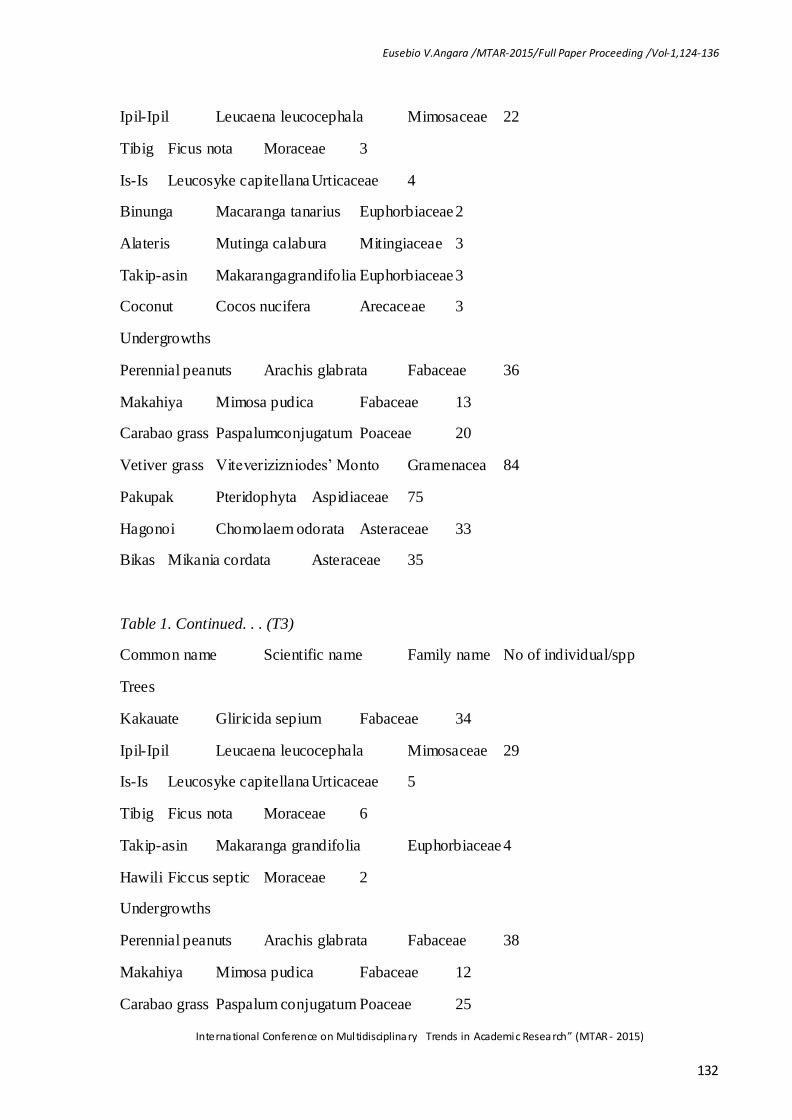
Vetiver grass Viteverizizniodes’ Monto Gramenacea 98
Pakupak Pteridophyta Aspidiaceae 55
Hagonoi Chomolaem odorata Asteraceae 37
Bikas Mikania cordata Asteraceae 25
Table 1. Continued. . . (T4)
Common name Scientific name Family name No of individual/spp
Trees
Tibig Ficus nota Moraceae 6
Is-Is Leucosyke capitellana Urticaceae 7
Kakauate Gliricida sepium Fabaceae 23
Ipil-Ipil Leucaena leucocephala Mimosaceae 27
Binunga Macaranga tanarius Euphorbiaceae 2
Hawili Ficcus septic Moraceae 3
Coconut Cocos nucifera Arecaceae 3
Undergrowths
Perennial peanuts Arachis glabrata Fabaceae 31
Makahiya Mimosa pudica Fabaceae 13
Carabao grass Paspalum conjugatum Poaceae 20
Vetiver grass Viteverizizniodes’ Monto Gramenacea 94
Pakupak Pteridophyta Aspidiaceae 56
Hagonoi Chomolaem odorata Asteraceae 16
Bikas Mikania cordata Asteraceae 28
Fig 1: Similarity distribution of plot in relation to vegetation.
Principal components analysis determines the similarity of vegetation composition of the sample plots. This similarity is graphed with sample plot as points. The distance of the
points reflects the degree of similarity. His points that are close together are similar in vegetation composition and those that are far apart are dissimilar. Their differences are based on a community coefficient derived from important values. A two dimens ional scatter graph
was constructed to graphically illustrate the inter relationship of 12 plots. Appendix 1 shows the index similarity among all possible pairs of 12 plots. The result of a 2-dimensional graph
shows that there is no factor in mesh size to vegetation but to the area, because the mesh size where closely similar to each other results shows that the index mixing of plots describes no distinct grouping of species function of treatment. It reveals that the area is almost

Eusebio V.Angara /MTAR-2015/Full Paper Proceeding /Vol-1,124-136
International Conference on Multidisciplinary Trends in Academic Research” (MTAR - 2015)
134
heterogeneous in character that each species are widely scattered at all points in the study area.
Result showed that there were 11 plants in site 1 namely Carabao grass(Paspalum
conjugatum), Hagonoi(Chomolaem odorata), Hawili(Ficcus septic), Ipil- ipil(Leucaena leucocephala), Is- is(Leucosyke capitellana), Kakauate(Gliricida sepium), Makahiya(Mimosa pudica), Pakupak(Pteridophyta), Perennial peanuts(Arachis glabrata), Tibig(Ficus nota), and
Vetiver grass (Viteverizizniodes’ Monto), while 15 plants were found in Site 2 namely Alateris(Mutinga calabura), Binunga(Macaranga tanarius), Carabao grass(Paspalum
conjugatum), Hagonoi(Chomolaem odorata), Hawili(Ficcus septic), Ipil- ipil(Leucaena leucocephala), Is- is(Leucosyke capitellana), Kakauate(Gliricida sepium), Makahiya(Mimosa pudica), Pakupak(Pteridophyta), Perennial peanut(Arachis glabrata) Takip-asin(Makaranga
grandifolia), Tibig(Ficus nota), and Vetiver grass(Viteverizizniodes’ Monto). On the other hand Site 3 had 8 plants namely Carabao grass(Paspalum conjugatum), Hagonoi(Chomolaem
odorata), Ipil- ipil(Leucaena leucocephala). Kakauate(Gliricida sepium), Pakupak(Pteridophyta), Perennial peanut(Arachis glabrata), Tibig(Ficus nota), and Vetiver grass(Viteverizizniodes’ Monto).
Generally, the 3 study sites contained the following: Alateris(Mutinga calabura) =3(0.2%), Binunga(Macaranga tanarius)=4(0.3%), Carabao grass(Paspalum conjugatum) =74(5.1%),
Coconut(Cocos nucifera)=8(0.6%), Bikas(Mikania cordata)=91(6.3%), Hagonoy(Chomolaem odorata)=16(8.0%), Makahiya(Mimosa pudica)=63(4.4%),
Pakupak(Pteridophyta)=249(17.3%), Perennial peanuts(Arachis glabrata)=146(10.1%), Takip-asin(Makaranga grandifolia)=9(0.6%), Tibig(Ficus nota)=22(1.5%), and Perennial peanut(Arachis glabrata)=386(26.7%).
It was also found out that the 8 species present in all study sites namely Carabao
grass(Paspalum conjugatum), Hagonoi(Chomolaem odorata), Ipil- ipil(Leucaena leucocephala), Kakauate(Gliricida sepium), Pakupak(Pteridophyta), Perennial peanut(Arachis glabrata), Tibig(Ficus nota), and Vetiver grass(Viteverizizniodes’ Monto).
Table 2. Vegetation found in the study site.
Common name Site 1 Site 2 Site 3 Frequency Percentage
Alateris - 3 - 3 0.2
Binunga - 4 - 4 0.3
Carabao grass 29 15 30 74 5.1
Coconut - 8 - 8 0.6
Bikas - - 91 91 6.3
Hagonoi 58 51 7 116 8.0
Hawili 6 8 - 14 1.0
Ipil-Ipil 44 37 23 104 7.2
Is-Is 9 10 - 19 1.3

Eusebio V.Angara /MTAR-2015/Full Paper Proceeding /Vol-1,124-136
International Conference on Multidisciplinary Trends in Academic Research” (MTAR - 2015)
135
Kakauate 59 51 25 135 9.4
Makahiya 39 24 - 63 4.4
Pakupak 86 97 66 249 17.3
Perennial peanut 48 54 44 146 10.1
Takipasin - 9 - 9 0.6
Tibig 11 7 4 22 1.5
Vetiver grass 91 114 181 386 26.7
Total 1443 100.0
It showed that the 3 sites were covered mostly by Vetiver grass (Viteverizizniodes’ Monto), Pakupak (Pteridophyta), Perennial peanut (Arachis glabrata), Hagonoi
(Chomoleomodorata), Ipil- ipil (Leucana leucocephala), Bikas (Mikania cordata), Carabao grass (Paspalum conjugatum), Makahiya (Mimosa pudica), Kakauate (Gliricida sepium), and Hawili (Ficcus septic). It was also found out that the most diverse species in the study sites
was Vetiver grass (Viteverizizniodes’ Monto) which belongs to Family Graminaceae. It further showed that undergrowth have the highest number of species (7), which have the
greater value to reduce the erosion in the study sites. Soil erosion has been a major issue in the past and will be even greater issue in the future.
Top 5 species found on the study areas were: Vetiver grass (Viteverizizaniodes’ Monto), Pakupak (Pteridophyta), Ipil- ipil (Leucana leucocephala), Perenial peanuts (Arachis
glabrata), and Hagonoi (Chomoleomodorata).
Summary And Conclusions
The study was conducted to determine the vegetation successions found in the disturbed areas of Canili-Pantabangan Road Network in Aurora Province, Philippines to
determine the vegetation composition and also the vegetation diversity of the study sites. Simple inventory assessment was used to attain the above mentioned objectives. Field work
consists of inventory, identification, measurement, and tree markings.
Twelve quadrants plots in the study area were established for data collection.
Composition and diversity showed that there were different numbers of species in every treatments, which all belongs to 11 families. Fabaceae was found to be numerous within 3
species and the rest with an average of 1 to 2 species per family. The number of species per plot ranges from 7-15 with an average of 10.
In terms of the number of individual, the area is dominated with Vetiver grass (Viteverizizaniodes’ Monto), followed by Pakupak (Pteridophyta), then by Perrenial peanuts
(Arachis glabrata), then by Kakauate (Gliricida sepium), and the least was Ipil- ipil (Leucana leucocephala). It further revealed that Graminacea, Aspidiaceae, Fabaceae, and Mimosaneae are the top 4 families which have the greater importance value. Graminacea species are more
diverse in the area and it could be an important tool to reduce erosion and other environmental factor. In fact according to Kidd (2010), Vetiver grasses could be reduce
erosion by up to 90%, reduce and conserve rainfall runoff by as much as 70%, improve

Eusebio V.Angara /MTAR-2015/Full Paper Proceeding /Vol-1,124-136
International Conference on Multidisciplinary Trends in Academic Research” (MTAR - 2015)
136
ground water recharge, remove pollutants from water, reduce the risk of flooding, and improve economic benefits to communities.
Recommendations
The following were highly recommended:
1. The Philippine government should adopt the use of coco-net and bio- logs to control erosion on disturbed areas due to construction of road network and similar conditions.
2. Protection, conservation, and management of similar areas must be undertaken to ensure vegetation growth for the next generation; and
3. Information dissemination must be undertaken to promote the use of coco-net and bio- logs.
References
Agbayani, E. A. 2003. Vegetational analysis of ASCOT reservation area.Unpublished undergraduate thesis.Aurora State College of Technology, Baler, Aurora. Philippines.
Anderson, J. R., & Thampapillai, J. (1990). Soil conservation in developing countries. World Bank Publications Angara, E. V., Escueta, S. C., Rotaquio, E., Barrogo, L. H., Gallego, R. J., Resueno, M. A.,
... & Sagabain, K. J. (2010). Field Testing of Bio-Engineering Techniques using Geo-Textile and Bio-Logs to Mitigate Soil Slope Erosion in Maria Aurora National Highway. ASCOT
Research International Journal, 3. Cowles, H. 1999. The history of study of succession retrieved from http://www.nature.com/scitable/knowledge/successional-change-in-communities.
1326149. Gallarde, J. 2012. Coconut husk can stop soil erosion, says PCA Philippine Star article.
March 9, 2012. Kidd, R. 2009.Agroforestry database: a tree reference and selection guide version 4.0 (http:www.worldagroforestry.org/af/treedb/).
Marler, T.E. 2011.Primary succession along an eleven gradient 15years after the eruption of Mount Pinatubo, Luzon. Philippines. Published by: University of Hawaii.
Pcarrd. 1992. Accounting for the depreciation of soil in the upland. Retrieved from (www.fao.org/docrep/006/ab604e/AB604E03.htm)
Acknowledgment
The authors wish to extend their heartfelt thanks and gratitude to the ASCOT’s Director of Research for providing the funding requirements and by extending their personal help and expertise in the conduct of the study. Likewise, the author’s wishes to convey their
gratitude to all the personnel of Aurora State College of Technology for their help and support that leads to the success of the research study.