Mt Margaret Nickel-Cobalt Project - EPA...
70
Mt Margaret Nickel-Cobalt Project Anaconda Nickel Limited Report and recommendations of the Environmental Protection Authority Environmental Protection Authority Perth, Western Australia Bulletin 1025 August 2001
-
Upload
truongthuy -
Category
Documents
-
view
213 -
download
0
Transcript of Mt Margaret Nickel-Cobalt Project - EPA...
Mt Margaret Nickel-Cobalt Project
Anaconda Nickel Limited
Report and recommendations of the Environmental Protection Authority
Environmental Protection Authority Perth, Western Australia
Bulletin 1025 August 2001

ISBN. 0 7307 6613 6 ISSN. 1030 - 0120 Assessment No. 1317

i
Summary and recommendations Anaconda Nickel Ltd (�the proponent�) proposes to develop the Mt Margaret Nickel-Cobalt Project (�the proposal�) located approximately 300 kilometres north of Kalgoorlie. This report provides the Environmental Protection Authority�s (EPA) advice and recommendations to the Minister for the Environment and Heritage on the environmental factors relevant to the proposal. Section 44 of the Environmental Protection Act 1986 requires the EPA to report to the Minister for the Environment and Heritage on the environmental factors relevant to the proposal and on the conditions and procedures to which the proposal should be subject, if implemented. In addition, the EPA may make recommendations as it sees fit.
Relevant environmental factors The EPA decided that the following environmental factors relevant to the proposal require detailed evaluation in the report: (a) Declared Rare and Priority flora, and other flora of conservation significance; (b) regional conservation; (c) borefield operation; (d) subterranean fauna; and (e) Aboriginal heritage and culture.
There are a number of other factors which are very relevant to the proposal, but the EPA is of the view that the information set out in Appendix 3 provides sufficient evaluation.
Conclusion The EPA has considered the proposal by Anaconda Nickel Ltd to develop the Mt Margaret Nickel-Cobalt Project. Based on the relevant factors listed above, the EPA concludes that the key issues associated with the proposal are clearing of up to 11,100 ha of native vegetation over ~ 30 years and the management of significant flora, the abstraction and use of 50 million litres of groundwater per day, management of surrounding areas for regional conservation, and the protection of subterranean fauna, and Aboriginal heritage and culture. In considering these issues, the EPA noted that:
�� the proponent will rehabilitate areas disturbed under the proposal under an integrated mining and rehabilitation plan, which will evaluate opportunities over the life of the project (through five-yearly reviews) to reduce the long-term changes to the land through backfilling pits and in-pit disposal of tailings;
�� the State agencies responsible for regional conservation, significant flora species, water resources, subterranean fauna, and Aboriginal heritage and culture have been extensively consulted on the proposal, and are satisfied with the information provided to date; and
�� the proponent has consulted with other stakeholders in the project, including Aboriginal communities and pastoral lease owners in the area of the project, and has established appropriate and meaningful routes for ongoing consultation.

ii
The EPA commends the proponent for its commitment to provide for long-term regional conservation, and is very optimistic that the proponent, in collaboration with CALM, will develop a strategy that can provide lasting conservation benefits for the region.
With regard to the water requirements for the proposal, the EPA considers that the proponent has assessed, as far as possible prior to actual groundwater abstraction, the proposals affect on groundwater systems. The EPA has concluded that the proposal is capable of being managed to meet the EPA�s objectives provided there is satisfactory implementation by the proponent of the proponent�s commitments and the recommended conditions set out in Appendix 4 and summarised in Section 4.
Recommendations The EPA submits the following recommendations to the Minister for the Environment and Heritage. 1. That the Minister notes that the proposal being assessed is for development of the Mt
Margaret Nickel-Cobalt Project, located approximately 300 kilometres north of Kalgoorlie.
2. That the Minister considers the report on the relevant environmental factors as set out in Section 3.
3. That the Minister notes that the EPA has concluded that it is unlikely that the EPA�s objectives would be compromised, provided there is satisfactory implementation by the proponent of the recommended conditions set out in Appendix 4, and summarised in Section 4, including the proponent�s commitments.
4. That the Minister imposes the conditions and procedures recommended in Appendix 4 of this report.
Conditions Having considered the proponent�s commitments and information provided in this report, the EPA has developed a set of conditions that the EPA recommends be imposed if the proposal by Anaconda Nickel Ltd to develop the Mt Margaret Nickel-Cobalt Project is approved for implementation. These conditions are presented in Appendix 4. Matters addressed in the conditions include the following: (a) that the proponent shall fulfil the commitments in the Consolidated Commitments
statement set out as an attachment to the recommended conditions in Appendix 4; (b) that the proponent be required to prepare and implement a Subterranean Fauna
Sampling Plan, Borefield Contingency Plan and Significant Flora Management Plan for the proposal; and
(c) that standard conditions appropriate to mining and processing operations of this scale and type be applied.

Contents Page
Summary and recommendations ............................................................................................. i 1. Introduction ...................................................................................................................... 1 2. The proposal ..................................................................................................................... 1 3. Relevant environmental factors ...................................................................................... 6
3.1 Declared Rare and Priority flora, and other flora of conservation significance ...... 6 3.2 Regional conservation ............................................................................................. 9 3.3 Borefield operation................................................................................................ 10 3.4 Subterranean fauna ................................................................................................ 16 3.5 Aboriginal heritage and culture ............................................................................. 20
4. Conditions and commitments........................................................................................ 23 4.1 Proponent�s commitments..................................................................................... 23 4.2 Recommended conditions ..................................................................................... 24
5. Conclusions ..................................................................................................................... 24 6. Recommendations .......................................................................................................... 25 Table 1. Summary of key proposal characteristics 5
Figures 1. Location of the Mt Margaret Nickel-Cobalt Project 2 2. Project Layout 3 3. Location of significant flora populations 8 4. Predicted worst-case drawdown at Depot Springs 14 5. Predicted worst-case drawdown at Sandstone South and stygofauna sampling sites 15 6. Sturt Meadows calcrete mining area and stygofauna sampling sites 19
Appendices 1. List of submitters 2. References 3. Summary of identification of relevant environmental factors 4. Recommended Environmental Conditions and Proponent�s Consolidated Commitments 5. Summary of Submissions and Proponent's Response to Submissions
1
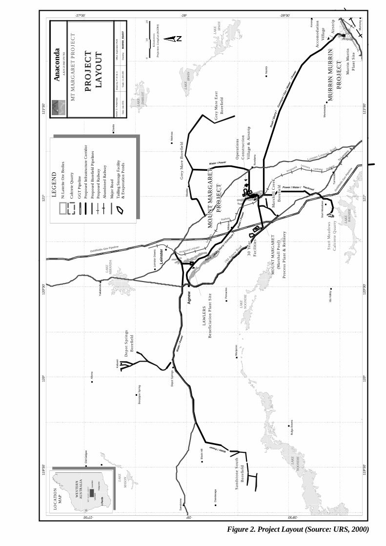
1. Introduction Anaconda Nickel Ltd (�the proponent�) is seeking environmental approval to develop the Mt Margaret Nickel-Cobalt Project (�the proposal�), which is located approximately 300 kilometres north of Kalgoorlie (Figure 1). This report provides the advice and recommendations of the Environmental Protection Authority (EPA) to the Minister for the Environment and Heritage on the environmental factors relevant to this proposal. The proposal has been formally assessed under S38 the Environmental Protection Act 1986 at the Public Environmental Review level of assessment, and is being jointly assessed by Environment Australia at Public Environmental Report level under the Environment Protection (Impact of Proposals) Act 1974. Further details of the proposal are presented in Section 2 of this report. Section 3 discusses environmental factors relevant to the proposal. The conditions and commitments to which the proposal should be subject, if the Minister determines that it may be implemented, are set out in Section 4. Section 5 presents the EPA�s conclusions and Section 6, the EPA�s recommendations. The Public Environmental Review/Public Environmental Report (PER) document (URS, 2000) was available for public comment from 11 December 2000 to 19 February 2001. The organisations and individuals that submitted comment on the PER are listed in Appendix 1. Appendix 2 contains the references cited in the EPA�s Bulletin. Appendix 3 sets out the table of environmental factors considered and those identified as being relevant environmental factors for the EPA�s evaluation. Appendix 4 provides the complete list of proposed Environmental Conditions and the proponent�s commitments. Appendix 5 contains a summary of submissions and the proponent�s response to submissions. This is included as a matter of information only and does not form part of the EPA�s report and recommendations. Issues arising from this process, and which the EPA has taken into account, appear in the report itself.
2. The proposal The proposal is for a large-scale nickel and cobalt mining and processing operation in the north-eastern goldfields of WA. The proposal will involve the mining and processing of up to 15 million dry tonnes per annum (Mtpa) of lateritic ore to produce approximately 60,000 tonnes per annum (tpa) of nickel and up to 8,000 tpa of cobalt. The ore will be mined at Marshall Pool, 55 km south-southeast of Leinster, and Lawlers, 10 km south of Leinster (see Figures 1 and 2). Primary crushing, beneficiation and blending will be undertaken at each of these mining areas before the ore is transported to the Marshall Pool area for processing. The processing plant will use a pressure acid leach process to dissolve the nickel and cobalt from the ore. The dissolved nickel and cobalt are then recovered through a series of processing steps including precipitation and solvent extraction before being refined on-site to produce nickel and cobalt metal.

KALGOORLIE
31059-018-071
KMF 22 Nov 00
Job No.
Prep. By
Chk’d By
Office Perth, Western AustraliaPhone: +61 8 9221 1630
LAVERTON
LEINSTER
LEONORA
LakeCarey
Mt. MargaretMission
BOULDER
MT MARGARET:LAWLERS MINING AREA
MT MARGARET:MARSHALL POOL
MINING AREA
MURRIN MURRINNORTH
MURRIN MURRINSOUTH
MURRIN MURRINEAST
Mt. MorgansMine
Malcolm
Kookynie
Kalgoorlie - Meekatharra
Leonora
- Lave
rton
Leinster - Leonora
To Wiluna
MENZIES
Broad Arrow
Kalgoorlie -
Meekatharra
Port Hedland
PERTH
LOCALITY MAP
Esperance
Kalgoorlie
MT MARGARETPROJECT
0 50km25
SCALE
Anaconda Nickel LimitedMT MARGARET PROJECT
PUBLIC ENVIRONMENTAL REVIEW
LOCATION OF MT MARGARET PROJECT
Figure 1. Location Plan (Source: URS, 2000)
IRW
IN
IRW
INLA
KE
LAK
E
DAR
LOT
LAK
E
RAES
IDE
LAK
E
LAK
EM
IRAN
DA
NO
ON
DIE
LAK
E
NO
ON
DIE
LAK
E
LAK
E
MAS
ON
MU
RR
IN M
UR
RIN
MU
RR
IN M
UR
RIN
MU
RR
IN M
UR
RIN
MU
RR
IN M
UR
RIN
MU
RR
IN M
UR
RIN
MU
RR
IN M
UR
RIN
MU
RR
IN M
UR
RIN
MU
RR
IN M
UR
RIN
MU
RR
IN M
UR
RIN
MU
RR
IN M
UR
RIN
MU
RR
IN M
UR
RIN
MU
RR
IN M
UR
RIN
MU
RR
IN M
UR
RIN
MU
RR
IN M
UR
RIN
MU
RR
IN M
UR
RIN
MU
RR
IN M
UR
RIN
MU
RR
IN M
UR
RIN
MU
RR
IN M
UR
RIN
MU
RR
IN M
UR
RIN
MU
RR
IN M
UR
RIN
MU
RR
IN M
UR
RIN
MU
RR
IN M
UR
RIN
MU
RR
IN M
UR
RIN
MU
RR
IN M
UR
RIN
MU
RR
IN M
UR
RIN
MU
RR
IN M
UR
RIN
MU
RR
IN M
UR
RIN
MU
RR
IN M
UR
RIN
MU
RR
IN M
UR
RIN
MU
RR
IN M
UR
RIN
MU
RR
IN M
UR
RIN
MU
RR
IN M
UR
RIN
MU
RR
IN M
UR
RIN
MU
RR
IN M
UR
RIN
MU
RR
IN M
UR
RIN
MU
RR
IN M
UR
RIN
MU
RR
IN M
UR
RIN
MU
RR
IN M
UR
RIN
MU
RR
IN M
UR
RIN
MU
RR
IN M
UR
RIN
MU
RR
IN M
UR
RIN
MU
RR
IN M
UR
RIN
MU
RR
IN M
UR
RIN
MU
RR
IN M
UR
RIN
MU
RR
IN M
UR
RIN
MU
RR
IN M
UR
RIN
MU
RR
IN M
UR
RIN
MU
RR
IN M
UR
RIN
MU
RR
IN M
UR
RIN
MU
RR
IN M
UR
RIN
PR
OJE
CT
PR
OJE
CT
PR
OJE
CT
PR
OJE
CT
PR
OJE
CT
PR
OJE
CT
PR
OJE
CT
PR
OJE
CT
PR
OJE
CT
PR
OJE
CT
PR
OJE
CT
PR
OJE
CT
PR
OJE
CT
PR
OJE
CT
PR
OJE
CT
PR
OJE
CT
PR
OJE
CT
PR
OJE
CT
PR
OJE
CT
PR
OJE
CT
PR
OJE
CT
PR
OJE
CT
PR
OJE
CT
PR
OJE
CT
PR
OJE
CT
PR
OJE
CT
PR
OJE
CT
PR
OJE
CT
PR
OJE
CT
PR
OJE
CT
PR
OJE
CT
PR
OJE
CT
PR
OJE
CT
PR
OJE
CT
PR
OJE
CT
PR
OJE
CT
PR
OJE
CT
PR
OJE
CT
PR
OJE
CT
PR
OJE
CT
PR
OJE
CT
PR
OJE
CT
PR
OJE
CT
PR
OJE
CT
PR
OJE
CT
PR
OJE
CT
PR
OJE
CT
PR
OJE
CT
PR
OJE
CT
PR
OJE
CT
MO
UN
T M
AR
GA
RE
TM
OU
NT M
AR
GA
RE
TM
OU
NT M
AR
GA
RE
TM
OU
NT M
AR
GA
RE
TM
OU
NT M
AR
GA
RE
TM
OU
NT M
AR
GA
RE
TM
OU
NT M
AR
GA
RE
TM
OU
NT M
AR
GA
RE
TM
OU
NT M
AR
GA
RE
TM
OU
NT M
AR
GA
RE
TM
OU
NT M
AR
GA
RE
TM
OU
NT M
AR
GA
RE
TM
OU
NT M
AR
GA
RE
TM
OU
NT M
AR
GA
RE
TM
OU
NT M
AR
GA
RE
TM
OU
NT M
AR
GA
RE
TM
OU
NT M
AR
GA
RE
TM
OU
NT M
AR
GA
RE
TM
OU
NT M
AR
GA
RE
TM
OU
NT M
AR
GA
RE
TM
OU
NT M
AR
GA
RE
TM
OU
NT M
AR
GA
RE
TM
OU
NT M
AR
GA
RE
TM
OU
NT M
AR
GA
RE
TM
OU
NT M
AR
GA
RE
TM
OU
NT M
AR
GA
RE
TM
OU
NT M
AR
GA
RE
TM
OU
NT M
AR
GA
RE
TM
OU
NT M
AR
GA
RE
TM
OU
NT M
AR
GA
RE
TM
OU
NT M
AR
GA
RE
TM
OU
NT M
AR
GA
RE
TM
OU
NT M
AR
GA
RE
TM
OU
NT M
AR
GA
RE
TM
OU
NT M
AR
GA
RE
TM
OU
NT M
AR
GA
RE
TM
OU
NT M
AR
GA
RE
TM
OU
NT M
AR
GA
RE
TM
OU
NT M
AR
GA
RE
TM
OU
NT M
AR
GA
RE
TM
OU
NT M
AR
GA
RE
TM
OU
NT M
AR
GA
RE
TM
OU
NT M
AR
GA
RE
TM
OU
NT M
AR
GA
RE
TM
OU
NT M
AR
GA
RE
TM
OU
NT M
AR
GA
RE
TM
OU
NT M
AR
GA
RE
TM
OU
NT M
AR
GA
RE
TM
OU
NT M
AR
GA
RE
TM
OU
NT M
AR
GA
RE
T
PR
OJE
CT
PR
OJE
CT
PR
OJE
CT
PR
OJE
CT
PR
OJE
CT
PR
OJE
CT
PR
OJE
CT
PR
OJE
CT
PR
OJE
CT
PR
OJE
CT
PR
OJE
CT
PR
OJE
CT
PR
OJE
CT
PR
OJE
CT
PR
OJE
CT
PR
OJE
CT
PR
OJE
CT
PR
OJE
CT
PR
OJE
CT
PR
OJE
CT
PR
OJE
CT
PR
OJE
CT
PR
OJE
CT
PR
OJE
CT
PR
OJE
CT
PR
OJE
CT
PR
OJE
CT
PR
OJE
CT
PR
OJE
CT
PR
OJE
CT
PR
OJE
CT
PR
OJE
CT
PR
OJE
CT
PR
OJE
CT
PR
OJE
CT
PR
OJE
CT
PR
OJE
CT
PR
OJE
CT
PR
OJE
CT
PR
OJE
CT
PR
OJE
CT
PR
OJE
CT
PR
OJE
CT
PR
OJE
CT
PR
OJE
CT
PR
OJE
CT
PR
OJE
CT
PR
OJE
CT
PR
OJE
CT
PR
OJE
CT
p
p
p
pp
p
p
p
p
p
p
p
p
p
p
p
p
p
p
p
p
p
pp
p
p
p
p
p
p
p
p p
Mou
nt K
eith
Albi
on D
owns
Yeel
irrie
Lake
Mas
on
Old
Gid
gee
Blac
k H
ill
Sand
ston
e
Dan
dara
ga
Dep
ot S
prin
gs
Booy
lgoo
Spr
ing
Alto
na
Kalu
wiri
Lein
ster
Dow
ns
Yaka
bind
ieYa
ndal
Mel
rose
Bulg
a D
owns
Wee
bo
Wild
ara
Pinn
acle
s
Mun
jero
o
Stur
t Mea
dow
s
Ida
Valle
yTa
rmoo
la
Bund
arra
Mer
tond
ale
Banj
awar
n
Agn
ew
Lein
ster
Dar
da
Mur
nong
Koro
ng
Nam
bi
San
dsto
ne S
outh
San
dsto
ne S
outh
San
dsto
ne S
outh
San
dsto
ne S
outh
San
dsto
ne S
outh
San
dsto
ne S
outh
San
dsto
ne S
outh
San
dsto
ne S
outh
San
dsto
ne S
outh
San
dsto
ne S
outh
San
dsto
ne S
outh
San
dsto
ne S
outh
San
dsto
ne S
outh
San
dsto
ne S
outh
San
dsto
ne S
outh
San
dsto
ne S
outh
San
dsto
ne S
outh
San
dsto
ne S
outh
San
dsto
ne S
outh
San
dsto
ne S
outh
San
dsto
ne S
outh
San
dsto
ne S
outh
San
dsto
ne S
outh
San
dsto
ne S
outh
San
dsto
ne S
outh
San
dsto
ne S
outh
San
dsto
ne S
outh
San
dsto
ne S
outh
San
dsto
ne S
outh
San
dsto
ne S
outh
San
dsto
ne S
outh
San
dsto
ne S
outh
San
dsto
ne S
outh
San
dsto
ne S
outh
San
dsto
ne S
outh
San
dsto
ne S
outh
San
dsto
ne S
outh
San
dsto
ne S
outh
San
dsto
ne S
outh
San
dsto
ne S
outh
San
dsto
ne S
outh
San
dsto
ne S
outh
San
dsto
ne S
outh
San
dsto
ne S
outh
San
dsto
ne S
outh
San
dsto
ne S
outh
San
dsto
ne S
outh
San
dsto
ne S
outh
San
dsto
ne S
outh
Bor
efie
ldB
oref
ield
Bor
efie
ldB
oref
ield
Bor
efie
ldB
oref
ield
Bor
efie
ldB
oref
ield
Bor
efie
ldB
oref
ield
Bor
efie
ldB
oref
ield
Bor
efie
ldB
oref
ield
Bor
efie
ldB
oref
ield
Bor
efie
ldB
oref
ield
Bor
efie
ldB
oref
ield
Bor
efie
ldB
oref
ield
Bor
efie
ldB
oref
ield
Bor
efie
ldB
oref
ield
Bor
efie
ldB
oref
ield
Bor
efie
ldB
oref
ield
Bor
efie
ldB
oref
ield
Bor
efie
ldB
oref
ield
Bor
efie
ldB
oref
ield
Bor
efie
ldB
oref
ield
Bor
efie
ldB
oref
ield
Bor
efie
ldB
oref
ield
Bor
efie
ldB
oref
ield
Bor
efie
ldB
oref
ield
Bor
efie
ldB
oref
ield
Bor
efie
ld
Water / Power
LA
WLE
RS
LA
WLE
RS
LA
WLE
RS
LA
WLE
RS
LA
WLE
RS
LA
WLE
RS
LA
WLE
RS
LA
WLE
RS
LA
WLE
RS
LA
WLE
RS
LA
WLE
RS
LA
WLE
RS
LA
WLE
RS
LA
WLE
RS
LA
WLE
RS
LA
WLE
RS
LA
WLE
RS
LA
WLE
RS
LA
WLE
RS
LA
WLE
RS
LA
WLE
RS
LA
WLE
RS
LA
WLE
RS
LA
WLE
RS
LA
WLE
RS
LA
WLE
RS
LA
WLE
RS
LA
WLE
RS
LA
WLE
RS
LA
WLE
RS
LA
WLE
RS
LA
WLE
RS
LA
WLE
RS
LA
WLE
RS
LA
WLE
RS
LA
WLE
RS
LA
WLE
RS
LA
WLE
RS
LA
WLE
RS
LA
WLE
RS
LA
WLE
RS
LA
WLE
RS
LA
WLE
RS
LA
WLE
RS
LA
WLE
RS
LA
WLE
RS
LA
WLE
RS
LA
WLE
RS
LA
WLE
RS
Ben
efic
iati
on P
lant
Sit
eB
enef
icia
tion
Pla
nt S
ite
Ben
efic
iati
on P
lant
Sit
eB
enef
icia
tion
Pla
nt S
ite
Ben
efic
iati
on P
lant
Sit
eB
enef
icia
tion
Pla
nt S
ite
Ben
efic
iati
on P
lant
Sit
eB
enef
icia
tion
Pla
nt S
ite
Ben
efic
iati
on P
lant
Sit
eB
enef
icia
tion
Pla
nt S
ite
Ben
efic
iati
on P
lant
Sit
eB
enef
icia
tion
Pla
nt S
ite
Ben
efic
iati
on P
lant
Sit
eB
enef
icia
tion
Pla
nt S
ite
Ben
efic
iati
on P
lant
Sit
eB
enef
icia
tion
Pla
nt S
ite
Ben
efic
iati
on P
lant
Sit
eB
enef
icia
tion
Pla
nt S
ite
Ben
efic
iati
on P
lant
Sit
eB
enef
icia
tion
Pla
nt S
ite
Ben
efic
iati
on P
lant
Sit
eB
enef
icia
tion
Pla
nt S
ite
Ben
efic
iati
on P
lant
Sit
eB
enef
icia
tion
Pla
nt S
ite
Ben
efic
iati
on P
lant
Sit
eB
enef
icia
tion
Pla
nt S
ite
Ben
efic
iati
on P
lant
Sit
eB
enef
icia
tion
Pla
nt S
ite
Ben
efic
iati
on P
lant
Sit
eB
enef
icia
tion
Pla
nt S
ite
Ben
efic
iati
on P
lant
Sit
eB
enef
icia
tion
Pla
nt S
ite
Ben
efic
iati
on P
lant
Sit
eB
enef
icia
tion
Pla
nt S
ite
Ben
efic
iati
on P
lant
Sit
eB
enef
icia
tion
Pla
nt S
ite
Ben
efic
iati
on P
lant
Sit
eB
enef
icia
tion
Pla
nt S
ite
Ben
efic
iati
on P
lant
Sit
eB
enef
icia
tion
Pla
nt S
ite
Ben
efic
iati
on P
lant
Sit
eB
enef
icia
tion
Pla
nt S
ite
Ben
efic
iati
on P
lant
Sit
eB
enef
icia
tion
Pla
nt S
ite
Ben
efic
iati
on P
lant
Sit
eB
enef
icia
tion
Pla
nt S
ite
Ben
efic
iati
on P
lant
Sit
eB
enef
icia
tion
Pla
nt S
ite
Ben
efic
iati
on P
lant
Sit
e
Wat
er /
Pow
er
Dep
ot S
prin
gsD
epot
Spr
ings
Dep
ot S
prin
gsD
epot
Spr
ings
Dep
ot S
prin
gsD
epot
Spr
ings
Dep
ot S
prin
gsD
epot
Spr
ings
Dep
ot S
prin
gsD
epot
Spr
ings
Dep
ot S
prin
gsD
epot
Spr
ings
Dep
ot S
prin
gsD
epot
Spr
ings
Dep
ot S
prin
gsD
epot
Spr
ings
Dep
ot S
prin
gsD
epot
Spr
ings
Dep
ot S
prin
gsD
epot
Spr
ings
Dep
ot S
prin
gsD
epot
Spr
ings
Dep
ot S
prin
gsD
epot
Spr
ings
Dep
ot S
prin
gsD
epot
Spr
ings
Dep
ot S
prin
gsD
epot
Spr
ings
Dep
ot S
prin
gsD
epot
Spr
ings
Dep
ot S
prin
gsD
epot
Spr
ings
Dep
ot S
prin
gsD
epot
Spr
ings
Dep
ot S
prin
gsD
epot
Spr
ings
Dep
ot S
prin
gsD
epot
Spr
ings
Dep
ot S
prin
gsD
epot
Spr
ings
Dep
ot S
prin
gsD
epot
Spr
ings
Dep
ot S
prin
gsD
epot
Spr
ings
Dep
ot S
prin
gsD
epot
Spr
ings
Dep
ot S
prin
gsD
epot
Spr
ings
Dep
ot S
prin
gsB
oref
ield
Bor
efie
ldB
oref
ield
Bor
efie
ldB
oref
ield
Bor
efie
ldB
oref
ield
Bor
efie
ldB
oref
ield
Bor
efie
ldB
oref
ield
Bor
efie
ldB
oref
ield
Bor
efie
ldB
oref
ield
Bor
efie
ldB
oref
ield
Bor
efie
ldB
oref
ield
Bor
efie
ldB
oref
ield
Bor
efie
ldB
oref
ield
Bor
efie
ldB
oref
ield
Bor
efie
ldB
oref
ield
Bor
efie
ldB
oref
ield
Bor
efie
ldB
oref
ield
Bor
efie
ldB
oref
ield
Bor
efie
ldB
oref
ield
Bor
efie
ldB
oref
ield
Bor
efie
ldB
oref
ield
Bor
efie
ldB
oref
ield
Bor
efie
ldB
oref
ield
Bor
efie
ldB
oref
ield
Bor
efie
ldB
oref
ield
Bor
efie
ldB
oref
ield
Goldfields Gas Pipeline30 Y
ear
30 Y
ear
30 Y
ear
30 Y
ear
30 Y
ear
30 Y
ear
30 Y
ear
30 Y
ear
30 Y
ear
30 Y
ear
30 Y
ear
30 Y
ear
30 Y
ear
30 Y
ear
30 Y
ear
30 Y
ear
30 Y
ear
30 Y
ear
30 Y
ear
30 Y
ear
30 Y
ear
30 Y
ear
30 Y
ear
30 Y
ear
30 Y
ear
30 Y
ear
30 Y
ear
30 Y
ear
30 Y
ear
30 Y
ear
30 Y
ear
30 Y
ear
30 Y
ear
30 Y
ear
30 Y
ear
30 Y
ear
30 Y
ear
30 Y
ear
30 Y
ear
30 Y
ear
30 Y
ear
30 Y
ear
30 Y
ear
30 Y
ear
30 Y
ear
30 Y
ear
30 Y
ear
30 Y
ear
30 Y
ear
Fac
ilit
ies
Fac
ilit
ies
Fac
ilit
ies
Fac
ilit
ies
Fac
ilit
ies
Fac
ilit
ies
Fac
ilit
ies
Fac
ilit
ies
Fac
ilit
ies
Fac
ilit
ies
Fac
ilit
ies
Fac
ilit
ies
Fac
ilit
ies
Fac
ilit
ies
Fac
ilit
ies
Fac
ilit
ies
Fac
ilit
ies
Fac
ilit
ies
Fac
ilit
ies
Fac
ilit
ies
Fac
ilit
ies
Fac
ilit
ies
Fac
ilit
ies
Fac
ilit
ies
Fac
ilit
ies
Fac
ilit
ies
Fac
ilit
ies
Fac
ilit
ies
Fac
ilit
ies
Fac
ilit
ies
Fac
ilit
ies
Fac
ilit
ies
Fac
ilit
ies
Fac
ilit
ies
Fac
ilit
ies
Fac
ilit
ies
Fac
ilit
ies
Fac
ilit
ies
Fac
ilit
ies
Fac
ilit
ies
Fac
ilit
ies
Fac
ilit
ies
Fac
ilit
ies
Fac
ilit
ies
Fac
ilit
ies
Fac
ilit
ies
Fac
ilit
ies
Fac
ilit
ies
Fac
ilit
ies
MO
UN
T M
AR
GA
RE
TM
OU
NT M
AR
GA
RE
TM
OU
NT M
AR
GA
RE
TM
OU
NT M
AR
GA
RE
TM
OU
NT M
AR
GA
RE
TM
OU
NT M
AR
GA
RE
TM
OU
NT M
AR
GA
RE
TM
OU
NT M
AR
GA
RE
TM
OU
NT M
AR
GA
RE
TM
OU
NT M
AR
GA
RE
TM
OU
NT M
AR
GA
RE
TM
OU
NT M
AR
GA
RE
TM
OU
NT M
AR
GA
RE
TM
OU
NT M
AR
GA
RE
TM
OU
NT M
AR
GA
RE
TM
OU
NT M
AR
GA
RE
TM
OU
NT M
AR
GA
RE
TM
OU
NT M
AR
GA
RE
TM
OU
NT M
AR
GA
RE
TM
OU
NT M
AR
GA
RE
TM
OU
NT M
AR
GA
RE
TM
OU
NT M
AR
GA
RE
TM
OU
NT M
AR
GA
RE
TM
OU
NT M
AR
GA
RE
TM
OU
NT M
AR
GA
RE
TM
OU
NT M
AR
GA
RE
TM
OU
NT M
AR
GA
RE
TM
OU
NT M
AR
GA
RE
TM
OU
NT M
AR
GA
RE
TM
OU
NT M
AR
GA
RE
TM
OU
NT M
AR
GA
RE
TM
OU
NT M
AR
GA
RE
TM
OU
NT M
AR
GA
RE
TM
OU
NT M
AR
GA
RE
TM
OU
NT M
AR
GA
RE
TM
OU
NT M
AR
GA
RE
TM
OU
NT M
AR
GA
RE
TM
OU
NT M
AR
GA
RE
TM
OU
NT M
AR
GA
RE
TM
OU
NT M
AR
GA
RE
TM
OU
NT M
AR
GA
RE
TM
OU
NT M
AR
GA
RE
TM
OU
NT M
AR
GA
RE
TM
OU
NT M
AR
GA
RE
TM
OU
NT M
AR
GA
RE
TM
OU
NT M
AR
GA
RE
TM
OU
NT M
AR
GA
RE
TM
OU
NT M
AR
GA
RE
TM
OU
NT M
AR
GA
RE
T(M
arsh
all
Poo
l)(M
arsh
all
Poo
l)(M
arsh
all
Poo
l)(M
arsh
all
Poo
l)(M
arsh
all
Poo
l)(M
arsh
all
Poo
l)(M
arsh
all
Poo
l)(M
arsh
all
Poo
l)(M
arsh
all
Poo
l)(M
arsh
all
Poo
l)(M
arsh
all
Poo
l)(M
arsh
all
Poo
l)(M
arsh
all
Poo
l)(M
arsh
all
Poo
l)(M
arsh
all
Poo
l)(M
arsh
all
Poo
l)(M
arsh
all
Poo
l)(M
arsh
all
Poo
l)(M
arsh
all
Poo
l)(M
arsh
all
Poo
l)(M
arsh
all
Poo
l)(M
arsh
all
Poo
l)(M
arsh
all
Poo
l)(M
arsh
all
Poo
l)(M
arsh
all
Poo
l)(M
arsh
all
Poo
l)(M
arsh
all
Poo
l)(M
arsh
all
Poo
l)(M
arsh
all
Poo
l)(M
arsh
all
Poo
l)(M
arsh
all
Poo
l)(M
arsh
all
Poo
l)(M
arsh
all
Poo
l)(M
arsh
all
Poo
l)(M
arsh
all
Poo
l)(M
arsh
all
Poo
l)(M
arsh
all
Poo
l)(M
arsh
all
Poo
l)(M
arsh
all
Poo
l)(M
arsh
all
Poo
l)(M
arsh
all
Poo
l)(M
arsh
all
Poo
l)(M
arsh
all
Poo
l)(M
arsh
all
Poo
l)(M
arsh
all
Poo
l)(M
arsh
all
Poo
l)(M
arsh
all
Poo
l)(M
arsh
all
Poo
l)(M
arsh
all
Poo
l)P
roce
ss P
lant
& R
efin
ery
Pro
cess
Pla
nt &
Ref
iner
yP
roce
ss P
lant
& R
efin
ery
Pro
cess
Pla
nt &
Ref
iner
yP
roce
ss P
lant
& R
efin
ery
Pro
cess
Pla
nt &
Ref
iner
yP
roce
ss P
lant
& R
efin
ery
Pro
cess
Pla
nt &
Ref
iner
yP
roce
ss P
lant
& R
efin
ery
Pro
cess
Pla
nt &
Ref
iner
yP
roce
ss P
lant
& R
efin
ery
Pro
cess
Pla
nt &
Ref
iner
yP
roce
ss P
lant
& R
efin
ery
Pro
cess
Pla
nt &
Ref
iner
yP
roce
ss P
lant
& R
efin
ery
Pro
cess
Pla
nt &
Ref
iner
yP
roce
ss P
lant
& R
efin
ery
Pro
cess
Pla
nt &
Ref
iner
yP
roce
ss P
lant
& R
efin
ery
Pro
cess
Pla
nt &
Ref
iner
yP
roce
ss P
lant
& R
efin
ery
Pro
cess
Pla
nt &
Ref
iner
yP
roce
ss P
lant
& R
efin
ery
Pro
cess
Pla
nt &
Ref
iner
yP
roce
ss P
lant
& R
efin
ery
Pro
cess
Pla
nt &
Ref
iner
yP
roce
ss P
lant
& R
efin
ery
Pro
cess
Pla
nt &
Ref
iner
yP
roce
ss P
lant
& R
efin
ery
Pro
cess
Pla
nt &
Ref
iner
yP
roce
ss P
lant
& R
efin
ery
Pro
cess
Pla
nt &
Ref
iner
yP
roce
ss P
lant
& R
efin
ery
Pro
cess
Pla
nt &
Ref
iner
yP
roce
ss P
lant
& R
efin
ery
Pro
cess
Pla
nt &
Ref
iner
yP
roce
ss P
lant
& R
efin
ery
Pro
cess
Pla
nt &
Ref
iner
yP
roce
ss P
lant
& R
efin
ery
Pro
cess
Pla
nt &
Ref
iner
yP
roce
ss P
lant
& R
efin
ery
Pro
cess
Pla
nt &
Ref
iner
yP
roce
ss P
lant
& R
efin
ery
Pro
cess
Pla
nt &
Ref
iner
yP
roce
ss P
lant
& R
efin
ery
Pro
cess
Pla
nt &
Ref
iner
yP
roce
ss P
lant
& R
efin
ery
Pro
cess
Pla
nt &
Ref
iner
yP
roce
ss P
lant
& R
efin
ery
Stu
rt M
eado
ws
Stu
rt M
eado
ws
Stu
rt M
eado
ws
Stu
rt M
eado
ws
Stu
rt M
eado
ws
Stu
rt M
eado
ws
Stu
rt M
eado
ws
Stu
rt M
eado
ws
Stu
rt M
eado
ws
Stu
rt M
eado
ws
Stu
rt M
eado
ws
Stu
rt M
eado
ws
Stu
rt M
eado
ws
Stu
rt M
eado
ws
Stu
rt M
eado
ws
Stu
rt M
eado
ws
Stu
rt M
eado
ws
Stu
rt M
eado
ws
Stu
rt M
eado
ws
Stu
rt M
eado
ws
Stu
rt M
eado
ws
Stu
rt M
eado
ws
Stu
rt M
eado
ws
Stu
rt M
eado
ws
Stu
rt M
eado
ws
Stu
rt M
eado
ws
Stu
rt M
eado
ws
Stu
rt M
eado
ws
Stu
rt M
eado
ws
Stu
rt M
eado
ws
Stu
rt M
eado
ws
Stu
rt M
eado
ws
Stu
rt M
eado
ws
Stu
rt M
eado
ws
Stu
rt M
eado
ws
Stu
rt M
eado
ws
Stu
rt M
eado
ws
Stu
rt M
eado
ws
Stu
rt M
eado
ws
Stu
rt M
eado
ws
Stu
rt M
eado
ws
Stu
rt M
eado
ws
Stu
rt M
eado
ws
Stu
rt M
eado
ws
Stu
rt M
eado
ws
Stu
rt M
eado
ws
Stu
rt M
eado
ws
Stu
rt M
eado
ws
Stu
rt M
eado
ws
Cal
cret
e Q
uarr
yC
alcr
ete
Qua
rry
Cal
cret
e Q
uarr
yC
alcr
ete
Qua
rry
Cal
cret
e Q
uarr
yC
alcr
ete
Qua
rry
Cal
cret
e Q
uarr
yC
alcr
ete
Qua
rry
Cal
cret
e Q
uarr
yC
alcr
ete
Qua
rry
Cal
cret
e Q
uarr
yC
alcr
ete
Qua
rry
Cal
cret
e Q
uarr
yC
alcr
ete
Qua
rry
Cal
cret
e Q
uarr
yC
alcr
ete
Qua
rry
Cal
cret
e Q
uarr
yC
alcr
ete
Qua
rry
Cal
cret
e Q
uarr
yC
alcr
ete
Qua
rry
Cal
cret
e Q
uarr
yC
alcr
ete
Qua
rry
Cal
cret
e Q
uarr
yC
alcr
ete
Qua
rry
Cal
cret
e Q
uarr
yC
alcr
ete
Qua
rry
Cal
cret
e Q
uarr
yC
alcr
ete
Qua
rry
Cal
cret
e Q
uarr
yC
alcr
ete
Qua
rry
Cal
cret
e Q
uarr
yC
alcr
ete
Qua
rry
Cal
cret
e Q
uarr
yC
alcr
ete
Qua
rry
Cal
cret
e Q
uarr
yC
alcr
ete
Qua
rry
Cal
cret
e Q
uarr
yC
alcr
ete
Qua
rry
Cal
cret
e Q
uarr
yC
alcr
ete
Qua
rry
Cal
cret
e Q
uarr
yC
alcr
ete
Qua
rry
Cal
cret
e Q
uarr
yC
alcr
ete
Qua
rry
Cal
cret
e Q
uarr
yC
alcr
ete
Qua
rry
Cal
cret
e Q
uarr
yC
alcr
ete
Qua
rry
Cal
cret
e Q
uarr
y
Old Agn
ew R
oad
Wat
er /
Pow
er
Leon
ora
Road / Rail
/ Slur
ry / C
onvey
or /
Proposed Leinster
Leonora
Mar
shal
l C
reek
Mar
shal
l C
reek
Mar
shal
l C
reek
Mar
shal
l C
reek
Mar
shal
l C
reek
Mar
shal
l C
reek
Mar
shal
l C
reek
Mar
shal
l C
reek
Mar
shal
l C
reek
Mar
shal
l C
reek
Mar
shal
l C
reek
Mar
shal
l C
reek
Mar
shal
l C
reek
Mar
shal
l C
reek
Mar
shal
l C
reek
Mar
shal
l C
reek
Mar
shal
l C
reek
Mar
shal
l C
reek
Mar
shal
l C
reek
Mar
shal
l C
reek
Mar
shal
l C
reek
Mar
shal
l C
reek
Mar
shal
l C
reek
Mar
shal
l C
reek
Mar
shal
l C
reek
Mar
shal
l C
reek
Mar
shal
l C
reek
Mar
shal
l C
reek
Mar
shal
l C
reek
Mar
shal
l C
reek
Mar
shal
l C
reek
Mar
shal
l C
reek
Mar
shal
l C
reek
Mar
shal
l C
reek
Mar
shal
l C
reek
Mar
shal
l C
reek
Mar
shal
l C
reek
Mar
shal
l C
reek
Mar
shal
l C
reek
Mar
shal
l C
reek
Mar
shal
l C
reek
Mar
shal
l C
reek
Mar
shal
l C
reek
Mar
shal
l C
reek
Mar
shal
l C
reek
Mar
shal
l C
reek
Mar
shal
l C
reek
Mar
shal
l C
reek
Mar
shal
l C
reek
Bor
efie
ldB
oref
ield
Bor
efie
ldB
oref
ield
Bor
efie
ldB
oref
ield
Bor
efie
ldB
oref
ield
Bor
efie
ldB
oref
ield
Bor
efie
ldB
oref
ield
Bor
efie
ldB
oref
ield
Bor
efie
ldB
oref
ield
Bor
efie
ldB
oref
ield
Bor
efie
ldB
oref
ield
Bor
efie
ldB
oref
ield
Bor
efie
ldB
oref
ield
Bor
efie
ldB
oref
ield
Bor
efie
ldB
oref
ield
Bor
efie
ldB
oref
ield
Bor
efie
ldB
oref
ield
Bor
efie
ldB
oref
ield
Bor
efie
ldB
oref
ield
Bor
efie
ldB
oref
ield
Bor
efie
ldB
oref
ield
Bor
efie
ldB
oref
ield
Bor
efie
ldB
oref
ield
Bor
efie
ldB
oref
ield
Bor
efie
ldB
oref
ield
Bor
efie
ld Power / Water /
Proposed
Haulroad
RailwayLeinster
Leinster Leonora
Goldfie
lds G
as P
ipeli
ne
Road
To Leonora
Water / Power
Gre
y M
are
Bor
efie
ldG
rey
Mar
e B
oref
ield
Gre
y M
are
Bor
efie
ldG
rey
Mar
e B
oref
ield
Gre
y M
are
Bor
efie
ldG
rey
Mar
e B
oref
ield
Gre
y M
are
Bor
efie
ldG
rey
Mar
e B
oref
ield
Gre
y M
are
Bor
efie
ldG
rey
Mar
e B
oref
ield
Gre
y M
are
Bor
efie
ldG
rey
Mar
e B
oref
ield
Gre
y M
are
Bor
efie
ldG
rey
Mar
e B
oref
ield
Gre
y M
are
Bor
efie
ldG
rey
Mar
e B
oref
ield
Gre
y M
are
Bor
efie
ldG
rey
Mar
e B
oref
ield
Gre
y M
are
Bor
efie
ldG
rey
Mar
e B
oref
ield
Gre
y M
are
Bor
efie
ldG
rey
Mar
e B
oref
ield
Gre
y M
are
Bor
efie
ldG
rey
Mar
e B
oref
ield
Gre
y M
are
Bor
efie
ldG
rey
Mar
e B
oref
ield
Gre
y M
are
Bor
efie
ldG
rey
Mar
e B
oref
ield
Gre
y M
are
Bor
efie
ldG
rey
Mar
e B
oref
ield
Gre
y M
are
Bor
efie
ldG
rey
Mar
e B
oref
ield
Gre
y M
are
Bor
efie
ldG
rey
Mar
e B
oref
ield
Gre
y M
are
Bor
efie
ldG
rey
Mar
e B
oref
ield
Gre
y M
are
Bor
efie
ldG
rey
Mar
e B
oref
ield
Gre
y M
are
Bor
efie
ldG
rey
Mar
e B
oref
ield
Gre
y M
are
Bor
efie
ldG
rey
Mar
e B
oref
ield
Gre
y M
are
Bor
efie
ldG
rey
Mar
e B
oref
ield
Gre
y M
are
Bor
efie
ldG
rey
Mar
e B
oref
ield
Gre
y M
are
Bor
efie
ldG
rey
Mar
e B
oref
ield
Gre
y M
are
Bor
efie
ld
Ope
rati
ons
Ope
rati
ons
Ope
rati
ons
Ope
rati
ons
Ope
rati
ons
Ope
rati
ons
Ope
rati
ons
Ope
rati
ons
Ope
rati
ons
Ope
rati
ons
Ope
rati
ons
Ope
rati
ons
Ope
rati
ons
Ope
rati
ons
Ope
rati
ons
Ope
rati
ons
Ope
rati
ons
Ope
rati
ons
Ope
rati
ons
Ope
rati
ons
Ope
rati
ons
Ope
rati
ons
Ope
rati
ons
Ope
rati
ons
Ope
rati
ons
Ope
rati
ons
Ope
rati
ons
Ope
rati
ons
Ope
rati
ons
Ope
rati
ons
Ope
rati
ons
Ope
rati
ons
Ope
rati
ons
Ope
rati
ons
Ope
rati
ons
Ope
rati
ons
Ope
rati
ons
Ope
rati
ons
Ope
rati
ons
Ope
rati
ons
Ope
rati
ons
Ope
rati
ons
Ope
rati
ons
Ope
rati
ons
Ope
rati
ons
Ope
rati
ons
Ope
rati
ons
Ope
rati
ons
Ope
rati
ons
Con
stru
ctio
nC
onst
ruct
ion
Con
stru
ctio
nC
onst
ruct
ion
Con
stru
ctio
nC
onst
ruct
ion
Con
stru
ctio
nC
onst
ruct
ion
Con
stru
ctio
nC
onst
ruct
ion
Con
stru
ctio
nC
onst
ruct
ion
Con
stru
ctio
nC
onst
ruct
ion
Con
stru
ctio
nC
onst
ruct
ion
Con
stru
ctio
nC
onst
ruct
ion
Con
stru
ctio
nC
onst
ruct
ion
Con
stru
ctio
nC
onst
ruct
ion
Con
stru
ctio
nC
onst
ruct
ion
Con
stru
ctio
nC
onst
ruct
ion
Con
stru
ctio
nC
onst
ruct
ion
Con
stru
ctio
nC
onst
ruct
ion
Con
stru
ctio
nC
onst
ruct
ion
Con
stru
ctio
nC
onst
ruct
ion
Con
stru
ctio
nC
onst
ruct
ion
Con
stru
ctio
nC
onst
ruct
ion
Con
stru
ctio
nC
onst
ruct
ion
Con
stru
ctio
nC
onst
ruct
ion
Con
stru
ctio
nC
onst
ruct
ion
Con
stru
ctio
nC
onst
ruct
ion
Con
stru
ctio
nC
onst
ruct
ion
Con
stru
ctio
nV
illa
ge &
Air
stri
pV
illa
ge &
Air
stri
pV
illa
ge &
Air
stri
pV
illa
ge &
Air
stri
pV
illa
ge &
Air
stri
pV
illa
ge &
Air
stri
pV
illa
ge &
Air
stri
pV
illa
ge &
Air
stri
pV
illa
ge &
Air
stri
pV
illa
ge &
Air
stri
pV
illa
ge &
Air
stri
pV
illa
ge &
Air
stri
pV
illa
ge &
Air
stri
pV
illa
ge &
Air
stri
pV
illa
ge &
Air
stri
pV
illa
ge &
Air
stri
pV
illa
ge &
Air
stri
pV
illa
ge &
Air
stri
pV
illa
ge &
Air
stri
pV
illa
ge &
Air
stri
pV
illa
ge &
Air
stri
pV
illa
ge &
Air
stri
pV
illa
ge &
Air
stri
pV
illa
ge &
Air
stri
pV
illa
ge &
Air
stri
pV
illa
ge &
Air
stri
pV
illa
ge &
Air
stri
pV
illa
ge &
Air
stri
pV
illa
ge &
Air
stri
pV
illa
ge &
Air
stri
pV
illa
ge &
Air
stri
pV
illa
ge &
Air
stri
pV
illa
ge &
Air
stri
pV
illa
ge &
Air
stri
pV
illa
ge &
Air
stri
pV
illa
ge &
Air
stri
pV
illa
ge &
Air
stri
pV
illa
ge &
Air
stri
pV
illa
ge &
Air
stri
pV
illa
ge &
Air
stri
pV
illa
ge &
Air
stri
pV
illa
ge &
Air
stri
pV
illa
ge &
Air
stri
pV
illa
ge &
Air
stri
pV
illa
ge &
Air
stri
pV
illa
ge &
Air
stri
pV
illa
ge &
Air
stri
pV
illa
ge &
Air
stri
pV
illa
ge &
Air
stri
p
Gre
y M
are
Eas
tG
rey
Mar
e E
ast
Gre
y M
are
Eas
tG
rey
Mar
e E
ast
Gre
y M
are
Eas
tG
rey
Mar
e E
ast
Gre
y M
are
Eas
tG
rey
Mar
e E
ast
Gre
y M
are
Eas
tG
rey
Mar
e E
ast
Gre
y M
are
Eas
tG
rey
Mar
e E
ast
Gre
y M
are
Eas
tG
rey
Mar
e E
ast
Gre
y M
are
Eas
tG
rey
Mar
e E
ast
Gre
y M
are
Eas
tG
rey
Mar
e E
ast
Gre
y M
are
Eas
tG
rey
Mar
e E
ast
Gre
y M
are
Eas
tG
rey
Mar
e E
ast
Gre
y M
are
Eas
tG
rey
Mar
e E
ast
Gre
y M
are
Eas
tG
rey
Mar
e E
ast
Gre
y M
are
Eas
tG
rey
Mar
e E
ast
Gre
y M
are
Eas
tG
rey
Mar
e E
ast
Gre
y M
are
Eas
tG
rey
Mar
e E
ast
Gre
y M
are
Eas
tG
rey
Mar
e E
ast
Gre
y M
are
Eas
tG
rey
Mar
e E
ast
Gre
y M
are
Eas
tG
rey
Mar
e E
ast
Gre
y M
are
Eas
tG
rey
Mar
e E
ast
Gre
y M
are
Eas
tG
rey
Mar
e E
ast
Gre
y M
are
Eas
tG
rey
Mar
e E
ast
Gre
y M
are
Eas
tG
rey
Mar
e E
ast
Gre
y M
are
Eas
tG
rey
Mar
e E
ast
Gre
y M
are
Eas
tB
oref
ield
Bor
efie
ldB
oref
ield
Bor
efie
ldB
oref
ield
Bor
efie
ldB
oref
ield
Bor
efie
ldB
oref
ield
Bor
efie
ldB
oref
ield
Bor
efie
ldB
oref
ield
Bor
efie
ldB
oref
ield
Bor
efie
ldB
oref
ield
Bor
efie
ldB
oref
ield
Bor
efie
ldB
oref
ield
Bor
efie
ldB
oref
ield
Bor
efie
ldB
oref
ield
Bor
efie
ldB
oref
ield
Bor
efie
ldB
oref
ield
Bor
efie
ldB
oref
ield
Bor
efie
ldB
oref
ield
Bor
efie
ldB
oref
ield
Bor
efie
ldB
oref
ield
Bor
efie
ldB
oref
ield
Bor
efie
ldB
oref
ield
Bor
efie
ldB
oref
ield
Bor
efie
ldB
oref
ield
Bor
efie
ldB
oref
ield
Bor
efie
ldB
oref
ield
Railway
Conv
eyor
/ Ga
s / W
ater
Road
/ Sl
urry
/
/ Po
wer
Acc
omod
atio
nA
ccom
odat
ion
Acc
omod
atio
nA
ccom
odat
ion
Acc
omod
atio
nA
ccom
odat
ion
Acc
omod
atio
nA
ccom
odat
ion
Acc
omod
atio
nA
ccom
odat
ion
Acc
omod
atio
nA
ccom
odat
ion
Acc
omod
atio
nA
ccom
odat
ion
Acc
omod
atio
nA
ccom
odat
ion
Acc
omod
atio
nA
ccom
odat
ion
Acc
omod
atio
nA
ccom
odat
ion
Acc
omod
atio
nA
ccom
odat
ion
Acc
omod
atio
nA
ccom
odat
ion
Acc
omod
atio
nA
ccom
odat
ion
Acc
omod
atio
nA
ccom
odat
ion
Acc
omod
atio
nA
ccom
odat
ion
Acc
omod
atio
nA
ccom
odat
ion
Acc
omod
atio
nA
ccom
odat
ion
Acc
omod
atio
nA
ccom
odat
ion
Acc
omod
atio
nA
ccom
odat
ion
Acc
omod
atio
nA
ccom
odat
ion
Acc
omod
atio
nA
ccom
odat
ion
Acc
omod
atio
nA
ccom
odat
ion
Acc
omod
atio
nA
ccom
odat
ion
Acc
omod
atio
nA
ccom
odat
ion
Acc
omod
atio
nV
illa
geV
illa
geV
illa
geV
illa
geV
illa
geV
illa
geV
illa
geV
illa
geV
illa
geV
illa
geV
illa
geV
illa
geV
illa
geV
illa
geV
illa
geV
illa
geV
illa
geV
illa
geV
illa
geV
illa
geV
illa
geV
illa
geV
illa
geV
illa
geV
illa
geV
illa
geV
illa
geV
illa
geV
illa
geV
illa
geV
illa
geV
illa
geV
illa
geV
illa
geV
illa
geV
illa
geV
illa
geV
illa
geV
illa
geV
illa
geV
illa
geV
illa
geV
illa
geV
illa
geV
illa
geV
illa
geV
illa
geV
illa
geV
illa
ge
Mur
rin
Mur
rin
Mur
rin
Mur
rin
Mur
rin
Mur
rin
Mur
rin
Mur
rin
Mur
rin
Mur
rin
Mur
rin
Mur
rin
Mur
rin
Mur
rin
Mur
rin
Mur
rin
Mur
rin
Mur
rin
Mur
rin
Mur
rin
Mur
rin
Mur
rin
Mur
rin
Mur
rin
Mur
rin
Mur
rin
Mur
rin
Mur
rin
Mur
rin
Mur
rin
Mur
rin
Mur
rin
Mur
rin
Mur
rin
Mur
rin
Mur
rin
Mur
rin
Mur
rin
Mur
rin
Mur
rin
Mur
rin
Mur
rin
Mur
rin
Mur
rin
Mur
rin
Mur
rin
Mur
rin
Mur
rin
Mur
rin
Mur
rin
Mur
rin
Mur
rin
Mur
rin
Mur
rin
Mur
rin
Mur
rin
Mur
rin
Mur
rin
Mur
rin
Mur
rin
Mur
rin
Mur
rin
Mur
rin
Mur
rin
Mur
rin
Mur
rin
Mur
rin
Mur
rin
Mur
rin
Mur
rin
Mur
rin
Mur
rin
Mur
rin
Mur
rin
Mur
rin
Mur
rin
Mur
rin
Mur
rin
Mur
rin
Mur
rin
Mur
rin
Mur
rin
Mur
rin
Mur
rin
Mur
rin
Mur
rin
Mur
rin
Mur
rin
Mur
rin
Mur
rin
Mur
rin
Mur
rin
Mur
rin
Mur
rin
Mur
rin
Mur
rin
Mur
rin
Mur
rin
Pla
nt S
ite
Pla
nt S
ite
Pla
nt S
ite
Pla
nt S
ite
Pla
nt S
ite
Pla
nt S
ite
Pla
nt S
ite
Pla
nt S
ite
Pla
nt S
ite
Pla
nt S
ite
Pla
nt S
ite
Pla
nt S
ite
Pla
nt S
ite
Pla
nt S
ite
Pla
nt S
ite
Pla
nt S
ite
Pla
nt S
ite
Pla
nt S
ite
Pla
nt S
ite
Pla
nt S
ite
Pla
nt S
ite
Pla
nt S
ite
Pla
nt S
ite
Pla
nt S
ite
Pla
nt S
ite
Pla
nt S
ite
Pla
nt S
ite
Pla
nt S
ite
Pla
nt S
ite
Pla
nt S
ite
Pla
nt S
ite
Pla
nt S
ite
Pla
nt S
ite
Pla
nt S
ite
Pla
nt S
ite
Pla
nt S
ite
Pla
nt S
ite
Pla
nt S
ite
Pla
nt S
ite
Pla
nt S
ite
Pla
nt S
ite
Pla
nt S
ite
Pla
nt S
ite
Pla
nt S
ite
Pla
nt S
ite
Pla
nt S
ite
Pla
nt S
ite
Pla
nt S
ite
Pla
nt S
ite
Air
stri
pA
irst
rip
Air
stri
pA
irst
rip
Air
stri
pA
irst
rip
Air
stri
pA
irst
rip
Air
stri
pA
irst
rip
Air
stri
pA
irst
rip
Air
stri
pA
irst
rip
Air
stri
pA
irst
rip
Air
stri
pA
irst
rip
Air
stri
pA
irst
rip
Air
stri
pA
irst
rip
Air
stri
pA
irst
rip
Air
stri
pA
irst
rip
Air
stri
pA
irst
rip
Air
stri
pA
irst
rip
Air
stri
pA
irst
rip
Air
stri
pA
irst
rip
Air
stri
pA
irst
rip
Air
stri
pA
irst
rip
Air
stri
pA
irst
rip
Air
stri
pA
irst
rip
Air
stri
pA
irst
rip
Air
stri
pA
irst
rip
Air
stri
pA
irst
rip
Air
stri
p
To L
eono
ra
To L
aver
ton
120º
119º
30'
120º
119º
30'
-27º30'
120º
30'
-28º
-27º30'
120º
30'
121º
121º
30'
-28º30'
-28º30'
121º
121º
30'
-28º
20
10
Kil
omet
res
0 Proj
ectio
n: L
ong/
Lat
(A
GD
84)
Offi
ce: E
xplo
ratio
n Pe
rth
Anac
onda
Anac
onda
Anac
onda
Anac
onda
Anac
onda
Anac
onda
Anac
onda
Anac
onda
Anac
onda
Anac
onda
Anac
onda
Anac
onda
Anac
onda
Anac
onda
Anac
onda
Anac
onda
Anac
onda
Anac
onda
Anac
onda
Anac
onda
Anac
onda
Anac
onda
Anac
onda
Anac
onda
Anac
onda
Anac
onda
Anac
onda
Anac
onda
Anac
onda
Anac
onda
Anac
onda
Anac
onda
Anac
onda
Anac
onda
Anac
onda
Anac
onda
Anac
onda
Anac
onda
Anac
onda
Anac
onda
Anac
onda
Anac
onda
Anac
onda
Anac
onda
Anac
onda
Anac
onda
Anac
onda
Anac
onda
Anac
onda
A.B
.N 2
3 06
0 37
0 78
3
MT M
AR
GA
RE
T P
RO
JEC
T
Auth
or: D
. Hum
phre
ysD
raw
n by
: P. M
/ B.
C
MA
R00
_Eb0
37Sc
ale:
1:1
,000
,000
PR
OJE
CT
PR
OJE
CT
LA
YO
UT
LA
YO
UT
Dra
win
g:D
ate:
Jul
y 20
01
Pert
hKa
lgoo
rlie
Leon
ora
Lave
rton
MT M
AR
GA
RE
T
WE
STE
RN
AU
STR
ALIA
LO
CA
TIO
NM
AP
LE
GE
ND
Ni L
ater
ite O
re B
odie
s
Cal
cret
e Q
uarr
y
Pro
pose
d In
fras
truc
ture
Cor
ridor
GG
T P
ipel
ine
Pro
pose
d B
oref
ield
Pip
elin
esP
ropo
sed
Rai
lway
Aba
ndon
ed R
ailw
ay
Maj
or R
oad
Tai
lling
Sto
rage
Fac
ility
& E
vapo
ratio
n P
onds
120º
30'
121º
121º
30'
Figure 2. Project Layout (Source: URS, 2000)
4
The main components of the proposal are: � mining of up to 15 Mtpa of nickel-cobalt ore from the Marshall Pool and Lawlers
orebodies; � Run Of Mine (ROM) stockpiles, crushing, wet beneficiation and then blending at the
Marshall Pool and Lawlers project areas; � disposal of mine waste and beneficiation reject material to mined out pits and/or to
waste dumps in the mining areas; � transport of ore by one or a combination of the following: conveyor; road; rail line; or
slurry pipeline from the mining areas to the processing plant; � construction of processing plant consisting of pressure acid leach, washing,
precipitation, solvent extraction and refining circuits at Marshall Pool; � development of the borefields and associated infrastructure to supply approximately
50 megalitres of water per day with a total dissolved solids content of less than 20,000 milligrams per litre; the Depot Springs and Marshall Creek Borefields will be developed as required over the life of the Project, with Sandstone South Borefield being a contingency borefield; the Marshall Creek Borefield will initially be developed for water supply during the construction;
� construction of an initial tailings containment facility with a capacity to contain the first five years of tailings produced by the project;
� in-pit disposal of tailings after year five of the project if this is technically, economically and environmentally feasible, or alternatively, the development of an additional conventional tailings storage facility at a site approximately 24 km west of the plant;
� evaporation ponds for the disposal of decant water from the tailings storage facilities or liquor recovered during thickening of the tailings;
� mining and processing of 0.4 Mtpa of magnesite ore to produce magnesia for on-site and for sale;
� the development of a calcrete quarry 3.5 km north of Lake Raeside; � transportation of the calcrete by road, rail or slurry pipeline to the processing plant; � development of an infrastructure corridor between the Mt Margaret and Murrin Murrin
Projects; this would be a multi-purpose corridor to enable haulage, water and power transmission; and
� transportation by road/rail of imported sulphur through Kwinana and/or Esperance to the processing plant.
The main characteristics of the proposal are summarised in Table 1 below, and a detailed description of the proposal is provided in Section 2 of the PER document (URS, 2000).

5
Table 1. Summary of key proposal characteristics Element Description
Life of Project (Indicative) 30 years Development Stages Stage 1 Mining and beneficiation of up to 15 (Mtpa of ore to produce 6 Mtpa
of leach feed to a pressure acid leach circuit which will be processed to 60,000 tpa of contained nickel as nickel-cobalt hydroxide.
Stage 2 Refinery to produce up to 160,000 tpa of nickel metal and 16,000 tpa of cobalt metal from nickel-cobalt hydroxide. The refinery would produce up to 100,000 tpa of nickel metal from nickel-cobalt hydroxides supplied by external projects. The commencement of construction of this Project stage is currently scheduled for 2003.
Primary Inputs Nickel/Cobalt Ore (Mtpa) up to 15 Magnesite Ore (Mtpa) 0.4 Calcrete (Mtpa) 1.25 Elemental Sulphur (Mtpa) 0.9 Process Water (megalitres/ per day with TDS of <20,000 milligrams per litre)
50
Natural Gas (terajoules per day) 40 Nickel/Cobalt Hydroxide (tpa Ni) 100,000 Outputs Nickel metal (tpa) up to 160,000 Cobalt metal (tpa) 16,000 Magnesia (tpa) 200,000 Wastes and Emissions Coarse rejects from beneficiation (Mtpa) 5 Tailings Solids (Mtpa) 8 Water from Dewatering Operations (ML/d) up to 1 Sulphur Dioxide (grams per second) 186 Oxides of Nitrogen (grams per second as nitrogen dioxide) 24 Greenhouse Gas (carbon dioxide equivalent Mtpa) 1.5 Waste Dumps and Ore Stockpiles � Indicative Characteristics Without In-Pit Disposal With In-Pit Disposal Area disturbed by waste dumps (km2)* Ore stockpiles (km2) Coarse rejects (from beneficiation) (km2)
13 8 9
12 10 4
TOTAL (km2) 30 26 Final height of waste dumps above ground level (m) 30 Pits - Indicative Characteristics Area to be disturbed (km2) Depth of pits
50 maximum depth of 50 metres below ground level
Tailing Storage Facility and Evaporation Ponds � Indicative Characteristics Assuming Conventional Subaerial Storage
Without In-Pit Disposal
With In-Pit Disposal
Area to be disturbed for tailing storage facility (km2) 9 3 Area to be disturbed for evaporation ponds (km2) 6 6 TOTAL (km2) 15 9 Other areas of disturbance � Indicative Characteristics Calcrete Quarry (km2) Magnesite Mine (associated with the Ni/Co orebodies) (km2) Infrastructure (inc. corridors and accommodation villages) (km2)
3 1 12
Total Area of disturbance (assuming no in-pit disposal) (km2) 111 *Note: 1 km2 = 100 hectares ML/d � million litres per day TDS � Total Dissolved Solids tpa � tonnes per annum
Mtpa � million tonnes per annum
Since release of the PER, the proponent has made the following modifications to the proposal: �� the natural gas pipeline from the Murrin Murrin Project to the Mt Margaret project area is
not being considered as part of this assessment; �� calcrete mining will not occur from the Lake Miranda area; and �� the maximum area to be disturbed for calcrete mining has been reduced to 3 km2
(previously 15 km2).
6
3. Relevant environmental factors Section 44 of the Environmental Protection Act 1986 requires the EPA to report to the Minister for the Environment and Heritage on the environmental factors relevant to the proposal and the conditions and procedures, if any, to which the proposal should be subject. In addition, the EPA may make recommendations as it sees fit. The identification process for the relevant factors selected for detailed evaluation in this report is summarised in Appendix 3. The reader is referred to Appendix 3 for the evaluation of factors not discussed below. A number of these factors, such as greenhouse gases, are very relevant to the proposal, but the EPA is of the view that the information set out in Appendix 3 provides sufficient evaluation. It is the EPA�s opinion that the following environmental factors relevant to the proposal require detailed evaluation in this report: (a) Declared Rare and Priority flora, and other flora of conservation significance; (b) regional conservation; (c) borefield operation; (d) subterranean fauna; and (e) Aboriginal heritage and culture. The above relevant factors were identified from the EPA�s consideration and review of all environmental factors generated from the PER document and the submissions received, in conjunction with the proposal characteristics. Details on the relevant environmental factors and their assessment are contained in Sections 3.1 to 3.5. The description of each factor shows why it is relevant to the proposal and how it will be affected by the proposal. The assessment of each factor is where the EPA decides whether or not a proposal meets the environmental objective set for that factor.
3.1 Declared Rare and Priority flora, and other flora of conservation significance
Description The proposal involves the clearing of up to 11,100 hectares of native vegetation in a project area covering ~ 100 km in length. Flora and vegetation surveys have been conducted for the project area by Dames & Moore (2000), Landcare Services (1997) and Mattiske Consulting Pty Ltd. (2000). No Declared Rare Flora were found during these surveys, however 11 Priority flora species and two undescribed flora species were identified. Of the 11 Priority flora identified, the proposal will disturb the following five: Stenanthemum sp. Mt Clifford and Baeckea sp. Melita Station (Priority 1), and Eremophila pungens (ms), Hemigenia exilis and Grevillea inconspicua (Priority 4). The proposal will also affect the two undescribed flora species Phyllanthus sp. nov. (LCS 2987) and Acacia aff. resinimarginea). These seven species were found predominantly within the Marshall Pool mining area and infrastructure corridors (see Figure 3). No flora species listed under the Environment Protection and Biodiversity Conservation Act 1999 (EPBC Act) were recorded in the Project Area. All of the priority species recorded within the Project Area have been recorded outside the Project Area (Florabase, 2001). However, the proponent has recognised that Stenanthemum sp. Mt Clifford, Baeckea sp. Melita Station and Phyllanthus sp. nov. (LCS 2987) have

IRW
IN
IRW
INLA
KE
LAK
E
DAR
LOT
LAK
E
RAES
IDE
LAK
E
LAK
EM
IRAN
DA
NO
ON
DIE
LAK
E
NO
ON
DIE
LAK
E
LAK
E
MAS
ON
Baec
kea
sp. S
ands
tone
Baec
kea
sp. S
ands
tone
Baec
kea
sp. S
ands
tone
Baec
kea
sp. S
ands
tone
Baec
kea
sp. S
ands
tone
Baec
kea
sp. S
ands
tone
Baec
kea
sp. S
ands
tone
Baec
kea
sp. S
ands
tone
Baec
kea
sp. S
ands
tone
Baec
kea
sp M
elita
Sta
tions
Baec
kea
sp M
elita
Sta
tions
Baec
kea
sp M
elita
Sta
tions
Baec
kea
sp M
elita
Sta
tions
Baec
kea
sp M
elita
Sta
tions
Baec
kea
sp M
elita
Sta
tions
Baec
kea
sp M
elita
Sta
tions
Baec
kea
sp M
elita
Sta
tions
Baec
kea
sp M
elita
Sta
tions
Baec
kea
sp. S
ands
tone
Baec
kea
sp. S
ands
tone
Baec
kea
sp. S
ands
tone
Baec
kea
sp. S
ands
tone
Baec
kea
sp. S
ands
tone
Baec
kea
sp. S
ands
tone
Baec
kea
sp. S
ands
tone
Baec
kea
sp. S
ands
tone
Baec
kea
sp. S
ands
tone
LA
WLE
RS
LA
WLE
RS
LA
WLE
RS
LA
WLE
RS
LA
WLE
RS
LA
WLE
RS
LA
WLE
RS
LA
WLE
RS
LA
WLE
RS
LA
WLE
RS
LA
WLE
RS
LA
WLE
RS
LA
WLE
RS
LA
WLE
RS
LA
WLE
RS
LA
WLE
RS
LA
WLE
RS
LA
WLE
RS
LA
WLE
RS
LA
WLE
RS
LA
WLE
RS
LA
WLE
RS
LA
WLE
RS
LA
WLE
RS
LA
WLE
RS
LA
WLE
RS
LA
WLE
RS
LA
WLE
RS
LA
WLE
RS
LA
WLE
RS
LA
WLE
RS
LA
WLE
RS
LA
WLE
RS
LA
WLE
RS
LA
WLE
RS
LA
WLE
RS
LA
WLE
RS
LA
WLE
RS
LA
WLE
RS
LA
WLE
RS
LA
WLE
RS
LA
WLE
RS
LA
WLE
RS
LA
WLE
RS
LA
WLE
RS
LA
WLE
RS
LA
WLE
RS
LA
WLE
RS
LA
WLE
RS
Ben
efic
iati
on P
lant
Sit
eB
enef
icia
tion
Pla
nt S
ite
Ben
efic
iati
on P
lant
Sit
eB
enef
icia
tion
Pla
nt S
ite
Ben
efic
iati
on P
lant
Sit
eB
enef
icia
tion
Pla
nt S
ite
Ben
efic
iati
on P
lant
Sit
eB
enef
icia
tion
Pla
nt S
ite
Ben
efic
iati
on P
lant
Sit
eB
enef
icia
tion
Pla
nt S
ite
Ben
efic
iati
on P
lant
Sit
eB
enef
icia
tion
Pla
nt S
ite
Ben
efic
iati
on P
lant
Sit
eB
enef
icia
tion
Pla
nt S
ite
Ben
efic
iati
on P
lant
Sit
eB
enef
icia
tion
Pla
nt S
ite
Ben
efic
iati
on P
lant
Sit
eB
enef
icia
tion
Pla
nt S
ite
Ben
efic
iati
on P
lant
Sit
eB
enef
icia
tion
Pla
nt S
ite
Ben
efic
iati
on P
lant
Sit
eB
enef
icia
tion
Pla
nt S
ite
Ben
efic
iati
on P
lant
Sit
eB
enef
icia
tion
Pla
nt S
ite
Ben
efic
iati
on P
lant
Sit
eB
enef
icia
tion
Pla
nt S
ite
Ben
efic
iati
on P
lant
Sit
eB
enef
icia
tion
Pla
nt S
ite
Ben
efic
iati
on P
lant
Sit
eB
enef
icia
tion
Pla
nt S
ite
Ben
efic
iati
on P
lant
Sit
eB
enef
icia
tion
Pla
nt S
ite
Ben
efic
iati
on P
lant
Sit
eB
enef
icia
tion
Pla
nt S
ite
Ben
efic
iati
on P
lant
Sit
eB
enef
icia
tion
Pla
nt S
ite
Ben
efic
iati
on P
lant
Sit
eB
enef
icia
tion
Pla
nt S
ite
Ben
efic
iati
on P
lant
Sit
eB
enef
icia
tion
Pla
nt S
ite
Ben
efic
iati
on P
lant
Sit
eB
enef
icia
tion
Pla
nt S
ite
Ben
efic
iati
on P
lant
Sit
eB
enef
icia
tion
Pla
nt S
ite
Ben
efic
iati
on P
lant
Sit
eB
enef
icia
tion
Pla
nt S
ite
Ben
efic
iati
on P
lant
Sit
eB
enef
icia
tion
Pla
nt S
ite
Ben
efic
iati
on P
lant
Sit
e
Hem
igen
ia e
xilis
Hem
igen
ia e
xilis
Hem
igen
ia e
xilis
Hem
igen
ia e
xilis
Hem
igen
ia e
xilis
Hem
igen
ia e
xilis
Hem
igen
ia e
xilis
Hem
igen
ia e
xilis
Hem
igen
ia e
xilis
Gre
ville
a in
cons
picu
aG
revi
llea
inco
nspi
cua
Gre
ville
a in
cons
picu
aG
revi
llea
inco
nspi
cua
Gre
ville
a in
cons
picu
aG
revi
llea
inco
nspi
cua
Gre
ville
a in
cons
picu
aG
revi
llea
inco
nspi
cua
Gre
ville
a in
cons
picu
a
Gre
ville
a in
cons
picu
aG
revi
llea
inco
nspi
cua
Gre
ville
a in
cons
picu
aG
revi
llea
inco
nspi
cua
Gre
ville
a in
cons
picu
aG
revi
llea
inco
nspi
cua
Gre
ville
a in
cons
picu
aG
revi
llea
inco
nspi
cua
Gre
ville
a in
cons
picu
a
Goldfields Gas Pipeline
Bala
ustio
n ?m
icro
phyl
lum
Bala
ustio
n ?m
icro
phyl
lum
Bala
ustio
n ?m
icro
phyl
lum
Bala
ustio
n ?m
icro
phyl
lum
Bala
ustio
n ?m
icro
phyl
lum
Bala
ustio
n ?m
icro
phyl
lum
Bala
ustio
n ?m
icro
phyl
lum
Bala
ustio
n ?m
icro
phyl
lum
Bala
ustio
n ?m
icro
phyl
lum
Baec
kea
sp. S
ands
tone
Baec
kea
sp. S
ands
tone
Baec
kea
sp. S
ands
tone
Baec
kea
sp. S
ands
tone
Baec
kea
sp. S
ands
tone
Baec
kea
sp. S
ands
tone
Baec
kea
sp. S
ands
tone
Baec
kea
sp. S
ands
tone
Baec
kea
sp. S
ands
tone
Fran
keni
a ?g
eorg
eiFr
anke
nia
?geo
rgei
Fran
keni
a ?g
eorg
eiFr
anke
nia
?geo
rgei
Fran
keni
a ?g
eorg
eiFr
anke
nia
?geo
rgei
Fran
keni
a ?g
eorg
eiFr
anke
nia
?geo
rgei
Fran
keni
a ?g
eorg
ei
Fran
keni
a ?g
eorg
eiFr
anke
nia
?geo
rgei
Fran
keni
a ?g
eorg
eiFr
anke
nia
?geo
rgei
Fran
keni
a ?g
eorg
eiFr
anke
nia
?geo
rgei
Fran
keni
a ?g
eorg
eiFr
anke
nia
?geo
rgei
Fran
keni
a ?g
eorg
ei
Erem
ophi
la s
p. (B
R33
9)Er
emop
hila
sp.
(BR
339)
Erem
ophi
la s
p. (B
R33
9)Er
emop
hila
sp.
(BR
339)
Erem
ophi
la s
p. (B
R33
9)Er
emop
hila
sp.
(BR
339)
Erem
ophi
la s
p. (B
R33
9)Er
emop
hila
sp.
(BR
339)
Erem
ophi
la s
p. (B
R33
9)
Fran
keni
a ?g
eorg
eiFr
anke
nia
?geo
rgei
Fran
keni
a ?g
eorg
eiFr
anke
nia
?geo
rgei
Fran
keni
a ?g
eorg
eiFr
anke
nia
?geo
rgei
Fran
keni
a ?g
eorg
eiFr
anke
nia
?geo
rgei
Fran
keni
a ?g
eorg
ei
Fran
keni
a ?g
eorg
eiFr
anke
nia
?geo
rgei
Fran
keni
a ?g
eorg
eiFr
anke
nia
?geo
rgei
Fran
keni
a ?g
eorg
eiFr
anke
nia
?geo
rgei
Fran
keni
a ?g
eorg
eiFr
anke
nia
?geo
rgei
Fran
keni
a ?g
eorg
ei
Fran
keni
a ?g
eorg
eiFr
anke
nia
?geo
rgei
Fran
keni
a ?g
eorg
eiFr
anke
nia
?geo
rgei
Fran
keni
a ?g
eorg
eiFr
anke
nia
?geo
rgei
Fran
keni
a ?g
eorg
eiFr
anke
nia
?geo
rgei
Fran
keni
a ?g
eorg
ei
Gre
ville
a in
cons
picu
aG
revi
llea
inco
nspi
cua
Gre
ville
a in
cons
picu
aG
revi
llea
inco
nspi
cua
Gre
ville
a in
cons
picu
aG
revi
llea
inco
nspi
cua
Gre
ville
a in
cons
picu
aG
revi
llea
inco
nspi
cua
Gre
ville
a in
cons
picu
aG
revi
llea
inco
nspi
cua
Gre
ville
a in
cons
picu
aG
revi
llea
inco
nspi
cua
Gre
ville
a in
cons
picu
aG
revi
llea
inco
nspi
cua
Gre
ville
a in
cons
picu
aG
revi
llea
inco
nspi
cua
Gre
ville
a in
cons
picu
aG
revi
llea
inco
nspi
cua
Phyl
lant
hus
sp. n
ov. L
CS
2987
Phyl
lant
hus
sp. n
ov. L
CS
2987
Phyl
lant
hus
sp. n
ov. L
CS
2987
Phyl
lant
hus
sp. n
ov. L
CS
2987
Phyl
lant
hus
sp. n
ov. L
CS
2987
Phyl
lant
hus
sp. n
ov. L
CS
2987
Phyl
lant
hus
sp. n
ov. L
CS
2987
Phyl
lant
hus
sp. n
ov. L
CS
2987
Phyl
lant
hus
sp. n
ov. L
CS
2987
MO
UN
T M
AR
GA
RE
TM
OU
NT M
AR
GA
RE
TM
OU
NT M
AR
GA
RE
TM
OU
NT M
AR
GA
RE
TM
OU
NT M
AR
GA
RE
TM
OU
NT M
AR
GA
RE
TM
OU
NT M
AR
GA
RE
TM
OU
NT M
AR
GA
RE
TM
OU
NT M
AR
GA
RE
TM
OU
NT M
AR
GA
RE
TM
OU
NT M
AR
GA
RE
TM
OU
NT M
AR
GA
RE
TM
OU
NT M
AR
GA
RE
TM
OU
NT M
AR
GA
RE
TM
OU
NT M
AR
GA
RE
TM
OU
NT M
AR
GA
RE
TM
OU
NT M
AR
GA
RE
TM
OU
NT M
AR
GA
RE
TM
OU
NT M
AR
GA
RE
TM
OU
NT M
AR
GA
RE
TM
OU
NT M
AR
GA
RE
TM
OU
NT M
AR
GA
RE
TM
OU
NT M
AR
GA
RE
TM
OU
NT M
AR
GA
RE
TM
OU
NT M
AR
GA
RE
TM
OU
NT M
AR
GA
RE
TM
OU
NT M
AR
GA
RE
TM
OU
NT M
AR
GA
RE
TM
OU
NT M
AR
GA
RE
TM
OU
NT M
AR
GA
RE
TM
OU
NT M
AR
GA
RE
TM
OU
NT M
AR
GA
RE
TM
OU
NT M
AR
GA
RE
TM
OU
NT M
AR
GA
RE
TM
OU
NT M
AR
GA
RE
TM
OU
NT M
AR
GA
RE
TM
OU
NT M
AR
GA
RE
TM
OU
NT M
AR
GA
RE
TM
OU
NT M
AR
GA
RE
TM
OU
NT M
AR
GA
RE
TM
OU
NT M
AR
GA
RE
TM
OU
NT M
AR
GA
RE
TM
OU
NT M
AR
GA
RE
TM
OU
NT M
AR
GA
RE
TM
OU
NT M
AR
GA
RE
TM
OU
NT M
AR
GA
RE
TM
OU
NT M
AR
GA
RE
TM
OU
NT M
AR
GA
RE
TM
OU
NT M
AR
GA
RE
T(M
arsh
all
Poo
l)(M
arsh
all
Poo
l)(M
arsh
all
Poo
l)(M
arsh
all
Poo
l)(M
arsh
all
Poo
l)(M
arsh
all
Poo
l)(M
arsh
all
Poo
l)(M
arsh
all
Poo
l)(M
arsh
all
Poo
l)(M
arsh
all
Poo
l)(M
arsh
all
Poo
l)(M
arsh
all
Poo
l)(M
arsh
all
Poo
l)(M
arsh
all
Poo
l)(M
arsh
all
Poo
l)(M
arsh
all
Poo
l)(M
arsh
all
Poo
l)(M
arsh
all
Poo
l)(M
arsh
all
Poo
l)(M
arsh
all
Poo
l)(M
arsh
all
Poo
l)(M
arsh
all
Poo
l)(M
arsh
all
Poo
l)(M
arsh
all
Poo
l)(M
arsh
all
Poo
l)(M
arsh
all
Poo
l)(M
arsh
all
Poo
l)(M
arsh
all
Poo
l)(M
arsh
all
Poo
l)(M
arsh
all
Poo
l)(M
arsh
all
Poo
l)(M
arsh
all
Poo
l)(M
arsh
all
Poo
l)(M
arsh
all
Poo
l)(M
arsh
all
Poo
l)(M
arsh
all
Poo
l)(M
arsh
all
Poo
l)(M
arsh
all
Poo
l)(M
arsh
all
Poo
l)(M
arsh
all
Poo
l)(M
arsh
all
Poo
l)(M
arsh
all
Poo
l)(M
arsh
all
Poo
l)(M
arsh
all
Poo
l)(M
arsh
all
Poo
l)(M
arsh
all
Poo
l)(M
arsh
all
Poo
l)(M
arsh
all
Poo
l)(M
arsh
all
Poo
l)P
roce
ss P
lant
& R
efin
ery
Pro
cess
Pla
nt &
Ref
iner
yP
roce
ss P
lant
& R
efin
ery
Pro
cess
Pla
nt &
Ref
iner
yP
roce
ss P
lant
& R
efin
ery
Pro
cess
Pla
nt &
Ref
iner
yP
roce
ss P
lant
& R
efin
ery
Pro
cess
Pla
nt &
Ref
iner
yP
roce
ss P
lant
& R
efin
ery
Pro
cess
Pla
nt &
Ref
iner
yP
roce
ss P
lant
& R
efin
ery
Pro
cess
Pla
nt &
Ref
iner
yP
roce
ss P
lant
& R
efin
ery
Pro
cess
Pla
nt &
Ref
iner
yP
roce
ss P
lant
& R
efin
ery
Pro
cess
Pla
nt &
Ref
iner
yP
roce
ss P
lant
& R
efin
ery
Pro
cess
Pla
nt &
Ref
iner
yP
roce
ss P
lant
& R
efin
ery
Pro
cess
Pla
nt &
Ref
iner
yP
roce
ss P
lant
& R
efin
ery
Pro
cess
Pla
nt &
Ref
iner
yP
roce
ss P
lant
& R
efin
ery
Pro
cess
Pla
nt &
Ref
iner
yP
roce
ss P
lant
& R
efin
ery
Pro
cess
Pla
nt &
Ref
iner
yP
roce
ss P
lant
& R
efin
ery
Pro
cess
Pla
nt &
Ref
iner
yP
roce
ss P
lant
& R
efin
ery
Pro
cess
Pla
nt &
Ref
iner
yP
roce
ss P
lant
& R
efin
ery
Pro
cess
Pla
nt &
Ref
iner
yP
roce
ss P
lant
& R
efin
ery
Pro
cess
Pla
nt &
Ref
iner
yP
roce
ss P
lant
& R
efin
ery
Pro
cess
Pla
nt &
Ref
iner
yP
roce
ss P
lant
& R
efin
ery
Pro
cess
Pla
nt &
Ref
iner
yP
roce
ss P
lant
& R
efin
ery
Pro
cess
Pla
nt &
Ref
iner
yP
roce
ss P
lant
& R
efin
ery
Pro
cess
Pla
nt &
Ref
iner
yP
roce
ss P
lant
& R
efin
ery
Pro
cess
Pla
nt &
Ref
iner
yP
roce
ss P
lant
& R
efin
ery
Pro
cess
Pla
nt &
Ref
iner
yP
roce
ss P
lant
& R
efin
ery
Pro
cess
Pla
nt &
Ref
iner
yP
roce
ss P
lant
& R
efin
ery
Lepi
dobo
lus
dese
rtiLe
pido
bolu
s de
serti
Lepi
dobo
lus
dese
rtiLe
pido
bolu
s de
serti
Lepi
dobo
lus
dese
rtiLe
pido
bolu
s de
serti
Lepi
dobo
lus
dese
rtiLe
pido
bolu
s de
serti
Lepi
dobo
lus
dese
rtiLe
pido
bolu
s de
serti
Lepi
dobo
lus
dese
rtiLe
pido
bolu
s de
serti
Lepi
dobo
lus
dese
rtiLe
pido
bolu
s de
serti
Lepi
dobo
lus
dese
rtiLe
pido
bolu
s de
serti
Lepi
dobo
lus
dese
rtiLe
pido
bolu
s de
serti
Cal
ytrix
erio
sipe
tala
Cal
ytrix
erio
sipe
tala
Cal
ytrix
erio
sipe
tala
Cal
ytrix
erio
sipe
tala
Cal
ytrix
erio
sipe
tala
Cal
ytrix
erio
sipe
tala
Cal
ytrix
erio
sipe
tala
Cal
ytrix
erio
sipe
tala
Cal
ytrix
erio
sipe
tala
Lepi
dobo
lus
dese
rtiLe
pido
bolu
s de
serti
Lepi
dobo
lus
dese
rtiLe
pido
bolu
s de
serti
Lepi
dobo
lus
dese
rtiLe
pido
bolu
s de
serti
Lepi
dobo
lus
dese
rtiLe
pido
bolu
s de
serti
Lepi
dobo
lus
dese
rti
MO
UN
T M
AR
GA
RE
TM
OU
NT M
AR
GA
RE
TM
OU
NT M
AR
GA
RE
TM
OU
NT M
AR
GA
RE
TM
OU
NT M
AR
GA
RE
TM
OU
NT M
AR
GA
RE
TM
OU
NT M
AR
GA
RE
TM
OU
NT M
AR
GA
RE
TM
OU
NT M
AR
GA
RE
TM
OU
NT M
AR
GA
RE
TM
OU
NT M
AR
GA
RE
TM
OU
NT M
AR
GA
RE
TM
OU
NT M
AR
GA
RE
TM
OU
NT M
AR
GA
RE
TM
OU
NT M
AR
GA
RE
TM
OU
NT M
AR
GA
RE
TM
OU
NT M
AR
GA
RE
TM
OU
NT M
AR
GA
RE
TM
OU
NT M
AR
GA
RE
TM
OU
NT M
AR
GA
RE
TM
OU
NT M
AR
GA
RE
TM
OU
NT M
AR
GA
RE
TM
OU
NT M
AR
GA
RE
TM
OU
NT M
AR
GA
RE
TM
OU
NT M
AR
GA
RE
TM
OU
NT M
AR
GA
RE
TM
OU
NT M
AR
GA
RE
TM
OU
NT M
AR
GA
RE
TM
OU
NT M
AR
GA
RE
TM
OU
NT M
AR
GA
RE
TM
OU
NT M
AR
GA
RE
TM
OU
NT M
AR
GA
RE
TM
OU
NT M
AR
GA
RE
TM
OU
NT M
AR
GA
RE
TM
OU
NT M
AR
GA
RE
TM
OU
NT M
AR
GA
RE
TM
OU
NT M
AR
GA
RE
TM
OU
NT M
AR
GA
RE
TM
OU
NT M
AR
GA
RE
TM
OU
NT M
AR
GA
RE
TM
OU
NT M
AR
GA
RE
TM
OU
NT M
AR
GA
RE
TM
OU
NT M
AR
GA
RE
TM
OU
NT M
AR
GA
RE
TM
OU
NT M
AR
GA
RE
TM
OU
NT M
AR
GA
RE
TM
OU
NT M
AR
GA
RE
TM
OU
NT M
AR
GA
RE
TM
OU
NT M
AR
GA
RE
TM
OU
NT M
AR
GA
RE
T
PR
OJE
CT
PR
OJE
CT
PR
OJE
CT
PR
OJE
CT
PR
OJE
CT
PR
OJE
CT
PR
OJE
CT
PR
OJE
CT
PR
OJE
CT
PR
OJE
CT
PR
OJE
CT
PR
OJE
CT
PR
OJE
CT
PR
OJE
CT
PR
OJE
CT
PR
OJE
CT
PR
OJE
CT
PR
OJE
CT
PR
OJE
CT
PR
OJE
CT
PR
OJE
CT
PR
OJE
CT
PR
OJE
CT
PR
OJE
CT
PR
OJE
CT
PR
OJE
CT
PR
OJE
CT
PR
OJE
CT
PR
OJE
CT
PR
OJE
CT
PR
OJE
CT
PR
OJE
CT
PR
OJE
CT
PR
OJE
CT
PR
OJE
CT
PR
OJE
CT
PR
OJE
CT
PR
OJE
CT
PR
OJE
CT
PR
OJE
CT
PR
OJE
CT
PR
OJE
CT
PR
OJE
CT
PR
OJE
CT
PR
OJE
CT
PR
OJE
CT
PR
OJE
CT
PR
OJE
CT
PR
OJE
CT
PR
OJE
CT
Goldfie
lds G
as P
ipeli
ne
Acac
ia a
ff. re
sini
mar
gine
aAc
acia
aff.
resi
nim
argi
nea
Acac
ia a
ff. re
sini
mar
gine
aAc
acia
aff.
resi
nim
argi
nea
Acac
ia a
ff. re
sini
mar
gine
aAc
acia
aff.
resi
nim
argi
nea
Acac
ia a
ff. re
sini
mar
gine
aAc
acia
aff.
resi
nim
argi
nea
Acac
ia a
ff. re
sini
mar
gine
aBa
ecke
a sp
. Mel
ita S
tatio
nBa
ecke
a sp
. Mel
ita S
tatio
nBa
ecke
a sp
. Mel
ita S
tatio
nBa
ecke
a sp
. Mel
ita S
tatio
nBa
ecke
a sp
. Mel
ita S
tatio
nBa
ecke
a sp
. Mel
ita S
tatio
nBa
ecke
a sp
. Mel
ita S
tatio
nBa
ecke
a sp
. Mel
ita S
tatio
nBa
ecke
a sp
. Mel
ita S
tatio
nBa
ecke
a sp
. Mel
ita S
tatio
nBa
ecke
a sp
. Mel
ita S
tatio
nBa
ecke
a sp
. Mel
ita S
tatio
nBa
ecke
a sp
. Mel
ita S
tatio
nBa
ecke
a sp
. Mel
ita S
tatio
nBa
ecke
a sp
. Mel
ita S
tatio
nBa
ecke
a sp
. Mel
ita S
tatio
nBa
ecke
a sp
. Mel
ita S
tatio
nBa
ecke
a sp
. Mel
ita S
tatio
n
Hem
igen
ia e
xilis
Hem
igen
ia e
xilis
Hem
igen
ia e
xilis
Hem
igen
ia e
xilis
Hem
igen
ia e
xilis
Hem
igen
ia e
xilis
Hem
igen
ia e
xilis
Hem
igen
ia e
xilis
Hem
igen
ia e
xilis
Hem
igen
ia e
xilis
Hem
igen
ia e
xilis
Hem
igen
ia e
xilis
Hem
igen
ia e
xilis
Hem
igen
ia e
xilis
Hem
igen
ia e
xilis
Hem
igen
ia e
xilis
Hem
igen
ia e
xilis
Hem
igen
ia e
xilis
Hem
igen
ia e
xilis
Hem
igen
ia e
xilis
Hem
igen
ia e
xilis
Hem
igen
ia e
xilis
Hem
igen
ia e
xilis
Hem
igen
ia e
xilis
Hem
igen
ia e
xilis
Hem
igen
ia e
xilis
Hem
igen
ia e
xilis
Hem
igen
ia e
xilis
Hem
igen
ia e
xilis
Hem
igen
ia e
xilis
Hem
igen
ia e
xilis
Hem
igen
ia e
xilis
Hem
igen
ia e
xilis
Hem
igen
ia e
xilis
Hem
igen
ia e
xilis
Hem
igen
ia e
xilis
Gre
ville
a in
cons
picu
aG
revi
llea
inco
nspi
cua
Gre
ville
a in
cons
picu
aG
revi
llea
inco
nspi
cua
Gre
ville
a in
cons
picu
aG
revi
llea
inco
nspi
cua
Gre
ville
a in
cons
picu
aG
revi
llea
inco
nspi
cua
Gre
ville
a in
cons
picu
a
Gre
ville
a in
cons
picu
aG
revi
llea
inco
nspi
cua
Gre
ville
a in
cons
picu
aG
revi
llea
inco
nspi
cua
Gre
ville
a in
cons
picu
aG
revi
llea
inco
nspi
cua
Gre
ville
a in
cons
picu
aG
revi
llea
inco
nspi
cua
Gre
ville
a in
cons
picu
a
Hem
igen
ia e
xilis
Hem
igen
ia e
xilis
Hem
igen
ia e
xilis
Hem
igen
ia e
xilis
Hem
igen
ia e
xilis
Hem
igen
ia e
xilis
Hem
igen
ia e
xilis
Hem
igen
ia e
xilis
Hem
igen
ia e
xilis
Gre
ville
a in
cons
picu
aG
revi
llea
inco
nspi
cua
Gre
ville
a in
cons
picu
aG
revi
llea
inco
nspi
cua
Gre
ville
a in
cons
picu
aG
revi
llea
inco
nspi
cua
Gre
ville
a in
cons
picu
aG
revi
llea
inco
nspi
cua
Gre
ville
a in
cons
picu
aAc
acia
aff.
resi
nim
argi
nea
Acac
ia a
ff. re
sini
mar
gine
aAc
acia
aff.
resi
nim
argi
nea
Acac
ia a
ff. re
sini
mar
gine
aAc
acia
aff.
resi
nim
argi
nea
Acac
ia a
ff. re
sini
mar
gine
aAc
acia
aff.
resi
nim
argi
nea
Acac
ia a
ff. re
sini
mar
gine
aAc
acia
aff.
resi
nim
argi
nea
Sten
anth
emum
sp.
Mt C
liffo
rdSt
enan
them
um s
p. M
t Clif
ford
Sten
anth
emum
sp.
Mt C
liffo
rdSt
enan
them
um s
p. M
t Clif
ford
Sten
anth
emum
sp.
Mt C
liffo
rdSt
enan
them
um s
p. M
t Clif
ford
Sten
anth
emum
sp.
Mt C
liffo
rdSt
enan
them
um s
p. M
t Clif
ford
Sten
anth
emum
sp.
Mt C
liffo
rdBa
ecke
a sp
. Mel
ita S
tatio
nBa
ecke
a sp
. Mel
ita S
tatio
nBa
ecke
a sp
. Mel
ita S
tatio
nBa
ecke
a sp
. Mel
ita S
tatio
nBa
ecke
a sp
. Mel
ita S
tatio
nBa
ecke
a sp
. Mel
ita S
tatio
nBa
ecke
a sp
. Mel
ita S
tatio
nBa
ecke
a sp
. Mel
ita S
tatio
nBa
ecke
a sp
. Mel
ita S
tatio
n
Hem
igen
ia e
xilis
Hem
igen
ia e
xilis
Hem
igen
ia e
xilis
Hem
igen
ia e
xilis
Hem
igen
ia e
xilis
Hem
igen
ia e
xilis
Hem
igen
ia e
xilis
Hem
igen
ia e
xilis
Hem
igen
ia e
xilis
Hem
igen
ia e
xilis
Hem
igen
ia e
xilis
Hem
igen
ia e
xilis
Hem
igen
ia e
xilis
Hem
igen
ia e
xilis
Hem
igen
ia e
xilis
Hem
igen
ia e
xilis
Hem
igen
ia e
xilis
Hem
igen
ia e
xilis
Hem
igen
ia e
xilis
Hem
igen
ia e
xilis
Hem
igen
ia e
xilis
Hem
igen
ia e
xilis
Hem
igen
ia e
xilis
Hem
igen
ia e
xilis
Hem
igen
ia e
xilis
Hem
igen
ia e
xilis
Hem
igen
ia e
xilis
Hem
igen
ia e
xilis
Hem
igen
ia e
xilis
Hem
igen
ia e
xilis
Hem
igen
ia e
xilis
Hem
igen
ia e
xilis
Hem
igen
ia e
xilis
Hem
igen
ia e
xilis
Hem
igen
ia e
xilis
Hem
igen
ia e
xilis
Mur
rin
Mur
rin
Mur
rin
Mur
rin
Mur
rin
Mur
rin
Mur
rin
Mur
rin
Mur
rin
Mur
rin
Mur
rin
Mur
rin
Mur
rin
Mur
rin
Mur
rin
Mur
rin
Mur
rin
Mur
rin
Mur
rin
Mur
rin
Mur
rin
Mur
rin
Mur
rin
Mur
rin
Mur
rin
Mur
rin
Mur
rin
Mur
rin
Mur
rin
Mur
rin
Mur
rin
Mur
rin
Mur
rin
Mur
rin
Mur
rin
Mur
rin
Mur
rin
Mur
rin
Mur
rin
Mur
rin
Mur
rin
Mur
rin
Mur
rin
Mur
rin
Mur
rin
Mur
rin
Mur
rin
Mur
rin
Mur
rin
Mur
rin
Mur
rin
Mur
rin
Mur
rin
Mur
rin
Mur
rin
Mur
rin
Mur
rin
Mur
rin
Mur
rin
Mur
rin
Mur
rin
Mur
rin
Mur
rin
Mur
rin
Mur
rin
Mur
rin
Mur
rin
Mur
rin
Mur
rin
Mur
rin
Mur
rin
Mur
rin
Mur
rin
Mur
rin
Mur
rin
Mur
rin
Mur
rin
Mur
rin
Mur
rin
Mur
rin
Mur
rin
Mur
rin
Mur
rin
Mur
rin
Mur
rin
Mur
rin
Mur
rin
Mur
rin
Mur
rin
Mur
rin
Mur
rin
Mur
rin
Mur
rin
Mur
rin
Mur
rin
Mur
rin
Mur
rin
Mur
rin
Pla
nt S
ite
Pla
nt S
ite
Pla
nt S
ite
Pla
nt S
ite
Pla
nt S
ite
Pla
nt S
ite
Pla
nt S
ite
Pla
nt S
ite
Pla
nt S
ite
Pla
nt S
ite
Pla
nt S
ite
Pla
nt S
ite
Pla
nt S
ite
Pla
nt S
ite
Pla
nt S
ite
Pla
nt S
ite
Pla
nt S
ite
Pla
nt S
ite
Pla
nt S
ite
Pla
nt S
ite
Pla
nt S
ite
Pla
nt S
ite
Pla
nt S
ite
Pla
nt S
ite
Pla
nt S
ite
Pla
nt S
ite
Pla
nt S
ite
Pla
nt S
ite
Pla
nt S
ite
Pla
nt S
ite
Pla
nt S
ite
Pla
nt S
ite
Pla
nt S
ite
Pla
nt S
ite
Pla
nt S
ite
Pla
nt S
ite
Pla
nt S
ite
Pla
nt S
ite
Pla
nt S
ite
Pla
nt S
ite
Pla
nt S
ite
Pla
nt S
ite
Pla
nt S
ite
Pla
nt S
ite
Pla
nt S
ite
Pla
nt S
ite
Pla
nt S
ite
Pla
nt S
ite
Pla
nt S
ite
MU
RR
IN M
UR
RIN
MU
RR
IN M
UR
RIN
MU
RR
IN M
UR
RIN
MU
RR
IN M
UR
RIN
MU
RR
IN M
UR
RIN
MU
RR
IN M
UR
RIN
MU
RR
IN M
UR
RIN
MU
RR
IN M
UR
RIN
MU
RR
IN M
UR
RIN
MU
RR
IN M
UR
RIN
MU
RR
IN M
UR
RIN
MU
RR
IN M
UR
RIN
MU
RR
IN M
UR
RIN
MU
RR
IN M
UR
RIN
MU
RR
IN M
UR
RIN
MU
RR
IN M
UR
RIN
MU
RR
IN M
UR
RIN
MU
RR
IN M
UR
RIN
MU
RR
IN M
UR
RIN
MU
RR
IN M
UR
RIN
MU
RR
IN M
UR
RIN
MU
RR
IN M
UR
RIN
MU
RR
IN M
UR
RIN
MU
RR
IN M
UR
RIN
MU
RR
IN M
UR
RIN
MU
RR
IN M
UR
RIN
MU
RR
IN M
UR
RIN
MU
RR
IN M
UR
RIN
MU
RR
IN M
UR
RIN
MU
RR
IN M
UR
RIN
MU
RR
IN M
UR
RIN
MU
RR
IN M
UR
RIN
MU
RR
IN M
UR
RIN
MU
RR
IN M
UR
RIN
MU
RR
IN M
UR
RIN
MU
RR
IN M
UR
RIN
MU
RR
IN M
UR
RIN
MU
RR
IN M
UR
RIN
MU
RR
IN M
UR
RIN
MU
RR
IN M
UR
RIN
MU
RR
IN M
UR
RIN
MU
RR
IN M
UR
RIN
MU
RR
IN M
UR
RIN
MU
RR
IN M
UR
RIN
MU
RR
IN M
UR
RIN
MU
RR
IN M
UR
RIN
MU
RR
IN M
UR
RIN
MU
RR
IN M
UR
RIN
MU
RR
IN M
UR
RIN
MU
RR
IN M
UR
RIN
PR
OJE
CT
PR
OJE
CT
PR
OJE
CT
PR
OJE
CT
PR
OJE
CT
PR
OJE
CT
PR
OJE
CT
PR
OJE
CT
PR
OJE
CT
PR
OJE
CT
PR
OJE
CT
PR
OJE
CT
PR
OJE
CT
PR
OJE
CT
PR
OJE
CT
PR
OJE
CT
PR
OJE
CT
PR
OJE
CT
PR
OJE
CT
PR
OJE
CT
PR
OJE
CT
PR
OJE
CT
PR
OJE
CT
PR
OJE
CT
PR
OJE
CT
PR
OJE
CT
PR
OJE
CT
PR
OJE
CT
PR
OJE
CT
PR
OJE
CT
PR
OJE
CT
PR
OJE
CT
PR
OJE
CT
PR
OJE
CT
PR
OJE
CT
PR
OJE
CT
PR
OJE
CT
PR
OJE
CT
PR
OJE
CT
PR
OJE
CT
PR
OJE
CT
PR
OJE
CT
PR
OJE
CT
PR
OJE
CT
PR
OJE
CT
PR
OJE
CT
PR
OJE
CT
PR
OJE
CT
PR
OJE
CT
PR
OJE
CT
120º
119º
30'
120º
119º
30'
-27º30'
120º
30'
-28º-27º30'
120º
30'
121º
121º
30'
-28º30'-28º30'
121º
121º
30'
-28º
Offi
ce: E
xplo
ratio
n Pe
rth
Anac
onda
Anac
onda
Anac
onda
Anac
onda
Anac
onda
Anac
onda
Anac
onda
Anac
onda
Anac
onda
Anac
onda
Anac
onda
Anac
onda
Anac
onda
Anac
onda
Anac
onda
Anac
onda
Anac
onda
Anac
onda
Anac
onda
Anac
onda
Anac
onda
Anac
onda
Anac
onda
Anac
onda
Anac
onda
Anac
onda
Anac
onda
Anac
onda
Anac
onda
Anac
onda
Anac
onda
Anac
onda
Anac
onda
Anac
onda
Anac
onda
Anac
onda
Anac
onda
Anac
onda
Anac
onda
Anac
onda
Anac
onda
Anac
onda
Anac
onda
Anac
onda
Anac
onda
Anac
onda
Anac
onda
Anac
onda
Anac
onda
A.B
.N 2
3 06
0 37
0 78
3
MT M
AR
GA
RE
T P
RO
JEC
T
SIG
NIF
ICA
NT F
LO
RA
SIG
NIF
ICA
NT F
LO
RA
PO
PU
LA
TIO
NS
WIT
HIN
PO
PU
LA
TIO
NS
WIT
HIN
TH
E P
RO
JEC
T A
RE
ATH
E P
RO
JEC
T A
RE
A
Auth
or: D
. Hum
phre
ys
Scal
e: 1
:980
,000
MA
R00
_Eb0
37D
raw
ing:
Dat
e: J
uly
2001
Dra
wn
by: P
. Mas
talir
Pert
hKa
lgoo
rlie
Leon
ora
Lave
rton
MT M
AR
GA
RE
T
WE
STE
RN
AU
STR
ALIA
LO
CA
TIO
NM
AP
LE
GE
ND
Sign
ifica
nt F
lora
Pop
ulat
ions
Exte
nt o
f Veg
etat
ion
Surv
ey
20
10
Kil
omet
res
120º
30'
121º
121º
30'
-28º30'
Figure 3. Significant flora populations within the project area (Source: URS, 2000)
8
restricted distributions, and is conducting further searches for these species outside the project area (Anaconda Nickel Ltd, 2001).
Submissions
The Department of Environmental Protection (DEP) and the Department of Conservation and Land Management (CALM) requested more detailed information on the proposal�s disturbance of Priority flora species.
Environment Australia recommended that the proponent conduct rehabilitation trials with Priority and endemic species in consultation with specialist horticulturalists.
Assessment The area considered for assessment of this factor is the Mt Margaret Project Area. The EPA�s environmental objective for this factor is to:
�� protect Declared Rare Flora, Priority flora and other species of conservation significance, consistent with the provisions of the Wildlife Conservation Act 1950; and
�� to protect flora listed under section 178 of Chapter 5 of the EPBC Act. The proponent has made commitments to avoid disturbance of the Priority flora and undescribed species where practicable during construction and operation, and to consult with CALM prior to any removal of these species (Commitment 9.2). The EPA also notes that the proponent has an ongoing programme to conduct further counts of individuals within known significant flora populations and to search for new populations. This information will be used in the final design of the project layout to ensure the disturbance of these plants and communities is minimised.
In its response to submissions, the proponent noted that: �� prior to the submission of the Notice of Intent to Clear Land to the Department of
Minerals and Energy, it will submit to CALM specific details on the affect of the proposal on all Priority and undescribed flora in the project area; and,
�� it will undertake rehabilitation trials, in consultation with CALM and specialist horticulturalists, using Priority and endemic species.
The EPA notes that many of the populations identified along the infrastructure routes for the project can be avoided wherever possible by the proponent through detailed route selection and design. In addition, the location, number, and condition of significant flora to be directly disturbed, indirectly disturbed or left undisturbed will be submitted to CALM prior to the submission of the Notice of Intention to Clear Land. In considering this issue the EPA considers that the potential impact of the proposal on significant flora species, particularly at Marshall Pool mining area, warrants further survey effort. Given the considerable number of significant flora species identified to date in the project area, the large scale of vegetation clearing and an indicative 30-year project life, the EPA considers that the proponent should be required to prepare a Significant Flora Management Plan to the satisfaction of the EPA, on the advice of CALM and the DEP. The objective of this Plan is to facilitate protection, survey effort and re-establishment of significant flora species over the life of the project. The Plan is to be reviewed tri-annually. (See Condition 9).
9
Summary Having particular regard to: (a) the flora surveys conducted to date; (b) no Declared Rare Flora having been identified in the project area; and (c) the Proponent�s commitments and response to public submissions in regard to flora, it is the EPA�s opinion that the proposal is capable of being managed to meet the EPA�s environmental objective for this factor, provided that the proponent is required to prepare a Significant Flora Management Plan.
3.2 Regional conservation
Description As discussed above, the proposal will disturb up to 111 km2 over an indicative 30-year period, with much of the disturbance located on laterite soils. It therefore has the potential to have a significant regional effect on regional conservation values and land systems with laterite soils. While land systems analysis indicates that impacts would not be regionally significant, the proponent intends to offset impacts due to the large scale of the project by enhancing the conservation values within pastoral leases that it controls.
Submissions The DEP requested more information on the specific objectives of proposed management of pastoral leases in cooperation with CALM, and the process currently envisaged to achieve these objectives.
CALM notes that the land systems within the nickel laterite orebody areas (PER, Table 22) and the proposed calcrete mining areas are not adequately represented in the current conservation reserve system within the Murchison biogeographic region. There would be clear conservation benefits from commitments to include representative areas within the conservation reserve system and/or permanent off-reserve conservation measures. The Regional Conservation Commitment needs to be reworded to accurately reflect the intent and the progress made in reaching the desired outcome.
Assessment The area considered for assessment of this factor is the Mt Margaret Project Area in the context of the wider Murchison biogeographic region.
The EPA�s environmental objective for this factor is to ensure a comprehensive, adequate, and secure representation of ecosystems at a regional level.
The large footprint of the proposal (up to 111 km2), and its concentration on particular soil types (i.e. laterite ore bodies), raises concern that this, and similar projects in the region, could have a significant cumulative impact on regional conservation values. Although the proposal will not result in any significant loss of habitat at a regional land system level (less than 0.3% of any one significant land system will be disturbed) at a local level, the disturbance is considerable. The proponent has recognised that there would be significant benefits to the environment in managing its pastoral leases for conservation purposes. To this end, the proponent and CALM have been discussing ways of managing
10
parts of the Minara, Glenorn, and Yundamindra pastoral leases for conservation purposes. These leases cover an area of approximately 6,300 km2. While an arrangement between the proponent and CALM has not yet been finalised, a commitment has been given that sets out the objectives of such an arrangement, and requires reporting of progress and outcomes of the eventual arrangement. This commitment (Commitment 11.1 and 11.2) is likely to result in a net gain to the conservation values of the region. In addition to the primary objective of improving the conservation value of the lease areas, the EPA notes that there is also predicted to be a significant benefit in terms of carbon sequestration (due to de-stocking). Taken together these benefits outweigh residual concerns regarding cumulative impacts of such a large mining project. In its response to public submissions, the proponent adequately addressed the submissions of DEP and CALM by providing additional information on the objectives of the regional conservation initiatives, and by modifying its Regional Conservation Commitment. The EPA considers that the proponent�s initiative to provide for long-term regional conservation is environmentally sound and commendable. Therefore, in noting the commitments made by the proponent for regional conservation, the EPA is very optimistic that the proponent, in collaboration with CALM, will develop a strategy that can provide lasting conservation benefits for the region.
Summary Having particular regard to: (a) the proponent�s commitments, and the advice from CALM that it is satisfied with
commitments and the progress of its discussions with the proponent to date in regard to regional conservation initiatives;
(b) the vegetation in the proposal area is adequately represented at the regional scale in surrounding reserves and unallocated crown land; and
(c) disturbed areas being rehabilitated to native vegetation under an integrated mine/rehabilitation plan to be prepared and implemented by the proponent,
it is the EPA�s opinion that the proposal is capable of being managed to meet the EPA�s environmental objective for this factor.
3.3 Borefield operation
Description The proposal requires 50 ML/d of water. It is proposed that this water be mainly sourced from palaeodrainage sediments in the Depot Springs Catchment. The Depot Springs borefield is intended to be the primary water supply, with Sandstone South and Grey Mare borefields as contingency and contingency start-up water supplies respectively. The Marshall Creek borefield will be developed as a water supply for construction. (See Figure 2). It is important to note that while the proposal would place significant demands on the groundwater resources of the area, substantial effort has been put into reducing water quantity and quality requirements. In the design of the proposal the proponent has:
�� reduced water usage from 90 ML/d to 50 ML/d by reducing ore throughput; and
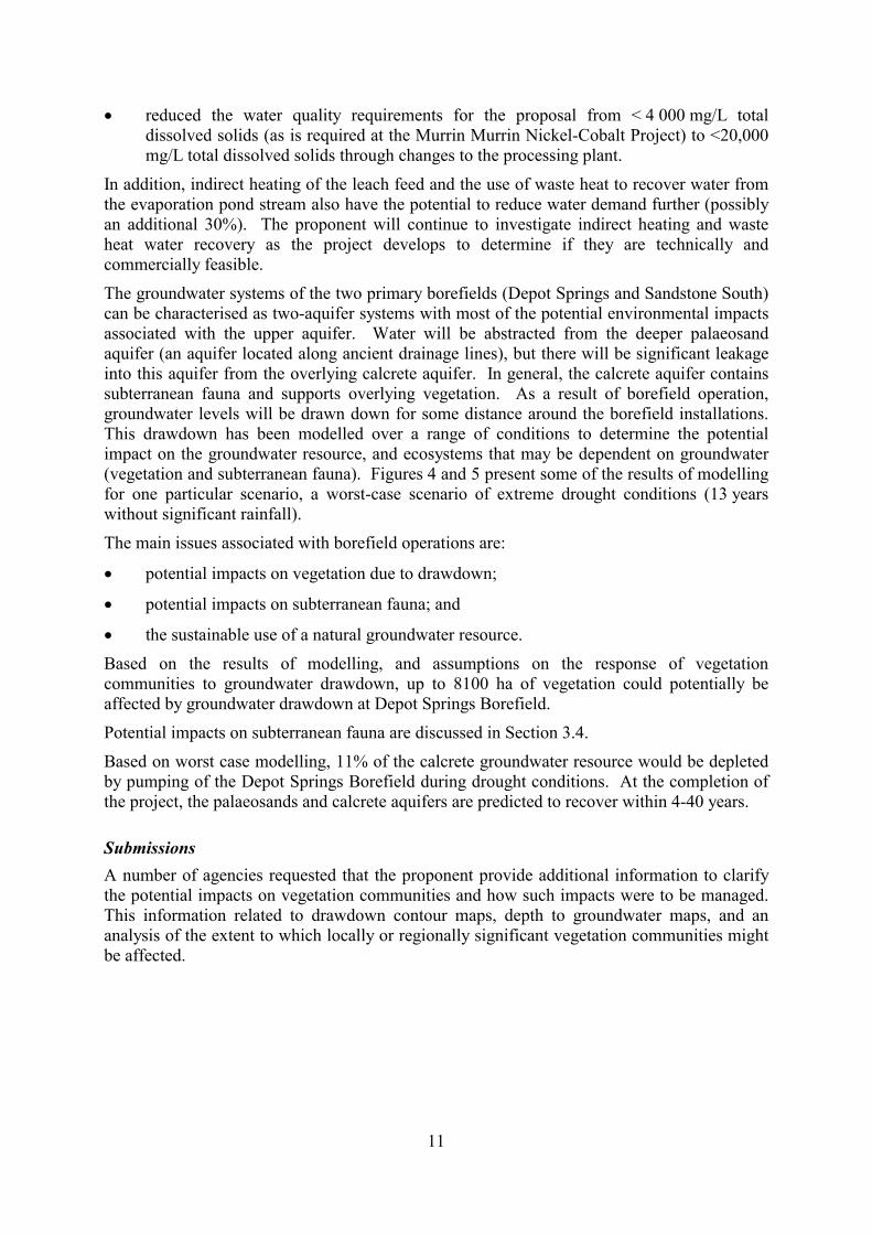
11
�� reduced the water quality requirements for the proposal from < 4 000 mg/L total dissolved solids (as is required at the Murrin Murrin Nickel-Cobalt Project) to <20,000 mg/L total dissolved solids through changes to the processing plant.
In addition, indirect heating of the leach feed and the use of waste heat to recover water from the evaporation pond stream also have the potential to reduce water demand further (possibly an additional 30%). The proponent will continue to investigate indirect heating and waste heat water recovery as the project develops to determine if they are technically and commercially feasible. The groundwater systems of the two primary borefields (Depot Springs and Sandstone South) can be characterised as two-aquifer systems with most of the potential environmental impacts associated with the upper aquifer. Water will be abstracted from the deeper palaeosand aquifer (an aquifer located along ancient drainage lines), but there will be significant leakage into this aquifer from the overlying calcrete aquifer. In general, the calcrete aquifer contains subterranean fauna and supports overlying vegetation. As a result of borefield operation, groundwater levels will be drawn down for some distance around the borefield installations. This drawdown has been modelled over a range of conditions to determine the potential impact on the groundwater resource, and ecosystems that may be dependent on groundwater (vegetation and subterranean fauna). Figures 4 and 5 present some of the results of modelling for one particular scenario, a worst-case scenario of extreme drought conditions (13 years without significant rainfall). The main issues associated with borefield operations are:
�� potential impacts on vegetation due to drawdown;
�� potential impacts on subterranean fauna; and
�� the sustainable use of a natural groundwater resource. Based on the results of modelling, and assumptions on the response of vegetation communities to groundwater drawdown, up to 8100 ha of vegetation could potentially be affected by groundwater drawdown at Depot Springs Borefield. Potential impacts on subterranean fauna are discussed in Section 3.4. Based on worst case modelling, 11% of the calcrete groundwater resource would be depleted by pumping of the Depot Springs Borefield during drought conditions. At the completion of the project, the palaeosands and calcrete aquifers are predicted to recover within 4-40 years.
Submissions A number of agencies requested that the proponent provide additional information to clarify the potential impacts on vegetation communities and how such impacts were to be managed. This information related to drawdown contour maps, depth to groundwater maps, and an analysis of the extent to which locally or regionally significant vegetation communities might be affected.
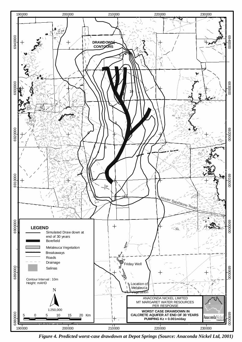
190000
190000
200000
200000
210000
210000
220000
220000
230000
230000
6880
000 6880000
6890
000 6890000
6900
000 6900000
6910
000 6910000
6920
000 6920000
6930
000 6930000
6940
000 6940000
ð
Location of Melaleuca Vegetation
Friday Well
Leinster Sandstone Road
42
0
6
8
1012
DRAWDOWN CONTOURS
BreakawaysRoads
Contour Interval : 10mHeight: mAHD
1:250,000
5 0 5 10 15 20 Km
N
Salinas
Drainage
Melaleuca Vegetation
Borefield
Simulated Draw down at end of 30 years
LEGEND
ANACONDA NICKEL LIMITEDMT MARGARET WATER RESOURCES
PER RESPONSE
WORST CASE DRAWDOWN INCALCRETE AQUIFER AT END OF 30 YEARS
PUMPING Kz = 0.001m/day
Figure 4. Predicted worst-case drawdown at Depot Springs (Source: Anaconda Nickel Ltd, 2001)
Czc
Czs
Czs
Czs
Agm
Czc
Czs
Qa
Agm
Czc
q
Czs
Czs
Agm
Qa
Czk
Czc
CzsCzc
Czc
Czk
Czs
Czs
Qa
Czc
Qa
Agm
Czk
Czs
Agm
Czc
Qa
Czc
Czs
Czk
q
Czs
q
AbifAgm
Qa
q
Abs
Czc
Agm
Qac
Czs
Qa
Abif
Pkc
Pkc
Qa
Agm
Czs
Czc
Abif
Czc
AgmQa
Czc
Abif
Qac
AgmCzsAgm
Qa
Abif
Pkc
Qa
Abs
Czk
Qa
Czc
Czs
Agm Abif
Abif
Agm
Czc
Abs
Czc
Czs
Agm
Agm
Czc
Qa
Agm
Abs
0.1
2
68
44
0.1
0.1
0.1
2
1012
2
6
0.1
4
8
4
60.1
2
200000 mE
200000 mE
220000 mE
220000 mE
180000 mE
6940
000
mN
180000 mE
6940000 mN
6900
000
mN
6920
000
mN
6920000 mN
6840000 mN
6860000 mN
6880000 mN
6900000 mN
6880
000
mN
160000 mE
160000 mE
6840
000
mN
6860
000
mN
140000 mE
140000 mE
Drawing:
Office: Exploration Perth
MT MARGARET - Depot Springs/Sandstone South Borefields
MAR00_Em008_Stygo
Author: D. Humphreys
Scale: 1:500,000
Drawn by: X. Bézu / P. Mastalir
PROJECT:
Date: Apr. 2001
Stygofauna Sample Sites within the Borefields with Geology and Worst Case Drawdown Contours (13 Year)
10 km
Projection AMG 51 (AGD84)
0
Perth
Meekatharra
Kununurra
WESTERNAUSTRALIA
LOCATIONMAP
Port Hedland
PerthKalgoorlie
Leonora Laverton
Esperance
MT MARGARET
GEOLOGY LEGEND
Colluvium – clay silt and sand in extensive reworked fan deposits
Appreciable secondary calcrete and silcrete replacement
Sand plain deposits – unconsolidated aeolean sand, silt and clay
Arkosic sandstone and mudstone
Alluvium – clay silt sand and gravel in channels and floodplains
Quartz reef
Banded iron formation, jasperlite, chert and hematite
Mafic schist after basaltic and mafic volcaniclastics
Clay and silt in clay pans and playas
Fine grained biotite monzogranite
Polymictic conglomerate
Minor Roads
Trunk Line
Drawdown Contours
Geological Fault Line
QUATERNARY
PROTEROZOIC
CAINOZOIC
ARCHEAN
Qac
Qa
q
Pkc
Pks
Czc
Czk
Czs
Abs
Abif
Agm
STYGOFAUNA SURVEY RESULTSDepot Springs & Sandstone Borefield Areas
01 to 9
10 to 1920 to 2930 to 40
SANDSTONESOUTH
DEPOT SPRINGS
N° ofIndividuals
Figure 5. Predicted worst-case drawdown at Sandstone South and stygofauna sampling sites(Source: Anaconda Nickel Ltd, 2001)

14
Most submissions on this factor were made by State and Commonwealth agencies with expertise in groundwater systems (The Waters and Rivers Commission [WRC], and the Bureau of Rural Sciences [BRS]). These submissions were related to various aspects of the groundwater assessment and modelling presented by the proponent in the PER, and the relation of these to sustainable abstraction over the life of the project. In summary, the main points raised were:
�� additional information on the anticipated volumetric and percentage depletion of both the shallow and the deeper aquifers over the projected life of the project (WRC);
�� sensitivity analysis of the computer model developed, including a variation of the parameters used to determine the computer model and likely aquifer recovery of both the shallow and deeper aquifers under different scenarios (WRC and BRS);
�� additional work on the proposed Marshall Creek borefield to allow an informed assessment to be made (WRC and BRS);
�� clarification of the water requirements for the project (WRC);
�� details on the mechanism of recharge from surface water flow and the possible impacts of resultant changes to surface water flow (BRS);
�� substantiation of a claim that recharge would improve water quality of the palaeochannel aquifer (BRS);
�� the definition of sustainable yield and whether the expected depletion of the commandable storage could be classed as sustainable (BRS); and
�� boundary conditions used in the groundwater model (BRS).
In its response to submissions the proponent supplied the WRC and BRS with the additional information requested. This included updated models of groundwater drawdown, sensitivity analysis, and details of the Marshall Creek Borefield. As a result, the EPA understands that the WRC is satisfied with the response, noting that some issues will also be subject of more detailed work throughout the life of the project. It also understands that the residual concerns of BRS have been addressed through clarification of the proponent�s commitments (Appendix 4) and by correspondence from the Department of Minerals and Energy. This correspondence informed BRS that environmental performance bonds for the proposal would include the cost of monitoring borefield recovery after borefield operation ceases.
Assessment The area considered for assessment of this factor is the groundwater systems of the proposed Depot Springs, Sandstone South, Grey Mare, and Marshall Creek borefields.
The EPA�s environmental objectives for this factor are to: (a) maintain the quantity of groundwater so that existing and potential uses, including
ecosystem maintenance, are protected; and (b) maintain or improve the quality of groundwater to ensure that existing and potential
uses, including ecosystem maintenance are protected.
Detailed hydrological information and modelling on the primary borefields has been presented to the WRC, BRS and Environment Australia through the assessment process. The overall opinion of the WRC is that the modelling is as good as can be achieved for this stage of development, and that only operational monitoring is likely to substantially improve the
15
modelling predictions. The EPA notes that detailed hydrological information and modelling is not always required at this stage of a project. However, in this case it has greatly assisted in allowing critical review of this important component of this proposal. In addition, the inclusion of some detailed information on contingency supplies, has also helped to address residual uncertainties inherent to operations of this scale.
Using the predicted drawdown contours, the proponent has also assessed the potential for impacts on vegetation and concluded that the potential impacts would be acceptable. Based on an analysis of the distribution of vegetation communities and risk categorisation of communities with respect to drawdown, no locally or regionally significant vegetation communities are expected to be greatly affected. It should be noted, however, that the intention is that borefield operations will be actively managed to prevent adverse impacts in the first case. This is an appropriate course of action given the large areas of vegetation that appear to be within the influence of worst-case drawdown scenarios. Vegetation monitoring will be carried out over the borefields (Commitment 3.1) and used to trigger management measures through the Borefield Management Plan (Commitment 5.1). Such measures could include: changing the pattern of abstraction within a borefield; irrigating affected vegetation; and/or the development of contingency borefields.
Impacts on subterranean fauna are discussed in Section 3.4, but it is worthwhile to note here that the results of the Subterranean Fauna Management Plan (Commitment 10.1) will also be used to trigger management measures through the Borefield Management Plan.
Sufficient information has been presented to conclude that the proposed borefield operations will be sustainable on a timescale appropriate to the 30-year life of the project. The EPA notes that the WRC is satisfied with the information presented by the proponent on this issue. It also understands that this issue will be continuously monitored throughout borefield operations under the requirements of water abstraction licences.
Given that the scale of the project means that confidence in modelling can only be improved through operational monitoring, there is a need to have in place detailed contingency plans, particularly in the early phases of the project. While contingency borefields have already been identified at this stage, a detailed plan for their development needs to be prepared so that the main borefield abstraction rate could be quickly reduced, if necessary, and replaced by a contingency source. These contingency plans would be triggered by adverse findings from monitoring on any of the three major issues: vegetation, subterranean fauna, or sustainability (refer to Condition 6).
Summary Having particular regard to: (a) the results of the proponent�s groundwater investigations; (b) the contingent water supplies that have been identified; (c) the proponent�s commitments to monitor, report on, and take management measures as
necessary; and (d) the advice of the WRC on the adequacy of the proponents investigations and
conclusions, it is the EPA�s opinion that the proposal can be managed to meet the EPA�s environmental objective for this factor provided a detailed Borefield Contingency Plan is developed prior to commissioning of the project.

16
3.4 Subterranean fauna
Description Subterranean fauna include both troglobites (terrestrial) and stygofauna (aquatic). Both of these are important because of their species richness, evolutionary history and adaptations, and the evidence they can provide for continental drift. Hence they are significant in terms of Australian faunal biodiversity (EPA, 1997). Preliminary surveys of the borefields and calcrete mining area have been carried out. Initial sampling of the Depot Springs, Sandstone South, and Marshall Creek borefields, and the Sturt Meadows calcrete mining area has occurred. The results from these initial surveys have been assessed with reference to other surveys the proponent has carried out at the Murrin Murrin borefield and calcrete areas. Figures 5 and 6 show the location of sampling sites and where stygofauna have been found. Stygofauna have been collected from the calcrete within the Sturt Meadows calcrete resource and in calcretes that form part of the borefield groundwater system. Stygofauna have also been found in the alluvial sands above the palaeochannel aquifers themselves and the silcretes in the Marshall Pool borefield. In summary, the following stygofauna were found:
�� Depot Springs Borefield - Bathynellid syncarida and Harpacticoid copepoda;
�� Sandstone South Borefield - Harpacticoid copepoda;
�� Marshall Creek Borefield - Harpacticoid copepoda; and
�� Sturt Meadows calcrete mining area � Copepoda cycloporda, Copepoda harpachiorda, Amphipod amphipoda.
Potential impacts on stygofauna are related to: �� direct removal of habitat in the calcrete mining area;
�� drawdown of aquifers around borefields and calcrete mining areas; and
�� possible changes in groundwater quality around borefields and the calcrete mining area.
Submissions In summary, the main points raised by CALM were:
�� additional information is needed on current and future work on stygofauna in the region to better determine their presence and habitat, and how adverse impacts can be minimised by management;
�� there should be sufficient flexibility in the operations plan to be able to change procedures or shift to alternative sources of calcrete (or substitutes) and/or water if the preferred options are considered to be a threat to the biodiversity of stygofauna; and
�� additional information is needed on the hydrogeology of the habitat within the calcrete mining area and the extent to which mining operations would affect this habitat.
In summary, the main points raised by the Western Australian Museum were:
�� that the information included in the PER on the stygofauna in the project area was inadequate;

17
�� the project will directly impact on calcrete areas each of which, based on past experience, may contain unique stygofauna communities or species; and
�� the predicted drawdown of 11 m in the Depot Springs calcrete may result in extensive loss of habitat within the confines of locally endemic communities and therefore requires a sophisticated understanding of potential effects of borefield operation on the stygal ecosystems within the calcrete aquifers.
In summary, the main point raised by the WRC was:
�� The significant depletion of the groundwater storage in the calcrete aquifer at the Depot Springs borefield may result in a loss of stygofauna habitat. A more detailed survey needs to be undertaken by the proponent to estimate the number of stygofauna that may be affected compared to the numbers found in the general area of Depot Springs.
In summary, the main points raised by Environment Australia were:
�� It is understood that calcrete formations have been shown to provide important habitat for a very diverse stygofauna community. It is therefore essential that such a diverse community, that exhibits a high degree of endemicity and is under threat from extractive industry including groundwater abstraction, is adequately researched and assessed as part of the PER process.
�� It was expected that the results of preliminary surveys of potential subterranean habitats, and distribution, particularly within the areas that could be affected by borefield development and calcrete mining, would be provided in the PER.
Assessment The areas considered for assessment of this factor are the potential subterranean habitats within the hydraulic influence of the calcrete mining area and the borefields. The EPA�s environmental objectives for this factor are to: (a) maintain the abundance, diversity and geographical distribution of subterranean fauna;
and
(b) improve the understanding of subterranean fauna through appropriate research including sampling, identification and documentation.
In response to the general criticism that the PER contained insufficient information on this factor, the proponent has provided the results of all its survey work to date. It has also provided additional information on the predicted drawdown within the borefields and the management measures that would be applied to the calcrete mining area. In retrospect it would have been preferable for the proponent to have provided more of the information in the PER document. This could have been achieved by initiating subterranean fauna surveys earlier in the development of the proposal, perhaps at the same time, or shortly after, the resource investigation work for the borefields and calcrete areas.
The proponent has also given a number of commitments that aim to improve understanding of stygofauna in this area and to use this information to reduce impacts. The proponent will develop a Subterranean Fauna Management Plan (Commitment 10.1), establish an expert panel to review results and revise the plan (Commitment 10.3), and finance further research to better understand the distribution and significant of stygofauna at the regional level (Commitment 10.4).
18
In summary, much of the comment on this factor by the various submitters reflects the uncertainties associated with this particular factor due to a limited understanding of subterranean fauna in the region, and generally throughout the State. In previous assessments (EPA, 2000) the EPA has commented on the lack of baseline information on the distribution of subterranean fauna, and the almost complete lack of monitoring data on the response of subterranean ecosystems to changes in this environment. Until this situation changes, the EPA must adopt a risk based assessment of this factor that takes into account the distribution information presented at the project level and predicted impacts based on reasonable assumptions on how such ecosystems function. Hence the EPA in its assessment of this proposal will weigh up the risks associated with the limited knowledge available against the benefits that may be gained by additional studies as a result of this proposal proceeding Based on the submissions, the main area of concern appears to be the calcrete mining area. In this area, stygofauna will be affected through the direct removal of habitat by excavation, and through drawdown of the groundwater in the surrounding calcrete habitat by dewatering. It is noted that calcrete areas elsewhere in the State have been found to be important stygofauna habitats and to contain endemic stygofauna communities. In this case, calcrete mining at Sturt Meadows quarry is not expected to have an unacceptable impact on the stygofauna within the larger calcrete resource for the following reasons:
�� the calcrete resource appears to be a single interconnected deposit of 40 km2;
�� it is estimated that only 7-15% of the calcrete habitat occurs within the quarry boundary and would be excavated (see Figure 6);
�� specific measures will be taken to reduce the extent of drawdown from dewatering1; and
�� a layer of calcrete will be left in-situ to ensure a geological and hydraulic connection with the remainder of the calcrete habitat post-mining.
As a result, most of the Sturt meadows calcrete habitat will be unaffected by the mining operation, and so stygofauna communities may be expected to remain viable during mining and be able to recolonise the layer of calcrete left after mining. While there is some residual environmental risk associated with the limited understanding of stygofauna distribution and ecology, there is sufficient flexibility in the proposal to manage this risk. The proponent acknowledges that there are risks associated with developing a proposal while still conducting research on stygofauna. The proponent is therefore aware that if additional studies prove there to be a serious threat to biodiversity of stygofauna in the region, then it will have to initiate changes to its operations. These might include, reducing the extent of disturbance to the calcrete area, reducing the volume of calcrete extracted and sourcing neutralising material from elsewhere.
1 Calcrete will be mined in panels (approximately 100 m by 150 m) and water from dewatering each panel will be pumped to previous mined areas and into a ring around the quarry at a distance of 1 km.

Road
Cross
Jim
W
R A
E S
I D E
L A
K E
WSt
urt M
eado
ws
Hill
B
Y
Rd
Old
Sta
tion
W
Cow
W
Ida
Valle
y
E37/6
45
Cal
cret
e R
esou
rce
Cal
cret
e R
esou
rce
Cal
cret
e R
esou
rce
Cal
cret
e R
esou
rce
Cal
cret
e R
esou
rce
Cal
cret
e R
esou
rce
Cal
cret
e R
esou
rce
Cal
cret
e R
esou
rce
Cal
cret
e R
esou
rce
300000 mE
295000 mE
6815
000
mN
6820
000
mN
6825
000
mN
Tene
men
t out
line
Prop
osed
Cal
cret
e Q
uarry
Cal
cret
e R
esou
rce
Lege
nd Offi
ce: E
xplo
ratio
n Pe
rth
Dra
win
g:
Auth
or: D
.Hum
phre
ys
Sty
gofa
una
Sam
plin
g S
ites
wit
hin
the
Cal
cret
e R
esou
rce
& Q
uarr
y A
reas
MO
UN
T M
ARG
ARET
NIC
KEL-
CO
BALT
PR
OJE
CT
PER
MA
R01
_Ta0
03Sc
ale:
1:7
5,00
0D
ate:
Jan
200
1
Dra
wn
by: P
.Mas
talir
2Km
Proje
ction
AM
G Zo
ne 5
1 (A
GD 8
4)
10
Styg
ofau
na S
urve
y R
esul
tsSt
urt M
eado
ws
0 1 to
9
10 to
19
20 to
29
120º
30'
121º
121º
30'
Figure 6. Sturt Meadows calcrete mining area and stygofauna sampling sites (Source: Anaconda Nickel Ltd, 2001)
30 to
40
Num
ber
of In
divi
dual
s
20
With regard to the impacts of the borefields on stygofauna, impacts are not expect to be great and can be adequately addressed through changes to borefield operation, including the use of contingency borefields. Stygofauna has survived similar borefield operations in the Marshall Creek borefield area as demonstrated by the collection of stygofauna from this area in the recent survey. The Bannockburn Marshall Creek Borefield, which extracted water from the same aquifer as the proposed borefield, was operated from 1992 to 1997 at a similar rate to that proposed for the proponent�s borefield. In addition, the monitoring of stygofauna and stygofauna habitats in the borefields would be incorporated into the borefield management plans. In response to any adverse impacts the pattern of abstraction within the borefield could then be modified, or if impacts were of sufficient concern, then the EPA could require contingency borefields to be developed (Condition 6). Given the importance of this issue and the uncertainties involved, the EPA recommends that further studies set out by the proponent become part of a consolidated Subterranean Fauna Sampling Plan (Condition 8) submitted to the EPA. These studies will add to the understanding of stygofauna in the region and provide baseline information for incorporation into the proponent�s Subterranean Fauna Management Plan. In conclusion, the EPA considers that the collection of additional data as a result of this proposal will add to basic knowledge of stygofauna and hence that there is a reasonable balance between the risk that the EPA�s objective will not be met and the additions to fundamental taxonomic data that will accrue.
Summary Having particular regard to: (a) the results of survey work to date; (b) the proponent�s commitment to undertake sampling within the project area and develop
a specific management plan; and (c) the predicted impacts on known habitats, it is the EPA�s judgement that the balance of the risk that the EPA�s objective is compromised against the benefits of improved basic knowledge of stygofauna is acceptable, provided a thorough study to improve knowledge is conducted and management practices are modified in response to this information.
3.5 Aboriginal heritage and culture
Description The scale and extent of the project across the land has the potential to affect the Aboriginal community�s use of, and relationship with, the land. As noted previously the proposal would disturb a large area (up to 111 km2) spread out over a large distance (approximately 100 km). To varying degrees, project operations would result in restricted access to some areas for the Aboriginal community. The project area includes a number of Aboriginal sites of low to moderate significance. Archaeological and ethnographic surveys have been carried out over most of the project area at an appropriate level of detail. The level of detail was varied in accordance with the potential for disturbance in the area (for example, mining areas were surveyed in more detail than borefield areas). 115 archaeological sites have been found in the Mt Margaret project areas. Most of these sites are either common (quarries and artefact scatters) or small (rock shelters and a standing stone) and so were not considered to be of any major archaeological significance. Ethnographic surveys of the project area carried out with the participation of

21
appropriate Aboriginal informants have identified a number of ethnographic sites within the project area. This work has been used to avoid sites where possible and identify those sites that cannot be avoided. The proponent has obtained approval to disturb those sites that would be affected by the early phases of the project and will continue to consult and negotiate with Aboriginal people on possible disturbance of other sites throughout the life of the project. Clearance has been obtained under Section 18 of the Aboriginal Heritage Act 1972 to disturb 36 archaeological sites and five ethnographic sites in the Marshall Pool project area. The proponent will continue to consult with Aboriginal people in relation to the planning and management of the project to ensure that the risk of unintentional intrusion or damage to Aboriginal sites is minimised. Aboriginal people will also be consulted with regard to any future applications to disturb sites (Commitment 23.1).
Submissions In order to hear first hand any concerns of the local Aboriginal communities with regard to this proposal, the EPA travelled to the project site and met with representatives of the communities on 14-15 December 2000. Through these discussions the Aboriginal people present raised the following issues: 1. The people use much of the land around the project area for hunting and camping, and
would not like to have these activities greatly restricted by the development of the project. Areas of particular importance for these activities are: �� Sturt Meadows; �� Doyle Well; �� Marshall Pool; and �� the land to the west of the Agnew to Leonora gravel road.
2. The people requested assurance that there will be no offsite impacts (such as runoff from the mining area or discharge/seepage from the tailings storage facilities and evaporation ponds) on Marshall Pool itself.
3. The people were concerned that ore stockpiles are planned for areas that contain �wiltja� campsites. This area is on the western side of the ridge that runs along the western limb of the orebody at the Marshall Pool mining area.
4. At both Depot Springs and Sturt Meadows it is important that a species of flora known as wild potato is maintained.
5. Depot Springs and Sandstone South borefields have numerous springs and grasslands dependent on near surface groundwater. It is important that these areas are not adversely affected by drawdown as a result of borefield operations.
The Aboriginal Affairs Department (AAD) commended the proponent�s commitment to ongoing liaison with the Aboriginal community (Commitment 23.1), subject to it being broad enough to address all relevant parties. In particular, a clear indication that representatives for western project areas are involved in a meaningful way should be provided. The AAD also noted that in Section 4.8 of the PER it was stated that �Anaconda is unable to provide reports of the heritage surveys to the contributors because the information is highly sensitive to local Aboriginal people�. In general, the AAD is not of the opinion that the reports contain highly sensitive cultural information.
22
Assessment The area considered for assessment of this factor is the overall project area of the Mt Margaret Project, including mining areas, borefields, and other infrastructure. The EPA�s environmental objectives for this factor are to ensure that: (a) the proposal complies with the requirements of the Aboriginal Heritage Act 1972; (b) changes to the biological and physical environment resulting from the project do not
adversely affect cultural associations with the area; and (c) local communities are adequately consulted in regard to environmental impacts likely to
be of concern to the communities. The EPA believes that the proponent has adequately addressed the concerns of the local Aboriginal people that have been raised so far, and that the establishment of the Mt Margaret Aboriginal Environmental Consultation Committee (MMAECC) will ensure that these and any future issues can continue to be dealt with during the life of the project. A commitment has been given to form the MMAECC along similar lines to the Murrin Murrin Aboriginal Environmental Liaison Committee (Commitment 22.1). In its assessment of the Murrin Murrin Stage 2 Expansion (EPA 1999b) the EPA accepted that adequate consultation would occur if the local Aboriginal communities: (a) are kept informed about the potential and actual environmental impacts of the project; (b) are able to make their concerns in regard to environmental impacts known to the
proponent; and (c) are able to have meaningful input into the proponent�s management of environmental
impacts. Given that these are the objectives of the Murrin Murrin Aboriginal Environmental Liaison Committee, the EPA considers it appropriate that the MMAECC be based on this model. In its response to submissions arising from the EPA�s site visit, the proponent advised that: 1. peoples� access to the land will not be greatly affected, as access will only be restricted
on the basis of safety; 2. preliminary investigations suggest there is little likelihood of Tailings Storage Facilities
and evaporation ponds polluting Marshall Pool, but this will be a key criterion for the detailed design of these facilities;
3. there are no plans to disturb the �wiltja� campsites; 4. extra care will be taken in the assessment and clearing of the wild potato and it will be included
in the mix of plant species used in rehabilitation; and
5. the springs and grasslands are not expected to be affected by the borefield operations, since these are dependent on water systems that are not connected with the groundwater being abstracted.
In addition these, and any other concerns that may arise in the future, will continue to be discussed and dealt with by MMAECC during the life of the project. With regard to comments by the AAD, the MMAECC has been formed with representation of all relevant parties and sufficient information has been made publicly available for the EPA to carry out its assessment of this factor.
23
A public meeting was held in Leonora on 4 April 2001 to select committee members for the MMAECC. At the meeting it was agreed that the selected membership gives adequate representation to people of those areas that are likely to be affected by the proposal. Should particular options in more western areas be adopted later, then the membership would be reviewed at that time. In its response to submissions, the proponent maintains that some heritage survey reports are sensitive and that it does not wish to be responsible for distributing sensitive material too widely. For this assessment, the EPA considers that the information in the PER was sufficient for it to assess the proposal and to allow informed comment from the public. The conduct of Aboriginal heritage surveys and the feedback of information to Aboriginal participants in the future, is a matter for the proponent and the AAD to determine, given that such surveys are required to demonstrate compliance with the Aboriginal Heritage Act 1972. It would also seem to be a subject suitable for discussion within the MMAECC.
Summary Having particular regard to the: (a) submissions received from representatives of the Aboriginal communities; (b) the proponent�s response to these submissions; and (c) the proponents commitment to establish a meaningful consultation committee, it is the EPA�s opinion the proposal is capable of being managed to meet the EPA�s objectives for this factor.
4. Conditions and commitments Section 44 of the Environmental Protection Act 1986 requires the EPA to report to the Minister for the Environment and Heritage on the environmental factors relevant to the proposal and on the conditions and procedures to which the proposal should be subject, if implemented. In addition, the EPA may make recommendations as it sees fit. In developing recommended conditions for each project, the EPA�s preferred course of action is to have the proponent provide an array of commitments to ameliorate the impacts of the proposal on the environment. The commitments are considered by the EPA as part of its assessment of the proposal and, following discussion with the proponent, the EPA may seek additional commitments. The EPA recognises that not all of the commitments are written in a form which makes them readily enforceable, but they do provide a clear statement of the action to be taken as part of the proponent�s responsibility for, and commitment to, continuous improvement in environmental performance. The commitments, modified if necessary to ensure enforceability, then form part of the conditions to which the proposal should be subject, if it is to be implemented.
4.1 Proponent�s commitments The proponent�s commitments as set in the PER, and subsequently modified as shown in Appendix 4, should be made enforceable.

24
4.2 Recommended conditions Having considered the proponent�s commitments and the information provided in this report, the EPA has developed a set of conditions that the EPA recommends be imposed if the proposal by Anaconda Nickel Ltd to develop the Mt Margaret Nickel-Cobalt Project is approved for implementation. These conditions are presented in Appendix 4. Matters addressed in the conditions include the following: (a) that the proponent shall fulfil the commitments in the Consolidated Commitments
statement set out as an attachment to the recommended conditions in Appendix 4; (d) that the proponent be required to prepare and implement a Subterranean Fauna
Sampling Plan, Borefield Contingency Plan and Significant Flora Management Plan for the proposal; and
(c) that standard conditions appropriate to mining and processing operations of this scale and type be applied.
It should be noted that other regulatory mechanisms relevant to the proposal are: � licensing of the operations under Part V of the Environmental Protection Act 1986; � approvals required under the Mining Act 1978; and � licensing of the operations under the Rights in Water and Irrigation Act 1914.
5. Conclusions The EPA has considered the proposal by Anaconda Nickel Ltd to develop the Mt Margaret Nickel-Cobalt Project. Based on the relevant factors listed above, the EPA concludes that the key issues associated with the proposal are clearing of up to 11,100 ha of native vegetation over ~ 30 years and the management of significant flora, the abstraction and use of 50 million litres of groundwater per day, management of surrounding areas for regional conservation, and the protection of subterranean fauna, and Aboriginal heritage and culture. In considering these issues, the EPA noted that: � the proponent will rehabilitate areas disturbed under the proposal under an integrated
mining and rehabilitation plan, which will evaluate opportunities over the life of the project (through five-yearly reviews) to reduce the long-term changes to the land through backfilling pits and in-pit disposal of tailings;
� the State agencies responsible for regional conservation, significant flora species, water resources, subterranean fauna, and Aboriginal heritage and culture have been extensively consulted on the proposal, and are satisfied with the information provided to date; and
� the proponent has consulted with other stakeholders in the project, including Aboriginal communities and pastoral lease owners in the area of the project, and has established appropriate and meaningful routes for ongoing consultation.
The EPA commends the proponent for its commitment to provide for long-term regional conservation, and is very optimistic that the proponent, in collaboration with CALM, will develop a strategy that can provide lasting conservation benefits for the region.
25
With regard to the water requirements for the proposal, the EPA considers that the proponent has assessed, as far as possible prior to actual groundwater abstraction, the proposals affect on groundwater systems. The EPA has concluded that the proposal is capable of being managed to meet the EPA�s objectives provided there is satisfactory implementation by the proponent of the proponent�s commitments and the recommended conditions set out in Appendix 4 and summarised in Section 4.
6. Recommendations The EPA submits the following recommendations to the Minister for the Environment and Heritage. 1. That the Minister notes that the proposal being assessed is for development of the Mt
Margaret Nickel-Cobalt Project, located approximately 300 kilometres north of Kalgoorlie.
2. That the Minister considers the report on the relevant environmental factors as set out in Section 3.
3. That the Minister notes that the EPA has concluded that it is unlikely that the EPA�s objectives would be compromised, provided there is satisfactory implementation by the proponent of the recommended conditions set out in Appendix 4, and summarised in Section 4, including the proponent�s commitments.
4. That the Minister imposes the conditions and procedures recommended in Appendix 4 of this report.

Appendix 1
List of submitters

Organisations: Aboriginal Affairs Department Department of Conservation and Land Management Department of Environmental Protection Department of Minerals and Energy Department of Resources Development Environment Australia Goldfields Land Council Health Department of Western Australia Shire of Sandstone Water Corporation Water and Rivers Commission Western Australian Museum Wildflower Society of Western Australia Individuals: PA Kelly PD, FS and WP Axford (�Sturt Meadows�) Two confidential submissions

Appendix 2
References

Anaconda Nickel Limited (2001). Mt Margaret Nickel-Cobalt Project, Proponent�s Response to Public Environmental Report and Public Environmental Review submissions. Anaconda Nickel Limited, May 2001. Perth WA. Environmental Protection Authority (1997), Extensions to Exmouth Marina Harbour, Landcorp: report and recommendations of the Environmental Protection Authority. Environmental Protection Authority Bulletin 868, November 1997. Perth WA. Environmental Protection Authority (1999b). Murrin Murrin Nickel-Cobalt Project Stage 2 Expansion, 60 km east of Leonora: report and recommendations of the Environmental Protection Authority, Environmental Protection Authority Bulletin 931, March 1999. Perth WA. Environmental Protection Authority (2000). Nammuldi-Silvergrass Iron Ore Project, 55 km north-west of Tom Price: report and recommendations of the Environmental Protection Authority, Environmental Protection Authority Bulletin 996, October 2000. Perth WA. URS (2000). Mt Margaret Nickel-Cobalt Project, Public Environmental Report/Public Environmental Review. Prepared by URS for Anaconda Nickel Limited, December 2000. Perth WA. Dames & Moore (2000). Geraldton to Mt Margaret Natural gas Pipeline � Vegetation Survey of the Northern Route. Prepared for Anaconda Nickel Limited. Perth WA. (Cited in URS, 2000). Florabase (March, 2001) www.florabase.calm.wa.gov.au. (Cited in Anaconda Nickel Limited, 2001). Landcare Services (1997). Marshall Pool Baseline Flora, Vegetation and Habitat Mapping Survey, August 1997. Report prepared for Anaconda Nickel Ltd. Perth WA. (Cited in URS, 2000). Mattiske Consulting Pty Ltd. (2000). Flora and Vegetation Survey: Mt Margaret Project. Report. Report prepared for Anaconda Nickel Ltd. Perth WA.

Appendix 3
Summary of identification of relevant environmental factors

Appendix 3: Summary of identification of relevant environmental factors
Preliminary Environmental
Factors Proposal Characteristics
Government Agency and Public Comments Identification of Relevant
Environmental Factors
BIOLOGICAL DIVERSITY AND REGIONAL CONSERVATION
Vegetation communities
The proposal involves clearing of up to 11,100 ha of vegetation (assuming no in-pit disposal of waste); 86% of this clearing is for pits and waste disposal, with the remainder for infrastructure.
Vegetation may also be disturbed by changes in drainage patterns, the introduction/spread of weeds and groundwater drawdown, e.g. based on average operating and climatic conditions, there is a �reasonable potential� that up to 8100 ha of vegetation will be affected by groundwater drawdown at Depot Springs Borefield. The proposal will impact 22 vegetation communities in which Priority and other significant flora species have been recorded. Of these communities, 5 are restricted to the Marshall Pool area and occur largely on the orebodies or the site of the processing plant.
Six regionally significant communities associated with breakaways or other rocky landforms are present in the Project Area but will remain undisturbed.
DEP: Additional information is required on the disturbance to locally significant vegetation communities. A number of locally and regionally significant vegetation communities will be potentially affected by groundwater drawdown from the proposal (pg 79 & Table 19 of PER). What area of each of these vegetation communities (and also as a percentage of the total survey area) will be potentially affected by the groundwater drawdown?
CALM: The proponent should make a commitment to liaise with the Forest Products Commission to facilitate the salvage of valuable timbers in advance of clearing.
WRC: The predicted drawdown in the calcrete aquifer after 30 years of pumping is considered significant with the potential to adversely affect the local flora and fauna. A map showing the depth to the watertable in and around the Depot Springs borefield should be provided, to assist in determining the likely areas where adverse impacts to the local fauna and flora that depend on the shallow watertable may be expected.
DME: Additional information on weed management is needed in the Environmental Management Plan (EMP). Remnant blocks of vegetation should be retained as islands within the areas being mined for calcrete.
Public: As the project area contains significant vegetation and priority flora, the proponent must put more efforts into vegetation management and minimisation of disturbance. In its preparation of the EMP, the proponent should conduct extensive consultation with the DEP, CALM and experts on the vegetation in the region.
Weed infestations should be eradicated.
No regionally significant vegetation communities will be directly affected by the proposal.
Eight vegetation communities, which were identified as being locally significant due to containing Priority flora, will be affected by the proposal at Marshall Pool mining area. As these communities are not considered to be structurally or biologically diverse, and all flora species within the communities are known to occur outside the mining area, the proposal is unlikely to have an unacceptable impact on biodiversity.
Vegetation loss due to clearing for mining and infrastructure, and weed management will be addressed under the project�s Environmental Management Plan (EMP), which is to be prepared on the advice of DEP, CALM and DME (Commitment 1.1).
Potential for vegetation loss due to borefield operation requires further evaluation.
Considered to be a relevant environmental factor and is discussed under the factor of �Borefield Operation� .
Declared Rare and Priority flora, and other flora of conservation significance
No Declared Rare Flora was found in the Project Area. Also, no taxa listed under the EPBC Act were recorded in the Project Area.
In total, 11 Priority, and two undescribed flora species, occur within the Project Area.
The proposal will disturb five Priority flora species, and the two undescribed flora species.\
CALM: More detailed information is required on the proposal�s disturbance of Priority flora species.
Environment Australia: Trials should be conducted with Priority and endemic species in consultation with specialist horticulturalists.
Considered a relevant environmental factor.
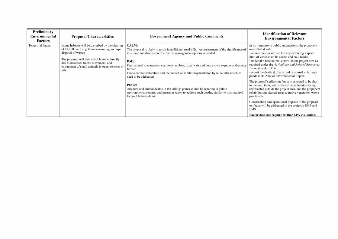
Preliminary Environmental
Factors Proposal Characteristics
Government Agency and Public Comments Identification of Relevant
Environmental Factors
Terrestrial Fauna Fauna habitats will be disturbed by the clearing of 11,100 ha of vegetation (assuming no in-pit disposal of waste).
The proposal will also affect fauna indirectly due to increased traffic movement, and entrapment of small animals in open trenches or pits.
CALM: The proposal is likely to result in additional road kills. An assessment of the significance of this issue and discussion of effective management options is needed. DME: Feral animal management e.g. goats, rabbits, foxes, cats and house mice requires addressing further. Fauna habitat restoration and the impact of habitat fragmentation by mine infrastructure need to be addressed. Public: Any bird and animal deaths in the tailings ponds should be reported in public environmental reports, and measures taken to address such deaths, similar to that required for gold tailings dams.
In its response to public submissions, the proponent noted that it will: � reduce the risk of road kills by enforcing a speed limit of vehicles on its access and haul roads; � undertake feral animal control in the project area as required under the Agriculture and Related Resources Protection Act 1976; � report the death(s) of any bird or animal in tailings ponds in its Annual Environmental Report.
The proposal�s affect on fauna is expected to be short to medium term, with affected fauna habitats being represented outside the project area, and the proponent rehabilitating cleared areas to native vegetation where practicable.
Construction and operational impacts of the proposal on fauna will be addressed in the project�s EMP and EMS.
Factor does not require further EPA evaluation.
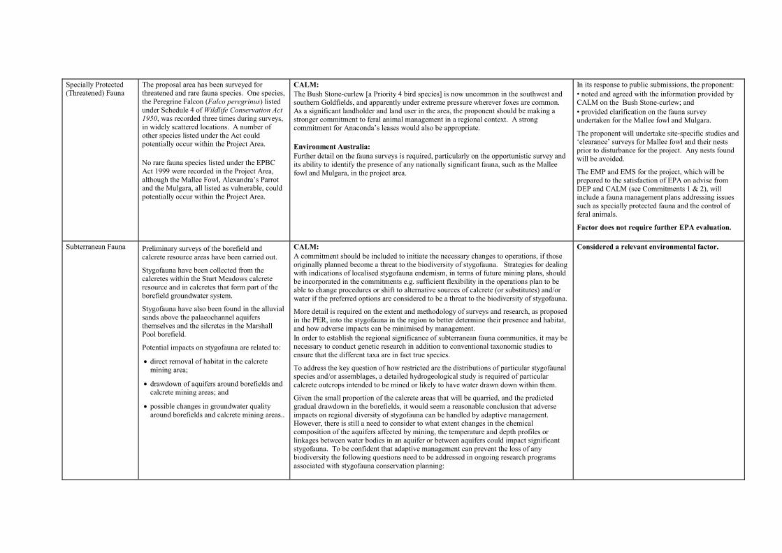
Specially Protected (Threatened) Fauna
The proposal area has been surveyed for threatened and rare fauna species. One species, the Peregrine Falcon (Falco peregrinus) listed under Schedule 4 of Wildlife Conservation Act 1950, was recorded three times during surveys, in widely scattered locations. A number of other species listed under the Act could potentially occur within the Project Area. No rare fauna species listed under the EPBC Act 1999 were recorded in the Project Area, although the Mallee Fowl, Alexandra�s Parrot and the Mulgara, all listed as vulnerable, could potentially occur within the Project Area.
CALM: The Bush Stone-curlew [a Priority 4 bird species] is now uncommon in the southwest and southern Goldfields, and apparently under extreme pressure wherever foxes are common. As a significant landholder and land user in the area, the proponent should be making a stronger commitment to feral animal management in a regional context. A strong commitment for Anaconda�s leases would also be appropriate. Environment Australia: Further detail on the fauna surveys is required, particularly on the opportunistic survey and its ability to identify the presence of any nationally significant fauna, such as the Mallee fowl and Mulgara, in the project area.
In its response to public submissions, the proponent: � noted and agreed with the information provided by CALM on the Bush Stone-curlew; and � provided clarification on the fauna survey undertaken for the Mallee fowl and Mulgara.
The proponent will undertake site-specific studies and �clearance� surveys for Mallee fowl and their nests prior to disturbance for the project. Any nests found will be avoided.
The EMP and EMS for the project, which will be prepared to the satisfaction of EPA on advise from DEP and CALM (see Commitments 1 & 2), will include a fauna management plans addressing issues such as specially protected fauna and the control of feral animals.
Factor does not require further EPA evaluation.
Subterranean Fauna Preliminary surveys of the borefield and calcrete resource areas have been carried out.
Stygofauna have been collected from the calcretes within the Sturt Meadows calcrete resource and in calcretes that form part of the borefield groundwater system.
Stygofauna have also been found in the alluvial sands above the palaeochannel aquifers themselves and the silcretes in the Marshall Pool borefield.
Potential impacts on stygofauna are related to:
�� direct removal of habitat in the calcrete mining area;
�� drawdown of aquifers around borefields and calcrete mining areas; and
�� possible changes in groundwater quality around borefields and calcrete mining areas..
CALM: A commitment should be included to initiate the necessary changes to operations, if those originally planned become a threat to the biodiversity of stygofauna. Strategies for dealing with indications of localised stygofauna endemism, in terms of future mining plans, should be incorporated in the commitments e.g. sufficient flexibility in the operations plan to be able to change procedures or shift to alternative sources of calcrete (or substitutes) and/or water if the preferred options are considered to be a threat to the biodiversity of stygofauna.
More detail is required on the extent and methodology of surveys and research, as proposed in the PER, into the stygofauna in the region to better determine their presence and habitat, and how adverse impacts can be minimised by management. In order to establish the regional significance of subterranean fauna communities, it may be necessary to conduct genetic research in addition to conventional taxonomic studies to ensure that the different taxa are in fact true species.
To address the key question of how restricted are the distributions of particular stygofaunal species and/or assemblages, a detailed hydrogeological study is required of particular calcrete outcrops intended to be mined or likely to have water drawn down within them.
Given the small proportion of the calcrete areas that will be quarried, and the predicted gradual drawdown in the borefields, it would seem a reasonable conclusion that adverse impacts on regional diversity of stygofauna can be handled by adaptive management. However, there is still a need to consider to what extent changes in the chemical composition of the aquifers affected by mining, the temperature and depth profiles or linkages between water bodies in an aquifer or between aquifers could impact significant stygofauna. To be confident that adaptive management can prevent the loss of any biodiversity the following questions need to be addressed in ongoing research programs associated with stygofauna conservation planning:
Considered a relevant environmental factor.
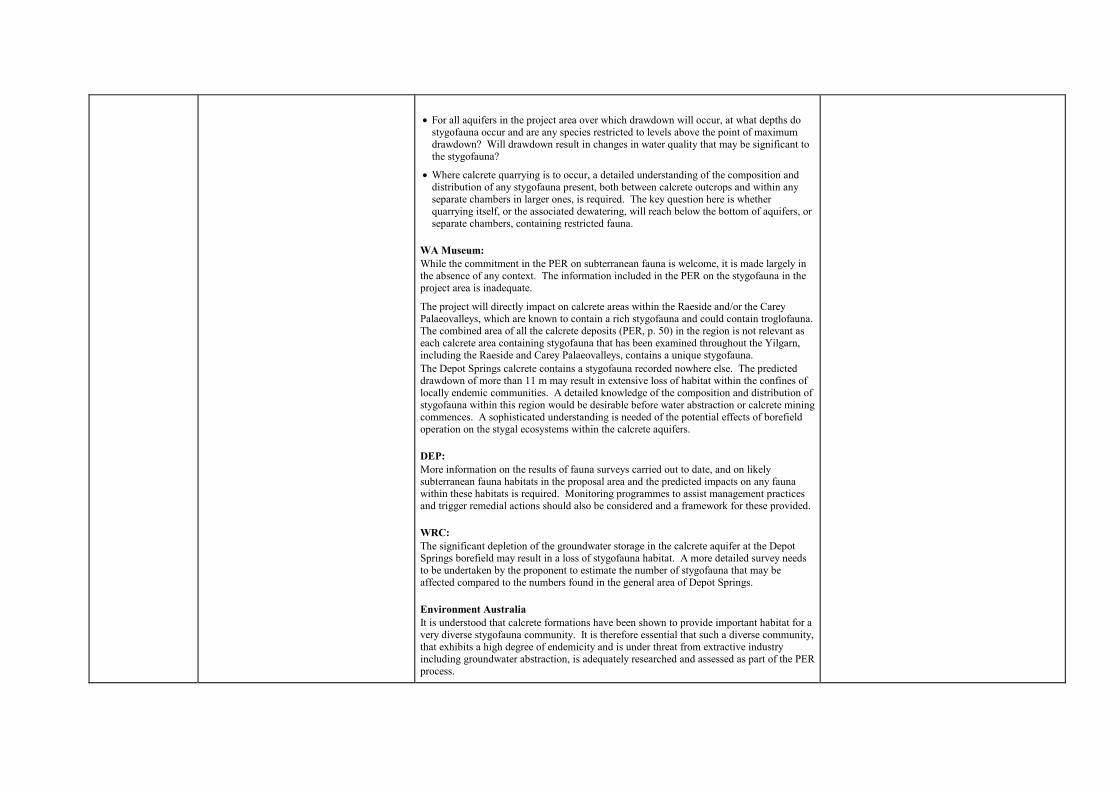
��For all aquifers in the project area over which drawdown will occur, at what depths do
stygofauna occur and are any species restricted to levels above the point of maximum drawdown? Will drawdown result in changes in water quality that may be significant to the stygofauna?
��Where calcrete quarrying is to occur, a detailed understanding of the composition and distribution of any stygofauna present, both between calcrete outcrops and within any separate chambers in larger ones, is required. The key question here is whether quarrying itself, or the associated dewatering, will reach below the bottom of aquifers, or separate chambers, containing restricted fauna.
WA Museum: While the commitment in the PER on subterranean fauna is welcome, it is made largely in the absence of any context. The information included in the PER on the stygofauna in the project area is inadequate.
The project will directly impact on calcrete areas within the Raeside and/or the Carey Palaeovalleys, which are known to contain a rich stygofauna and could contain troglofauna. The combined area of all the calcrete deposits (PER, p. 50) in the region is not relevant as each calcrete area containing stygofauna that has been examined throughout the Yilgarn, including the Raeside and Carey Palaeovalleys, contains a unique stygofauna. The Depot Springs calcrete contains a stygofauna recorded nowhere else. The predicted drawdown of more than 11 m may result in extensive loss of habitat within the confines of locally endemic communities. A detailed knowledge of the composition and distribution of stygofauna within this region would be desirable before water abstraction or calcrete mining commences. A sophisticated understanding is needed of the potential effects of borefield operation on the stygal ecosystems within the calcrete aquifers. DEP: More information on the results of fauna surveys carried out to date, and on likely subterranean fauna habitats in the proposal area and the predicted impacts on any fauna within these habitats is required. Monitoring programmes to assist management practices and trigger remedial actions should also be considered and a framework for these provided. WRC: The significant depletion of the groundwater storage in the calcrete aquifer at the Depot Springs borefield may result in a loss of stygofauna habitat. A more detailed survey needs to be undertaken by the proponent to estimate the number of stygofauna that may be affected compared to the numbers found in the general area of Depot Springs. Environment Australia It is understood that calcrete formations have been shown to provide important habitat for a very diverse stygofauna community. It is therefore essential that such a diverse community, that exhibits a high degree of endemicity and is under threat from extractive industry including groundwater abstraction, is adequately researched and assessed as part of the PER process.

It was expected that the results of preliminary surveys of potential subterranean habitats, and distribution, particularly within the areas that could be affected by borefield development and calcrete mining, would be provided in the PER.
Wetlands � salt lakes The Sturt Meadows calcrete resource is located 3.5 km from the edge of Lake Raeside. Mining of the calcrete is expected to have minimal impact on the lake.
DEP: More baseline information is needed on Lakes Miranda and Raeside, and on the proposal�s potential affect on these lakes. Public: What happens if there is an environmental disaster e.g. a major spillage of toxic waste flooding into the Sturt Meadows Drainage System, and going onto Lake Raeside.
The proposed calcrete mine near Lake Raeside should be fenced. Excess water from the mine should be pumped via pipeline to the salt lake and not disposed of into areas around the perimeter of the lake. Environment Australia: The reasons for selecting the Miranda and Sturt Meadows calcrete resources over other calcrete areas should be provided.
The proposed mining of calcrete for the project is likely to have potential impacts on ecological, hydrological and heritage value of the salt lake systems.
In its response to public submissions, the proponent noted that: � calcrete mining would not now occur near Lake Miranda, and that the area required for mining at the Sturt Meadows calcrete resource had been reduced from 15 km2 to 3 km2; � the project will not generate any toxic waste, and that all infrastructure, such as tailings dams, will be constructed to minimise the risk of failure and any environmental disasters; � public and stock access to the active areas of the calcrete mine will be restricted, and will contain dewatering water within mined panels and a ring main around each year�s quarry; � it considered a wide range of options before selecting the Sturt Meadows site, and that any affects of mining calcrete 3.5 km from the edge of Lake Raeside are likely to be minimal.
The proposed Sturt Meadows calcrete mining area will occupy a small (less than 0.01%) of the catchment of Lake Raeside, and is unlikely to have any offsite impacts that would affect the Lake. No large scale storage of tailings or process chemicals will occur adjacent to Lake Raeside.
Factor does not require further EPA evaluation. Regional Conservation The proposal would disturb a large area (up to
111 km2) spread out over a large distance (~100 km) with much of the disturbance located within laterite soils. It therefore has the potential to have a significant regional impact on land systems affected by this type of mining and affect regional conservation values. While land systems analysis indicates that impacts would not be regionally significant, at a local level the disturbance is considerable. The proponent intends to offset impacts due to the large scale of the project by enhancing the conservation values within pastoral leases that it controls.
DEP: Anaconda�s discussions with CALM to manage, for conservation, parts of pastoral lease areas under its control, is a fine initiative that may have lasting benefits for the environment, both through enhancement of regional conservation and through carbon sequestration. Could more information be provided on the specific objectives of the proposed management and the process currently envisaged to achieve these objectives? CALM: The land systems within the nickel laterite orebody areas (PER, Table 22) and the proposed calcrete mining areas are not adequately represented in the current reserve system within the Murchison biogeographic region. There would be clear conservation benefits from commitments to include representative areas within the conservation reserve system and/or permanent off-reserve conservation measures.
The Regional Conservation Commitment (No. 12.1) needs to be reworded to accurately reflect the intent and the progress made in reaching the desired outcome.
Considered a relevant environmental factor.
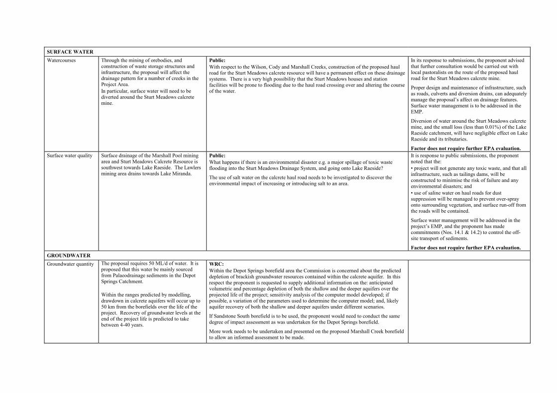
SURFACE WATER
Watercourses Through the mining of orebodies, and construction of waste storage structures and infrastructure, the proposal will affect the drainage pattern for a number of creeks in the Project Area. In particular, surface water will need to be diverted around the Sturt Meadows calcrete mine.
Public: With respect to the Wilson, Cody and Marshall Creeks, construction of the proposed haul road for the Sturt Meadows calcrete resource will have a permanent effect on these drainage systems. There is a very high possibility that the Sturt Meadows houses and station facilities will be prone to flooding due to the haul road crossing over and altering the course of the water.
In its response to submissions, the proponent advised that further consultation would be carried out with local pastoralists on the route of the proposed haul road for the Sturt Meadows calcrete mine.
Proper design and maintenance of infrastructure, such as roads, culverts and diversion drains, can adequately manage the proposal�s affect on drainage features. Surface water management is to be addressed in the EMP.
Diversion of water around the Sturt Meadows calcrete mine, and the small loss (less than 0.01%) of the Lake Raeside catchment, will have negligible effect on Lake Raeside and its tributaries.
Factor does not require further EPA evaluation. Surface water quality Surface drainage of the Marshall Pool mining
area and Sturt Meadows Calcrete Resource is southwest towards Lake Raeside. The Lawlers mining area drains towards Lake Miranda.
Public: What happens if there is an environmental disaster e.g. a major spillage of toxic waste flooding into the Sturt Meadows Drainage System, and going onto Lake Raeside?
The use of salt water on the calcrete haul road needs to be investigated to discover the environmental impact of increasing or introducing salt to an area.
It is response to public submissions, the proponent noted that the: � project will not generate any toxic waste, and that all infrastructure, such as tailings dams, will be constructed to minimise the risk of failure and any environmental disasters; and � use of saline water on haul roads for dust suppression will be managed to prevent over-spray onto surrounding vegetation, and surface run-off from the roads will be contained.
Surface water management will be addressed in the project�s EMP, and the proponent has made commitments (Nos. 14.1 & 14.2) to control the off-site transport of sediments.
Factor does not require further EPA evaluation. GROUNDWATER
Groundwater quantity The proposal requires 50 ML/d of water. It is proposed that this water be mainly sourced from Palaeodrainage sediments in the Depot Springs Catchment. Within the ranges predicted by modelling, drawdown in calcrete aquifers will occur up to 50 km from the borefields over the life of the project. Recovery of groundwater levels at the end of the project life is predicted to take between 4-40 years.
WRC: Within the Depot Springs borefield area the Commission is concerned about the predicted depletion of brackish groundwater resources contained within the calcrete aquifer. In this respect the proponent is requested to supply additional information on the: anticipated volumetric and percentage depletion of both the shallow and the deeper aquifers over the projected life of the project; sensitivity analysis of the computer model developed; if possible, a variation of the parameters used to determine the computer model; and, likely aquifer recovery of both the shallow and deeper aquifers under different scenarios.
If Sandstone South borefield is to be used, the proponent would need to conduct the same degree of impact assessment as was undertaken for the Depot Springs borefield.
More work needs to be undertaken and presented on the proposed Marshall Creek borefield to allow an informed assessment to be made.
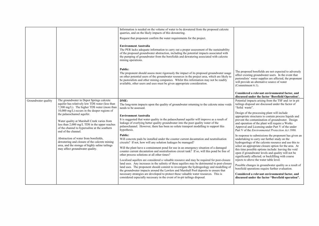
Information is needed on the volume of water to be dewatered from the proposed calcrete quarries, and on the likely impacts of this dewatering.
Request that proponent confirm the water requirements for the project. Environment Australia The PER lacks adequate information to carry out a proper assessment of the sustainability of the proposed groundwater abstraction, including the potential impacts associated with the pumping of groundwater from the borefields and dewatering associated with calcrete mining operations.
Public: The proponent should assess more rigorously the impact of its proposed groundwater usage on other potential users of the groundwater resources in the project area, which are likely to be pastoralists and other mining companies. Whilst this information may not be readily available, other users and uses must be given appropriate consideration.
The proposed borefields are not expected to adversely affect existing groundwater users. In the event that pastoralists� water supplies are affected, the proponent will provide an alternative source of water (Commitment 6.1). Considered a relevant environmental factor, and discussed under the factor �Borefield Operation�.
Groundwater quality The groundwater in Depot Springs calcrete aquifer has relatively low TDS water (less than 7,500 mg/L). The higher TDS water (more than 10,000 mg/L) occurs in the deeper regions of the palaeochannel aquifer. Water quality at Marshall Creek varies from less than 2,000 mg/L TDS in the upper reaches of the channel to hypersaline at the southern end of the channel. Abstraction of water from borefields, dewatering and closure of the calcrete mining area, and the storage of highly saline tailings may affect groundwater quality.
DME: The long-term impacts upon the quality of groundwater returning to the calcrete mine voids needs to be assessed. Environment Australia It is suggested that water quality in the palaeochannel aquifer will improve as a result of leakage of overlying better quality groundwater into the poor quality water of the palaeochannel. However, there has been no solute transport modelling to support this hypothesis.
Public: Will concrete pads be installed under the counter current decantation and neutralisation circuits? If not, how will any solution leakages be managed?
Will the plant have a containment pond for use in an emergency situation of a damaged counter current decantation and neutralisation circuit tank? If so, will this pond be free of other process solutions at all other times?
Localised aquifers are considered a valuable resource and may be required for post-closure land uses. Any increases in the salinity of these aquifers may be detrimental to post-closure land uses. The proponent should commit to investigate the hydrogeology and modelling of the groundwater impacts around the Lawlers and Marshall Pool deposits to ensure that necessary strategies are developed to protect these valuable water resources. This is considered especially necessary in the event of in-pit tailings disposal.
Potential impacts arising from the TSF and /or in pit tailings disposal are discussed under the factor of �Solid waste�.
Design of the processing plant will include appropriate structures to contain process liquids and prevent the contamination of groundwater. Design and operation of the plant will require a Works Approval and Licensing under Part V of the under Part V of the Environmental Protection Act 1986.
In response to submissions the proponent has given an undertaking to carry out further study on the hydrogeology of the calcrete resource and use this to select an appropriate closure option for the area. At this time possible options include: leaving the void open if groundwater levels and quality will not be significantly affected; or backfilling with coarse rejects to above the water table level.
Possible changes in groundwater quality as a result of borefield operations require further evaluation.
Considered a relevant environmental factor, and discussed under the factor �Borefield operation�.

ATMOSPHERIC EMISSIONS
Odour The proposal does not require hydrogen sulphide, and it is expected that any other odour emissions from the proposal will be small. The closest residence to the Mt Margaret processing plant is the accommodation village, which will be located approximately 8 km from the plant site.
No comments received. In comparison with the Murrin Murrin Project (which uses hydrogen sulphide) the Mt Margaret proposal is considered to have little potential to generate odours.
The project is also sufficiently remote from any residences that any odours generated by the proposal are unlikely to have a discernable effect.
Factor does not require further EPA evaluation.
Particulates / Dust Dust will be generated in the clearing of vegetation and stripping of topsoil.
Ongoing dust generation will be predominantly due to mining and the movement of mobile equipment.
The closest residence to the Mt Margaret mine is the accommodation village, which will be located approximately 5 km from the nearest mining area.
DEP: Table 7 of the PER lists the geochemical characteristics of the beneficiated ore and includes arsenic, chromium and manganese, as well as nickel and cobalt. Additional information is required on the fate of these metals in the refining process, and whether they are released to the atmosphere.
The proponent advised that the processing operation does concentrate the metals in the ore, and that the unwanted elements are either recycled back through the process or sent to the tailings stream. No discharges of these elements are vented to the atmosphere.
A DEP pollution prevention licence will apply to the proposal, and that can specify management and limits to manage/control dust generation. The proponent is also required to comply with the requirements of the Department of Minerals and Energy with regard to dust.
Factor does not require further EPA evaluation. Gases � SO2, NOx SO2 and NOx gases will be emitted from the
proposed plant.
The closest residence to the Mt Margaret processing plant is the accommodation village, which will be located approximately 8 km from the plant site.
DEP: Additional detail is required on the atmospheric modelling conducted for the proposal. Public: The PER states that there will be six acid plant start-ups per year per plant (Table 11). How does this frequency of start-ups compare to Murrin Murrin? Any start-up over and above six should be reported on in a public environmental report.
The appropriateness of using the Kalgoorlie meteorological data set is questioned given the significant distance between Kalgoorlie and the Mt Margaret Project. It would be preferable that the proponent use more localised meteorological data, where it is available, for neighbouring operations or the Leinster airport.
Given the additional information provided by the proponent, the DEP considers that the atmospheric modelling undertaken by the proponent for predicting potential off-site gas concentrations is adequate.
In response to other public submissions, the proponent noted that: � the six acid plant start-ups per year expected for the proposal is an improvement on Murrin Murrin, and, the number of start-ups per year will be reported to the regulatory authorities; and � it was unable to obtain local meteorological data of suitable quality for the modelling.
The predicted concentrations of SO2 and NOx at the project�s accommodation village were predicted to be well below standards set in the Ambient Air Quality National Environment Protection Measure guidelines.
Factor does not require further EPA evaluation.
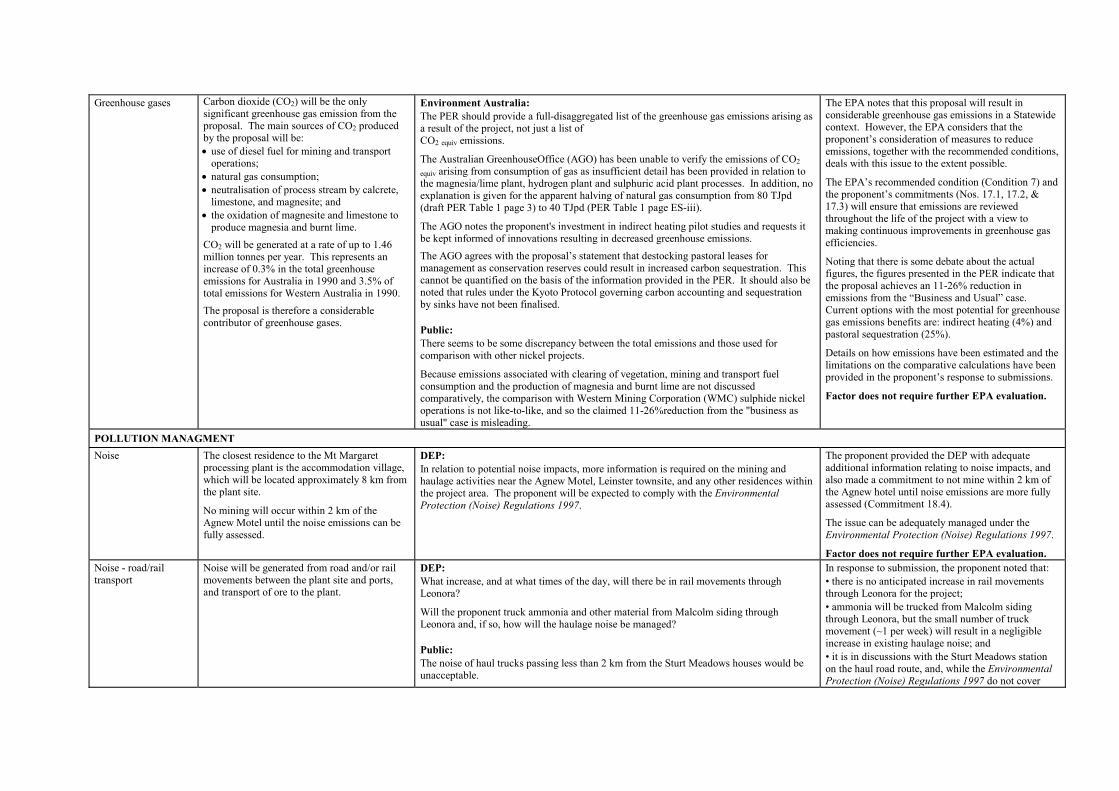
Greenhouse gases Carbon dioxide (CO2) will be the only significant greenhouse gas emission from the proposal. The main sources of CO2 produced by the proposal will be: �� use of diesel fuel for mining and transport
operations; �� natural gas consumption; �� neutralisation of process stream by calcrete,
limestone, and magnesite; and �� the oxidation of magnesite and limestone to
produce magnesia and burnt lime. CO2 will be generated at a rate of up to 1.46 million tonnes per year. This represents an increase of 0.3% in the total greenhouse emissions for Australia in 1990 and 3.5% of total emissions for Western Australia in 1990. The proposal is therefore a considerable contributor of greenhouse gases.
Environment Australia: The PER should provide a full-disaggregated list of the greenhouse gas emissions arising as a result of the project, not just a list of CO2 equiv emissions.
The Australian GreenhouseOffice (AGO) has been unable to verify the emissions of CO2 equiv arising from consumption of gas as insufficient detail has been provided in relation to the magnesia/lime plant, hydrogen plant and sulphuric acid plant processes. In addition, no explanation is given for the apparent halving of natural gas consumption from 80 TJpd (draft PER Table 1 page 3) to 40 TJpd (PER Table 1 page ES-iii).
The AGO notes the proponent's investment in indirect heating pilot studies and requests it be kept informed of innovations resulting in decreased greenhouse emissions. The AGO agrees with the proposal�s statement that destocking pastoral leases for management as conservation reserves could result in increased carbon sequestration. This cannot be quantified on the basis of the information provided in the PER. It should also be noted that rules under the Kyoto Protocol governing carbon accounting and sequestration by sinks have not been finalised. Public: There seems to be some discrepancy between the total emissions and those used for comparison with other nickel projects.
Because emissions associated with clearing of vegetation, mining and transport fuel consumption and the production of magnesia and burnt lime are not discussed comparatively, the comparison with Western Mining Corporation (WMC) sulphide nickel operations is not like-to-like, and so the claimed 11-26%reduction from the "business as usual" case is misleading.
The EPA notes that this proposal will result in considerable greenhouse gas emissions in a Statewide context. However, the EPA considers that the proponent�s consideration of measures to reduce emissions, together with the recommended conditions, deals with this issue to the extent possible.
The EPA�s recommended condition (Condition 7) and the proponent�s commitments (Nos. 17.1, 17.2, & 17.3) will ensure that emissions are reviewed throughout the life of the project with a view to making continuous improvements in greenhouse gas efficiencies.
Noting that there is some debate about the actual figures, the figures presented in the PER indicate that the proposal achieves an 11-26% reduction in emissions from the �Business and Usual� case. Current options with the most potential for greenhouse gas emissions benefits are: indirect heating (4%) and pastoral sequestration (25%).
Details on how emissions have been estimated and the limitations on the comparative calculations have been provided in the proponent�s response to submissions.
Factor does not require further EPA evaluation.
POLLUTION MANAGMENT
Noise The closest residence to the Mt Margaret processing plant is the accommodation village, which will be located approximately 8 km from the plant site.
No mining will occur within 2 km of the Agnew Motel until the noise emissions can be fully assessed.
DEP: In relation to potential noise impacts, more information is required on the mining and haulage activities near the Agnew Motel, Leinster townsite, and any other residences within the project area. The proponent will be expected to comply with the Environmental Protection (Noise) Regulations 1997.
The proponent provided the DEP with adequate additional information relating to noise impacts, and also made a commitment to not mine within 2 km of the Agnew hotel until noise emissions are more fully assessed (Commitment 18.4).
The issue can be adequately managed under the Environmental Protection (Noise) Regulations 1997.
Factor does not require further EPA evaluation. Noise - road/rail transport
Noise will be generated from road and/or rail movements between the plant site and ports, and transport of ore to the plant.
DEP: What increase, and at what times of the day, will there be in rail movements through Leonora?
Will the proponent truck ammonia and other material from Malcolm siding through Leonora and, if so, how will the haulage noise be managed? Public: The noise of haul trucks passing less than 2 km from the Sturt Meadows houses would be unacceptable.
In response to submission, the proponent noted that: � there is no anticipated increase in rail movements through Leonora for the project; � ammonia will be trucked from Malcolm siding through Leonora, but the small number of truck movement (~1 per week) will result in a negligible increase in existing haulage noise; and � it is in discussions with the Sturt Meadows station on the haul road route, and, while the Environmental Protection (Noise) Regulations 1997 do not cover

transport noise, the proponent will use the Regulations as a guide in its management of transport.
Factor does not require further EPA evaluation. Solid waste The proposal will generate tailings,
beneficiation rejects, overburden, and tailings decant liquid, as waste. The tailings stream has a pH of 6-7 and is highly saline. If not adequately stored, tailings have the potential to affect local groundwater and surface water quality. Beneficiation and overburden waste will be placed in properly constructed waste dumps or placed in mined-out pits. These materials are not expected to generate any pollution through leaching or runoff.
For the first five years tailings will be disposed of in a conventional paddock style storage facility. Decant liquor will be disposed of in evaporation ponds, and excessive deposits of evaporites removed and disposed of with the tailings.
After the fist five years there are two options for the disposal of tailings. The preferred option is to thicken the tailings and deposit it into the mined out pits. Alternatively, if this does not prove to be viable, another convention storage facility will be developed.
DEP: At what stage are the studies on in-pit tailings disposal and use of thickened tailings?
What additional environmental issues are thought to apply to in-pit disposal and what specific studies are planned to address these issues? The proponent should make a commitment to report annually on the progress of these studies, and their potential for operational application, in a public environmental report.
Will the arsenic and chromium in the beneficiated ore add toxicity to the tailings? Public: The proponent should commit to appropriate characterisation of waste and overburden materials, or provide further justification on their conclusions regarding this issue. There is no substantiation or discussion of the proponent�s claim that deleterious chemical consequences from run-off or leaching from overburden dumps is not expected.
Will there be situations where the calcrete supply is insufficient to adequately neutralise the tailings slurry? If so, what corrosion protection will the tailings pipeline have to avoid failure events due to corrosion, and subsequent uncontained release of tailings to the environment?
As the default, the proposal can dispose of all significant wastes in conventional structures (waste dumps, paddock impoundments, evaporation ponds as appropriate). These structures will be built and operated in accordance with DME and DEP regulations. In particular, the tailings storage facilities will require Works Approvals and Licences under Part V of the Environmental Protection Act 1986, to prevent pollution. The proponent has given commitments to design these facilities to meet agreed design criteria (Commitments 20.1, 20.2, & 20.3).
However the EPA notes that the option of in-pit disposal has some advantages in reducing the overall footprint and improving eventual landforms, if it can be shown to adequately manage seepage from the tailings material. The proponent has committed to a programme of study (Commitment 19.1) to establish the geotechnical, environmental, and economic feasibility of in-pit disposal in the first five years of operation. Once again the design and operation of such a disposal option would be regulated by the DEP and DME.
This factor can be adequately managed by the ongoing programme of work and existing regulations.
Factor does not require further EPA evaluation.
SOCIAL SURROUNDINGS
Social and economic impacts
No comments received.
Factor does not require further EPA evaluation.
Aboriginal culture and heritage
The project area includes a number of Aboriginal sites of low to moderate significance.
The scale and extent of the project across the land has the potential to affect Aboriginal community�s use of, and relationship with, the land.
DEP: Through the EPA�s meetings with representatives of the Aboriginal community, the following issues were raised: � access to land around the project area for hunting and camping; � effect of the proposal on Marshall Pool; � ore stockpiles planned for areas that contain �wiltja� campsites; � maintenance of flora species �wild potato� at both Depot Springs and Sturt Meadows; and � effect of groundwater drawdown on the numerous springs and grasslands dependent on near surface groundwater at Depot Springs and Sandstone South borefields. The proponent is requested to respond to these issues.
Considered a relevant environmental factor.
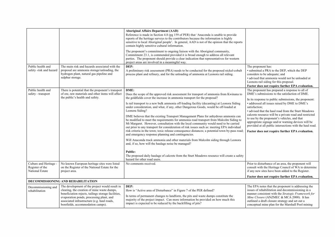
Aboriginal Affairs Department (AAD) Reference is made in Section 4.8 (pg 159 of PER) that �Anaconda is unable to provide reports of the heritage surveys to the contributors because the information is highly sensitive to local Aboriginal people�. In general, AAD is not of the opinion that the reports contain highly sensitive cultural information.
The proponent�s commitment to ongoing liaison with the Aboriginal community, Commitment 23.1, is commended provided it is broad enough to address all relevant parties. The proponent should provide a clear indication that representatives for western project areas are involved in a meaningful way.
Public health and safety -risk and hazard
The main risk and hazards associated with the proposal are ammonia storage/unloading, the hydrogen plant, natural gas pipeline and sulphur storage.
DEP: A preliminary risk assessment (PRA) needs to be conducted for the proposed nickel-cobalt process plant and refinery, and for the unloading of ammonia at Leonora rail siding.
The proponent has: � submitted a PRA to the DEP, which the DEP considers to be adequate; and � advised that ammonia would not be unloaded at Leonora rail siding for this proposal. Factor does not require further EPA evaluation.
Public health and safety - transport
There is potential that the proponent�s transport of ore, raw materials and other items will affect the public�s health and safety.
DME: Does the scope of the approved risk assessment for transport of ammonia from Kwinana to the goldfields cover the increase in ammonia transport for the proposal?
Is rail transport to a new bulk ammonia off-loading facility (decanting) at Leonora Siding under consideration, and what, if any, other Dangerous Goods, would be off-loaded at Leonora Siding?
DME believes that the existing Transport Management Plans for anhydrous ammonia can be modified to meet the requirements for ammonia road transport from Malcolm Siding to Mt Margaret. However, consultation with the local community would need to be carried out prior to any transport for consideration of risk issues such as: meeting EPA individual risk criteria in the town; toxic release consequence distances; a potential town by-pass road; and emergency response planning and contingencies. Will Anaconda truck ammonia and other materials from Malcolm siding through Leonora and, if so, how will the haulage noise be managed? Public: The proposed daily haulage of calcrete from the Sturt Meadows resource will create a safety hazard for other road users.
The proponent has prepared a response to all of DME�s submissions to the satisfaction of DME.
In its response to public submissions, the proponent: � addressed all issues raised by DME to DME�s satisfaction; � advised that the haul road from the Sturt Meadows calcrete resource will be a private road and restricted to use by the proponent�s vehicles, and that appropriate signage and/or warning devices will be provided at all public intersections with the haul road.
Factor does not require further EPA evaluation.
Culture and Heritage - Register of the National Estate
No known European heritage sites were listed on the Register of the National Estate for the project area.
No comments received. Prior to disturbance of an area, the proponent will consult with the Heritage Council of WA to determine if any new sites have been added to the Register.
Factor does not require further EPA evaluation. DECOMMISSIONING AND REHABILITATION
Decommissioning and rehabilitation
The development of the project would result in clearing, the creation of mine waste dumps, beneficiation rejects, tailings storage facilities, evaporation ponds, processing plant, and associated infrastructure (e.g. haul roads, borefields, accommodation camps).
DEP: How is �Active area of Disturbance� in Figure 7 of the PER defined?
In terms of permanent changes to landform, the pits and waste dumps constitute the majority of the project impact. Can more information be provided on how much this impact is expected to be reduced by the backfilling of pits?
The EPA notes that the proponent is addressing the issues of rehabilitation and decommissioning in a manner consistent with the Strategic Framework for Mine Closure (ANZMEC & MCA 2000). It has outlined a draft closure strategy and set out a conceptual mine plan for the Marshall Pool mining
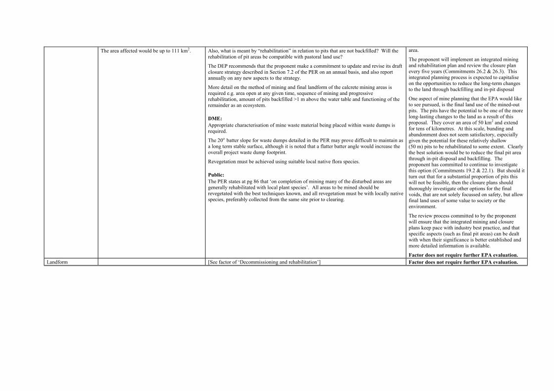
The area affected would be up to 111 km2. Also, what is meant by �rehabilitation� in relation to pits that are not backfilled? Will the rehabilitation of pit areas be compatible with pastoral land use?
The DEP recommends that the proponent make a commitment to update and revise its draft closure strategy described in Section 7.2 of the PER on an annual basis, and also report annually on any new aspects to the strategy.
More detail on the method of mining and final landform of the calcrete mining areas is required e.g. area open at any given time, sequence of mining and progressive rehabilitation, amount of pits backfilled >1 m above the water table and functioning of the remainder as an ecosystem. DME: Appropriate characterisation of mine waste material being placed within waste dumps is required.
The 20o batter slope for waste dumps detailed in the PER may prove difficult to maintain as a long term stable surface, although it is noted that a flatter batter angle would increase the overall project waste dump footprint.
Revegetation must be achieved using suitable local native flora species. Public: The PER states at pg 86 that �on completion of mining many of the disturbed areas are generally rehabilitated with local plant species�. All areas to be mined should be revegetated with the best techniques known, and all revegetation must be with locally native species, preferably collected from the same site prior to clearing.
area.
The proponent will implement an integrated mining and rehabilitation plan and review the closure plan every five years (Commitments 26.2 & 26.3). This integrated planning process is expected to capitalise on the opportunities to reduce the long-term changes to the land through backfilling and in-pit disposal
One aspect of mine planning that the EPA would like to see pursued, is the final land use of the mined-out pits. The pits have the potential to be one of the more long-lasting changes to the land as a result of this proposal. They cover an area of 50 km2 and extend for tens of kilometres. At this scale, bunding and abandonment does not seem satisfactory, especially given the potential for these relatively shallow (50 m) pits to be rehabilitated to some extent. Clearly the best solution would be to reduce the final pit area through in-pit disposal and backfilling. The proponent has committed to continue to investigate this option (Commitments 19.2 & 22.1). But should it turn out that for a substantial proportion of pits this will not be feasible, then the closure plans should thoroughly investigate other options for the final voids, that are not solely focussed on safety, but allow final land uses of some value to society or the environment.
The review process committed to by the proponent will ensure that the integrated mining and closure plans keep pace with industry best practice, and that specific aspects (such as final pit areas) can be dealt with when their significance is better established and more detailed information is available.
Factor does not require further EPA evaluation. Landform [See factor of �Decommissioning and rehabilitation�] Factor does not require further EPA evaluation.
Appendix 4
Recommended Environmental Conditions and
Proponent�s Consolidated Commitments

Statement No.
RECOMMENDED ENVIRONMENTAL CONDITIONS
STATEMENT THAT A PROPOSAL MAY BE IMPLEMENTED (PURSUANT TO THE PROVISIONS OF THE
ENVIRONMENTAL PROTECTION ACT 1986)
Assessment Title: MT MARGARET NICKEL-COBALT PROJECT, SHIRE OF LEONORA
Proposal: The mining and processing of up to 15 million tonnes per annum of
nickel-cobalt ore at the Mt Margaret Project area, approximately 300 kilometres north of Kalgoorlie, as documented in schedule 1 of this statement.
Proponent: Anaconda Nickel Ltd Proponent Address: Level 12, Quay Side, 2 Mill Street Perth WA 6000 Assessment Number: 1317 Report of the Environmental Protection Authority: Bulletin 1025 The proposal referred to above may be implemented subject to the following conditions and procedures: Procedural conditions 1 Implementation and changes 1-1 The proponent shall implement the proposal as documented in schedule 1 of this
statement subject to the conditions of this statement. 1-2 Where the proponent seeks to change any aspect of the proposal as documented in
schedule 1 of this statement in any way that the Minister for the Environment and Heritage determines, on advice of the Environmental Protection Authority, is substantial, the proponent shall refer the matter to the Environmental Protection Authority.
1-3 Where the proponent seeks to change any aspect of the proposal as documented in
schedule 1 of this statement in any way that the Minister for the Environment and Heritage determines, on advice of the Environmental Protection Authority, is not substantial, the proponent may implement those changes upon receipt of written advice from the Minister.
2 Proponent commitments 2-1 The proponent shall implement the environmental management commitments
documented in schedule 2 of this statement. 2-2 The proponent shall implement subsequent environmental management commitments
that the proponent makes as part of the fulfilment of the conditions in this statement. 3 Proponent nomination and contact details 3-1 The proponent for the time being nominated by the Minister for the Environment and
Heritage under section 38(6) or (7) of the Environmental Protection Act 1986 is responsible for the implementation of the proposal until such time as the Minister for the Environment and Heritage has exercised the Minister�s power under section 38(7) of the Act to revoke the nomination of that proponent and nominate another person in respect of the proposal.
3-2 If the proponent wishes to relinquish the nomination, the proponent shall apply for the
transfer of proponent and provide a letter with a copy of this statement endorsed by the proposed replacement proponent that the proposal will be carried out in accordance with this statement and, also, provides contact details and appropriate documentation on the ability of the proposed replacement proponent to carry out the proposal.
3-3 The nominated proponent shall notify the Department of Environment, Water and
Catchment Protection of any change of contact name and address within 60 days of such change.
4 Commencement and time limit of approval 4-1 The proponent shall provide evidence to the Minister for the Environment and Heritage
within five years of the date of this statement that the proposal has been substantially commenced or the approval granted in this statement shall lapse and be void.
Note: The Minister for the Environment and Heritage will determine any dispute as to whether
the proposal has been substantially commenced. 4-2 The proponent shall make application for any extension of approval for the substantial
commencement of the proposal beyond five years from the date of this statement to the Minister for the Environment and Heritage prior to the expiration of the five-year period referred to in condition 4-1.
4-3 The proponent shall demonstrate in the application required by condition 4-2 that:
�� environmental factors of the proposal have not changed significantly, �� new, significant, environmental issues have not arisen, and �� all relevant government authorities have been consulted,

to the requirements of the Minister for the Environment and Heritage, on advice of the Environmental Protection Authority.
Note: The Minister may consider the grant of an extension of the time limit of approval not exceeding five years for the substantial commencement of the proposal.

Environmental conditions 5 Compliance Audit and Performance Review 5-1 The proponent shall prepare an audit program in consultation with and submit
compliance reports to the Department of Environment, Water and Catchment Protection that address:
�� the implementation of the proposal as defined in schedule 1 of this statement; �� evidence of compliance with the conditions and commitments; and �� the performance of the environmental management plans and programs.
Note: Under sections 48(1) and 47(2) of the Environmental Protection Act 1986, the Director
General of the Department of Environment, Water and Catchment Protection is empowered to audit the compliance of the proponent with the statement and should directly receive the compliance documentation related to the conditions, procedures and commitments contained in this statement. Usually, the Department of Environment, Water and Catchment Protection prepares an audit table that can be utilised by the proponent, if required, to prepare an audit program to ensure the proposal is implemented as required. The Director General is responsible for the preparation of written advice to the proponent, which is signed off either by the Minister or, under an endorsed condition clearance process, a delegate within the Environmental Protection Authority or the Department of Environment, Water and Catchment Protection that the requirements have been met.
5-2 The proponent shall submit a performance review report every five years after the start
of the operations/development phase to the Minister for the Environment and Heritage on advice of the Environmental Protection Authority, which addresses:
�� the major environmental issues with the project, the objectives for those issues,
the methodologies used to achieve these, and the key indicators of environmental performance measured against those objectives;
�� the level of progress in the achievement of sound environmental performance, including industry benchmarking and use of best available technology where practicable;
�� significant improvements gained in environmental management, including the use of external peer reviews;
�� stakeholder and community consultation about environmental performance and the outcomes of that consultation, including a report of any on-going concerns being expressed; and
�� the proposed environmental objectives over the next five years, including improvements in technology and management processes.
6 Borefield Contingency Plan 6-1 Prior to commissioning, the proponent shall prepare a Borefield Contingency Plan to the
requirements of the Environmental Protection Authority, on advice of the Water and Rivers Commission and the Department of Environmental Protection, for the
development of contingency water supplies in the event that the proposed production borefield is unable to sustain the water requirements of the proposal.
This Plan shall include a detailed timetable of actions to develop the contingency water supply into a production borefield within one year.
6-2 In the event that monitoring identifies unacceptable impacts, the Environmental
Protection Authority, on advice of the Water and Rivers Commission, the Department of Conservation and Land Management, and the Department of Environmental Protection, may require the proponent to implement actions set out in the Borefield Contingency Plan.
6-3 The proponent shall review and where necessary revise the Borefield Contingency Plan
required by condition 6-1 annually, or as required by the Department of Environmental Protection on advice of the Water and Rivers Commission.
7 Greenhouse Gas Emissions Management Plan 7-1 Prior to construction of the Processing Plant, the proponent shall prepare a Greenhouse
Gas Emissions Management Plan:
� to ensure that �greenhouse gas� emissions from the project are adequately addressed and best available efficient technologies are used to minimise total net �greenhouse gas� emissions and/or �greenhouse gas� emissions per unit of product; and
� to mitigate �greenhouse gas� emissions in accordance with the Framework
Convention on Climate Change 1992, and consistent with the National Greenhouse Strategy;
to the requirements of the Environmental Protection Authority on advice of the Department of Environmental Protection.
This Plan shall include:
1 calculation of the �greenhouse gas� emissions associated with the proposal, as indicated in �Minimising Greenhouse Gas Emissions, Guidance for the Assessment of Environmental Factors, No. 12� published by the Environmental Protection Authority;
2 specific measures to minimise the total net �greenhouse gas� emissions and/or the
�greenhouse gas� emissions per unit of product associated with the proposal; 3 ongoing review and reporting of �greenhouse gas� emissions; 4 estimation of the �greenhouse gas� efficiency of the project (per unit of product
and/or other agreed performance indicators) and comparison with the efficiencies of other comparable projects producing a similar product;
5 an analysis of the extent to which the proposal meets the requirements of the
National Greenhouse Strategy using a combination of:

� �no regrets� measures; � �beyond no regrets� measures; � land use change or forestry offsets; � international flexibility mechanisms; and
6 a target set by the proponent for the reduction of total net �greenhouse gas�
emissions and/or �greenhouse gas� emissions per unit of product over time, and annual reporting of progress made in achieving this target.
Note - In Section 5 above, the following definitions apply: (1) �no regrets� measures are those that can be implemented by a proponent which are
effectively cost-neutral and provide the proponent with returns in savings which offset the initial capital expenditure that may be incurred.
(2) �beyond no regrets� measures are those that can be implemented by a proponent
which involve some additional cost that is not expected to be recovered. 7-2 The proponent shall implement the Greenhouse Gas Emissions Management Plan
required by condition 7-1. 7-3 The proponent shall make the Greenhouse Gas Emissions Management Plan required by
condition 7-1 publicly available, to the requirements of the Environmental Protection Authority.
8 Subterranean Fauna Sampling Plan 8-1 Prior to commencing production from each borefield or calcrete mining operation, the
proponent shall develop a Subterranean Fauna Sampling Plan for the respective borefield or calcrete mining area to the requirements of the Environmental Protection Authority on advice of the Department of Environmental Protection, the Department of Conservation and Land Management, and the Western Australian Museum.
The objective of this Plan is:
� to increase scientific knowledge about subterranean fauna to assist in the conservation of this element of the environment.
This Plan shall address:
1 subterranean fauna surveys of the area to be affected by the borefield or calcrete mining operation to assist in establishing the conservation significance of any species within the affected areas;
2 characterisation of subterranean fauna habitats to be affected by the borefield or
calcrete mining operation and identification of similar subterranean fauna habitats outside the affected areas;

3 subterranean fauna surveys of similar habitats outside the areas to be affected by the borefield or calcrete mining operation to assist in establishing the conservation significance of fauna within the areas to be affected; and
4 specific measures to record and preserve biological information on any species
collected in the project area. 8-2 The proponent shall implement the Subterranean Fauna Sampling Plan required by
condition 8-1. 8-3 The proponent shall make the Subterranean Fauna Sampling Plan required by
condition 8-1 publicly available, to the requirements of the Environmental Protection Authority.
8-4 The proponent shall submit the results of the Subterranean Fauna Sampling Plan to the
Environmental Protection Authority, the Department of Conservation and Land Management, and the Western Australian Museum.
8-5 In the event that the Environmental Protection Authority considers, based on the results
of the Subterranean Fauna Sampling Plan, that its objective for this Plan would be compromised, then the proponent shall develop an action plan to the requirements and timing of the Environmental Protection Authority.
9 Significant Flora Management Plan 9-1 Prior to ground-disturbing activities, the proponent shall prepare a Significant Flora
Management Plan to the requirements of the Environmental Protection Authority on advice of the Department of Environmental Protection and the Department of Conservation and Land Management.
This Plan shall address:
1. the impacts to significant flora species within the project area; 2. where necessary, offsite surveys to better understand the regional significance of
significant flora species; 3. planning to avoid any disturbance to significant flora wherever possible; and 4. the propagation and return of significant flora into rehabilitation areas. Note: �Significant flora� are those that are Declared Rare, Priority, restricted,
undescribed or range extensions of species in the project area. 9-2 The proponent shall implement the Significant Flora Management Plan required by
condition 9-1 to the requirements of the Environmental Protection Authority on the advice of CALM and the DEP.
9-3 The proponent shall review the Significant Flora Management Plan at least every three years to the requirements of the Environmental Protection Authority on the advice of CALM and the DEP.
Note 1 The proponent is required to apply for a Works Approval and Licence for this project
under the provisions of Part V of the Environmental Protection Act 1986.
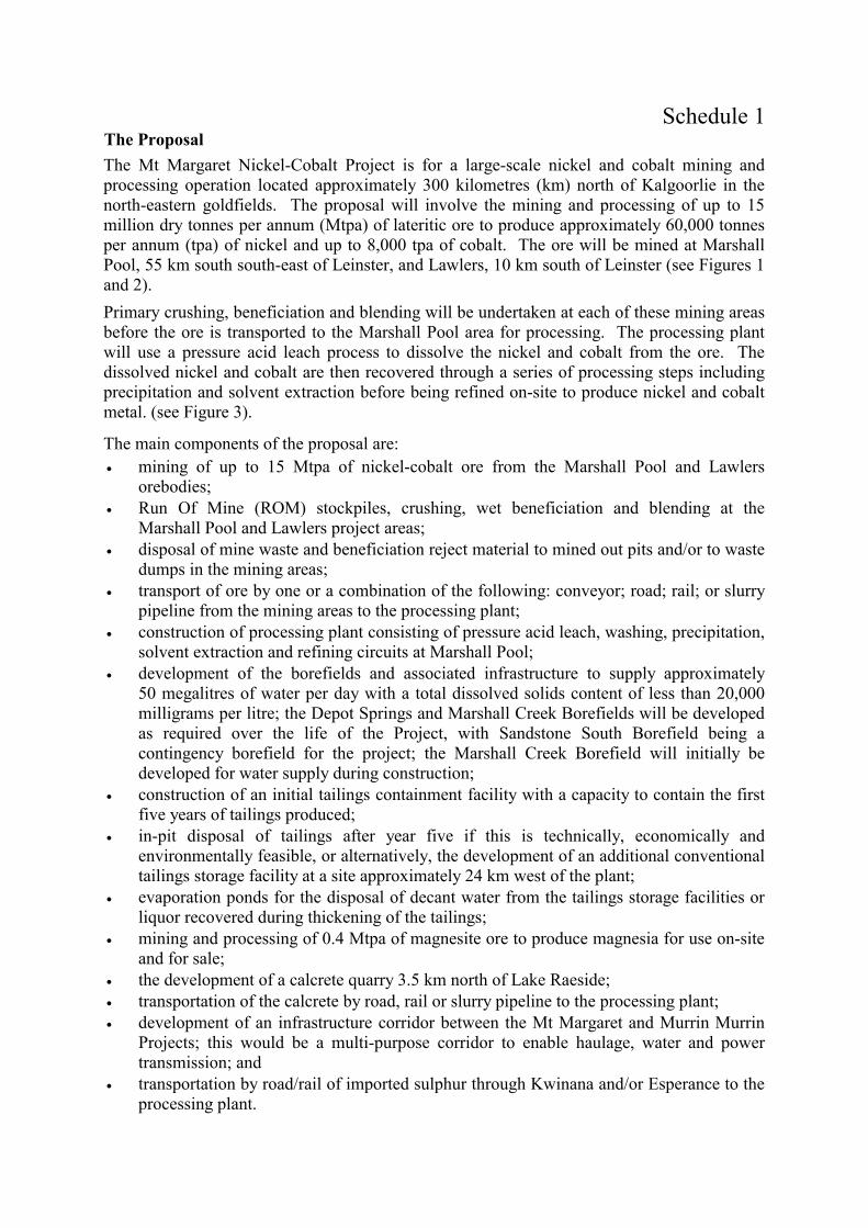
Schedule 1 The Proposal The Mt Margaret Nickel-Cobalt Project is for a large-scale nickel and cobalt mining and processing operation located approximately 300 kilometres (km) north of Kalgoorlie in the north-eastern goldfields. The proposal will involve the mining and processing of up to 15 million dry tonnes per annum (Mtpa) of lateritic ore to produce approximately 60,000 tonnes per annum (tpa) of nickel and up to 8,000 tpa of cobalt. The ore will be mined at Marshall Pool, 55 km south south-east of Leinster, and Lawlers, 10 km south of Leinster (see Figures 1 and 2). Primary crushing, beneficiation and blending will be undertaken at each of these mining areas before the ore is transported to the Marshall Pool area for processing. The processing plant will use a pressure acid leach process to dissolve the nickel and cobalt from the ore. The dissolved nickel and cobalt are then recovered through a series of processing steps including precipitation and solvent extraction before being refined on-site to produce nickel and cobalt metal. (see Figure 3).
The main components of the proposal are: �� mining of up to 15 Mtpa of nickel-cobalt ore from the Marshall Pool and Lawlers
orebodies; �� Run Of Mine (ROM) stockpiles, crushing, wet beneficiation and blending at the
Marshall Pool and Lawlers project areas; �� disposal of mine waste and beneficiation reject material to mined out pits and/or to waste
dumps in the mining areas; �� transport of ore by one or a combination of the following: conveyor; road; rail; or slurry
pipeline from the mining areas to the processing plant; �� construction of processing plant consisting of pressure acid leach, washing, precipitation,
solvent extraction and refining circuits at Marshall Pool; �� development of the borefields and associated infrastructure to supply approximately
50 megalitres of water per day with a total dissolved solids content of less than 20,000 milligrams per litre; the Depot Springs and Marshall Creek Borefields will be developed as required over the life of the Project, with Sandstone South Borefield being a contingency borefield for the project; the Marshall Creek Borefield will initially be developed for water supply during construction;
�� construction of an initial tailings containment facility with a capacity to contain the first five years of tailings produced;
�� in-pit disposal of tailings after year five if this is technically, economically and environmentally feasible, or alternatively, the development of an additional conventional tailings storage facility at a site approximately 24 km west of the plant;
�� evaporation ponds for the disposal of decant water from the tailings storage facilities or liquor recovered during thickening of the tailings;
�� mining and processing of 0.4 Mtpa of magnesite ore to produce magnesia for use on-site and for sale;
�� the development of a calcrete quarry 3.5 km north of Lake Raeside; �� transportation of the calcrete by road, rail or slurry pipeline to the processing plant; �� development of an infrastructure corridor between the Mt Margaret and Murrin Murrin
Projects; this would be a multi-purpose corridor to enable haulage, water and power transmission; and
�� transportation by road/rail of imported sulphur through Kwinana and/or Esperance to the processing plant.

The key characteristics of the proposal are summarised in the below table.
Key Proposal Characteristics Table Element Description
Life of Project (Indicative) 30 years Development Stages Stage 1 Mining and beneficiation of up to 15 (Mtpa of ore to produce 6 Mtpa
of leach feed to a pressure acid leach circuit which will be processed to 60,000 tpa of contained nickel as nickel-cobalt hydroxide.
Stage 2 Refinery to produce up to 160,000 tpa of nickel metal and 16,000 tpa of cobalt metal from nickel-cobalt hydroxide. The refinery will produce up to 100,000 tpa of nickel metal from nickel-cobalt hydroxides supplied by external projects. The commencement of construction of this Project stage is currently scheduled for 2003.
Primary Inputs Nickel/Cobalt Ore (Mtpa) up to 15 Magnesite Ore (Mtpa) 0.4 Calcrete (Mtpa) 1.25 Elemental Sulphur (Mtpa) 0.9 Process Water (megalitres/ per day with TDS of <20,000 milligrams per litre)
50
Natural Gas (terajoules per day) 40 Nickel/Cobalt Hydroxide (tpa Ni) 100,000 Outputs Nickel metal (tpa) up to 160,000 Cobalt metal (tpa) 16,000 Magnesia (tpa) 200,000 Wastes and Emissions Coarse rejects from beneficiation (Mtpa) 5 Tailings Solids (Mtpa) 8 Water from Dewatering Operations (ML/d) up to 1 Sulphur Dioxide (grams per second) 186 (approximately) Oxides of Nitrogen (grams per second as nitrogen dioxide) 24 (approximately) Greenhouse Gas (carbon dioxide equivalent Mtpa) 1.5 (approximately) Waste Dumps and Ore Stockpiles � Indicative Characteristics Without In-Pit Disposal With In-Pit Disposal Area disturbed by waste dumps (km2)* Ore stockpiles (km2) Coarse rejects (from beneficiation) (km2)
13 8 9
12 10 4
TOTAL (km2) 30 26 Final height of waste dumps above ground level (m) 30 Pits - Indicative Characteristics Area to be disturbed (km2) Depth of pits
50 maximum depth of 50 metres below ground level
Tailing Storage Facility and Evaporation Ponds � Indicative Characteristics Assuming Conventional Subaerial Storage
Without In-Pit Disposal
With In-Pit Disposal
Area to be disturbed for tailing storage facility (km2) 9 3 Area to be disturbed for evaporation ponds (km2) 6 6 TOTAL (km2) 15 9 Other areas of disturbance � Indicative Characteristics Calcrete Quarry (km2) Magnesite Mine (associated with the Ni/Co orebodies) (km2) Infrastructure (inc. corridors and accommodation villages) (km2)
3 1 12
Total Area of disturbance (assuming no in-pit disposal) (km2) 111 *Note: 1 km2 = 100 hectares ML/d � million litres per day TDS � Total Dissolved Solids tpa � tonnes per annum Mtpa � million tonnes per annum
Figures 1. Location Plan 2. Project Layout 3. Process Flow Chart

Schedule 2
Proponent's Consolidated Environmental Management Commitments
July 2001
MT MARGARET NICKEL COBALT PROJECT (ASSESSMENT NO. 1317)
ANACONDA NICKEL LTD

Proponent�s Commitments � Mt Margaret Nickel-Cobalt Project (Assess. No. 1317)
Abbreviations: AAD: Aboriginal Affairs Department EA: Environment Australia ACMC: Aboriginal Cultural Materials Committee EMP: Environmental Management Plan AER: Annual Environmental Report EMS: Environmental Management System CALM: Department of Conservation and Land Management EPA: Environmental Protection Authority DEP: Department of Environmental Protection DME: Department of Minerals and Energy
NPI: National Pollution Inventory WAM: WA Museum
WRC: Water and Rivers Commission
Issues Objectives Commitments (Action) Timing Whose Advice Evidence of Compliance
Environmental Management Programme (EMP)
To implement the EMP to ensure sound environmental management of the Project's construction phase.
Commitment 1.1 Implement the EMP for the Project�s construction phase. (Draft EMP, Apprendix C, PER) Commitment 1.2 Ensure that contractors comply with the environmental management strategies and procedures described in the EMP by making them aware of the requirements of the EMP through the induction programmes and undertaking routine audits of their activities during construction.
1.1 Prior to commencement of the Project. 1.2 During the construction of the Project.
To the requirements of the EPA on the advice of EA, DME, CALM, and other relevant agencies.
The EMP implementation and results of audits will be reported in the Annual Environmental Report (AER).
Environmental Management System (EMS)
To develop and implement an EMS to ensure sound environmental management of the Project's operation and decommissioning phases.
Commitment 2.1 Develop and implement an EMS for the operation of the Project. Commitment 2.2 Ensure that its contractors comply with the environmental management strategies and procedures described in the EMS through induction programmes and by undertaking routine audits of their activities.
2.1 Prior to start of operation of the Project. 2.2 Biannual audits during the operation of the Project.
To the requirements of the EPA on the advice of DME and CALM.
The EMS is approved by the DEP. Implementation and results of audits will be reported in the AER.
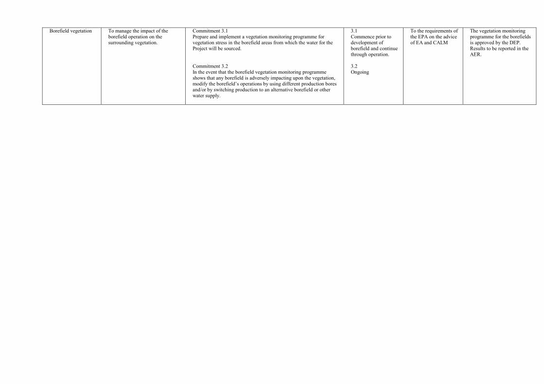
Borefield vegetation To manage the impact of the borefield operation on the surrounding vegetation.
Commitment 3.1 Prepare and implement a vegetation monitoring programme for vegetation stress in the borefield areas from which the water for the Project will be sourced. Commitment 3.2 In the event that the borefield vegetation monitoring programme shows that any borefield is adversely impacting upon the vegetation, modify the borefield�s operations by using different production bores and/or by switching production to an alternative borefield or other water supply.
3.1 Commence prior to development of borefield and continue through operation. 3.2 Ongoing
To the requirements of the EPA on the advice of EA and CALM
The vegetation monitoring programme for the borefields is approved by the DEP. Results to be reported in the AER.
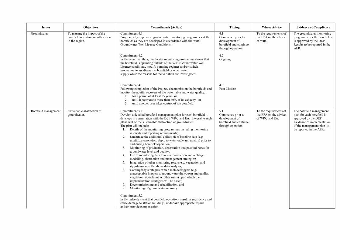
Issues Objectives Commitments (Action) Timing Whose Advice Evidence of Compliance
Groundwater To manage the impact of the borefield operation on other users in the region.
Commitment 4.1 Progressively implement groundwater monitoring programmes at the borefields as they are developed in accordance with the WRC Groundwater Well Licence Conditions. Commitment 4.2 In the event that the groundwater monitoring programme shows that the borefield is operating outside of the WRC Groundwater Well Licence conditions, modify pumping regimes and/or switch production to an alternative borefield or other water supply while the reasons for the variation are investigated. Commitment 4.3 Following completion of the Project, decommission the borefields and monitor the aquifer recovery of the water table and water quality:
1. for a period of at least 25 years; or 2. until it recovers to more than 60% of its capacity ; or 3. until another user takes control of the borefield.
4.1 Commence prior to development of borefield and continue through operation. 4.2 Ongoing 4.3 Post Closure
To the requirements of the EPA on the advice of WRC.
The groundwater monitoring programme for the borefields is approved by the DEP. Results to be reported in the AER.
Borefield management Sustainable abstraction of groundwater.
Commitment 5.1 Develop a detailed borefield management plan for each borefield it develops in consultation with the DEP WRC and EA. Integral to such plans will be the sustainable abstraction of groundwater. The plan will include:
1. Details of the monitoring programmes including monitoring intervals and reporting requirements;
2. Undertake the additional collection of baseline data (e.g. rainfall, evaporation, depth to water table and quality) prior to and during borefield operation;
3. Monitoring of production, observation and pastoral bores for groundwater level and quality;
4. Use of monitoring data to revise production and recharge modelling, abstraction and management strategies;
5. Integration of other monitoring results e.g. vegetation and stygofauna into the above data analysis;
6. Contingency strategies, which include triggers (e.g. unacceptable impacts to groundwater drawdown and quality, vegetation, stygofauna or other users) upon which the implementation strategies will be based;
7. Decommissioning and rehabilitation; and 8. Monitoring of groundwater recovery.
Commitment 5.2 In the unlikely event that borefield operations result in subsidence and cause damage to station buildings, undertake appropriate repairs and/or provide compensation.
5.1 Commence prior to development of borefield and continue through operation.
To the requirements of the EPA on the advice of WRC and EA.
The borefield management plan for each borefield is approved by the DEP. Evidence of implementation of the management plan to be reported in the AER.

Issues Objectives Commitments (Action) Timing Whose Advice Evidence of Compliance
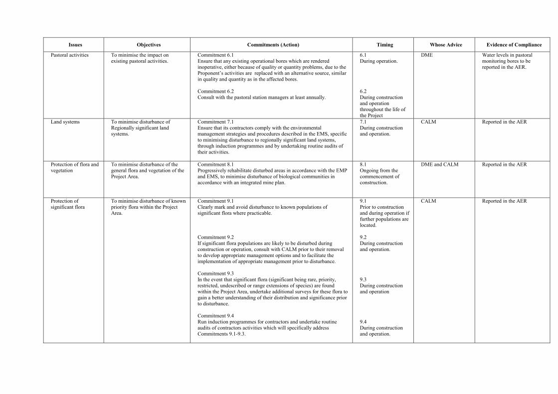
Issues Objectives Commitments (Action) Timing Whose Advice Evidence of Compliance
Pastoral activities To minimise the impact on existing pastoral activities.
Commitment 6.1 Ensure that any existing operational bores which are rendered inoperative, either because of quality or quantity problems, due to the Proponent�s activities are replaced with an alternative source, similar in quality and quantity as in the affected bores. Commitment 6.2 Consult with the pastoral station managers at least annually.
6.1 During operation. 6.2 During construction and operation throughout the life of the Project
DME Water levels in pastoral monitoring bores to be reported in the AER.
Land systems To minimise disturbance of Regionally significant land systems.
Commitment 7.1 Ensure that its contractors comply with the environmental management strategies and procedures described in the EMS, specific to minimising disturbance to regionally significant land systems, through induction programmes and by undertaking routine audits of their activities.
7.1 During construction and operation.
CALM Reported in the AER
Protection of flora and vegetation
To minimise disturbance of the general flora and vegetation of the Project Area.
Commitment 8.1 Progressively rehabilitate disturbed areas in accordance with the EMP and EMS, to minimise disturbance of biological communities in accordance with an integrated mine plan.
8.1 Ongoing from the commencement of construction.
DME and CALM Reported in the AER
Protection of significant flora
To minimise disturbance of known priority flora within the Project Area.
Commitment 9.1 Clearly mark and avoid disturbance to known populations of significant flora where practicable. Commitment 9.2 If significant flora populations are likely to be disturbed during construction or operation, consult with CALM prior to their removal to develop appropriate management options and to facilitate the implementation of appropriate management prior to disturbance. Commitment 9.3 In the event that significant flora (significant being rare, priority, restricted, undescribed or range extensions of species) are found within the Project Area, undertake additional surveys for these flora to gain a better understanding of their distribution and significance prior to disturbance. Commitment 9.4 Run induction programmes for contractors and undertake routine audits of contractors activities which will specifically address Commitments 9.1-9.3.
9.1 Prior to construction and during operation if further populations are located. 9.2 During construction and operation.
9.3 During construction and operation 9.4 During construction and operation.
CALM Reported in the AER
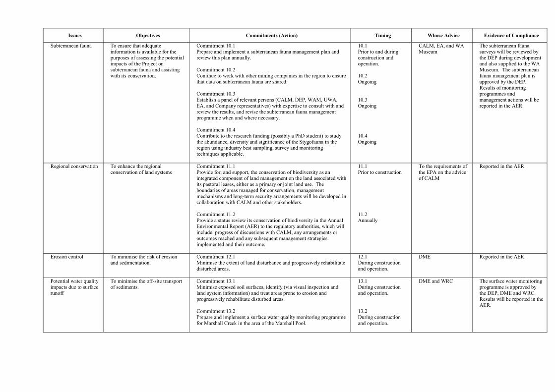
Issues Objectives Commitments (Action) Timing Whose Advice Evidence of Compliance
Subterranean fauna To ensure that adequate information is available for the purposes of assessing the potential impacts of the Project on subterranean fauna and assisting with its conservation.
Commitment 10.1 Prepare and implement a subterranean fauna management plan and review this plan annually. Commitment 10.2 Continue to work with other mining companies in the region to ensure that data on subterranean fauna are shared. Commitment 10.3 Establish a panel of relevant persons (CALM, DEP, WAM, UWA, EA, and Company representatives) with expertise to consult with and review the results, and revise the subterranean fauna management programme when and where necessary. Commitment 10.4 Contribute to the research funding (possibly a PhD student) to study the abundance, diversity and significance of the Stygofauna in the region using industry best sampling, survey and monitoring techniques applicable.
10.1 Prior to and during construction and operation. 10.2 Ongoing 10.3 Ongoing 10.4 Ongoing
CALM, EA, and WA Museum
The subterranean fauna surveys will be reviewed by the DEP during development and also supplied to the WA Museum. The subterranean fauna management plan is approved by the DEP. Results of monitoring programmes and management actions will be reported in the AER.
Regional conservation To enhance the regional conservation of land systems
Commitment 11.1 Provide for, and support, the conservation of biodiversity as an integrated component of land management on the land associated with its pastoral leases, either as a primary or joint land use. The boundaries of areas managed for conservation, management mechanisms and long-term security arrangements will be developed in collaboration with CALM and other stakeholders. Commitment 11.2 Provide a status review its conservation of biodiversity in the Annual Environmental Report (AER) to the regulatory authorities, which will include: progress of discussions with CALM, any arrangements or outcomes reached and any subsequent management strategies implemented and their outcome.
11.1 Prior to construction 11.2 Annually
To the requirements of the EPA on the advice of CALM
Reported in the AER
Erosion control To minimise the risk of erosion and sedimentation.
Commitment 12.1 Minimise the extent of land disturbance and progressively rehabilitate disturbed areas.
12.1 During construction and operation.
DME Reported in the AER
Potential water quality impacts due to surface runoff
To minimise the off-site transport of sediments.
Commitment 13.1 Minimise exposed soil surfaces, identify (via visual inspection and land system information) and treat areas prone to erosion and progressively rehabilitate disturbed areas. Commitment 13.2 Prepare and implement a surface water quality monitoring programme for Marshall Creek in the area of the Marshall Pool.
13.1 During construction and operation. 13.2 During construction and operation.
DME and WRC The surface water monitoring programme is approved by the DEP, DME and WRC. Results will be reported in the AER.

Issues Objectives Commitments (Action) Timing Whose Advice Evidence of Compliance
Dust control � construction phase
To control any dust generated as a result of construction phase activities.
Commitment 14.1 Implement dust control measures including: �� minimising soil disturbance; and �� use of dust-suppression measures (e.g. water sprays)
14.1 During construction.
DME No complaints received. If complaints are received, these, and the remediation measures implemented will be reported in the AER.
Dust control � operations phase
To control dust generation during the operations phase.
Commitment 15.1 Implement dust control measures including: �� regular cleaning of areas likely to accumulate dust; �� sealing of major roadways within the Plant Site; and �� use of water sprays on mine areas, ore and calcrete haulage
routes, stockpiles and other Project Areas, as required.
15.1 During operation.
DME No complaints received. If complaints are received, these, and the remediation measures implemented will be reported in the AER.
Greenhouse gas emissions
To reduce greenhouse gas emissions and to comply with the State and Federal Government Greenhouse Policies.
Commitment 16.1 The total greenhouse gas emissions (carbon dioxide, methane, nitrous oxide, perfluorocarbons, hydrofluorocarbons and sulphur hexafluoride) for the project will be calculated by the proponent on an annual basis and reported to the DEP. Commitment 16.2 Continue to explore mechanisms to reduce greenhouse gas emissions. Commitment 16.3 Enter into the Commonwealth�s Greenhouse Challenge Programme once commissioning has been completed and steady-state operations have been achieved.
16.1 During operation
16.2 During operation 16.3 During operations
Australian Greenhouse Office
Reported in the AER. NPI reporting.
Noise To meet the State�s noise regulations during construction and operation of the Project.
Commitment 17.1 If noise levels attributable to the Project appear likely to exceed the noise regulations, implement noise reduction measurements such as the use of waste dumps as noise barriers. Commitment 17.3 The Proponent will not mine within 2 km of the Agnew Hotel until the noise and dust emissions can be fully assessed. Commitment 17.2 The Proponent will not undertake mining or blasting in the areas within close proximity to the Agnew Hotel during night time hours without prior approval.
17.1 During construction and operation 17.2 During construction and operation 17.3 During construction and operation
DME No complaints received. If complaints are received, these, and the remediation measures implemented will be reported in the AER.

Issues Objectives Commitments (Action) Timing Whose Advice Evidence of Compliance
Tailings storage facilities and evaporation ponds
To select the most appropriate method, considering environmental, technical and economic factors, to dispose of tailings and liquor after the first five years of operation. To move towards the disposal of thickened tailings which contain no free draining liquid upon placement.
Commitment 18.1 Undertake the following: �� A detailed assessment of tailings solids and water liquor
geochemistry, including predicted compositions relevant to environmental guidelines and standards. This assessment will focus on Total Dissolved Solids, major ions and metals (via an elemental analysis).
�� A detailed assessment of the tailings stream to investigate the technical and economic issues associated with the thickening and subsequent transport and handling of the thickened tailings stream.
�� An assessment of the predicted particle form and geotechnical characteristics of the tailings, including settling characteristics, and settled and compacted permeabilities.
�� A detailed evaluation of the potential sites for the tailings storage facilities, including those for in-pit disposal at Marshall Pool and conventional sub-aerial deposition.
�� Submit a Notice of Intent and Works Approval Application to the DEP and DME, which presents the results of the above studies and provides detailed information relating to the design, construction and operation of the proposed tailings storage facility and evaporation ponds.
Commitment 18.2 Backfill the mined-out pits with thickened tailings material if the above studies indicate that this is geotechnically, environmentally and economically feasible.
18.1 Years 1 to 5 of operation.
DEP (Pollution Prevention Division), DME and WRC
Notice of Intent and Works Approval Application. The Notice of Intent would address issues associated with seepage management, groundwater contamination modelling and management, environmental impacts and management, and closure and rehabilitation.
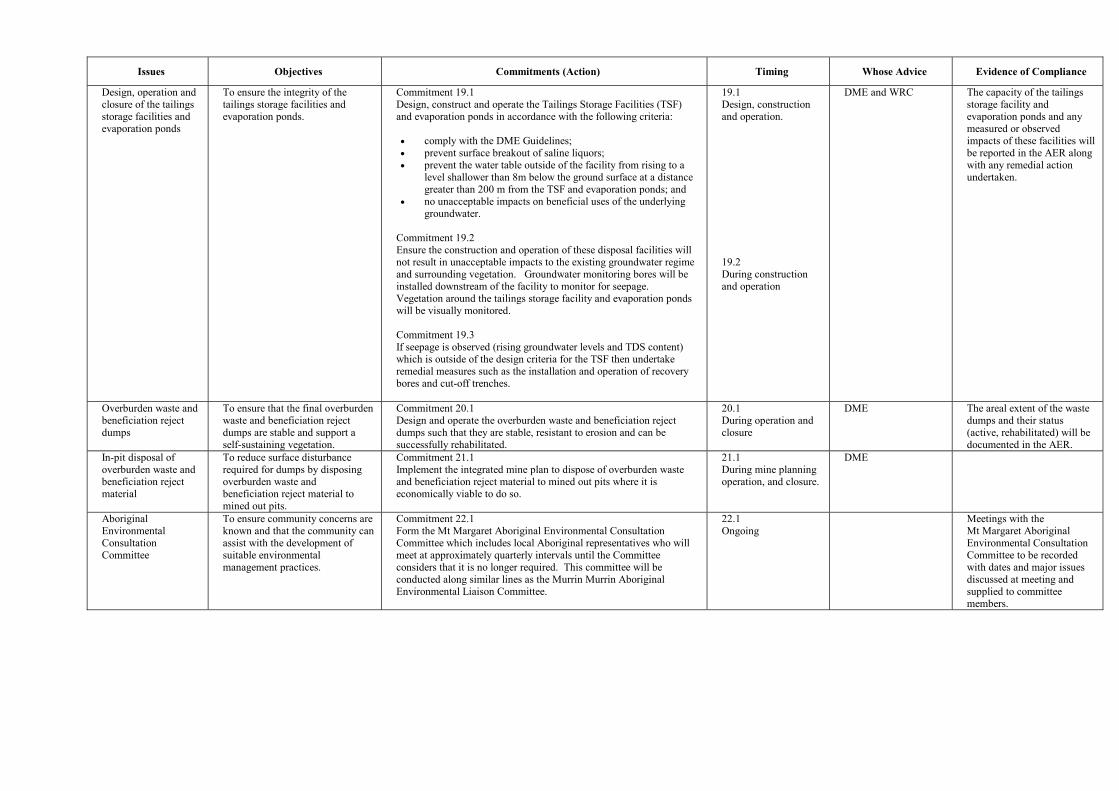
Issues Objectives Commitments (Action) Timing Whose Advice Evidence of Compliance
Design, operation and closure of the tailings storage facilities and evaporation ponds
To ensure the integrity of the tailings storage facilities and evaporation ponds.
Commitment 19.1 Design, construct and operate the Tailings Storage Facilities (TSF) and evaporation ponds in accordance with the following criteria: �� comply with the DME Guidelines; �� prevent surface breakout of saline liquors; �� prevent the water table outside of the facility from rising to a
level shallower than 8m below the ground surface at a distance greater than 200 m from the TSF and evaporation ponds; and
�� no unacceptable impacts on beneficial uses of the underlying groundwater.
Commitment 19.2 Ensure the construction and operation of these disposal facilities will not result in unacceptable impacts to the existing groundwater regime and surrounding vegetation. Groundwater monitoring bores will be installed downstream of the facility to monitor for seepage. Vegetation around the tailings storage facility and evaporation ponds will be visually monitored. Commitment 19.3 If seepage is observed (rising groundwater levels and TDS content) which is outside of the design criteria for the TSF then undertake remedial measures such as the installation and operation of recovery bores and cut-off trenches.
19.1 Design, construction and operation.
19.2 During construction and operation
DME and WRC The capacity of the tailings storage facility and evaporation ponds and any measured or observed impacts of these facilities will be reported in the AER along with any remedial action undertaken.
Overburden waste and beneficiation reject dumps
To ensure that the final overburden waste and beneficiation reject dumps are stable and support a self-sustaining vegetation.
Commitment 20.1 Design and operate the overburden waste and beneficiation reject dumps such that they are stable, resistant to erosion and can be successfully rehabilitated.
20.1 During operation and closure
DME The areal extent of the waste dumps and their status (active, rehabilitated) will be documented in the AER.
In-pit disposal of overburden waste and beneficiation reject material
To reduce surface disturbance required for dumps by disposing overburden waste and beneficiation reject material to mined out pits.
Commitment 21.1 Implement the integrated mine plan to dispose of overburden waste and beneficiation reject material to mined out pits where it is economically viable to do so.
21.1 During mine planning operation, and closure.
DME
Aboriginal Environmental Consultation Committee
To ensure community concerns are known and that the community can assist with the development of suitable environmental management practices.
Commitment 22.1 Form the Mt Margaret Aboriginal Environmental Consultation Committee which includes local Aboriginal representatives who will meet at approximately quarterly intervals until the Committee considers that it is no longer required. This committee will be conducted along similar lines as the Murrin Murrin Aboriginal Environmental Liaison Committee.
22.1 Ongoing
Meetings with the Mt Margaret Aboriginal Environmental Consultation Committee to be recorded with dates and major issues discussed at meeting and supplied to committee members.
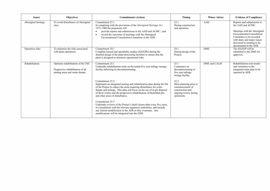
Issues Objectives Commitments (Action) Timing Whose Advice Evidence of Compliance
Aboriginal heritage To avoid disturbance of Aboriginal sites.
Commitment 23.1 In complying with the provisions of the Aboriginal Heritage Act 1972-1980 the proponent will: �� provide reports and submissions to the AAD and ACMC.; and �� record the outcomes of meetings with the Aboriginal
Environmental Consultation Committee in the AER.
23.1 During construction and operation.
AAD Reports and submissions to the AAD and ACMC. Meetings with the Aboriginal Environmental Consultation Committee to be recorded with dates and major issues discussed at meeting to be documented in the AER.
Operation risks To minimise the risks associated with plant operations.
Commitment 24.1 Complete hazard and operability studies (HAZOPs) during the detailed design of the plant processing facilities to ensure that the plant is designed to minimise operational risks.
24.1 During design of the Project.
DME The HAZOP will be submitted to the DME for approval.
Rehabilitation Optimise rehabilitation of the TSF. Progressive rehabilitation of all mining areas and waste dumps.
Commitment 25.1 Undertake rehabilitation trials on the initial five year tailings storage facility following its decommissioning. Commitment 25.2 Implement an integrated mining and rehabilitation plan during the life of the Project to reduce the areas requiring disturbance for waste dumps and tailings. This plan will focus on the use of in-pit disposal of these wastes and the progressive rehabilitation of backfilled pits and other areas of disturbance. Commitment 25.3 Undertake reviews of the Project�s draft closure plan every five years, in consultation with the relevant regulatory authorities, and include any interim modification in the AER as they eventuate. Any modifications will be integrated into the EMS.
25.1 Commence on decommissioning of five year tailings storage facility. 25.2 Mine planning prior to commencement of construction and ongoing review during operations.
DME and CALM Rehabilitation trial results and variations to the integrated mine plan to be reported in AER.

Appendix 5
Summary of Submissions and
Proponent�s Response to Submissions