Mt Arapiles-Tooan State Park - Parks Victoria
2
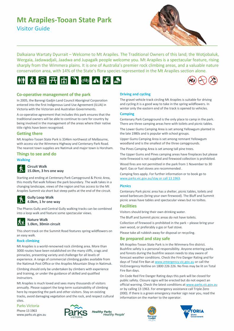
Parks Victoria Phone 13 1963 www.parks.vic.gov.au Co-operative management of the park In 2005, the Barengi Gadjin Land Council Aboriginal Corporation entered into the first Indigenous Land Use Agreement (ILUA) in Victoria with the Victorian and Australian Governments. A co-operative agreement that includes this park ensures that the traditional owners will be able to continue to care for country by being involved in the management of the areas where their native title rights have been recognised. Getting there Mt Arapiles-Tooan State Park is 334km northwest of Melbourne, with access via the Wimmera Highway and Centenary Park Road. The nearest town supplies are Natimuk and major town is Horsham. Things to see and do Walking Circuit Walk 15.0km, 3 hrs one way Starting and ending at Centenary Park Campground & Picnic Area, this mostly flat walk follows the park boundary. The walk takes in a changing landscape, views of the region and has access to the Mt Arapiles Summit via short but steep paths at the end of the circuit. Gully Loop Walk 4.0km, 1 hr one way The Pharos Gully and Central Gully walking tracks can be combined into a loop walk and feature some spectacular views. Nature Walk 1.0km, 30min circuit This short track on the Summit Road features spring wildflowers on an easy walk. Rock climbing Mt Arapiles is a world-renowned rock climbing area. More than 3000 routes have been established on the many cliffs, crags and pinnacles, presenting variety and challenge for all levels of experience. A range of commercial climbing guides available from the Natimuk Post Office or the Arapiles Mountain Shop in Natimuk. Climbing should only be undertaken by climbers with experience and training, or under the guidance of skilled and qualified instructors. Mt Arapiles is much loved and sees many thousands of visitors annually. Please support the long-term sustainability of climbing here by respecting the park and other visitors. Stay on existing tracks, avoid damaging vegetation and the rock, and respect cultural sites. Driving and cycling The gravel vehicle track circling Mt Arapiles is suitable for driving and cycling.It is a good way to take in the spring wildflowers. In winter only the eastern end of the track is opened to vehicles. Camping Centenary Park Campground is the only place to camp in the park. There are three camping areas here with toilets and picnic tables. The Lower Gums Camping Area is set among Yellowgum planted in the late 1980s and is popular with school groups. Upper Gums Camping Area is set among remnant Yellowgum woodland and is the smallest of the three campgrounds. The Pines Camping Area is set among tall pine trees. The Upper Gums and Pines camping areas have fireplaces but please note firewood is not supplied and firewood collection is prohibited. Wood fires are not permitted in the park from 1 November to 30 April. Gas or fuel stoves are recommended . Camping fees apply. For further information or to book go to www.parks.vic.gov.au/stay or call 13 1963. Picnics Centenary Park picnic area has a shelter, picnic tables, toilets and wood barbecues (bring your own firewood). The Bluff and Summit picnic areas have tables and spectacular views but no toiltes. Facilities Visitors should bring their own drinking water. The Bluff and Summit picnic areas do not have toilets. Collection of firewood is prohibited in the park – please bring your own wood, or preferably a gas or fuel stove. Please take all rubbish away for disposal or recycling. Be prepared and stay safe Mt Arapiles-Tooan State Park is in the Wimmera fire district. Bushfire safety is a personal responsibility. Anyone entering parks and forests during the bushfire season needs to stay aware of forecast weather conditions. Check the Fire Danger Rating and for days of Total Fire Ban at www.emergency.vic.gov.au or call the VicEmergency Hotline on 1800 226 226. No fires may be lit on Total Fire Ban days. On Code Red Fire Danger Rating days this park will be closed for public safety. Closure signs will be erected but do not expect an official warning. Check the latest conditions at www.parks.vic.gov.au or by calling 13 1963. For emergency assistance call Triple Zero (000). If there is a green emergency marker sign near you, read the information on the marker to the operator. Mt Arapiles-Tooan State Park Visitor Guide Dalkaiana Wartaty Dyurrait – Welcome to Mt Arapiles. The Traditional Owners of this land; the Wotjobaluk, Wergaia, Jadawadjali, Jaadwa and Jupagalk people welcome you. Mt Arapiles is a spectacular feature, rising sharply from the Wimmera plains. It is one of Australia’s premier rock climbing areas, and a valuable nature conservation area, with 14% of the State’s flora species represented in the Mt Arapiles section alone.
Transcript of Mt Arapiles-Tooan State Park - Parks Victoria
Parks Victoria Phone 13 1963 www.parks.vic.gov.au
Co-operative management of the park In 2005, the Barengi Gadjin Land Council Aboriginal Corporation entered into the first Indigenous Land Use Agreement (ILUA) in Victoria with the Victorian and Australian Governments.
A co-operative agreement that includes this park ensures that the traditional owners will be able to continue to care for country by being involved in the management of the areas where their native title rights have been recognised.
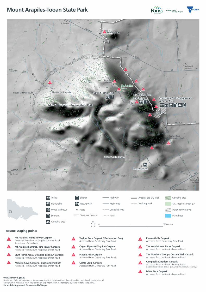
Getting there Mt Arapiles-Tooan State Park is 334km northwest of Melbourne, with access via the Wimmera Highway and Centenary Park Road. The nearest town supplies are Natimuk and major town is Horsham.
Things to see and do Walking
Circuit Walk 15.0km, 3 hrs one way
Starting and ending at Centenary Park Campground & Picnic Area, this mostly flat walk follows the park boundary. The walk takes in a changing landscape, views of the region and has access to the Mt Arapiles Summit via short but steep paths at the end of the circuit.
Gully Loop Walk 4.0km, 1 hr one way
The Pharos Gully and Central Gully walking tracks can be combined into a loop walk and feature some spectacular views.
Nature Walk 1.0km, 30min circuit
This short track on the Summit Road features spring wildflowers on an easy walk.
Rock climbing
Mt Arapiles is a world-renowned rock climbing area. More than 3000 routes have been established on the many cliffs, crags and pinnacles, presenting variety and challenge for all levels of experience. A range of commercial climbing guides available from the Natimuk Post Office or the Arapiles Mountain Shop in Natimuk.
Climbing should only be undertaken by climbers with experience and training, or under the guidance of skilled and qualified instructors.
Mt Arapiles is much loved and sees many thousands of visitors annually. Please support the long-term sustainability of climbing here by respecting the park and other visitors. Stay on existing tracks, avoid damaging vegetation and the rock, and respect cultural sites.
Driving and cycling
The gravel vehicle track circling Mt Arapiles is suitable for driving and cycling.It is a good way to take in the spring wildflowers. In winter only the eastern end of the track is opened to vehicles.
Camping
Centenary Park Campground is the only place to camp in the park. There are three camping areas here with toilets and picnic tables.
The Lower Gums Camping Area is set among Yellowgum planted in the late 1980s and is popular with school groups.
Upper Gums Camping Area is set among remnant Yellowgum woodland and is the smallest of the three campgrounds.
The Pines Camping Area is set among tall pine trees.
The Upper Gums and Pines camping areas have fireplaces but please note firewood is not supplied and firewood collection is prohibited.
Wood fires are not permitted in the park from 1 November to 30 April. Gas or fuel stoves are recommended .
Camping fees apply. For further information or to book go to www.parks.vic.gov.au/stay or call 13 1963.
Picnics
Centenary Park picnic area has a shelter, picnic tables, toilets and wood barbecues (bring your own firewood). The Bluff and Summit picnic areas have tables and spectacular views but no toiltes.
Facilities Visitors should bring their own drinking water.
The Bluff and Summit picnic areas do not have toilets.
Collection of firewood is prohibited in the park – please bring your own wood, or preferably a gas or fuel stove.
Please take all rubbish away for disposal or recycling.
Be prepared and stay safe Mt Arapiles-Tooan State Park is in the Wimmera fire district. Bushfire safety is a personal responsibility. Anyone entering parks and forests during the bushfire season needs to stay aware of forecast weather conditions. Check the Fire Danger Rating and for days of Total Fire Ban at www.emergency.vic.gov.au or call the VicEmergency Hotline on 1800 226 226. No fires may be lit on Total Fire Ban days.
On Code Red Fire Danger Rating days this park will be closed for public safety. Closure signs will be erected but do not expect an official warning. Check the latest conditions at www.parks.vic.gov.au or by calling 13 1963. For emergency assistance call Triple Zero (000). If there is a green emergency marker sign near you, read the information on the marker to the operator.
Mt Arapiles-Tooan State Park Visitor Guide
Dalkaiana Wartaty Dyurrait – Welcome to Mt Arapiles. The Traditional Owners of this land; the Wotjobaluk, Wergaia, Jadawadjali, Jaadwa and Jupagalk people welcome you. Mt Arapiles is a spectacular feature, rising sharply from the Wimmera plains. It is one of Australia’s premier rock climbing areas, and a valuable nature conservation area, with 14% of the State’s flora species represented in the Mt Arapiles section alone.
130
130
130130
130
130
320
320
120
120
1 20
120
340
180
150
150
150
150
150
150
150
150
15
0
180
180
180
180
180
210
210
210
210
220
220220
220
250
250
250
250
290
290
290
310
310
310
330
190
190
190
190
190
230
230
230
230
230
240
240
240
240
240
260
260
260
260
260
270
270
270
270
280
280
280
200
200
200
200
200
180
160
160
160
160
160
160
160
280
290
300
300
300
330
330
200
170130
130
130
130
130
290300
310320
220
140
140
140
140
140
140
140
140
170
170
170
170
170
170
190
230
280
320
330
19
0
310
170
Basin
Basin
Creek
MitreDam
NATIMUK GOLF
LINKS
MT
ARAPILES
TKPHAROS GULLY
SUMMIT
RD
CEN
TENA
RY
PAR
K
AR
APILES
GR
ASS
FLAT
RD
MIT
RE
DA
MR
D
RD
NATIMUK
FRANCES
RD
MCCLURES
RD
WIMMERA
HWY
LAK
E
RD
MCCLURES RD
RD
ARAPILES LN
CEN
TRA L GULLY TK
W
ALK
CIRCUIT WALK
GU
LLY
LOOP
CIRCUIT WALK
TelstraRepeaterStation
Taylors Rock(Declaration Crag)
Campbells KingdomMajor Mitchell Cairn
To Edenhope
To Tooan
ToNatimuk &
Horsham
ToNatimuk &Horsham
ToNatimuk
To Goroke
Mt Arapiles369m
Summit Picnic Area
Mitre Rock
Bluff Picnic Area& Lookout Centenary Park Campground
& Picnic Area
Melville Cave
Nature Walk
Mount Arapiles - Tooan State Park
Mitre DamL.R
Natimuk Golf Course
Toilets
Picnic table
BBQ (wood)
Lookout
Camping
Shelter
Gate
Highway
Main road
Walking track
Seasonal closure
Arapiles Big Sky Trail
Other ParksVictoria land
Waterbody
Camping area
Mount Arapiles-Tooan State Park
Kilometres0 21
Toilets Shelter Highway
Picnic table Nature walk Main road
Wood barbecue Gate Unsealed road
Lookout 4WD
Camping area
Walking track
Seasonal closure
Arapiles Big Sky Trail
Mt. Arapiles Tooan S.P.
Other park/reserve
Waterbody
Camping area
www.parks.vic.gov.auDisclaimer: Parks Victoria does not guarantee that this data is without flaw of any kind and therefore disclaims all liability which may arise from you relying on this information. Cartography by Parks Victoria June 2019.For mobile App search for Avenza PDF Maps
0 1,000 2,000 3,000
1
2
3
4
5
6
7
8
9
10
11
12
13
1
2
3
4
Mt Arapiles Telstra Tower CarparkAccessed From Mount Arapiles Summit Road(locked gate - PV has keys)
Rescue Staging points
Mt Arapiles Summit / Fire Tower CarparkAccessed From Mount Arapiles Summit Road
Melville Cave Carpark / Bushrangers BluffAccessed From Mount Arapiles Summit Road
Bluff Picnic Area / Disabled Lookout CarparkAccessed From Mount Arapiles Summit Road
5
6
7
8
Taylors Rock Carpark / Declaration CragAccessed From Centenary Park Road
Organ Pipes to King Rat CarparkAccessed From Centenary Park Road
Plaque Area CarparkAccessed From Centenary Park Road
Castle Crag CarparkAccessed From Centenary Park Road
9
10
11
12
13
Pharos Gully CarparkAccessed From Centenary Park Road
The Watchtower Faces CarparkAccessed From Natimuk - Frances Road
The Northern Group / Curtain Wall CarparkAccessed From Natimuk - Frances Road
Campbells Kingdom CarparkAccessed From Natimuk - Frances Road(Seasonal Road Closure - Locked gate June to November, PV have keys)
Mitre Rock CarparkAccessed From Natimuk - Frances Road