Msunduzi Final Draft Environmental Management Framework · Final Draft Environmental Management...
62
Msu D Departme unduzi Final Draft Enviro Management Fra Report P Department of Environmenta ent of Agriculture and Envir Affairs and Rural Developm Msunduzi Mu Report No 37699 onmental amework Prepared for al Affairs, ronmental ment, and unicipality 98/FDEMF May 2010
Transcript of Msunduzi Final Draft Environmental Management Framework · Final Draft Environmental Management...
Msunduzi
Department of Environmental Affairs,
Department of Agriculture and Environmental
Msunduzi Final Draft Environmental Management Framework
Report Prepared for
Department of Environmental Affairs,
Department of Agriculture and Environmental Affairs and Rural Development
Msunduzi Municipality
Report No 376998/
Environmental Management Framework
Report Prepared for
Department of Environmental Affairs,
Department of Agriculture and Environmental and Rural Development, and
Msunduzi Municipality
376998/FDEMF
May 2010
SRK Consulting Msunduzi Final Draft EMF Page i
Eman/ allan 376998_Final Draft EMF_May2010 May 2010
Msunduzi Final Draft Environmental Management Framework
Department of Environmental Affairs,
Department of Agriculture and Environmental Affairs and Rural Development, and
Msunduzi Municipality
SRK Project Number: 376998 SRK Consulting
Suite 201 Sinodale Centre 345 Burger Street
Pietermaritzburg, 3201 South Africa
P O Box 460
Pietermaritzburg 3200
South Africa
Tel: (033) 345-6311 Fax: (033) 345-6403
May 2010
Compiled by: Reviewed by: ___________________ __________________ ___________________ P. Emanuel Pr.Sci.Nat K. Allan M. J. Morris Pr.Eng Environmental Scientist Environmental Scientist Partner
SRK Consulting Msunduzi Final Draft EMF Page ii
Eman/ allan 376998_Final Draft EMF_May2010 May 2010
Executive Summary The Msunduzi Municipality (Msunduzi), in partnership with the national Department of
Environmental Affairs (DEA) and the KwaZulu-Natal Department of Agriculture and Environmental
Affairs and Rural Development (DAEA&RD), has recognised the need for an appropriate policy to
inform development planning that supports sustainable development within the Municipality. SRK
Consulting (SRK) was therefore appointed to prepare the following documentation for Msunduzi:
• Status Quo Analysis (State of the Environment);
• Strategic Environmental Assessment (SEA);
• Environmental Service Plan (ESP) previously referred to as the Municipal Open Space System
(MOSS);
• Strategic Environmental Management Plan (SEMP) and
• Environmental Management Framework (EMF).
This report constitutes the product of the EMF process which was undertaken as part of the greater
project. The objectives of the EMF are to
• Identify areas both suitable and unsuitable for development;
• Provide information to assist decision making on matters such as development applications and
thereby streamline the process;
• Identify sensitive areas that require protection to ensure ecosystem service delivery ;
• Provide environmental goals and mechanisms to achieve such goals.
The objectives were achieved by first identifying and mapping the environmental attributes of
Msunduzi as based on information gathered during the Status Quo phase. A Desired State of the
Environment was also adapted from the SEA Report in order to identify management priorities for
the Municipality and the various attributes contained therein. The Desired State of the Environment
addresses four components of the environment namely the:
• Biophysical;
• Social;
• Economic; and
• Governance components.
To support these specific management priorities land management guidelines have been provided for
each of the attributes. For each of the environmental control zones identified, a list of activities that
are likely to be triggered by development in sensitive areas was developed and is attached as
Appendix 2. The environmental control zones identified within the municipality are as follows:
• Wetland Areas;
• Areas of biodiversity significance;
• Areas of flood risk;
SRK Consulting Msunduzi Final Draft EMF Page iii
Eman/ allan 376998_Final Draft EMF_May2010 May 2010
• Areas of high agricultural potential;
• Areas with steep slopes;
• Areas of water quality constraint;
• Areas of Air Quality constraint;
• Areas of cultural heritage significance; and
• Areas where a lack of service delivery is affecting the environment.
There are three main roleplayers in the development and implementation of the EMF namely DEA,
DAEA&RD and Msunduzi. The EMF provides an operational framework that outlines the roles and
responsibilities of these roleplayers in terms of implementing and reviewing the EMF. The EMF
will be held and used by both Msunduzi and DAEA&RD and in order for it to be used effectively
both DAEA&RD and Msunduzi staff will require additional GIS capacity and training. Msunduzi
will be responsible for updating EMF data and reviewing EMF reports every 5 years.
The EMF is a living document and as this is the first such strategic tool to be developed for
Msunduzi it is likely that in the process of implementation changes will be identified. It is therefore
critical that the EMF be perceived as a dynamic document that should grow and evolve with the
Municipality.
As the EMF is a strategic document it cannot be used to assess impacts at project level. Rather, the
EMF aims to identify opportunities and constraints that will guide site specific studies such as
Environmental Impact Assessments (EIA) as well as municipal scale planning. The EMF also does
not exclude or prevent development applications being made but will be used to inform decision
making and the development application process.
SRK Consulting Msunduzi Final Draft EMF Page iv
Eman/ allan 376998_Final Draft EMF_May2010 May 2010
Table of Contents
1 Introduction .................................................................................................................. 1
1.1 The EMF as part of the greater Msunduzi environmental planning initiative ....................... 1
1.2 Purpose of the EMF ............................................................................................................... 2
1.3 Legal Framework ................................................................................................................... 3
1.4 Structure of the Report .......................................................................................................... 4
2 Study Area and Summary of Environmental Attributes ............................................ 5
2.1 Locality and Extent ................................................................................................................ 5
2.2 Geology and Topography ...................................................................................................... 5
2.3 Soils and Land Capability ...................................................................................................... 6
2.4 Hydrology (Rivers and Wetlands) ......................................................................................... 6
2.5 Biodiversity ............................................................................................................................ 6
2.6 Climate and Air Quality .......................................................................................................... 6
2.7 Cultural Heritage Resources ................................................................................................. 7
2.8 Economic and Spatial drivers ................................................................................................ 7
2.9 Basic Services ....................................................................................................................... 7
2.10 Inter-relationship between attributes ..................................................................................... 8
3 Creation of a Consolidated Environmental Attributes Map (CEAM) and the Spatial Decision Support Tool (SDST) .................................................................................. 10
3.1 Introduction .......................................................................................................................... 10
3.2 Process undertaken to produce the CEAM ........................................................................ 10
3.3 Using the SDST ................................................................................................................... 15
4 Environmental Management Priorities ..................................................................... 17
5 Environmental Management Zones .......................................................................... 19
5.1 Definitions ............................................................................................................................ 19
5.2 Wetland Conservation and Buffer Zones ............................................................................ 20 5.2.1 Introduction ............................................................................................................................ 20 5.2.2 Management priorities and land management guidelines .................................................... 20
5.3 Biodiversity Conservation Zones ......................................................................................... 21 5.3.1 Introduction ............................................................................................................................ 21 5.3.2 Management priorities and land management guidelines .................................................... 22
5.4 Flood Risk Zone .................................................................................................................. 23 5.4.1 Introduction ............................................................................................................................ 23 5.4.2 Management priorities and land management guidelines .................................................... 23
5.5 Agricultural Zone ................................................................................................................. 24 5.5.1 Introduction ............................................................................................................................ 24 5.5.2 Management priorities and land management guidelines .................................................... 24
5.6 Slopes .................................................................................................................................. 25 5.6.1 Introduction ............................................................................................................................ 25 5.6.2 Management priorities and land management guidelines .................................................... 26
5.7 Water Quality ....................................................................................................................... 27 5.7.1 Introduction ............................................................................................................................ 27 5.7.2 Management priorities and land management guidelines .................................................... 27
5.8 Air Quality ............................................................................................................................ 28 5.8.1 Introduction ............................................................................................................................ 28 5.8.2 Management priorities and land management guidelines .................................................... 29
5.9 Cultural Heritage Zones ...................................................................................................... 29 5.9.1 Introduction ............................................................................................................................ 29 5.9.2 Management priorities and land management guidelines .................................................... 29
5.10 Service Delivery Zones ....................................................................................................... 30 5.10.1 Introduction ............................................................................................................................ 30 5.10.2 Management priorities ........................................................................................................... 31
SRK Consulting Msunduzi Final Draft EMF Page v
Eman/ allan 376998_Final Draft EMF_May2010 May 2010
6 Implementation and Review ...................................................................................... 32
6.1 Introduction .......................................................................................................................... 32
6.2 Roles and Responsibilities .................................................................................................. 32 6.2.1 DEA ....................................................................................................................................... 32 6.2.2 DAEA&RD ............................................................................................................................. 33 6.2.3 Msunduzi Municipality ........................................................................................................... 33
6.3 Capacity, Training and Awareness ..................................................................................... 34
6.4 Documentation and Record Keeping .................................................................................. 34 6.4.1 Data Upkeep ......................................................................................................................... 35
7 Public Involvement ..................................................................................................... 36
8 Conclusion .................................................................................................................. 46
9 References ..................................................................................................................... 47
Appendices ...................................................................................................................... 49
Appendix 1 Maps ......................................................................................................................... 49
Appendix 2 Listed Activities in terms of the NEMA EIA Regulations .......................................... 50
List of Tables
Table 1.1: Report Structure ................................................................................................................. 4
Table 3-1: Descriptions used for describing the constraints for the specialist studies ..................... 11
Table 3-2: Ratings used for the attribute tables of the specialist studies ......................................... 12
Table 3-3: The rankings used to determine the Predominant Sensitivity ......................................... 12
Table 4.1: Sustainability Objectives and Criteria .............................................................................. 17
Table 7.1: Comments received in the SEA and associated Responses .......................................... 36
List of Figures
Figure 1.1: EMF Phases ....................................................................................................................... 2
Figure 2.1: Msunduzi Municipality Locality Map .................................................................................. 5
Figure 3-1: Intersection of layers ....................................................................................................... 13
Figure 3-2: Symbology used in the SDST Layer and associated sensitivity codes ......................... 14
Figure 3.3: Example of the SDST report generated in ArcMap ........................................................ 16
Figure 6-1: Schematic of institutional role-players interaction .......................................................... 32
G:\Proj\376998_MSunduzi EMF_EMAN_ISO\7) Reports\EMF\376998_Final Draft EMF_May2010.docx
1
06 May 2010
376998
Msunduzi Final Draft Environmental Management Framework
1 Introduction The Msunduzi Municipality (Msunduzi), in partnership with the national Department of
Environmental Affairs (DEA) and the KwaZulu-Natal Department of Agriculture and Environmental
Affairs and Rural Development (DAEA&RD),has recognised that to support sustainable social,
economic and environmental development within the Municipality, the adoption and implementation
of an appropriate policy to inform development planning and approval is required. To address these
requirements, the preparation of an Environmental Management Framework (EMF) is being
undertaken by SRK Consulting (SRK). The Msunduzi EMF includes a Status Quo Analysis, a
Strategic Environmental Assessment (SEA), a Municipal Open Space System (MOSS), now referred
to as the Environmental Services Plan (ESP), a Strategic Environmental Management Plan (SEMP)
and GIS based Spatial Decision Support Tool (SDST) for Msunduzi.
This report constitutes the product of the EMF component of the greater Msunduzi EMF Project.
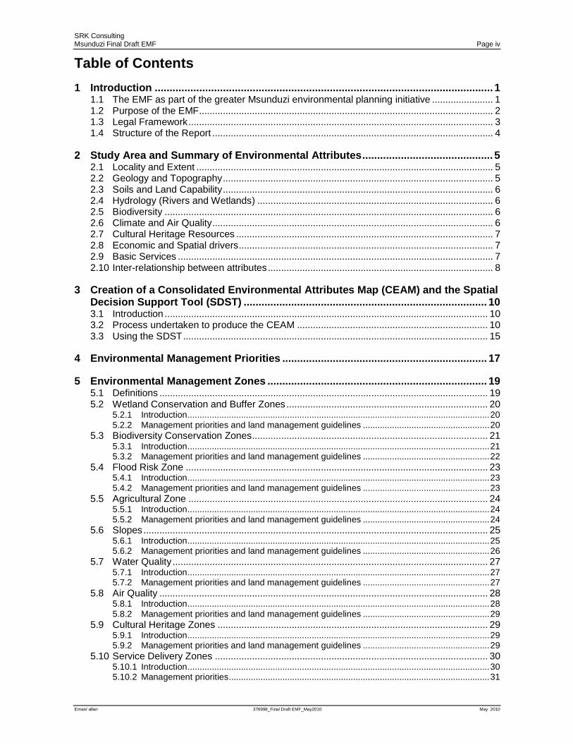
1.1 The EMF as part of the greater Msunduzi environmental planning initiative
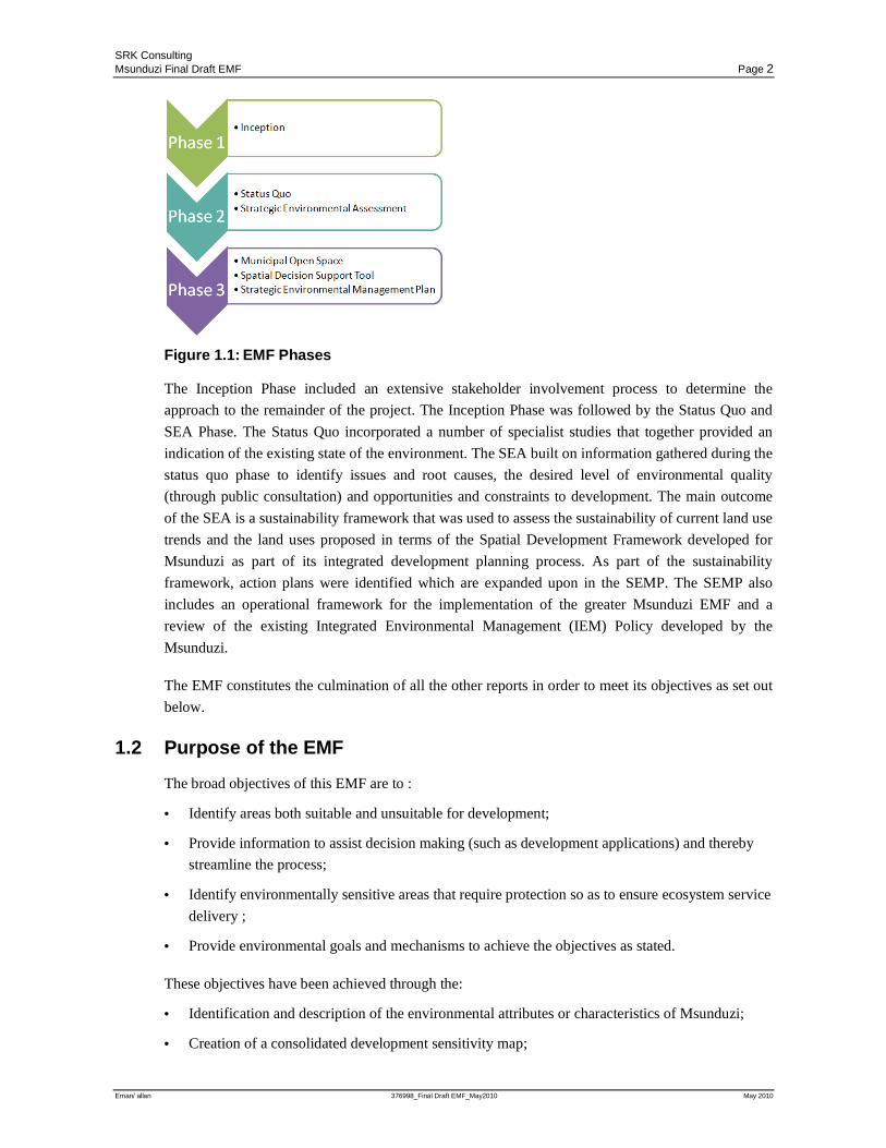
The purpose of the greater Msunduzi EMF project is to provide for informed decision making and a
framework against which plans, programs and policies can be assessed in the future. The Msunduzi
EMF consisted of 3 Phases as indicated in Figure 1.1 below. The EMF Report, i.e. this report, forms
part of Phase 3 of the Msunduzi EMF project.
SRK Consulting Msunduzi Final Draft EMF Page 2
Eman/ allan 376998_Final Draft EMF_May2010 May 2010
Figure 1.1: EMF Phases
The Inception Phase included an extensive stakeholder involvement process to determine the
approach to the remainder of the project. The Inception Phase was followed by the Status Quo and
SEA Phase. The Status Quo incorporated a number of specialist studies that together provided an
indication of the existing state of the environment. The SEA built on information gathered during the
status quo phase to identify issues and root causes, the desired level of environmental quality
(through public consultation) and opportunities and constraints to development. The main outcome
of the SEA is a sustainability framework that was used to assess the sustainability of current land use
trends and the land uses proposed in terms of the Spatial Development Framework developed for
Msunduzi as part of its integrated development planning process. As part of the sustainability
framework, action plans were identified which are expanded upon in the SEMP. The SEMP also
includes an operational framework for the implementation of the greater Msunduzi EMF and a
review of the existing Integrated Environmental Management (IEM) Policy developed by the
Msunduzi.
The EMF constitutes the culmination of all the other reports in order to meet its objectives as set out
below.
1.2 Purpose of the EMF
The broad objectives of this EMF are to :
• Identify areas both suitable and unsuitable for development;
• Provide information to assist decision making (such as development applications) and thereby
streamline the process;
• Identify environmentally sensitive areas that require protection so as to ensure ecosystem service
delivery ;
• Provide environmental goals and mechanisms to achieve the objectives as stated.
These objectives have been achieved through the:
• Identification and description of the environmental attributes or characteristics of Msunduzi;
• Creation of a consolidated development sensitivity map;
SRK Consulting Msunduzi Final Draft EMF Page 3
Eman/ allan 376998_Final Draft EMF_May2010 May 2010
• Creation of an interactive software interface (using GIS software) that allows for reporting on 9
attributes based on their geographical locations;
• Identification of management priorities for each attribute:
• Identification of listed activities that may be triggered by development within areas where the
environmental attributes exist; and
• Identification of the preferred and non preferred land use where environmental attributes exist.
1.3 Legal Framework
The development and adoption of EMF’s is detailed in Part 1 of Chapter 8: General Matters of the
Environmental Impact Assessment (EIA) Regulations of 2006 promulgated in terms of National
Environmental Management Act, No. 107 of 1998 (NEMA).
Section 71 of the regulations states that a draft EMF must:
• “Identify by way of map or otherwise, the geographical area to which it applies;
• Specify the attributes of the environment in the area, including the sensitivity, extent,
interrelationship and significance of those attributes;
• Indentify any parts in the area to which those attributes relate;
• State the conservation status of the area and in those parts;
• State the environmental management priorities of the area;
• Indicate the kinds of activities that would have significant impact on those attributes and those
that would not;
• Indicate the kind of activities that would be undesirable in the area or in specific parts of the
area; and
• Include any other matters that may be specified.”
In addition to the requirements as listed in the NEMA EIA Regulations a review of the legislation
pertaining to the development of the EMF and all environmental attributes detailed in the EMF was
undertaken in the Status Quo phase of the project. Legislation and policy identified at an
international, national, provincial and local level is detailed in the Institutional Report included as
Appendix 1 of the Status Quo Report.
The EMF Report, i.e. this report, has been designed to meet these requirements, as illustrated in
Table 1.1 below.
SRK Consulting Msunduzi Final Draft EMF Page 4
Eman/ allan 376998_Final Draft EMF_May2010 May 2010
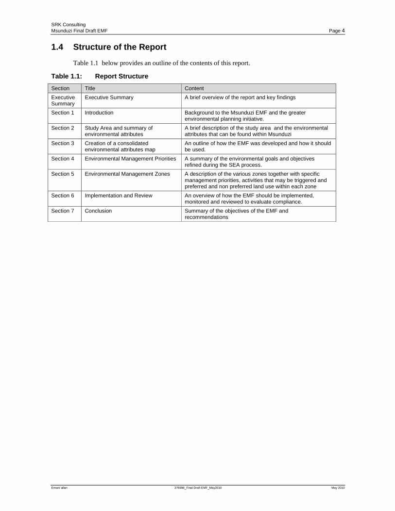
1.4 Structure of the Report
Table 1.1 below provides an outline of the contents of this report.
Table 1.1: Report Structure
Section Title Content
Executive Summary
Executive Summary A brief overview of the report and key findings
Section 1 Introduction Background to the Msunduzi EMF and the greater environmental planning initiative.
Section 2 Study Area and summary of environmental attributes
A brief description of the study area and the environmental attributes that can be found within Msunduzi
Section 3 Creation of a consolidated environmental attributes map
An outline of how the EMF was developed and how it should be used.
Section 4 Environmental Management Priorities A summary of the environmental goals and objectives refined during the SEA process.
Section 5 Environmental Management Zones A description of the various zones together with specific management priorities, activities that may be triggered and preferred and non preferred land use within each zone
Section 6 Implementation and Review An overview of how the EMF should be implemented, monitored and reviewed to evaluate compliance.
Section 7 Conclusion Summary of the objectives of the EMF and recommendations
SRK Consulting Msunduzi Final Draft EMF Page 5
Eman/ allan 376998_Final Draft EMF_May2010 May 2010
2 Study Area and Summary of Environmental Attributes
2.1 Locality and Extent
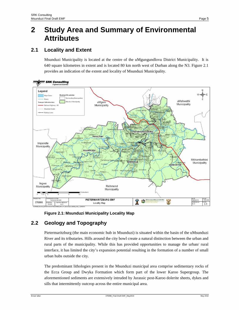
Msunduzi Municipality is located at the centre of the uMgungundlovu District Municipality. It is
640 square kilometres in extent and is located 80 km north west of Durban along the N3. Figure 2.1
provides an indication of the extent and locality of Msunduzi Municipality.
Figure 2.1: Msunduzi Municipality Locality Map
2.2 Geology and Topography
Pietermaritzburg (the main economic hub in Msunduzi) is situated within the basin of the uMsunduzi
River and its tributaries. Hills around the city bowl create a natural distinction between the urban and
rural parts of the municipality. While this has provided opportunities to manage the urban/ rural
interface, it has limited the city’s expansion potential resulting in the formation of a number of small
urban hubs outside the city.
The predominant lithologies present in the Msunduzi municipal area comprise sedimentary rocks of
the Ecca Group and Dwyka Formation which form part of the lower Karoo Supergroup. The
aforementioned sediments are extensively intruded by Jurassic post-Karoo dolerite sheets, dykes and
sills that intermittently outcrop across the entire municipal area.
SRK Consulting Msunduzi Final Draft EMF Page 6
Eman/ allan 376998_Final Draft EMF_May2010 May 2010
2.3 Soils and Land Capability
Soils within the Municipality vary greatly. The topography, rainfall patterns and geology have
resulted in the high agricultural potential of the area. However large portions of highly productive
agricultural land have been developed for other uses such as housing. The remaining areas of highly
productive agricultural land mainly occur on communally owned land in the Vulindlela area. Poor
agricultural practices in these areas are affecting the productivity of the land.
2.4 Hydrology (Rivers and Wetlands)
Msunduzi Municipality constitutes almost entirely one catchment which assists in catchment
management but means that any impact within the Municipality has the potential to affect the main
Msunduzi River. Water quality varies between sub-catchments but the impact of the city is evident
from the decrease in water quality that occurs as it passes through the urbanised portions of the
municipality. The decrease in water quality compromises development opportunities in the
municipality such as the Duzi Canoe Marathon.
The extent of wetlands within Msunduzi has declined significantly in recent years, particularly in
developed areas. Wetlands have been transformed and most of the remaining wetlands are degraded.
Wetlands provide a number of ecosystem goods and services critical for the realisation of social and
economic development goals.
2.5 Biodiversity
The topography, geology and other land characteristics in the Msunduzi have also given rise to
diverse habitats and species richness. High levels of transformation have however resulted in a
significant loss of natural habitat. A relatively low proportion of the municipality is regarded as
“untransformed”, nevertheless it is at a level where most conservation targets can still be met. In
order to continue to meet conservation targets, however, approximately 20 186 ha or 31.7% of the
municipal area requires conservation.
Significant biodiversity features include a total of 56 animal species, 20 plant species and 8
vegetation types. At least 50 endemic species occur in the area. A high number of rare or threatened
species occur within the Msunduzi Municipality and three species are thought to have become
extinct. A number of important aquatic biodiversity features have been identified that require
conservation including endemic fish species that raise the ecological value of sub-catchments. At
least 28 species of frogs have previously been recorded within the municipal region although it is not
certain that all of these still do exist here and most are red data species.
2.6 Climate and Air Quality
The climate and local weather in Msunduzi are strongly influenced by topography; the higher lying
areas in the north and west of the municipality are colder and receive more rainfall than the lower
lying areas in the south and east. The Pietermaritzburg city is located in a hollow formed by the
valleys of the uMsunduzi River and its tributaries. On clear winter nights cold dense air flows down
slope into the city bowl, much like water. This fills the valley floor with cold, dense air creating an
SRK Consulting Msunduzi Final Draft EMF Page 7
Eman/ allan 376998_Final Draft EMF_May2010 May 2010
inversion that prevents pollutants from escaping. This air movement also brings pollutants from the
entire municipal area into the valley where it remains trapped by the inversion layer.
The majority of industry within Msunduzi has developed within this inversion layer as this land is
both flat and in close proximity to both road and rail transport routes. As a result the city suffers
short-term peaks in pollution despite relatively few heavy industries.
2.7 Cultural Heritage Resources
Msunduzi has an extremely rich cultural, architectural, historical and archaeological resource base
that collectively makes up the heritage resources of the area. A Cultural Heritage Specialist Study
was undertaken as part of the Status Quo phase of the greater EMF project and 646 heritage resource
points and 32 heritage resource zones where identified within the Msunduzi Municipal area.
Identified cultural heritage sites consist mainly of European sites while many African and Indian
Cultural heritage sites may not yet have been identified. The unidentified sites are at risk of being
lost.
2.8 Economic and Spatial drivers
Msunduzi is characterised by a complex racial mix and is a typical South African city divided by
both income and race. Population growth in Msunduzi is higher than the national average, as a result
of urbanisation. Rapid population growth is one of the major contributing factors to biophysical and
socio economic issues within the Municipality.
In terms of national and provincial policies, Pietermaritzburg has been identified as a focal area for
development and economic growth. The N3 route has been identified as a provincial priority
corridor. This, in turn, creates urbanization and economic development pressures on Msunduzi. The
population of the Municipality has increased significantly (18 %) since 1996 and this is expected to
continue. Based on the trends identified above, it is anticipated that the pressure on land available for
development and the demand for employment opportunities and social facilities will increase.
Economic drivers within Msunduzi offer significant opportunities for growth. However ecosystem
goods and services provided by the environment are required to support this growth and it is critical
that a balance be reached between development and conservation. Without this balance ecosystem
goods and services will be lost and development opportunities along with them.
2.9 Basic Services
The Msunduzi municipal area of jurisdiction has increased dramatically with the creation of wall to
wall municipalities. This process increased the jurisdiction of municipalities to include established
urban areas like Pietermaritzburg with surrounding relatively undeveloped rural areas like
Vulindlela. Resource capacity within the municipality has however not increased proportionally to
deal with this greater responsibility. The municipality has also lost key staff with extensive
experience and if and when replaced new staff often lack the requisite experience. This has impacted
on Municipal service delivery. The lack of service delivery not only affects residents’ quality of life
but also the environment. An example of this is the impact poor sanitation maintenance has on water
quality in the Msunduzi River. Whilst certain areas within Pietermaritzburg have good service
SRK Consulting Msunduzi Final Draft EMF Page 8
Eman/ allan 376998_Final Draft EMF_May2010 May 2010
provision, aging infrastructure, lack of capacity and maintenance issues are impacting negatively on
service delivery. Msunduzi is in the process of extending service to areas outside Pietermaritzburg,
but the backlog in service delivery is a concern.
2.10 Inter-relationship between attributes
Individual aspects of the environment have been described above. In order to manage these resources
effectively it is necessary to assess them strategically. Air, water, and land are inter connected by
natural cycles and the ecological conditions of the area result from the sum total of the physical,
chemical and biological components of ecosystems and how they interact. Understanding the
ecological conditions of the area is crucial as ecosystems provide goods and services that support
human well being and economic growth in the Msunduzi Municipality.
The interrelationship between environmental attributes, including social, economic, environmental
and governance aspects, is highly complicated as each attribute is affected and influenced by, or
affects and influences all other environmental attributes. Key environmental issues identified within
the Msunduzi area have overlapping causes and through compounding interactions these have
complex cumulative effects.
For example, poor environmental governance, caused by issues such as a lack of capacity;
insufficient funding; a lack of cooperative governance; and political interference and corruption,
result in impacts such as ineffective compliance; poor service delivery; and uninformed and/or poor
decision making. These impacts interacting with other aspects of the environment have significant
cumulative effects including land degradation and inappropriate land use; increasing air and water
pollution; decline in environmental quality and associated human health and well-being; and the
perpetuation of poverty and environmental injustice.
A detailed cause-effect matrix of interaction amongst environmental aspects is provided in Table 4.1
in the SEA Report.
A key cumulative effect of environmental degradation resulting from continuing on an unsustainable
development path is the perpetuation of poverty and environmental injustice. It is important to
recognise a clear linkage between the environment and poverty.
The environment affects poverty in three ways: Firstly, by providing a source of livelihoods to poor
people; secondly, by affecting their health and well-being; and, lastly by influencing their
vulnerability to risk. Poverty, in its turn, also affects the environment in a number of ways. It may
force poor people to degrade the environment in order to maintain their livelihood. It may also
promote economic growth at the expense of the environment. Similarly, the desire to address poverty
induces decision makers to downgrade environmental concerns, including failure
to channel sufficient resources to address these concerns.
Because of the nature of environmental degradation, it is the poor who bear the brunt of this impact.
Impoverishment pushes them to the most ecologically fragile lands and they are the most vulnerable
to environmental risks such as pollution and natural disasters. The effect of biodiversity loss is most
severe for rural and impoverished communities as they depend directly on natural resources for their
SRK Consulting Msunduzi Final Draft EMF Page 9
Eman/ allan 376998_Final Draft EMF_May2010 May 2010
livelihood, energy, and medicinal needs. Environmental degradation, by depleting the health and
natural support systems of poor people, renders them even more vulnerable.
Economic growth is critical to both poverty reduction and environmental sustainability. But such
growth must be pro-poor and resource-saving. Efficiency in resource use is crucial for two reasons:
firstly, it releases resources that can be devoted to poverty reduction; and, secondly, it reduces
environmental degradation.
SRK Consulting Msunduzi Final Draft EMF Page 10
Eman/ allan 376998_Final Draft EMF_May2010 May 2010
3 Creation of a Consolidated Environmental Attributes Map (CEAM) and the Spatial Decision Support Tool (SDST)
3.1 Introduction
In the early stages of the project it was recognised that an integration of the identified environmental
sensitivities in a format that consolidates the extensive volumes of data was necessary. This
integrated dataset is needed to retain the context, enable relatively simple interpretation and
interrogation and facilitate decision making. In addition, the identified key users, namely Msunduzi
and DAEA &RD, have different requirements as to the decisions the data would support.
Functionality to facilitate this process is necessary.
The first component or layer in this format this was the development of a summarised layer termed
the Consolidated Environmental Attributes Map (CEAM). The CEAM is a GIS layer, which is the
consolidation of environmentally sensitive attributes determined in the nine specialist studies
conducted during the Msunduzi EMF Study. It provided the user with a visual representation of
sensitivity issues at any one particular point or perspective.
To facilitate the interpretation of the CEAM, a Spatial Decision Support Tool (SDST) was
developed to aid in the identification of developmental constraints/environmental sensitivities in the
Msunduzi Municipality, thus providing a better understanding of potential mitigation measures
needed at specific locations.
3.2 Process undertaken to produce the CEAM
The following section outlines steps taken to produce the final CEAM layer and the SDST.
Data used in the CEAM originated from the specialist studies undertaken during the Status Quo
phase of the Msunduzi EMF Project.
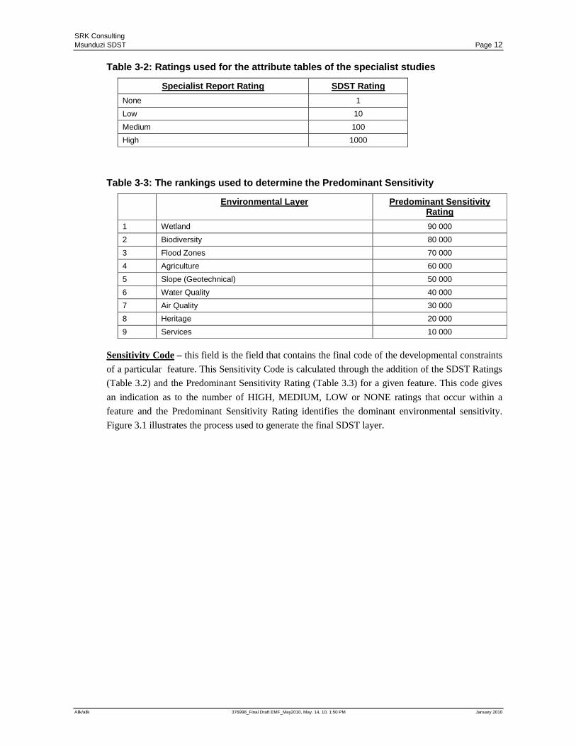
Ratings: Each specialist study defined areas that had environmental sensitivity which were then
allocated a rating, namely HIGH, MEDIUM, LOW and NONE. These ratings are outlined in Table
3-1 and the numerical value assigned to each is indicated in Table 3-2.
Predominant Sensitivity – Where more than one sensitivity is identified for a particular area the
dominant sensitivity was given priority in the rating as shown in Table 3.1. For example, if a feature
was ranked as having a HIGH constraint in terms of Biodiversity, the predominant constraint would
thus be reflected as Biodiversity. If a feature had a MEDIUM Biodiversity constraint but a HIGH
Flood Zone constraint, the predominant constraint reflected would thus be Flood Zones. Each feature
was classified in terms of the hierarchy reflected in Table 3-3 to determine the predominant field.
SRK Consulting Msunduzi SDST Page 11
Allk/allk 376998_Final Draft EMF_May2010, May. 14, 10, 1:50 PM January 2010
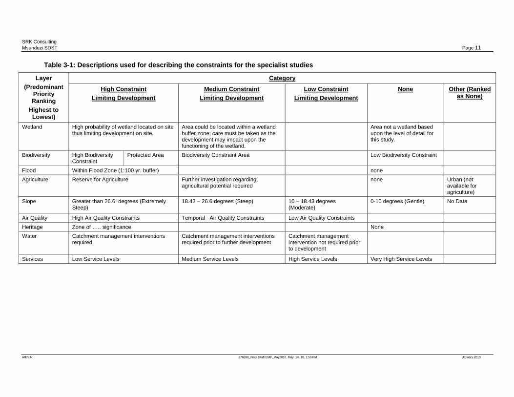
Table 3-1: Descriptions used for describing the constraints for the specialist studies
Layer (Predominant
Priority Ranking
Highest to Lowest)
Category
High Constraint Limiting Development
Medium Constraint Limiting Development
Low Constraint Limiting Development
None Other (Ranked as None)
Wetland High probability of wetland located on site thus limiting development on site.
Area could be located within a wetland buffer zone; care must be taken as the development may impact upon the functioning of the wetland.
Area not a wetland based upon the level of detail for this study.
Biodiversity High Biodiversity Constraint
Protected Area Biodiversity Constraint Area Low Biodiversity Constraint
Flood Within Flood Zone (1:100 yr. buffer) none
Agriculture Reserve for Agriculture Further investigation regarding agricultural potential required
none Urban (not available for agriculture)
Slope Greater than 26.6 degrees (Extremely Steep)
18.43 – 26.6 degrees (Steep) 10 – 18.43 degrees (Moderate)
0-10 degrees (Gentle)
No Data
Air Quality High Air Quality Constraints Temporal Air Quality Constraints Low Air Quality Constraints
Heritage Zone of ….. significance None
Water Catchment management interventions required
Catchment management interventions required prior to further development
Catchment management intervention not required prior to development
Services Low Service Levels Medium Service Levels High Service Levels Very High Service Levels
SRK Consulting Msunduzi SDST Page 12
Allk/allk 376998_Final Draft EMF_May2010, May. 14, 10, 1:50 PM January 2010
Table 3-2: Ratings used for the attribute tables of the specialist studies
Specialist Report Rating SDST Rating
None 1
Low 10
Medium 100
High 1000
Table 3-3: The rankings used to determine the Predominant Sensitivity
Environmental Layer Predominant Sensitivity Rating
1 Wetland 90 000
2 Biodiversity 80 000
3 Flood Zones 70 000
4 Agriculture 60 000
5 Slope (Geotechnical) 50 000
6 Water Quality 40 000
7 Air Quality 30 000
8 Heritage 20 000
9 Services 10 000
Sensitivity Code – this field is the field that contains the final code of the developmental constraints
of a particular feature. This Sensitivity Code is calculated through the addition of the SDST Ratings
(Table 3.2) and the Predominant Sensitivity Rating (Table 3.3) for a given feature. This code gives
an indication as to the number of HIGH, MEDIUM, LOW or NONE ratings that occur within a
feature and the Predominant Sensitivity Rating identifies the dominant environmental sensitivity.
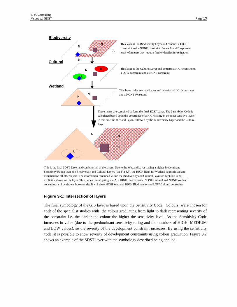
Figure 3.1 illustrates the process used to generate the final SDST layer.
SRK Consulting Msunduzi SDST Page 13
Figure 3-1: Intersection of layers
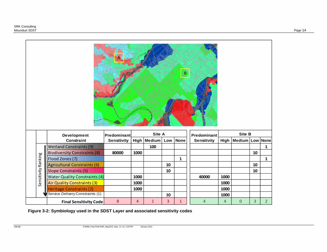
The final symbology of the GIS layer is based upon the Sensitivity Code. Colours were chosen for
each of the specialist studies with the colour graduating from light to dark representing severity of
the constraint i.e. the darker the colour the higher the sensitivity level. As the Sensitivity Code
increases in value (due to the predominant sensitivity rating and the numbers of HIGH, MEDIUM
and LOW values), so the severity of the development constraint increases. By using the sensitivity
code, it is possible to show severity of development constraints using colour graduation. Figure 3.2
shows an example of the SDST layer with the symbology described being applied.
A
B
Biodiversity
Cultural
Wetland
HN
HN
L
HN
NH
H
L
These layers are combined to form the final SDST Layer. The Sensitivity Code is
calculated based upon the occurrence of a HIGH rating in the most sensitive layers,
in this case the Wetland Layer, followed by the Biodiversity Layer and the Cultural
Layer.
This layer is the Wetland Layer and contains a HIGH constraint
and a NONE constraint.
This layer is the Cultural Layer and contains a HIGH constraint,
a LOW constraint and a NONE constraint.
This layer is the Biodiversity Layer and contains a HIGH
constraint and a NONE constraint. Points A and B represent
areas of interest that require further detailed investigation.
This is the final SDST Layer and combines all of the layers. Due to the Wetland Layer having a higher Predominant
Sensitivity Rating than the Biodiversity and Cultural Layers (see Fig 3.3), the HIGH Rank for Wetland is prioritised and
overshadows all other layers. The information contained within the Biodiversity and Cultural Layers is kept, but is not
explicitly shown on the layer. Thus, when investigating site A, a HIGH Biodiversity, NONE Cultural and NONE Wetland
constraints will be shown, however site B will show HIGH Wetland, HIGH Biodiversity and LOW Cultural constraints.
SRK Consulting Msunduzi SDST Page 14
Allk/allk 376998_Final Draft EMF_May2010, May. 14, 10, 1:50 PM January 2010
High Medium Low None High Medium Low None
Wetland Constraints (9) 100 1
Biodiversity Constraints (8) 80000 1000 10
Flood Zones (7) 1 1
Agricultural Constraints (6) 10 10
Slope Constraints (5) 10 10
Water Quality Constraints (4) 1000 40000 1000
Air Quality Constraints (3) 1000 1000
Heritage Constraints (2) 1000 1000Service Delivery Constraints (1) 10 1000
Final Sensitivity Code 8 4 1 3 1 4 4 0 3 2
Site A Site BDevelopment Constraint
Predominant Sensitivity
PredominantSensitivity
A
B
Se
nsi
tiv
ity
Ra
nk
ing
Figure 3-2: Symbiology used in the SDST Layer and associated sensitivity codes
SRK Consulting Msunduzi EMF Page 15
Eman/ allan 376998_Final Draft EMF_May2010 May-10
3.3 Using the SDST
The prime objective of the SDST is to inform the environmental assessment and authorisation
process. The consolidation and representation of various specialist studies into a single entity permit
an uncluttered display of important information.
Once a user has selected an area (defined by a polygon) the SDST aims to provide the user with:
A description of the relevant environmental attributes identified for the selected area. The related
conservation significance associated with the respective constraints/sensitivities.
An outline of recommended management priorities that would need to be taken into account with
regard to the identified constraints/sensitivities that would need to be investigated, in detail, in the
submission for environmental approval.
The SDST can be used in both its software and hardware forms. Both methods enable a user to
obtain site specific information relating to possible development constraints on site.
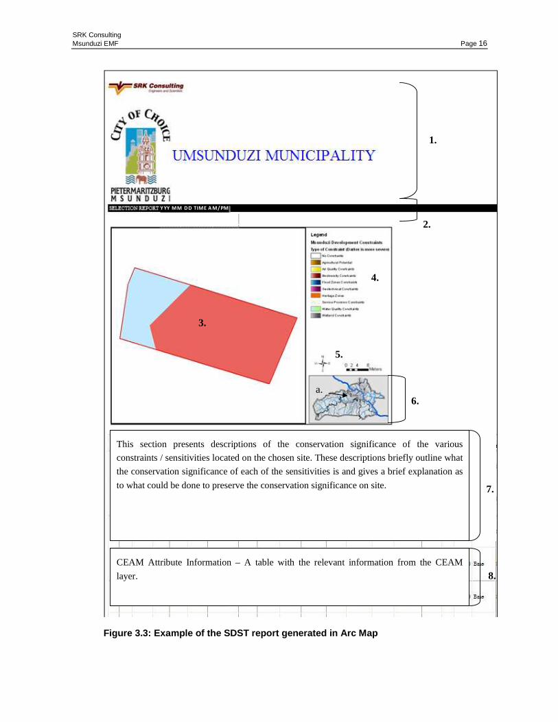
An extract from a typical SDST report is shown below (Figure 3.3), and contains the following
information:
1) The SRK and Msunduzi logos;
2) A time and date stamp, showing the time and the date that the report was generated, the format
for this is Year, Month, Day, Time (AM / PM);
3) The selected property;
4) The CEAM legend;
5) Scale bar and north arrow;
6) An inset map, showing the Municipality and a red block (a) showing where in the Municipality
the site is located;
7) The attribute information for the site-- this table gives all the relevant information from the
attributes of the CEAM layer; and
8) Conservation significance of features on the chosen site.
SRK Consulting Msunduzi EMF Page 16
Figure 3.3: Example of the SDST report generated in Arc Map
Y YY MM DD TIME A M/PM
1.
2.
3.
4.
5.
6. a.
CEAM Attribute Information – A table with the relevant information from the CEAM
layer.
This section presents descriptions of the conservation significance of the various
constraints / sensitivities located on the chosen site. These descriptions briefly outline what
the conservation significance of each of the sensitivities is and gives a brief explanation as
to what could be done to preserve the conservation significance on site. 7.
8.
SRK Consulting Msunduzi EMF Page 17
Eman/ allan 376998_Final Draft EMF_May2010 May-10
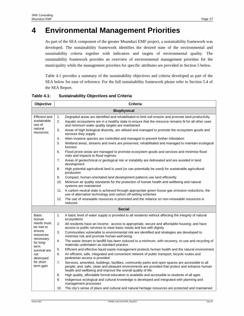
4 Environmental Management Priorities As part of the SEA component of the greater Msunduzi EMF project, a sustainability framework was
developed. The sustainability framework identifies the desired state of the environmental and
sustainability criteria together with indicators and targets of environmental quality. The
sustainability framework provides an overview of environmental management priorities for the
municipality while the management priorities for specific attributes are provided in Section 5 below.
Table 4.1 provides a summary of the sustainability objectives and criteria developed as part of the
SEA below for ease of reference. For the full sustainability framework please refer to Section 5.4 of
the SEA Report.
Table 4.1: Sustainability Objectives and Criteria
Objective Criteria
Biophysical
Efficient and sustainable use of natural resources
1. Degraded areas are identified and rehabilitated to limit soil erosion and promote land productivity 2. Aquatic ecosystems are in a healthy state to ensure that the resource remains fit for all other uses
and minimum water quality targets are maintained 3. Areas of high biological diversity, are utilised and managed to promote the ecosystem goods and
services they supply 4. Alien invasive species are controlled and managed to prevent further infestation 5. Wetland areas, streams and rivers are preserved, rehabilitated and managed to maintain ecological
function 6. Flood prone areas are managed to promote ecosystem goods and services and minimise flood
risks and impacts to flood regimes 7. Areas of geotechnical or geological risk or instability are delineated and are avoided in land
development 8. High potential agricultural land is used (or can potentially be used) for sustainable agricultural
production 9. Compact, human-orientated land development patterns use land efficiently 10. Minimum air quality standards for the protection of human health and wellbeing and natural
systems are maintained 11. A carbon neutral state is achieved through appropriate green house gas emission reductions, the
use of alternative technology and carbon off-setting schemes 12. The use of renewable resources is promoted and the reliance on non-renewable resources is
reduced
Social
Basic human needs must be met to ensure resources necessary for long-term survival are not destroyed for short term gain
1. A basic level of water supply is provided to all residents without affecting the integrity of natural ecosystems
2. All residents have an income; access to appropriate, secure and affordable housing; and have access to public services to meet basic needs and live with dignity
3. Communities vulnerable to environmental risk are identified and strategies are developed to minimise risk and promote human well-being.
4. The waste stream to landfill has been reduced to a minimum, with recovery, re-use and recycling of materials undertaken as standard practice.
5. Efficient and effective liquid waste management protects human health and the natural environment 6. An efficient, safe, integrated and convenient network of public transport, bicycle routes and
pedestrian access is provided 7. Services, amenities, buildings, facilities, community parks and open spaces are accessible to all
people; and, safe, clean and pleasant environments are provided that protect and enhance human health and wellbeing and improve the overall quality of life.
8. High quality, affordable formal education is available and accessible to students of all ages 9. Indigenous ecological and cultural knowledge is developed and integrated with planning and
management processes 10. The city’s sense of place and cultural and natural heritage resources are protected and maintained
SRK Consulting Msunduzi EMF Page 18
Eman/ allan 376998_Final Draft EMF_May2010 May-10
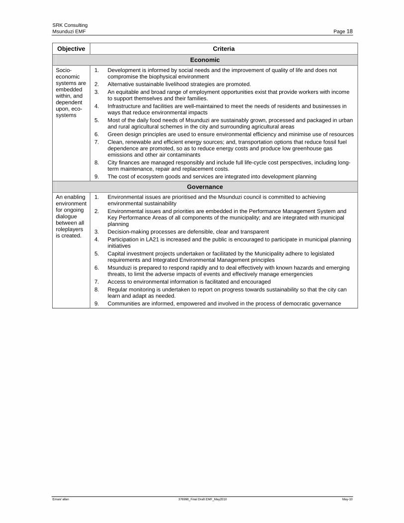
Objective Criteria
Economic
Socio-economic systems are embedded within, and dependent upon, eco-systems
1. Development is informed by social needs and the improvement of quality of life and does not compromise the biophysical environment
2. Alternative sustainable livelihood strategies are promoted. 3. An equitable and broad range of employment opportunities exist that provide workers with income
to support themselves and their families. 4. Infrastructure and facilities are well-maintained to meet the needs of residents and businesses in
ways that reduce environmental impacts 5. Most of the daily food needs of Msunduzi are sustainably grown, processed and packaged in urban
and rural agricultural schemes in the city and surrounding agricultural areas 6. Green design principles are used to ensure environmental efficiency and minimise use of resources 7. Clean, renewable and efficient energy sources; and, transportation options that reduce fossil fuel
dependence are promoted, so as to reduce energy costs and produce low greenhouse gas emissions and other air contaminants
8. City finances are managed responsibly and include full life-cycle cost perspectives, including long-term maintenance, repair and replacement costs.
9. The cost of ecosystem goods and services are integrated into development planning
Governance
An enabling environment for ongoing dialogue between all roleplayers is created.
1. Environmental issues are prioritised and the Msunduzi council is committed to achieving environmental sustainability
2. Environmental issues and priorities are embedded in the Performance Management System and Key Performance Areas of all components of the municipality; and are integrated with municipal planning
3. Decision-making processes are defensible, clear and transparent 4. Participation in LA21 is increased and the public is encouraged to participate in municipal planning
initiatives 5. Capital investment projects undertaken or facilitated by the Municipality adhere to legislated
requirements and Integrated Environmental Management principles 6. Msunduzi is prepared to respond rapidly and to deal effectively with known hazards and emerging
threats, to limit the adverse impacts of events and effectively manage emergencies 7. Access to environmental information is facilitated and encouraged 8. Regular monitoring is undertaken to report on progress towards sustainability so that the city can
learn and adapt as needed. 9. Communities are informed, empowered and involved in the process of democratic governance
SRK Consulting Msunduzi EMF Page 19
Eman/ allan 376998_Final Draft EMF_May2010 May-10
5 Environmental Management Zones The terminology used in following 9 environmental management zones is explained below. For each
of the environmental management zones the following has been provided:
• A map reflecting the distribution of each attribute within the municipality;
• A description of the attribute and its significance;
• The environmental management priorities of the specific attribute; and
• Guidelines for land use based on potential impacts on each of the management zones.
In addition to the reporting as listed above, an indication of the activities that are likely to be
triggered by development in each of the environmental management zones has been provided in
Appendix 2.
5.1 Definitions
The EIA regulations require that an EMF should:
“Indicate the kinds of activities that would have significant impact on those attributes and those that
would not; and
Indicate the kind of activities that would be undesirable in the area or in specific parts of the area;”
To address this, for each environmental management zone below, a list of activities that are likely to
impact on the attribute have been provided in Appendix 2. However the NEMA Duty of Care
Principles also require that:
“Every person who may cause significant … degradation of the environment must take reasonable
measures to prevent such degradation from occurring …or, in so far as such harm to the
environment is authorized by law or cannot reasonably be avoided … to minimize or rectify such …
degradation of the environment”
The Duty of Care Principle therefore applies to any activity or land use, irrespective of whether it is
included in the listed activities in the EIA Regulations (2006, as amended). To address this, the EMF
has identified preferred and non-preferred land use for each attribute. It is however important to
understand what is meant by preferred and non-preferred land use. These terms are therefore defined
below.
Desirable activities
Desirable activities refer to activities which are considered to be more compatible with the desired
state of the environment for the area. Development that conforms to the desired activity/ies may be
supported by authorities subject to acceptable site specific impact mitigation. Development that
conforms with desired activity/ies is not however exempt from meeting any legal requirements such
as environmental or development authorizations from relevant government departments or municipal
planning processes. These applications may however be facilitated by authorities based on
information obtained from the EMF in terms of the sensitivities of the proposed development site.
SRK Consulting Msunduzi EMF Page 20
Eman/ allan 376998_Final Draft EMF_May2010 May-10
Undesirable activities
Undesirable activities refer to activities that are considered contrary to the desired state of the
environment and/ or are likely to result in significant impact to the environment.
Should a proposed development constitute an undesirable activity, this will not preclude the
developer from making an environmental or development authorisation application. It will however
be critical that, prior to the authorisation of any development that constitutes an Undesirable activity,
the Precautionary Principle be applied requiring the developer to demonstrate that all potential
impacts can be adequately assessed and mitigated to ensure that the development does not have a
negative effect on the environment. As above this terminology may be used interchangeably with the
term non-preferred land use which is an accepted planning term. The terminology used in the report
has been aligned with the requirements of an EMF as outlined in the NEMA EIA regulations.
5.2 Wetland Conservation and Buffer Zones
5.2.1 Introduction
Wetland areas are generally prized for their biodiversity and water conservation properties. During
the Status Quo phase of the EMF study, a number of potential wetland areas and their associated
buffers were identified and are highlighted in Map 1 of Appendix 1. The buffered area surrounding
these wetlands is deemed to pose a development constraint buffer, where the occurrence of the
wetland has not been delineated and thus should be investigated further if development is proposed
on site.
5.2.2 Management priorities and land management guidelines
Wetland Areas
Wetland areas are prized for the ecosystem goods and services that they provide in the form of water
management and biodiversity conservation The wetland areas identified during the wetland study are
deemed to be no-go areas in terms of development on site. Further specialist investigations including
wetland delineation and functionality assessments must be undertaken to inform any proposed
development application process on or within a reasonable distance of any wetland area.
No activity that will result in the transformation of wetlands is recommended. Wetlands should be
retained for the ecosystem goods and services they supply, therefore only rehabilitation and
conservation activities are proposed within the zone. There should be no nett loss of wetland area or
functionality as a result of any proposed development. In cases where wetland impacts cannot
altogether be avoided or acceptably mitigated on-site, consideration must be given to establishing
off-site wetland offsets that would result in positive impacts for wetland management in the region.
Wetland Buffer Areas
Wetland buffer areas are those areas identified in the wetland specialist study as confidence buffers
and a development buffer of 20m. These buffer areas, identify areas where the on-site delineation of
wetlands has not been undertaken and to identify areas that may be close to an identified wetland
area. If development is proposed on these sites, studies must be undertaken to delineate the
occurrence of wetlands and to assess the functionality of any wetland areas on the site or in close
SRK Consulting Msunduzi EMF Page 21
Eman/ allan 376998_Final Draft EMF_May2010 May-10
proximity to the site. In addition, site specific development buffers should be determined within
which development should not be allowed to encroach.
Activities that would result in negative impacts on wetlands should not be undertaken in this zone.
These land uses include any uses that would result in the transformation of natural surfaces to
hardened surfaces; the contamination of run-off or storm water; and, any land uses that would result
in a negative impact on the hydrology of the wetland area through an increase, decrease or change in
stormwater run-off or flow. There should be no nett loss of wetland area or functionality as a result
of any proposed development. In cases where wetland impacts cannot altogether be avoided or
acceptably mitigated on-site, consideration must be given to establishing off-site wetland offsets that
would result in positive impacts for wetland management in the region.
Areas of Low Constraint
These include areas where no wetlands or buffer areas have to date been identified in the wetland
specialist study undertaken. Due to the scale of mapping it may still be possible for a wetland to
occur within a low constraint zone. Therefore, there is still the obligation to assess the site and
determine the potential existence of wetlands prior to development commencing. Should any
wetland areas be identified on-site the constraints identified in the wetland and wetland buffer areas
would apply. Developments should also be planned with off-site impacts (including any downstream
wetlands) in mind. Proposed developments in close proximity to a potential wetland should
therefore still undertake investigations to ensure that wetland habitats and functionality are not
impacted upon. Any guidelines that speak to development in close proximity to wetlands should
apply even if they fall within a low constraint zone.
Activities within this zone are not constrained by the presence of wetlands. Large scale
transformation of natural surfaces to hardened surfaces however has the potential to negatively
impact on wetlands downstream and therefore activities that will result in an unacceptable increase
or change in run-off should not be undertaken in this zone. In addition any activity that would result
in the contamination of surface water or run-off should not be undertaken in this zone.
5.3 Biodiversity Conservation Zones
5.3.1 Introduction
Areas of high biodiversity are prized for their intrinsic value and the ecosystem goods and services
that they provide. During the Status Quo phase of the EMF study, a number of key biodiversity areas
that support ecosystem goods and services were identified. These areas are highlighted in Map 2 of
Appendix 1, showing areas of high developmental constraint due to the biodiversity importance of
the sites.
These areas were identified during the Status Quo study, through the development of a fine
resolution Conservation Plan (C-Plan) for the Municipality, similar to the plans prepared by
Ezemvelo KZN Wildlife undertaken at a Provincial scale.
SRK Consulting Msunduzi EMF Page 22
Eman/ allan 376998_Final Draft EMF_May2010 May-10
5.3.2 Management priorities and land management guidelines
Protected Areas
These areas are afforded legal protection in terms of one of the following:
• National Environmental Management: Protected Areas Act (No 57 of 2003)
• KwaZulu-Natal Nature Conservation Management Act (No. 9 of 1997)
• Pietermaritzburg Town Trails and conservation Areas Bye-laws (Municipal Notice 151, 1992)
Any development within protected areas is subject to an EIA and will require extensive consultation
with all IAP’s including the relevant landowners / custodians, Msunduzi Municipality, the
Department of Agriculture, Environmental Affairs and Rural Development and Ezemvelo KZN
Wildlife prior to any development activities taking place.
High Biodiversity Constraint Areas
Areas of high biodiversity are important for their intrinsic value and the ecosystem goods and
services that they provide. These areas were identified by the Msunduzi C-Plan as being necessary to
ensure the persistence of biodiversity in Msunduzi. These areas have very high development
constraint and care should be taken to ensure that large scale transformation does not occur and that
the ecological functioning of these sites is not lost.
Any development proposed within this zone must be subject to a pre-feasibility assessment which
must include all necessary specialist biodiversity investigations and the consideration of alternatives
and mitigation. If the site is confirmed to be highly sensitive and the proposed activity is expected to
result in the potential nett loss of critical biodiversity elements, then the development should be
considered fatally flawed from a biodiversity perspective and should not proceed.
Activities that would result in transformation or the nett loss of critical biodiversity elements should
not be undertaken in this zone. Activities that are compatible with biodiversity management
objectives and that would result in a nett increase in biodiversity should be supported. This may be
achieved through mitigation measures such as the consideration of alternatives; the reduction of land
use density; the commitment to rehabilitation of any degraded areas; and, local indigenous
landscaping. In cases where biodiversity impacts cannot altogether be avoided or acceptably
mitigated on-site, consideration must be given to establishing suitable off-site biodiversity offsets
that would result in positive impacts for biodiversity in the region.
Biodiversity Development Constraint Areas
These are areas that were identified by the Msunduzi C-Plan as having biodiversity value and may
be sensitive to transformation taking place. Prior to development commencing, biodiversity
resources on-site should be identified and the impact of the proposed development on these
resources must be assessed. The development should only proceed in a manner that would limit
potential impacts on important biodiversity elements occurring on the site and the surrounding
landscape. Suitable mitigation measures may include amending the layout, extent and/or density of
the proposed development; the commitment to rehabilitation of any degraded areas; and, local
indigenous landscaping
SRK Consulting Msunduzi EMF Page 23
Eman/ allan 376998_Final Draft EMF_May2010 May-10
Activities that will result in extensive transformation or the nett loss of critical biodiversity elements
should not be undertaken in this zone. Activities that will support biodiversity objectives should be
encouraged. This would include development that includes components of rehabilitation and
conservation as part of the layout and design.
No Biodiversity Constraints Identified
While no development constraints are identified in this area, should the site, or portions of the site be
untransformed, it is recommended that a site visit be undertaken to confirm that no significant
biodiversity resources occur on the site prior to development commencing. This zone poses little
constraint on land use types. Should land use result in transformation of untransformed areas,
mitigation measures should be implemented to retain or address any loss of goods and services such
as stormwater management and aesthetics.
5.4 Flood Risk Zone
5.4.1 Introduction
During a Status Quo phase of the EMF study, a number of flood zone areas were identified. These
are shown in Map 3 of Appendix 1. These flood zone areas were identified through previous flood
line studies in the municipality as well as indicative flood zones around the major rivers within the
Msunduzi River catchment. Using the 1:100 yr 24 hour rainfall for the Municipality, peak flows for
each of the main rivers was calculated, which in turn allowed for an indicative flood zone to be
calculated. These flood zones represent the high developmental constraint within a possible flood
zone. In cases where the flood zone width was less than the NEMA recommended environmental
development buffer of 32m, the 32m buffer was used.
5.4.2 Management priorities and land management guidelines
High Flood Potential
Any development occurring within a possible flood zone is in danger of being affected by a river in
flood and may place people and infrastructure in danger on-site, upstream or downstream of the site.
Developments within flood prone areas may also negatively impact upon riverine ecology and
hydrology. If development is proposed within a flood zone a detailed flood line assessment should
be conducted in order to ascertain the location of the 1:10; 1:50 and 1:100 flood lines for the site
prior to the development of any infrastructure. Should development be proposed within an
established floodline, precautions must be made to ensure the protection of the infrastructure as well
as any people associated with that development; and, the protection of infrastructure and people both
up- and down-stream of the site. Flood zone areas can contain ecological features that help mitigate
flooding potential and if a development is proposed within a predicted flood zone, care must be
taken to ensure that the functioning of the flood zone area is not compromised. A hydrological and
ecological assessment of the potential impact of large scale infrastructure proposed within the flood
zone area should be undertaken.
Activities that will result in unacceptable flood risk; or, that would negatively impact on the
ecological and hydrological functioning of the floodplain are not supported in the flood zone. More
appropriate activities for this zone would include uses that require little infrastructure or that would
SRK Consulting Msunduzi EMF Page 24
Eman/ allan 376998_Final Draft EMF_May2010 May-10
not negatively affect the functioning of the floodplain system such as sports fields and parks. The
ablutions facilities associated with these types of activities should however be located outside the
determined floodline to ensure that they do not result in the pollution of the river.
Low Flood Potential
The area is not expected to experience flooding. However should a drainage line or small stream
occur in the vicinity of any proposed development, a flood risk assessment should be undertaken.
Development anywhere in the catchment may alter the flow of water into a catchment system. It is
therefore important that no development occurs that will significantly affect the flood regime of the
catchment. Smaller catchments are more sensitive to flood regime changes.
Activities within this zone are not constrained by potential flooding. However activities that will
result in increased hardened surfaces should be subject to storm water management, particularly in
small catchments. Storm water management plans should allow for the correct management of
stormwater entering the river system, ensuring that there are no cumulative effects on the catchment
flow pattern. All developments within this zone should be flood neutral.
5.5 Agricultural Zone
5.5.1 Introduction
The agricultural specialist study conducted during the Status Quo phase of the EMF (refer Map 4 of
Appendix 1), identified areas of potentially high agricultural value due to soil properties, climatic
conditions and slopes. The study identified areas of high productivity for cultivation purposes but
did not consider areas for extensive agriculture. These areas offer unique opportunities for
cultivation and food security. These areas are considered non-renewable natural resources which
should preferably be reserved for agricultural production and food security.
5.5.2 Management priorities and land management guidelines
High Agricultural Potential
These areas offer unique opportunities for cultivation and food security. These areas are considered
non-renewable natural resources which should preferably be reserved for agricultural production and
food security.
Areas of high agricultural potential are identified as areas with inherent potential for cultivation
based on the soil, slopes and climate of the area. It is recommended that areas deemed to have high
agricultural potential are not sub-divided and do not lose viability for sustainable agricultural
production on site. Ultimately these sites should not be developed for purposes other than
agriculture, or should retain the opportunity for future agricultural production.
Activities that will result in the loss of agricultural potential such as the subdivision of land or
extensive infrastructure development should not be undertaken in this zone. These areas should be
maintained either for cultivation or grazing. In areas of high agricultural potential that also have high
biodiversity value it will be important to attempt to identify land uses that may achieve both
SRK Consulting Msunduzi EMF Page 25
Eman/ allan 376998_Final Draft EMF_May2010 May-10
objectives such as grazing or less intensive cultivation that include areas to be set aside for
biodiversity management.
Within this zone it is also important that the viability of a land parcel for agricultural production be
considered together with its agricultural potential. Areas that are too small or lack the appropriate
infrastructure to become viable agricultural areas could be considered for alternative land use. In
these areas, however, consideration should still be given to agricultural production. This may include
small scale or intensive food production and urban agriculture in conjunction with other land use.
Good Agricultural Potential
While these areas may have agricultural value this can only be determined through more detailed site
specific slope and soil analysis. As agricultural potential of these areas could be high, further
investigation of these sites is recommended. If any site is deemed to have high agricultural potential
then the management priorities and land use guidelines for the high agricultural potential constraint
should be applied.
Low Agricultural Potential
Areas within this zone have been identified as having limited value for agricultural production. This
may be as a result of steep slopes, unsuitable soils or unsuitable climatic conditions. Activities
within this zone are not constrained by agricultural potential. Commercial cultivation in this zone is
not recommended and yields from cultivation in this zone are unlikely to be profitable and may in
fact result in negative impacts such as erosion and land degradation. Extensive agriculture such as
grazing or subsistence gardening may however be undertaken in this zone. It is critical however that
stocking rates be carefully considered to ensure that land degradation does not occur. It is also
critical that subsistence gardening does not occur on steep slopes resulting in erosion.
Agricultural Potential lost due to transformation
Areas within this zone may have previously exhibited high agricultural potential. Due to land use
changes in the past, the potential for agricultural production has been lost. Activities within this zone
are not constrained by the agricultural potential. Opportunities for urban agriculture and vegetable
gardening should be encouraged.
5.6 Slopes
5.6.1 Introduction
During the Status Quo study, a desktop geotechnical study was conducted, whereby steep slopes
were identified, shown on Map 5 of Appendix 1. These steep slopes could constrain development by
limiting the amount and type of development that may occur on a particular property; by acting as an
inaccessible barrier to development; or by increasing the cost development and providing services.
Steep slopes also increase erosion risk and pose greater stormwater and hydrology threats.
SRK Consulting Msunduzi EMF Page 26
Eman/ allan 376998_Final Draft EMF_May2010 May-10
5.6.2 Management priorities and land management guidelines
Extremely Steep Slopes
Extremely steep slopes (greater than 26.6 degrees) limit the types of development that may occur on
a given site. While modern engineering has made it possible to address slope issues the cost of
mitigating slope impacts may affect the financial feasibility of developing a site within this zone.
Development on steep slopes also increases potential erosion risk and run-off impacts, and may also
be visually intrusive within the landscape. In terms of development, this zone should be avoided.
Land use in this zone should focus on open space and aesthetic appeal. Land use that results in the
clearing of vegetation on steep slopes is not recommended as it is likely to result in erosion and land
degradation.
Steep Slopes
Steep slopes (18.43 to 26.6 degrees) limit the types of development that may be placed on a site.
While engineering methods may allow for a development to occur on the site, these methods may
prove to be too costly. Development on the site should only occur if it is deemed safe and is
necessary. Development on steep slopes also increases potential erosion risk and run-off impacts,
and may also be visually intrusive within the landscape. Activities such as agriculture on steep
slopes should be avoided as the costs of ensuring that land degradation and erosion does not occur, is
likely to outweigh any benefit from agricultural production. Only up-market development that is able
to demonstrate how founding stability has been addressed; and, how erosion and land degradation
will be prevented through landscaping and stormwater management, should occur on steep slopes. It
is critical that development proposed for this area also demonstrate maintenance of landscaping and
stormwater management for the life of the development.
Moderate Slopes
Moderate slopes (10 to 18.43 degrees) allow for some developments to occur on a site. Geotechnical
studies should be undertaken to determine geotechnical conditions on site prior to the development
of these areas. Activities such as cultivation on moderate slopes may result in land degradation and
erosion and is undesirable. Should activities be proposed that may result in large scale clearing of
vegetation, it must demonstrated what measures will be put in place to rehabilitate the area and
prevent soil erosion. Activities that will result in increased hard surfaces such as roads must also
include detailed planning for the control of stormwater in this zone to ensure that increased run-off
does not result in negative impacts on the flood regime downstream.
Gentle Slopes
Gentle slopes (0-10 degrees) do not constrain development. Geotechnical studies should be
undertaken to ensure that the site can accommodate the proposed development. Land use in these
areas is not constrained by slope.
Unknown Slopes
This area constitutes a small portion of the municipality where slope data is not available. The slope
of these areas is therefore unknown and it is recommended that before any development occurs, a
site visit be undertaken to assess the slopes on the property. Constraints to development on these
SRK Consulting Msunduzi EMF Page 27
Eman/ allan 376998_Final Draft EMF_May2010 May-10
sites would be in line with the Extremely steep, Steep, Moderate or Gentle slope constraints
depending on the slopes identified on site.
5.7 Water Quality
5.7.1 Introduction
The key objective of the Surface Water specialist study conducted during the Status Quo phase was
to determine the health, ecological importance and sensitivity of the surface water resources (rivers
and streams) in the area and identify pressures being exerted on them, to inform development
planning.
Nine catchments were identified and the overall quality of the catchment determined. Map 6 in
Appendix 1 gives an indication as to the health of the catchments investigated. Catchments were
placed in one of four categories: Seriously Modified, Fair, Good, and Natural. The river health of the
catchment then informed the development constraint posed by water quality. Essentially seriously
modified catchments have no absorption capacity. The quality of water in these catchments already
results in impacts to human health and any additional impact to water quality is likely to exacerbate
the problem. To a lesser degree fair catchments also have little absorption capacity. Good and natural
catchments have a greater absorption capacity and therefore impacts to these catchments are less
likely to affect use of the river systems and human health. This does not mean that pollution of these
catchments is advocated. The National Water Act set out specifically to ensure that South Africa’s
rivers are not polluted. However, it is recognised that the use of good and natural catchments is less
constrained than seriously modified or fair catchments. In addition the Msunduzi catchment
constitutes a closed catchment and therefore further abstraction of the Msunduzi catchment is
prohibited.
5.7.2 Management priorities and land management guidelines
High Water Quality Constraints
Water quality within this catchment area has been seriously modified. In order for these catchments
to be rehabilitated as per municipal requirements, catchment management interventions are required
prior to any further development of the catchment. Development (future and present) within water
quality constrained catchments should demonstrate how they intend to improve water quality within
the catchment. Mechanisms proposed may include improved drainage; tracking and monitoring of
legal and illegal discharge; management of agricultural activities; wetland and riverine rehabilitation
and management; the improvement of waste services; and, the use of advanced effluent management
and treatment systems in the catchment.
Activities in these catchments are severely constrained and only activities that would result in
positive impacts to water quality should be undertaken. Monitoring of industrial and sewerage
discharges and illegal activities will be critical in this zone. Activities such as recreation which make
use of these river systems are also constrained as use of these rivers may result in adverse impacts on
human health.
SRK Consulting Msunduzi EMF Page 28
Eman/ allan 376998_Final Draft EMF_May2010 May-10
Medium Water Quality Constraints
Water quality within this catchment area has been modified. In order for these catchments to be
rehabilitated as per municipal requirements, catchment management interventions are required.
Development (present and future) within the catchment should not add to cumulative water quality
impacts. Preventative mechanisms should be implemented to improve water quality and therefore
improve the absorption capacity of the catchment.
Activities in these catchments are limited to some extent by water quality and no activities that
would result in negative impacts on water quality is permitted in terms of the National Water Act.
Monitoring of industrial and sewerage discharges and illegal activities will be required to ensure that
catchments rated as being in a “Fair” state do not become seriously modified. Activities that require
good water quality, such as recreational activities in rivers, may take place but should be subject to
ongoing monitoring to ensure that water quality does not pose a risk to human health.
Low Water Quality Constraints
Catchments within this area meet or are higher than their target management class. Development
(present and future) within the catchment must maintain the current state of the catchment. Activities
that would result in negative impacts on water quality are not permitted in terms of the National
Water Act. Catchments classified as Natural do however have greater absorption capacity than those
classified as seriously modified or fair.
Activities in this zone are not constrained by water quality. But any land use that would result in the
decline of water quality should not be permitted. These catchments provide opportunities for
development such as water based recreation (fishing, paddling, swimming) and tourism.
5.8 Air Quality
5.8.1 Introduction
During the Status Quo phase, a desktop air quality study was conducted, whereby zones of differing
air quality were identified. Historical ambient monitoring data of the above mentioned indicators were
used to provide an indication of the current state of air quality within Msunduzi. However, due to the
dynamic nature of air movement, continuous monitoring is required to determine long-term trends in air
quality. To provide an indication of the source of air quality issues, identified emission sources were
mapped.
Due to the topography of Pietermaritzburg, the movement of pollutants in the air within the
Municipality is similar to that of water i.e. flowing from the higher areas down into the basin in
which the CBD exists. Therefore, topography plays a large part in impacts as a result of emissions.
Topography was used as a guide to identify areas sensitive to emissions, and therefore inform the
assessment criteria required for emitting industries. Map 7 of Appendix 1 highlights the sensitive
areas within the Msunduzi Municipality, indicating areas of High, Moderate and Low sensitivities.
SRK Consulting Msunduzi EMF Page 29
Eman/ allan 376998_Final Draft EMF_May2010 May-10
5.8.2 Management priorities and land management guidelines
High Air Quality constraints
This area is located below the inversion layer in the Municipality and is therefore most sensitive to
air pollution emissions. This area has the highest ambient pollutant concentrations. Prior to any
development commencing in this zone that will result in air pollutant emissions it is recommended
that a Tier 3 Air Quality Assessment be undertaken. It is recommended that existing emitting
industry within this zone be encouraged to invest in cleaner production technology in order to reduce
emissions. Development that will result in unacceptable air pollutant emissions is not recommended
for this area. Social facilities such as schools and hospitals, sensitive to poor air quality are also not
recommended for this area, especially in close proximity to air pollution emission sources.
Medium Air Quality Constraints
This area falls within the inversion layer and therefore has temporal air quality constraints. Prior to
any development commencing in this zone that may result in air pollutant emissions a Tier 2 Air
Quality Assessment should be undertaken to determine the extent to which the development will
affect air quality. Existing emitting industries should be encouraged to invest in cleaner production
technology in order to reduce emissions. It is preferential that developments or social facilities that
may be very sensitive to poor air quality not be placed in this zone, especially in close proximity to
air pollution emission sources. Impacts to human health as a result emissions are however temporal
and therefore likely to occur for only short periods of time.
Low Air Quality Constraints
The area is above the inversion layer and therefore has the best air quality in the Municipality.
Development sensitive to air quality such as schools and hospitals should be encouraged in this area.
Katabatic flow will however result in air pollution emissions flowing from this area into the City
bowl. As a result any development within this zone that may result in air pollutant emissions should
be subject to a Tier 1 air quality assessment prior to approval.
5.9 Cultural Heritage Zones
5.9.1 Introduction
During the Status Quo Phase a Cultural Heritage specialist study was undertaken. A number of
cultural heritage zones were identified and mapped. The mapping produced was then used to identify
heritage zones. Map 8 of Appendix 1 highlights these heritage zones.
5.9.2 Management priorities and land management guidelines
Cultural Heritage Zone
The zone has been identified for its cultural heritage value. Developments taking place within a
cultural heritage zone, must take care not to detract from or negatively impact on the cultural
heritage of the zone. Amafa aKwaZulu-Natali must be consulted prior to the development of any
area identified as having cultural heritage significance.
SRK Consulting Msunduzi EMF Page 30
Eman/ allan 376998_Final Draft EMF_May2010 May-10
Impacts to cultural heritage sites are dependent on the type of cultural heritage site and the
interaction with activities proposed. For example a building older than 60 years may be used for a
number of activities so long as the facade and general character of the building in not compromised.
Equally, the existence of archaeological sites does not preclude development of an area but any earth
moving activities will need to be managed to ensure that cultural artefacts are not lost. It is therefore
suggested that any development within cultural heritage sensitivity zones or areas takes into account
potential cultural heritage significance in the proposed development.
Activities should be compatible with the aesthetics and social values of the area and should not
negatively impact on the cultural or historic importance of the area or any specific cultural heritage
resources identified.
Low Cultural Heritage Significance
No cultural heritage resources have been identified in these areas. It is however acknowledged that
the data set used to identify sites and zones of cultural significance is incomplete and focused mainly
on European cultural heritage sites. Cultural heritage assessments must be undertaken in accordance
with the requirements of the KZN Heritage Resources Act. Amafa aKwaZulu-Natali should be
consulted prior to any transformation of buildings older than 60 years. If any potential heritage
objects are identified during any earthmoving activities, all development activities should
immediately cease, and may only proceed with the approval of Amafa aKwaZulu-Natali.
Activities should not negatively impact on the cultural or historic importance of any area or any
specific cultural heritage resources identified.
5.10 Service Delivery Zones
5.10.1 Introduction
During the Status Quo phase, a Service capacity assessment was undertaken.(Map 9 of Appendix 1).
The objective of the Service Capacity assessment was to determine what infrastructure exists in
Msunduzi, the capacity of that infrastructure in terms of water, sanitation, roads, electricity, waste
and stormwater, and the capacity of the service infrastructure for possible future expansion.
Service delivery constraints in an area could hamper development and have negative environmental
impacts. Care should be taken when reviewing a specific site for development. Firstly – if a site is
deemed to fall within an area with low service delivery, the services may not be able to sustain the
development. Industry requires electricity, water and road access and to ensure sustainability these
services therefore need to be provided. Secondly, even if a site falls within an area with high service
delivery, these existing services may already be operating at maximum capacity and may therefore
not be able to accommodate additional load. If a development is to occur on a site, the current levels
and ability for the available services to cope with additional strain needs to be assessed. The
cumulative impacts of proposed and existing developments should be considered in respect to
ensuring the sustainable provision of services in an area at a level that will not compromise either
service delivery or the environment. Densification must be carefully considered to ensure that
services can manage the additional volumes and requirements. Opportunities for alternative service
SRK Consulting Msunduzi EMF Page 31
Eman/ allan 376998_Final Draft EMF_May2010 May-10
options such as biodigesters and renewable energy (solar, wind, cogeneration) should be considered
in all zones.
5.10.2 Management priorities
Low Service Delivery Zone
This zone requires new services, to provide current and future developments with the services that
are needed in order to be sustainable. New developments must ensure that bulk service requirements
are met prior to development commencing. Activities that will result in increased population density
should not be supported until it can be demonstrated that sustainable basic services can be provided
to the area without negatively impacting on the environment.
Medium Service Delivery Zone
This zone has a few of the services that are required for the current and future developments to be
sustainable. New services may be required to meet the needs of certain developments. New
developments must ensure that bulk service requirements are met prior to development commencing,
This may entail the upgrading of existing services within the area planned for development.
Activities that will result in increased population density should not be supported until it can be
demonstrated that sustainable basic services can be provided to the area without negatively
impacting on the environment. This should include consideration of the capacity of existing service
infrastructure.
High Service Delivery Zone
This zone has most of the services required to meet the needs of current developments, however
upgrading of these services may be required to ensure that capacities are not exceeded. Service
capacity, particularly of existing infrastructure, should be considered prior to the approval of any
development that would result in increased population density.
Very High Service Delivery Zone
This zone has all of the service required for the sustainability of developments. New developments
may however exceed the current capacity of the zone and investigations into the capacity and
possible upgrading of the services within this zone may be needed. Land use is therefore not limited
by the existence of basic services but rather by their capacity. Service capacity, particularly of
existing infrastructure, should be considered prior to the approval of any development that would
result in increased population density.
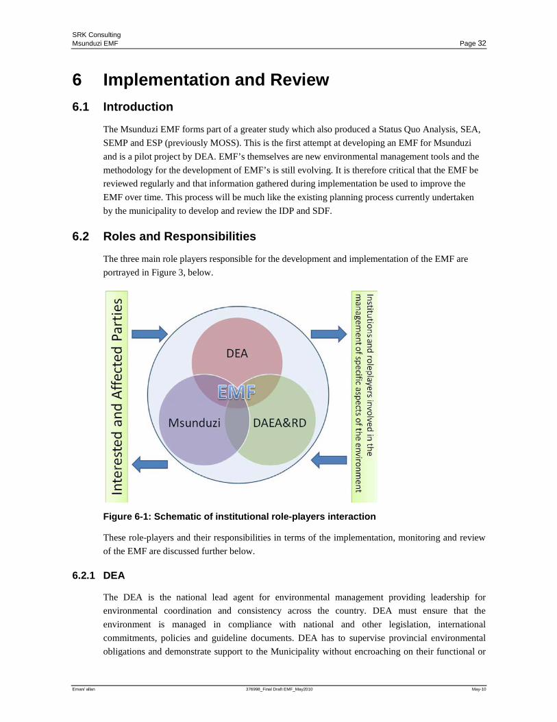
SRK Consulting Msunduzi EMF Page 32
Eman/ allan 376998_Final Draft EMF_May2010 May-10
6 Implementation and Review 6.1 Introduction
The Msunduzi EMF forms part of a greater study which also produced a Status Quo Analysis, SEA,
SEMP and ESP (previously MOSS). This is the first attempt at developing an EMF for Msunduzi
and is a pilot project by DEA. EMF’s themselves are new environmental management tools and the
methodology for the development of EMF’s is still evolving. It is therefore critical that the EMF be
reviewed regularly and that information gathered during implementation be used to improve the
EMF over time. This process will be much like the existing planning process currently undertaken
by the municipality to develop and review the IDP and SDF.
6.2 Roles and Responsibilities
The three main role players responsible for the development and implementation of the EMF are
portrayed in Figure 3, below.
Figure 6-1: Schematic of institutional role-players interaction
These role-players and their responsibilities in terms of the implementation, monitoring and review
of the EMF are discussed further below.
6.2.1 DEA
The DEA is the national lead agent for environmental management providing leadership for
environmental coordination and consistency across the country. DEA must ensure that the
environment is managed in compliance with national and other legislation, international
commitments, policies and guideline documents. DEA has to supervise provincial environmental
obligations and demonstrate support to the Municipality without encroaching on their functional or
SRK Consulting Msunduzi EMF Page 33
Eman/ allan 376998_Final Draft EMF_May2010 May-10
institutional integrity. DEA is a key governance partner of the Msunduzi Municipality and this has
been demonstrated through the funding of the development of the EMF.
To further meet their responsibilities it is envisaged that DEA will continue to provide support for
the review of the EMF.
6.2.2 DAEA&RD
The DAEA&RD, as the provincial lead agent for environmental management, shares its powers with
national government. They are responsible for implementing national legislation, most notably the
NEMA EIA Regulations, and have the functional powers to prepare provincial legislation in specific
areas and must cooperate with other spheres of government. Acting on behalf of the inhabitants of
the province they must ensure that the Municipality exercises good environmental governance. They
therefore have to support, monitor and develop local government’s capacity to enable it to perform
its environmental functions and to ensure that service delivery is environmentally sound.
DAEA&RD is a key governance partner of the Msunduzi Municipality and has supported the
development of the EMF.
Once the EMF has been gazetted the DAEA&RD will be legally bound to consider the Msunduzi
EMF as part of the environmental authorisation process.
As part of the implementation process developers and applicants will need to access the EMF,
specifically the mapping and GIS reporting function. It is anticipated that DAEA&RD, through its
Environmental Impacts Assessment and Environmental Planning services, will make the EMF
available to the public.
6.2.3 Msunduzi Municipality
The Local Municipality’s role as facilitator in environmental governance stands at the forefront of
the EMF. Msunduzi must provide its environmental management functions such as storm water
management, water and sanitation services and refuse removal as well as promoting environmental
governance in its area. The Municipality must also monitor environmental compliance through its
building inspectorate and must ensure environmental compliance when providing basic services.
Msunduzi will be the main roleplayer in the implementation and review of the EMF. Msunduzi will
need to make the EMF available to the public and will be responsible for the review of the EMF. As
stated above it is envisaged however that DEA and DAEA&RD will assist Msunduzi by providing
support for the review process. As part of the EMF review process the spatial data (GIS datasets)
will need to be regularly updated by Msunduzi using information from site specific investigations
such as EIA’s or as a result of changes in land use. It is recommended that the Msunduzi C-Plan be
updated every 6 months to a year and EKZNW has offered to assist with this.
The EMF, while supplying site specific information on environmental constraints, should also be
used in planning and for the identification of suitable sites for specific developments. Msunduzi will
need to ensure that the EMF is considered during future reviews of the SDF and the development of
the Land Use Management System.
SRK Consulting Msunduzi EMF Page 34
Eman/ allan 376998_Final Draft EMF_May2010 May-10
6.3 Capacity, Training and Awareness
The EMF is a culmination of a wide range of spatial data, legal requirements and guidelines which
together comprise a complex system. Whilst this information is generally available in hard copy
format, the anticipated future benefits will be derived from being able to interact with the data via a
computer interface best provided by a GIS system to inform specific decisions.
In order to do this effectively the users will need to be adequately proficient in using the systems.
The organisations referred to above will also need to provide suitable infrastructure to support the
use, both with the current system and with managing, maintaining and developing future systems.
The user interface for the Msunduzi EMF has been designed using ArcGIS 9.3 software.
While the shapefiles produced may be used with any GIS software, ARCGIS 9.3 will be required to
access the report function that forms the basis of the user interface. It is therefore strongly
recommended that all organisations, (DAEA&RD and Msunduzi) that will need to access the
reporting function and make it available to the public, have access to ArcGIS 9.3.
The training as referred to above will be sufficient to enable the user to produce and understand
reports. In order to use the data to inform planning and identify potential sites using queries the user
will require a sound understanding of GIS and the use of layers and queries will be required. Specific
training on the Msunduzi EMF will not be required to enable the user to access this functionality as
this is part of the standard ArcGIS 9.3 software and is not part of the user interface software.
6.4 Documentation and Record Keeping
As above the reports and data will be held by DAEA&RD and Msunduzi who will make the
Msunduzi EMF available to the public. It is anticipated that DAEA&RD will make the information
available through their existing EIA structures at the District level. Msunduzi will make the
information available through their Development Services Conservation & Environment Sub-Unit in
response to development applications and queries.
It is suggested that in addition to the continual update of the EMF data, as discussed below, the
Msunduzi EMF should follow a formal review process every 5 years. The review should use the
updated data to:
• Inform the preparation of review reports;
• Update the desired state of the environment based on a public participation process;
• Amend the management priorities and desirable and undesirable activities in terms of the
environmental management zones.
While DAEA&RD will hold the data only, Msunduzi will be responsible for updating the data and
reviewing the EMF. It is therefore critical that Msunduzi supply any updated datasets to
DAEA&RD. To assist with EMF data upkeep during implementation the following process for the
upkeep of data has been provided.
SRK Consulting Msunduzi EMF Page 35
Eman/ allan 376998_Final Draft EMF_May2010 May-10
6.4.1 Data Upkeep
As with all information, over time features will change. When this change happens, the data
contained within the GIS information will need to be updated. In order for these updates to occur a
number of mechanisms must be kept in place. These mechanisms are:
Formalised data management structure must be carefully considered to include:
• the protocols for managing the data related to the EMF,
• the controls for incoming data,
• the procedures for updating,
• the definition of roles and responsibilities and
• ensuring that adequate capacity is provided
• Naming conventions – it is imperative that all naming conventions for files, fields and attribute
information are kept consistent with the original datasets. When replacing older information with
newer information, the naming conventions used in the old dataset must remain unchanged. This
is due to the way that the GIS software refers to the information within the system;
• Experience – the GIS user must have at least some understanding of how the GIS software
operates; and
• Data Quality – the data used in the update must be of high quality. If the data quality of the
update is compromised, the final output of the GIS tool will be poor.
Data management has become a growing issue in the implementation of the EMF. DEA has
recognised that there is a need to provide national norms and standards for the management and
sharing of EMF information. There are, however, differing capacities within municipalities and
therefore there is a need to develop local protocols in dealing with environmental information. It has
been recommended that to assist in the development of these protocols a data management task team
to consist of Msunduzi, DAEA&RD, DEA and EKZNW be established.
SRK Consulting Msunduzi EMF Page 36
Eman/ allan 376998_Final Draft EMF_May2010 May-10
7 Public Involvement An extensive public consultation process was undertaken to support the preparation of the EMF. This included an initial planning workshop with key stakeholders,
two public meetings to discuss the desired state of environment and the Draft EMF Report, notices to IAP’s and newspaper advertisements.
SRK, in partnership with Msunduzi Municipality Environmental Branch, made every effort to ensure that the EMF was informed by public input and that a wide
range of public sectors gained access to the documentation and participated in the process.
A detailed account of the public consultation process, together with all notices, representations received, notices issued and a copy of the IAP database, is included in
the Public Consultation Record which has been produced as a separate document as it relates to all the products produced in terms of the Greater Msunduzi EMF
project. In addition to the public involvement undertaken during the preparation of the EMF the Final draft of the EMF will be presented to the Msunduzi portfolio
committees and thereafter to the Executive Committee for adoption. At that stage the DAEA&RD will then initiate the process to gazette the EMF through the office
of the MEC
Table 3.1 includes all comments received in the Draft ESP Report during public consultation and associated responses.
Table 7.1: Comments received in the SEA and associated Responses
Date Individual Company / Organisation
Comment / Issue / Concern Response
EMF
18 March 2010 Public Meeting
Ms. T Collocott Private Industry such as a recycling plant may be achieving certain objectives it still poses significant impacts to the environment.
Msunduzi requires additional capacity to address on-site impacts and environmental issues. To address capacity constraints Action Plan G1 Environmental Capacity Assessment has been recommended.
18 March 2010 Public Meeting
Ms. M. Ngotho GREEN Queried the public consultation process and asked that it be detailed in the EMF Report.
The EMF public consultation process had built on the existing framework that was developed as part of the process to develop an Integrated Environmental Management Policy. The process has been extensive and is documented in Section 7 of the EMF Report.
SRK Consulting Msunduzi EMF Page 37
Eman/ allan 376998_Final Draft EMF_May2010 May-10
Date Individual Company / Organisation
Comment / Issue / Concern Response
18 March 2010 Public Meeting
Ms. P. Long PMMB Trust To what extent have linkages been addressed in the EMF and ESP.
Linkages have not been included as part of the EMF user interface but the ESP included the identification of links to maintain biodiversity and the EMF Mapping allows the investigation of linkages by officials.
18 March 2010 Public Meeting
Ms. S. Schutte Upper Mpushini Conservancy
What are the management priorities for areas of development constraint in terms of the biodiversity layer? No industry should be permitted in these areas. Is it possible to submit additional information to inform the C-Plan process?
Prior to development of biodiversity constraint areas (yellow areas) it is recommended that a site specific biodiversity assessment be undertaken. The land use recommendations have been amended. Any additional information regarding biodiversity distribution should be submitted to Msunduzi and will inform the review of the C-Plan as part of the EMF review.
18 March 2010 Public Meeting
Ms. S. Schutte Upper Mpushini Conservancy
The definition of agricultural land use should be amended to refer specifically to cultivation.
Given the comments received from IAP’s it was decided that the approach should focus more on impact than land use and that land use definitions and preferred and non-preferred land use should rather be addressed by the LUMS. The definitions of different land use types have therefore been removed from the EMF. It is believed that this will reduce confusion during implementation of the EMF and reduce the risk of misinterpretation.
25 March 2010 Written Comments
Ms. S. Schutte Upper Mpushini Conservancy
A number of changes to the preferred and Non preferred land uses in terms of the EMF are provided.
In light of these comments the approach to recommendations for land use in conservation zones has been amended. This is reflected in the amended EMF Report.
18 March 2010 Public Meeting
Cllr. S. Lyne Msunduzi Municipality: Ward Councilor
How will illegal development be prevented and compliance ensured?
The SEMP includes Action Plan G1 Environmental Capacity Assessment to improve environmental capacity within Msunduzi.
18 March 2010 Public Meeting
Mr. L. Ngobo Greater Edendale Development Initiative (GEDI)
The use of preferred and non preferred land use should be more carefully explained.
In light of these comments the approach to recommendations for land use in conservation zones has been amended. This is reflected in the amended EMF Report.
25 March 2010 Written Comments
Mr. N. Durow Lower Mpushini Conservancy
The definition of low density residential that is given on page 20 is incomplete. In terms of the definition given, for example, a development in which erf sizes are 300m2 would be considered low density even if each erf had a house of 200m2 on it and an outbuilding of 75m2. This would hardly be low-density. The definition should be amended to include a minimum erf (plot) size and a maximum ground coverage occupied by the buildings.
Given the comments received from IAP’s it was decided that the approach should focus more on impact than land use and that land use definitions and preferred and non-preferred land use should rather be addressed by the LUMS. The definitions of different land use types have therefore been removed from the EMF. It is believed that this will reduce confusion during implementation of the EMF and reduce the risk of misinterpretation.
SRK Consulting Msunduzi EMF Page 38
Eman/ allan 376998_Final Draft EMF_May2010 May-10
Date Individual Company / Organisation
Comment / Issue / Concern Response
25 March 2010 Written Comments
Mr. N. Durow Lower Mpushini Conservancy
The definition given of open space states: “These areas may include buffer areas between developments and animal preserve areas. ” Here I would be happier if the word “animal” were replaced by the term “wildlife” or “nature”. Areas set aside for the preservation of wildlife or nature are not necessarilly there only for the preservation of animals. They may be established for the preservation of plants, or birds, or certain invertebrate species.
Given the comments received from IAP’s it was decided that the approach should focus more on impact than land use and that land use definitions and preferred and non-preferred land use should rather be addressed by the LUMS. The definitions of different land use types have therefore been removed from the EMF. It is believed that this will reduce confusion during implementation of the EMF and reduce the risk of misinterpretation.
25 March 2010 Written Comments
Mr. N. Durow Lower Mpushini Conservancy
The report states that the wetland buffer areas should have a buffer of 20m. If river courses are taken as being wetlands the buffer should be 60m on either side of the river bank ( as per page 137 of the Msunduzi SDF): “DAEA recommends 60m on either side of the river (120m). These buffers are already shown on the map.” It is important that these widths are specified in the EMF so that there can be no ambiguity when it comes to EIA or DFA applications from developers.
Noted the management priorities have been amended in the report.
25 March 2010 Written Comments
Neville Durow Lower Mpushini Conservancy
Biodiversity Development Constraint Area : Light industry should be Non Preferred Identified Water Quality Areas - all industries should be omitted from the preferred land uses in natural areas. Any industry, no matter how “clean” its is made out to be is likely at some stage or other to have oil or other pollutant leaks and these can irreparably damage natural water systems. I did a search of the internet and discovered that, where planning documents mentioned water quality, the conservation or improvement of water quality was a primary aim in property developments. Most planning bodies stressed that natural, unpolluted drainage systems were to be maintained at all costs and that no industrial developments were to be allowed in these areas. These areas were to be exclusively reserved for recreation, nature conseravtion and eco-tourism. The same should be true for the Msunduzi Municipality (and all other municipalities).
In light of these comments the approach to recommendations for land use in conservation zones has been amended. This is reflected in the amended EMF Report.
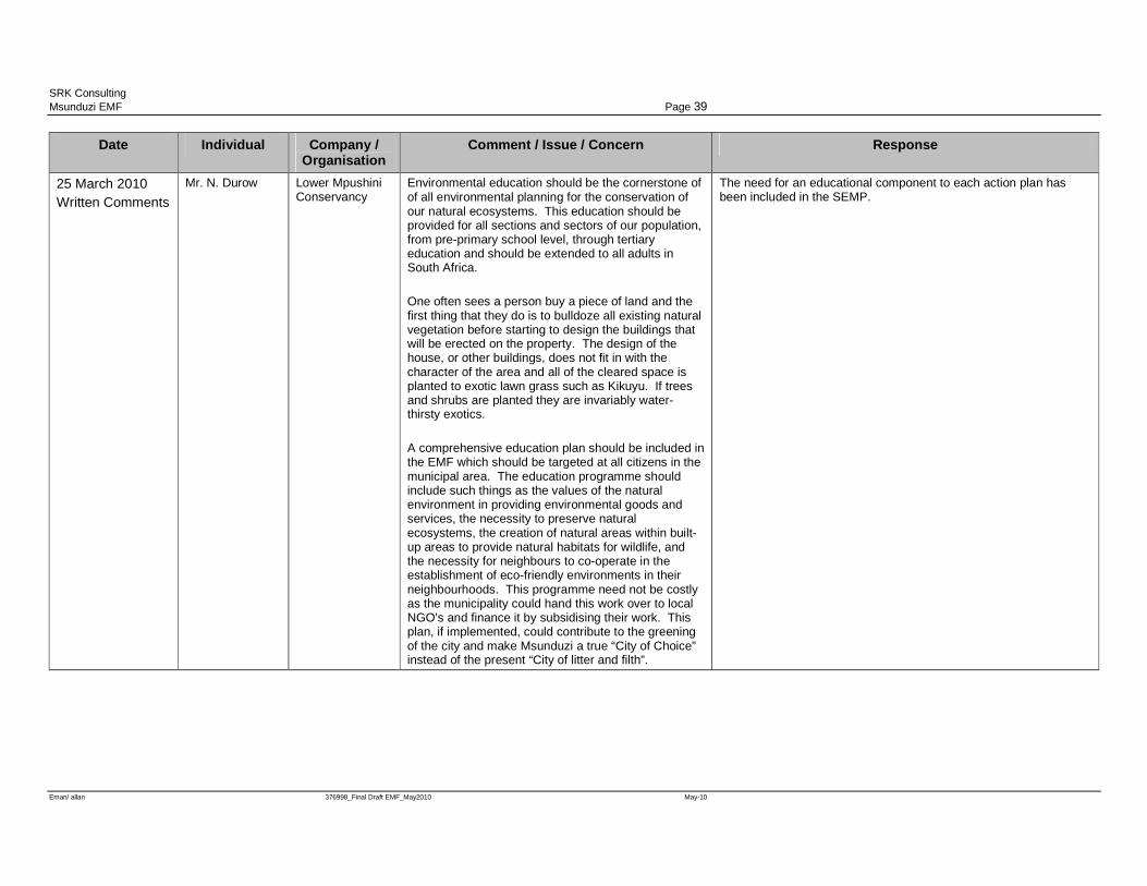
SRK Consulting Msunduzi EMF Page 39
Eman/ allan 376998_Final Draft EMF_May2010 May-10
Date Individual Company / Organisation
Comment / Issue / Concern Response
25 March 2010 Written Comments
Mr. N. Durow Lower Mpushini Conservancy
Environmental education should be the cornerstone of of all environmental planning for the conservation of our natural ecosystems. This education should be provided for all sections and sectors of our population, from pre-primary school level, through tertiary education and should be extended to all adults in South Africa. One often sees a person buy a piece of land and the first thing that they do is to bulldoze all existing natural vegetation before starting to design the buildings that will be erected on the property. The design of the house, or other buildings, does not fit in with the character of the area and all of the cleared space is planted to exotic lawn grass such as Kikuyu. If trees and shrubs are planted they are invariably water-thirsty exotics. A comprehensive education plan should be included in the EMF which should be targeted at all citizens in the municipal area. The education programme should include such things as the values of the natural environment in providing environmental goods and services, the necessity to preserve natural ecosystems, the creation of natural areas within built-up areas to provide natural habitats for wildlife, and the necessity for neighbours to co-operate in the establishment of eco-friendly environments in their neighbourhoods. This programme need not be costly as the municipality could hand this work over to local NGO's and finance it by subsidising their work. This plan, if implemented, could contribute to the greening of the city and make Msunduzi a true “City of Choice” instead of the present “City of litter and filth”.
The need for an educational component to each action plan has been included in the SEMP.
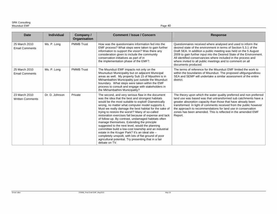
SRK Consulting Msunduzi EMF Page 40
Eman/ allan 376998_Final Draft EMF_May2010 May-10
Date Individual Company / Organisation
Comment / Issue / Concern Response
25 March 2010 Email Comments
Ms. P. Long PMMB Trust How was the questionnaire information fed into the EMF process? What steps were taken to gain further information to support the vision? Was there any consideration given to include the community conservation initiatives as part of in the implementation phase of the EMF?.
Questionnaires received where analysed and used to inform the desired state of the environment in terms of Section 5.3.1 of the Draft SEA. In addition a public meeting was held on the 5 August 2009 to gain further input into the Desired State of the Environment. All identified conservancies where included in the process and where invited to all public meetings and to comment on all documents produced.
25 March 2010 Email Comments
Ms. P. Long PMMB Trust The Msunduzi EMF impacts not only on the Msunuduzi Municipality but on adjacent Municipal areas as well. My property Sub 15 of Mpushini is in Mkhambathini Municipality just outside the Msunduzi boundary. What steps were taken within the EMF process to consult and engage with stakeholders in the Mkhambathini Municipality?
The terms of reference for the Msunduzi EMF limited the work to within the boundaries of Msunduzi. The proposed uMgungundlovu SEA and SEMP will undertake a similar assessment of the entire district.
23 March 2010 Written Comments
Dr. D. Johnson Private The second, and very serious flaw in the document was the idea that the best and strongest habitats would be the most suitable to exploit! Diametrically wrong, no matter what computer model supports it. Must we really damage the best habitat for the sake of trying to restore the worst!? Many of so-called restoration exercises fail because of expense and lack of follow-up. By contrast, undamaged habitats often manage themselves. Extending the principle suggested to the next level, would the planning committee build a low-cost township and an industrial estate in the Kruger Park? It’s an ideal site – completely unspoilt, with lots of flat ground of poor agricultural potential. Try presenting that in a fair debate on TV.
The theory upon which the water quality preferred and non preferred land use was based was that untransformed sub catchments have a greater absorption capacity than those that have already been transformed. In light of comments received from the public however the approach to recommendations for land use in conservation zones has been amended. This is reflected in the amended EMF Report.
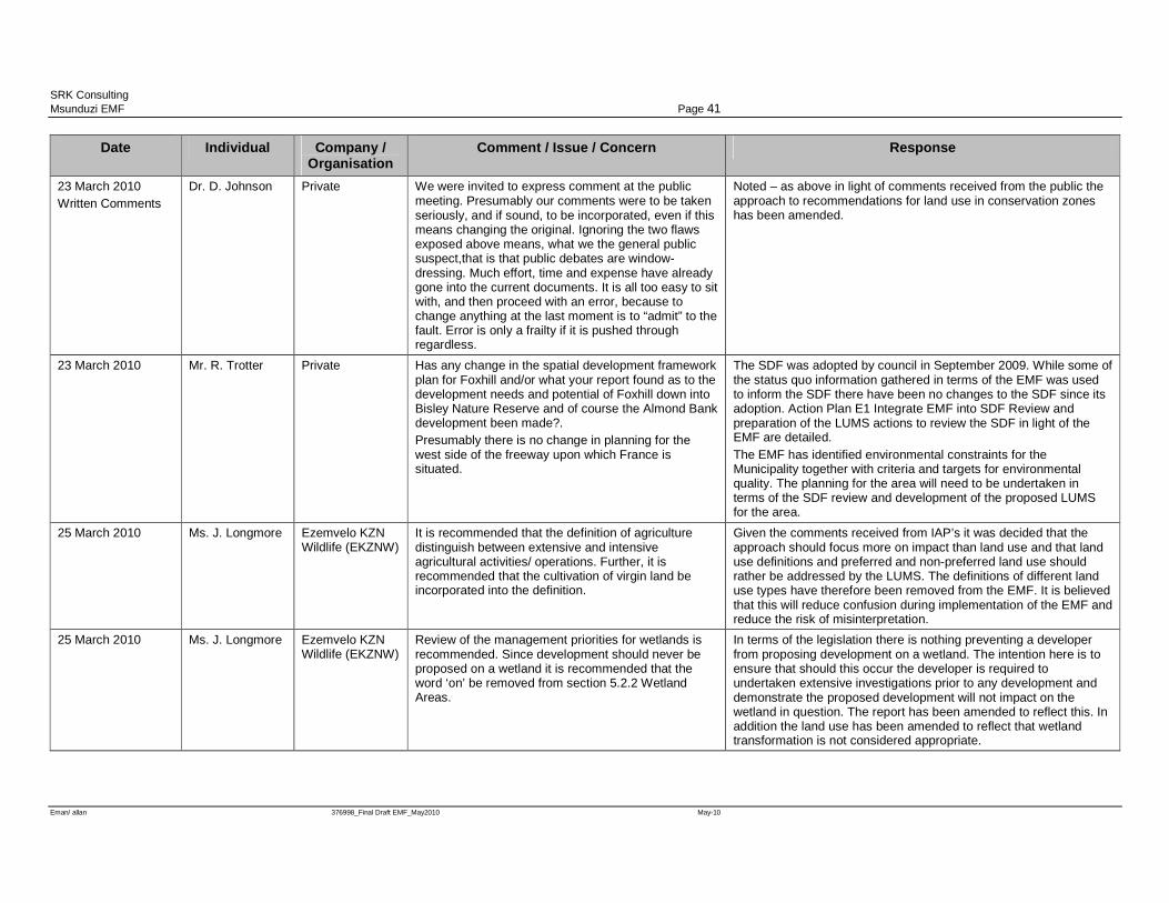
SRK Consulting Msunduzi EMF Page 41
Eman/ allan 376998_Final Draft EMF_May2010 May-10
Date Individual Company / Organisation
Comment / Issue / Concern Response
23 March 2010 Written Comments
Dr. D. Johnson Private We were invited to express comment at the public meeting. Presumably our comments were to be taken seriously, and if sound, to be incorporated, even if this means changing the original. Ignoring the two flaws exposed above means, what we the general public suspect,that is that public debates are window-dressing. Much effort, time and expense have already gone into the current documents. It is all too easy to sit with, and then proceed with an error, because to change anything at the last moment is to “admit” to the fault. Error is only a frailty if it is pushed through regardless.
Noted – as above in light of comments received from the public the approach to recommendations for land use in conservation zones has been amended.
23 March 2010 Mr. R. Trotter Private Has any change in the spatial development framework plan for Foxhill and/or what your report found as to the development needs and potential of Foxhill down into Bisley Nature Reserve and of course the Almond Bank development been made?. Presumably there is no change in planning for the west side of the freeway upon which France is situated.
The SDF was adopted by council in September 2009. While some of the status quo information gathered in terms of the EMF was used to inform the SDF there have been no changes to the SDF since its adoption. Action Plan E1 Integrate EMF into SDF Review and preparation of the LUMS actions to review the SDF in light of the EMF are detailed. The EMF has identified environmental constraints for the Municipality together with criteria and targets for environmental quality. The planning for the area will need to be undertaken in terms of the SDF review and development of the proposed LUMS for the area.
25 March 2010 Ms. J. Longmore Ezemvelo KZN Wildlife (EKZNW)
It is recommended that the definition of agriculture distinguish between extensive and intensive agricultural activities/ operations. Further, it is recommended that the cultivation of virgin land be incorporated into the definition.
Given the comments received from IAP’s it was decided that the approach should focus more on impact than land use and that land use definitions and preferred and non-preferred land use should rather be addressed by the LUMS. The definitions of different land use types have therefore been removed from the EMF. It is believed that this will reduce confusion during implementation of the EMF and reduce the risk of misinterpretation.
25 March 2010 Ms. J. Longmore Ezemvelo KZN Wildlife (EKZNW)
Review of the management priorities for wetlands is recommended. Since development should never be proposed on a wetland it is recommended that the word ‘on’ be removed from section 5.2.2 Wetland Areas.
In terms of the legislation there is nothing preventing a developer from proposing development on a wetland. The intention here is to ensure that should this occur the developer is required to undertaken extensive investigations prior to any development and demonstrate the proposed development will not impact on the wetland in question. The report has been amended to reflect this. In addition the land use has been amended to reflect that wetland transformation is not considered appropriate.
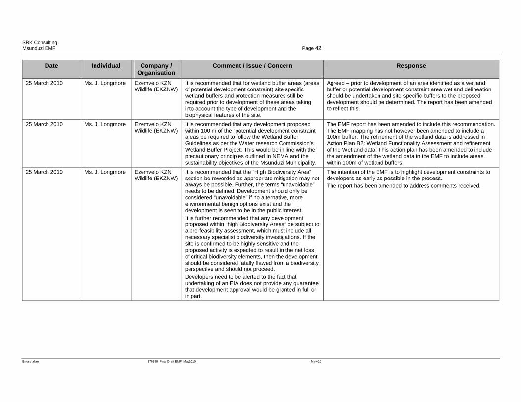
SRK Consulting Msunduzi EMF Page 42
Eman/ allan 376998_Final Draft EMF_May2010 May-10
Date Individual Company / Organisation
Comment / Issue / Concern Response
25 March 2010 Ms. J. Longmore Ezemvelo KZN Wildlife (EKZNW)
It is recommended that for wetland buffer areas (areas of potential development constraint) site specific wetland buffers and protection measures still be required prior to development of these areas taking into account the type of development and the biophysical features of the site.
Agreed – prior to development of an area identified as a wetland buffer or potential development constraint area wetland delineation should be undertaken and site specific buffers to the proposed development should be determined. The report has been amended to reflect this.
25 March 2010 Ms. J. Longmore Ezemvelo KZN Wildlife (EKZNW)
It is recommended that any development proposed within 100 m of the “potential development constraint areas be required to follow the Wetland Buffer Guidelines as per the Water research Commission’s Wetland Buffer Project. This would be in line with the precautionary principles outlined in NEMA and the sustainability objectives of the Msunduzi Municipality.
The EMF report has been amended to include this recommendation. The EMF mapping has not however been amended to include a 100m buffer. The refinement of the wetland data is addressed in Action Plan B2: Wetland Functionality Assessment and refinement of the Wetland data. This action plan has been amended to include the amendment of the wetland data in the EMF to include areas within 100m of wetland buffers.
25 March 2010 Ms. J. Longmore Ezemvelo KZN Wildlife (EKZNW)
It is recommended that the “High Biodiversity Area” section be reworded as appropriate mitigation may not always be possible. Further, the terms “unavoidable” needs to be defined. Development should only be considered “unavoidable” if no alternative, more environmental benign options exist and the development is seen to be in the public interest. It is further recommended that any development proposed within “high Biodiversity Areas” be subject to a pre-feasibility assessment, which must include all necessary specialist biodiversity investigations. If the site is confirmed to be highly sensitive and the proposed activity is expected to result in the net loss of critical biodiversity elements, then the development should be considered fatally flawed from a biodiversity perspective and should not proceed. Developers need to be alerted to the fact that undertaking of an EIA does not provide any guarantee that development approval would be granted in full or in part.
The intention of the EMF is to highlight development constraints to developers as early as possible in the process. The report has been amended to address comments received.
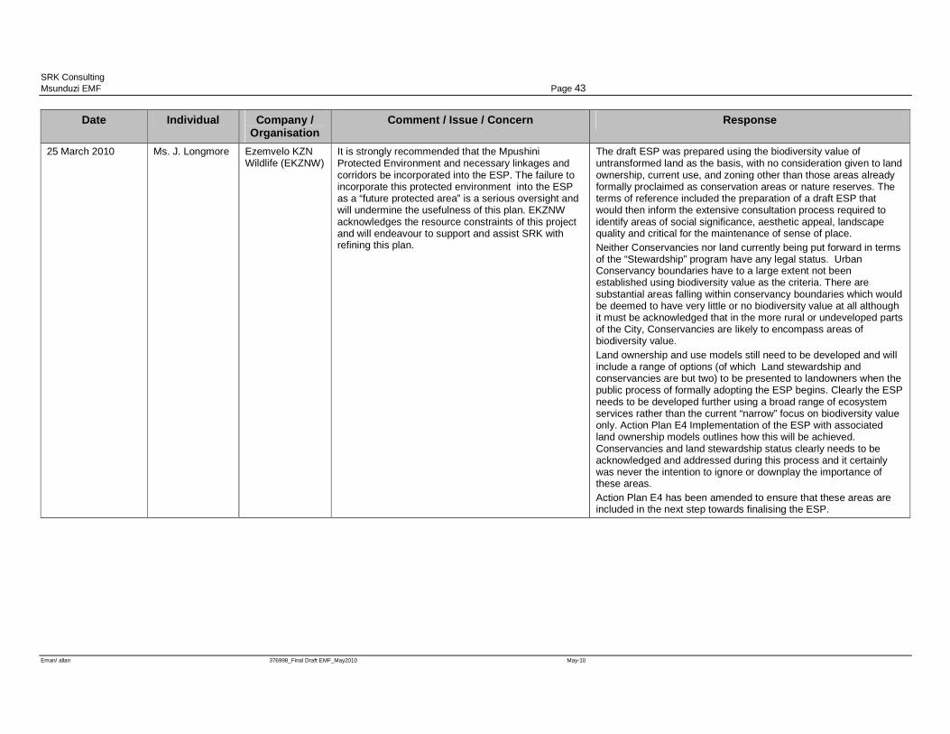
SRK Consulting Msunduzi EMF Page 43
Eman/ allan 376998_Final Draft EMF_May2010 May-10
Date Individual Company / Organisation
Comment / Issue / Concern Response
25 March 2010 Ms. J. Longmore Ezemvelo KZN Wildlife (EKZNW)
It is strongly recommended that the Mpushini Protected Environment and necessary linkages and corridors be incorporated into the ESP. The failure to incorporate this protected environment into the ESP as a “future protected area” is a serious oversight and will undermine the usefulness of this plan. EKZNW acknowledges the resource constraints of this project and will endeavour to support and assist SRK with refining this plan.
The draft ESP was prepared using the biodiversity value of untransformed land as the basis, with no consideration given to land ownership, current use, and zoning other than those areas already formally proclaimed as conservation areas or nature reserves. The terms of reference included the preparation of a draft ESP that would then inform the extensive consultation process required to identify areas of social significance, aesthetic appeal, landscape quality and critical for the maintenance of sense of place. Neither Conservancies nor land currently being put forward in terms of the “Stewardship” program have any legal status. Urban Conservancy boundaries have to a large extent not been established using biodiversity value as the criteria. There are substantial areas falling within conservancy boundaries which would be deemed to have very little or no biodiversity value at all although it must be acknowledged that in the more rural or undeveloped parts of the City, Conservancies are likely to encompass areas of biodiversity value. Land ownership and use models still need to be developed and will include a range of options (of which Land stewardship and conservancies are but two) to be presented to landowners when the public process of formally adopting the ESP begins. Clearly the ESP needs to be developed further using a broad range of ecosystem services rather than the current “narrow” focus on biodiversity value only. Action Plan E4 Implementation of the ESP with associated land ownership models outlines how this will be achieved. Conservancies and land stewardship status clearly needs to be acknowledged and addressed during this process and it certainly was never the intention to ignore or downplay the importance of these areas. Action Plan E4 has been amended to ensure that these areas are included in the next step towards finalising the ESP.
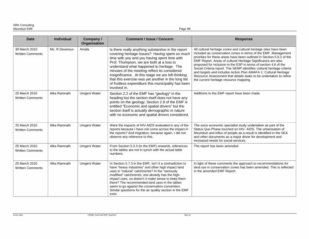
SRK Consulting Msunduzi EMF Page 44
Eman/ allan 376998_Final Draft EMF_May2010 May-10
Date Individual Company / Organisation
Comment / Issue / Concern Response
30 March 2010 Written Comments
Ms. R Devereux Amafa Is there really anything substantive in the report covering heritage issues? Having spent so much time with you and you having spent time with Prof. Thompson, we are both at a loss to understand what happened to heritage. The minutes of the meeting reflect its considered insignificance. At this stage we are left thinking that this exercise was yet another in the long list of fruitless expenditure this municipality has been involved in.
All cultural heritage zones and cultural heritage sites have been included as conservation zones in terms of the EMF. Management priorities for these areas have been outlined in Section 5.9.2 of the EMF Report. Areas of cultural Heritage Significance are also proposed for inclusion in the ESP in terms of section 4.6 of the Social Criteria report. The SEMP identifies cultural heritage criteria and targets and includes Action Plan AMAFA 1: Cultural Heritage Resource Assessment that details tasks to be undertaken to refine the current heritage resource mapping.
25 March 2010 Written Comments
Alka Ramnath Umgeni Water Section 2.2 of the EMF has “geology” in the heading but the section itself does not have any points on the geology. Section 2.8 of the EMF is entitled “Economic and spatial drivers” but the section itself is actually demographic in nature with no economic and spatial drivers considered.
Additions to the EMF report have been made.
25 March 2010 Written Comments
Alka Ramnath Umgeni Water Were the impacts of HIV-AIDS evaluated in any of the reports because I have not come across the impact in the reports? And migration, because again, I did not observe any reference to this.
The socio economic specialist study undertaken as part of the Status Quo Phase touched on HIV- AIDS. The urbanisation of Msunduzi and influx of people as a result is identified in the SEA and other documents as a major driver for development and increased needs for social services.
25 March 2010 Written Comments
Alka Ramnath Umgeni Water From Section 5.3.3 (in the EMF) onwards, references to the tables are not in synch with the actual table numbers.
The report has been amended
25 March 2010 Written Comments
Alka Ramnath Umgeni Water In Section 5.7.3 in the EMF, isn’t it a contradiction to have “heavy industries” and other high impact land uses in “natural” catchments? In the “seriously modified” catchments, one already has the high-impact uses, so doesn’t it make sense to keep them there? The recommended land uses in the tables seem to go against the conservation convention. Similar questions for the air quality section in the EMF exist.
In light of these comments the approach to recommendations for land use in conservation zones has been amended. This is reflected in the amended EMF Report.
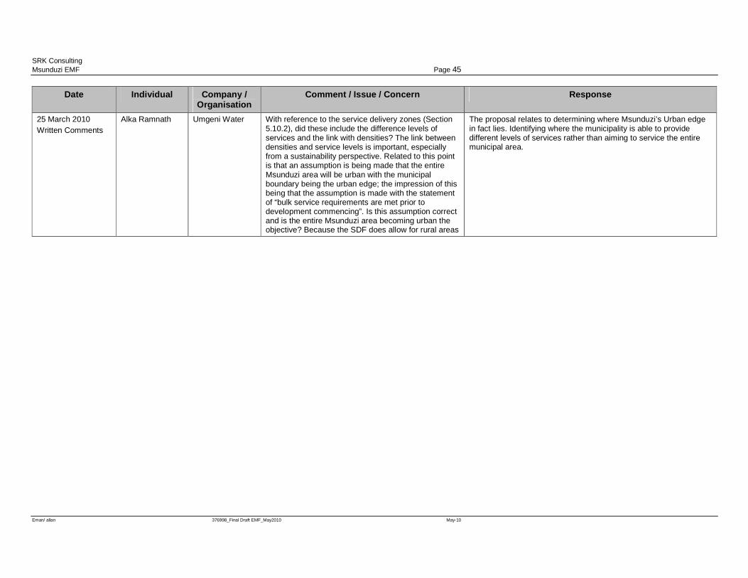
SRK Consulting Msunduzi EMF Page 45
Eman/ allan 376998_Final Draft EMF_May2010 May-10
Date Individual Company / Organisation
Comment / Issue / Concern Response
25 March 2010 Written Comments
Alka Ramnath Umgeni Water With reference to the service delivery zones (Section 5.10.2), did these include the difference levels of services and the link with densities? The link between densities and service levels is important, especially from a sustainability perspective. Related to this point is that an assumption is being made that the entire Msunduzi area will be urban with the municipal boundary being the urban edge; the impression of this being that the assumption is made with the statement of “bulk service requirements are met prior to development commencing”. Is this assumption correct and is the entire Msunduzi area becoming urban the objective? Because the SDF does allow for rural areas
The proposal relates to determining where Msunduzi’s Urban edge in fact lies. Identifying where the municipality is able to provide different levels of services rather than aiming to service the entire municipal area.
SRK Consulting Msunduzi EMF Page 46
Eman/ allan 376998_Final Draft EMF_May2010 May-10
8 Conclusion The EMF is a strategic document and as such cannot assess the impact of project level issues.
However, the EMF aims to identify areas both suitable and unsuitable for development and provides
information to assist decision making. The EMF does not prohibit the submission of any
development applications, rather the EMF will inform decision making when such development
applications are received. The EMF has been designed in terms of the NEMA Principles (Chapter 1
Section 2) and specifically in accordance with the precautionary principle:-
“ that a risk-averse and cautious approach is applied, which takes into account the limits of current
knowledge about the consequences of decisions and actions”
As such the EMF has included all areas of potential conservation significance within the
environmental management zones. The intention is to identify the need for further investigation in
areas where the need for conservation has been identified or is unknown.
The EMF is a living document and as this is the first strategic environmental planning tool to be
developed for Msunduzi it is likely that through implementation a number of changes will be
identified. As more detailed information becomes available mapping should be updated and the
accuracy will therefore improve. It is therefore critical that the EMF be perceived as a living
document that should grow and evolve with the municipality.
SRK Consulting Msunduzi EMF Page 47
Eman/ allan 376998_Final Draft EMF_May2010 May-10
9 References Department of Agriculture and Environmental Affairs, Environmental toolkit -Section 3 Tools –
Policy and Legislative Overview (Unpublished report, date unknown);
DEA (2007), Strategic Environmental Assessment Guideline, Integrated Environmental Guideline
Series 4, Department of Environmental Affairs and Tourism (DEA), Pretoria, South Africa
Environment Conservation Act, No. 73 of 1989
Institute of Natural Resources, Agriculture specialist study conducted as part of the Msunduzi
Environmental Management Framework, (Unpublished report, 2009)
Institute of Natural Resources, Biodiversity specialist study conducted as part of the Msunduzi
Environmental Management Framework, (Unpublished report, 2008)
Institute of Natural Resources, Surface Water specialist study conducted as part of the Msunduzi
Environmental Management Framework, (Unpublished report, 2008)
Institute of Natural Resources, Wetlands specialist study conducted as part of the Msunduzi
Environmental Management Framework, (Unpublished report, 2008)
Isibuko Se Afrika, Socio-economic analysis and planning policy review specialist study conducted
as part of the Msunduzi Environmental Management Framework, (Unpublished report, 2009)
Local Government Municipal Structures Act 117 of 1998
Msunduzi Municipality, Msunduzi Integrated Development Plan for 2008 to 2012 (Msunduzi
Municipality 2008)
Msunduzi Municipality, Msunduzi Spatial Development Framework (Msunduzi Municipality 2009)
Municipal Planning and Performance Management Regulations (2001)
Municipal Systems Act 32 of 1998
National Environmental Management Act, No. 107 of 1998
National Environmental Management Act, Environmental Impact Assessment Regulations (GNR
385, GNR 386 and GNR 387, 2006)
Republic of South Africa Constitution Act 110 of 1983
SRK Consulting, Catchment Hydrology specialist study conducted as part of the Msunduzi
Environmental Management Framework, (Unpublished report, 2009)
SRK Consulting, Cultural heritage specialist study conducted as part of the Msunduzi Environmental
Management Framework, (Unpublished report, 2008)
SRK Consulting Msunduzi EMF Page 48
Eman/ allan 376998_Final Draft EMF_May2010 May-10
SRK Consulting, Current service capacity specialist study conducted as part of the Msunduzi
Environmental Management Framework, (Unpublished report, 2009)
SRK Consulting, Institutional Analysis conducted as part of the Msunduzi Environmental
Management Framework, (Unpublished report, 2009)
WSP Environmental, Air quality specialist study conducted as part of the Msunduzi Environmental
Management Framework, (Unpublished report, 2009)

SRK Consulting Msunduzi EMF Page 49
Eman/ allan 376998_Final Draft EMF_May2010 May-10
Appendices Appendix 1 Maps

SRK Consulting Msunduzi EMF Page 50
Eman/ allan 376998_Final Draft EMF_May2010 May-10
Appendix 2 Listed Activities in terms of the NEMA EIA Regulations

Listed Activities in Terms of the NEMA EIA Regulations
The table below indicates activities that may be triggered by development in each of the environmental management zones.
Conservation Zone Trigger Explanation
Wetland areas
NEMA – GNR 386 (1t) The construction of facilities or infrastructure, including associated structures or infrastructure, for marinas and the launching of watercraft on inland fresh water systems.
NEMA – GNR 386 (4) The dredging, excavation, infilling, removal or moving of soil, sand or rock exceeding 5 cubic metres from a river, tidal lagoon, tidal river, lake, in-stream dam, floodplain or wetland.
NEMA – GNR 387 (6) The construction of a dam where the highest part of the dam wall, as measured from the outside toe of the wall to the highest part of the wall, is 5 metres or higher or where the high-water mark of the dam covers an area of 10 hectares or more.
Areas of Biodiversity importance
NEMA – GNR 386 (1d) The construction of facilities or infrastructure, including associated structures or infrastructure, for resorts, lodges, hotels or other tourism and hospitality facilities in a protected area contemplated in the National Environmental Management: Protected Areas Act, 2003 (Act No. 57 of 2003).
NEMA – GNR 386 (1e) The construction of facilities or infrastructure, including associated structures or infrastructure, for any purpose where lawns, playing fields or sports tracks covering an area of more than three hectares, but less than 10 hectares, will be established.
NEMA – GNR 386 (1f) The construction of facilities or infrastructure, including associated structures or infrastructure, for sport spectator facilities with the capacity to hold 8 000 spectators or more.
NEMA – GNR 386 (1h-i) The construction of facilities or infrastructure, including associated structures or infrastructure, for the concentration of animals for the purpose of commercial production in densities that 20 square metres per head of cattle and more than 500 head of cattle per facility per year.
NEMA – GNR 386 (1h-ii) The construction of facilities or infrastructure, including associated structures or infrastructure, for the concentration of animals for the purpose of commercial production in densities that exceed eight square meters per sheep and more than 1 000 sheep per facility per year.
NEMA – GNR 386 (12) The transformation or removal of indigenous vegetation of 3 hectares or more or of any size where the transformation or removal would occur within a critically endangered or an endangered ecosystem listed in terms of section 52 of the National Environmental Management: Biodiversity Act, 2004 (Act No. 10 of 2004).
NEMA – GNR 386 (16b) The transformation of undeveloped, vacant or derelict land to residential, mixed, retail, commercial, industrial or institutional use where such development does not constitute infill and where the total area to be transformed is bigger than 1 hectare.
NEMA – GNR 386 (20) The transformation of an area zoned for use as public open space or for a conservation purpose to another use.
NEMA – GNR 386 (21)
The release of genetically modified organisms into the environment in instances where assessment is required by the Genetically Modified Organisms Act, 1997 (Act No. 15 of 1997) or the National Environmental Management: Biodiversity Act, 2004 (Act No. 10 of 2004).
NEMA – GNR 386 (22) The release of any organism outside its natural area of distribution that is to be used for biological pest control.
NEMA – GNR 387 (1t) The construction of facilities or infrastructure, including associated structures or infrastructure, for any purpose where lawns, playing fields or sports tracks covering an area of 10 hectares or more, will be established.
NEMA – GNR 387 (2) Any development activity, including associated structures and infrastructure, where the total area of the developed area is, or is intended to be, 20 hectares or more.
NEMA – GNR 387 (10) Any process or activity identified in terms of section 53(1) of the National Environmental Management: Biodiversity
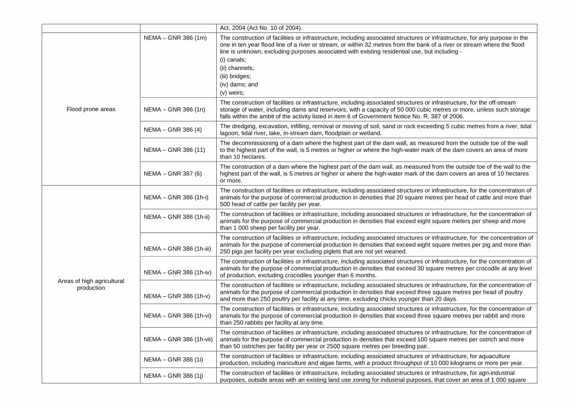
Act, 2004 (Act No. 10 of 2004).
Flood prone areas
NEMA – GNR 386 (1m) The construction of facilities or infrastructure, including associated structures or infrastructure, for any purpose in the one in ten year flood line of a river or stream, or within 32 metres from the bank of a river or stream where the flood line is unknown, excluding purposes associated with existing residential use, but including - (i) canals; (ii) channels; (iii) bridges; (iv) dams; and (v) weirs;
NEMA – GNR 386 (1n) The construction of facilities or infrastructure, including associated structures or infrastructure, for the off-stream storage of water, including dams and reservoirs, with a capacity of 50 000 cubic metres or more, unless such storage falls within the ambit of the activity listed in item 6 of Government Notice No. R. 387 of 2006.
NEMA – GNR 386 (4) The dredging, excavation, infilling, removal or moving of soil, sand or rock exceeding 5 cubic metres from a river, tidal lagoon, tidal river, lake, in-stream dam, floodplain or wetland.
NEMA – GNR 386 (11) The decommissioning of a dam where the highest part of the dam wall, as measured from the outside toe of the wall to the highest part of the wall, is 5 metres or higher or where the high-water mark of the dam covers an area of more than 10 hectares.
NEMA – GNR 387 (6) The construction of a dam where the highest part of the dam wall, as measured from the outside toe of the wall to the highest part of the wall, is 5 metres or higher or where the high-water mark of the dam covers an area of 10 hectares or more.
Areas of high agricultural production
NEMA – GNR 386 (1h-i) The construction of facilities or infrastructure, including associated structures or infrastructure, for the concentration of animals for the purpose of commercial production in densities that 20 square metres per head of cattle and more than 500 head of cattle per facility per year.
NEMA – GNR 386 (1h-ii)
The construction of facilities or infrastructure, including associated structures or infrastructure, for the concentration of animals for the purpose of commercial production in densities that exceed eight square meters per sheep and more than 1 000 sheep per facility per year.
NEMA – GNR 386 (1h-iii)
The construction of facilities or infrastructure, including associated structures or infrastructure, for the concentration of animals for the purpose of commercial production in densities that exceed eight square metres per pig and more than 250 pigs per facility per year excluding piglets that are not yet weaned.
NEMA – GNR 386 (1h-iv)
The construction of facilities or infrastructure, including associated structures or infrastructure, for the concentration of animals for the purpose of commercial production in densities that exceed 30 square metres per crocodile at any level of production, excluding crocodiles younger than 6 months.
NEMA – GNR 386 (1h-v)
The construction of facilities or infrastructure, including associated structures or infrastructure, for the concentration of animals for the purpose of commercial production in densities that exceed three square metres per head of poultry and more than 250 poultry per facility at any time, excluding chicks younger than 20 days.
NEMA – GNR 386 (1h-vi) The construction of facilities or infrastructure, including associated structures or infrastructure, for the concentration of animals for the purpose of commercial production in densities that exceed three square metres per rabbit and more than 250 rabbits per facility at any time.
NEMA – GNR 386 (1h-vii) The construction of facilities or infrastructure, including associated structures or infrastructure, for the concentration of animals for the purpose of commercial production in densities that exceed 100 square metres per ostrich and more than 50 ostriches per facility per year or 2500 square metres per breeding pair.
NEMA – GNR 386 (1i) The construction of facilities or infrastructure, including associated structures or infrastructure, for aquaculture production, including mariculture and algae farms, with a product throughput of 10 000 kilograms or more per year.
NEMA – GNR 386 (1j) The construction of facilities or infrastructure, including associated structures or infrastructure, for agri-industrial purposes, outside areas with an existing land use zoning for industrial purposes, that cover an area of 1 000 square
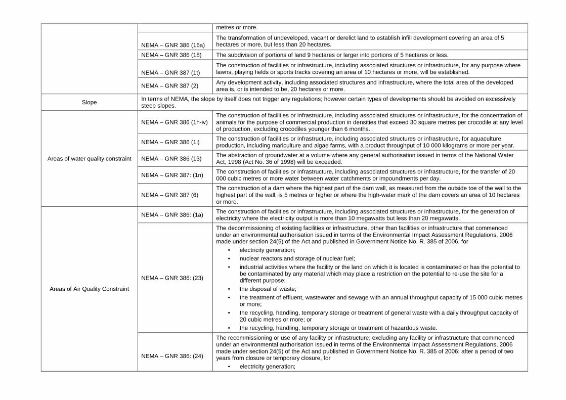
metres or more.
NEMA – GNR 386 (16a)
The transformation of undeveloped, vacant or derelict land to establish infill development covering an area of 5 hectares or more, but less than 20 hectares.
NEMA – GNR 386 (18) The subdivision of portions of land 9 hectares or larger into portions of 5 hectares or less.
NEMA – GNR 387 (1t)
The construction of facilities or infrastructure, including associated structures or infrastructure, for any purpose where lawns, playing fields or sports tracks covering an area of 10 hectares or more, will be established.
NEMA – GNR 387 (2) Any development activity, including associated structures and infrastructure, where the total area of the developed area is, or is intended to be, 20 hectares or more.
Slope In terms of NEMA, the slope by itself does not trigger any regulations; however certain types of developments should be avoided on excessively steep slopes.
Areas of water quality constraint
NEMA – GNR 386 (1h-iv) The construction of facilities or infrastructure, including associated structures or infrastructure, for the concentration of animals for the purpose of commercial production in densities that exceed 30 square metres per crocodile at any level of production, excluding crocodiles younger than 6 months.
NEMA – GNR 386 (1i) The construction of facilities or infrastructure, including associated structures or infrastructure, for aquaculture production, including mariculture and algae farms, with a product throughput of 10 000 kilograms or more per year.
NEMA – GNR 386 (13) The abstraction of groundwater at a volume where any general authorisation issued in terms of the National Water Act, 1998 (Act No. 36 of 1998) will be exceeded.
NEMA – GNR 387: (1n) The construction of facilities or infrastructure, including associated structures or infrastructure, for the transfer of 20 000 cubic metres or more water between water catchments or impoundments per day.
NEMA – GNR 387 (6) The construction of a dam where the highest part of the dam wall, as measured from the outside toe of the wall to the highest part of the wall, is 5 metres or higher or where the high-water mark of the dam covers an area of 10 hectares or more.
Areas of Air Quality Constraint
NEMA – GNR 386: (1a) The construction of facilities or infrastructure, including associated structures or infrastructure, for the generation of electricity where the electricity output is more than 10 megawatts but less than 20 megawatts.
NEMA – GNR 386: (23)
The decommissioning of existing facilities or infrastructure, other than facilities or infrastructure that commenced under an environmental authorisation issued in terms of the Environmental Impact Assessment Regulations, 2006 made under section 24(5) of the Act and published in Government Notice No. R. 385 of 2006, for
• electricity generation; • nuclear reactors and storage of nuclear fuel;
• industrial activities where the facility or the land on which it is located is contaminated or has the potential to be contaminated by any material which may place a restriction on the potential to re-use the site for a different purpose;
• the disposal of waste;
• the treatment of effluent, wastewater and sewage with an annual throughput capacity of 15 000 cubic metres or more;
• the recycling, handling, temporary storage or treatment of general waste with a daily throughput capacity of 20 cubic metres or more; or
• the recycling, handling, temporary storage or treatment of hazardous waste.
NEMA – GNR 386: (24)
The recommissioning or use of any facility or infrastructure; excluding any facility or infrastructure that commenced under an environmental authorisation issued in terms of the Environmental Impact Assessment Regulations, 2006 made under section 24(5) of the Act and published in Government Notice No. R. 385 of 2006; after a period of two years from closure or temporary closure, for
• electricity generation;
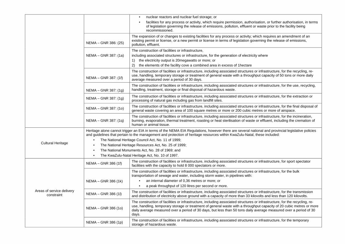
• nuclear reactors and nuclear fuel storage; or
• facilities for any process or activity, which require permission, authorisation, or further authorisation, in terms of legislation governing the release of emissions, pollution, effluent or waste prior to the facility being recommissioned.
NEMA – GNR 386: (25)
The expansion of or changes to existing facilities for any process or activity; which requires an amendment of an existing permit or license, or a new permit or license in terms of legislation governing the release of emissions, pollution, effluent.
NEMA – GNR 387: (1a)
The construction of facilities or infrastructure, including associated structures or infrastructure, for the generation of electricity where 1) the electricity output is 20megawatts or more; or 2) the elements of the facility cove a combined area in excess of 1hectare
NEMA – GNR 387: (1f)
The construction of facilities or infrastructure, including associated structures or infrastructure, for the recycling, re-use, handling, temporary storage or treatment of general waste with a throughput capacity of 50 tons or more daily average measured over a period of 30 days.
NEMA – GNR 387: (1g)
The construction of facilities or infrastructure, including associated structures or infrastructure, for the use, recycling, handling, treatment, storage or final disposal of hazardous waste.
NEMA – GNR 387: (1g) The construction of facilities or infrastructure, including associated structures or infrastructure, for the extraction or processing of natural gas including gas from landfill sites.
NEMA – GNR 387: (1o) The construction of facilities or infrastructure, including associated structures or infrastructure, for the final disposal of general waste covering an area of 100 square metres or more or 200 cubic metres or more of airspace.
NEMA – GNR 387: (1q) The construction of facilities or infrastructure, including associated structures or infrastructure, for the incineration, burning, evaporation, thermal treatment, roasting or heat sterilisation of waste or effluent, including the cremation of human or animal tissue.
Cultural Heritage
Heritage alone cannot trigger an EIA in terms of the NEMA EIA Regulations, however there are several national and provincial legislative policies and guidelines that pertain to the management and protection of heritage resources within KwaZulu-Natal, these included:
• The National Heritage Council Act, No. 11 of 1999; • The National Heritage Resources Act, No. 25 of 1999; • The National Monuments Act, No. 28 of 1969; and • The KwaZulu-Natal Heritage Act, No. 10 of 1997.
Areas of service delivery constraint
NEMA – GNR 386 (1f) The construction of facilities or infrastructure, including associated structures or infrastructure, for sport spectator facilities with the capacity to hold 8 000 spectators or more.
NEMA – GNR 386 (1k)
The construction of facilities or infrastructure, including associated structures or infrastructure, for the bulk transportation of sewage and water, including storm water, in pipelines with:
• an internal diameter of 0,36 metres or more; or • a peak throughput of 120 litres per second or more.
NEMA – GNR 386 (1l) The construction of facilities or infrastructure, including associated structures or infrastructure, for the transmission and distribution of electricity above ground with a capacity of more than 33 kilovolts and less than 120 kilovolts.
NEMA – GNR 386 (1o)
The construction of facilities or infrastructure, including associated structures or infrastructure, for the recycling, re-use, handling, temporary storage or treatment of general waste with a throughput capacity of 20 cubic metres or more daily average measured over a period of 30 days, but less than 50 tons daily average measured over a period of 30 days.
NEMA – GNR 386 (1p) The construction of facilities or infrastructure, including associated structures or infrastructure, for the temporary storage of hazardous waste.
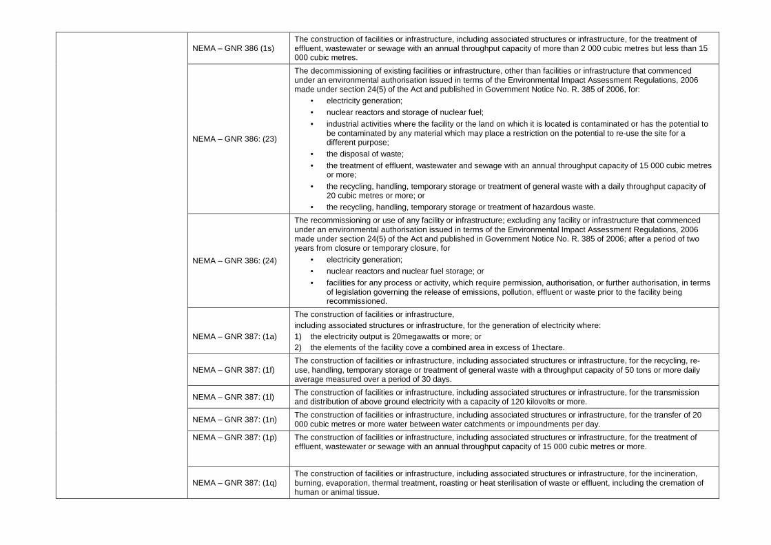
NEMA – GNR 386 (1s) The construction of facilities or infrastructure, including associated structures or infrastructure, for the treatment of effluent, wastewater or sewage with an annual throughput capacity of more than 2 000 cubic metres but less than 15 000 cubic metres.
NEMA – GNR 386: (23)
The decommissioning of existing facilities or infrastructure, other than facilities or infrastructure that commenced under an environmental authorisation issued in terms of the Environmental Impact Assessment Regulations, 2006 made under section 24(5) of the Act and published in Government Notice No. R. 385 of 2006, for:
• electricity generation; • nuclear reactors and storage of nuclear fuel;
• industrial activities where the facility or the land on which it is located is contaminated or has the potential to be contaminated by any material which may place a restriction on the potential to re-use the site for a different purpose;
• the disposal of waste;
• the treatment of effluent, wastewater and sewage with an annual throughput capacity of 15 000 cubic metres or more;
• the recycling, handling, temporary storage or treatment of general waste with a daily throughput capacity of 20 cubic metres or more; or
• the recycling, handling, temporary storage or treatment of hazardous waste.
NEMA – GNR 386: (24)
The recommissioning or use of any facility or infrastructure; excluding any facility or infrastructure that commenced under an environmental authorisation issued in terms of the Environmental Impact Assessment Regulations, 2006 made under section 24(5) of the Act and published in Government Notice No. R. 385 of 2006; after a period of two years from closure or temporary closure, for
• electricity generation; • nuclear reactors and nuclear fuel storage; or
• facilities for any process or activity, which require permission, authorisation, or further authorisation, in terms of legislation governing the release of emissions, pollution, effluent or waste prior to the facility being recommissioned.
NEMA – GNR 387: (1a)
The construction of facilities or infrastructure, including associated structures or infrastructure, for the generation of electricity where: 1) the electricity output is 20megawatts or more; or 2) the elements of the facility cove a combined area in excess of 1hectare.
NEMA – GNR 387: (1f) The construction of facilities or infrastructure, including associated structures or infrastructure, for the recycling, re-use, handling, temporary storage or treatment of general waste with a throughput capacity of 50 tons or more daily average measured over a period of 30 days.
NEMA – GNR 387: (1l) The construction of facilities or infrastructure, including associated structures or infrastructure, for the transmission and distribution of above ground electricity with a capacity of 120 kilovolts or more.
NEMA – GNR 387: (1n) The construction of facilities or infrastructure, including associated structures or infrastructure, for the transfer of 20 000 cubic metres or more water between water catchments or impoundments per day.
NEMA – GNR 387: (1p)
The construction of facilities or infrastructure, including associated structures or infrastructure, for the treatment of effluent, wastewater or sewage with an annual throughput capacity of 15 000 cubic metres or more.
NEMA – GNR 387: (1q) The construction of facilities or infrastructure, including associated structures or infrastructure, for the incineration, burning, evaporation, thermal treatment, roasting or heat sterilisation of waste or effluent, including the cremation of human or animal tissue.
SRK Consulting Msunduzi EMF Page 51
Eman/ allan 376998_Final Draft EMF_May2010 May-10
SRK Report Distribution Record
Report No. 376998/DEMF
Copy No. Public Document
Name/Title Company Copy Date Authorised by
DEMF DEAT 1 06/05/2010 P. Emanuel
DEMF DAEA RD 2 06/05/2010 P. Emanuel
DEMF Msunduzi Municipality 3 06/05/2010 P. Emanuel
Approval Signature:
This report is protected by copyright vested in SRK Consulting. It may not be reproduced or
transmitted in any form or by any means whatsoever to any person without the written permission of
the copyright holder, SRK.


![Draft Framework Contract[1] - fra.europa.eu B Draft Framework...Framework Contract No: F/SE/10/07 Page 1 DraftFrameworkContract.2010-05-11-processed.rtf ANNEX B DRAFT FRAMEWORK SERVICE](https://static.fdocuments.us/doc/165x107/5d4a0c1188c993e6068bca05/draft-framework-contract1-fra-b-draft-frameworkframework-contract-no-fse1007.jpg)