Mr. Iain Fisher California Public Utilities Commission ...
17
Mr. Iain Fisher California Public Utilities Commission July 21, 2011 Page 1 1 July 21, 2011 Mr. Iain Fisher, CEQA Project Manager Energy Division California Public Utilities Commission 505 Van Ness Avenue San Francisco, CA 94102-3296 Re: Tule Wind Project - Response to Data Request No. 17 Dear Mr. Fisher: Tule Wind, LLC (Tule Wind), a wholly owned subsidiary of Iberdrola Renewables, Inc. (IRI) received your Data Request No. 17 regarding the Tule Wind Project. Attached is Tule Wind’s response to Data Request No. 17, which includes the visual simulations depicting key observation points (KOPs) PP2, PP4, and PP6 and viewshed maps for the proposed project layout and the Reduced Modified Turbine Alternative. The associated GIS metadata can be accessed on the HDR FTP site (log-in information provided below). If you have questions regarding this information, please contact Patrick O’Neill at 858 712-8313. Sincerely, Jeffrey Durocher Senior Wind Permitting Manager cc (via e-mail): Greg Thomsen, BLM ([email protected]) Thomas Zale, BLM ([email protected]) Jeffery Childers, BLM ([email protected]) Rica Nitka, Dudek ([email protected]) Patrick O’Neill, HDR Engineering ([email protected]) Attached: Viewshed maps (2), and 3 KOP Visual Simulations for the Modified Project Layout and the Reduced Modified Turbine Alternative. KOPs and additional request for Lowenbrau Pinnacle GIS data available on FTP site. (FTP Site): 115965 (ftp://ProjectFTP.HDRInc.com/115965) User name: UAD\14466 Password: roofer5
Transcript of Mr. Iain Fisher California Public Utilities Commission ...
Mr. Iain Fisher California Public Utilities Commission July 21, 2011 Page 1
1
July 21, 2011 Mr. Iain Fisher, CEQA Project Manager Energy Division California Public Utilities Commission 505 Van Ness Avenue San Francisco, CA 94102-3296 Re: Tule Wind Project - Response to Data Request No. 17 Dear Mr. Fisher:
Tule Wind, LLC (Tule Wind), a wholly owned subsidiary of Iberdrola Renewables, Inc. (IRI) received your Data Request No. 17 regarding the Tule Wind Project. Attached is Tule Wind’s response to Data Request No. 17, which includes the visual simulations depicting key observation points (KOPs) PP2, PP4, and PP6 and viewshed maps for the proposed project layout and the Reduced Modified Turbine Alternative. The associated GIS metadata can be accessed on the HDR FTP site (log-in information provided below).
If you have questions regarding this information, please contact Patrick O’Neill at
858 712-8313.
Sincerely,
Jeffrey Durocher Senior Wind Permitting Manager
cc (via e-mail): Greg Thomsen, BLM ([email protected]) Thomas Zale, BLM ([email protected]) Jeffery Childers, BLM ([email protected]) Rica Nitka, Dudek ([email protected]) Patrick O’Neill, HDR Engineering ([email protected])
Attached: Viewshed maps (2), and 3 KOP Visual Simulations for the Modified Project Layout and the Reduced Modified Turbine Alternative. KOPs and additional request for Lowenbrau Pinnacle GIS data available on FTP site. (FTP Site): 115965 (ftp://ProjectFTP.HDRInc.com/115965) User name: UAD\14466 Password: roofer5
Mr. Iain Fisher California Public Utilities Commission July 21, 2011 Page 2
2
Visual Simulations
1. Attachment B indicates photo points requested by the Anza-Borrego Desert State Park (State Park) to be considered for visual simulations from the State Park toward the Tule Wind Project. Please provide visual simulations depicting the modified Tule Wind Project from photo points/key observation points (KOPs) PP2, PP4, and PP6 (see Attachment C for a description of these points as provided by California State Parks). Assuming implementation of the modified Tule Wind Project layout, please indicate on the visual simulations which turbines would be visible from each KOP, as well as the approximate distance to visible turbines from each KOP. In addition, please provide the same information for the Draft Environmental Impact Report/Environmental Impact Statement (DEIR/EIS) Tule Wind Reduced Turbine Alternative.
The shape files for the photo points are attached.
Response:
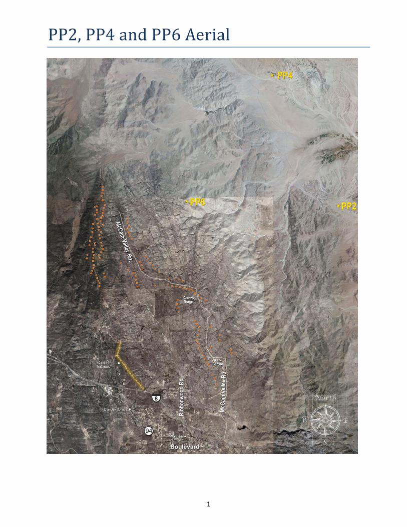
Upon review of the information provided by the California Public Utilities Commission (CPUC) as part of Data Request #17, our visual resources specialist determined that the photos were not of adequate quality (size and definition) to complete visual simulations and a photo for Sombrero Peak was not provided. IRI’s consultant prepared new existing conditions photos from key observation points (KOPs) Corrizo Gorge/Badlands Overlook (PP2), Palm Springs (PP4), and Sombrero Peak (PP6). Shape files for the existing condition photo observation points are attached. It should be noted that PP2 and PP4 are within range of roadway S-2 and accessible to the public. Sombrero Peak (PP6) is not easily accessible and requires a strenuous [3-mile] hike with a 2,000 foot elevation climb.
Visual simulations have been provided (attached) for key observation points PP2, PP4, and PP6 for the proposed project and the DEIR/EIS Reduced Turbine Alternative. The three KOP visual simulations present turbines that can be viewed from that particular photo vantage point, but do not capture a 180 degree view of the area; therefore, some of the simulations show fewer turbines than are identified in the following table. The following table is based on the viewshed analysis model, which is computer based. Please note that the existing Campo turbines and the SDG&E Sunrise Transmission Line that is currently under construction in the project area are not visible in the key observation points and therefore not included in the visual simulations.
Although Tule Wind LLC., is providing visual simulations for the DEIR/EIS Reduced Turbine Alternative, it should be noted that this alternative will result in increased impacts to air, water, biological and cultural resources as noted in Tule
Mr. Iain Fisher California Public Utilities Commission July 21, 2011 Page 3
3
Wind’s DEIR/EIS comments (March 4, 2011). The reduced turbine alternative also significantly reduces economic, community and environmental benefits.
Clean renewable energy sources have a beneficial air emissions impact as compared to conventional fossil-fuel fired generation. The Tule Wind Project will help to reduce greenhouse gas emissions and meet federal and state renewable energy mandates. In addition to the green house gas emission benefits, the project will provide benefits such as additional roadway infrastructure for local fire agencies for increase fire fighting capability, result in a net benefit to the community of Boulevard from increased business revenues from construction and operation of the project, and increased tax revenues to the County of San Diego. Because the reduced turbine alternative removes the turbines with the largest output, more turbines will be required in another location to produce the same benefits.
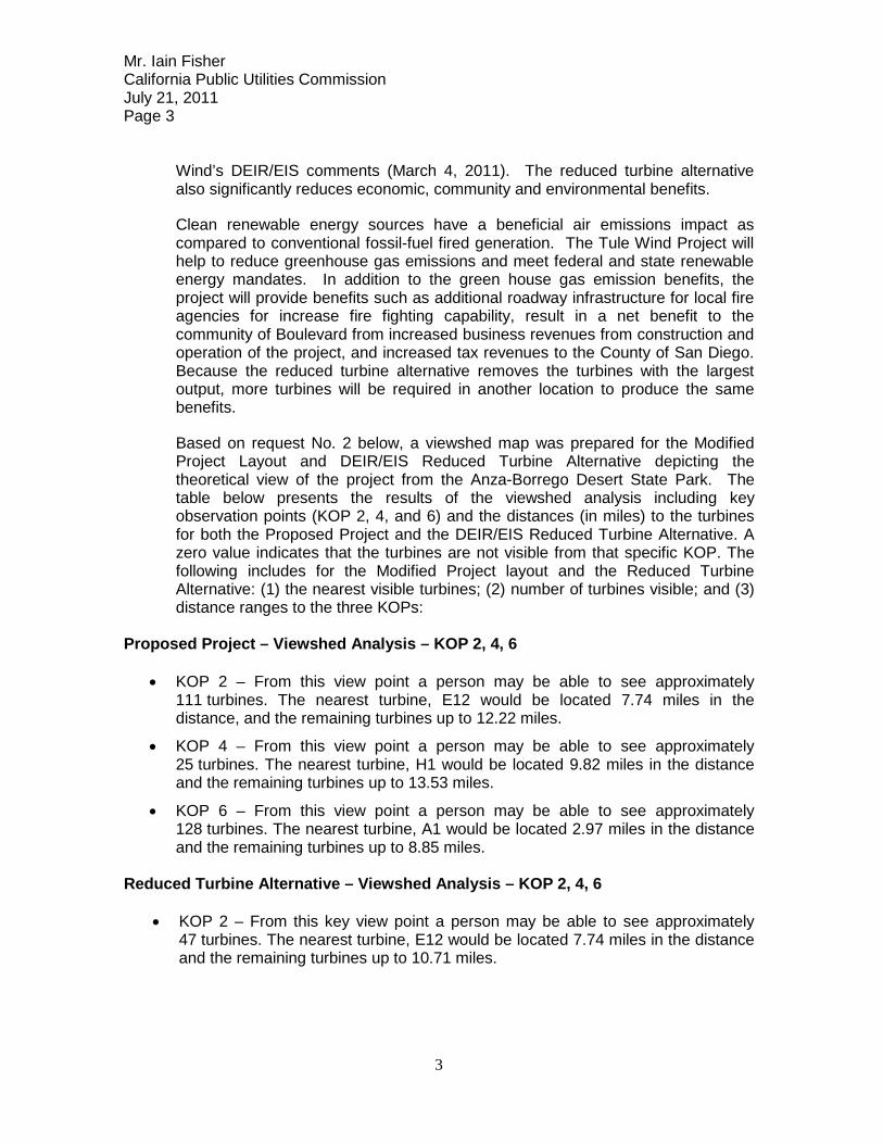
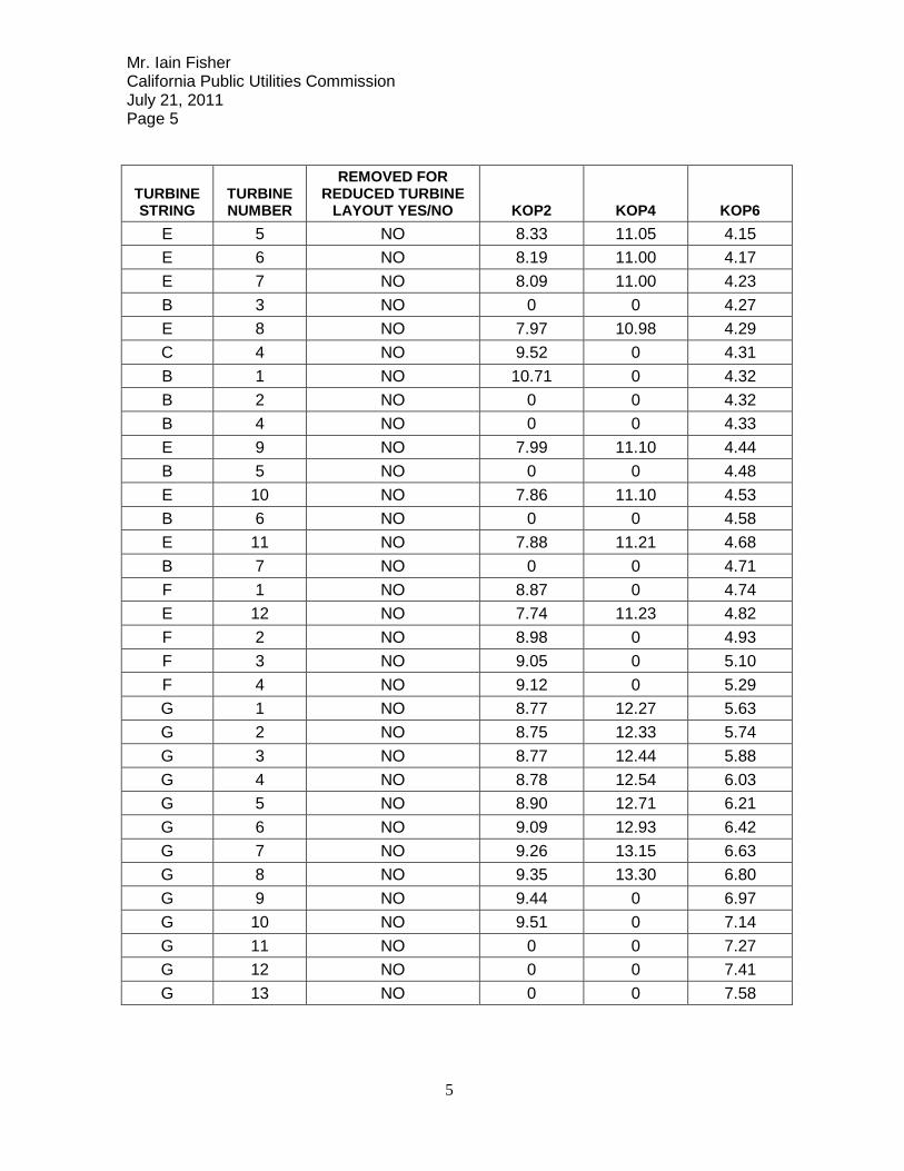
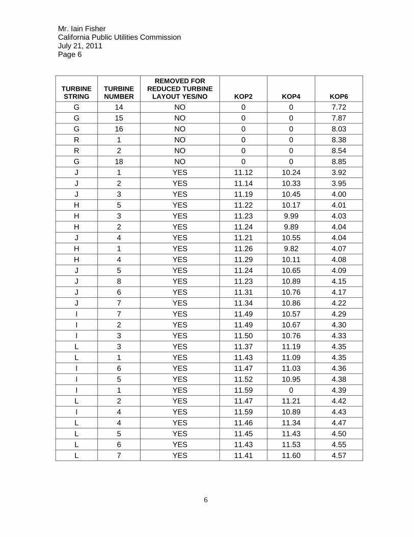
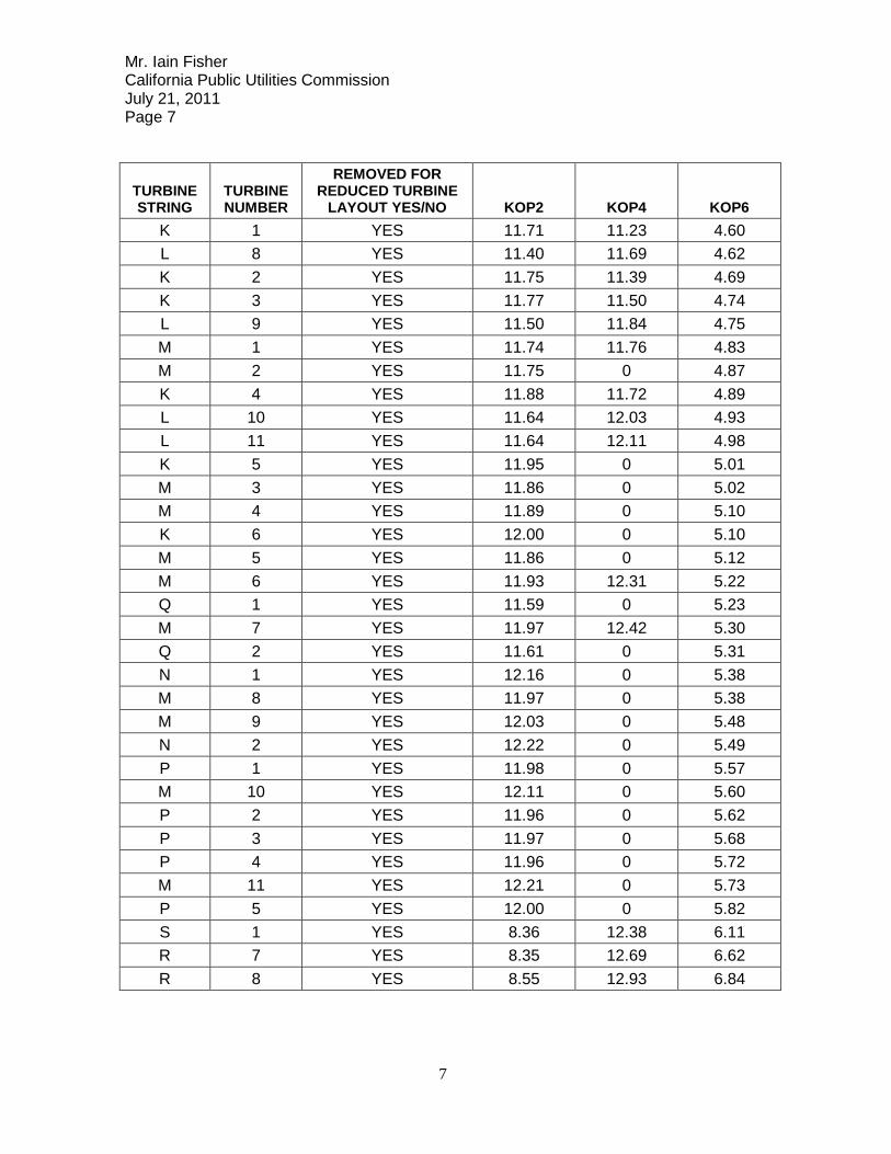
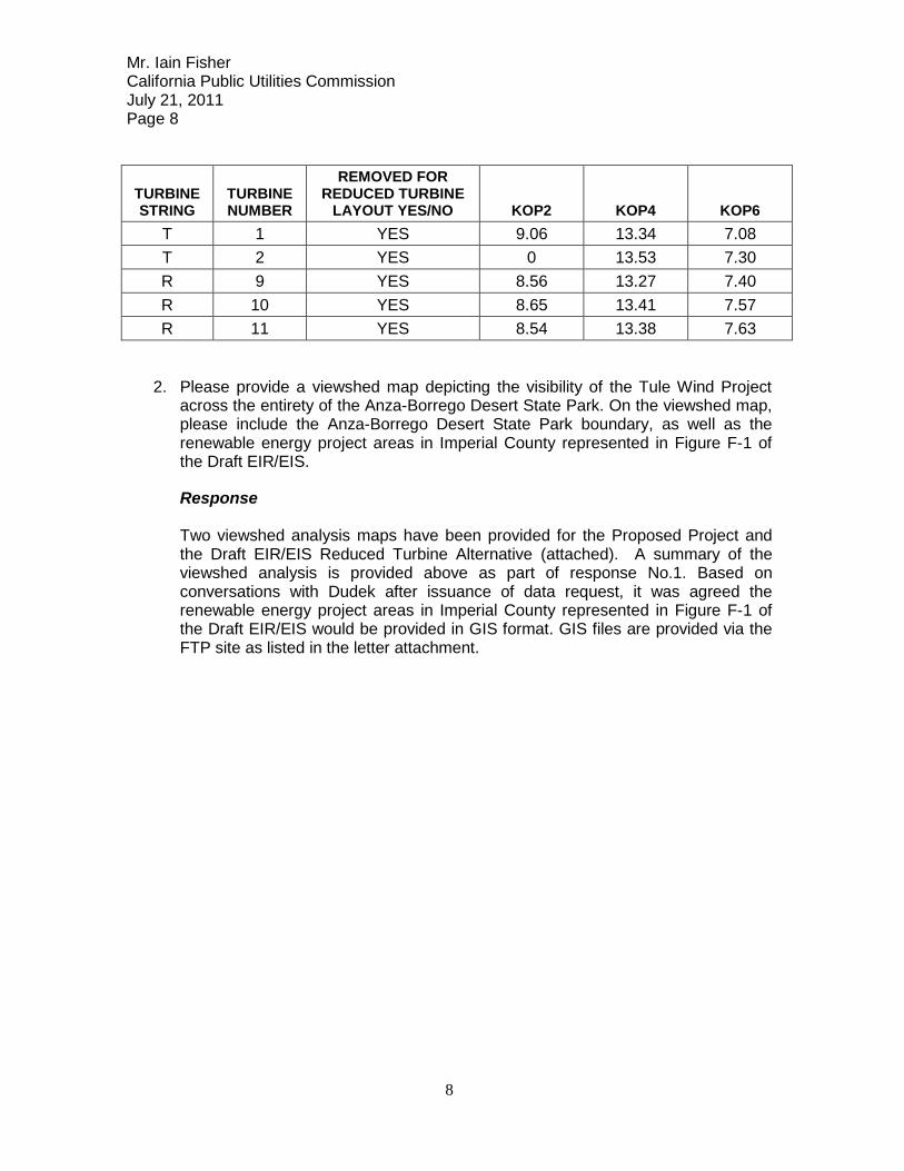
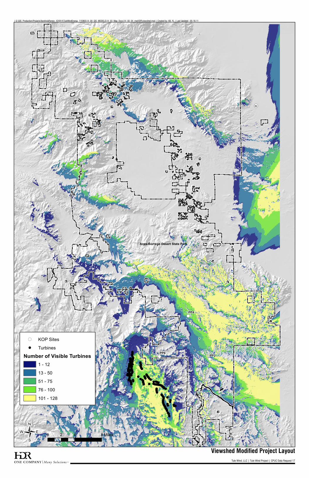
Based on request No. 2 below, a viewshed map was prepared for the Modified Project Layout and DEIR/EIS Reduced Turbine Alternative depicting the theoretical view of the project from the Anza-Borrego Desert State Park. The table below presents the results of the viewshed analysis including key observation points (KOP 2, 4, and 6) and the distances (in miles) to the turbines for both the Proposed Project and the DEIR/EIS Reduced Turbine Alternative. A zero value indicates that the turbines are not visible from that specific KOP. The following includes for the Modified Project layout and the Reduced Turbine Alternative: (1) the nearest visible turbines; (2) number of turbines visible; and (3) distance ranges to the three KOPs:
Proposed Project – Viewshed Analysis – KOP 2, 4, 6
• KOP 2 – From this view point a person may be able to see approximately 111 turbines. The nearest turbine, E12 would be located 7.74 miles in the distance, and the remaining turbines up to 12.22 miles.
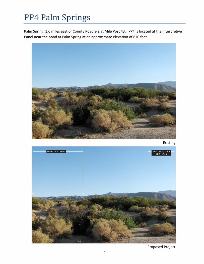
• KOP 4 – From this view point a person may be able to see approximately 25 turbines. The nearest turbine, H1 would be located 9.82 miles in the distance and the remaining turbines up to 13.53 miles.
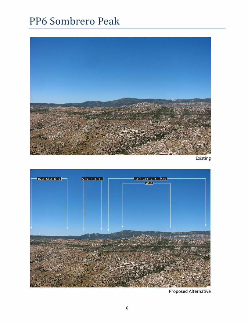
• KOP 6 – From this view point a person may be able to see approximately 128 turbines. The nearest turbine, A1 would be located 2.97 miles in the distance and the remaining turbines up to 8.85 miles.
Reduced Turbine Alternative – Viewshed Analysis – KOP 2, 4, 6
• KOP 2 – From this key view point a person may be able to see approximately 47 turbines. The nearest turbine, E12 would be located 7.74 miles in the distance and the remaining turbines up to 10.71 miles.
Mr. Iain Fisher California Public Utilities Commission July 21, 2011 Page 4
4
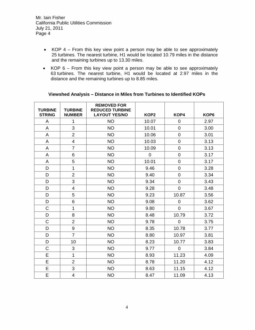
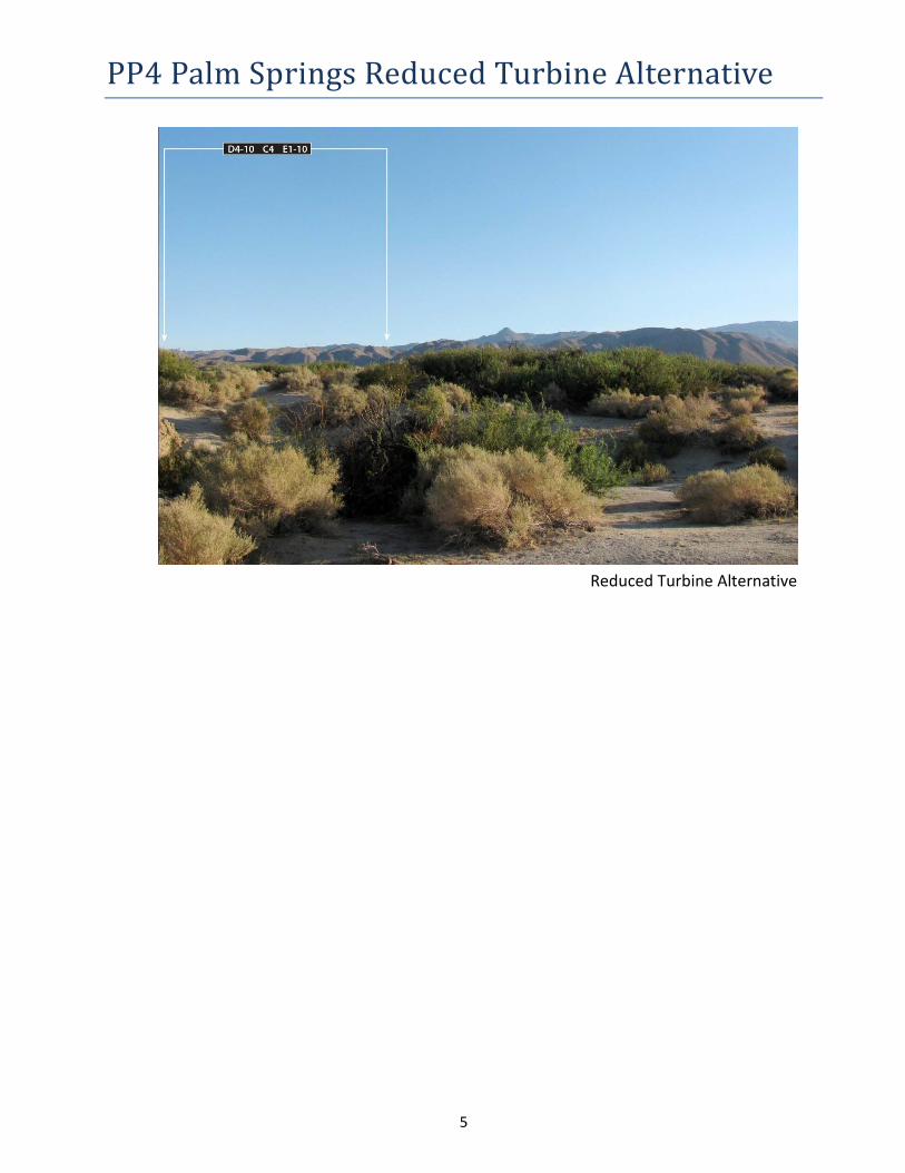
• KOP 4 – From this key view point a person may be able to see approximately 25 turbines. The nearest turbine, H1 would be located 10.79 miles in the distance and the remaining turbines up to 13.30 miles.
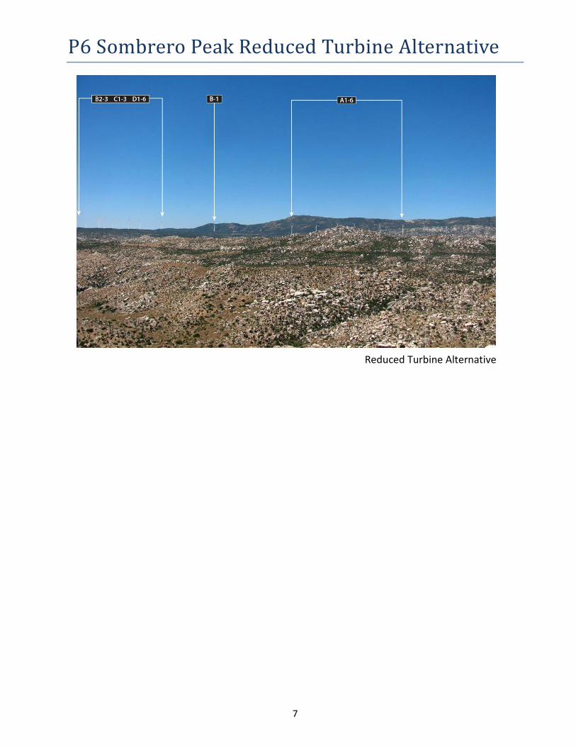
• KOP 6 – From this key view point a person may be able to see approximately 63 turbines. The nearest turbine, H1 would be located at 2.97 miles in the distance and the remaining turbines up to 8.85 miles.
Viewshed Analysis – Distance in Miles from Turbines to Identified KOPs
TURBINE STRING
TURBINE NUMBER
REMOVED FOR REDUCED TURBINE
LAYOUT YES/NO KOP2 KOP4 KOP6 A 1 NO 10.07 0 2.97 A 3 NO 10.01 0 3.00 A 2 NO 10.06 0 3.01 A 4 NO 10.03 0 3.13 A 7 NO 10.09 0 3.13 A 6 NO 0 0 3.17 A 5 NO 10.01 0 3.17 D 1 NO 9.46 0 3.28 D 2 NO 9.40 0 3.34 D 3 NO 9.34 0 3.43 D 4 NO 9.28 0 3.48 D 5 NO 9.23 10.87 3.56 D 6 NO 9.08 0 3.62 C 1 NO 9.80 0 3.67 D 8 NO 8.48 10.79 3.72 C 2 NO 9.78 0 3.75 D 9 NO 8.35 10.78 3.77 D 7 NO 8.80 10.97 3.81 D 10 NO 8.23 10.77 3.83 C 3 NO 9.77 0 3.84 E 1 NO 8.93 11.23 4.09 E 2 NO 8.78 11.20 4.12 E 3 NO 8.63 11.15 4.12 E 4 NO 8.47 11.09 4.13
Mr. Iain Fisher California Public Utilities Commission July 21, 2011 Page 5
5
TURBINE STRING
TURBINE NUMBER
REMOVED FOR REDUCED TURBINE
LAYOUT YES/NO KOP2 KOP4 KOP6 E 5 NO 8.33 11.05 4.15 E 6 NO 8.19 11.00 4.17 E 7 NO 8.09 11.00 4.23 B 3 NO 0 0 4.27 E 8 NO 7.97 10.98 4.29 C 4 NO 9.52 0 4.31 B 1 NO 10.71 0 4.32 B 2 NO 0 0 4.32 B 4 NO 0 0 4.33 E 9 NO 7.99 11.10 4.44 B 5 NO 0 0 4.48 E 10 NO 7.86 11.10 4.53 B 6 NO 0 0 4.58 E 11 NO 7.88 11.21 4.68 B 7 NO 0 0 4.71 F 1 NO 8.87 0 4.74 E 12 NO 7.74 11.23 4.82 F 2 NO 8.98 0 4.93 F 3 NO 9.05 0 5.10 F 4 NO 9.12 0 5.29 G 1 NO 8.77 12.27 5.63 G 2 NO 8.75 12.33 5.74 G 3 NO 8.77 12.44 5.88 G 4 NO 8.78 12.54 6.03 G 5 NO 8.90 12.71 6.21 G 6 NO 9.09 12.93 6.42 G 7 NO 9.26 13.15 6.63 G 8 NO 9.35 13.30 6.80 G 9 NO 9.44 0 6.97 G 10 NO 9.51 0 7.14 G 11 NO 0 0 7.27 G 12 NO 0 0 7.41 G 13 NO 0 0 7.58
Mr. Iain Fisher California Public Utilities Commission July 21, 2011 Page 6
6
TURBINE STRING
TURBINE NUMBER
REMOVED FOR REDUCED TURBINE
LAYOUT YES/NO KOP2 KOP4 KOP6 G 14 NO 0 0 7.72 G 15 NO 0 0 7.87 G 16 NO 0 0 8.03 R 1 NO 0 0 8.38 R 2 NO 0 0 8.54 G 18 NO 0 0 8.85 J 1 YES 11.12 10.24 3.92 J 2 YES 11.14 10.33 3.95 J 3 YES 11.19 10.45 4.00 H 5 YES 11.22 10.17 4.01 H 3 YES 11.23 9.99 4.03 H 2 YES 11.24 9.89 4.04 J 4 YES 11.21 10.55 4.04 H 1 YES 11.26 9.82 4.07 H 4 YES 11.29 10.11 4.08 J 5 YES 11.24 10.65 4.09 J 8 YES 11.23 10.89 4.15 J 6 YES 11.31 10.76 4.17 J 7 YES 11.34 10.86 4.22 I 7 YES 11.49 10.57 4.29 I 2 YES 11.49 10.67 4.30 I 3 YES 11.50 10.76 4.33 L 3 YES 11.37 11.19 4.35 L 1 YES 11.43 11.09 4.35 I 6 YES 11.47 11.03 4.36 I 5 YES 11.52 10.95 4.38 I 1 YES 11.59 0 4.39 L 2 YES 11.47 11.21 4.42 I 4 YES 11.59 10.89 4.43 L 4 YES 11.46 11.34 4.47 L 5 YES 11.45 11.43 4.50 L 6 YES 11.43 11.53 4.55 L 7 YES 11.41 11.60 4.57
Mr. Iain Fisher California Public Utilities Commission July 21, 2011 Page 7
7
TURBINE STRING
TURBINE NUMBER
REMOVED FOR REDUCED TURBINE
LAYOUT YES/NO KOP2 KOP4 KOP6 K 1 YES 11.71 11.23 4.60 L 8 YES 11.40 11.69 4.62 K 2 YES 11.75 11.39 4.69 K 3 YES 11.77 11.50 4.74 L 9 YES 11.50 11.84 4.75 M 1 YES 11.74 11.76 4.83 M 2 YES 11.75 0 4.87 K 4 YES 11.88 11.72 4.89 L 10 YES 11.64 12.03 4.93 L 11 YES 11.64 12.11 4.98 K 5 YES 11.95 0 5.01 M 3 YES 11.86 0 5.02 M 4 YES 11.89 0 5.10 K 6 YES 12.00 0 5.10 M 5 YES 11.86 0 5.12 M 6 YES 11.93 12.31 5.22 Q 1 YES 11.59 0 5.23 M 7 YES 11.97 12.42 5.30 Q 2 YES 11.61 0 5.31 N 1 YES 12.16 0 5.38 M 8 YES 11.97 0 5.38 M 9 YES 12.03 0 5.48 N 2 YES 12.22 0 5.49 P 1 YES 11.98 0 5.57 M 10 YES 12.11 0 5.60 P 2 YES 11.96 0 5.62 P 3 YES 11.97 0 5.68 P 4 YES 11.96 0 5.72 M 11 YES 12.21 0 5.73 P 5 YES 12.00 0 5.82 S 1 YES 8.36 12.38 6.11 R 7 YES 8.35 12.69 6.62 R 8 YES 8.55 12.93 6.84
Mr. Iain Fisher California Public Utilities Commission July 21, 2011 Page 8
8
TURBINE STRING
TURBINE NUMBER
REMOVED FOR REDUCED TURBINE
LAYOUT YES/NO KOP2 KOP4 KOP6 T 1 YES 9.06 13.34 7.08 T 2 YES 0 13.53 7.30 R 9 YES 8.56 13.27 7.40 R 10 YES 8.65 13.41 7.57 R 11 YES 8.54 13.38 7.63
2. Please provide a viewshed map depicting the visibility of the Tule Wind Project across the entirety of the Anza-Borrego Desert State Park. On the viewshed map, please include the Anza-Borrego Desert State Park boundary, as well as the renewable energy project areas in Imperial County represented in Figure F-1 of the Draft EIR/EIS.
Response
Two viewshed analysis maps have been provided for the Proposed Project and the Draft EIR/EIS Reduced Turbine Alternative (attached). A summary of the viewshed analysis is provided above as part of response No.1. Based on conversations with Dudek after issuance of data request, it was agreed the renewable energy project areas in Imperial County represented in Figure F-1 of the Draft EIR/EIS would be provided in GIS format. GIS files are provided via the FTP site as listed in the letter attachment.
!(!(
!(!(
!( !(
!(!(
!(
!(
!(
!(!(!(
!( !(!(
!(!(
!(
!(
!(!(
!(
!(!(
!(
!(
!(
!(
!(
!(
!(
!(
!(
!( !(!(
!(
!(!(
!(
!(
!(
!(
!(
!(!(!(
!(
!(
!(!(
!(
!(
!(
!(
!(
!(
!(!(
!(!(
!(
!(
!(
!(!(
!(!(!(
!(
!(
!(!(!(
!(!( !(
!(
!(
!(
!(
!(!( !(!(!(!(
!(
!(!(
!(!(
!(
!(!(!(
!(!(
!(
!(
!(
!(!(
!(
!(
!(
!(
!(
!(
!(
!(
!(
!(!(
!(
!(!(
!(
!(
!(
!(
!(
!(
!(
!(!( !(
!(
!(
Anza-Borrego Desert State Park
PP2
PP4
PP6
Viewshed Modified Project LayoutTule Wind, LLC | Tule Wind Project | CPUC Data Request 17
| G:\GIS_Production\Projects\IberdrolaRenew_424914\TuleWindEnergy_115965\14_00_GIS_MODELS\14_03_Map_Docs\14_03_04_mxd\EIR\viewshed.mxd | Created by: AB, YL | Last Updated : 05-16-11
/
¬«S2
0 4 82 Miles
!( KOP Sites!( Turbines
Number of Visible Turbines1 - 1213 - 5051 - 7576 - 100101 - 128

!(!(
!(!(
!(!(
!(
!(
!(!(
!(!(
!(
!(
!(
!(
!(!(
!(
!(
!(
!(
!(
!(!(!(
!(
!(
!(!(
!(
!(!(
!(
!(
!(
!(!( !(!(!(!(
!(
!(!(
!(
!(
!(!(
!(
!(!(!(
!(
!(
!(
!(
!(
!(!(
!(
!(!(
!(
!(
!(
Anza-Borrego Desert State Park
PP2
PP4
PP6
Viewshed Reduced Turbine Project LayoutTule Wind, LLC | Tule Wind Project | CPUC Data Request 17
| G:\GIS_Production\Projects\IberdrolaRenew_424914\TuleWindEnergy_115965\14_00_GIS_MODELS\14_03_Map_Docs\14_03_04_mxd\EIR\viewshed.mxd | Created by: AB, YL | Last Updated : 05-16-11
/
¬«S2
0 4 82 Miles
!( KOP Sites!( Turbines
Number of Visible Turbines1 - 1213 - 5051 - 75
1
PP2, PP4 and PP6 Aerial
2
PP2 Corrizo Badlands Carrizo Badlands Overlook, east of County Road S-2 at the Carrizo Badlands Interpretive Panel. View looks west/northwest to Sombrero, Thing Mountain and Thumb Rock. Approximant elevation is 1,260 feet.
Existing
Proposed
3
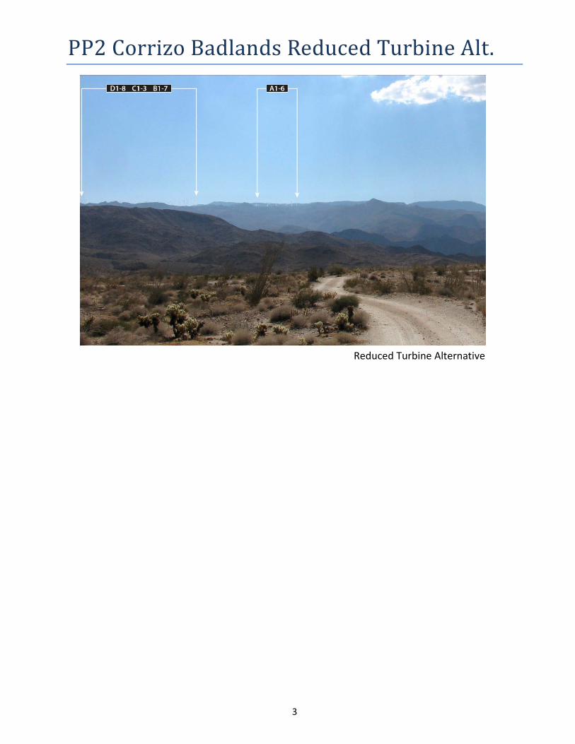
PP2 Corrizo Badlands Reduced Turbine Alt.
Reduced Turbine Alternative
4
PP4 Palm Springs Palm Spring, 1.6 miles east of County Road S-2 at Mile Post 43. PP4 is located at the Interpretive Panel near the pond at Palm Spring at an approximate elevation of 870 feet.
Proposed Project
Existing
5
PP4 Palm Springs Reduced Turbine Alternative
Reduced Turbine Alternative
6
PP6 Sombrero Peak
Existing
Proposed Alternative
7
P6 Sombrero Peak Reduced Turbine Alternative
Reduced Turbine Alternative