Mountain Home Plateau Ground Water Conditions and Management Activities Presented to the Idaho...
24
Mountain Home Plateau Ground Water Conditions and Management Activities Presented to the Idaho Legislature Natural Resources Interim Committee By Helen Harrington, IDWR August 5, 2004
-
Upload
maria-conley -
Category
Documents
-
view
213 -
download
0
Transcript of Mountain Home Plateau Ground Water Conditions and Management Activities Presented to the Idaho...
Mountain Home Plateau
Ground Water Conditions and Management Activities
Presented to the
Idaho Legislature Natural Resources Interim Committee
By Helen Harrington, IDWR
August 5, 2004

Welcome to the Western Snake
Plain• Lake and stream
sediments• Basalt appears as
interbeds and cap rock
• Subbasins• Boundary with
ESRP is in the vicinity of King Hill

#
#
#
ADA
ELMORE
Boise
Glenns Ferry
Mountain Home
Mountain Home Ground Water Management Area
Cinder Cone Butte CriticalGround Water Area
N
EW
S
General Location

Regional Geology
• Alluvium & terrace gravels• Snake River Group• Idaho Group – primary aquifer• Idavada Volcanics• Idaho Batholith
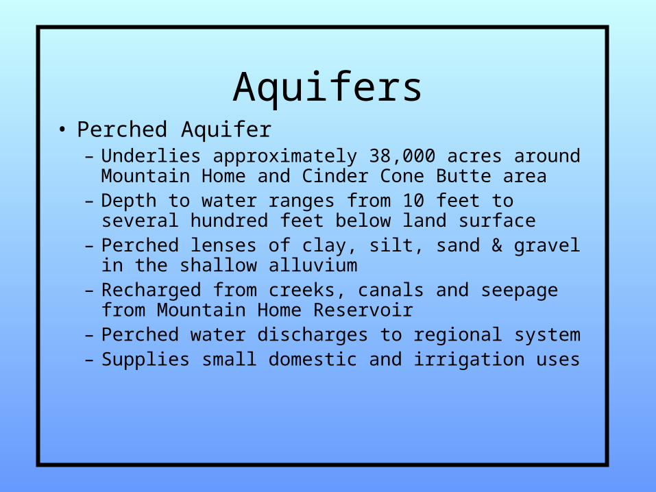
Aquifers• Perched Aquifer
– Underlies approximately 38,000 acres around Mountain Home and Cinder Cone Butte area
– Depth to water ranges from 10 feet to several hundred feet below land surface
– Perched lenses of clay, silt, sand & gravel in the shallow alluvium
– Recharged from creeks, canals and seepage from Mountain Home Reservoir
– Perched water discharges to regional system – Supplies small domestic and irrigation uses

1 N
1 S
2 S
3 S
4 S
5 S
7 E6 E5 E4 E
3 E
C IN D E R C O N E B U T T EC R IT IC A L G R O U N D W A T E R A R E A
A D A C O U N T YE L M O R E C O U N T Y
A IRB A S E
F R A S E RR E S E R V O IR
M O U N T A INH O M E
M O U N T A IN H O M ER E S E R V O IR
C A N Y O N
CREEK
L O N G T O MR E S E R V O IR
SN A K E R IV E R
M O U N T A IN H O M E G W M A
8 4
8 46 7
SIM
PC
O R
OA
D
C IN D E RC O N EB U T T E
E X T E N T O F P E R C H E DO R S H A L L O W G R O U N D W A T E R(Y O U N G , 1 9 7 6 )

Aquifers (cont.)
• Regional Aquifer– Depth to water generally greater than 250
feet– Well yields from 10 to 3500 gpm– Recharged from precipitation, streams,
perched aquifer, infiltration from irrigation– Discharges through well pumpage, springs
in Snake River canyon and underflow

G W M ABoundary
CG W ABoundary
M ounta in H om e
M tn Hom eA ir Force Base
Ada C o.
E lm ore C o.
G round W ater C ontours in the M ounta in H om e A rea
Ada
Co.
Elm
ore
Co.
G round W ater C ontours (S pring 2002)
R4ER5E
R6E R7E
T 5S
T 4S
T 3S
T 2S
T 1S
G enera lized D irection o f F low
C inder C one Butte
5 1

0 2 4 6
Map Scale (in m iles)
8 4
8 4
Ad
a C
o.
Elm
ore
Co
.S
quaw
Canyo
n Cre
ek
Cre
ek
M oun ta in H om eA ir F o rce B ase
20
M ounta in H om e
T D : 5 2 5O P : 4 8 5 -5 2 5R E G IO N A L A Q U IF E R
T D : 4 9 7O P : 2 4 0 -4 9 7R E G IO N A L A Q U IF E R
L E G E N D
M O U N T A IN H O M E G R O U N D W A T E R M A N A G E M E N T A R E A A N D C IN D E R C O N E B U T T E C R IT IC A L G R O U N D W A T E R A R E A G round W ater H yd rograp hs
T D : T O T A L D E P T HO P : IN T E R V A L A T W H IC H T H E W E L L IS P E R F O R A T E D O R O P E N T O T H E A Q U IF E RW A T E R B E A R IN G F O R M A T IO NN A : N O T A V A IL A B L E----: M O R E T H A N 1 Y E A R B E T W E E N D A T A P O IN T S L E F T S ID E : D E P T H T O W A T E RR IG H T S ID E : W A T E R E L E V A T IO NB A SE : Y E A RA L L M E A SU R E M E N T S IN F E E T
W E LL 03S 05E -07B D D 1
320
310
300
290
280
270
260
250
240
2760
2770
2780
2790
2800
2810
2820
2830
60 65 70 75 80 85 90 95 00
W ELL 01S04E-10DAD1
380
370
360
350
340
330
320
310
300
2920
2930
2940
2950
2960
2970
2980
2990
3000
60 65 70 75 80 85 90 95 00
W E LL 04S 05E -25B B C 1
475
450
425
400
375
2575
2600
2625
2650
2675
65 70 75 80 85 90 95 00
W E LL 04S 05E -13D D A 1
475
450
425
400
375
2625
2650
2675
2700
2725
65 70 75 80 85 90 95 00
W ELL 03S06E-35BCC1
475
450
425
400
375
2675
2700
2725
2750
2775
65 70 75 80 85 90 95 00
W ELL 03S06E-13BBA1
100
75
50
25
0
3150
3175
3200
3225
3250
65 70 75 80 85 90 95 00
T D : 1 5 0O P : N AP E R C H E D A Q U IF E R
T D : 9 0 2O P : 6 -9 0 2 ?R E G IO N A L A Q U IF E R
T D : 5 3 0O P :4 5 0 -5 1 0R E G IO N A L A Q U IF E R
T D : 5 7 8O P : 1 0 -5 7 8R E G IO N A L A Q U IF E R
-85
-65
-45
-25
-5
G W M ABoundary
CG W ABoundary
M tn Hom eAir Force Base
A da C o.
E lm ore C o.
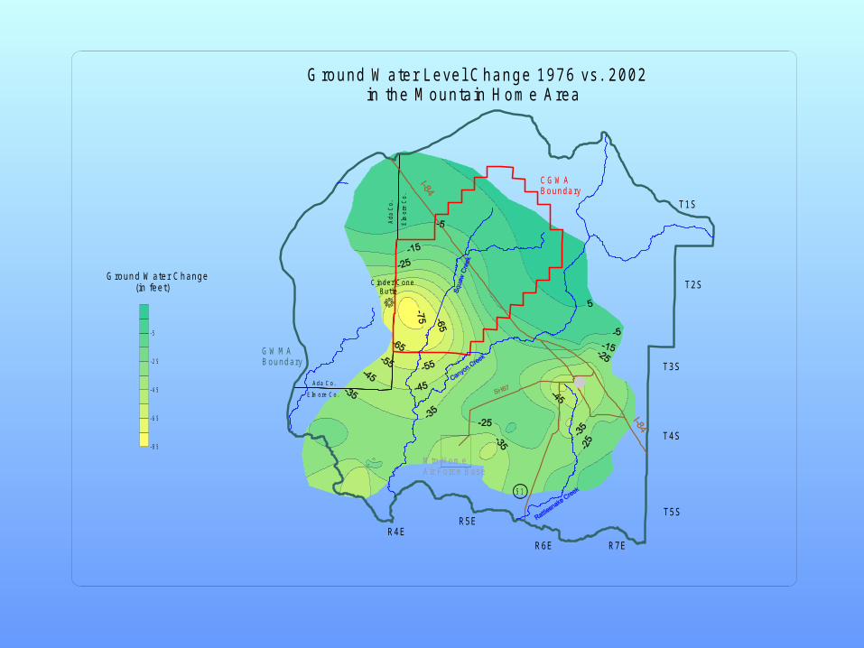
G round W ater Level C hange 1976 vs. 2002 in the M ounta in H om e Area
Ada
Co.
Elm
ore
Co.
R4ER5E
R6E R7E
T 5S
T 4S
T 3S
T 2S
T 1S
C inder C one B utte
5 1
G round W ater Change (in feet)

WATER BALANCE
• An accounting of water availability– How much water comes in to the basin– How much water is used or leaves the
basin• Positive number –water available for
current and/or future needs• Negative number – use exceeds
recharge

CANYON CREEK AT OREGON TRAIL CROSSING
0
10
20
30
40
50
60
1985
1986
1987
1988
1989
1990
1991
1992
1993
1994
1995
1996
1997
1998
1999
2000
2001
2002
2003
10
00
AC
FT
ANNUAL DISCHARGE
01/0
1 /00
01/0
1 /10
06/0
6 /2 0
01/0
1 /30
01/0
1 /40
07/0
1 /5 0
05/0
1 /60
10/2
2 /70
12/0
8 /80
05/1
9 /90
04/2
5 /00
Y E A R O F P R IO R IT Y
0
1 0 0
2 0 0
3 0 0
4 0 0
5 0 0
CU
BIC
FE
ET
PE
R S
EC
ON
D (
cfs)
L E G E N DIR R IG A T IO N
O T H E R U S E S
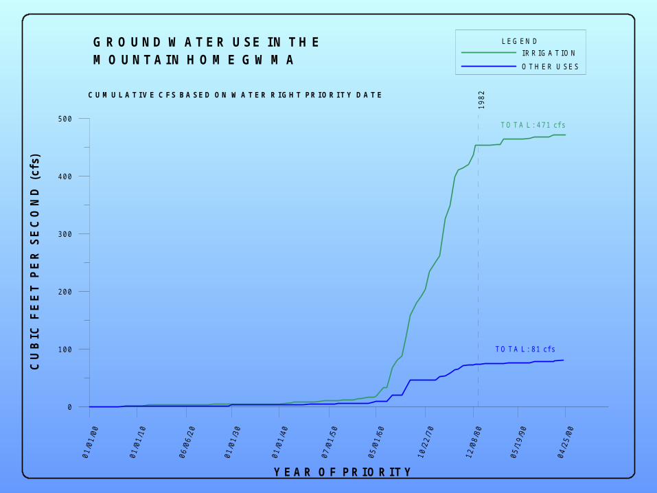
G R O U N D W A T E R U S E IN T H E M O U N T A IN H O M E G W M A
C U M U L A T I V E C F S B A S E D O N W A T E R R I G H T P R I O R I T Y D A T E
T O T A L : 4 7 1 cf s
T O T A L : 8 1 cf s
1982

02S05E
03S04E
04S05E
03S05E
04S04E
03S06E
04S06E
03S02E 03S03E
02S06E
02S04E
01S05E
02S03E
03S07E
04S07E
01S04E
05S06E
04S03E
05S07E
02S02E02S07E
05S05E05S04E
03S01E
01S06E01S03E
04S02E
01N05E
02S01E
05S03E
Township/RangeStudy BoundaryIrrigated Acres (1998)Supplemental AcresAcres Irrigated from Snake River
10 0 10 20 Miles
N
EW
S
Total Irrigated Acres: 46,328
Ground Water 28,815
Surface Water 17,513Snake River (15,451)
Surface&GW 5,681
IRRIGATED ACRES

WATER BALANCE (in acre-feet per year) Basin Inflow and Supply Supply/Use
Canyon Creek yield 20,900Little Camas Creek (imported) 9,500Rattlesnake Creek yield 3,800Ditto Creek and adjacent areas 4,100Precipitation on rocky areas 4,400
Total 42,700 Consumptive Use and Loss
Loss to Snake River 1,500Use by irrigated crops 69,600Use by Municipal and Air Base 2,500
Total 73,600 Inflow Minus Use -30,900

# Mountain Home
N
EW
S
Management Designations
CINDER CONE BUTTECRITICAL GROUND WATER AREAdesignated May 7, 1981
MOUNTAIN HOME GROUND WATER MANAGEMENT AREAdesignated November 9, 1982

Reasons for Designation
• Rapid agricultural development • Declines in ground water levels• Further information showed
declines over a larger area• Pending applications for
additional development of ground water

Administrative Restrictions
• Cinder Cone Butte CGWA– No new
appropriations
• Mountain Home GWMA– New
appropriations allowed if it is determined that sufficient supply is available and prior water rights will not be injuredException: Domestic uses and associated
domestic irrigation

Management Strategies
• Creation of advisory committee– Established by Director in 1996– Local representation, 10 members– Objectives:
• Develop recommendations for ground water management plan
• Develop ground water recharge program• Act as forum for data collection, review and
mediation• Act as forum for communication with community

Advisory Committee
• In 1999, a recharge project was initiated. – Source: Canyon Creek– Method: Infiltration through existing
gravel pits– Amount recharged: Approximately
1200-1500 acre feet– Impact: Undetectable change

Potential Sources for Managed Recharge
• Canal lining from Little Camas Reservoir• Canyon Creek
– Highly variable discharge– Primary source of water for Mountain Home
Irrigation District
• Snake River – Requires pumping and transport– Water availability
• Other local basins

G W M ABoundary
CG W ABoundary
M ountain H om e
M tn Hom eAir Force Base
A da C o.
E lm ore C o.
Boundaries, G round W ater Leve l C hange and G round W ater C ontours in the M ounta in H om e A rea
Ada
Co.
Elm
ore
Co
.
G round W ater C ontours (Spring 2002)
R4ER5E
R6E R7E
T 5S
T 4S
T 3S
T 2S
T 1S
G eneralized D irection of F low
Cinder Cone Butte
5 1

Information Needs
• Subsurface structures controlling water movement
• Ground water level information in specific locations

Thank You