Mount Gilead Downtown Historic District · The Mount Gilead Downtown Historic District, ... but...
32
NORTH CAROLINA STATE HISTORIC PRESERVATION OFFICE Office of Archives and History Department of Cultural Resources NATIONAL REGISTER OF HISTORIC PLACES Mount Gilead Downtown Historic District Mount Gilead, Montgomery County, MG0037, Listed 12/23/2005 Nomination by Edward F. Turberg Photographs by Janet Seapker, August 2004 See photo at the end of the nomination
-
Upload
trinhthien -
Category
Documents
-
view
231 -
download
3
Transcript of Mount Gilead Downtown Historic District · The Mount Gilead Downtown Historic District, ... but...

NORTH CAROLINA STATE HISTORIC PRESERVATION OFFICE Office of Archives and History Department of Cultural Resources
NATIONAL REGISTER OF HISTORIC PLACES
Mount Gilead Downtown Historic District Mount Gilead, Montgomery County, MG0037, Listed 12/23/2005 Nomination by Edward F. Turberg Photographs by Janet Seapker, August 2004
See photo at the end of the nomination

NPS Form 10-900 OMB No. 1024-0018(Rev. 10-90)
United States Department of the InteriorNational Park Service
NATIONAL REGISTER OF HISTORIC PLACESREGISTRATION FORM
This form is for use in nominating or requesting determinations for individual properties and districts. See instructions in How to Complete the NationalRegister of Historic Places Registration Form (National Register Bulletin 16A). Complete each item by marking "x" in the appropriate box or by enteringthe information requested. If any item does not apply to the property being documented, enter "N/A" for "not applicable." For functions, architecturalclassification, materials, and areas of significance, enter only categories and subcategories from the instructions. Place additional entries and narrativeitems on continuation sheets (NPS Form 10-900a). Use a typewriter, word processor, or computer, to complete all items.
_________________________________________________________________________________________________1. Name of property________________________________________________________________________________
historic name Mount Gilead Downtown Historic District
other names/site number N/A2. Location_______________________________________________________________________________________
street & number Both sides of North and South Main Street from First Avenue on the north to 106 and117 South Main Street on the south, and the north and south sides of the 100 block of West AllentonStreet. not for publication N/A
city or town Mt. Gilead vicinity N/A
state North Carolina code NC county Montgomery code 123 zip code 27306
3. State/Federal Agency Certification_________________________________________________________________
As the designated authority under the National Historic Preservation Act of 1986, as amended, I hereby certify that this __X__ nomination____ request for determination of eligibility meets the documentation standards for registering properties in the National Register of HistoricPlaces and meets the procedural and professional requirements set forth in 36 CFR Part 60. In my opinion, the property
_X___ meets ____ does not meet the National Register Criteria. I recommend that this property be considered significant___ nationally ___ statewide _X _ locally. ( ___ See continuation sheet for additional comments.)
________________________________________________ _______________________Signature of certifying official Date
_North Carolina Department of Cultural Resources ________________________________________________State or Federal agency and bureau
In my opinion, the property ____ meets ____ does not meet the National Register criteria. ( ___ See continuation sheet for additionalcomments.)
________________________________________________ _______________________Signature of commenting or other official Date
________________________________________________________________________State or Federal agency and bureau
_________________________________________________________________________________________________________________________
4. National Park Service Certification_________________________________________________________________
I, hereby certify that this property is: Signature of the Keeper Date of Action
____ entered in the National Register ______________________________________________________________________________ See continuation sheet.
____ determined eligible for the ___________________________________________________________________________National Register
___ See continuation sheet.____ determined not eligible for the ___________________________________________________________________________
National Register____ removed from the National Register ___________________________________________________________________________
____ other (explain): _________________ ___________________________________________________________________________
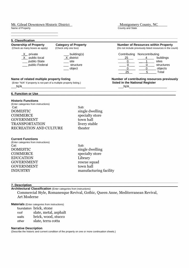
Mt. Gilead Downtown Historic District _ _Montgomery County, NC_____Name of Property County and State
_____________________________________________________________________________________________________________________________________________________________________________________________
5. Classification___________________________________________________________________________________
Ownership of Property Category of Property Number of Resources within Property(Check as many boxes as apply) (Check only one box) (Do not include previously listed resources in the count)
X_ private ___ building(s) Contributing Noncontributing_X public-local X district ____25___ ___ 4 buildings___ public-State ___ site _____0 ___ __ 1____ sites___ public-Federal ___ structure ____ 0 ___ ____0____ structures
___ object _____0____ ___ 0_____ objects____25__ 5_____ Total
Name of related multiple property listing Number of contributing resources previously(Enter "N/A" if property is not part of a multiple property listing.) listed in the National Register
___N/A_____________________________________ ___N/A______________________________________________________________________________________________________________________6. Function or Use________________________________________________________________________________
Historic Functions(Enter categories from instructions)
Cat: Sub:
DOMESTIC single dwellingCOMMERCE specialty storeGOVERNMENT town hallTRANSPORTATION livery stableRECREATION AND CULTURE theater
Current Functions(Enter categories from instructions)
Cat: Sub:
DOMESTIC single dwellingCOMMERCE specialty storeEDUCATION LibraryGOVERNMENT rescue squadGOVERNMENT town hallINDUSTRY manufacturing facility
_________________________________________________________________________________________________7. Description_____________________________________________________________________________________Architectural Classification (Enter categories from instructions)
Commercial Style, Romanesque Revival, Gothic, Queen Anne, Mediterranean Revival,Art Moderne
Materials (Enter categories from instructions)
foundation brick, stoneroof slate, metal, asphaltwalls brick, wood, stuccoother slate, terra cotta
Narrative Description(Describe the historic and current condition of the property on one or more continuation sheets.)

Mt. Gilead Downtown Historic District _ _Montgomery County, NC_____Name of Property County and State
_________________________________________________________________________________________________8. Statement of Significance_________________________________________________________________________Applicable National Register Criteria(Mark "x" in one or more boxes for the criteria qualifying the propertyfor National Register listing)
__X__ A Property is associated with events that havemade a significant contribution to the broad patterns ofour history.
__ __ B Property is associated with the lives ofpersons significant in our past.
__X__ C Property embodies the distinctivecharacteristics of a type, period, or method ofconstruction or represents the work of a master, orpossesses high artistic values, or represents asignificant and distinguishable entity whose componentslack individual distinction.
____ D Property has yielded, or is likely to yieldinformation important in prehistory or history.
Criteria Considerations(Mark "X" in all the boxes that apply.)
____ A owned by a religious institution or used forreligious purposes.
____ B removed from its original location.
____ C a birthplace or a grave.
____ D a cemetery.
____ E a reconstructed building, object,or structure.
____ F a commemorative property.
____ G less than 50 years of age or achievedsignificance within the past 50 years.
Areas of Significance(Enter categories from instructions)
CommerceArchitecture____________________________________________________________________________________________________________________________________________________________________________________________________________________________________________________________
Period of Significance
1900-1955____________________________________________________
Significant Dates
1900, 1910__________________________
___________________________
Significant Person(Complete if Criterion B is marked above)
_____N/A__________________________
Cultural Affiliation______N/A__________________________________________________________________________________________
Architect/Builder
Haywood, W.T. - architect/contractor;Holt, Dewitt - builder___________________________________
Narrative Statement of Significance(Explain the significance of the property on one or more continuation sheets.)
_________________________________________________________________________________________________9. Major Bibliographical References__________________________________________________________________Bibliography(Cite the books, articles, and other sources used in preparing this form on one or more continuation sheets.)
Previous documentation on file (NPS)___ preliminary determination of individual listing (36 CFR 67) has been requested.___ previously listed in the National Register___ previously determined eligible by the National Register___ designated a National Historic Landmark___ recorded by Historic American Buildings Survey # _____________ recorded by Historic American Engineering Record # __________
Primary Location of Additional Data_X_ State Historic Preservation Office___ Other State agency___ Federal agency___ Local government___ University___ OtherName of repository: ___________________________________

Mt. Gilead Downtown Historic District _ _Montgomery County, NC_____Name of Property County and State
_________________________________________________________________________________________________10. Geographical Data______________________________________________________________________________
Acreage of Property Approx. 8
UTM References (Place additional UTM references on a continuation sheet)
Zone Easting Northing Zone Easting NorthingA 17 590820 3897280 C 17 590800 3897000B 17 590920 3896040 D 17 590660 3897200
Verbal Boundary Description(Describe the boundaries of the property on a continuation sheet.)
Boundary Justification(Explain why the boundaries were selected on a continuation sheet.)
_________________________________________________________________________________________________11. Form Prepared By______________________________________________________________________________
name/title Edward F. Turberg, Architectural Historian
organization Consultant to Town of Mt. Gilead date July 15, 2005
street & number 307 North 15th Street telephone 910-762-6301
city or town Wilmington state NC zip code 28401-3813_________________________________________________________________________________________________12. Additional Documentation_______________________________________________________________________Submit the following items with the completed form:
Continuation Sheets
MapsA USGS map (7.5 or 15 minute series) indicating the property's location.A sketch map for historic districts and properties having large acreage or numerous resources.
PhotographsRepresentative black and white photographs of the property.
Additional items (Check with the SHPO or FPO for any additional items)_________________________________________________________________________________________________Property Owner __________________________________________________________________________________(Complete this item at the request of the SHPO or FPO.)
name Multiple owners
street & number___________________________________ telephone_________________
city or town____________________________________ state_____ zip code ___________________________________________________________________________________________________________Paperwork Reduction Act Statement: This information is being collected for applications to the National Register of Historic Places to nominateproperties for listing or determine eligibility for listing, to list properties, and to amend existing listings. Response to this request is required to obtain abenefit in accordance with the National Historic Preservation Act, as amended(16 U.S.C. 470 et seq.).Estimated Burden Statement: Public reporting burden for this form is estimated to average 18.1 hours per response including the time for reviewinginstructions, gathering and maintaining data, and completing and reviewing the form. Direct comments regarding this burden estimate or any aspect ofthis form to the Chief, Administrative Services Division, National Park Service, P.0. Box 37127, Washington, DC 20013-7127; and the Office ofManagement and Budget, Paperwork Reductions Project (1024-0018), Washington, DC 20503.

NPS Form 10-900-a OMB Approval No. 1024-0018(8-86)
United States Department of the InteriorNational Park Service
National Register of Historic PlacesContinuation Sheet
Mount Gilead Downtown Historic DistrictSection Number 7 Page 1 Montgomery County, North Carolina______________________________________________________________________
Narrative Description
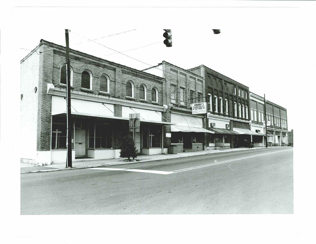
Mount Gilead, a rural Piedmont town with a population of just under 1,400, is situated three and ahalf miles northeast of the Pee Dee River in the southwestern sector of Montgomery County,North Carolina. The Mount Gilead Downtown Historic District, laid out in a grid pattern,comprises two blocks along North and South Main streets, one block along West Allenton Street,containing a total of twenty-nine buildings. Of these, twenty-five (86%) are commercial buildings;three (10%) are public buildings including the Town Hall (originally a theater), Town Hall Annex(originally the Jail), and Library (originally the post office); and one is a church. There is a smallpocket park on West Allenton Street adjacent to the Library.
All of the contributing resources in the Mount Gilead Downtown Historic District exhibit highlevels of integrity because they preserve almost totally intact the historic architectural character ofa small, turn-of-the-century Piedmont town, high standards of brick and stone work; maintenanceof intact storefronts with their original recessed entrances, double-leaf doors, and leaded-glasstransoms; and decorative pressed metal cornices terminating in ornamental end brackets. Inaddition to its buildings, open public areas in the Mount Gilead Downtown Historic District attractresidents and visitors with lush expanses of lawns and landscaping around the Methodist church,flowers in urns spaced neatly along the sidewalks and a Veterans’ Memorial Park across from theTown Hall on West Allenton Street. A vacant lot near the northwest end of North Main Street hasalways been an open space, where cotton bales and other produce once were collected and sold.Main Street occupies a high elevation of the town, the terrain sloping down to the east and west sothat many of the stores are accessible by one to three steps above the sidewalk at the front, and area full story above the ground at the rear. Allenton Street has a level grade to the west of MainStreet, but descends on the east into a low dale through which runs Little Hamer Creek.
Outside the Mount Gilead Downtown Historic District boundaries stand modern, noncontributingbuildings dating to the 1970s and later: police headquarters, fire department, two banks, fast foodand service stations, two industrial plants, and a water works all close to but not encroaching onthe historic and architectural ambience of the old section of town. School Street, parallel to andwest of Main Street is the site of the 1928 Mt. Gilead Elementary and High schools, designed byLeslie N. Boney Architects of Wilmington, North Carolina. Only the auditorium survives from thetriumvirate of brick structures, although an extremely rare example of a gymnasium faced withwide courses of slate, a W.P.A. project dating to 1935, stands behind the auditorium. The railroadtracks, which run from Charlotte to Raleigh through the middle of Montgomery County, arelocated three blocks north of the intersection of North Main and Allenton streets and roughlyparallel Highway NC-731 on the southwest and Highway NC-109 on the northeast. The 1926

NPS Form 10-900-a OMB Approval No. 1024-0018(8-86)
United States Department of the InteriorNational Park Service
National Register of Historic PlacesContinuation Sheet
Mount Gilead Downtown Historic DistrictSection Number 7 Page 2 Montgomery County, North Carolina______________________________________________________________________
Sanborn map (the only insurance map of the town) depicts a large lumber mill, ice plant, and threecotton warehouses adjacent to the passenger and freight depot. By 1938 the Union Mills hosieryplant was constructed by the Richter family south of the railroad tracks, but by 1960 all of theearlier buildings had been razed.
Beyond Mount Gilead’s commercial core the picturesque and undulating topography extends inall directions reaching areas of great geologic, archaeological, and historical interest. Westtoward the Pee Dee Valley and Lake Tillery, populated by sportsmen and bordered by modernresidential subdivisions, is the ancient Yadkin/Pee Dee River Basin. To the north and east is theUwharrie National Forest, a 50,000-acre wilderness with hills rising 1000 feet from the riverbank, purchased by the U.S. Government in 1931 and proclaimed a National Forest by PresidentJohn F. Kennedy in 1961—the most recent of four National Forests in the state. The county seatof Troy is twelve miles to the northeast; and Town Creek Indian Mound State Historic Site isabout the same distance to the southeast.
All of the commercial and church buildings in the Mount Gilead Downtown Historic District areof brick construction. Several structures incorporate local sandstone used in door and window sillsand lintels, and the predominant material for the coping atop the flat parapets is terra-cotta tile.Both of the churches and four of the residences are covered with gray slate roofs. One buildingwas refaced on its side elevation by a rough cement finish, but the principal facade preserves itsoriginal narrow joint brick veneer facing. Thirteen commercial and public buildings (38%) are onestory high, twelve (26%) are two stories tall, and three (10%) rise to two-and-a-half or threestories. The church is two-stories in height with asymmetrical towers reaching two and three levelssurmounted by steeples. The stores form handsome rows of interrelated fenestration, recessedentrances, pressed metal cornices, and a unity of design in the repetition of corbelled brickcornices, suggesting that one contractor may have built the entire business district. Although thename of the architect/builder of these structures is not certain, an important local builder wasWilliam Thaddeus (Will) Haywood, an engineer who listed himself as an architect in the 1910census, who is credited with erecting both the Methodist and Baptist churches, and several privateresidences in and around the town. Other regional builders were Dewitt Holt and Vernon L.Shankle who constructed both commercial and residential structures in the county seat of Troy,and worked in Mount Gilead and other towns in the region as well.
The architectural resources of Mount Gilead can be categorized as late-nineteenth and early-twentieth century designs, styles that were widely popular during a period of rapid adoption ofarchitectural fashions. The trend was motivated by the railroad which brought building products tocities, towns, and rural areas; delivered design books and mail-order catalogues to prospective

NPS Form 10-900-a OMB Approval No. 1024-0018(8-86)
United States Department of the InteriorNational Park Service
National Register of Historic PlacesContinuation Sheet
Mount Gilead Downtown Historic DistrictSection Number 7 Page 3 Montgomery County, North Carolina______________________________________________________________________
customers; and conveyed tradesmen with expertise in building into the region. In addition tomaterials brought in from other railroad-serviced areas, Montgomery County and Mt. Gilead hadan abundance of timber, clay, stone, and slate to provide for any sort of construction that wasneeded or desired by owners and builders. Two commercial buildings, at 101 North Main Streetand 100 South Main Street incorporate Romanesque-arched windows, the remaining resourceshaving trabeated openings with brick or stone sills and lintels. The principal facades of all thebuildings are faced with running bond pressed brick with narrow mortar joints, the side and rearelevations containing one-to-five common bond brick coursing. In addition, pilasters dividingwindow bays, corbelled cornices, and brick or stone window and door trim, are features of theearly twentieth-century buildings. Of particular note are the numerous examples of storefronts thatretain their original plate glass display windows, patterned glass transoms, and decorative pressedmetal cornices. Of the latter, thirteen commercial structures retain all or most of their earlytwentieth century storefronts: 104 West Allenton Street; 101, 103, 105-107, 106-110, 109, 111-115, 114, 116, and 118 North Main Street; and 100, 101, and 104 South Main Street. The centercity church exhibits a high level of architectural design that testifies to the knowledge of andability to execute fine craftsmanship by the builder, W.T. Haywood. Four buildings arenoncontributing resources in the Mount Gilead Downtown Historic District: 112 North MainStreet, which replaced a building that burned in the 1960s; 120 North Main Street, a remodeling ofan earlier structure; 105-107 West Allenton Street, and 109 West Allenton Street.
Inventory List
The inventory list provides basic information about each resource located within the Mount GileadDowntown Historic District, including the following: numerical address, historic or commonname, construction date, contributing or noncontributing status, and brief description of thephysical appearance and history. The descriptions are based upon on-site observation,investigation of Sanborn Map Company insurance maps (only one set was produced: in July1926), study of historic photographs, research into historical publications and interview tapes, anddiscussions with local residents familiar with the town’s history and architecture. Twopublications were especially informative: Mable S. Lassiter’s Patterns of Timeless Moments: AHistory of Montgomery County (1976) and Catherine Watkins McKinnon’s History of Mt. Gilead,North Carolina (1971). Where no certain date of construction is known an approximation is givendepending on whether the resource is shown in a dated photograph, appears on the 1926 insurancemap, or is remembered as being extant at a certain time in the life of a person being interviewed.
The Mount Gilead Downtown Historic District inventory is listed in a street by street progression,beginning on the north side of West Allenton Street and running east to west through the 100

NPS Form 10-900-a OMB Approval No. 1024-0018(8-86)
United States Department of the InteriorNational Park Service
National Register of Historic PlacesContinuation Sheet
Mount Gilead Downtown Historic DistrictSection Number 7 Page 4 Montgomery County, North Carolina______________________________________________________________________
block; then continuing on the south side of the same street, running in the same direction, east-west; then along the east side of North Main Street, moving from south to north in the 100 block;continuing in the same direction on the west side of the 100 block of North Main Street; then onthe west side of South Main Street and running south through the 100 block; then south throughthe east side of the 100 block of South Main Street. The buildings, listed according to their streetaddresses, are keyed to the town plan containing the marked boundaries of the Mount GileadDowntown Historic District.
Contributing resources are defined as buildings or sites that were present during the period ofsignificance, relates to the historic significance of the district, and possess historic integrity.Noncontributing resources are defined as buildings or sites that were constructed after the periodof significance or due to alterations or additions no longer possess sufficient historic integrity.
North side 100 block of West Allenton Street
102 J.A. McAulay Store Annex 1910 Contributing building
One-story, brick, with later stucco facing, recessed storefront contains original double-leaf glazed door; transom glass covered; aluminum awning; flat roof and parapet. Thebuilding is an annex to the two-story main structure at 101 North Main Street.
104-106 Ingram-McAulay Appliances 1910 Contributing building
One-story, brick, running bond red brick, four bays wide with recessed entrances insecond and fourth bays. Second-bay preserves original double-leaf glazed and paneldoors, fourth bay has later metal door; original small-pane, ribbed transom glass intactacross facade (fourth bay transom covered); upper wall is divided into three sections bybrick pilasters, flat roof and parapet. The building is a furniture store annex to the two-story main structure at 103 North Main Street where hardware, fertilizer, plants, andfarm supplies were sold.
108 Harris Building 1916 Contributing building
One-story, painted brick, running bond pattern, three bays wide with modern storefrontand entrances in left bay; Upper wall contains six, recessed, square panels, flat roof andparapet. In 1916 the building became the first Ford franchise in Mt. Gilead, operated by

NPS Form 10-900-a OMB Approval No. 1024-0018(8-86)
United States Department of the InteriorNational Park Service
National Register of Historic PlacesContinuation Sheet
Mount Gilead Downtown Historic DistrictSection Number 7 Page 5 Montgomery County, North Carolina______________________________________________________________________
Ratio Harris. Later it served as the Town Hall. It is currently a NAPA Auto Partsbusiness.
110-112 Mt. Gilead Town Hall and Annex 1939; 1955; 1960 Contributing building
Two-story, red brick with running bond courses at front and 1:5 common bond in sideelevations. One bay wide with recessed entrance incorporating modern aluminum-claddoor and windows framed by wide surround of white stucco containing legend MT.GILEAD TOWN HALL and two small octagonal side windows. Upper wall contains asmall multi-light window and cement parapet coping. The original building on the site,Moore’s Livery, was built by L.P. Byrd. In 1934 it was altered for use as a motionpicture theater and burned in the 1930s. Rebuilt as the Gilmont Theater, this structure,too, was renovated, in 1955, to become the Mt. Gilead Town Hall, retaining the theaterentrance surround. Adjacent to the Town Hall is a one-story, one-bay, red brickstructure with running bond courses. The 1960 building was originally an addition tothe town hall and served as the jail with a single cell at the rear. It later became abeauty shop, and currently is used as an annex to the Town Hall.
South side 100 block of West Allenton Street
105-107 S&S Auto Company 1979 Noncontributing building
One-story, concrete block, three projecting sections contain four overhead garage doorsand entrance in left flank of the right unit. Flat roofs with metal coping. Built as anautomobile service and repair garage.
109 Haywood’s Grocery 1920; 1960 Noncontributing building
One-story, red tapestry brick, two bays wide. Double storefront altered in the 1960swhen Town of Mt. Gilead acquired building for ambulance and rescue squad use,adding garage doors to the front of the building. Upper front wall is enhanced bysoldier course lintels and paired panels highlighted by square and diamond shapeddesigns in white masonry.
111 Parking Lot
113 Mt. Gilead Post Office 1910 Contributing building

NPS Form 10-900-a OMB Approval No. 1024-0018(8-86)
United States Department of the InteriorNational Park Service
National Register of Historic PlacesContinuation Sheet
Mount Gilead Downtown Historic DistrictSection Number 7 Page 6 Montgomery County, North Carolina______________________________________________________________________
One-story, red brick with running bond courses at front and common bond brickworkin remaining elevations. Three bays wide and four bays deep. Modern, metal framecenter entrance and single-pane windows with cement sills and lintels. The sideelevations have one-over-one sash. An unusual design feature of the front elevation isthe extension of the end walls beyond the line of the side elevations with the gabledparapet turning horizontally across the projections and at the wall peak. The parapet iscapped by a cement coping. The building was originally constructed to house the Mt.Gilead Post Office and became the library in the 1960s.
115 Veterans’ Memorial Park 1970 Noncontributing site
East of the Library, the park has a low granite marker honoring servicemen engaged inall wars. The landscaped site is enclosed by chains looped through short metalstanchions.
119 Mt. Gilead Telephone Company 1933 Contributing building
One-story, red brick, three bays wide and three bays deep with single and pairedwindows containing six-over-six sash. Recessed entrance porch in northwest cornershelters glazed upper-panel doors in each wall flank, and two six-light windows. Hiproof punctuated by two interior chimney stacks and peak vents. The building wasoriginally built for the telephone company and became an insurance agency in the1960s.
East side 100 block of North Main Street
100 First United Methodist Church 1910; 1960 Contributing building
Organized in 1790 as Scarborough and then Providence Church, meetings were held inlog structures until 1873 when a frame building was erected on the crossroads site. In1910 the current edifice was constructed, an imposing design combining elements ofRomanesque and Gothic architecture. Designed by Will T. Haywood, who also builtFirst Baptist Church nearby, the church has a square plan, projecting corner towers,and a polygonal bay in the north elevation. Walls are faced with one-to-five commonbond brickwork, punctuated by shallow pilasters with stone caps, pointed-archwindows and doors surmounted by hoods of rowlock and soldier courses, and cross

NPS Form 10-900-a OMB Approval No. 1024-0018(8-86)
United States Department of the InteriorNational Park Service
National Register of Historic PlacesContinuation Sheet
Mount Gilead Downtown Historic DistrictSection Number 7 Page 7 Montgomery County, North Carolina______________________________________________________________________
gables highlighted by stepped gable cornices. The two-stage northwest tower containsdouble-leaf stained glass doors and a transom at the first level, paired, rectangularlouvers and recessed panels in the upper section, and an octagonal spire with cornerparapets rising above a metal cornice. The taller southwest tower has similar entrancesin its west and south faces, elongated, paired, stained glass windows above twin beltcourses in the upper level, and a triple louvered belfry terminating in an octagonal spireencompassed by corner pinnacles. Both towers are covered with slate shingles. Thesanctuary has later asbestos roof shingles. A two-story, four bay by four bay multi-purpose wing with arched windows extends across the south, east and north sides of thesanctuary, sheltered beneath the main hip roof. The contractors for the church wereWill Haywood and Walter Barnes, both of Mt. Gilead, and their deftness in producingdelicate patterns in the masonry is noteworthy. An Education Building attached to thenorth side of the church was built in 1960. The L-plan, gable front structure is sevenbays wide and seven bays deep, is two stories high across the west front, and threestories high along the north side because of a sloping terrain. The windows andprojecting entrance vestibule doors in the front elevation reflect the pointed-arch effectof the church, while those in the other elevations contain multi-light sliding sash. Thechurch buildings are set back 115 feet from North Main Street and 100 feet fromAllenton Street creating a beautiful prospect of green lawns, trees and shrubsdominated by the towering red brick eminence of the architecture.
104 Dr. Rankin Office 1923 Contributing building
One-story, tapestry brick structure, two bays wide and eight bays deep, with an archedfront entrance incorporating a granite stoop, double-leaf paneled doors, and a sunbursttransom in the left bay. The entrance arch springs from cement imposts and contains adouble course of rowlock bricks. A tripartite display window occupies the right bay, setabove a continuous marble apron. A belt course of soldier bricks extends across theupper wall above the storefront and wraps around the south side of the building. Twoelongated cement panels are inset in the front parapet, while small cement squares inthe belt course on the south elevation are centered over the eight windows. Dr. Rankinwas one of Mt. Gilead’s most prominent physicians and shared the building with otherdoctors. The interior of the building was originally divided into four rooms enclosed bynon-bearing walls between square posts supporting the roof. Dr. Rankin used the twoback rooms for his office and Dr. Olive, a dentist, had the two front rooms.
106-110 Stanback Building 1910 Contributing building
NPS Form 10-900-a OMB Approval No. 1024-0018(8-86)
United States Department of the InteriorNational Park Service
National Register of Historic PlacesContinuation Sheet
Mount Gilead Downtown Historic DistrictSection Number 7 Page 8 Montgomery County, North Carolina______________________________________________________________________
One-story, brick commercial building with a tall parapet across the three-bay frontelevation, accentuated by four shallow pilasters framing corbeled cornices. The sideelevation of the building forms half gables which angle down to the flat roof from theupper termination of the parapet. The facade incorporates three storefronts, each with arecessed entrance and large plate glass show windows, surmounted by a high transomcomposed of small, square panes of ribbed glass set in leaded muntins. This is arepetitive design feature that binds together most of the commercial structures liningNorth Main Street. J. W. Stanback operated his grocery business in one of the units,while Calvin Rushing had a jewelry store in one of the other sections.
112 Ashley-Leigh Building 1962 Noncontributing building
One-story, brick structure, three bays wide, with a central bay containing a double-leafaluminum frame door flanked by tall, single-pane windows. The upper wall is facedwith metal panels rising to a flat parapet, and a fixed flat awning extends above thecentral bay sheltering the entrance. The two-story building that formerly stood on thesite burned and was replaced by the current structure. Among the tenants of the olderbuilding were Montgomery Hardware, City Dry Cleaners, and Mt. Gilead Florist.
114, 116, 118 Commercial Row 1900 Contributing building
Three-stories, three contiguous brick units, each three bays wide, with storefrontsconsisting of recessed central bays sheltering double-leaf doors, and plate-glass showwindows resting on grilled aprons which provide ventilation to the basement storageareas. The wide transoms contained single and double panes of glass. Pressed metalcornices with boxed ends extend across the facade above the stores forming bases ofpilasters that frame segmentally-arched, one-over-one and two-over-two sash windowsin the second story, and small, single-pane attic windows. The pilasters and parapetsterminate in corbelled cornices. The rear elevation of the row forms an unusual patternof projecting end walls since each unit from left to right extends out further than itsneighbor. The stores are three full stories high at this end, with segmentally-arched,six-over-six sash windows and solid, double service doors at the basement level. A. S.and Rae McRae’s store, which sold a variety of items including clothing and farmequipment and supplies, occupied numbers 114 and 116, and Sox Hosiery, owned byD.A. Bruton and Lee Johnson, was located in number 118. At one time the Cox andMcKinnon Furniture Store, was in the center unit, number 116.

NPS Form 10-900-a OMB Approval No. 1024-0018(8-86)
United States Department of the InteriorNational Park Service
National Register of Historic PlacesContinuation Sheet
Mount Gilead Downtown Historic DistrictSection Number 7 Page 9 Montgomery County, North Carolina______________________________________________________________________
120 Factory 1907; 1960 Noncontributing building
Two-stories, brick, three bays wide with smooth running bond brickwork, terra cottacoping, and multi-light metal casement windows replacing the original façade in 1960.The original double-leaf entrance doors survive in the left front bay, and the two-bayby two-bay rear elevation preserves the original two-over-two sash windows. This isone of two commercial buildings in Mt. Gilead with an elevator, the upper housingbeing visible at the northeast corner of the main block. The building has always beenused for sewing operations.
122-124 Randolph Knitting Company 1910 Contributing building
Two-stories, brick, six bays wide and eight bays deep. The north and west elevationsare divided into bays by shallow pilasters that rise to corbelled cornices. The first storycontains two altered storefronts that originally formed twin, recessed entrances andplate-glass show windows similar to other examples along the street. A pressed metalcornice with decorative end boxes extends above the storefronts. Windows in the upperstory have segmental arches containing one-over-one sash. The rear elevation, threestories high, has six-over-six sash, and double-leaf service doors at the basement level.A local landmark, Stalder’s Café, was located at number 122. A German, Mr. Stalderwas known far and wide for his cooking and his hot dogs were especially sought after.He later moved across Ingram Street where he ran the café in a renovated buildingformerly the Chevrolet dealership. The upper story of the building contained theknitting mill.
West side 100 block of North Main Street
101 J.A. McAulay Building 1902 Contributing building
Two-stories, tan brick laid in a running bond pattern, six bays wide. The currentaluminum clad double storefronts originally matched others in the block, consisting ofdouble-leaf glazed doors with molded lower panels, angled plate-glass displaywindows, and ribbed-glass transoms. A pressed metal cornice and end blocks featuringcurvilinear caps containing three spheres extends across the facade above thestorefronts. The second story, divided into two bays by brick pilasters, contains sixsingle-pane arched windows framed by double rowlock hoods and intersecting imposts,
NPS Form 10-900-a OMB Approval No. 1024-0018(8-86)
United States Department of the InteriorNational Park Service
National Register of Historic PlacesContinuation Sheet
Mount Gilead Downtown Historic DistrictSection Number 7 Page 10 Montgomery County, North Carolina______________________________________________________________________
and rough-hewn granite sills. The upper wall terminates in a two-part corbelledcornice. The building was erected for James Aulay McAulay for his mercantilebusiness, later became Cochrane-Ridenhour Drug Store, and then occupied by anindependent church group.
103 Ingram-McAulay Hardware Company 1910 Contributing building
Two-stories, tan brick laid in a running bond pattern, four bays wide, modern recessedstorefront, original pressed metal cornice with decorative end blocks highlighted bythree spheres. The upper story is divided into four bays by brick pilasters, windowshave rough-hewn stone sills, replacement sash contains two-over-two horizontal panes,corbeled cornice and terra cotta coping. The hardware business established in thebuilding in 1910 was the joint effort of James Ingram and James McAulay and wassucceeded by Brown’s Hardware.
105-107 Building 1910 Contributing building
Two-and-a-half stories, smooth brick walls with narrow mortar joints, nine bays widewith two recessed storefronts. The left unit (number 105) has modern metal doors andshow windows, and aprons and transoms covered with vertical ribbed siding. The rightunit (number 107) retains its original double-leaf entrance doors with glazed uppersections and molded lower panels. The metal-clad display windows, set above blackCarrara glass aprons, and four-part transom, are modern replacements of originalfabric. A pressed metal cornice with end blocks incorporating raised fleur-de-lispatterns extends across the wall above the storefronts. The upper stories, separated intobays by brick pilasters, contain segmentally-arched windows with eight, one-over-onesash (the central bay is bricked in) and double rowlock hoods. The attic level consistsof square, single pane lights in the four right bays, the remaining fenestration beingbricked in. Above and below the attic windows are corbelled brick cornices, and thebuilding terminates in a flat parapet covered with terra cotta coping.
109 Blake’s Hardware Building 1910 Contributing building
Two-stories, beige brick laid in running bond, four bays wide, recessed storefrontentrance preserves its original double-leaf glazed and paneled doors. The multi-panetransom is covered by solid panels but the right-bay entrance to the upper story exhibitsits original transom, and the solid door contains six horizontal, molded panels. A

NPS Form 10-900-a OMB Approval No. 1024-0018(8-86)
United States Department of the InteriorNational Park Service
National Register of Historic PlacesContinuation Sheet
Mount Gilead Downtown Historic DistrictSection Number 7 Page 11 Montgomery County, North Carolina______________________________________________________________________
pressed metal cornice terminating in decorative end brackets extends above thestorefront. The second level, forming two bays by brick pilasters, features trabeatedwindow openings with rough-hewn granite sills and lintels. The sashes are currentlycovered over with panels. Corbelled cornices and a pressed metal entablature withdecorative end brackets crown the facade.
111-115 Piedmont Grocery and Market Building 1910 Contributing building
Two-stories, beige brick laid in running bond pattern, nine bays wide with three intactstorefronts across the main facade. The recessed entrances retain their original double-leaf, glazed and paneled doors, and are flanked by angled show windows and moldedbrick aprons. The well-preserved ribbed glass transoms and pressed metal cornice withdecorative end blocks enhance the lower section of the facade, while the upper storyfeatures two-over-one sash windows arranged in triplets between brick pilasters andframed by rough-hewn sills and lintels, corbelled cornices, and a high parapet cappedby a terra cotta coping. A sloping parapet and one-to-five bond red brick wallshighlighted by darker hued header courses adds interest to the north elevation of thebuilding.
117 Parking Lot
Historically this vacant lot was used as an open-air market for buying and sellingcotton. The site is currently used as a parking lot with the street border enhanced byattractive low brick planters and iron fencing. The Sanborn maps indicate that nobuildings ever occupied the grounds.
119 The Sundry Center 1951 Contributing building
One-story, tapestry brick walls laid in running bond, three bays wide with glazed doorsflanking a wide display window, all surmounted by transoms. The one-to-five bondupper wall displays a picturesque pattern of five courses of projecting header bricksthat splay outward between the storefront and the parapet. The structure was built byCharles Haywood and leased to Wilder and MacRae as a soda and gift shop.
West side 100 block of South Main Street
NPS Form 10-900-a OMB Approval No. 1024-0018(8-86)
United States Department of the InteriorNational Park Service
National Register of Historic PlacesContinuation Sheet
Mount Gilead Downtown Historic DistrictSection Number 7 Page 12 Montgomery County, North Carolina______________________________________________________________________
100 McAulay Brothers Building 1900 Contributing building
Two-stories with attic, red brick, seven bays wide and four bays deep, wide, recessedcentral entrance with original glazed and paneled double-leaf doors, modern verticalribbed aprons and metal frame display windows, and panels covering transoms. Thesecond story contains one-over-one and two-over-one sash windows framed by brickpilasters and rough-hewn stone sills and lintels. The attic contains arched louveredvents in the second and sixth bays, and square vents in the remaining bays. The squareopenings have rough-hewn sills and lintels, while the arches display stone keystonesand imposts of the same material. A pressed metal cornice and end blocks extendsacross the facade above the storefront, and the upper termination of the buildingincorporates corbeled brick cornices. An arched metal panel with the legend McAULAY BROS. in raised letters originally crowned the front façade, but fell during astorm. It has been preserved in the building pending restoration. Belk-ClineDepartment Store moved into the building in 1942, succeeded by Currie and Andrewsin the late 1940s, Pickett’s in the 1960s, and most recently Gilead Home Supply carpetand wallpaper store.
102 Haithcock’s Barber Shop 1925 Contributing building
One-story, red brick, one bay wide with glazed entrance in left portion of fenestration.Stepped cornice, and flat parapet capped by terra cotta coping. The building, nestledbetween the McAulay Brothers store on the north and the Haywood Motor Companyon the south incorporates their exterior walls as part of its structure. Front and rearwalls, floor, and roof were installed across a former alley between the two largebuildings to create the barber shop. It contained two barber chairs, a shoeshine stand,and showers for customers. Old-time male residents well recall getting their firsthaircut at the hands of Mr. Haithcock.
104 Haywood Motor Company 1922 Contributing building
Two-stories, red brick laid in running bond pattern, four bays wide and four bays deep.Original three section storefront and access to upper in right front bay preserve originalfeatures including double-leaf glazed doors, plate glass show windows, and ribbed-glass transoms with operable vents in some sections. The second story containsclustered windows with one-over-one sash and cement sills. The upper portion of the

NPS Form 10-900-a OMB Approval No. 1024-0018(8-86)
United States Department of the InteriorNational Park Service
National Register of Historic PlacesContinuation Sheet
Mount Gilead Downtown Historic DistrictSection Number 7 Page 13 Montgomery County, North Carolina______________________________________________________________________
wall features rectangular panels above the windows, a corbelled brick cornice and flatparapet capped by capped by terra cotta coping. Attached to the rear of the building is aone-story, brick, automotive repair shop with multi-light metal-frame industrial typewindows, wide overhead garage doors, and stepped parapets at the north and southends of the building.
106 Batton’s Oldsmobile Dealership and Service Station 1937Contributing building
Mediterranean Revival style with stucco walls and red tile hip roofs; tripartite form:one-story left unit contains three individual display windows; center portion has glazedentrance flanked by single-pane windows, and two-bay by four-bay upper storycontaining modern window sash; right unit has paired, overhead garage doors. Thestructure was built for Harold Batton who formerly operated a livery stable on the site.The Mt. Gilead Brick Company, owned by W.J. Batton, had offices upstairs. A large,wooden livery stable formerly stood behind the main building. The building iscurrently used as a variety store called the Town Creek Shopping Center.
East side 100 block of South Main Street
101 Kennedy’s Taxi Stand 1920s Contributing building
Miniscule, one-bay by three-bay brick building with glazed upper-panel doors in northand east elevations, one-over-one sash windows, and flat roof. Originally Kennedy’sTaxi Stand, the building was for many years used as a newspaper and magazine stand.
103-105 Richter Building 1912 Contributing building
Two-stories, red brick, two bays wide and seven bays deep, recessed storefronts consistof double store in left bay with green tile aprons and a square, mirrored center post; theright bay contains an original recessed storefront with recessed entrance incorporatinga double-leaf glazed door and angled display windows set on brick aprons. The highsecond story, accentuated by brick pilasters and two levels of stepped brick cornices,has four windows in each of the two bays, those at the left being paired above the twinstores. Windows in the front and side elevations contain one-over-one sash and featurerough-cut stone sills and lintels. A corbelled cornice along the north side of thebuilding continues the line of the lower front cornice unifying the masonry pattern on

NPS Form 10-900-a OMB Approval No. 1024-0018(8-86)
United States Department of the InteriorNational Park Service
National Register of Historic PlacesContinuation Sheet
Mount Gilead Downtown Historic DistrictSection Number 7 Page 14 Montgomery County, North Carolina______________________________________________________________________
the two street facades. The eastern section of the north wall is painted with a muraldepicting a Native American in the foreground and a scene of Town Creek IndianMound in the background. The mural was painted in 1997 by Franz J. Grebner, anitinerant artist. The building was constructed to house Moses Richter’s mercantilebusiness. Richter, a Russian Jew, immigrated to North Carolina as a young man andopened his first store In Mt. Gilead at the age of seventeen. In addition to his growingdry goods business, he was also successful in peach orchards and marketing, as well asorganizing, in 1938, Union Mill Corporation, that became, according to the factoryowners, the largest manufacturers of women’s lingerie in the world. A dry cleaningestablishment was located in the basement of the Richter Building, accessible from therear down a flight of six wide stone steps.
107-111 Vacant Lot
113-115 Skinner’s Garage 1907 Contributing building
Two-stories, painted brick, three bays wide with garage entrance in center bay andoffice entrance on left. Metal cornice terminating in end brackets extends across lowerfacade, Six, square, blind windows occupy the upper level. The parapet is capped byterra cotta coping. The building was erected by the Lowdermilks and rented for manyyears to Wade Skinner who operated the Dodge dealership and was one of Mt. Gilead’sbest mechanics. Gilead Automotive Care and Repair currently occupies the building.
117-119 Kirk Building 1926 Contributing building
One-story, red brick with running bond courses in front facade and basket weavepanels in upper wall. The building features a prominent stepped parapet, and a gableroof to the rear. Two storefronts contain two replacement six-panel doors flanked byoriginal, square display windows. The building was constructed for Baxter Kirk whooperated a dry cleaners in one unit and a bakery in the other. The building is currentlyoccupied by the Kiddy Playville Christian Learning Center.

NPS Form 10-900-a OMB Approval No. 1024-0018(8-86)
United States Department of the InteriorNational Park Service
National Register of Historic PlacesContinuation Sheet
Mount Gilead Downtown Historic DistrictSection Number 8 Page 15 Montgomery County, North Carolina______________________________________________________________________
STATEMENT OF SIGNIFICANCE
Summary
Mt. Gilead, North Carolina, is a picturesque Piedmont town of about 1,400 residents, situatedwithin the Yadkin/Pee Dee River Basin, three-and-a-half miles east of the Pee Dee River, at apoint where the headwaters of Little Hamer Creek and Wolf Branch merge and flow south intoneighboring Richmond County. Historically the town was a crossroads settlement since the earlynineteenth century and the central business district is still marked by the intersection of threestate routes: highways 73, 109, and 731. The first road runs east-west from Southern Pines toLincolnton, a distance of about 100 miles; the second extends north-south from Winston-Salemnear the Virginia border to Cheraw in Chesterfield County, South Carolina, approximately 100miles in length; the third connects Mt. Gilead with the small industrial town of Norwood, sixmiles away across the Pee Dee River. The first settlement of the vicinity occurred in the 1790swhen a small group of Methodists built a log church on land granted to William Scarborough Atfirst called Scarborough Meeting House, the name changed to Providence, and finally to Mt.Gilead, in 1830, when a post office was opened there (McKinnon, 1). In 1834 the Fayetteville toSalisbury plank road had been completed linking the important Cape Fear River upland port withthe Yadkin River trading center in the Piedmont, passing through the heart of what is now Mt.Gilead. The road also served as an important overland route for farmers, tradesmen, and goldprospectors moving into the Uwharrie Mountains during the first American gold rush in the firstquarter of the nineteenth century (Lassiter, 68; 119).
Farm produce in the area consisted of naval stores: tar, pitch, turpentine, and rosin. Also cotton,wheat, flour, dried fruit, cured ham, and tobacco were traded at the larger markets for cloth,leather goods, salt, and other staples not produced at home (Lassiter, 68). In 1830, John Dumasbuilt the first store in town, but the community remained a quiet crossroads for several decadesthereafter. D.C. McAulay opened a second store in 1859, transporting his merchandise up fromWilmington to Fayetteville and Mt. Gilead—a distance of about 170 miles (McKinnon, 5). In1868 a northerner, J.H. Davis, surveyed the town by commencing at a point where Main Streetcrossed Allen’s Ferry Road in the center of the village and radiating out in a one-mile circle.Commercial lots were platted along Main and Allenton and larger residential plots alongsurrounding streets (McKinnon, 1). From that period until the mid twentieth century thecommunity experienced steady growth, and by the 1890s when railroad tracks were constructedthrough the county the population reached 180. Six years later it had almost doubled, reaching acensus of 250 people (Lassiter, 275-276). The combined road and rail service gave Mt. Gilead aboost in its economic and population growth making the town an important regional industrialand produce market and attaining a high point in its number of residents, merchants, andtraveling salesmen. Because of its important role in regional commercial development extendingthrough the nineteenth and twentieth centuries, the Mount Gilead Downtown Historic District
NPS Form 10-900-a OMB Approval No. 1024-0018(8-86)
United States Department of the InteriorNational Park Service
National Register of Historic PlacesContinuation Sheet
Mount Gilead Downtown Historic DistrictSection Number 8 Page 16 Montgomery County, North Carolina______________________________________________________________________
qualifies under Criterion A.
The Mount Gilead Downtown Historic District additionally qualifies under Criterion C for itssignificant architectural character, combining contiguous blocks of handsome brick stores, and achurch that characterize the stylistic development of early twentieth century constructiontechniques and tastes. Since most of the buildings were erected between 1900 and 1955, theoldest being the 1900 McAulay Brothers Building at 100 South Main Street and the 1900Commercial Row at 114, 116 and 118 North Main Street, the district displays a well-integratedphysical appearance. The uniformity of shop fronts, recessed entrances, and patterned-glasstransoms relieved above street level by a variety of metal cornices and brackets, brick colors andtextures, building heights, and overall scale adds distinction to the commercial blocks. Thedistrict also contains buildings of individual character such as the 1902 J. A. McAulay Buildingat 101 North Main Street which features arched windows across the second story; the 1900Commercial Row at 114-118 North Main Street displaying tight, geometric symmetry and abalance of restrained detail relating to Greek Revival architecture of an earlier generation; andthe 1900 McAulay Brothers Building at 200 South Main Street, a late Queen Anne arrangementof various window shapes and sizes, and the only structure in town crowned by a pressed metalarched parapet. First United Methodist Church, literally the centerpiece of the town, exhibits lateGothic elements including asymmetrical towers, pointed arches, and large areas of stained glass.
The period of significance for the Mount Gilead Downtown Historic District spans the yearsfrom 1900, when the earliest extant commercial buildings were erected, to 1955, with therenovation of the former Gilmont movie theater for use as the town hall. During that time localindustries established plants along the railroad line north of town and produced building lumber,bricks, stone, slate, and other materials used in construction not only in Montgomery County butalso across the mid-Piedmont region. Jordan Lumber Company just north of town was one of thelargest timber and mill operations in the state, greatly expanding the output of smaller sawmills;Mt. Gilead Brick Company developed out of a brick mill in nearby Norwood that was inbusiness during the mid-1800s; and stone and slate quarries along the Pee Dee River grew intolarge enterprises. The number of masons and carpenters listed in the census between 1880 and1930 remained fairly steady—up to three masons and between eleven and thirteen carpentersresided in Mt. Gilead alone, and others were found in Troy, Biscoe, Wadeville, and across theriver in the Stanly County seat of Albemarle (Montgomery County censuses). In other industries,Union Mills built a lingerie factory in 1938 along North Main Street, and replaced it with animposing air conditioned facility in 1949 (Sharpe, 1468). The Southern Aluminum Companycommenced operations across the Pee Dee river and built both Badin and Tillery lakes and damsto generate electrical power for their operations as well as offering recreational facilities for arearesidents (Powell, 19; 270). In the 1950s Mt. Gilead continued to be an important Piedmontcenter of commerce and its downtown commercial district remained the heart of thesurrounding community. By the late twentieth century development began to spread out into
NPS Form 10-900-a OMB Approval No. 1024-0018(8-86)
United States Department of the InteriorNational Park Service
National Register of Historic PlacesContinuation Sheet
Mount Gilead Downtown Historic DistrictSection Number 8 Page 17 Montgomery County, North Carolina______________________________________________________________________
neighboring areas, building lakeside homes and new shopping centers that left the old town freefrom encroachment or urban renewal projects.
Historical Background and Commercial Context
Montgomery County, named for Richard Montgomery (1736-1775), a Revolutionary Wargeneral who lost his life at the Battle of Quebec, was formed in 1779 from the northeasternsection of Anson County, a territory bisected north to south by the great Yadkin/Pee Dee RiverBasin. Among the earliest settlements was Mt. Gilead above the eastern bank of the river (Bishir,280). About 1787 John Andrews Sr. with four of his children left Brunswick County, Virginia, tojoin his father-in-law, John Scarborough, in Montgomery County. Both men, together withWilliam Scarborough, built a log Methodist church on land acquired by them and called theplace Scarborough’s Meeting House. William Scarborough acquired additional land in 1797, andin 1820 the settlement was renamed Providence when another meeting house was built where thenewly competed Fayetteville plank road crossed the Allenton Ferry road in the center of theScarborough grant (Beaulieu, D-8). A post office was established in the crossroads community in1830, the same year John Dumas (1793-1834) opened a store there (McKinnon, 5). The villagebegan to prosper because the new road enabled farmers to take their produce, flour, wheat,tobacco, dried fruit, and ham to trade at the Fayetteville market for salt, cloth, and leather goods.By 1835 a postmaster, Samuel Scarborough, was installed and a private school was opened.(McKinnon, 1). Edinborough Academy was one of three early schools in the county, andattracted students from as far as sixty miles away (McKinnon, 9). In 1852 mail service was insuch demand, especially after gold was discovered in the Uwharrie Mountains, that SamuelScarborough’s son, Henry Scarborough, carried the post between Swift Creek to Fayetteville ona weekly schedule along the plank road (Lassiter, 119). By 1855, the town was renamed Mt.Gilead for the Biblical mountain occupying a highland region east of the Jordan River, andproperty was given by Sallie Andrews Clark, granddaughter of John Scarborough, to build aframe Methodist church (McKinnon, 1). Four years later, in 1859, D. C. McAulay (1828-1882)built a general store across from the church and sold a variety of merchandise which hepurchased in Wilmington and Fayetteville, traveling a total distance of about 290 miles roundtrip. By covering forty miles per day, the trip took a week to complete–discounting the timeneeded for negotiating his purchases (McKinnon, 9).
The antebellum period in Montgomery County was one that experienced growth in many areas.Although the population decreased from 10,780 to 6,872 between 1840 and 1850, by 1860 it hadrisen to 7,649. Part of the reason for the rally was the increased activity of gold mining thatyielded a total of $50 million across the state by 1860 (Lefler, 23). In Montgomery County,generally a cotton-producing region, gold mines were in operation in two areas, northwest andsoutheast of Mt. Gilead and continued operations through World War I (Lefler, 375, 551).
In the mid-nineteenth century, two new schools joined the old Edinborough Academy in
NPS Form 10-900-a OMB Approval No. 1024-0018(8-86)
United States Department of the InteriorNational Park Service
National Register of Historic PlacesContinuation Sheet
Mount Gilead Downtown Historic DistrictSection Number 8 Page 18 Montgomery County, North Carolina______________________________________________________________________
providing tutorial education to students of the southeastern Piedmont. In 1860 Peter CorneliusShaw (1826-1900) opened a four-month tuition-free school in Mt. Gilead, with additional classesoffered for a sum ranging from one to three dollars. An impressive array of subjects taught at theShaw school included grammar, reading, spelling, arithmetic, and geography. Also, advancedlessons covered algebra, history, Latin, and French (MSL, 88). After the Civil War, RansomHarris Skeen (1836-1905) established the Mount Gilead Academy on the east side of South MainStreet and was in operation from its opening in 1871 until the Mt. Gilead High School was builtin 1916. Headmaster Skeen was a most revered scholar who continued a high level of instructionuntil his death at the age of seventy. The two-story, frame, Academy was graced by a projectingfront tower and entrance porch. Classrooms occupied the first level, while the upper roomscontained the Masonic Lodge. Another important addition to the town was the establishment ofthe Baptist Church, on Christmas day 1875, led by scions of the community: Byrds, Cookes,Greenes, Haywoods, Lillys, and Moores. The frame structure, located just south of the Academy,continued in use for the next forty-four years until it was replaced, in 1919, by the current brickedifice, designed and built by William Thaddeus Haywood (1880-1945), a local architect andcontractor who, with his son, erected many of the commercial buildings and private residences inthe town. The 1880 census lists several businesses in Mt. Gilead, including four blacksmiths,eleven carpenters, a shingle maker, two millers, two livery stable operatorss, and a doctor. In1881 W. S. Ingram built a frame store at the southwest corner of Main and Allenton streetsdiagonally across from the Methodist church, and the following year brothers James A. McAulay(1831-1903) and Frank McAulay (1836-1890), built a frame store at the northwest corner of theintersection; the business continued until the stock market crash of 1929. The first brick structurein Mt. Gilead was M. B. Lassiter’s store on South Main Street, dating to 1889, which set thetrend for masonry construction in the commercial district of Mt. Gilead thereafter.
Events were on the horizon in the last decade of the nineteenth century that would have atremendous impact on the future economic and cultural development of Montgomery County andMt. Gilead. In 1893 the Durham and Charlotte Railroad began construction of a line into thePiedmont, reaching Troy by the first year of the new century. There it met another system, theSanford and Troy Railroad. In 1897 the Aberdeen and Asheboro Railroad built a spur line to Mt.Gilead and obtained the contract to carry the mail by rail instead of by road. About the sametime, citizens of Mt. Gilead proposed the incorporation of their town and petitioned the statelegislature for approval. The request was granted, and in December of 1898 William S. Ingrambecame mayor, with L. P. Byrd, William F. McAulay, and R. H. Skeen serving as towncommissioners. Frank Hunsucker became the first chief of police. One of the requirements forincorporation was that there be a cotton weigher in town, and the position was immediately filled
By 1904 there were twenty-four brick and four frame store buildings in the town, a roller mill,two cotton warehouses, a large cotton seed oil mill, a large lumber plant, two livery stables, atrade stable, two garages, two blacksmith ships, three churches, “and many good residences”(Beaulieu, D-1). The 1910 census indicates distinct improvements along the commercial streets

NPS Form 10-900-a OMB Approval No. 1024-0018(8-86)
United States Department of the InteriorNational Park Service
National Register of Historic PlacesContinuation Sheet
Mount Gilead Downtown Historic DistrictSection Number 8 Page 19 Montgomery County, North Carolina______________________________________________________________________
of Mt. Gilead, with two barbers, seven blacksmiths, five carpenters, ten department storesentrepreneurs, mine general store salesmen, five dry goods merchants, four hardware men, fivegrocers, three druggists, a cotton weigher, and two telephone operators occupying the shops andoffices. In the following year the Norfolk and Southern Railway acquired the Durham andCharlotte and the Sanford and Troy railroads, as well as the spur to Mt. Gilead. These additionsallowed the parent company to complete the link between their Raleigh and Charlotte route.Since Mt. Gilead stood in the direct path of expansion, two-thirds of the way from the capitalcity, train service was especially advantageous to the crossroads community. This, too, was theyear The Southerner newspaper began publication in Mt. Gilead. Although it lasted only a year,the paper broadcast the importance of the small community and popularized the town’sprogressive achievements. Other towns that felt the impetus of the railroad were Troy, a textiletown and county seat of Montgomery; Biscoe, producing turpentine and timber; Candor, amidstrich peach orchards; Ophir, a gold mining site dating to the early 1830s; Star, a center for cornand flour mills, cattle and dairy farming; and Wadeville, specializing in sawmills and lumberyards which “…seems to listen to the clickety-clack of rails as the Norfolk Southern inches itsway through the area.” (Lassiter, 300).
Improvements in the economy and quality of life in Mt. Gilead and Montgomery County weremanifest as the twentieth century progressed. In 1916 a new brick school and auditorium werebuilt just west of the Main Street commercial blocks (McKinnon, 9). The next year saw thecompletion of a hydroelectric plant in Badin drawing energy from Badin Dam on the Pee DeeRiver. The dam and 9.3-square mile lake were named for a French industrialist, Adrien Badin,who established an aluminum reduction plant there in 1913 (Powell, 19). In 1928 a second damwas built upstream near the confluence of the Yadkin and Pee Dee rivers. Lake Tillery, above thedam built by Carolina Power and Light Company, had a shoreline extending 104 miles incircumference and offered, like Lake Badin, hydroelectric power as well as recreational activitiesfor the public. The advances in electric power soon swept across the region and electricitybecame another step forward in the modernization of life in the county. Troy, Biscoe, and Mt.Gilead had a two-wire system with forty-watt bulbs supplying the light. Later the power wasstrengthened allowing the use of larger bulbs, but reportedly caused some farmers to complain ofheadaches from the increased illumination (taped interview, Mt. Gilead Museum collection).
By the early 1920s motorized vehicles were becoming familiar sights along the town streets andcountry lanes. The poor conditions of roads—dusty in dry weather and muddy in wet seasons—led to the institution of a “Good Roads” movement throughout the state. In Mt. Gilead, thestreets and sidewalks were paved using local materials and generally improving traffic conditionsconsiderably. Two of the five livery stables in town took on the business of providing gas, oil,and mechanical repairs for their customers, and by 1926 there were three automobile dealerships,Ford, Chevrolet, and Oldsmobile, operating along North and South Main streets.
In life as in industry, the old axiom that for every action there is an equal and opposite reactionbecame manifest during the final year of the 1920s with the economic collapse that brought on

NPS Form 10-900-a OMB Approval No. 1024-0018(8-86)
United States Department of the InteriorNational Park Service
National Register of Historic PlacesContinuation Sheet
Mount Gilead Downtown Historic DistrictSection Number 8 Page 20 Montgomery County, North Carolina______________________________________________________________________
the Great Depression. Cotton prices fell to five cents a pound, and the important lumber andbuilding supply operations stalled because construction had virtually halted (Beaulieu, D-10).Nevertheless, federal assistance provided economic support in a variety of projects including theconstruction of new water and sewer systems, and a new gymnasium at Mt. Gilead (McKinnon,7). Slowly commerce in the 1930s improved and existing automobile services, brick, lumber andother construction material plants, and railroad improvements were buttressed by clothing mills,diversified industries, and small businesses to keep Mt. Gilead and other Piedmont townsprogressing through the next half century (Beaulieu, D-1).
Although many men of prominence were born and reared in Montgomery County, Mt. Gileadhas the distinction of claiming important leaders in the fields of business, education, religion,medicine, and industry. Lemuel P. Byrd (1854-1935) was a merchant, tradesman, bank officer,seed oil manufacturer, and owner of the Mt. Gilead Brick Company which he established northof town in 1925. James Ingram (1839-1936) operated a sawmill, planer, and grist and cottonmills. W. S. Ingram (1839-1920) was one of the county’s most prosperous cotton farmers. JohnA. McAulay, Jr. (1860-1929), a merchant, president of the first bank in Mt. Gilead, and amember of the town’s first school board and his brother, William Aulay McAulay (1872-1943),were partners in Mt. Gilead’s largest mercantile store, McAulay Brothers, located at 100 SouthMain Street. A.S. McRae (1859-1921) was not only a successful businessman but also served forseventeen years on the Montgomery County school board. His son, Rae Alexander McRae 1892-1972), continued to operate the family store at 114-116 North Main Street after his father’s death(MSL, 252-253). Moses Richter (1907-1996), a Russian immigrant who began a mercantilebusiness at the age of seventeen, expanded his interests in dry goods, built a large store at 103-105 South Main Street in Mt. Gilead, and became the region’s first peach broker, becomingknown far and wide as “The Peach King.” Frank Stanback (1897-1972) and his brother, ThomasM. Stanback (1884-1982), natives of Mt. Gilead, were sons of Charles Stanback (1856-1927)and Della Ingram (1859-1956), and nephews of Dr. Charles Ingram. They worked in theirfather’s drug store—the first in Mt. Gilead—and developed a specially-formulated headachepowder made by their firm, the Stanback Company.
From a list of more than thirty doctors who were born or practiced in Mt. Gilead, notableindividuals are Dr. Jiles Christian (1844-1887), Mt. Gilead’s first physician; Dr. BenjaminBrookshire, a country doctor whose intact medical office is preserved on the grounds of the Mt.Gilead Museum at 202 West Allenton Street; Dr. Charles B. Ingram (1858-1942), whose horses,Mach and Daisy, drew his carriage through storms, cold, and heat so he could administer tosuffering patients of the area; Dr. Presley Robinson Rankin (1885-1958), for forty years a localpractitioner and co-founder of the first medical clinic in Mt. Gilead located at 104 North MainStreet. Col. John A. Lisk (1840-131), a Civil War veteran who was pallbearer at General Thomas“Stonewall” Jackson’s funeral, later became Mt. Gilead’s undertaker—as well as mayor andparade marshal.

NPS Form 10-900-a OMB Approval No. 1024-0018(8-86)
United States Department of the InteriorNational Park Service
National Register of Historic PlacesContinuation Sheet
Mount Gilead Downtown Historic DistrictSection Number 8 Page 21 Montgomery County, North Carolina______________________________________________________________________
Those who physically built the commercial, educational, religious, and residential properties thatcontribute to the historic and architectural preeminence of Mt. Gilead were Will T. Haywood(1880-1945), a local architect and contractor who built the 1910 First United Methodist Church,designed and built the 1919 First Baptist church, remodeled the mid-nineteenth centuryHaywood family home five miles east of town above the Little River, and planned andconstructed Mt. Gilead’s first five-and-ten cent store, at 111 North Main Street, in 1910 and theMoses Richter Building, at 101 South Main Street, in 1912. In addition many of the fine homesin the region were erected by Haywood, as well as Dewitt Holt (1882-1971), a local builderwhose work is represented in both the Mt. Gilead churches as well as in several buildings in theMontgomery County seat of Troy, the 1914 Baptist Church, the 1927 Troy Theater, and severalstores along Main Street; and Victor Shankle (1875-1945), a building contractor (Bishir, 281-282; Richter, 231-232; Lassiter, 245-246).
In the early twenty-first century Mt. Gilead preserves an ambience of a small town that has beenuntouched by modern intrusions such as urban renewal plans, replacement of old structures bynew construction, or the alteration of historic architectural details. Although small and largeshopping centers have added to the commercial activity of the region, they have been relegatedto other sites, leaving old commercial districts unaffected except for some economic downturns.Despite these trends, Mt. Gilead retains an active commercial life and community leaders arepursuing an upswing in the downtown’s economic viability. Listing of the Mount GileadDowntown Historic District in the National Register of Historic Places is perceived as a primarymethod for enhancing the long-term preservation and revitalization of Mt. Gilead’s significantand irreplaceable architectural resources.
Architectural Context
The Mt. Gilead Downtown Historic District represents the culmination of a century ofconstruction activities that began in the early nineteenth century with a frame store standing atthe crossroads of the Fayetteville plank road and the path leading down and west across the PeeDee River at Allenton’s Ferry. The improvement of roads prior to the Civil War made it possiblefor farmers and merchants to reach markets and exchange goods that included naval stores,cotton, field and orchard produce, and lumber for textiles, leather goods, salt, and other importedstaples. Despite the war’s need for fighting personnel which drew farmers away from their landsand hindered tradesmen from obtaining merchandise, the post-war era brought with it a renewedprosperity in the form of railroad freight and passenger services across the state. In MontgomeryCounty it meant the reopening of older businesses and new commercial enterprises linked moreeffectively to important market centers such as Fayetteville, Greensboro, Salisbury, andCharlotte by rail.
Mt. Gilead attained incorporation in 1898 and two years later a building boom swept through thecrossroads community. Handsome stores of brick construction sprang up along Main Street

NPS Form 10-900-a OMB Approval No. 1024-0018(8-86)
United States Department of the InteriorNational Park Service
National Register of Historic PlacesContinuation Sheet
Mount Gilead Downtown Historic DistrictSection Number 8 Page 22 Montgomery County, North Carolina______________________________________________________________________
while the surrounding blocks became sites for a variety of frame residences. Building activitycontinued steadily through the following quarter century with the result that the town took on aunified aspect where the street-level rhythm of recessed shop entrances surmounted by ribbonsof multi-light transoms and decorative metal cornices contrasted with the solidity of upper storybays formed by projecting pilasters and corbelled cornices framing large-pane sash windows setwithin rowlock brick arches or flat stone lintels. The use of textured and variegated bricksranging from red to buff and pale yellow, and generally set with narrow mortar joints, addedvisual variety to the contiguous rows of stores. In contrast, their rear elevations displayed arepetition of segmentally-arched bays and six-over-six sash windows relieved only by theoccasional outward projection of walls. The center of the district is greatly enhanced by thepresence of the Gothic-inspired First United Methodist Church, constructed in 1910 by localarchitect-contractor W. T. Haywood from the design of an undocumented architect, and buildersDewitt Holt and Victor L. Shankle. The church occupies a dominant place in the center of town,set back from the street on a wide green that affords a dramatic perspective of the wealth ofarchitectural detail. The edifice features pointed-arch doors and windows, asymmetrical cornertowers, stepped gables, and a high hipped roof.
The names of the builders of other structures in the Mount Gilead Downtown Historic Districtare not recorded, but the repetitive use of standard commercial designs popular in the earlytwentieth century suggests that construction may have been conducted or supervised by a singlecontractor or by a team of builders familiar with architectural trends of the period, not just in Mt.Gilead, but also in Biscoe, Candor, Norwood, and the Montgomery County seat of Troy; in theAnson County seat of Wadesboro; and in the Stanly County seat of Albemarle. Examples of finebrick craftsmanship are visible in one- and two-story buildings along the main streets of all thetowns as well as in the 1902, one-story, Bank of Albemarle with its twin rowlock-course circulararches, which inspired the triple-arch Bank of Mt. Gilead two years later (destroyed in 1960) atthe northeast corner of North Main and Allenton streets in the Mount Gilead Historic DowntownDistrict. The repetition of form, massing and architectural detail is especially noteworthy in anumber of churches built during the first quarter of the twentieth century, the 1908 PresbyterianChurch in Wadesboro, the 1908-1913 Central United Methodist Church in Wadesboro, and the1923-1924 First Presbyterian Church in Norwood (Victor Shankle’s home town) which arestrikingly similar to the Methodist and Baptist churches in Mt. Gilead.
Fourteen (50%) of the thirty resources in the Mount Gilead Downtown Historic District wereerected between 1900 and 1910, nine (30%) date from the period 1910 to 1935, three (10%) arefrom 1935 to 1955, and four (10%) were built after 1955. The architectural styles in of the period1900 to 1910 parallel building fashions in large cities and small towns across the nation andinclude Romanesque Revival, Queen Anne and Commercial Style designs. The former,represented by the use of arched windows, textured stone or light-colored brick appears in the1902 J. A. McAulay Building. The 1900 McAulay Brothers Building across the street exhibits

NPS Form 10-900-a OMB Approval No. 1024-0018(8-86)
United States Department of the InteriorNational Park Service
National Register of Historic PlacesContinuation Sheet
Mount Gilead Downtown Historic DistrictSection Number 8 Page 23 Montgomery County, North Carolina______________________________________________________________________
the elaboration of ornamentation favored by the Queen Anne style in its variety of upper-storywindow dimensions and attic vent shapes, as well as in the central, pressed metal cornicecontaining brackets, rondels, and floral features. The Commercial Style that prevailed from 1910through the 1920s and 1930s is manifest in the majority of one- and two-story structures whichare more restrained in their decorative detail yet are distinguished by smooth-faced brickwork,single and grouped windows, brick panels in the upper walls, and plain cornices, best illustratedby the 1912 Richter Building and the 1922 Haywood Motor Company Building.
In addition to the traditional architectural forms, three distinct styles emerged during the middleof the twentieth century. The one-story brick building at 119 West Allenton Street was built in1933 for the telephone company and exhibits architectural features such as single and pairedwindows containing six-over-six sash, a recessed entrance porch, and a hip roof punctuated bytwo interior chimney stacks and peak vents, popularized in both residential and public work inthe late 1920s and early 1930s, including Works Progress Administration projects. The style wasa particular favorite for large and small telephone building designs. One example of theMediterranean Revival style is exhibited in the 1937 Batton car showroom and station at 106South Main Street, influenced by Florida and Southwestern boom period architecture of the era,and used widely not only in domestic designs but also in structures that denoted travel andmovement: railroad depots, filling stations, automobile showrooms, and motels. A third stylerepresented in the district is the Art Moderne example of the Mt. Gilead Town Hall. Originallybuilt for the Gilmont Movie Theater in 1939, and immediately recognizable for its stage-setlinear simplicity, the exterior retains its composition of textured brick and smooth stonepunctuated by rectangular and octagonal fenestration.
Individually and as a group, the buildings in the Mount Gilead Downtown Historic Districtembody a significant collection of twentieth century commercial and religious architecture thatsurvives almost completely intact where other towns of similar size and character have lost orgreatly altered their built environment. Modern expansion has not swept into the old section ofthe city, but commercial development has centered on the railroad and highways north of townand residential growth has drifted out into subdivisions along the river and lakefronts, sparing theold crossroads settlement from the often-destructive tides of change.
NPS Form 10-900-a OMB Approval No. 1024-0018(8-86)
United States Department of the InteriorNational Park Service
National Register of Historic PlacesContinuation Sheet
Mount Gilead Downtown Historic DistrictSection Number 9 Page 24 Montgomery County, North Carolina______________________________________________________________________
9. MAJOR BIBLIOGRAPHIC REFERENCES
Albemarle-Stanly County Historical Society, historic photograph collection.
Anson County Historical Society, historic photograph collection.
Anson County Historical Society, Wadesboro, North Carolina, A Pictorial Tribute (Dallas, TX:Taylor Publishing Co., 1987).
Beaulieu, Linda, “Mount Gilead, 1899.” Montgomery Herald, Wednesday, July 28, 1999.
Bishir, CatherineW., and Michael T. Southern. A Guide to the Historic Architecture of PiedmontNorth Carolina. (Chapel Hill: The University of North Carolina Press, 2003).
Blake, Benjamin, interview with author, Mount Gilead, N.C., August 3, 2004.
Boaz, Michael, interview with author, Mount Gilead, N.C., August 3, 2004.
Branson, Levi, Branson’s North Carolina Business Directory for 1866-67. (Raleigh, NC:Branson and Jones Publishers, 1867).
Branson, Rev. Levi, A.M., Branson’s North Carolina Business Directory for 1884. (Raleigh, NC:Branson and Jones Publishers, 1884).
Branson, Levi, Branson’s North Carolina Business Directory for 1890. (Raleigh, NC: LeviBranson Office Publishers, 1889).
Branson, Levi, Branson’s North Carolina Business Directory for 1896. (Raleigh, NC: Bransonand Jones Publishers, 1896).
Chataigne, J.H., Chataigne’s North Carolina State Directory and Gazetteer, 1883-84. (Raleigh,NC: Alfred Williams, Bookseller, 1884).
Dodenhoff, Donna, Stanley County, The Architectural Legacy of a Rural North Carolina County.(Albemarle, NC: Albemarle-Stanly County Historic Preservation Commission, 1992).
Evans, James, interview with author, Mount Gilead, N.C., August 3, 2004.
Fifteenth Census of the United States, Montgomery County, North Carolina, 1930, NationalArchives, Washington, D.C. Microfilm, State Archives, Division of Archives and History,Raleigh, NC.
Fourteenth Census of the United States, Montgomery County, North Carolina, 1920, NationalArchives, Washington, D.C. Microfilm, State Archives, Division of Archives and History,Raleigh, NC.
Haywood, Charles and Pauline Bowman, interview with author, Mount Gilead, N.C., August 3, 2004.
Lassiter, Mable S., Patterns of Timeless Moments: A History of Montgomery County (1976)[place and publisher missing].
McAulay, Albert, taped interview at Montgomery County Historical Society, October 16, 2002.

NPS Form 10-900-a OMB Approval No. 1024-0018(8-86)
United States Department of the InteriorNational Park Service
National Register of Historic PlacesContinuation Sheet
Mount Gilead Downtown Historic DistrictSection Number 9 Page 25 Montgomery County, North Carolina______________________________________________________________________
Montgomery County Historical Society, historic photograph collection. and taped interviews
Richter, Winnie Ingram, The Heritage of Montgomery County, North Carolina 1981. (Winston-Salem, NC: Hunter Publishing Co., 1981).
Sharpe, Ivey and Edgar F. Pepper, III, Stanley County USA (Greensboro, NC: Media Press, Inc.,1990).
McKinnon, Catherine Watkins, History of Mt. Gilead, North Carolina (Mt. Gilead, NC: thecompiler, 1971).
Montgomery County Historical Society, historic photograph collection.
Montgomery Herald, Wednesday, July 28, 1999.
North Carolina Yearbook and Business Directory for 1916. (Raleigh, NC: News & ObserverCo., Josephus Daniels, president, 1916).
Poplin, Earl, interview with author, Mount Gilead, N.C., August 3, 2004.
Powell, William S. The North Carolina Gazetteer. (Chapel Hill: The University of NorthCarolina Press, 1968; 1982).
Rankin, Dr. Pressley, interview with author, Mount Gilead, N.C., August 3, 2004.
Sanborn Map Company. Sanborn Insurance Maps for Mt. Gilead, Montgomery County, NorthCarolina. (New York, NY, Sanborn Map Company, 1926).
Scarboroough, D. T., taped interview at Montgomery County Historical Society, October 16,2002.
Sharpe, Bill, A New Geography of North Carolina, Vol. 3. (1961).
Tenth Census of the United States, Montgomery County, North Carolina, 1880, National Archives,Washington, D.C. Microfilm, State Archives, Division of Archives and History, Raleigh, NC.
Tetterton, Beverly and Glenn, North Carolina County Fact Book, v.2. (Wendell, NC: Broadfootof Wendell, 1999).
Thirteenth Census of the United States, Montgomery County, North Carolina, 1910, NationalArchives, Washington, D.C. Microfilm, State Archives, Division of Archives and History,Raleigh, NC.
Twelfth Census of the United States, Montgomery County, North Carolina, 1900, NationalArchives, Washington, D.C. Microfilm, State Archives, Division of Archives and History,Raleigh, NC.
Johnny Wear, interview with author, Mount Gilead, N.C., August 1, 2004.

NPS Form 10-900-a OMB Approval No. 1024-0018(8-86)
United States Department of the InteriorNational Park Service
National Register of Historic PlacesContinuation Sheet
Mount Gilead Downtown Historic DistrictSection Number 10 and Photos Page 26 Montgomery County, North Carolina______________________________________________________________________
10. GEOGRAPHICAL DATA
Verbal Boundary Description
The boundary of the Mount Gilead Downtown Historic District is shown by a heavy black linedrawn on the accompanying Montgomery County Tax Map Number 7503-13, reduced to a scaleof 1” = 200.’
Boundary Justification
The boundary of the Mount Gilead Downtown Historic District is drawn to include thecohesive group of historic commercial buildings and church built in downtown Mt. Gilead duringits period of significance, 1900-1955, that contribute to the architectural and historical significanceof the district and characterize the importance of its architectural and commercial development.
PHOTOGRAPHS
Mount Gilead Downtown Historic DistrictMt. Gilead, Montgomery County, North CarolinaPhotographs taken by Janet K. Seapker, August 2004State Historic Preservation Office, Raleigh, North Carolina
A: N side of W Allenton St., view to NEB: W side of N Main Street, view to NWC: E side of N Main St., view to SED: W side of S Main St., view to SWE: E side of S Main St., view to SEF: Commercial Row, 114-116-118 N Main St., view SEG: First United Methodist Church, 100 N Main St., view NEH: Richter Building, 103-105 S Main St., view SE