Mount Edgcumbe Country Park was the earliest A Seat with View
3
Mount Edgcumbe Country Park is jointly owned and managed by Plymouth City Council and Cornwall Council. A Seat with a View The Country Park is open to the public free of charge every day of the year. The House and Earl’s Garden are open Sunday – Thursday each week between April and the end of September from 11am to 4.30pm (last admissions at 4pm). Please note the House and Earl’s Garden are NOT open to the public on a Friday or Saturday. Admission charges apply. Please see our website for special winter opening times. Dogs are welcome but must be under control at all times. Bicycles are also welcome and an all-weather multi-use track runs around the Park. Car parking is pay and display and is available at Cremyll, Dry Walk and Barrow Centre car parks. Free toilets are provided and maintained at Cremyll, the Orangery, Dry Walk car park, Barrow Centre and Rame Head car park. All details correct at the time of printing but are subject to change without notice by the management. Please always check in advance by ringing 01752 822236; email [email protected]; or visit www.mountedgcumbe.gov.uk 5k/10-16 Leaflet by www.graphicwords.com Mount Edgcumbe Country Park was the earliest landscaped park in Cornwall. In addition to its very special location, its designed landscape is relatively unusual. Rather than layers of design from one period being overwritten by the next, landscaping here has tended to expand further and further outwards, so elements from each key period remain fairly intact. By the second half of the 18th century, tree planting on a large scale created a wide range of stunning vistas and a micro-climate that allowed tender plants to thrive. The landscape was then dotted with ornamental buildings - generally on a small, personal scale that created focal points and allowed visitors a chance to rest and enjoy the views. Today the Park includes Grade I listed gardens and 55 Grade II and II* listed structures. The registered designed landscape covers 205 hectares including drives which stretch more than 5km from the House. Grade 1 Listed Landscape Thomas Badeslade’s 1738 bird’s eye view of the layout of the designed landscape Discover some of our landscape treasures on this 4 mile (6.5km) circular walk - with optional 7 mile (11 km) spur to Queen Adelaide’s Grotto Conservation work on the structures visited along this walk has been co-ordinated by PWH Conservation Consultants and funded through the Higher Level Stewardship scheme A Guide to Mount Edgcumbe’s designed landscape
Transcript of Mount Edgcumbe Country Park was the earliest A Seat with View
Mount Edgcumbe Country Park is jointly owned and managed by Plymouth City Council and Cornwall Council.
A Seat with a ViewThe Country Park is open to the public free of chargeevery day of the year.
The House and Earl’s Garden are open Sunday – Thursday each week between April and the end of September from 11am to 4.30pm (last admissions at 4pm). Please note the House and Earl’s Garden are NOT open to the public on a Friday or Saturday. Admission charges apply. Please see our website for special winter opening times.
Dogs are welcome but must be under control at all times. Bicycles are also welcome and an all-weather multi-use track runs around the Park.
Car parking is pay and display and is available at Cremyll, Dry Walk and Barrow Centre car parks.
Free toilets are provided and maintained at Cremyll, the Orangery, Dry Walk car park, Barrow Centre and Rame Head car park.
All details correct at the time of printing but are subject to change without notice by the management.
Please always check in advance by ringing01752 822236; email [email protected];or visit www.mountedgcumbe.gov.uk
5k/10-16 Leaflet by www.graphicwords.com
Mount Edgcumbe Country Park was the earliest landscaped park in Cornwall. In addition to its very special location, its designed landscape is relatively unusual. Rather than layers of design from one period being overwritten by the next, landscaping here has tended to expand further and further outwards, so elements from each key period remain fairly intact.
By the second half of the 18th century, tree planting on a large scale created a wide range of stunning vistas and a micro-climate that allowed tender plants to thrive. The landscape was then dotted with ornamental buildings - generally on a small, personal scale that created focal points and allowed visitors a chance to rest and enjoy the views.
Today the Park includes Grade I listed gardens and 55 Grade II and II* listed structures. The registered designed landscape covers 205 hectares including drives which stretch more than 5km from the House.
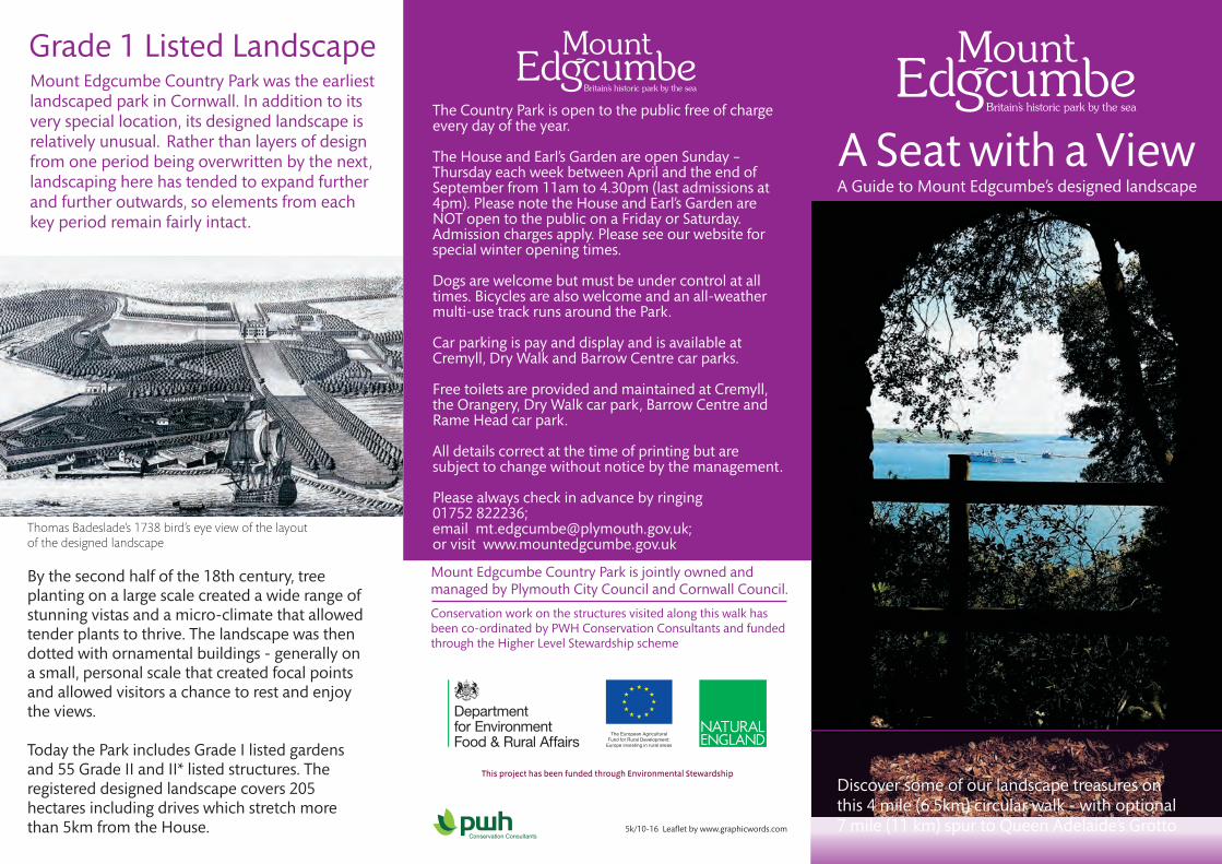
Grade 1 Listed Landscape
Thomas Badeslade’s 1738 bird’s eye view of the layout of the designed landscape
Discover some of our landscape treasures on this 4 mile (6.5km) circular walk - with optional7 mile (11 km) spur to Queen Adelaide’s Grotto
Conservation work on the structures visited along this walk hasbeen co-ordinated by PWH Conservation Consultants and fundedthrough the Higher Level Stewardship scheme
A Guide to Mount Edgcumbe’s designed landscape

Cremyll
HooeLakeValley
SchoolKingsand
Cawsand
FortPicklecombe
To Tregantle Fort
Cremyll Ferry
Polhawn Cove
RAME HEAD
RameChurch
RameQueen Adelaide’sGrotto
PenleePoint
Pier Cellars
Hooe Lake Point
B3247
WHITSAND BAY
MILLBRO
OK LAKE
B3247
HAMOAZE
River Tamar
Raveness Point
Redding Point
PLYMOUTH SOUND
PicklecombeSeatPicklecombeSeat
The Folly Milton’sTemple
WestLodge
Barn Pool
MakerChurch
Maker Entrance
CoachEntrance
Chapel
EddystoneLighthouse
Earl’s Drive
ClarrickWoods
St Julian’sWell
Empacombe
Old Windmill
Obelisk
FormalGardens Lower Park
TheBattery
The Avenue
Cremyll Shop& Children’sAdventurePlay Area
The Barrow Park Centre;
Café and ShopEarl’s Drive
DrywalkCar Park
Ice House
Red Seat
UpperDeerHouse
Deer Park
Lady Emma’sCottageLady Emma’sCottage
The Amphitheatre
The Orangery
MillbrookCAWSAND BAY
The Amphitheatre
Mount Edgcumbe House and
Earl’s Garden
Mount Edgcumbe House and
Earl’s Garden
HarbourViewSeat
KEYHistoric Landscape WalkOptional spur (3½ miles)Country ParkFootpathsMulti-use TrailPark Roads (no public access)Main access roadsLocal roads
Car parks CaféToilets Disabled access
P
P
P
P
UpperDeerHouse
HarbourViewSeat
Ice House
LowerDeer House
St Julian’sWell
Milton’sTemple
ZigZags
ZigZags
P
Start & Finish
Min
adew
Bra
kes
P
P
MainEntrance
Deer Park
StoneSeatStoneSeat
LowerDeer House
MakerBattery
Red Seat
Grotton PlantationGrotton Plantation
Empacombe
thBy the end of the 18 century visitors were flocking to Mount Edgcumbe to appreciate the stunning landscape. Across the centuries, the Edgcumbe family built a range of structures throughout the estate, which today reflect the development of the estate and phases of landscape design.
walk visits some of these structures which have recently been conserved and consolidated, using traditional materials, to preserve them for future generations. The work has been undertaken through a Higher Level Stewardship agreement. (More details about each of the features visited is given inside this leaflet.)
Along the route of the walk, you will discover:
The 4 mile (6.5km) circular historic landscape
The walk starts and finishes at the Barrow Park Centre, named after the nearby Bronze Age burial mound which was possibly extended as a
thviewing platform in the 16 century.
1 The Ice House
2 Milton’s Temple
3 The Red Seat
4 The Zig Zags
5 The Picklecombe Seat
6 Queen Adelaide’s Grotto (This is reached by a 3 ½ mile (5.5km) long spur, following the route of the Earl’s Drive, off the circular route)
Historic Landscape Walk
7
8
9
10
11
The Stone Seat
Upper Deer House
The Harbour View Seat
St Julian’s Well & Fountain
Lower Deer House
P

The Viaduct & The Ice House1In an unusual combination, the Viaduct which carries the drive across the terrace to the front of the House is also the entrance to the Ice House. The viaduct has parapets of cast iron with
To the east side of the Amphitheatre valley you will find this circular temple in the Ionic style, thought to have been built in1755. It is inscribed with a quotation from Book IV of John Milton’s “Paradise Lost”- “...Over head up grew insuperable heights of lofty shade... a woody theatre of stateliest view!”. The pastoral landscape here was achieved by landscaping in the early 19th century, providing an association with
Passing in front of the House, follow the park road down to Barn Pool and into the Amphitheatre.
2 Milton’s Temple Leaving the Amphitheatre, follow the path south up a steep incline intothe coastal woodlands and on past Lady Emma’s Cottage. Continue on the path to the Great Terrace and you will shortly reach...
Red Seat is a ruinous 19th century rest house at the top of the Zig-Zags. It was in place by 1869 and through the years has been known by a variety of names, including the Kiosk, Chinese Pagoda and the Indian Cottage. But there is some confusion with another structure, the Verandah, further down the slope - of which only the base remains.The Red Seat is a three-arched stone arcade and
3 The Red Seat
thUntil the mid-18 century, the area that became the Zig-Zags and Picklecombe was bare steep slopes running down to the sea. Then, around the 1750s, the Zig-Zag walks were created - intricate paths on a dramatic cliff, surrounded by exotic shrubs. Famed as “the Horrors” in the 18th and 19th century,
From the Red Seat, you can look down onto...
4 The Zig-Zags
the lower paths and some stone seats have since been lost in cliff falls. It is no longer possible to see the Zig-Zag paths below the Great Terrace, but the remains of the Upper Zig-Zags, created in the late 18th century, are visible above. Only a very short section remains passable, between the Red Seat and the Veranda, which have been restored for you to enjoy.
5 The Picklecombe Seat
Carefully walk down the only “Zig-Zag” remaining accessible, and rejoin the path heading west to find...
The seat dates to around 1779/80 and was constructed from a Medieval doorway, enclosing a small niche with a piscina at the back. The carved stone comes from the churches of St. George and St. Lawrence at Stonehouse.Here there would have been a view down the valley to the open sea, but in the 1860s the gun battery at Picklecombe was developed and extended with barracks.
At this point you have a choice - EITHER to follow the 7 mile (11km) “there and back” walk out to Queen Adelaide’s Grotto, OR to rejoin the path heading north west up the Hooe Lake Valley, and then follow the edge of the Grotton Plantation to the east to...
7 The Stone Seat
Also known as the Rock Seat or the Pebble Seat, it was originally an alcove seat offering fine views straight ahead, looking down the Picklecombe Valley to the sea. It was built from large, rounded stones, which have whitened over time. Only the base and around 3 to 4 feet of the curved rear wall survive. It is unknown how it was roofed. The Stone Seat is likely to date from the later 18th century, the time of many important landscape developments on the property.
9 The Harbour View SeatOnly the plinth and rear of this building remain, but it retains panoramic views which are very different from most other parts of the landscape, dominated by views of the river and not the sea. The building looks up the Tamar Valley, with the hills of Dartmoor beyond.
An earlier building on this site was probably used for signalling to shipping, and the first mention of an ornamental building here is in 1812. So the porticoed structure seen in the late 19th century photograph on the right may have been put up around 1810. It is likely that this was an earlier park building, dating to the 1750s or early 1760, moved to this location from elsewhere in the landscape.
10 St Julian’s Chapel and Holy Well
St Julian's Well is the oldest feature in this area, dating back to somewhere around the 14th to 15th centuries. A cistern inside the main chamber is fed by a spring. It is the oldest surviving of several structures at spring heads throughout the designed landscape.
Follow the road north until you reach the coach entrance to the park on your right. As you walk down the drive, on your right you pass the...
11 Lower Deer House
Although only a partial end wall and a few piers survive, this building played an essential role in the function of the park as a place to fodder and shelter the deer. The shed originally had five wide bays to front, divided by granite monolith piers, and eight bays to the rear. The suggestion that it pre-dates the
Continue down the path to FINISH back at the Barrow Park Centre - and enjoy some well-earned refreshments!
For the longer walk, follow the Earl’s Drive beyond the Picklecombe Seat and onwards across Minadew Brakes, through Kingsand and Cawsand and along Penlee Point to Queen Adelaide’s Grotto.
6 Queen Adelaide’s Grotto
Probably built in 1826-7 in advance of a visit from popular Queen Adelaide (wife of William IV) this is one of the most spectacular ornamental buildings. It is sited on the pivot point with views back to the core of the landscape of the deer park, and out to Rame Head.
View west to Rame Headfrom the Grotto
Built in picturesque Gothic style, it has a tunnel entrance to the left and a three sided chamber on the right, forming three gabled sides, each under a stone vaulted roof. A niche cut into the
From the Barrow Park Centre, follow the park road down towards the House and, where the road divides, turn right towards the House, where you will find... piers capped by vases and pineapples made of Coade
Stone. The Ice House, built in 1799, is a brick vault with chambers on either side. Ice and snow gathered in the
perishable food, cool drinks and prepare ice creams.winter was stored here for use in the summer to preserve
Milton’s paradise - and prompting some to suggest that the temple was notactually built until after 1810. The area was heavily affected by military activity during World War II i n p reparation f or D -Day.
Grade IIListed
Grade IIListed
Grade IIListed
Grade IIListed
Grade II*Listed
Grade IIListed
Grade II*Listed
rock at the back of the chamber may be the remains of an earlier cave used as a watch house.
Follow the perimeter of Grotton Plantation round the back andwestwards to the northern edge of the Deer Park to find...
8 Higher Deer House
Only the end walls and some of the piers that held up the roof remain of this two-storey fodder store for deer. This was a functional building rather than ornamental, and is thought to date from the 1750s when the new deer park in this area was being laid out.The earlier Tudor Deer Park - the origin of the Mount Edgcumbe estate - was created after 1515 on the lower, north-facing slopes. However, the herd was moved to allow the designed landscape to be developed and flourish.
Grade IIListed Grade II
Listed
Close by the Stone Seat within the Grotton Plantation are the remains of the...
START:
Continue on towards Maker Church and turn right there to head over to the B3247. On the bank by the roadside, you will find...
Higher Deer House and may be 16th century seems unlikely; it probably dates from the creation of the new Deer Park in the 1750s.
may have derived its name from the colour of paint used on its wooden superstructure, or perhaps because it lies above Redding Point.
winter was stored here for use in the summer to preserve
1833 engraving of the Grotto by Condy