Mount Cook - Civil Aviation Authority of New Zealand · The weather in the Mount Cook area can...
48
Mount Cook
Transcript of Mount Cook - Civil Aviation Authority of New Zealand · The weather in the Mount Cook area can...

Mount Cook

2
CONTENTS
Preflight Preparation .............................. 4
Documents ........................................ 4
Local Knowledge ................................ 5
Weather ................................................. 5
Wind ................................................ 5
Cloud ...............................................12
Lighting ...........................................13
Density Altitude ...............................16
Flying Techniques ..................................16
Human Performance ..............................19
Southern Alps Mandatory Broadcast Zone (MBZ) ............................................20
Altitude ...........................................21
Communications ..............................22
Other Collision Avoidance Measures .........................................25
Peak Traffic Times .............................25
Gliders .............................................25
Airline Traffic ...................................26
Parachute Operations ......................26
Environmental Policy ........................27
Visual Reporting Points – Scenic Flight ...28
Aerodrome Procedures ..........................40
Mount Cook Aerodrome ....................40
Glentanner Aerodrome .....................42
Tekapo Aerodrome ...........................44
Franz Josef Aerodrome ......................45
Fox Helipads ....................................45
Pukaki Aerodrome ...........................45
Summary ...............................................46
Every effort is made to ensure that the information in this booklet is accurate and up to date at the time of publishing, but numerous changes can occur with time, especially in regard to airspace and legislation. Readers are reminded to obtain appropriate up-to-date information.
CAA Web Site
See the CAA web site for Civil Aviation Rules, Advisory Circulars, Airworthiness Directives, forms, and more safety publications.
3
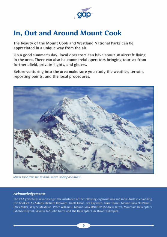
In, Out and Around Mount CookThe beauty of the Mount Cook and Westland National Parks can be appreciated in a unique way from the air.
On a good summer’s day, local operators can have about 30 aircraft flying in the area. There can also be commercial operators bringing tourists from further afield, private flights, and gliders.
Before venturing into the area make sure you study the weather, terrain, reporting points, and the local procedures.
AcknowledgementsThe CAA gratefully acknowledges the assistance of the following organisations and individuals in compiling this booklet: Air Safaris (Richard Rayward, Geoff Ensor, Tim Rayward, Fraser Dore), Mount Cook Ski Planes (Alex Miller, Wayne McMillan, Peter Williams), Mount Cook UNICOM (Andrew Yates), Mountain Helicopters (Michael Glynn), Skydive NZ (John Kerr), and The Helicopter Line (Grant Gillespie).
Mount Cook from the Tasman Glacier looking northwest.
3
4
Preflight Preparation
Thorough preflight preparation is the first step to a safe flight in the Mount Cook area. It is important, therefore, to spend time studying the relevant charts and sections of AIP New Zealand Vol 4. Reading the most up-to-date NOTAMS and AIP Supplement should alert you to any changes. Remember, it is your responsibility as pilot-in-command, to obtain this information before getting airborne.
Documents
Charts
It is important that you have the appropriate up-to-date area Visual Navigation Chart (VNC). Airspace can change, and does – many airspace incidents are caused by pilots referring to out-of-date charts. VNCs are available from Aeronautical Information
Management (AIM), www.aipshop.co.nz, or your local flight training organisation.
Refer to the most up-to-date AIP Supplement for a list of current VNCs.
AIP New Zealand Vol 4Information regarding the various aero-dromes in the Mount Cook/Westland area is promulgated in the AIP New Zealand Vol 4 AD section. Further essential information for making a safe flight through the Southern Alps MBZ (B978) is found in AIP New Zealand ENR 1.16, para 1.9.
Many of the aerodromes in the area require permission from the operator before you can use them, and contact details are provided on the aerodrome chart. Contacting the operator will, in most cases, give you the opportunity to ask about local weather conditions and obtain detailed information on arrival and departure procedures, or other special procedures for using the aerodrome.
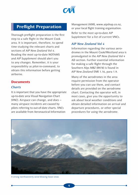
A strong northwesterly wind blowing loose snow.

5
Local KnowledgeIf you are new to flying in the Mount Cook area, we suggest that you ask a pilot with experience of the area to brief you on what to expect. If such a person is not readily to hand, a call to a local operator in the Mount Cook area would be worthwhile. They are happy to give you advice on the weather and actual or likely conditions in the area, but don’t expect them to make the go/no-go decision for you.
Weather
The weather in the Mount Cook area can change rapidly. It is important, therefore, to study the weather forecast carefully. Examine the general weather situation and the appropriate area reports and forecasts. These can be obtained from the Metflight GA web site, http://metflight.metra.co.nz. This web site provides forecast wind strengths and directions, at 1000, 3000, 5000, 7000 and 9000 feet. It is important to assess the wind direction and strength carefully, as it will provide an indication of the expected flight conditions (eg, turbulence). Remember to check for any SIGMETs. Additionally, seek local weather knowledge by contacting the local operators to augment these reports.
Ideally, a flight into the Southern Alps should be in anticyclonic conditions, which generally result in clear skies and light wind. You are more likely to encounter anticyclonic conditions in late summer and autumn.
Winter anticyclones can create smooth flying conditions, as very little turbulence exists (limited thermal activity) due to the stable cold air. Aircraft performance is also better in the cooler conditions. In the early morning, however, fog and low-lying stratus may occur in sheltered valleys. Caution is necessary during winter, as conditions can change very quickly.
The most variable weather conditions occur during spring and early summer, as there can be frequent frontal activity and unstable conditions.
WindIn calm and clear conditions, it is possible to fly comfortably throughout the Southern Alps. Calm days are not common, however, most flights will experience some wind. There can also be clear conditions with apparently light winds, yet in the lee of the mountains, moderate or severe turbulence can occur at altitude, especially in south-easterly and southwesterly conditions.
If the wind at operating levels is less than 15 knots, flying conditions are generally predictable and comfortable. As the wind strength increases beyond 15 knots, the predictability of wind patterns, flying conditions, turbulence, lift, sink, and windshear becomes more difficult. Think about the behaviour of a familiar river with varying flow speeds and obstacles to the currents.
The effect of wind on your flight will vary
depending on its strength and direction.

6
West and Northwesterly Winds
The most prevalent wind direction in the region is westerly (refer to Figure 1). As a broad generalisation, flying conditions will be smooth on the western upwind side of the Alps (green area) and turbulent on the eastern lee side (red area).
Westerly winds also lead to mountain wave development on the lee side of the Main Divide between 11,000 and 15,000 feet, often indicated by lenticular (lens-shaped) cloud.
Although the clouds appear to be stationary, in reality they are continuously forming on the upwind side and dissipating on the leeward side. Generally, smooth strong updraughts can be found on the windward side of these clouds. On the
leeward side of these clouds the air is descending as quickly as the air on the windward side is rising. These descent rates may be too great for passenger comfort. There may also be severe turbulence, indicated if the leeward side is ragged.
Unless you are well trained and experienced, it is advisable to vacate the area if lenticular cloud and rotors begin to form.
In northwesterly conditions, the wind can flow down some of the larger valleys, such as the Godley Valley. This can make it difficult to predict the wind flow at the junction of valley systems – such as the Malte Brun reporting point, where the wind flowing down the Tasman Glacier mixes with the Murchison Glacier wind.
Deteriorating weather at Mount Cook aerodrome in northwesterly conditions ahead of a cold front. On the West Coast,
rain associated with cumuliform cloud is spilling over into the head of the Tasman Glacier.

7
Figure 1: Green areas indicate expected smoother conditions if operating at higher altitudes (above 10,000
feet) in northwesterly conditions. Red areas indicate areas of expected turbulence. The blue arrows indicate the
approximate flow of air at lower altitudes during northwesterly conditions. Chart not for operational use.
Northwesterly Conditions

8
Southwesterly Winds
Southwesterly winds provide the most unpleasant flying conditions (refer to Figure 2).
Below 15 knots, they are no more than a nuisance, but stronger winds create rough and unpredictable flight conditions, as they tend to flow across the ranges and the valleys near the Main Divide. Extensive windshear will occur at all levels, as southwesterly winds produce unpleasant conditions on the lee side of the ranges. This same wind is also deflected along the western side, causing unpleasant conditions there as well.
The best general advice is to fly above 10,000 feet, adopting a flight path that is west of the glaciers on the West Coast and to the south of the larger peaks where possible. Avoid flight around the Divide, or around the upper sections of the Fox and Franz Josef Glacier snowfields.
It is advisable to avoid flying in the areas highlighted yellow or red during south-westerly conditions (Figure 2) unless experienced to do so.
A forecast indicating significant southwesterly wind is a good reason to postpone the flight for another day – especially for those inexperienced in the area and hoping for an enjoyable scenic experience.
Southerly Winds
Southerlies can produce varying conditions. In light winds, flying at any level may be turbulent in localised areas. If the southerly wind is above 15 knots, it flows along the Main Divide, making it almost impossible to find smooth flight conditions near the Divide on either side. In very strong southerlies, it is best to remain south of the higher peaks. Windshear is possible at lower levels in the wider valleys, as the wind will be lighter and blow up the valley, whereas at high levels it may be considerably stronger.
North and Northeasterly Winds
Northerly and northeasterly winds are not common in the Mount Cook area, and when they do occur, they rarely blow as strongly as westerlies and southerlies. Of all the wind directions, northerlies generally provide the smoothest flying conditions. Lumpy conditions will occur in localised areas, such as the lee of Mount Cook and other larger peaks, and in the head of the Tasman and Murchison valleys. They do not normally provide difficulties for over-flights.

9
Figure 2: Moderate turbulence may occur in the yellow area, and severe turbulence, with windshear at all levels
may occur in the red areas in strong southwesterly winds. The red arrows indicate the wind direction at higher
altitudes; the blue arrows indicate the wind direction at lower altitudes. Chart not for operational use.
Southwesterly Conditions
10
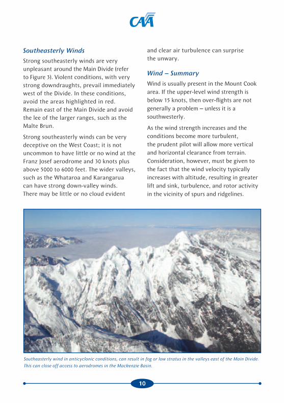
Southeasterly Winds
Strong southeasterly winds are very unpleasant around the Main Divide (refer to Figure 3). Violent conditions, with very strong downdraughts, prevail immediately west of the Divide. In these conditions, avoid the areas highlighted in red. Remain east of the Main Divide and avoid the lee of the larger ranges, such as the Malte Brun.
Strong southeasterly winds can be very deceptive on the West Coast; it is not uncommon to have little or no wind at the Franz Josef aerodrome and 30 knots plus above 5000 to 6000 feet. The wider valleys, such as the Whataroa and Karangarua can have strong down-valley winds. There may be little or no cloud evident
and clear air turbulence can surprise the unwary.
Wind – Summary
Wind is usually present in the Mount Cook area. If the upper-level wind strength is below 15 knots, then over-flights are not generally a problem – unless it is a southwesterly.
As the wind strength increases and the conditions become more turbulent, the prudent pilot will allow more vertical and horizontal clearance from terrain. Consideration, however, must be given to the fact that the wind velocity typically increases with altitude, resulting in greater lift and sink, turbulence, and rotor activity in the vicinity of spurs and ridgelines.
Southeasterly wind in anticyclonic conditions, can result in fog or low stratus in the valleys east of the Main Divide.
This can close off access to aerodromes in the Mackenzie Basin.

11
Figure 3: Strong downdraughts can occur at higher altitudes just west of the Main Divide (red areas), during strong
southeasterly conditions. The green areas indicate smoother conditions but localised turbulence can be expected at
lower altitudes. Blue arrows indicate strong down valley winds. Chart not for operational use.
Southeasterly Conditions

12
Cloud
Weather conditions in the area can change rapidly, and cloud can form quickly. A slight decrease in temperature towards the dew point can produce almost instant cloud.
Cloud is generally more of a problem for operations on the West Coast especially in westerly and northwesterly conditions before the arrival of a cold front. The westerly wind produces extensive stratiform and, depending on wind strength, cumuliform cloud along the western side of the Southern Alps. Initially the cloud tops are not high, and the heads of the valleys will be clear. There will be an increase in the vertical
development as the wind strength increases. The cloud also develops in the heads of the valley and eventually spills over to the eastern side.
The rapidity of cloud buildup along the western side of the Southern Alps in westerly conditions, can make it impossible to cross the Main Divide from the West Coast. If approaching the Divide from the east, conditions will be relatively clear but turbulent. In strong northwesterlies it may be impossible to cross the Divide, as it is very deceptive how far the down-flowing air can extend from the Divide.
During summer months, the development of a sea breeze can result in the formation
Stratocumulus cloud can quickly change into towering cumulus, especially in the afternoon during summer.

13
of cloud against the western foothills. This can develop further, with towering cumulus cloud in the early afternoon. These summer afternoon build-ups occur typically around the icefalls of the glaciers; they dissipate in the late afternoon, when the sea breeze weakens. If the sea breeze is combined with a westerly flow, then the afternoon build-ups will spread to the Divide.
East of the Main Divide, stratiform cloud can be a problem. For example, during winter in anticyclonic conditions, fog can occur throughout the Mackenzie Basin, which may persist until late morning or for a few days. Easterly winds can fill the valleys with stratus. This can result in shelving glacier cloud, which makes descent down a valley impossible, even if the head of the valley is clear. In light easterly conditions the heads of the valleys will be clear.
When a cold front comes through the weather changes very rapidly. It is not uncommon for a calm clear day to suddenly become one in which the valleys are completely clouded in.
Caution is required crossing the Main Divide, as typically one side of the Southern Alps will be clear, while the other is cloudy. In easterly conditions, the West Coast is generally clear. The east can be cloudy with clear skies in the heads of the valley. In northwesterly and westerly conditions, the opposite occurs. East of the Main Divide will usually be clear, except when the air is unstable. Significant cloud build-ups will then occur
along the ridges of the major valleys. West of the Divide, the amount of cloud will vary depending on the strength of the wind.
In both situations, remain high enough to glide clear of cloud in the event of an engine failure.
Changes in wind direction need to be observed carefully, as they can quickly lead to the formation of low cloud that may cut off access to some of the aerodromes.
LightingDifferent lighting conditions can create definition and depth-perception problems in the mountains.
The position of the sun can cause areas of deep shadow, into which it is difficult or even impossible to see. This is especially so in valleys. This shadow can occur in the early morning or late in the day when the sun is low on the horizon, and it is more marked in winter. In snow-covered areas there is flatter, harder lighting in the middle of the day, and depth perception is compromised.

14
Whiteout
There is always a lack of definition on snow surfaces, but this deteriorates very quickly when sunlight becomes diffused. When a large unbroken expanse of snow has the direct light reduced by an overcast sky, it blots out all trace of surface texture or shadows, including disguising gradient. It merges hollows and snow-covered objects into a flattened white background. Also, cloud and sky have the same apparent colour, so horizon discrimination is lost and the face of the ground disappears. It becomes impossible to judge height and distance. It also becomes impossible to see any patches of lower cloud.
The most important principle for flying in snow areas is that you progress according to what you can see. The worst trap is attempting to proceed because there appears to be nothing ahead; this is the classic feature of whiteout conditions –
the seeming void ahead and below.
The worst areas are those of total snow cover, such as the upper névé areas of glaciers, and other areas immediately after heavy snowfalls.
Whiteout conditions are likely to be encountered when operating up glaciers below a solid cloud ceiling. In the lower sections of the valleys, there is nearly always plenty of rock, tussock, or shingle to provide good terrain
perception. Further up towards the head of the glacier, pilots must be alert to possible whiteout conditions and must turn back down the valley before the safe visual cues start to disappear.
Contrast
An illusion of contrast occurs when dark-coloured rocks or ridges are visible above the snow. This illusion can deceive a pilot by giving the impression that good contrast conditions exist, when in fact it is still difficult to estimate the aircraft’s current height above the ground.
Brightout
In snow-covered areas, brightout occurs with a clear sky and bright overhead sunlight conditions. No shadows are cast because of the bright reflection from the snow. This can give a false representation of what you are flying over, and it can
The sun can cause areas of deep shadow, especially in valleys, into which it is
difficult, or even imposible to see. This can occur in the early morning, or late
in the day when the sun is low on the horizon, and is more marked in winter.

15
cause partial disorientation. There is virtually no visible definition and, as a result, hummocks and ridges will appear flat on unmarked snow.
Common Illusions
Relative scale
When flying among large mountains, it is very difficult to judge scale and distance accurately. Mountains seem a lot closer than they actually are, simply because they are so much larger than you.
The only way to confirm your distance from the terrain is by selecting features on the surface that you can judge the size of, such as tussocks, trees, or bush. It is important to be able to judge your distance from the terrain. Always leave yourself sufficient room to turn away from terrain.
Hidden obstacles
A common perception problem that pilots should be constantly aware of is the tendency for snow-covered faces and ridges to merge. Mountain faces in the distance, with a mix of rock and snow, can very easily mask the presence of a much nearer ridgeline of rock and snow. This can also occur with bush or tussock-covered hill faces and ridges.
The classic situation is when the aircraft is climbing towards a
mountain range a few miles away that is slightly higher than the aircraft, when an intervening ridge of similar snow cover merges visually with the more distant face. Because there is very little relative movement between the two ridgelines, and poor distance perception with featureless snow-covered terrain, the nearer face can be mistaken for part of the more distant face.
The same effect can occur when following the side of a snow-covered valley where ridgelines extend out from the main valley profile. It is very important to maintain good visual contact with the bases of approaching ridges and with valley profiles, so that a complete picture of the terrain ahead is correctly perceived.
The situation is more pronounced in overcast or shadow, but it can still be a problem in full sunshine.
Mountain faces in the distance, with a mix of rock and snow, can very easily
mask the presence of a much nearer ridgeline of rock and snow merging.
Can you identify the ridgeline?

16
During a turn, the steepness of an adjacent slope may be difficult to judge and incorrect assessment of this can cause difficulty.
In summary, many of the illusions can be overcome by flying with sufficient terrain clearance to ensure that the effect of visual illusions is reduced.
Flying Techniques
The Mountain Flying GAP booklet and Mountain Flying DVD contain a lot of useful information, but there is no substitute for practical mountain flying training with an appropriately qualified instructor.
Flying in the Mount Cook area involves slightly different mountain flying skills because of the particularly high elevation of the terrain. The reduction in aircraft performance may mean that manoeuvres that were possible at lower altitudes, become impossible at higher altitudes.
In the Mount Cook area, flying ‘high and wide’ can often be a prudent policy for comfort and safety because of terrain and traffic. This principle, however, is not applicable to all mountain flying circumstances, for example valley flying.
Ensure you are familiar with the height of the mountains and passes in the area. It may be prudent to revise, with your instructor, performance aspects of flying at higher altitudes.
False horizons
The frequent lack of a defined external horizon can create aircraft attitude and airspeed problems if the pilot is not aware of the possible illusions. When flying among the mountains, or anywhere the horizon is not visible, the pilot must visualise where the horizon is, or superimpose this imaginary horizon on the variable background. Remember, the horizon is where the sea meets the sky, and in the mountains it needs to be visualised as if the terrain was transparent.
Density Altitude At times, density altitude will differ substantially from the actual elevation and affect aircraft performance.
High temperature, low atmospheric pressure, and high humidity all result in a decrease in air density and an increase in density altitude. Aircraft performance, especially climb performance, is reduced in this situation.
Spend time reviewing the performance section in the flight manual to work out takeoff distances and expected climb performance in the given conditions.
For more information refer to the Takeoff and Landing Performance and Helicopter Performance GAP booklets.
17
Ridge Crossing
When crossing a saddle or pass, always cross at an angle to allow for an escape route if needed. Try to approach the saddle at an angle of 45 degrees, as it will allow you time to turn down and away, with only a minimum angle of bank. In windy conditions, approach the saddle at a higher altitude.
If flying straight and level towards a saddle or ridge and the visible terrain beyond the saddle increases, you are higher than the saddle. If straight and level and the visible terrain beyond the saddle becomes less, then you are lower than the saddle. If you are not flying straight and level, this parallax judgement is made extremely difficult.
Valley Flying
The normal recommended valley flying technique is to fly on the lift side of a valley. This puts the aircraft in smoother, updraughting air. If a 180-degree turn becomes necessary, it is made into the wind, requiring less distance over the ground. Bear in mind that downdraughts may be encountered on the lee side of the valley.
When flying in valley systems in high-density traffic areas, however, keep right. This standard is adopted in all major valley systems of the Southern Alps. If for any reason, such as turbulence or down-draughting air, it becomes necessary to depart from the standard traffic flow, then this must be highlighted in position reports.
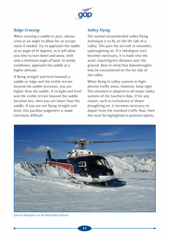
Squirrel Helicopter on the Richardson Glacier.

18
Remember that the wind strength and direction in a valley can vary markedly with height. At low levels the wind may blow down a valley – nearer the tops of the ridges it may be across the valley.
Know in advance whether the valley climbs and what altitude you will need to clear the pass or ridge at the end. Never attempt to fly up or down a glacial valley under a cloud layer – even if you can see it is clear at the head of the glacier. There are two problems. First, the cloud often shelves down along the contour of the glacier. More importantly, the slope of the glacier may exceed the climb performance capabilities of your aircraft.
Always position yourself in a valley so that you will have enough room to turn around if necessary. In narrow valleys, commit to one side or the other, preferably the righthand side. The only exception to this is when you are in a large valley where turning radius is not an issue – in this case anywhere right-of-centre is appropriate.
If in doubt, use the old topdressing adage, “never fly up a valley you haven’t previously flown down”.
Escape Routes
The golden rule of mountain flying is always to have an escape route. The aircraft must never be placed in a situation where there is insufficient room to turn back safely, to recover from an encounter with turbulence or downdraught, or to make a successful forced landing in the event of an engine failure.
Never enter a narrow valley without being certain that there is an escape route available.
Emergencies
In the event of unsatisfactory aircraft performance, there are plenty of aerodromes in the Mount Cook area to choose from.
In the event of an engine failure, in calm conditions it may be possible, if flying above 10,000 feet around the Divide, to glide back to Mount Cook or Franz Josef aerodrome. If flying above the snowfields, in wind, the only option may be a landing on the Franz Josef or Fox névés, rather than stretching the glide over inhospitable terrain to lower areas.
Snow being blown can be useful in determining wind strength and direction.
If flying in the lower sections of the major valleys, set the aircraft up for a landing on the valley floor. Assess the smoothest and most extensive looking areas of uniform shingle surface, or even a straight length of a 4WD track of sufficient length. Position into the valley wind and avoid

19
Hypoxia can be very subtle in its onset. Because the brain is not working properly, it may take some time before the pilot recognises the problem. Obviously this can be very dangerous, especially where the symptoms can result in a feeling of wellbeing combined with poor judgement and a loss of self-assessment.
In New Zealand, flight between 10,000 and 13,000 feet is allowed for a maximum of 30 minutes without oxygen. If you plan on taking advantage of this, be alert to the dangers of hypoxia.
Other Considerations
Flying in turbulence will add to your fatigue and may possibly nauseate you. Don’t put yourself in a position of trying to fly while fighting off airsickness.
When flying at higher altitudes, the air is drier, so be aware of the dangers of dehydration on longer flights. Carry water bottles so that you can monitor how much you drink. A good rule of thumb is for every one hour of flight time, aim to drink at least half a litre of water.
Glare is also greater at higher altitudes as there are less atmospheric pollutants, and reflections off cloud and snow-covered terrain are strong. Wear a good pair of aviation sunglasses.
With the cooler air at higher altitudes, the use of cabin heat is more likely. Check your carbon monoxide detector regularly. It is advisable to dress warmly, just in case the cabin heat fails. Even in summer, carry warm clothing and appropriate survival equipment. For more information see the Survival GAP booklet.
areas with streams cutting across them or with banks, gullies, or old watercourses.
If cloud is present on one side of the Divide, try to fly sufficiently close to the Divide to ensure that a glide could be made back to a clear area.
Make your MAYDAY call early to ensure VHF communication is possible. Make the emergency call on 118.6 MHz and, if time permits, on the appropriate Christchurch Information frequency.
The safety DVD Mountain Survival covers many aspects of surviving in inhospitable mountain terrain, including ways to utilise the aircraft fuselage for shelter.
Human Performance
Workload
A high cockpit workload, resulting from the requirement for greater than normal navigational accuracy and a constant lookout for other aircraft, can result in reduced mental capacity to make decisions and handle new tasks or problems. Careful preflight study of the VNC to obtain a mental picture of the area will help.
Hypoxia
At higher altitudes, lack of oxygen can cause hypoxia. Below 10,000 feet a healthy pilot should not be affected significantly by hypoxia. If the pilot is unwell, however, or a smoker, they will be more susceptible to hypoxia. Even at heights of 5000 to 8000 feet, the brain will generally not work as efficiently as it does at sea level.

20
On the western side, fixed-wing aircraft operate from several airstrips near the townships of Fox Glacier and Franz Josef Glacier. There are also numerous helipads in both these localities. These are just inside the western and northern boundaries of the MBZ. A parachute landing area is located about 5 NM west of the Fox Heliport.
Not all the West Coast aerodromes and heliports are featured on the VNC. Pilots can be misled into believing they are travelling through an isolated wilderness area with very little traffic – wrong!
Southern Alps Mandatory Broadcast Zone.
Keep a cloth handy for demisting the cabin windows in case the defrosting system does not work properly.
When flying at higher altitudes it is not uncommon for the air temperature to be around zero. It is advisable in this situation to use the pitot heat.
For further considerations refer to the Winter Flying GAP booklet.
Southern Alps Mandatory Broadcast
Zone (MBZ)
The Southern Alps MBZ encompasses an area including Lake Tekapo, Glentanner Park, and the Mount Cook and Westland National Parks. Refer to the Mount Cook 1:250 000 VNC.
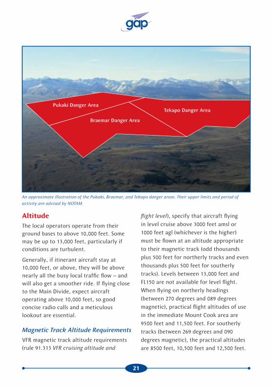
Danger Areas, D926, D927, and D928, between Lakes Pukaki and Tekapo are used for live firing practice by the Army. For both areas, the upper limit and period of activity are advised by NOTAM. If in doubt, plan to avoid them – or risk being shot at!
On the eastern side, the area includes the private aerodromes of Mount Cook, Glentanner, and Tekapo – all require prior approval for use. There are also a number of helipads in the area.
21
AltitudeThe local operators operate from their ground bases to above 10,000 feet. Some may be up to 13,000 feet, particularly if conditions are turbulent.
Generally, if itinerant aircraft stay at 10,000 feet, or above, they will be above nearly all the busy local traffic flow – and will also get a smoother ride. If flying close to the Main Divide, expect aircraft operating above 10,000 feet, so good concise radio calls and a meticulous lookout are essential.
Magnetic Track Altitude Requirements
VFR magnetic track altitude requirements (rule 91.313 VFR cruising altitude and
An approximate illustration of the Pukaki, Braemar, and Tekapo danger areas. Their upper limits and period of
activity are advised by NOTAM.
flight level), specify that aircraft flying in level cruise above 3000 feet amsl or 1000 feet agl (whichever is the higher) must be flown at an altitude appropriate to their magnetic track (odd thousands plus 500 feet for northerly tracks and even thousands plus 500 feet for southerly tracks). Levels between 13,000 feet and FL150 are not available for level flight. When flying on northerly headings (between 270 degrees and 089 degrees magnetic), practical flight altitudes of use in the immediate Mount Cook area are 9500 feet and 11,500 feet. For southerly tracks (between 269 degrees and 090 degrees magnetic), the practical altitudes are 8500 feet, 10,500 feet and 12,500 feet.
Braemar Danger Area
Tekapo Danger AreaPukaki Danger Area

22
In some instances aircraft flying in this area can be within 1000 feet of the ground and the requirement would not apply. Local operators do not necessarily remain in level flight during the course of their scenic flights, so again the requirement would not apply. Nevertheless, for aircraft over-flying at higher altitudes, it would make good sense to fly at the appropriate magnetic track altitude, if terrain and weather considerations make this practical.
QNH Setting
The Ohau QNH zone covers the Mount Cook area. Refer to the QNH zones in AIP New Zealand ENR Figure 1.7-2. Within this area, pilots should use the Ohau QNH, which is available from Christchurch Information.
Use of the Ohau QNH on both sides of the Divide ensures common altitudes in position reports, even though the QNH can be several hectopascals (hPa) different on the West Coast side.
On some days this could result in up to 300 feet difference on the altimeter. Local West Coast pilots are aware of a possible discrepancy, but because they are flying visually, the inaccuracy in height above the terrain is accepted in favour of a common altitude measurement for all traffic.
Visiting aircraft should be flying at an altitude where the pressure differential (and resulting altitude error) will not be a problem. If you plan to land on the
West Coast, be aware of the possibility of error in height above terrain.
If on departure from an aerodrome, you are unable to contact Christchurch Information for an accurate QNH, set the aerodrome elevation on the altimeter. If possible when airborne, obtain the QNH from Christchurch Information before changing back to 118.6 MHz.
Communications
Christchurch Information
Christchurch Information is available on a variety of frequencies around the Mount Cook area (refer to the FISCOM chart in AIP New Zealand GEN Figure 3.4-3).
When flying west of the Main Divide, Christchurch Information is available on 118.5 MHz. Be aware that operating at lower altitudes or southwest of the Southern Alps MBZ, VHF coverage is unreliable.
When operating at low level over the Mackenzie Basin, Christchurch Information is available on 123.5 MHz. At higher levels and in the immediate area around the Southern Alps MBZ, Christchurch Information is available on 124.4 MHz or 122.2 MHz.
If you are unable to contact Christchurch Information on the primary frequency for the area, try a frequency that is adjacent to the area you are in.

23
Before Entering the MBZ
In the immediate Mount Cook area, there is no controlled airspace. Position reports can be made to Christchurch Information. It is a good idea to give them a position report and obtain the Ohau QNH, before switching to 118.6 MHz and entering the Southern Alps MBZ.
In the MBZ
Some problems that local tourist flight operators encounter with itinerant pilots in the Mount Cook area are:
• incorrect position reporting
• insufficient number of radio calls
• no radio calls due to use of an incorrect frequency.
AIP New Zealand, ENR 1.16 para 1.9.6 stipulates that radio calls must be made when entering, and at least every 15 minutes within, the Southern Alps MBZ. It is possible, however, to transit the entire area in less than 15 minutes (depending on your aircraft type). Local operators, therefore, recommend that radio calls be made at 5 minute intervals. Especially when flying around busy areas such as the Main Divide, and joining at the various aerodromes or heliports with the MBZ. Keep these calls brief to minimise frequency jamming.
Within the MBZ, 118.6 MHz is primarily a collision avoidance frequency.
Frequency Jamming
Simultaneous calls on 118.6 MHz at peak times are a current concern in the area. They can result in multiple, and at times continuous, high-pitched radio interference. This occurs because a common frequency is used on both sides of the Divide. The pilots most affected by frequency jamming are those flying at greater altitude; they receive calls from both Mount Cook and Westland National Parks and from the Mackenzie Basin. Keep transmissions brief.
If a local aircraft calls you – please answer. They are more familiar with the area, and if they can establish where you are and what you plan to do, they can help the progress of your scenic flight. Because 118.6 MHz is a collision avoidance frequency, communication between pilots is acceptable and is encouraged if it will help avoid collisions.
Looking towards the Geikie Snowfield at the top of the Franz Josef Glacier.
24
When flying on the West Coast anywhere between Karangarua and Whataroa Rivers (these are distinctive features for reporting purposes), 118.6 MHz should be used, because you are in the let-down area for the airfields and helipads at Fox and Franz Josef. Make a radio call approaching the townships. If you follow the coastline you will generally be clear of this traffic.
If you are landing at any of the aerodromes in the area, keep your joining and circuit calls brief. At lower altitudes you will not hear (thus not be aware of) all the traffic on the frequency. A lengthy call could blot out transmissions vital to others trying to avoid collisions.
Reporting Position
If flying within valley systems or near the Main Divide, make a brief radio call stating position, altitude, direction of travel to the next reporting point, and whether you are climbing or descending – who, what, where. For example, “Alpha Bravo Charlie, Tasman Saddle, 9500 feet, west” or “Alpha Bravo Charlie, over the Geikie Snowfield, 9500 feet, descending west”.
You will probably hear local pilots giving unusual sounding position reports. You cannot expect to know all these obscure mountain passes, saddles, huts, etc, so do not be fazed – just give clear position, altitude and direction broadcasts in relation to major features or reporting points, and they will know where to look for you. If you stay high and clear of the Main Divide, you greatly reduce the likelihood of conflict with local traffic.
If you are unsure about the exact location of some of the reporting points, it is adequate to give reports using easily identifiable features, eg, head of the Godley, head of the Franz Josef Glacier or Fox Glacier. Use ‘halfway’ or ‘third’ if necessary for a position along the Tasman Glacier. Reporting “overhead Tasman Glacier” is not much use because of its length.
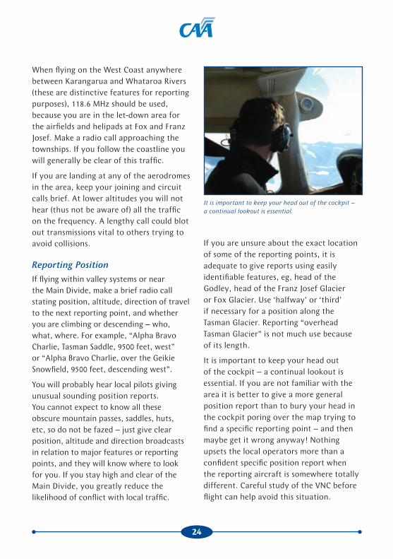
It is important to keep your head out of the cockpit – a continual lookout is essential. If you are not familiar with the area it is better to give a more general position report than to bury your head in the cockpit poring over the map trying to find a specific reporting point – and then maybe get it wrong anyway! Nothing upsets the local operators more than a confident specific position report when the reporting aircraft is somewhere totally different. Careful study of the VNC before flight can help avoid this situation.
It is important to keep your head out of the cockpit – a continual lookout is essential.

25
Other Collision Avoidance MeasuresWhen flying within the Southern Alps MBZ, landing and anti-collision lights must be used. When flying in the valley systems, stay on the righthand side where possible. If it is necessary, due to turbulence or downdraughts, to be on the lefthand side, radio calls should clearly state ‘non-standard’, when making position reports and advising intentions.
Peak Traffic TimesThe peak season for scenic flying in the Mount Cook area is from November to April. During this period, on a fine day, there can be 30 or more local aircraft operating in the area.
Peak operating times for tourist flight operators on the eastern side coincide with the arrival of bus tours and are generally between the hours of 10 am and 3 pm. Operators on the West Coast experience a different pattern. The buses usually arrive late in the day and depart early the next day, so most tourist flights take place late in the afternoon, or early in the morning. Helicopter traffic in the area between Fox and Franz Josef will be particularly busy during these times, and will be climbing to, and descending from, as high as 13,000 feet.
For a more relaxing and enjoyable time, visiting pilots should plan their flights outside of peak operating times. Other than the West Coast traffic mentioned above, there is generally less traffic and less cloud early in the day. Late in the day is also a good time. Note that on the first fine day after a bad spell of weather, traffic can be particularly busy.
GlidersBecause of the excellent soaring conditions in the Mount Cook area, and the proximity of a major world-class soaring centre at Omarama, gliders can be found anywhere in the area at any time. This is especially so during summer, with most of the activity taking place in the Dobson, Neumann, Ben Ohau, and Hopkins areas. These areas are on the western side of the MBZ.
Glider pilots will be on 118.6 MHz and will be making the same radio calls as powered aircraft.
Looking south from the Barron Saddle, down the Dobson River towards Lake Ohau. Gliding activity can take place along the Ben Ohau Range (on the left) and the Neumann Range (on the right).

26
Outside the MBZ, glider pilots may be on their own chat frequency (133.55 MHz) as they discuss where the best soaring conditions are to be found.
Remember, powered aircraft must give way to gliders – keep a good lookout for them.
Airline TrafficIn the future, it is likely there will be an increase in numbers of larger, high-speed aircraft operating into Mount Cook aerodrome.
For airline pilots unfamiliar or not current with the area, the Mount Cook User Group recommends that arrivals and departures at Mount Cook aerodrome be made from the south or southeast via Landslip Creek. Beware of aircraft flying between Glentanner and Tekapo.
For airline pilots who are more familiar with the local reporting points and geography, and who wish to include a scenic component in their flight before arriving at Mount Cook, the User Group recommends (weather permitting) that aircraft fly along the western side of the Main Divide above 11,000 feet until crossing the Divide, and descend south of Mount Cook. In the descent, the speed should be below 170 knots (or minimum safe manoeuvring speed) crossing the Mount Cook Hermitage at 9000 feet (due to noise abatement procedures) and not below 6000 feet over Round Hill due to helicopter operations joining and departing Glentanner.
Aircraft should track via Mount Cook Station to the aerodrome.
IFR traffic enters the area via the instrument approach for the Mount Mary VOR/DME, located to the east of Lake Pukaki. If aircraft are landing at Pukaki, the instrument approach is from the beacon southwest towards Pukaki aerodrome, and takes the aircraft down to a minimum of 3000 feet. If the traffic is joining for Glentanner or Mount Cook, it will descend down to 3500 feet at Tasman Downs and proceed VFR to the required aerodrome.
Parachute OperationsAt Fox Glacier aerodrome, the parachute drop aircraft may be very busy on a clear day. The aircraft departs from Fox climbing to the west towards Lake Matheson, before heading towards the Fox Glacier névé (9000 feet) and returning to overhead the parachute landing area at 12,000 feet. At this altitude, normally two parachute jumpers are released, who free fall down to 5000 feet, and are under canopy at 4000 feet. Normal position reports are
Looking west along the Fox River. The Fox parachute landing area is circled.

27
made during the climb and a final call as
the drop is made.
It is recommended that other aircraft
avoid flying within the landing zone when
parachute operations are in progress.
From Franz Josef aerodrome, parachute
drop aircraft initially climb to the west,
then turn east and climb towards the
Baumann Glacier, pass over the mid to
lower Franz Josef Icefall, then track west
to drop jumpers on the southern side of
Franz Josef Aerodrome, or 2 NM west of
the aerodrome. Drops can take place from
up to 18,000 feet.
Environmental PolicyIn order to reduce noise pollution and maximise enjoyment of the Mount Cook/
Round Hill looking north up the Tasman Glacier.
Westland area for other users of the Parks, local tourist flight operators have an agreement with the Department of Conservation to avoid certain areas. The summit and summit ridge of Aoraki/Mount Cook is one such area. Operators have also agreed to fly not below 6000 feet in the Hermitage area, and not below 8000 feet in the Mueller and Hooker valleys. It is expected that itinerant pilots will respect this agreement also.
Due to locally agreed noise abatement procedures, it is recommended that itinerant pilots landing at Franz Josef and Fox aerodromes approach from the west to avoid flying over the townships. Joining traffic should be vigilant for traffic operating from a small private airstrip located to the southeast of Franz Josef aerodrome.
Harper Saddle
Mount Cook
Hooker Glacier
Mount Haidinger
Graham Saddle
De la Beche RidgeMalte Brun
Corner
Malte Brun
Mount Elie De Beaumont
Murchison Glacier
Hooker Bridge
Tasman Terminal

28
Visual Reporting Points – Scenic Flight
It is recommended that you plan your scenic flight route before your flight. This allows you to study the reporting points, plan the necessary altitudes and the flight route. Be prepared, however, to change your flight route if weather and traffic conditions mean you need to do so.
Aircraft entering the MBZ for an over-flight generally enter via Lake Pukaki or Lake Tekapo from the south, Godley Valley or Burkes Pass from the east, Franz Josef from the north, or the Landsborough Valley from the west.
Fly on the righthand side of the Godley Valley (unless the wind dictates otherwise). Mount D’Archiac is a prominent reference point to fly towards.
In northwesterly conditions, the wind will be coming down the valley. Initiate an early climb to achieve 10,000 feet or above as soon as possible. The Head of Lake Tekapo is an easily identifiable point to make a radio call broadcasting your intentions. The Godley Valley remains relatively wide in the upper reaches and the Godley Lakes make another good reporting point.
Burkes Pass looking east. Burkes Pass is a common entry point into the Mackenzie Basin for aircraft arriving from the east.
Lake Pukaki looking north towards Main Divide of the Southern Alps.
Mount CookMount Sefton
Copland Pass Mount Tasman
Tasman Glacier
Mount Cook aerodrome
Rotten TommyRound Hill
Glentanner aerodrome
Lake Pukaki
Mount Cook Village
Mount Cook Station

29
Lake Mapourika looking south towards the Franz Josef Glacier and Mount Cook.
Upper Landsborough River, looking northeast along the Main Divide of the Southern Alps towards Mount Cook.
Lake Mapourika
Franz Josef township
Mount Cook
Waiho River
Franz Terminal
Franz Josef Glacier
Harper Saddle
Mount TasmanMount LendenfeldMount
Haidinger
Davis Snowfield
Mount Haast
Franz Josef helipads

30
At the end of the valley, crossing over into the upper Whataroa at 10,000 feet will ensure good terrain clearance. Expect a few bumps, and steer a wide path to the north of Mount Elie De Beaumont.
Be on the lookout for traffic crossing the Divide at this point. If you are planning to over-fly the glaciers, it may be necessary to climb above 10,000 feet to ensure vertical separation from scenic aircraft operations in the area. For ease of reporting and traffic avoidance, fly a wide path over the icefalls of the Franz Josef and Fox Glaciers and on to the West Ridge la Perouse. This will ensure separation from the scenic operations closer to the Divide.
Along the Divide there are plenty of passes to choose from, if you wish to cross back over to the Tasman or Hooker Valleys from
Head of Lake Tekapo looking north up the Godley River.
Looking down the Hooker Valley towards Mount Cook Village. Lake Pukaki is in the background.
Mount D’Archiac.
Lendenfeld Saddle looking southwest towards Mount Cook. The Lendenfeld Saddle is at the head of the Tasman Glacier. Mount Elie De Beaumont is on the right.
31
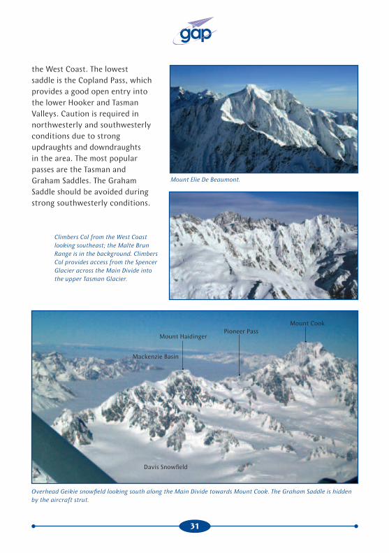
the West Coast. The lowest saddle is the Copland Pass, which provides a good open entry into the lower Hooker and Tasman Valleys. Caution is required in northwesterly and southwesterly conditions due to strong updraughts and downdraughts in the area. The most popular passes are the Tasman and Graham Saddles. The Graham Saddle should be avoided during strong southwesterly conditions.
Mount Elie De Beaumont.
Climbers Col from the West Coast looking southeast; the Malte Brun Range is in the background. Climbers Col provides access from the Spencer Glacier across the Main Divide into the upper Tasman Glacier.
Overhead Geikie snowfield looking south along the Main Divide towards Mount Cook. The Graham Saddle is hidden by the aircraft strut.
Mount CookPioneer Pass
Mount Haidinger
Davis Snowfield
Mackenzie Basin

32
Franz Josef Glacier looking east towards the Main Divide of the Southern Alps.
Looking west from the Main Divide down the Fox Glacier.
Mount CookMount Tasman
Mount HaastMount Haidinger
Graham Saddle
Davis Snowfield
Franz Josef Glacier
FRITZ RANGE
VICTORIA RANGE
Chancellor HutVictoria Flat
FOX RANGE
Victoria Gap

33
Looking east from the Fritz Range towards the Main Divide.
Looking east from the Victoria Range towards Mount Cook.
Mount Tasman
Pioneer PassClarke Saddle
Graham Saddle
Malte Brun
Climbers Col
Pioneer Hut
VICTORIA RANGE
FRITZ RANGE
Geikie Snowfield
VICTORIA RANGE
FOX RANGE
Mount CookHarper Saddle
West Ridge la PerouseMount Tasman
Clarke Saddle
Big Mac
Mount Haast
Pioneer Pass
Douglas Peak
Victoria Gap
Fox Glacier
Minarets
Mount Haidinger

34
(Left) Looking up the Fox Glacier. Note the difference in lighting between the valley and the névé of the Fox Glacier.
(Below) Overhead the Victoria Range looking southeast towards Mount Cook.
Big Mac
Pioneer PassMount Haast
Douglas Peak
Pioneer Hut
Victoria Gap
Chancellor Hut
Victoria FlatFox Glacier
Mount Cook
Mount TasmanClarke Saddle Harper Saddle
West Ridge la Perouse
Fox Glacier
Big Mac
Helicopter landing sites
35
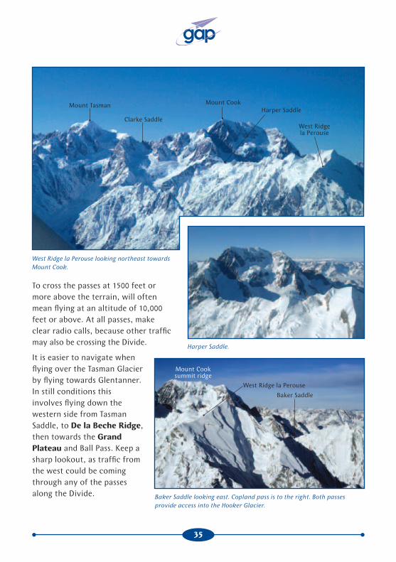
To cross the passes at 1500 feet or more above the terrain, will often mean flying at an altitude of 10,000 feet or above. At all passes, make clear radio calls, because other traffic may also be crossing the Divide.
West Ridge la Perouse looking northeast towards Mount Cook.
Harper Saddle.
Baker Saddle looking east. Copland pass is to the right. Both passes provide access into the Hooker Glacier.
Mount Tasman
Clarke Saddle
Mount CookHarper Saddle
West Ridge la Perouse
Mount Cook summit ridge
West Ridge la Perouse
Baker Saddle
It is easier to navigate when flying over the Tasman Glacier by flying towards Glentanner. In still conditions this involves flying down the western side from Tasman Saddle, to De la Beche Ridge, then towards the Grand Plateau and Ball Pass. Keep a sharp lookout, as traffic from the west could be coming through any of the passes along the Divide.

36
Copland Pass from the West Coast looking east towards the Burnett Mountains and the Mackenzie Basin.
Classen Saddle looking east down the Murchison Glacier.
The FootstoolCopland Pass
Mackenzie BasinBurnett Mountains
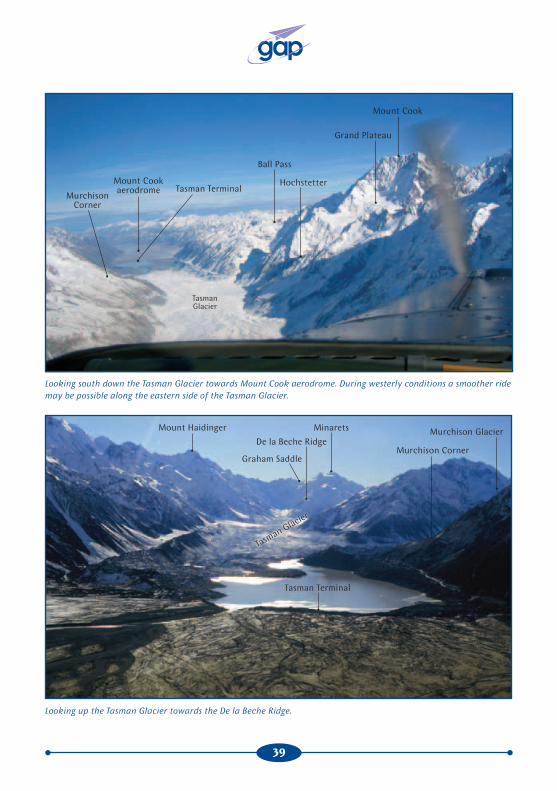
In typical westerly conditions, most of the traffic will fly down the eastern side of the Tasman Valley. In this situation it can be very busy, with climbing and descending traffic on the same side of the valley. For this reason, make regular radio calls, including changes in altitude, preceded by the words ‘non-standard’. Reporting points are: Darwin Corner, Beetham, Malte Brun Corner, and Tasman Terminal.

37
Mount Sefton looking southeast into the Mackenzie Basin. Note the southeasterly fog and low stratus in the Mackenzie Basin.
Mount Elie de Beaumont looking south down the Tasman Glacier towards Mount Cook.
Mount Cook
Tasman Glacier
Hochstetter
Beetham
Mount Tasman
Darwin Corner

38
The Tasman Glacier.
Tasman Glacier
Hochstetter Dome
Lendenfeld SaddleDarwin Corner
Beetham
39
Looking south down the Tasman Glacier towards Mount Cook aerodrome. During westerly conditions a smoother ride may be possible along the eastern side of the Tasman Glacier.
Looking up the Tasman Glacier towards the De la Beche Ridge.
Mount Cook
Grand Plateau
Hochstetter
Ball Pass
Mount Cook aerodrome Tasman Terminal
Murchison Corner
Tasman Glacier
Mount Haidinger
Graham Saddle
Minarets
Murchison Corner
Murchison GlacierDe la Beche Ridge
Tasman Terminal
Tasman Glacier

40
Aerodrome Procedures
When planning a flight, everything you need to know for each aerodrome should be found by studying AIP New Zealand Vol 4 and the VNCs. It is recommended that this information be studied carefully before your flight. Note that at each aerodrome, there may be additional local procedures that should be used in conjunction with the AIP New Zealand Vol 4 information. Permission is required to use most of the aerodromes in the area, and in most cases a briefing on local procedures will be given.
For operations at higher aerodrome elevations, be aware of the effect of density altitude on aircraft performance.
Mount Cook AerodromeMount Cook aerodrome is situated in the Tasman Valley. All aircraft landing or departing should make standard unattended radio calls on 118.6 MHz.
Arrivals
All aircraft joining should conform to the aerodrome traffic pattern.
If you are approaching from the south, watch out for helicopters departing or arriving from Glentanner. They can be climbing or descending on the eastern side of the Tasman River for the Gorilla reporting point.
Arriving from the north is more difficult, as it typically involves a descent from a higher altitude. Be aware of the ski-planes that will be joining from a high altitude.
Mount Cook aerodrome, looking northwest towards the Mount Cook village. Mount Sefton is in the background.

41
The wind can be extremely shifty at Mount Cook aerodrome, as it can swirl in the valley floor. During the winter months, strong katabatic airflows can flow down the Tasman Glacier, resulting in strong crosswind conditions on Runway 31. During westerly and northwesterly conditions, strong windshear can be experienced at low levels. Southerly airflows tend to blow up the valley.
Departure Procedures
It is recommended that itinerant aircraft use the full length of the active runway.
When taking off on Runway 31, note the rising terrain immediately to the northwest. After takeoff, it is advisable to make an early right turn (expect downdraughts in strong northwest conditions) aiming for Gorilla Stream in light northwest wind, or Rotten Tommy in stronger conditions.
If you are departing to the north, it may be necessary because of the proximity of the terrain to make a climbing orbit before proceeding up the Tasman or Murchison Valley.
Mount Cook aerodrome looking south towards Lake Pukaki.
Mount Cook aerodrome
Glentanner aerodrome

42
Glentanner Aerodrome
Glentanner is located at the head of Lake Pukaki. Due to the proximity of the aerodrome to the high terrain immediately west of the field, there is a higher meteorological minima, with a minimum ceiling of 1000 feet agl and 8 km visibility.
Arrival
Glentanner aerodrome can be busy with helicopter traffic and, to a lesser extent, fixed-wing traffic. If arriving in a fixed-wing aircraft, conducting an overhead join is advisable. The circuit pattern is out over the lake, and it is important to maintain
Downwind for Runway 33 at Glentanner. The aerodrome can be seen just behind the strut.
43
propeller clearance, as the grass taxiway is undulating. During winter months, the taxiway can also be soft.
Departure
Caution is required when lining up on the runway, as aircraft situated on the other end of the runway cannot be seen. All turns airborne are made out over the lake to avoid terrain. Be on the lookout for helicopter traffic arriving from the north or south.
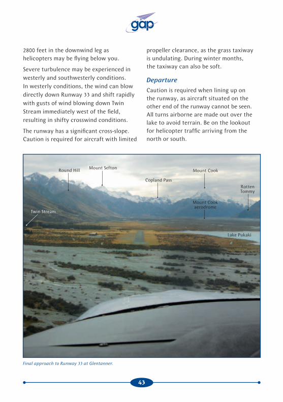
2800 feet in the downwind leg as helicopters may be flying below you.
Severe turbulence may be experienced in westerly and southwesterly conditions. In westerly conditions, the wind can blow directly down Runway 33 and shift rapidly with gusts of wind blowing down Twin Stream immediately west of the field, resulting in shifty crosswind conditions.
The runway has a significant cross-slope. Caution is required for aircraft with limited
Final approach to Runway 33 at Glentanner.
Mount Cook
Copland Pass
Mount SeftonRound Hill
Mount Cook aerodrome
Rotten Tommy
Lake Pukaki
Twin Stream

44
Tekapo AerodromeTekapo aerodrome is the highest aerodrome in the area, its elevation 2496 feet.
Arrival
If you are arriving from the Tasman Glacier, check the three danger areas to the northwest of the aerodrome. If the danger areas are active, it is safer to track down to Tasman Downs and then line up Lake Tekapo township in the distance. This should ensure that you pass safely to the south of the danger areas.
Watch out for Mackenzie Helipad, located 1.5 NM southwest of Tekapo Aerodrome. The AIP New Zealand plate for Mackenzie Helipad shows procedures to help avoid conflict with Tekapo Aerodrome circuit traffic.
The prevailing wind direction is generally from the west or the east. During summer, strong northerlies can occur resulting in strong crosswind conditions at the aerodrome. The runway is narrow with significant slope, Runway 11 sloping downhill and Runway 29 uphill.
Departure
It would be prudent to work out the takeoff performance for your aircraft, as a density altitude of 4000 feet is not uncommon during the summer months.
For noise abatement, when approaching or climbing to the north, avoid over-flying Lake Tekapo township.
Tekapo aerodrome looking northwest towards Lake Tekapo.
Lake Alexandrina
Mount JohnLake Tekapo
Lake Tekapo Township
Tekapo aerodrome

45
Franz Josef AerodromeFranz Josef aerodrome is within the Southern Alps MBZ on the West Coast. Intensive helicopter operations take place from helipads adjacent to Franz Josef township. It is recommended, due to traffic avoidance and noise abatement, that you join the aerodrome from the west. If descending from the snow-fields, descend to the northwest out beyond the Waiho River, to remain clear of parachute and helicopter traffic. Avoid flying over Franz Josef township. Watch out for aircraft activity at the airstrip located 2 NM south of the aerodrome, up against the southwest hills.
Fox Helipads Four helipads are located around the Fox township. For noise abatement, maintain at least 3000 feet in the vicinity of the Fox township and do not overfly the town.
Be alert to possible parachute operations. The parachute landing area is located 5 NM to the west of Fox Helipad. When joining, while parachuting operations are taking place, remain south of the Cook River or north of the Fox River.
Pukaki AerodromePukaki aerodrome is located just to the south of the MBZ, near Twizel.
Franz Josef aerodrome next to the Waiho River. The Franz Josef
township is in the background.
It is advisable to be listening out and making radio calls on 119.1 MHz if you are transiting through the area.
Pukaki aerodrome is an alternate for airline traffic when the weather is unsuitable at Mount Cook aerodrome.
Caution is required during spring and after rain as the grass may be soft during thaw.
Franz Josef helipads
Franz Josef aerodrome

46
Summary
By air, we are able to view a large area of majestic scenery in the Southern Alps in a limited amount of time and from a position of relative comfort. It is important, of course, to maintain this level of comfort by keeping a safe distance between the aircraft and the mountain slopes – and by avoiding close encounters with other aircraft in the area.
Remember:
• Plan your flight to accommodate the forecast weather.
• Avoid peak traffic times, if possible.
• If you have another pilot on board, have them assist you by tracking your position on the VNC.
• Use 118.6 MHz within the MBZ.
• Stay high and wide to avoid most of the traffic. (Your passengers will also have better photographic opportunities to take in the full majesty of the terrain.)
• Make position reports regularly. Keep them brief and as accurate as you can. For example, “Alpha Bravo Charlie, upper Tasman glacier, 10,200 feet, climbing west for Climber Col”.
• Fly on the righthand side of the valleys, unless the wind and turbulence dictate otherwise.
Before venturing into the Mount Cook and Westland National Parks, be suitably prepared. It is important that you have had adequate mountain flying training. Careful preflight planning is also essential, taking into account all of the aspects covered in this booklet.
Have a safe and enjoyable flight.
46

47

PO Box 3555Wellington 6140Tel: +64 4 560 9400Fax: +64 4 569 2024Email: [email protected]
In, Out and Around Mount Cook was was revised in October 2011.
See our web site, www.caa.govt.nz, for details of more safety publications.