
Morphostructural Development of Gunungsewu Karst, Jawa … 20130202.pdf · The orientations of the...
19
Indonesian Journal of Geology, Vol. 8 No. 2 June 2013: 75-93 75 Morphostructural Development of Gunungsewu Karst, Jawa Island Perkembangan Morfostruktur Kars Gunungsewu di Pulau Jawa H.D. TJIA Universiti Kebangsaan Malaysia (The National University of Malaysia) Bangi, Malaysia ABSTRACT Gunungsewu karst (also known as Sewu karst in the literature) is synonymous with morphology of a car- bonate terrain dominated by hills crowned by accordant-level tops that developed in a humid tropical environ- ment by comparatively more rapid dissolution and denudation. In addition, the hills are sinoid to cone-shaped. Surface drainage is negligible compared to subsurface water flow. Abandoned channel segments and spatial arrangements of karst hills have been found to correspond with fracture patterns that are genetically associ- ated with the regional compression direction of Jawa Island. Images derived from space platforms show many landform patterns that were neither known from ground-based nor from aerial photograph study. Landforms arranged in ring, multi-ring, spiral, polygonal, and long linear to serpentine patterns are common beside the expected depressions of dolines, poljes and uvalas. The orientations of the long linear ridges appear to change systematically from those near the coast to those located inland. These linear ridges are interpreted as deposi- tional fronts, most likely representing breaker zones. The youngest depositional ridge fronts, located nearest to the present shoreline, are parallel to the geological strike of Jawa Island. Toward the island’s interior, linear depositional fronts deviate in orientation by as much as 40 degrees. This is now interpreted to have resulted from counterclockwise rotation of the Gunungsewu microplate since the late Middle Miocene. Similar CCW rotations are indicated by the paleomagnetic orientations of igneous rocks located farther east in the southern range of the island. Active tectonics is expressed in stage-wise net uplift of Gunungsewu whereas regional tilting appears negligible. Stacked and often paired river terraces (thus suggesting land uplift) have been used to relatively date paleoarcheological finds. Very recent uplift on the coast show up in lazy-V limestone notch profiles, and occasionally by stacked notches. At the Klayar coast, slight northward tilt of a few degrees are expressed as counter-regional inclination of a subrecent abrasion platform. Keywords: Gunungsewu karst, simple to composite landforms, paleo-breaker lines, active tectonics. SARI Kars Gunungsewu adalah sinonim dengan morfologi mandala batugamping yang didominasi oleh bukit- bukit berpuncak samatinggi. Morfologi tersebut disebabkan pelarutan dan denudasi cepat dalam lingkungan tropika lembab. Kebanyakan profil bukit berbentuk sinoid (batok kelapa atau tempurung) dan ada juga yang berbentuk kerucut. Aliran sungai permukaan minimal dibandingkan dengan aliran di bawah permukaan. Ruas lembah kering dan susunan ruang dari bukit kars umumnya dipengaruhi retakan tektonik Pulau Jawa. Citra bentangalam Gunungsewu yang diperoleh melalui satelit menonjolkan sejumlah bentuk bumi yang sebelumnya tidak dikenal. Morfologi berbentuk gelang dan gelang samapusat, spiral, poligon serta lineamen panjang yang lurus hingga berpola liku-liku ternyata fenomena umum. Pematang batugamping panjang yang ditafsir sebagai petunjuk garisan pecah-ombak kuno berorientasi sejajar garis pantai dekat Lautan Hindia, tetapi semakin jauh ke pedalaman, jurusnya berubah hingga menyimpang sekitar 40 derajat dari garis pantai. Fenomena ini agaknya berkait dengan putaran lawan jarum jam yang dialami mikrobenua Pegunungan Selatan Jawa sejak Hujung Miosen. Tektonik hidup mandala Gunungsewu menghasilkan meander tertoreh pada Kali Oyo, undak-undak bersusun puluhan meter di atas dasar sungai Oyo, Baksoka dan di atas dasar lembah kering Sadeng. Tektonik aktif sepanjang pantai Gunungsewu yang bertebing batugamping diperlihatkan oleh ceruk permukaan laut yang berbentuk huruf V rebah (atau Lazy-V) dengan kedudukan 1 sampai 1.5 meter di atas jangkauan mukalaut air pasang terkini. Kata kunci: Kars Gunungsewu, satuan morfologi sederhana hingga majemuk, garisan pecah-ombak purba, tektonik hidup. Manuscript received: March 10, 2013, final acceptance: June 07, 2013 Correspending Author: [email protected]
Transcript of Morphostructural Development of Gunungsewu Karst, Jawa … 20130202.pdf · The orientations of the...
Indonesian Journal of Geology, Vol. 8 No. 2 June 2013: 75-93
75
Morphostructural Development of Gunungsewu Karst, Jawa Island
Perkembangan Morfostruktur Kars Gunungsewu di Pulau Jawa
H.D. Tjia
Universiti Kebangsaan Malaysia (The National University of Malaysia)Bangi, Malaysia
AbstrAct
Gunungsewu karst (also known as Sewu karst in the literature) is synonymous with morphology of a car-bonate terrain dominated by hills crowned by accordant-level tops that developed in a humid tropical environ-ment by comparatively more rapid dissolution and denudation. In addition, the hills are sinoid to cone-shaped. Surface drainage is negligible compared to subsurface water flow. Abandoned channel segments and spatial arrangements of karst hills have been found to correspond with fracture patterns that are genetically associ-ated with the regional compression direction of Jawa Island. Images derived from space platforms show many landform patterns that were neither known from ground-based nor from aerial photograph study. Landforms arranged in ring, multi-ring, spiral, polygonal, and long linear to serpentine patterns are common beside the expected depressions of dolines, poljes and uvalas. The orientations of the long linear ridges appear to change systematically from those near the coast to those located inland. These linear ridges are interpreted as deposi-tional fronts, most likely representing breaker zones. The youngest depositional ridge fronts, located nearest to the present shoreline, are parallel to the geological strike of Jawa Island. Toward the island’s interior, linear depositional fronts deviate in orientation by as much as 40 degrees. This is now interpreted to have resulted from counterclockwise rotation of the Gunungsewu microplate since the late Middle Miocene. Similar CCW rotations are indicated by the paleomagnetic orientations of igneous rocks located farther east in the southern range of the island. Active tectonics is expressed in stage-wise net uplift of Gunungsewu whereas regional tilting appears negligible. Stacked and often paired river terraces (thus suggesting land uplift) have been used to relatively date paleoarcheological finds. Very recent uplift on the coast show up in lazy-V limestone notch profiles, and occasionally by stacked notches. At the Klayar coast, slight northward tilt of a few degrees are expressed as counter-regional inclination of a subrecent abrasion platform.
Keywords: Gunungsewu karst, simple to composite landforms, paleo-breaker lines, active tectonics.
Sari
Kars Gunungsewu adalah sinonim dengan morfologi mandala batugamping yang didominasi oleh bukit-bukit berpuncak samatinggi. Morfologi tersebut disebabkan pelarutan dan denudasi cepat dalam lingkungan tropika lembab. Kebanyakan profil bukit berbentuk sinoid (batok kelapa atau tempurung) dan ada juga yang berbentuk kerucut. Aliran sungai permukaan minimal dibandingkan dengan aliran di bawah permukaan. Ruas lembah kering dan susunan ruang dari bukit kars umumnya dipengaruhi retakan tektonik Pulau Jawa. Citra bentangalam Gunungsewu yang diperoleh melalui satelit menonjolkan sejumlah bentuk bumi yang sebelumnya tidak dikenal. Morfologi berbentuk gelang dan gelang samapusat, spiral, poligon serta lineamen panjang yang lurus hingga berpola liku-liku ternyata fenomena umum. Pematang batugamping panjang yang ditafsir sebagai petunjuk garisan pecah-ombak kuno berorientasi sejajar garis pantai dekat Lautan Hindia, tetapi semakin jauh ke pedalaman, jurusnya berubah hingga menyimpang sekitar 40 derajat dari garis pantai. Fenomena ini agaknya berkait dengan putaran lawan jarum jam yang dialami mikrobenua Pegunungan Selatan Jawa sejak Hujung Miosen. Tektonik hidup mandala Gunungsewu menghasilkan meander tertoreh pada Kali Oyo, undak-undak bersusun puluhan meter di atas dasar sungai Oyo, Baksoka dan di atas dasar lembah kering Sadeng. Tektonik aktif sepanjang pantai Gunungsewu yang bertebing batugamping diperlihatkan oleh ceruk permukaan laut yang berbentuk huruf V rebah (atau Lazy-V) dengan kedudukan 1 sampai 1.5 meter di atas jangkauan mukalaut air pasang terkini.
Kata kunci: Kars Gunungsewu, satuan morfologi sederhana hingga majemuk, garisan pecah-ombak purba, tektonik hidup.
Manuscript received: March 10, 2013, final acceptance: June 07, 2013Correspending Author: [email protected]
76 Indonesian Journal of Geology, Vol. 8 No. 2 June 2013: 75-93
IntroductIon
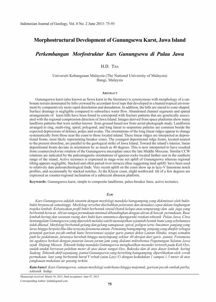
The Neogene limestone terrain bounded by the Opak River in the west and by the Grindulu river system in the east displays the typical Gunungsewu karst morphology that is dominated by numerous sinoid and conical hills. Administratively the area is called Gunungkidul of which a large part belongs to the Yogyakarta’s Special Region or “Daerah Is-timewa Yogyakarta” (Figure 1a). A relatively narrow eastern border zone of Gunungkidul is under Central and East Jawa administrations. The Javanese word “sewu” translates into “thousand”. Flathe & Pfeiffer (1965) used “sinoid” to describe the convex hill profiles. The karst hills resemble inverted coconut half- shells, that in the local language is referred to as “batok kelapa” or “tempurung”. Within longitu-dinal belts, the multitude of limestone hills possesses summits of nearly uniform elevation. The hill tops in the southern coastal zone are between 30 to 80 m high, while toward the hinterland summit elevations
gradually increase to 350 m and slightly over 400 m above sea level. Local topographic relief is around the 50-meter range. Early investigators already in-terpreted the gently southward decreasing hill tops as remnants of a raised, deposition-related surface or a reef-limestone platform (among others Grund 1914, Lehmann 1936, Escher 1951). Over time, the Sewu karst morphology became accepted as representing a typical advanced stage of carbonate-landform development under humid tropical conditions where denudation and especially dissolution transpire at rates more rapid than in other climates. In contrast, limestone karst landforms of non-tropical regions are dominated by planar surfaces that host spatially dispersed individual to composite depressions, such as sinkholes, dolines, poljes and uvalas. The non-tropical karst most probably represents an early stage of development. On the other hand, in the tropics, carbonate terrains appear to degrade morphologically more rapid resulting in the multitude of hill complexes such as the Chocolate Hills of Bohol, Philippines, the Pepino Hills in Puerto Rico, and the karst hills in the
110 O 00'
8 O 00'
50 km
7 O 30'
Merbabu
Wonogiri
I N D I A N O C E A N
L a w u
Merapi
K. O y o
K. Grindulu
Bengawan Solo
K. Kladen
Wonosari
Parangtritis
YOGYAKARTA
SURAKARTA
GUNUNG SEWU
Punung
Kali Progo
Baron
Watukarung
Sadeng
Nganut
111 O30'110 O 30' 111 O110 O 45'110 O 15'
1c19
15
5-6
16
11
Kali Opak
1b
Wediombo
8
13
17
79 - 12
18
6 - 10
Pacitan
Location of Figures
Figure 1a. Index map of Sewu karst in the Gunungkidul region. Numerals in squares indicate location of the figures of this communication.
Morphostructural Development of Gunungsewu Karst, Jawa Island (H.D. Tjia, et al.)
77
SLOPE PROFILES OF SINOIDS
TELUK BARON AREA(8 May 1968, field notes p.38)
29 10
85
4629
1915
14
14
38
4320
348
34
23
27
31
11
28
23
16
22
30
24
25
3418
24
14
11
3323
15
8
23
148
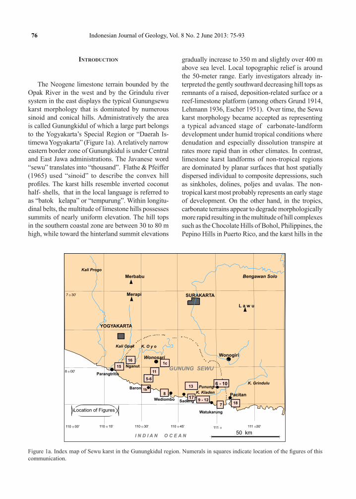
Figure 1b. The sinoid karst profiles that were measured along a track from Teluk Baron towards Wonosari. Numerals are in degrees.
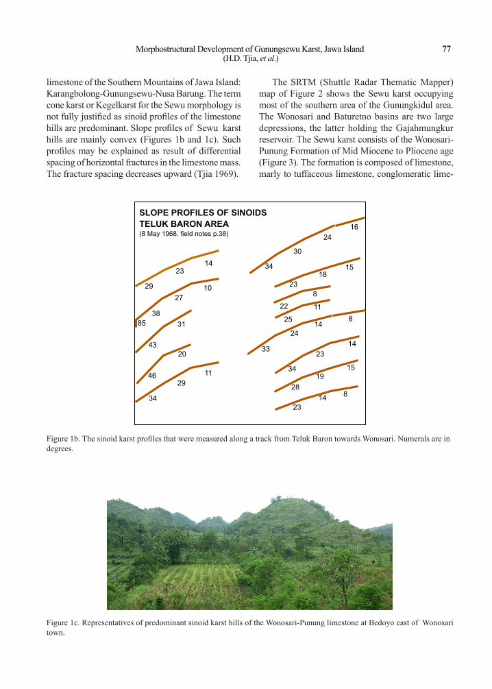
limestone of the Southern Mountains of Jawa Island: Karangbolong-Gunungsewu-Nusa Barung. The term cone karst or Kegelkarst for the Sewu morphology is not fully justified as sinoid profiles of the limestone hills are predominant. Slope profiles of Sewu karst hills are mainly convex (Figures 1b and 1c). Such profiles may be explained as result of differential spacing of horizontal fractures in the limestone mass. The fracture spacing decreases upward (Tjia 1969).
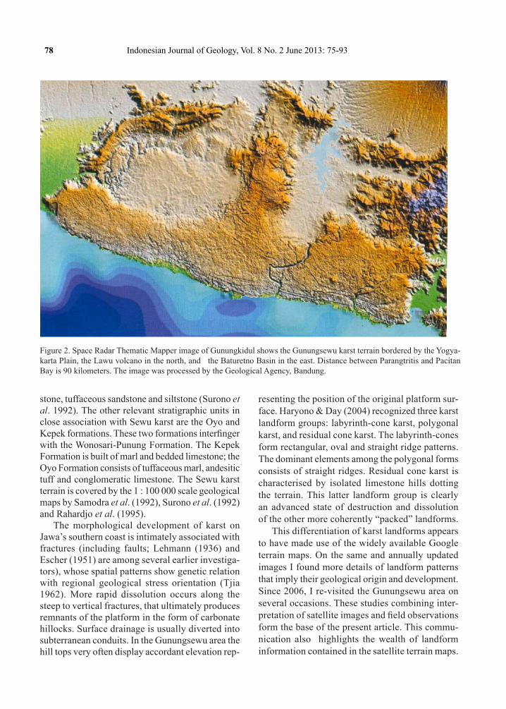
The SRTM (Shuttle Radar Thematic Mapper) map of Figure 2 shows the Sewu karst occupying most of the southern area of the Gunungkidul area. The Wonosari and Baturetno basins are two large depressions, the latter holding the Gajahmungkur reservoir. The Sewu karst consists of the Wonosari-Punung Formation of Mid Miocene to Pliocene age (Figure 3). The formation is composed of limestone, marly to tuffaceous limestone, conglomeratic lime-
Figure 1c. Representatives of predominant sinoid karst hills of the Wonosari-Punung limestone at Bedoyo east of Wonosari town.
78 Indonesian Journal of Geology, Vol. 8 No. 2 June 2013: 75-93
stone, tuffaceous sandstone and siltstone (Surono et al. 1992). The other relevant stratigraphic units in close association with Sewu karst are the Oyo and Kepek formations. These two formations interfinger with the Wonosari-Punung Formation. The Kepek Formation is built of marl and bedded limestone; the Oyo Formation consists of tuffaceous marl, andesitic tuff and conglomeratic limestone. The Sewu karst terrain is covered by the 1 : 100 000 scale geological maps by Samodra et al. (1992), Surono et al. (1992) and Rahardjo et al. (1995).
The morphological development of karst on Jawa’s southern coast is intimately associated with fractures (including faults; Lehmann (1936) and Escher (1951) are among several earlier investiga-tors), whose spatial patterns show genetic relation with regional geological stress orientation (Tjia 1962). More rapid dissolution occurs along the steep to vertical fractures, that ultimately produces remnants of the platform in the form of carbonate hillocks. Surface drainage is usually diverted into subterranean conduits. In the Gunungsewu area the hill tops very often display accordant elevation rep-
resenting the position of the original platform sur-face. Haryono & Day (2004) recognized three karst landform groups: labyrinth-cone karst, polygonal karst, and residual cone karst. The labyrinth-cones form rectangular, oval and straight ridge patterns. The dominant elements among the polygonal forms consists of straight ridges. Residual cone karst is characterised by isolated limestone hills dotting the terrain. This latter landform group is clearly an advanced state of destruction and dissolution of the other more coherently “packed” landforms.
This differentiation of karst landforms appears to have made use of the widely available Google terrain maps. On the same and annually updated images I found more details of landform patterns that imply their geological origin and development. Since 2006, I re-visited the Gunungsewu area on several occasions. These studies combining inter-pretation of satellite images and field observations form the base of the present article. This commu-nication also highlights the wealth of landform information contained in the satellite terrain maps.
Figure 2. Space Radar Thematic Mapper image of Gunungkidul shows the Gunungsewu karst terrain bordered by the Yogya-karta Plain, the Lawu volcano in the north, and the Baturetno Basin in the east. Distance between Parangtritis and Pacitan Bay is 90 kilometers. The image was processed by the Geological Agency, Bandung.
Morphostructural Development of Gunungsewu Karst, Jawa Island (H.D. Tjia, et al.)
79
LAndforms
Single Landforms and Landforms of Simple Patterns
Lineaments of Ridges and Valleys, Linear and Curv-ing Ridges
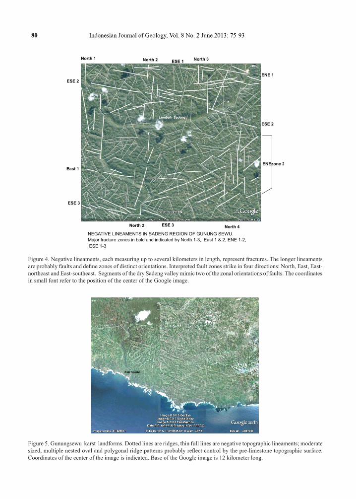
Linear features or lineaments are tonal or nega-tive/depressed as well as positive landforms on the satellite images. Segments are traceable over dis-tances of around one to 4-5 kilometers. Parallel oriented segments may form zones up to 2 kilome-ters wide. On Figure 4 are lineament zones striking North-South (4 zones), East-northeast (2 zones),
East-West (a single zone), and East-southeast (3 zones). The ESE zones are parallel to Pulau Jawa’s tectonic axis. These lineament zones are interpreted to represent major fracture belts of possibly tectonic origin. Segments of the dry Sadeng valley corre-spond with two of the lineament directions. Other smaller lineaments have various orientations and are shown by thin lines on the figure. These shorter linears very probably represent relatively minor fractures in the Gunungsewu karst.
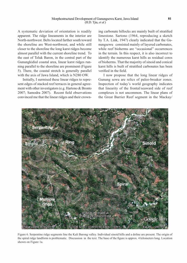
Over a sizable part of the Gunungsewu karst terrain kilometers’ long linear ridges occur in zones of well-defined orientation (Figure 5). The karst terrain is composed of long linear-ridge zones strike North-northwest from about Teluk Baron westward.
Qvm HoloceneQaQvl
QtQb
Tpdi
Tmpk
Tms
Tomm
Tmwl
Tmj
TmnTmw
Tmo
Tmss
Tomk
Tew
KTm
Tmng
Pleistocene
Oligocene
Pliocene
Late Miocene
Middle Miocene
Eocene
Early Miocene
C R E T A C E O U S
Paleocene
QUATER-
NARY
T
E
R
T
I
A
R
Y
STRATIGRAPHY OF GUNUNG SEWU AND ENVIRONS
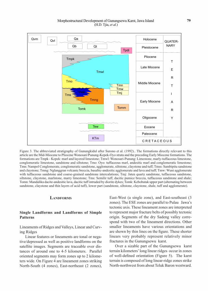
Figure 3. The abbreviated stratigraphy of Gunungkidul after Surono et al. (1992).. The formations directly relevant to this article are the Mid-Miocene to Pliocene Wonosari/Punung-Kepek-Oyo strata and the preceding Early Miocene formations. The formations are Tmpk - Kepek: marl and layered limestone; Tmwl: Wonosari-Punung: Limestone, marly-tuffaceous limestone, conglomeratic limestone, sandstone and siltstone; Tmo: Oyo: tuffaceous marl, andesitic marl and conglomeratic limestone; Tmn: Nampol Conglomerate, conglomeratic sandstone, agglomerate, siltstone, claystone and tuff; Tmss: Sambipitu sandstone and claystone; Tmng: Nglanggran volcanic breccia, basaltic-andesitic agglomerate and lava and tuff; Tmw: Wuni agglomerate with tuffaceous sandstone and coarse-grained sandstone intercalations; Tmj: Jaten quartz sandstone, tuffaceous sandstone, siltstone, claystone, marlstone, marry limestone; Tms: Semilir tuff, dacitic pumice breccia, tuffaceous sandstone and shale; Tomn: Mandalika dacite-andesitic lava, dacitic tuff intruded by diorite dykes; Tomk: Kebobutak upper part (alternating between sandstone, claystone and thin layers of acid tuff), lower part (sandstone, siltstone, claystone, shale, tuff and agglomerate).
80 Indonesian Journal of Geology, Vol. 8 No. 2 June 2013: 75-93
Kali Sambi
Figure 5. Gunungsewu karst landforms. Dotted lines are ridges, thin full lines are negative topographic lineaments; moderate sized, multiple nested oval and polygonal ridge patterns probably reflect control by the pre-limestone topographic surface. Coordinates of the center of the image is indicated. Base of the Google image is 12 kilometer long.
ESE 1
ESE 2
ESE 3
ESE 2
North 1
ENEzone 2
ENE 1
East 1
North 3North 2
ESE 3
North 2 North 4
Lembah Sadeng
NEGATIVE LINEAMENTS IN SADENG REGION OF GUNUNG SEWU.
Major fracture zones in bold and indicated by North 1-3, East 1 & 2, ENE 1-2,
ESE 1-3
Figure 4. Negative lineaments, each measuring up to several kilometers in length, represent fractures. The longer lineaments are probably faults and define zones of distinct orientations. Interpreted fault zones strike in four directions: North, East, East-northeast and East-southeast. Segments of the dry Sadeng valley mimic two of the zonal orientations of faults. The coordinates in small font refer to the position of the center of the Google image.
Morphostructural Development of Gunungsewu Karst, Jawa Island (H.D. Tjia, et al.)
81
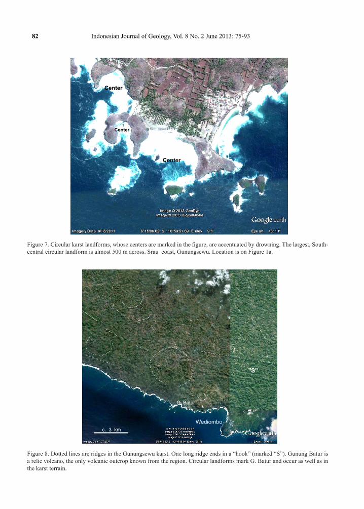
A systematic deviation of orientation is readily apparent. The ridge lineaments in the interior are North-northwest. Belts located farther south toward the shoreline are West-northwest, and while still closer to the shoreline the long karst ridges become almost parallel with the current shoreline trend. To the east of Teluk Baron, in the central part of the Gunungkidiul coastal area, linear karst ridges run-ning parallel to the shoreline are prominent (Figure 5). There, the coastal stretch is generally parallel with the axis of Jawa Island, which is N280 OW.
Initially, I surmised these linear ridges to repre-sent edges of stacked reef terraces in general agree-ment with other investigators (e.g. Hartono & Bronto 2007; Samodra 2007). Recent field observations convinced me that the linear ridges and their crown-
ing carbonate hillocks are mainly built of stratified limestone. Sartono (1964, reproducing a sketch by T.A. Link, 1947) clearly indicated that the Gu-nungsewu consisted mainly of layered carbonates, while reef bioherms are “occasional” occurrences in the terrain. In this respect, it is also incorrect to identify the numerous karst hills as residual cores of bioherms. That the majority of sinoid and conical karst hills is built of stratified carbonates has been verified in the field.
I now propose that the long linear ridges of Gunung sewu are relics of paleo-breaker zones. Inspection of today’s world geography indicates that linearity of the frontal/seaward side of reef complexes is not uncommon. The linear plans of the Great Barrier Reef segment in the Mackay/
Ring
Spiral
Multiple rings
Sinoid
Serpentine
8 O 10'56.52" S 111 O 00' 00.56' E Elevation 10001 feet
Sinoid
Figure 6. Serpentine ridge segments line the Kali Barong valley. Individual sinoid hills and a doline are present. The origin of the spiral ridge landform is problematic. Discussion in the text. The base of the figure is approx. 4 kilometers long. Location shown on Figure 1a.
82 Indonesian Journal of Geology, Vol. 8 No. 2 June 2013: 75-93
Center
Center
Center
Figure 7. Circular karst landforms, whose centers are marked in the figure, are accentuated by drowning. The largest, South-central circular landform is almost 500 m across. Srau coast, Gunungsewu. Location is on Figure 1a.
Wediombo
c. 3 km
G. Batur
"S"
Figure 8. Dotted lines are ridges in the Gunungsewu karst. One long ridge ends in a “hook” (marked “S”). Gunung Batur is a relic volcano, the only volcanic outcrop known from the region. Circular landforms mark G. Batur and occur as well as in the karst terrain.
Morphostructural Development of Gunungsewu Karst, Jawa Island (H.D. Tjia, et al.)
83
Lembah Sadeng - details
Pseud
o-slide
marks
Pseudo-slide
marks
Giritontro
Lembah Sadeng
c. 5 km
3
1
2
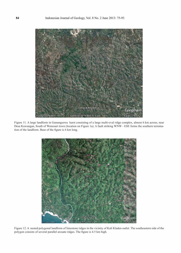
Figure 10. Long limestone ridges in two orientations and ‘pseudo-slide marks” in the area of the dry Sadeng Valley of Gu-nungkidul. The “pseudo-slide marks” consist of a circular ridge attached to two long parallel ridges. The paired ridges “trail” in NW and in SE direction, respectively.
Dringo
Agricultural plots mimic
topographic contours
circa 2 km
Buyutan
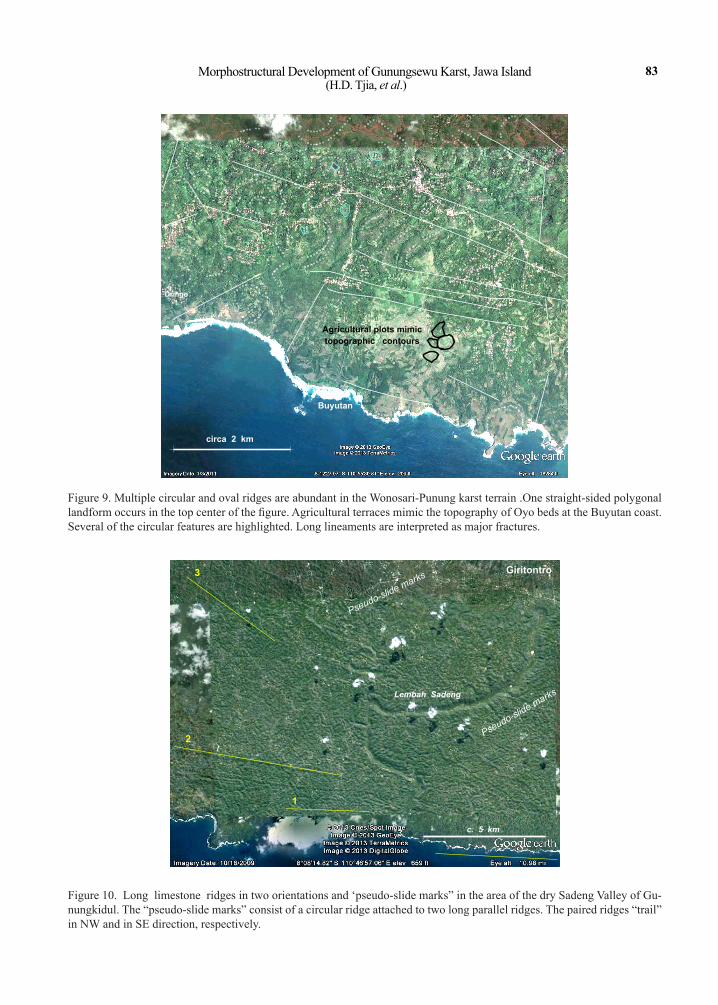
Figure 9. Multiple circular and oval ridges are abundant in the Wonosari-Punung karst terrain .One straight-sided polygonal landform occurs in the top center of the figure. Agricultural terraces mimic the topography of Oyo beds at the Buyutan coast. Several of the circular features are highlighted. Long lineaments are interpreted as major fractures.
84 Indonesian Journal of Geology, Vol. 8 No. 2 June 2013: 75-93
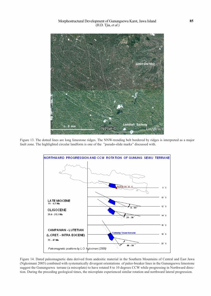
Figure 11. A large landform in Gunungsewu karst consisting of a large multi-oval ridge complex, almost 6 km across, near Desa Kuwangan, South of Wonosari town (location on Figure 1a). A fault striking WNW - ESE forms the southern termina-tion of the landform. Base of the figure is 6 km long.
Figure 12. A nested polygonal landform of limestone ridges in the vicinity of Kali Kladen outlet. The southeastern side of the polygon consists of several parallel arcuate ridges. The figure is 4.5 km high.
Morphostructural Development of Gunungsewu Karst, Jawa Island (H.D. Tjia, et al.)
85
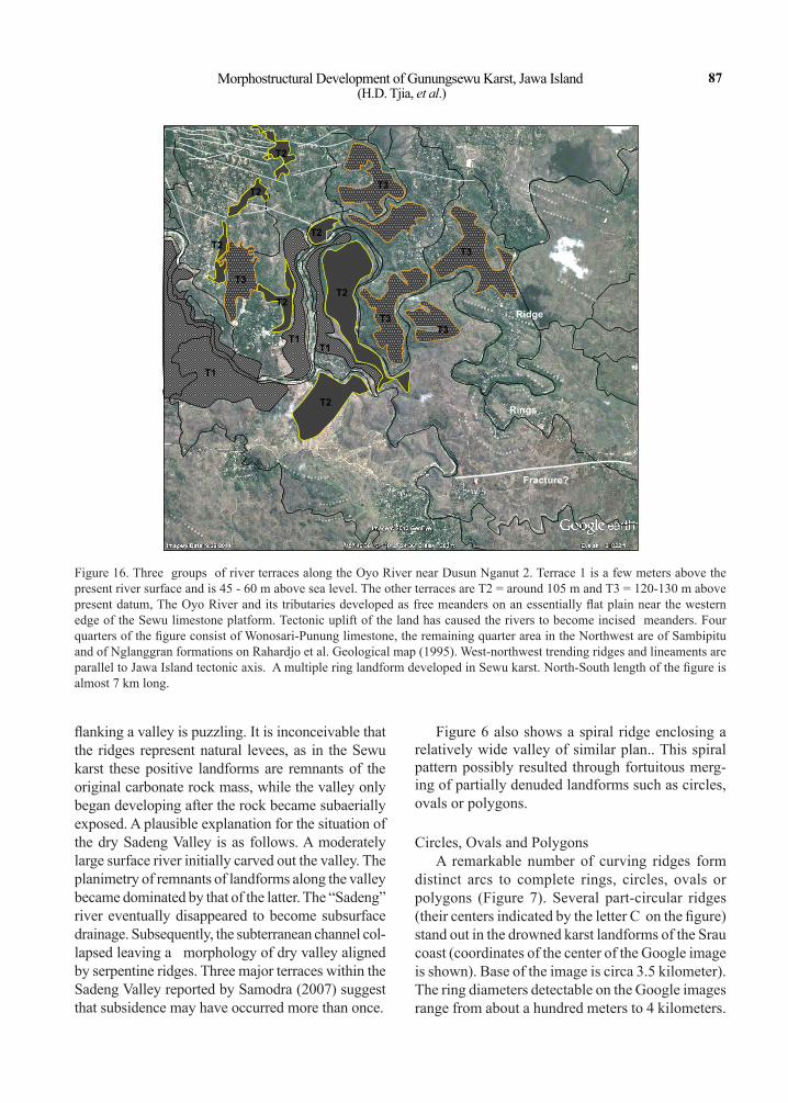
Figure 14. Dated paleomagnetic data derived from andesitic material in the Southern Mountains of Central and East Jawa (Ngkoimani 2005) combined with systematically divergent orientations of paleo-breaker lines in the Gunungsewu limestone suggest the Gunungsewu terrane (a mircoplate) to have rotated 8 to 10 degrees CCW while progressing in Northward direc-tion. During the preceding geological times, the microplate experienced similar rotation and northward lateral progression.
Lembah Sadengc. 6 km
GIRITONTRO
Figure 13. The dotted lines are long limestone ridges. The NNW-trending belt bordered by ridges is interpreted as a major fault zone. The highlighted circular landform is one of the ”pseudo-slide marks” discussed with.

86 Indonesian Journal of Geology, Vol. 8 No. 2 June 2013: 75-93
Capricorn Management Area extend over 50 km and also over 130 kilometers are documented on Map No. SDC041206, September 2004. The map can be accessed through the Internet. The landward side of the Queensland Trough, also of the Great Barrier Reef, is lined by stacked carbonate fronts (see American Geophysical Union, EOS v. 89, No. 24, 2008). Laboratory water-tank experiments by P.D. Timmermans distinctly show the position of offshore bars to correspond with breaker zones (shown on p. 221, Escher 1951). On an extensive gently shelving shallow sea floor, breakers can be expected to develop long linear offshore bars. The systematic changes in orientation of such long linear ridges at Gunungsewu are interpreted to correspond
with counterclockwise rotation while experiencing spasmodic uplift of the Sewu karst terrain through time. This idea will be elaborated upon in a later part of the article.
Serpentine and Spiral RidgeSimple curving ridges generally occur in parallel
pairs. A curving ridge-pair sandwiches stream val-leys, which are usually dry or host underfit rivers (Figure 6). The pairs of serpentine ridges extend over distances that may exceed 10 kilometers. Such pairs occur along stretches of the Sadeng Valley and Kali Sambi and along its middle course named Kali Barong. The parallel association of serpentine ridges
INDIAN OCEAN
Intertidal zone Polygonal landform
Sand ridges
Linear ridges
Major fault
Left lateral wrench zone
Parangtritis
Down U p
PEDIPLAIN OF YOGYAKARTA-MERAPI
PEDIPLAIN OF YOGYAKARTA-MERAPI
G. SEWUG. SEWU
285 m
225 m175m
135 m
190 m
140 m 170 m
IBreaker line
Figure 15. A northerly oriented zone of en echelon smaller scarps accompany the major fault-line scarp that forms the west-ern boundary of Gunungkidul. The smaller scarps are step faults down-throwing to the west with a left-lateral component of displacement. This fault zone, named Parangtritis Fault Zone, is probably a splay of the Opak Fault Zone that strikes north-easterly and separates Gunungsewu from the Yogyakarta lowland.
Morphostructural Development of Gunungsewu Karst, Jawa Island (H.D. Tjia, et al.)
87
flanking a valley is puzzling. It is inconceivable that the ridges represent natural levees, as in the Sewu karst these positive landforms are remnants of the original carbonate rock mass, while the valley only began developing after the rock became subaerially exposed. A plausible explanation for the situation of the dry Sadeng Valley is as follows. A moderately large surface river initially carved out the valley. The planimetry of remnants of landforms along the valley became dominated by that of the latter. The “Sadeng” river eventually disappeared to become subsurface drainage. Subsequently, the subterranean channel col-lapsed leaving a morphology of dry valley aligned by serpentine ridges. Three major terraces within the Sadeng Valley reported by Samodra (2007) suggest that subsidence may have occurred more than once.
Figure 6 also shows a spiral ridge enclosing a relatively wide valley of similar plan.. This spiral pattern possibly resulted through fortuitous merg-ing of partially denuded landforms such as circles, ovals or polygons.
Circles, Ovals and PolygonsA remarkable number of curving ridges form
distinct arcs to complete rings, circles, ovals or polygons (Figure 7). Several part-circular ridges (their centers indicated by the letter C on the figure) stand out in the drowned karst landforms of the Srau coast (coordinates of the center of the Google image is shown). Base of the image is circa 3.5 kilometer). The ring diameters detectable on the Google images range from about a hundred meters to 4 kilometers.
T2
T1
T1T1
T2
T2
T2
T3
T2
T2
T2
T3
T3
Ridge
Rings
Fracture?
T3
T3
Figure 16. Three groups of river terraces along the Oyo River near Dusun Nganut 2. Terrace 1 is a few meters above the present river surface and is 45 - 60 m above sea level. The other terraces are T2 = around 105 m and T3 = 120-130 m above present datum, The Oyo River and its tributaries developed as free meanders on an essentially flat plain near the western edge of the Sewu limestone platform. Tectonic uplift of the land has caused the rivers to become incised meanders. Four quarters of the figure consist of Wonosari-Punung limestone, the remaining quarter area in the Northwest are of Sambipitu and of Nglanggran formations on Rahardjo et al. Geological map (1995). West-northwest trending ridges and lineaments are parallel to Jawa Island tectonic axis. A multiple ring landform developed in Sewu karst. North-South length of the figure is almost 7 km long.
88 Indonesian Journal of Geology, Vol. 8 No. 2 June 2013: 75-93
Examples are also on Figures 5 and 8. Single circular ridges are among the smaller category. The positive circular topography includes the insular karst hills. Gunung Batur, a volcanic remnant at the coast of Wediombo is marked by a circular feature (Figure 8). Hartono & Bronto (2007) already noticed this feature. In the Gunungsewu karst terrain, other fea-tures associated with the smaller sized circular ridges are dolines/sinkholes and denudational depressions (Figure 6). The latter category is clearly seen in the drowned karst topography at the Srau coast. Many circular and ring-like drowned karst islets occur in the Raja Ampat Regency (encompassing the islands Sala-wati, Batanta, Kofiau and Misool in the West Papua region), and the Tukangbesi Islands southeastern Sulawesi. Drowned karst landforms of similar plans are also known from the Palau islands in the western Pacific. The abundance of circular landforms in the Sewu terrain is remarkable. To my knowledge, none of the other investigators had attempted an explanation of their existence. Among the most plausible explanation is that the circular landforms in Gunungkidul were atolls that developed atop sinking seamounts and other drowned hill/mountain relief. In Gunungkidul, the Wonosari-Punung-Oyo strata are separated by angular unconformity from older formations (Figure 3). In other words, this unconformity could well represent land surface composed of hills of rounded plans that served as foundations for the growing reefs.
The relatively small positive landforms associated with circular outline consist of individual sinoid and cone-shaped karst hills, representing residual parts of the raise carbonate platform (Figure 6).
Straight to irregular sided polygons are also rela-tively small and some may be water-filled (Figure 9). Irregular sided polygons mark small depressions of up to a hundred or so meters across. This depressed landform type has probably developed by a combina-tion of denudation creating the hollow and subsequent infilling of sediments that onlapped onto the base of the surrounding hills.
Pseudo-slide PatternsA remarkable combination of linear ridges and
circular landform is displayed near a bend of the dry Sadeng valley and also occur in less distinct form at a few other locations in Sewu karst. For convenience of reference, this morphological ridge and circular feature composite is named “pseudo-slide marks”.
The circular feature appearing as a morphological unit with the two ridges resembling trailing tracks. The circular ridge (located at East of center in Figure 10) is prominent and is at the Southeast end of two parallel ridges. As explained earlier, the ridges are interpreted as depositional fronts marking paleo-breaker zones, while the circular landforms were probably once atolls. In this particular instance, it is envisaged that an atoll (the circular landform) combined with a long strip of shallow submerged ridge that was flanked by breaker zones. At the NW end of the parallel ridges are three other, recognizable ring-like ridges. Diam-eters measure about a kilometer). A closer look is on Figure 13. To the SE of the Sadeng valley occurs an other “pseudo-slide mark” association. The linear parts of the marks trend West-northwest. Center of the Google image is at 8 O 06’ 14.05” S, 110 O 45’ 51.50”E, elevation is 1179 feet or 354 m.
Composite Landforms
The singular, simple landforms of Sewu karst may combine into definitive patterns. Such composite landforms fall into two categories.
Concentric Multiple Ring or Oval PatternsOn the satellite images multi-ring patterns have
diameters of several kilometers (Figures 5 and 9). Double rings are most common among this landform category. More than two concentric rings of ridges are shown on Figures 5 and 9. Figure 11 shows a very large landform pattern consisting of numerous concentric oval ridges near Kuwangan village to the South of Wonosari. More than ten concentric oval ridges can be counted. Part of the more than 6-kilo-meter wide oval landform is cut by a WNW - ESE fault (straight lineament).
The pattern of multiple concentric ridges strongly suggests outward growth of calcareous depositional fronts around a central edifice.Nested Polygons
Straight-edged polygonal ridge patterns are rare as Sewu karst landform. An example of nested polygons is on Figure 12.
Plans of such types of polygons presumably mark control by fractures during topographic degradation.
morpho-structurAL deveLopment
Orientation and Distribution of Long Linear Ridges
Morphostructural Development of Gunungsewu Karst, Jawa Island (H.D. Tjia, et al.)
89
It was pointed out in Figure 4 that linear ridges may bunch together and form belts of definitive orientation. These belts of linear ridges most probably define tec-tonic fault zones. Long, slightly curving ridges to the west of Giritontro trend Northwest (Figure 13). Two of such ridges belong to the “pseudo-slide” feature discussed earlier and that have been classified as paleo-breaker zones. A 1.5 kilometer wide belt consisting of landforms of diffused pattern that is contained between two lineaments striking a few degrees West of North transect some of the Northwest ridges. This belt is interpreted as part of a regional fault zone, which is also detectable on the smaller scale SRTM image.
From the current shoreline into the hinterland, systematic changes in orientation of long linear ridges are clearly observable in many parts of Gunungsewu (Figures 6, 8, 9, 10). Arguments for their “breaker-zone” origin were presented earlier in this article. Three changes of long-ridge orientation are shown on Figure 10. Closest to the Indian Ocean, the pres-ent shoreline and ridge lineament 1 are parallel, both trending 95 degrees. Farther inland, ridge lineament 2 strikes 100 degrees. Farthest inland on Figure 10, ridge lineament 3 strikes 125 degrees.
This systematic change in ridge-lineament orien-tation is interpreted to correspond with counterclock-wise rotation of the Southern Mountains belt during progradational deposition of the Wonosari-Punung Formation in late Middle Miocene into Early Pliocene. Ngkoimani (2005) measured paleomagnetic orienta-tions of andesites of Central and East Jawa and found among other information that since the period between 11 Ma and 6.7 Ma (Middle to Late Miocene), those terrains of the island had rotated counterclockwise by 8 to 10 degrees while progressing in northerly direction. The change in orientation of interpreted breaker-lines of Gunungsewu have been integrated with dated paleomagnetic CCW-rotation (Figure 14). Ngkoimani et al. (2006) also provided data of the paleomagnetic positions of the Southern Mountains (including Gunungsewu) of Jawa Island from the Campanian - Lutetian (75 to 47 Ma). According to the data, the Gunungsewu terrane was located about 11 degrees farther to the South with an orientation trend-ing Northwest, or 40 to 50 degrees off the current one which is West-northwest. Since then, the terrane had moved northward while rotating CCW.
pArAngtrItIs fAuLt Zone
The 400-500 m high scarp forming the west-ern edge of Gunungsewu exposes Oligo-Miocene volcaniclastic and volcanic rocks of the Semilir-Nglanggran-Sambipitu formations below the Wonosari-Punung limestone (see Rahardjo et al. 1995). It is the fault-line scarp of the Opak Fault zone oriented Northeast. A probable splay of the fault at the Parangtritis end trends only a few degrees East from the meridian (Figure 15). For reference purpose, this probable splay is named Parangtritis Fault zone (PFZ). The Google image shows en echelon arrays of smaller scarps oriented northwesterly within the PFZ. Individual scarps are associated with topographic drops that increase from 30 m in the vicinity of Parangtritis to 95 m near Desa Cangkring, about 10 kilometers to its North. The en echelon arrangement of fault scarps of PFZ indicate left-lateral wrenching in addition to downthrows westward. A series of major faults show up on the figure as lineaments striking parallel to Jawa’s island axis.
ActIve tectonIcs
Stream TerracesThe well-documented stream terraces of Kali
Baksoka and those along the Bengawan Solo have been essential in estimating ages of paleo-anthro-pological findings in the area, among many others by Sartono (1964). The stacked terraces have been considered indicators for geologically recent verti-cal ground movements. Figure 16 shows the river morphology along the middle course of the Oyo River within Gunungsewu. Three quarters of the figure consist of the Wonosari limestone; clastics of the Sambipitu Formation are in the northwest and in the top-central part of the figure. Vertical crustal movement is immediately apparent from the incised character of meanders. The well-developed meander pattern, including those of the tributaries, points to origin on a level land surface. Three sets of river terraces exist. T1, T2 and T3 comprise of terrace surfaces 45-60 m, about 105 m, and 120-130 m above present datum.
Along the dry Sadeng Valley, Samodra (2007) grouped three sets of terraces at 20 - 80 m, 60 - 100
90 Indonesian Journal of Geology, Vol. 8 No. 2 June 2013: 75-93
m, and 100 - 140 m. The lower group of terraces may be covered by alluvium whose thickness can exceed 10 meters. The other group of the Sadeng terraces are mantled by terra rossa.
Coastal TerracesOn the limited number of Gunungsewu coasts I
was able to visit, I observed that coastal equivalents of the lower set of the Sadeng Valley terrace-levels can be further subdivided. There appears to be coastal terraces at around 2 m, 6 m, 15-20 m, around 40 m, and finally at about 80 m. The still higher-level Sadeng terrace equivalents have yet to be determined on the Gunungsewu coast.
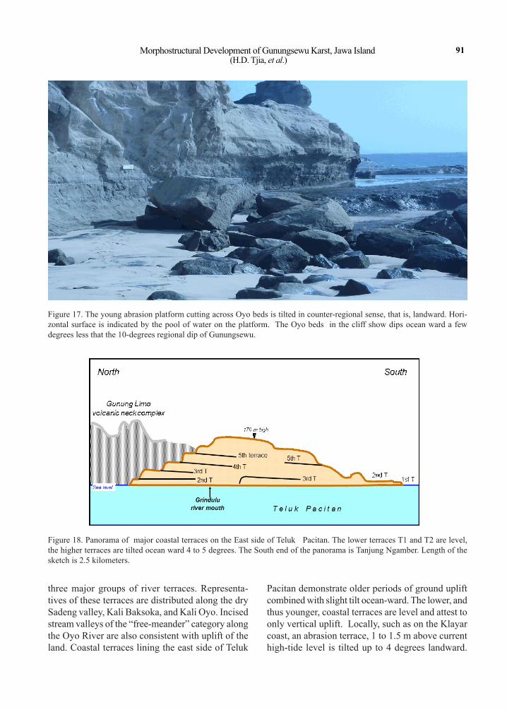
At Pantai Klayar, the vegetation-free abrasion platform of 1.5 to 2 m above current high tide is tilted landward at less than 5 degrees. While the stratified Wonosari beds across which the abrasion platform was cut, dips seaward at 6 to 8 degrees (Figure 17). The landward tilt of the platform implies a very recent counter-regional tilt of at least 4 degrees had taken place.
On the east side of Pacitan Bay are five major terraces (Figure 18). The top level of the hilly area summits at 170 meter according to a topographic map and may be a relic of a sixth terrace. Terrace 1, the bottom representative, is a recently uplifted abrasion surface barren of vegetation. This terrace and the second higher terrace are of level surfaces. The third and higher terraces are tilted 4 to 5 degrees towards South. The coastal panorama indicates that the third and higher terraces resulted from spasmodic vertical uplift and then experienced Southward tilt-ing prior to the development of the younger second and first terraces which were subjected to only verti-cal ground movements.
Sea-level NotchesFrom more than half of a century of coastal stud-
ies I have become convinced that sea-level notch- profiles are direct indicators of tectonic condition. First, the deepest part of a notch corresponds with mean sea level. Second, the notch opening/height is indicative of prevailing wave height and tidal range as Verstappen (1960) has stressed. Third, the two basic notch profiles are the “Lazy V” (resembling re-cumbent letter V) and “Fish-hook” (Figure 19), that correlate with actively rising coast and tectonically stable coast, respectively. On my part, this realisa-
tion has been rather recent. Comparison of notches on many coasts of the core of tectonically stable Sundaland (Bangka, Belitung, Peninsular Malay-sia) with those on coasts of known tectonic activity (eastern Sulawesi, Tukangbesi Islands, Banda Sea islands, Nusatenggara, Sabah-East Malaysia, and Gunungsewu) has borne this out.
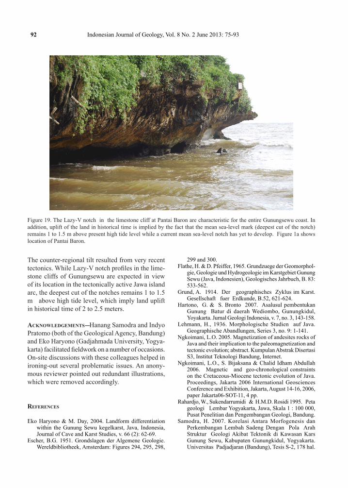
The limestone coastal cliffs of central and east-ern Gunungsewu have Lazy-V notches (Figure 19). However, the deepest cut of the notches remains a meter to 1.5 meter above current high tide. At Teluk Baron and Sadeng, level abrasion benches at the foot of notches are also above the current wave base. The present mean sea level notch has yet to develop. The elevated position of the deepest cut of notches and absence of a notch corresponding to current tidal conditions imply that vertical uplift, estimated at more than 2 meters had occurred recently, even in terms of our historical time frame.
summAry And concLusIons
In addition to the usual karst morphology of sinoid hills, dry valleys, subsurface drainage chan-nels, caves and sinkholes, the Gunungsewu karst also form simple patterns of long linear ridges, paired serpentine ridges, circles, ovals, straight-edged polygons, that may combine into multiple rings and nested polygons. Circular and multi-ring landforms are common, but not all can be related to atolls. It is a fact that reefs represent only a small por-tion of the Gunungsewu karst, that predominantly consists of stratified calcareous sedimentary rock. Pre-carbonate topography of hill tops was presum-ably influential in shaping depositional patterns of the carbonates, reefs and calcareous clastics alike. Kilometers’ long linear ridges are interpreted as elevated paleo-breaker zones. Linear ridges closest to the ocean and the present shoreline run essentially parallel. Toward the hinterland their orientations in-creasingly diverge from the shoreline to attain angles of up to 40 degrees. The diverging orientations pos-sibly correspond to progressive CCW rotation of the Gunungsewu terrane when it shifted Northward from an Mid-Miocene position at 10 to 11 O S as suggested by paleomagnetic data.
Vertical ground movement of the Gunungsewu terrane has occurred periodically and has produced
Morphostructural Development of Gunungsewu Karst, Jawa Island (H.D. Tjia, et al.)
91
Figure 18. Panorama of major coastal terraces on the East side of Teluk Pacitan. The lower terraces T1 and T2 are level, the higher terraces are tilted ocean ward 4 to 5 degrees. The South end of the panorama is Tanjung Ngamber. Length of the sketch is 2.5 kilometers.
Figure 17. The young abrasion platform cutting across Oyo beds is tilted in counter-regional sense, that is, landward. Hori-zontal surface is indicated by the pool of water on the platform. The Oyo beds in the cliff show dips ocean ward a few degrees less that the 10-degrees regional dip of Gunungsewu.
three major groups of river terraces. Representa-tives of these terraces are distributed along the dry Sadeng valley, Kali Baksoka, and Kali Oyo. Incised stream valleys of the “free-meander” category along the Oyo River are also consistent with uplift of the land. Coastal terraces lining the east side of Teluk
Pacitan demonstrate older periods of ground uplift combined with slight tilt ocean-ward. The lower, and thus younger, coastal terraces are level and attest to only vertical uplift. Locally, such as on the Klayar coast, an abrasion terrace, 1 to 1.5 m above current high-tide level is tilted up to 4 degrees landward.
92 Indonesian Journal of Geology, Vol. 8 No. 2 June 2013: 75-93
The counter-regional tilt resulted from very recent tectonics. While Lazy-V notch profiles in the lime-stone cliffs of Gunungsewu are expected in view of its location in the tectonically active Jawa island arc, the deepest cut of the notches remains 1 to 1.5 m above high tide level, which imply land uplift in historical time of 2 to 2.5 meters.
AcknowLedgements---Hanang Samodra and Indyo Pratomo (both of the Geological Agency, Bandung) and Eko Haryono (Gadjahmada University, Yogya-karta) facilitated fieldwork on a number of occasions. On-site discussions with these colleagues helped in ironing-out several problematic issues. An anony-mous reviewer pointed out redundant illustrations, which were removed accordingly.
references
Eko Haryono & M. Day, 2004. Landform differentiation within the Gunung Sewu kegelkarst, Java, Indonesia, Journal of Cave and Karst Studies, v. 66 (2): 62-69.
Escher, B.G. 1951. Grondslagen der Algemene Geologie. Wereldbibliotheek, Amsterdam: Figures 294, 295, 298,
299 and 300.Flathe, H. & D. Pfeiffer, 1965. Grundzuege der Geomorphol-
gie, Geologie und Hydrogeologie im Karstgebiet Gunung Sewu (Java, Indonesien), Geologisches Jahrbuch, B. 83: 533-562.
Grund, A. 1914. Der geographisches Zyklus im Karst. Gesellschaft fuer Erdkunde, B.52, 621-624.
Hartono, G. & S. Bronto 2007. Asalusul pembentukan Gunung Batur di daerah Wediombo, Gunungkidul, Yoyakarta. Jurnal Geologi Indonesia, v. 7, no. 3, 143-158.
Lehmann, H., 1936. Morphologische Studien auf Java. Geographische Abandlungen, Series 3, no. 9: 1-141.
Ngkoimani, L.O. 2005. Magnetization of andesites rocks of Java and their implication to the paleomagnetization and tectonic evolution; abstract. Kumpulan Abstrak Disertasi S3, Institut Teknologi Bandung, Internet.
Ngkoimani, L.O., S. Bijaksana & Chalid Idham Abdullah 2006. Magnetic and geo-chronological constraints on the Cretaceous-Miocene tectonic evolution of Java. Proceedings, Jakarta 2006 International Geosciences Conference and Exhibition, Jakarta, August 14-16, 2006, paper Jakarta06-SOT-11, 4 pp.
Rahardjo, W., Sukendarrumidi & H.M.D. Rosidi 1995. Peta geologi Lembar Yogyakarta, Jawa, Skala 1 : 100 000, Pusat Penelitian dan Pengembangan Geologi, Bandung.
Samodra, H. 2007. Korelasi Antara Morfogenesis dan Perkembangan Lembah Sadeng Dengan Pola Arah Struktur Geologi Akibat Tektonik di Kawasan Kars Gunung Sewu, Kabupaten Gunungkidul, Yogyakarta. Universitas Padjadjaran (Bandung), Tesis S-2, 178 hal.
Figure 19. The Lazy-V notch in the limestone cliff at Pantai Baron are characteristic for the entire Gunungsewu coast. In addition, uplift of the land in historical time is implied by the fact that the mean sea-level mark (deepest cut of the notch) remains 1 to 1.5 m above present high tide level while a current mean sea-level notch has yet to develop. Figure 1a shows location of Pantai Baron.
Morphostructural Development of Gunungsewu Karst, Jawa Island (H.D. Tjia, et al.)
93
Samodra, H., S. Gafoer & S. Tjokrosapoetro 1992. Peta geologi Lembar Pacitan, Jawa, skala 1 : 100 000. Pus-litbang Geologi, Bandung.
Sartono, S. 1964. Stratigraphy and sedimentation of the easternmost part of Gunung Sewu (East Java). Publikasi Teknik Seri Geologi Umum 1, Direktorat Geologi, Bandung.
Surono, B. Toha & I. Sudarno 1992. Peta Geologi Lembar Surakarta-Giritontro, Jawa. Skala 1 : 100 000. Pusat Penelitian dan Pengembangan Geologi, Bandung.
Tjia, H.D. 1962. Topographic lineaments in Nusa Barung, East Java. Institut Teknologi Bandung Proceedings v. 2 (2), 89-98.
Tjia, H.D. 1969. Slope development in tropical karst. Zeitschrift fuer Geomorphologie 13 (3), 260-266.
Tjia, H.D. & H. Samodra 2011. Active crustal deformation at the coast of Gunung Sewu, Jawa. Proceedings Asian Trans-Disciplinary Karst Conference 2011, Yogyakarta, January 2011:17-21.
Tjia, H.D. & S.A. Sharifah Mastura 2013. Sea-level Changes in Peninsular Malaysia: A Geological Record. Universiti Kebangsaan Malaysia Publisher, Bangi, Malaysia, 150pp.
Verstappen, H. Th. 1960. On the geomorphology of raised coral reefs and its tectonic significance. Zeitschrift fuer Geomorphologie, B. 4 (1), 1-28.