![[Document title] - Marine Scotland Informationmarine.gov.scot/sites/default/files/moray_east...[Document title] [DOCUMENT SUBTITLE] LAURA PARIS Emergency Response Cooperation Plan](https://static.fdocuments.us/doc/165x107/5f102f6c7e708231d447ddab/document-title-marine-scotland-document-title-document-subtitle-laura.jpg)
moray offshore renewables ltd - Marine Scotland...
38
Telford, Stevenson, MacColl Wind Farms and associated Transmission Infrastructure Environmental Statement Environmental Statement Technical Appendix 5.4 A - SLVIA Methodology moray offshore renewables ltd
Transcript of moray offshore renewables ltd - Marine Scotland...
Telford, Stevenson, MacColl Wind Farms and associated Transmission InfrastructureEnvironmental Statement
Environmental Statement
Technical Appendix 5.4 A - SLVIA Methodology
moray offshore renewables ltd
EDPR APP Covers 07/07/2012 17:13 Page 105

Moray Offshore Renewables Limited - Environmental Statement
Telford, Stevenson and MacColl Offshore Wind Farms and Transmission Infrastructure
This page has been intentionally left blank.
EDPR APP Covers 07/07/2012 17:13 Page 106

Moray Offshore Renewables Limited - Environmental Statement
Telford, Stevenson and MacColl Offshore Wind Farms and Transmission Infrastructure
moray offshore renewables limited
4th Floor 40 Princes Street Edinburgh EH2 2BY Tel: +44 (0)131 556 7602
This document was produced by Optimised Environments Ltd on behalf of Moray Offshore Renewables Ltd
Document Owner
Document Status Final
File Name
Revision Date Description Originated By
Checked By
Approved By
A1 06/06/12 For review OPEN SW PM

Moray Offshore Renewables Limited - Environmental Statement
Telford, Stevenson and MacColl Offshore Wind Farms and Transmission Infrastructure
This page has been intentionally left blank.
Moray Offshore Renewables Limited - Environmental Statement
Telford, Stevenson and MacColl Offshore Wind Farms and Transmission Infrastructure
Technical Appendix 5.4 A – SLVIA 1
Contents 1. SLVIA Baseline Study ......................................................................................................... 3
1.1 Introduction ............................................................................................................................ 3
1.2 Coastal and ‘Seascape’ / Landscape Characterisation Methodology ..................................... 4
1.2.1 Preliminary Stage: Prepare a Brief ................................................................................. 5
1.2.1.1 Development Scenario ............................................................................................................................ 5 1.2.1.2 Search Area .............................................................................................................................................. 6 1.2.1.3 Study Area – Offshore Generating Stations and OSPs ............................................................................. 6 1.2.1.4 Study Area – Offshore Transmission Infrastructure (onshore elements) ................................................ 7 1.2.1.5 Appropriate Map Scale ............................................................................................................................ 7
1.2.2 Stage One: Identify National Seascape Character Types ................................................ 7
1.2.3 Stage Two: Identify Terrestrial Landscape Character Types .......................................... 8
1.2.4 Stage Three: Identify Coastal Character Areas ............................................................... 9
1.2.5 Stage Four: Undertake Sensitivity Analysis .................................................................. 11
1.2.6 Stage Five: Undertake Impact Assessment .................................................................. 12
1.3 Visual Baseline ...................................................................................................................... 12
2. SLVIA Impact Assessment Methodology ..................................................................... 14
2.1 Landscape Effects: Physical .................................................................................................. 15
2.1.1 Sensitivity Criteria ......................................................................................................... 15
2.1.2 Magnitude Criteria ....................................................................................................... 15
2.1.3 Significance ................................................................................................................... 16
2.2 Effects on Seascape and Landscape Character .................................................................... 16
2.2.1 Sensitivity Criteria ......................................................................................................... 16
2.2.2 Magnitude Criteria ....................................................................................................... 17
2.2.3 Significance ................................................................................................................... 18
2.3 Visual Effects......................................................................................................................... 18
2.3.1 Sensitivity Criteria ......................................................................................................... 19
2.3.2 Magnitude Criteria ....................................................................................................... 19
2.3.3 Significance ................................................................................................................... 20
2.4 Assessing the Significance of Seascape, Landscape and Visual Effects ................................ 20
2.5 Nature of Effects ................................................................................................................... 21
2.6 Duration and Reversibility .................................................................................................... 23
Moray Offshore Renewables Limited - Environmental Statement
Telford, Stevenson and MacColl Offshore Wind Farms and Transmission Infrastructure
2 Technical Appendix 5.4 A – SLVIA
3. Methodology for the Assessment of Cumulative Effects .......................................... 23
3.1 Cumulative Effect Scenarios ................................................................................................. 24
3.2 Types of Cumulative Effect ................................................................................................... 25
3.3 Wind farms Included in Cumulative Assessment ................................................................. 26
3.4 Cumulative Magnitude of Change ........................................................................................ 26
3.5 Significance of Cumulative Effects ........................................................................................ 27
3.6 Graphic Techniques .............................................................................................................. 28
3.6.1 Zone of Theoretical Visibility (ZTV) ............................................................................... 28
3.6.2 Visualisations ................................................................................................................ 29
3.6.2.1 Software Packages Used ........................................................................................................................ 30 3.6.2.2 Camera Information .............................................................................................................................. 30 3.6.2.3 Terrain Data Used .................................................................................................................................. 30 3.6.2.4 Turbine Model Information ................................................................................................................... 30
3.6.3 Modelling Methodology ............................................................................................... 30
3.7 References ............................................................................................................................ 33
Moray Offshore Renewables Limited - Environmental Statement
Telford, Stevenson and MacColl Offshore Wind Farms and Transmission Infrastructure
Technical Appendix 5.4 A – SLVIA 3
The Seascape, Landscape and Visual Assessment (SLVIA) methodology sets out the methodology for the seascape, landscape and visual baseline study in ES Section 5.4.1 and the methodology for the assessment of seascape, landscape and visual effects in ES Section 8.4.2. The baseline study methodology is also described in ES Chapter 5.4 and the impact assessment methodology is summarised in Chapter 8.4.
1. SLVIA Baseline Study 1.1 Introduction The baseline study describes the existing seascape, landscape and visual environment of the sites and study area. Establishing a baseline helps to gain an understanding of what makes the seascape and landscape distinctive, its important components or characteristics, and how it is changing prior to the introduction of the Telford, Steveson and MacColl Offshore Wind Farms (herein referred to as ‘the three proposed wind farm sites’) and associated transmission infrastructure. The baseline is instrumental in the identification of the seascape and landscape character receptors and visual receptors/views to be included in the assessment. The baseline seascape, landscape and visual conditions are described for the offshore generation station and associated onshore elements of the offshore transmission infrastructure. Seascape character is an extension of landscape character, but emphasises other elements that are slightly different or more important at the coast, when defining the character of seascape compared to landscape. Seascape is defined as ‘An area of any extent or scale which includes the sea as a key feature. Seascape has physical and experiential attributes, and encompasses the interrelationship between the sea and the sky, and may include land’ (SNH, 2005). Defining the baseline character of the study area requires a specific focus on both the ‘seaward’ and the ‘landward’ elements. Landscape character contributes to seascape character and vice versa. The coastal character assessment:
Analyses the coastal landscape; and Identifies its elements and experiential qualities that are distinctive and typify the
place. The emphasis placed on individual aspects of assessment varies, however, these include landform, open-ness, climate, scale, seascape, coastal and landscape character and features, marine features, aspect, visibility, designations and cumulative impacts. A coastal character methodology, informed by those used for SNH’s aquaculture studies (SNH, 2008) has been applied to identify Coastal Character Areas (CCAs) informed by, and at a scale comparable to, the existing SNH Landscape Character Assessments (LCAs) (SNH, 1997 and 1998). Although developed for aquaculture capacity studies, the methodology identifies areas of consistent coastal character with strong integrity, such as
Moray Offshore Renewables Limited - Environmental Statement
Telford, Stevenson and MacColl Offshore Wind Farms and Transmission Infrastructure
4 Technical Appendix 5.4 A – SLVIA
a specific bay or stretch of coast. Other desk sources, such as the Beaches of Scotland series (Countryside Commission for Scotland, 1970 and 1977) have been used to inform the basis of Coastal Character Areas, together with site specific field surveys. The baseline seascape characterisation has been informed by SNH’s Seascapes Report (SNH, 2005), which identifies national seascape types/units, although this is a strategic assessment with general descriptions and has limitations for use with specific development proposals. Other guidance on seascape assessment in Wales and England is relevant, particularly the Guide to Best Practice in Seascape Assessment (CCW, 2001) and Seascape and Visual Impact Report (DTI, 2005). These recommend definition of seascape units based on land/sea/headland intervisibility at local, regional, national scales, together with seascape and visual characteristics, activities, visibility and views. Draft Seascape Character Assessment Guidance for England, Scotland and Wales is currently under preparation and due for publication in 2012, but was not published at the time of preparation of this assessment. There is not a full understanding or familiarisation of the new methodology amongst consultees or practitioners and as it stands this new seascape character assessment guidance could not be adopted to define the seascape baseline for the three proposed wind farm sites. The approach to seascape assessment responds to the advice on characterisation provided by SNH in their scoping opinion and consultations to date, focusing on both the ‘seaward’ and the ‘landward’ elements of the study area. The baseline assessment comprehensively reviews the coastal and seascape/landscape character using:
Landscape character information taken from the relevant terrestrial Landscape Character Assessment (SNH national series of LCAs);
Coastal character information based on national coastal character descriptions and relevant coastal references in the terrestrial LCA; and
More detailed characterisation and/or subdivision of the coast into Coastal Character Areas.
The key characteristics and sensitivity of these seascape character types/units are identified, as appropriate, with respect to the three proposed wind farm sites. 1.2 Coastal and ‘Seascape’ / Landscape Characterisation Methodology SNHs ‘Guidance on Landscape/Seascape Capacity for Aquaculture’ provides a methodology for assessing the seascape capacity for aquaculture development. The methodology described has been adapted for the purpose of the SLVIA of the three proposed wind farm sites to define the baseline character and visual qualities of the
Moray Offshore Renewables Limited - Environmental Statement
Telford, Stevenson and MacColl Offshore Wind Farms and Transmission Infrastructure
Technical Appendix 5.4 A – SLVIA 5
coastal landscape/seascape. The methodology is divided into a series of broad stages, summarised in Table 10.4.2. Table 10.4.2: Summary of Coastal Character Approach Preliminary stage: Prepare a brief Define / agree the study area, development scenarios and mapping scale.
Stage One: Identify National Seascape Character Types Identify national level’ seascape character types from SNH Seascape Study (2005); and National seascape types will form a framework within which these coastal character
areas will ‘nest’. Stage Two: Identify Terrestrial Landscape Character Types Identify terrestrial landscape character types to understand coastal character and
landscape types where the sea or coast provides the defining characteristics or for use in the OFTO onshore assessment.
Stage Three: Identify Coastal Character Areas Undertake initial site visit and desk study to identify Coastal Character Areas; Undertake detailed survey and analysis of relevant seascape / coastal character within
each Coastal Character Area; Identify key characteristics, experiences, features and visual qualities; Identify key viewpoints and photography; Identify boundaries and names of Coastal Character Areas with geographical integrity;
and Output: a map showing the Coastal Character Areas.
Stage Four: Undertake Sensitivity Analysis Assess the sensitivity of individual Coastal Character Areas to the three proposed wind
farm sites; and Prepare explanation and justifications.
Stage Five: Undertake Impact Assessment Assess the magnitude of change of the three proposed wind farm sites on Coastal
Character Areas; and Assess the effect of the three proposed wind farm sites on Coastal Character Areas by
making judgements on their sensitivity and magnitude of change to the three proposed wind farm sites.
1.2.1 Preliminary Stage: Prepare a Brief 1.2.1.1 Development Scenario
The SLVIA is based on the Rochdale Envelope described in Chapter 2.2 (Project Description) of the MORL Environmental Statement (ES) and the parameters relevant to the SLVIA described in Chapter 8.4. In compliance with EIA regulations, the ‘worst case’ scenario is assessed and illustrated in the SLVIA.
Moray Offshore Renewables Limited - Environmental Statement
Telford, Stevenson and MacColl Offshore Wind Farms and Transmission Infrastructure
6 Technical Appendix 5.4 A – SLVIA
1.2.1.2 Search Area A search area has been identified to establish a reasonable study area for the SLVIA. The search area, shown in Figure 5.4-1 (Volume 7 of the MORL ES), encompasses:
The three proposed wind farm sites and offshore export cable survey area in the Moray Firth;
The adjacent Caithness, Moray and Aberdeenshire coastlines; The southern edge of the Orkney Isles; and Inland parts of Aberdeenshire covering the onshore export cable and convertor
station between Fraserburgh and the proposed national grid connection near Peterhead Power Station.
Within this search area, a SLVIA study area is defined for the three proposed wind farm sites and offshore transmission infrastructure. A separate SLVIA study area is defined for the onshore export cable and convertor station aspects of the offshore transmission infrastructure. These are described as follows. 1.2.1.3 Study Area – Three Proposed Wind Farm Sites and Offshore Substation Platforms The SLVIA for the offshore generating stations has been undertaken within a 50 km radius study area of the Telford, Stevenson and MacColl wind farms as shown in Figure 5.4-1. The definition of the study area for this assessment has been chosen based on best practice guidance (SNH, 2006), project specific desk study and fieldwork. A preliminary ZTV and wireline views of the three proposed wind farm sites were used to review the potential visibility of the developments and inform the study area boundary. The area defined equates to a minimum distance between the three proposed wind farm sites and the edge of the study area of 50 km. The study area boundary does not define the area beyond which there will be no effect, but defines the area within which significant effects may be identified. The Telford and Stevenson sites are located approximately 22 km from Caithness, at their closest point. The study area includes the Caithness coast between Duncansby Head and Brora, and extends up to approximately 30 km inland. The choice of study area has been influenced by the landscape character types identified in the Caithness LCA, shown in Figure 5.4-2. It encompasses the Flat Peatlands and the Moorland Slopes and Hills types, which define the inland extent of visibility of the sea. The Caithness part of the study area is also influenced by the National coastal character types, shown in Figure 5.4-3, which help establish a reasonable study area. The Caithness coastline is within National Seascape Unit 7 - East Caithness and Sutherland, and is defined mainly by Seascape Character Type 2: Rocky Coastline with Open Sea Views, with smaller sections of Type 1: Remote High Cliffs and Type 3: Deposition Coastline with Open Sea Views.
Moray Offshore Renewables Limited - Environmental Statement
Telford, Stevenson and MacColl Offshore Wind Farms and Transmission Infrastructure
Technical Appendix 5.4 A – SLVIA 7
The 50 km study area includes the North Aberdeenshire / Morayshire coast between Lossiemouth and Banff and is within the North Aberdeenshire / Morayshire Coast National Seascape Unit 5. This coastline is defined mainly by National Seascape Character Type 2: Rocky Coastline with Open Sea Views and Type 3: Deposition Coastline with Open Sea Views. The Moray coast is located approximately 40 km from the MacColl site, at its closest point. Initial wirelines of the developments from viewpoints on the Moray coast indicate marginal visibility with the majority of the turbines below the horizon.
The southern edge of South Ronaldsay in the Orkney Isles is within the study area, but lies beyond 47 km from the three proposed wind farm sites and wireframes produced from Brough on South Ronaldsay indicate that there would be extremely limited visibility with approximately 160 m of the nearest turbines below the horizon.
1.2.1.4 Study Area – Onshore Transmission Infrastructure The SLVIA for the onshore export cable and convertor station (substation(s)) has been undertaken within a study area as shown in Figure 5.4-1. The definition of the study area for this assessment has been chosen based on project specific desk study and fieldwork. The area defined encompasses the onshore cable export route - the ‘Fraserburgh route, the cable landfall at Fraserburgh Beach and the convertor station near Peterhead. A 5 km radius study area is defined for the LVIA of the onshore convertor station, as shown in Figure 11.4-1.
1.2.1.5 Appropriate Map Scale Several map scales have been used for the presentation of both contextual information and illustration of more detailed assessments. A scale of 1:475,000 has been used to present a strategic overview of the whole study area and 1:280,000 scale has been used to present a strategic overview of the Caithness and Moray/Aberdeenshire sections of the study area. A scale of 1:100,000 is used for the presentation of Coastal Character Areas, to visually represent the level of detail that is needed while ensuring that they are viewed in the context of their adjacent areas of hinterland and seascape.
1.2.2 Stage One: Identify National Seascape Character Types The baseline seascape characterisation has been informed by SNH’s Seascapes Report (SNH, 2005). The study provides a ‘nationwide’ look at the coast. Scotland’s coastline is classified into 33 ‘seascape units’, comprising 13 ‘coastal character types’, as shown in the study area in Figure 5.4-3.
These coastal character types and seascape units establish coastal character at the national scale, valid only at the broad, strategic level. When assessing specific development proposals, a more detailed character assessment is needed. Strategically, these ‘national level’ coastal character types and seascape units will form a framework within which coastal character areas will ‘nest’. This hierarchy of seascape character areas is illustrated in Table 10.9.3.
Moray Offshore Renewables Limited - Environmental Statement
Telford, Stevenson and MacColl Offshore Wind Farms and Transmission Infrastructure
8 Technical Appendix 5.4 A – SLVIA
1.2.3 Stage Two: Identify Terrestrial Landscape Character Types A review of the relevant terrestrial Landscape Character Assessments (SNH national series of LCAs) has been undertaken to help understand the physical coastal character. The coastal character assessment is best done at a scale comparable to the existing Landscape Character Assessments, and is informed by them. In order to review the coastal character, the existing SNH terrestrial LCAs covering the coastal parts of the study area are examined in conjunction with field survey and assessment. The existing terrestrial SNH character assessment for Caithness, Moray and Nairn, and Banff and Buchan cover the coastal parts of the study area (SNH, 1997 and 1998). These LCAs provide detailed descriptions of coastal characteristics for some of the landscape types in the study area. The landscape types identified along the coast have directly informed the definition of Coastal Character Areas, where the sea or coast provide the defining characteristics, for example the ‘High Cliffs and Sheltered Bays’ landscape type of Caithness. Other landscape types in the study area abut the coast and are influenced by the sea, but the sea and coast do not provide the defining characteristic, for example, the ‘Small Farms and Crofts’ landscape type of Caithness. These landscape types have been subject to further coastal characterisation to define Coastal Character Areas within the coastal part of these landscape types. Other landscape types, located further inland, have little or no relationship with the coast, where the sea is not a characteristic element. These landscape types have not influenced the coastal characterisation and are considered separately as distinct landscape types. Terrestrial landscape character types are used to inform the assessment of the export cable routes.
Moray Offshore Renewables Limited - Environmental Statement
Telford, Stevenson and MacColl Offshore Wind Farms and Transmission Infrastructure
Technical Appendix 5.4 A – SLVIA 9
Table 10.4.3: Hierarchy of Coastal Character Assessment
NATIONAL COASTAL CHARACTER TYPES
13 coastal character types based on coastal, hinterland and marine character; these occur in 33 indicative ‘National’ seascape units.
(Defined in the SNH Seascapes Study)
COASTAL CHARACTER AREAS Scale 1:100,000
Areas of distinct character, the primary assessment tool. Defined on the basis of: • Physical landform, degree of enclosure or openness and an assessment of horizontal and vertical scale; • Degree of influence of the sea and ‘maritime’ qualities on both landscape and coast of the area, including coastal dynamics; • Shape, scale and degree of fragmentation of the coastline; • Presence of human artefacts, distribution of settlement/pattern and amount of human activity; • Landscape features, including historic features and their setting; • Experience of the coast, landscape and seascape, including degree of remoteness and potential opportunity to appreciate wildness; and • Visual catchment.
1.2.4 Stage Three: Identify Coastal Character Areas Coastal Character Areas further subdivide the National Seascape Types into areas of consistent coastal character with a strong identity, such as a specific bay or a section of coast or loch with a similar character. The following characteristics are used to help identify Coastal Character Areas:
Physical landform, the degree of enclosure or openness and an assessment of horizontal and vertical scale;
The degree of influence of the sea and qualities which may be described as ‘maritime’ on the landscape and coast of the area, including coastal dynamics;
The shape, scale and degree of fragmentation of the coastline and visual catchment;
The presence of human artefacts, distribution of settlement pattern and amount of human activity;
Landscape features, including historic features and their setting; and Experience of the coast, landscape and seascape, including the degree of
remoteness and potential opportunities to appreciate wildness.
Moray Offshore Renewables Limited - Environmental Statement
Telford, Stevenson and MacColl Offshore Wind Farms and Transmission Infrastructure
10 Technical Appendix 5.4 A – SLVIA
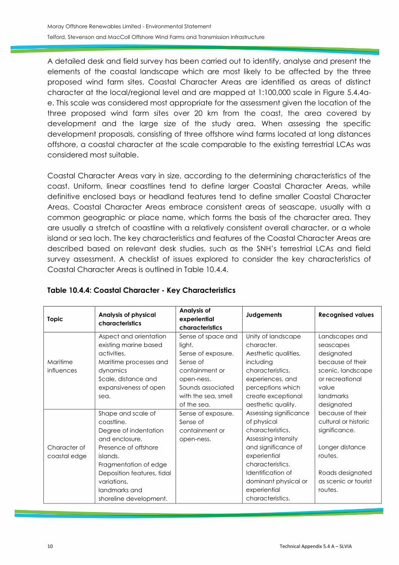
A detailed desk and field survey has been carried out to identify, analyse and present the elements of the coastal landscape which are most likely to be affected by the three proposed wind farm sites. Coastal Character Areas are identified as areas of distinct character at the local/regional level and are mapped at 1:100,000 scale in Figure 5.4.4a-e. This scale was considered most appropriate for the assessment given the location of the three proposed wind farm sites over 20 km from the coast, the area covered by development and the large size of the study area. When assessing the specific development proposals, consisting of three offshore wind farms located at long distances offshore, a coastal character at the scale comparable to the existing terrestrial LCAs was considered most suitable. Coastal Character Areas vary in size, according to the determining characteristics of the coast. Uniform, linear coastlines tend to define larger Coastal Character Areas, while definitive enclosed bays or headland features tend to define smaller Coastal Character Areas. Coastal Character Areas embrace consistent areas of seascape, usually with a common geographic or place name, which forms the basis of the character area. They are usually a stretch of coastline with a relatively consistent overall character, or a whole island or sea loch. The key characteristics and features of the Coastal Character Areas are described based on relevant desk studies, such as the SNH’s terrestrial LCAs and field survey assessment. A checklist of issues explored to consider the key characteristics of Coastal Character Areas is outlined in Table 10.4.4. Table 10.4.4: Coastal Character - Key Characteristics
Topic Analysis of physical characteristics
Analysis of experiential characteristics
Judgements
Recognised values
Maritime influences
Aspect and orientation existing marine based activities. Maritime processes and dynamics Scale, distance and expansiveness of open sea.
Sense of space and light. Sense of exposure. Sense of containment or open-ness. Sounds associated with the sea, smell of the sea.
Unity of landscape character. Aesthetic qualities, including characteristics, experiences, and perceptions which create exceptional aesthetic quality. Assessing significance of physical characteristics. Assessing intensity and significance of experiential characteristics. Identification of dominant physical or experiential characteristics.
Landscapes and seascapes designated because of their scenic, landscape or recreational value landmarks designated because of their cultural or historic significance. Longer distance routes. Roads designated as scenic or tourist routes.
Character of coastal edge
Shape and scale of coastline. Degree of indentation and enclosure. Presence of offshore islands. Fragmentation of edge Deposition features, tidal variations, landmarks and shoreline development.
Sense of exposure. Sense of containment or open-ness.
Moray Offshore Renewables Limited - Environmental Statement
Telford, Stevenson and MacColl Offshore Wind Farms and Transmission Infrastructure
10 Technical Appendix 5.4 A – SLVIA
A detailed desk and field survey has been carried out to identify, analyse and present the elements of the coastal landscape which are most likely to be affected by the three proposed wind farm sites. Coastal Character Areas are identified as areas of distinct character at the local/regional level and are mapped at 1:100,000 scale in Figure 5.4.4a-e. This scale was considered most appropriate for the assessment given the location of the three proposed wind farm sites over 20 km from the coast, the area covered by development and the large size of the study area. When assessing the specific development proposals, consisting of three offshore wind farms located at long distances offshore, a coastal character at the scale comparable to the existing terrestrial LCAs was considered most suitable. Coastal Character Areas vary in size, according to the determining characteristics of the coast. Uniform, linear coastlines tend to define larger Coastal Character Areas, while definitive enclosed bays or headland features tend to define smaller Coastal Character Areas. Coastal Character Areas embrace consistent areas of seascape, usually with a common geographic or place name, which forms the basis of the character area. They are usually a stretch of coastline with a relatively consistent overall character, or a whole island or sea loch. The key characteristics and features of the Coastal Character Areas are described based on relevant desk studies, such as the SNH’s terrestrial LCAs and field survey assessment. A checklist of issues explored to consider the key characteristics of Coastal Character Areas is outlined in Table 10.4.4. Table 10.4.4: Coastal Character - Key Characteristics
Topic Analysis of physical characteristics
Analysis of experiential characteristics
Judgements
Recognised values
Maritime influences
Aspect and orientation existing marine based activities. Maritime processes and dynamics Scale, distance and expansiveness of open sea.
Sense of space and light. Sense of exposure. Sense of containment or open-ness. Sounds associated with the sea, smell of the sea.
Unity of landscape character. Aesthetic qualities, including characteristics, experiences, and perceptions which create exceptional aesthetic quality. Assessing significance of physical characteristics. Assessing intensity and significance of experiential characteristics. Identification of dominant physical or experiential characteristics.
Landscapes and seascapes designated because of their scenic, landscape or recreational value landmarks designated because of their cultural or historic significance. Longer distance routes. Roads designated as scenic or tourist routes.
Character of coastal edge
Shape and scale of coastline. Degree of indentation and enclosure. Presence of offshore islands. Fragmentation of edge Deposition features, tidal variations, landmarks and shoreline development.
Sense of exposure. Sense of containment or open-ness.
Moray Offshore Renewables Limited - Environmental Statement
Telford, Stevenson and MacColl Offshore Wind Farms and Transmission Infrastructure
Technical Appendix 5.4 A – SLVIA 11
Character of immediate hinterland
Key elements of landscape character topography and relief vegetation pattern. Existing settlement pattern landmarks.
Sense of containment or open-ness. Presence of maritime influence.
Identification of aesthetic attributes. Determining the extent of the relevant setting for significant features and landmarks identifying relevant cultural associations with place
Wildness / isolated coast
Presence of natural processes. Presence of development/ human activity.Actual accessibility ruggedness of terrain.
Sense of naturalness perceived remoteness sense of isolation.
Intensity of sense of wildness degree of ruggedness and perceived accessibility. Degree to which natural processes dominate the experience of place.
Wild land search areas.
1.2.5 Stage Four: Undertake Sensitivity Analysis
The sensitivity of a Coastal Character Area is an expression of its ability to accommodate the three proposed wind farm sites as part of its own character or as part of the visual setting or context of the coastal character. This is dependent on the value, quality, existing character and position of the Coastal Character Area in relation to the three proposed wind farm sites as explained below:
The value of the Coastal Character Area is a reflection of its importance in terms of any designations that may apply, or as a landscape/seascape resource;
The quality of the Coastal Character Area is a reflection of its attributes, such as sense of place and scenic quality, and the extent to which attributes have remained intact;
The existing coastal character determines the degree to which the receptor may accommodate the influence of the development; and
The position of the Coastal Character Area in relation to the three proposed wind farm sites will influence its sensitivity to the change proposed and will vary according to whether they have a close/direct or distant/indirect relationship.
Levels of sensitivity – high, medium-high, medium and medium-low, low – are applied to each Landscape Type and Coastal Character Area. The sensitivity of each receptor is a product of the specific combination of value, quality and existing landscape character as evaluated for that receptor. It is not possible to provide definitions for each of the levels of sensitivity (low, medium-low, medium, medium-high and high) as the level of sensitivity of each receptor is a product of consideration of the factors specific to each receptor and the application of professional judgement. The combination of criteria and the resulting level of sensitivity are described in the evaluation of sensitivity for each receptor.

Moray Offshore Renewables Limited - Environmental Statement
Telford, Stevenson and MacColl Offshore Wind Farms and Transmission Infrastructure
12 Technical Appendix 5.4 A – SLVIA
1.2.6 Stage Five: Undertake Impact Assessment The significance of the effect on Coastal Character is dependent on the multiple factors considered in determining the sensitivity and the magnitude of change and by applying professional judgement to assess whether the three proposed wind farm sites will have an effect that is significant or not significant. A significant effect will occur where the combination of the variables results in the three proposed wind farm sites having a definitive effect on the receptor, so that its landscape character is redefined by the presence of the three proposed wind farm sites. A not significant effect will occur where the effect of the three proposed wind farm sites is not definitive, and the landscape character of the receptor continues to be defined principally by its baseline characteristics. The methodology for the impact assessment for the SLVIA is described fully in ES Section 11.3.9. 1.3 Visual Baseline The baseline assessment includes the identification and agreement of specific viewpoints identified during desk and field survey. Field survey was undertaken to identify and locate appropriate viewpoints for the visual assessment, and to shoot baseline photography to illustrate the existing views from viewpoints in the study area. An outline of the relevant issues considered when defining the baseline visual character is shown in Table 10.4.5. Table 10.4.5: Methodology for Coastal/Seascape Assessment: Visual Assessment
Topic Analysis of physical elements
Analysis of type of views
Judgements Recognised values
Visual assessment
Presence of the coastal edge. Presence of the open sea. Focal points or features within the views. Aspect and orientation of viewpoint, character of seascape.
Overlook from settled areas. Views experienced as part of a sequence. Elevated viewpoints panoramas. Sudden revelations. Glimpse views.
Significance of views and viewpoints. Significance and dominance of compositional elements. Quality of visual composition from viewpoints. Aspect and transient qualities such as quality of light and reflectivity.
Views which contribute to the experience of a landscape or seascape designated for its scenic quality. Views to and from features designated because of their historic significance. Views from longer distance routes. Views from popular recreational areas or specific facilities.
Moray Offshore Renewables Limited - Environmental Statement
Telford, Stevenson and MacColl Offshore Wind Farms and Transmission Infrastructure
Technical Appendix 5.4 A – SLVIA 13
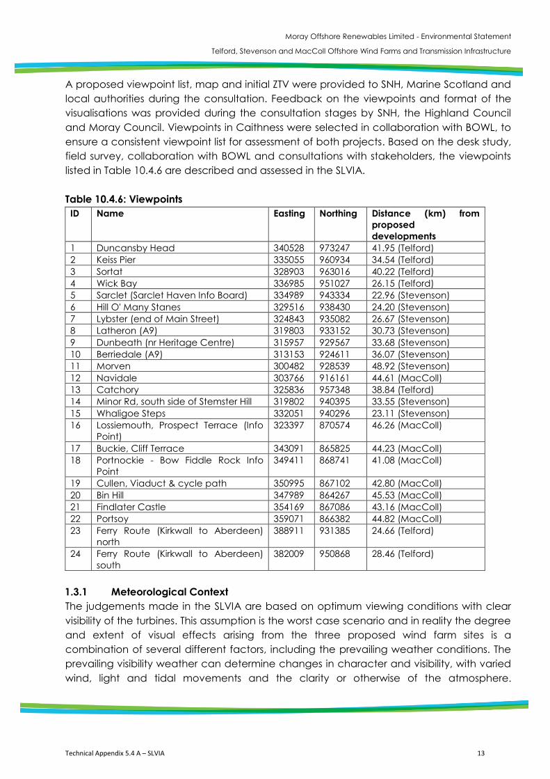
A proposed viewpoint list, map and initial ZTV were provided to SNH, Marine Scotland and local authorities during the consultation. Feedback on the viewpoints and format of the visualisations was provided during the consultation stages by SNH, the Highland Council and Moray Council. Viewpoints in Caithness were selected in collaboration with BOWL, to ensure a consistent viewpoint list for assessment of both projects. Based on the desk study, field survey, collaboration with BOWL and consultations with stakeholders, the viewpoints listed in Table 10.4.6 are described and assessed in the SLVIA. Table 10.4.6: Viewpoints ID Name Easting Northing Distance (km) from
proposed developments
1 Duncansby Head 340528 973247 41.95 (Telford) 2 Keiss Pier 335055 960934 34.54 (Telford) 3 Sortat 328903 963016 40.22 (Telford) 4 Wick Bay 336985 951027 26.15 (Telford) 5 Sarclet (Sarclet Haven Info Board) 334989 943334 22.96 (Stevenson) 6 Hill O' Many Stanes 329516 938430 24.20 (Stevenson) 7 Lybster (end of Main Street) 324843 935082 26.67 (Stevenson) 8 Latheron (A9) 319803 933152 30.73 (Stevenson) 9 Dunbeath (nr Heritage Centre) 315957 929567 33.68 (Stevenson) 10 Berriedale (A9) 313153 924611 36.07 (Stevenson) 11 Morven 300482 928539 48.92 (Stevenson) 12 Navidale 303766 916161 44.61 (MacColl) 13 Catchory 325836 957348 38.84 (Telford) 14 Minor Rd, south side of Stemster Hill 319802 940395 33.55 (Stevenson) 15 Whaligoe Steps 332051 940296 23.11 (Stevenson) 16 Lossiemouth, Prospect Terrace (Info
Point) 323397 870574 46.26 (MacColl)
17 Buckie, Cliff Terrace 343091 865825 44.23 (MacColl) 18 Portnockie - Bow Fiddle Rock Info
Point 349411 868741 41.08 (MacColl)
19 Cullen, Viaduct & cycle path 350995 867102 42.80 (MacColl) 20 Bin Hill 347989 864267 45.53 (MacColl) 21 Findlater Castle 354169 867086 43.16 (MacColl) 22 Portsoy 359071 866382 44.82 (MacColl) 23 Ferry Route (Kirkwall to Aberdeen)
north 388911 931385 24.66 (Telford)
24 Ferry Route (Kirkwall to Aberdeen) south
382009 950868 28.46 (Telford)
1.3.1 Meteorological Context The judgements made in the SLVIA are based on optimum viewing conditions with clear visibility of the turbines. This assumption is the worst case scenario and in reality the degree and extent of visual effects arising from the three proposed wind farm sites is a combination of several different factors, including the prevailing weather conditions. The prevailing visibility weather can determine changes in character and visibility, with varied wind, light and tidal movements and the clarity or otherwise of the atmosphere.
Moray Offshore Renewables Limited - Environmental Statement
Telford, Stevenson and MacColl Offshore Wind Farms and Transmission Infrastructure
14 Technical Appendix 5.4 A – SLVIA
Collectively, these will combine to reduce the number of days upon which views of the three proposed wind farm sites will be available from the coastline and hinterland, or to inhibit views of the three proposed wind farm sites, rendering them more visually recessive within the wider seascape. Although the SLVIA is based on clear visibility of the turbines, a baseline description of the visibility frequency is provided using METAR visibility data from Wick Airport, to highlight trends in the visibility conditions of the study area. Most synoptic observing stations have sensors which provide a measurement of visibility. Visibility sensors measure the meteorological optical range which is defined as the length of atmosphere over which a beam of light travels before its luminous flux is reduced to 5% of its original value. The use of light within the visible spectrum allows the sensor to most accurately simulate human perception of visibility. Reasonably accurate measurements are possible over a range of visibility extending from a few tens of metres to a few tens of kilometres. Visibility is categorised into distance ranges, such as <1km, 1 to 2km, 2 to 3km etc and a frequency table compiled revealing the total number of observations within each distance category at hourly intervals for each month. The data, summarised in Appendix 5.4 B, highlights trends in the visibility conditions of the study area, such as the distance category which has the most visibility observations recorded, and approximate number of viewing days lost to low visibility weather conditions. The Telford Wind Farm lies approximately 26 km from Wick; therefore the measurements at this distance are appropriate to reference when assessing the relative visibility of the development against the baseline visibility frequency data.
2. SLVIA Impact Assessment Methodology The baseline assessment methodology for the SLVIA is described in ES Chapter 5.4. The EIA methodology which follows sets out the methods for assessing the likely significant effects of the three proposed wind farm sites and relates to Stage 4 and 5 of the approach outlined in ES Chapter 5.4. The methodology used to carry out the SLVIA has been developed by Optimised Environments Ltd (OPEN) for the SLVIA of wind farms and accords with current best practice guidance (LI/IEMA, 2002). The methodology for the SLVIA draws on guidance from several other reference documents listed in ES Chapter 5.4. The SLVIA is based on the Rochdale Envelope described in Section 2 (Project Description). The parameters relevant to the SLVIA are set out in ES Chapter 8.4. In compliance with EIA regulations, the likely ‘worst case’ scenario is assessed and illustrated in the SLVIA.
Moray Offshore Renewables Limited - Environmental Statement
Telford, Stevenson and MacColl Offshore Wind Farms and Transmission Infrastructure
Technical Appendix 5.4 A – SLVIA 15
The SLVIA for the offshore generating stations has been undertaken within a 50 km radius study area of the Telford, Stevenson and MacColl wind farms as shown in Figure 5.4-1. The reason for the use of this size of study area is described in the baseline study methodology in ES Chapter 5.4. of this Appendix. The study area is not intended to provide a boundary beyond which the three proposed wind farm sites will not be seen, but rather to define the area within which to assess the potential significant landscape and visual effects of the three proposed wind farm sites. 2.1 Landscape Effects: Physical The assessment of physical landscape effects determines the likely physical effects of the three proposed wind farm sites on landscape elements that are located in the development area. Landscape elements are the component parts of the landscape such as landcover, hedgerows and trees. Physical landscape effects will result from the onshore export cable and onshore convertor station. Physical seascape effects of the offshore generating station, e.g. on the sea bed, are not assessed in this chapter. 2.1.1 Sensitivity Criteria The sensitivity of a landscape element is an expression of its value and quality, and the potential for mitigation of the effect as explained below:
The value of a landscape element is a reflection of its importance in the pattern of elements that constitutes the landscape character of the area and the policy or designations that might apply to it;
The quality of a landscape element is a reflection of its condition and state of repair; and
The potential for mitigation of the effect on a landscape element is a reflection of the degree to which the element can be restored, replaced or substituted.
Levels of sensitivity – high, medium-high, medium and medium-low, low – are applied. The sensitivity of each receptor is a product of the specific combination of value, quality and existing landscape character as evaluated for that receptor. 2.1.2 Magnitude Criteria The magnitude of change on landscape elements is quantifiable, and will be expressed in terms of the degree to which a landscape element will be removed or altered by the three proposed wind farm sites. Definitions of the levels of magnitude of change are defined as follows:
Moray Offshore Renewables Limited - Environmental Statement
Telford, Stevenson and MacColl Offshore Wind Farms and Transmission Infrastructure
16 Technical Appendix 5.4 A – SLVIA
High, where the three proposed wind farm sites will result in the complete removal or alteration of a key landscape element, or the addition of a major new landscape element;
Medium, where the three proposed wind farm sites will result in the removal of a notable part of a landscape element, a notable alteration to a landscape element, or the addition of a notable new landscape element;
Low, where the three proposed wind farm sites will result in the removal of a minor part of an element, a minor alteration to a landscape element, or the addition of a minor new landscape element; and
Negligible, where the change resulting from the three proposed wind farm sites is barely discernible and equates to a ‘no change’ situation.
Intermediate levels of magnitude may also be included.
2.1.3 Significance The significance of the effect on landscape elements is dependent on the multiple factors considered in determining the sensitivity and the magnitude of change and by applying professional judgement to assess whether or not the three proposed wind farm sites will have an effect that is significant or not significant. A significant effect will occur where the degree of removal or alteration of the landscape element is such that the form of the element will be redefined. Where a landscape element has a high sensitivity, a significant effect can occur with a limited degree of removal or alteration. If the landscape element is of lower sensitivity, it may undergo a relatively high level of removal or alteration yet remain as a not significant effect.
2.2 Effects on Seascape and Landscape Character Effects on seascape and landscape character arise either through the introduction of new elements that physically alter the pattern of elements in a seascape or landscape, or through visibility of the three proposed wind farm sites, which may alter the way in which the pattern of elements is perceived. The objective of the assessment is to determine the likely effects of the three proposed wind farm sites on seascape and landscape character. Seascape and landscape character receptors are the defined coastal character areas and landscape character types and those areas that have been designated for their recognised quality or value in landscape planning terms, such as the Historic Gardens and Designed Landscapes (GDLs).
2.2.1 Sensitivity Criteria
The sensitivity of a landscape character receptor is an expression of its ability to accommodate the three proposed wind farm sites as part of its own character or as part of the visual setting or context of the character receptor. This is dependent on the value, quality, existing landscape character and position of the receptor in relation to the three proposed wind farm sites as explained below:
Moray Offshore Renewables Limited - Environmental Statement
Telford, Stevenson and MacColl Offshore Wind Farms and Transmission Infrastructure
Technical Appendix 5.4 A – SLVIA 17
The value of a landscape character receptor is a reflection of its importance in terms of any designations that may apply, or as a landscape resource;
The quality of a landscape character receptor is a reflection of its attributes, such as sense of place and scenic quality, and the extent to which these attributes have remained intact;
The existing landscape character of the receptor determines the degree to which the receptor may accommodate the influence of the development; and
The position of the landscape character receptor in relation to the three proposed wind farm sites will influence its sensitivity to the change proposed and will vary according to whether they have a close/direct or distant/indirect relationship.
Levels of sensitivity – high, medium-high, medium and medium-low, low – are applied. The sensitivity of each receptor is a product of the specific combination of value, quality and existing landscape character as evaluated for that receptor. It is not possible to provide definitions for each of the levels of sensitivity (low, medium-low, medium, medium-high and high) as the level of sensitivity of each receptor is a product of consideration of the factors specific to each receptor and the application of professional judgement. The combination of criteria and the resulting level of sensitivity will be described in the evaluation of sensitivity for each receptor. 2.2.2 Magnitude Criteria The magnitude of change on seascape and landscape character receptors is an expression of the scale of the change that will result from the three proposed wind farm sites, and will be dependent on the following variables:
Degree to which the pattern of elements that makes up character will be altered, either physically or visually by the three proposed wind farm sites;
Extent to which the three proposed wind farm sites become a characteristic element or key characteristic of the seascape/landscape character;
Distance between the seascape/landscape character receptor and the three proposed wind farm sites;
Extent of the receptor that will be affected by visibility and, therefore, the influence of the three proposed wind farm sites;
Extent of the three proposed wind farm sites that will be seen; Position of the three proposed wind farm sites in relation to the principal orientation
of the landscape character receptor; Scale comparisons; The appearance of the three proposed wind farm sites in relation to its setting; and Influences through which the receptor gains its character (such as the degree of
development that occurs either within or beyond the boundary of the landscape character receptor).
Moray Offshore Renewables Limited - Environmental Statement
Telford, Stevenson and MacColl Offshore Wind Farms and Transmission Infrastructure
18 Technical Appendix 5.4 A – SLVIA
Definitions of the levels of magnitude of change are defined as follows:
High, the three proposed wind farm sites will result in a major alteration to the baseline characteristics of the seascape/landscape, providing the prevailing influence and/or introducing elements that are substantially uncharacteristic in the receiving landscape;
Medium, the three proposed wind farm sites will result in a moderate alteration to the baseline characteristics of the seascape/landscape, providing a readily apparent influence and/or introducing elements that may be prominent but are not uncharacteristic in the receiving landscape;
Low, the three proposed wind farm sites will result in a minor alteration to the baseline characteristics of the seascape/landscape, providing a slightly apparent influence and/or introducing elements that are characteristic in the receiving landscape; and
Negligible, the three proposed wind farm sites will result in a negligible alteration to the baseline characteristics of the seascape/landscape, providing a barely discernible influence and/or introducing elements that are substantially characteristic in the receiving landscape.
Intermediate levels of magnitude may also be included and magnitude of change may be none where the three proposed wind farm sites are not visible. 2.2.3 Significance The significance of the effect on seascape/landscape character is dependent on the multiple factors considered in determining the sensitivity and the magnitude of change and by applying professional judgement to assess whether the three proposed wind farm sites will have an effect that is significant or not significant. A significant effect will occur where the combination of the variables results in the three proposed wind farm sites having a definitive effect on the receptor, so that its seascape/landscape character is redefined by the presence of the three proposed wind farm sites. A not significant effect will occur where the effect of the three proposed wind farm sites is not definitive, and the seascape/landscape character of the receptor continues to be defined principally by its baseline characteristics. 2.3 Visual Effects The objective of the visual assessment is to determine the likely effects of the three proposed wind farm sites on views and visual receptors. Visual receptors are the defined viewpoints and visual receptors, such as settlements, road and footpaths, identified in the baseline study.
Moray Offshore Renewables Limited - Environmental Statement
Telford, Stevenson and MacColl Offshore Wind Farms and Transmission Infrastructure
Technical Appendix 5.4 A – SLVIA 19
2.3.1 Sensitivity Criteria
The sensitivity of a view is an expression of its ability to accommodate the three proposed wind farm sites, and is dependent on the importance of the viewpoint, the value of the view, and the nature of the viewer, explained as follows:
The importance of the viewpoint is determined by any recognition that the viewpoint may have, such as being marked on a map or with interpretation. The greater the importance of the viewpoint, the greater its sensitivity is likely to be;
The value of the view is a reflection of the scenic qualities of the view and will also be increased if it lies within or overlooks a designated area such as a regional scenic area (which implies a greater value to the visible landscape). The greater the value of the view, the greater its sensitivity is likely to be; and
The nature of the viewer reflects the occupation or activity of the people who will gain the view. Viewers whose attention is focused on the landscape – walkers, for example – are likely to have a higher sensitivity, as will residents of properties that gain views of the development. Viewers travelling in cars or on trains, or those at work, will tend to have a lower sensitivity as their view is either transient or they are engaged in other activities.
Levels of sensitivity – high, medium-high, medium and medium-low, low – are applied. The sensitivity of each receptor is a product of the specific combination of the importance of the viewpoint, value of the view and nature of the viewer. 2.3.2 Magnitude Criteria
The magnitude of change on views is an expression of the scale of the apparent change that will result from the three proposed wind farm sites, and is dependent on the following variables:
The distance between the viewpoint/visual receptor and the three proposed wind farm sites;
The extent of the receptor with visibility of the three proposed wind farm sites; The amount of the three proposed wind farm sites that will be seen; The context within which the three proposed wind farm sites will be seen; The proportion of the view that is affected by the three proposed wind farm sites; The position of the three proposed wind farm sites in relation to the principal
orientation of the view; Scale comparisons arising from the three proposed wind farm sites with other
features in the existing view; The integration or relationship between the three proposed wind farm sites and
other wind farms; The frequency and duration of views available (e.g. From a road or route); and The direction of view: whether it is in the main outlook, oblique to or behind the
viewer.
Moray Offshore Renewables Limited - Environmental Statement
Telford, Stevenson and MacColl Offshore Wind Farms and Transmission Infrastructure
20 Technical Appendix 5.4 A – SLVIA
Definitions of the four levels of magnitude of change are defined as follows: High, the three proposed wind farm sites will result in a major alteration to the
baseline view, providing the prevailing influence and/or introducing elements that are substantially uncharacteristic in the receiving view;
Medium, the three proposed wind farm sites will result in a moderate alteration to the baseline view, providing a readily apparent influence and/or introducing elements that may be prominent but are not uncharacteristic in the receiving view;
Low, the three proposed wind farm sites will result in a minor alteration to the baseline view, providing a slightly apparent influence and/or introducing elements that are characteristic in the receiving view; and
Negligible, the three proposed wind farm sites will result in a negligible alteration to the baseline view, providing a barely discernible influence and/or introducing elements that are substantially characteristic in the receiving view.
Intermediate levels of magnitude may also be included and magnitude of change may be none where the three proposed wind farm sites are not visible.
2.3.3 Significance
The significance of the effect on views is dependent on the multiple factors considered in determining the sensitivity and the magnitude of change and by applying professional judgement to assess whether or not the three proposed wind farm sites will have an effect that is significant or not significant. A significant effect will occur where the combination of the variables results in the three proposed wind farm sites having a material effect on the view, so that its appearance is redefined by the presence of the three proposed wind farm sites. A not significant effect will occur where the appearance of the three proposed wind farm sites is not definitive, and the view continues to be defined principally by its baseline characteristics. In this instance the three proposed wind farm sites may affect the appearance of the view, but this effect will not result in a material change.
This assessment assumes clear weather and optimum viewing conditions. This means that effects that are assessed to be significant may be not-significant under different, less clear conditions. Viewing conditions and visibility have been found to vary widely at the development site, and the effects of the wind farm will vary greatly according to the weather. 2.4 Assessing the Significance of Seascape, Landscape and Visual Effects
OPEN’s methodology for assessing wind farm development is not reliant on the use of a matrix to determine the significance of seascape, landscape and visual effects, nor does it define levels of significance. In accordance with the Electricity Works (Environmental impact Assessment) (Scotland) Regulations 2000 it identifies whether effects are likely to be significant or not. It is however considered useful to include a matrix in the methodology to help illustrate how combinations of sensitivity and magnitude of change can give rise to a significant effect and to provide an understanding as to the threshold at which significant effects may arise. Table 10.4.7 below provides this illustration.
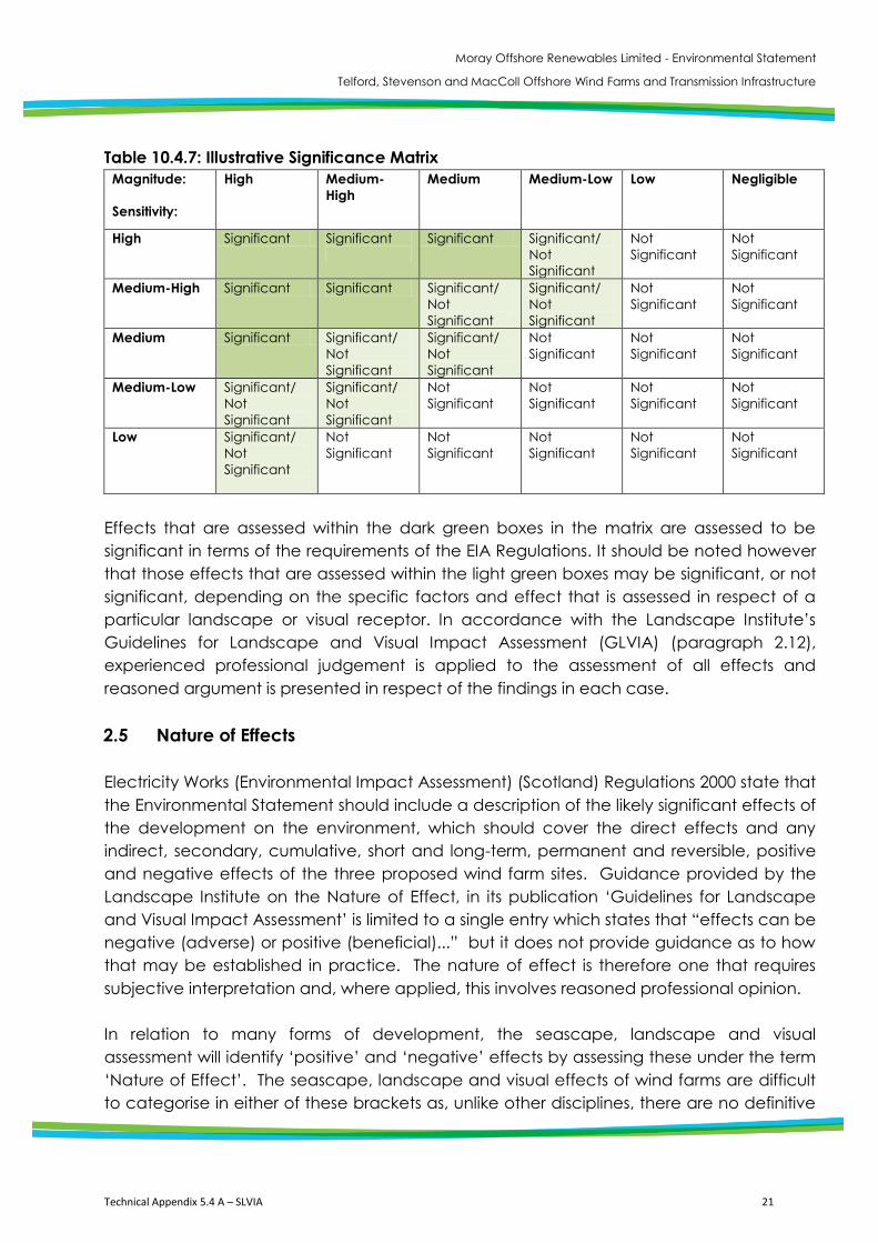
Moray Offshore Renewables Limited - Environmental Statement
Telford, Stevenson and MacColl Offshore Wind Farms and Transmission Infrastructure
Technical Appendix 5.4 A – SLVIA 21
Table 10.4.7: Illustrative Significance Matrix
Magnitude: Sensitivity:
High Medium-High
Medium Medium-Low Low Negligible
High Significant Significant
Significant Significant/ Not Significant
Not Significant
Not Significant
Medium-High Significant Significant Significant/ Not Significant
Significant/ Not Significant
Not Significant
Not Significant
Medium Significant Significant/ Not Significant
Significant/ Not Significant
Not Significant
Not Significant
Not Significant
Medium-Low Significant/ Not Significant
Significant/ Not Significant
Not Significant
Not Significant
Not Significant
Not Significant
Low Significant/ Not Significant
Not Significant
Not Significant
Not Significant
Not Significant
Not Significant
Effects that are assessed within the dark green boxes in the matrix are assessed to be significant in terms of the requirements of the EIA Regulations. It should be noted however that those effects that are assessed within the light green boxes may be significant, or not significant, depending on the specific factors and effect that is assessed in respect of a particular landscape or visual receptor. In accordance with the Landscape Institute’s Guidelines for Landscape and Visual Impact Assessment (GLVIA) (paragraph 2.12), experienced professional judgement is applied to the assessment of all effects and reasoned argument is presented in respect of the findings in each case. 2.5 Nature of Effects Electricity Works (Environmental Impact Assessment) (Scotland) Regulations 2000 state that the Environmental Statement should include a description of the likely significant effects of the development on the environment, which should cover the direct effects and any indirect, secondary, cumulative, short and long-term, permanent and reversible, positive and negative effects of the three proposed wind farm sites. Guidance provided by the Landscape Institute on the Nature of Effect, in its publication ‘Guidelines for Landscape and Visual Impact Assessment’ is limited to a single entry which states that “effects can be negative (adverse) or positive (beneficial)...” but it does not provide guidance as to how that may be established in practice. The nature of effect is therefore one that requires subjective interpretation and, where applied, this involves reasoned professional opinion. In relation to many forms of development, the seascape, landscape and visual assessment will identify ‘positive’ and ‘negative’ effects by assessing these under the term ‘Nature of Effect’. The seascape, landscape and visual effects of wind farms are difficult to categorise in either of these brackets as, unlike other disciplines, there are no definitive
Moray Offshore Renewables Limited - Environmental Statement
Telford, Stevenson and MacColl Offshore Wind Farms and Transmission Infrastructure
22 Technical Appendix 5.4 A – SLVIA
criteria by which the effects of wind farms can be measured as being categorically ‘positive’ or ‘negative’. In some disciplines, such as noise or ecology, it is possible to quantify the effect of a wind farm in numeric terms, by objectively identifying or quantifying the proportion of a receptor that is affected by the development, and assessing the nature of that effect in justifiable terms. However, this is not the case in relation to seascape, landscape and visual effects where the approach combines quantitative and qualitative assessment.
The attribution of positive and negative nature of effects is used inconsistently by landscape professionals when preparing SLVIAs for wind farms and there is not a consensus of opinion that supports its use for wind farm assessments. Generally, in the development of ‘new’ wind farms, a precautionary approach that assumes that significant landscape and visual effects will be weighed on the negative side of the planning balance.
However, in the assessment of a wind farm that will appear as an extension, the nature of effects on some seascape, landscape and visual receptors may be found to be ‘neutral’, with the neutral category lying on a scale between positive and negative effects. A neutral effect will occur where the development can be accommodated in the receiving environment with neither beneficial nor adverse effects. The relationship of the proposed extension to the existing wind farm will be the principal determinant in this case.
Where defined in this assessment, the nature of effect is assessed in the context of potential wind farm development at the site and how it relates to the features and context of the seascape/landscape or view. The nature of effect is impartially defined in relation to specific definitions for beneficial, neutral or adverse effects as follows:
Beneficial effects contribute to the seascape, landscape and visual resource through the enhancement of desirable characteristics or the introduction of new, positive attributes. The removal of undesirable existing elements or characteristics can also be beneficial, as can their replacement with more appropriate components;
Neutral effects occur where the development neither contributes to nor detracts from the seascape, landscape and visual resource or where the effects are so limited that the change is hardly noticeable. A change to the landscape and visual resource is not considered to be adverse simply because it constitutes an alteration to the existing situation. Neutral effects may arise where the effect of the three proposed wind farm sites is neither overtly beneficial or adverse, where it achieves a suitable relationship with the seascape/landscape or view, all things considered; and
Adverse effects are those that detract from or weaken the seascape/landscape and visual resource through the introduction of elements that contrast, in a detrimental way, with the existing characteristics of the landscape and visual resource, or through the removal of elements that are key in its characterisation.
Moray Offshore Renewables Limited - Environmental Statement
Telford, Stevenson and MacColl Offshore Wind Farms and Transmission Infrastructure
Technical Appendix 5.4 A – SLVIA 23
Judgements on the nature of effect are based on professional experience and reasoned opinion informed by best practice guidance. 2.6 Duration, Reversibility and Likelihood The effects of the three proposed wind farm sites are of variable duration, and are assessed as short-term or long-term, and permanent or reversible. It is proposed that the operational life of the wind farm will be 25 years (though towards the end of this operational period, project re-powering may be considered in order to extend the operational life to 50 years) The offshore wind turbine generators, offshore substation platforms and permanent meteorological masts will be apparent during this time. These effects are considered to be long-term. Other operations such as the installation of the offshore wind turbine generators will be apparent only during the initial construction phase of the development, and are considered to be short-term effects. The reversibility of effects is variable. The major effects on the seascape, landscape and visual resource, which result from the presence of the turbines, are reversible as the turbines will be removed at decommissioning. The effects that will occur during the construction period and decommissioning of the site from the use of installation vessels and jack-up barges are also reversible as they are only required temporarily. Permanent effects include physical removal of existing landscape elements, required for the development of the site, and any residual effects that remain following restoration. Decommissioning will not involve removing the site tracks or underground cabling. No permanent landscape and visual effects will result from the onshore cable export route. In order to avoid repetition, the duration and reversibility of effects are not reiterated throughout the assessment. The SLVIA includes an assessment of the likelihood of effects occurring in relation to the prevailing visibility conditions. The judgements made in the SLVIA are based on optimum viewing conditions with clear visibility of the turbines. This assumption is the worst case scenario and in reality, the likelihood of visual effects arising from the three proposed wind farm sites is a combination of several different factors, including the prevailing visibility conditions. The assessment includes an indication of the likelihood of effects occurring at different distances based on analysis of Met Office visibility frequency data.
3. Methodology for the Assessment of Cumulative Effects Cumulative (seascape, landscape and visual) effects may be defined as the additional changes caused by the three proposed wind farm sites in conjunction with other similar developments or as the combined effect of a set of developments taken together. The objective of the Cumulative Seascape, Landscape and Visual Impact Assessment

Moray Offshore Renewables Limited - Environmental Statement
Telford, Stevenson and MacColl Offshore Wind Farms and Transmission Infrastructure
24 Technical Appendix 5.4 A – SLVIA
(CSLVIA) is to describe, visually represent and assess the ways in which the three proposed wind farm sites will have additional effects when considered together with other existing, consented or proposed wind farms and to identify related significant cumulative effects arising from the three proposed wind farm sites. The degree to which cumulative effects occur, or may occur, as a result of more than one wind farm project being constructed are a result of:
The distance between individual wind farms; The interrelationship between their zones of theoretical visibility (ZTV); The overall character of the landscape and its sensitivity to wind farms; The siting and design of the wind farms themselves; and The way in which the landscape is experienced.
3.1 Cumulative Effect Scenarios Three scenarios are assessed in the cumulative assessment. The main SLVIA assesses the effect of the three proposed wind farm sites in addition to those already present (operational) in the landscape. This first scenario therefore involves the assessment of the addition of the three proposed wind farm sites to the existing baseline as part of the main LVIA, which includes the operational onshore Achairn, Boyndie, Causeymire and Flex Hill Wind farms in Caithness, Boyndie Wind Farm in Aberdeenshire and the offshore Beatrice Demonstrator turbines. The second scenario involves the assessment of the addition of the three proposed wind farm sites to existing wind farms (identified in the first scenario) and other wind farms which have been granted planning consent (i.e. approved schemes which are likely to be constructed). The consented wind farms at Burn of Whilk, Causeymore Extension, Stroupster and Wathegar are considered. The third scenario involves the assessment of the addition of the three proposed wind farm sites to existing and consented wind farms (identified in the first and second scenario), together with valid (but as yet undetermined) wind energy planning applications. The Beatrice Offshore Wind Farm (BOWL) is considered as an application stage site in the assessment, together with several onshore application stage wind farms in Caithness. In the application scenario, the cumulative effect of the three proposed wind farm sites are assessed in the context of onshore wind farms and offshore wind farms, so that the cumulative effect of the three proposed wind farm sites can be considered with and without Beatrice. Scoping stage wind farms are not included in the assessment, because of difficulty in gathering information and the high chance of any initial layouts being changed or applications not being submitted. The location of scoping stage sites are mapped in Figure 15.4-1 and indicated in the cumulative wirelines in Figures 15.4-23 to 15.4-46. The
Moray Offshore Renewables Limited - Environmental Statement
Telford, Stevenson and MacColl Offshore Wind Farms and Transmission Infrastructure
Technical Appendix 5.4 A – SLVIA 25
cumulative situation changes frequently as applications are made or withdrawn, and the layouts of submitted application wind farms are changed. It is therefore necessary to decide on a cut-off date when the sites and layouts to be included are fixed. March 31st 2012 has been used as a cut-off for this cumulative assessment. Any changes in the cumulative situation after this date are not incorporated in the assessment. 3.2 Types of Cumulative Effect The aim of the cumulative assessment is to identify the additional changes which would be brought about by the three proposed wind farm sites when considered in conjunction with other wind farms. The CSLVIA is not required to examine the total effect arising from a number of developments, but to look at the potentially additional effects, e.g. due to the relationship between developments being discordant, and potentially reduced effects e.g. due to the relationship between developments being complementary. Two or more adjacent developments may complement one another, or may be discordant with one another, and it is the increased or reduced level of significance of effects which arises as a result of this change that is assessed in the cumulative assessment. The cumulative assessment covers the potential cumulative effects on seascape/landscape character and visual amenity. Cumulative effects on seascape/landscape character arise when two or more wind farms, through the introduction of new landscape features, change the key characteristics of a seascape/landscape or change it to such an extent that they create a different ‘wind farm’ seascape/landscape type. Wind farms may also have a cumulative effect on the character of landscapes that are designated for their landscape value. Wind farm proposals in nationally designated landscapes tends to be rare, therefore cumulative effects on the character of designated landscapes tend to be indirect. Cumulative effects on visual amenity consist of combined visibility and sequential effects. Combined visibility occurs where the observer is able to see two or more developments from one viewpoint. Combined visibility may either be ‘in combination’, where several wind farms are within the observer’s main angle of view at the same time, or ‘in succession’, where the observer has to turn to see the various wind farms. Sequential effects occur when the observer has to move to another viewpoint to see different developments. Sequential effects are assessed along regularly used routes such as major roads, railway lines and footpaths. The occurrence of sequential effects range from ‘frequently sequential’ (the features appear regularly and with short time lapses between, depending on speed of travel and distance between the viewpoints) to ‘occasionally sequential’ (long time lapses between appearances, because the observer is moving slowly and/or there are large distances between the viewpoints).
Moray Offshore Renewables Limited - Environmental Statement
Telford, Stevenson and MacColl Offshore Wind Farms and Transmission Infrastructure
26 Technical Appendix 5.4 A – SLVIA
3.3 Wind farms Included in Cumulative Assessment As a starting point to defining the scope of the cumulative assessment, operational, consented and proposed wind energy developments within the study area were mapped, as shown in Figure 15.4-1. Domestic scale wind turbines, with a height less than 20 metres to blade tip, have been scoped out of the assessment as it is considered that the three proposed wind farm sites will not have significant effects in addition to these small scale turbines. Small scale, single turbines developments have been scoped out of the assessment during consultations with The Highland Council, which recommended the CSLVIA focus on commercial scale wind farms, particularly onshore wind farms along the eastern coast of Caithness and offshore wind farms in the Moray Firth. An initial assessment of the relationship and intervisibility of these wind farms with the three proposed wind farm sites was then undertaken, in order to determine which wind farms have the potential to contribute to a significant cumulative effect following the addition of the three proposed wind farm sites. The assessment focuses on the sites with potential for significant cumulative effects with the three proposed wind farm sites. 3.4 Cumulative Magnitude of Change The cumulative magnitude of change on views is an expression of the degree to which the seascape/landscape character receptors and views will be changed by the addition of the three proposed wind farm sites to wind farms that are already existing, consented or proposed and is dependent on the following variables:
The location of the three proposed wind farm sites in relation to other wind farms; The extent of the developed skyline; The number and scale of the developments seen simultaneously, successively or
sequentially; The turbine size or scale comparison with other wind farms; The ‘consistency of image’ of the three proposed wind farm sites in relation to other
wind farms; The distance of the three proposed wind farm sites from the viewpoint or receptor;
and The magnitude of change of the three proposed wind farm sites in its own right.
Definitions of the four levels of magnitude of change are defined as follows:
High, where the addition of the three proposed wind farm sites will result in a major cumulative addition and make an immediately apparent contribution to the cumulative situation in a seascape/landscape receptor or view;
Medium, where the addition of the three proposed wind farm sites will result in a moderate cumulative addition and make a notable contribution to the cumulative
Moray Offshore Renewables Limited - Environmental Statement
Telford, Stevenson and MacColl Offshore Wind Farms and Transmission Infrastructure
Technical Appendix 5.4 A – SLVIA 27
situation, and its cumulative addition is readily apparent; Low, where the addition of the three proposed wind farm sites will result in a minor
cumulative addition and make a minor contribution to the overall cumulative situation, and its cumulative addition is only slightly apparent; and
Negligible, where the addition of the three proposed wind farm sites will result in a negligible cumulative addition and make a negligible contribution to the cumulative situation and its addition equates to a ‘no change’ situation.
There may also be intermediate levels of magnitude of change where the change falls between two of the definitions. 3.5 Significance of Cumulative Effects As with the assessment of effects of the three proposed wind farm sites itself, the significance of cumulative effects is determined through a combination of the sensitivity of the seascape/landscape receptor or view and the magnitude of change upon it. The sensitivity of seascape/landscape receptors and views is the same in the cumulative assessment as it is in the assessment of the site itself. However, the definition of a significant cumulative effect is different from a significant effect in the assessment of the site itself, and this means that the magnitude of change is also assessed in a different way. The objective of the cumulative assessment is to determine whether any effects that the three proposed wind farm sites will have on views and landscape character receptors when seen or perceived in conjunction with other existing and proposed sites will be significant or not significant. Significant cumulative effects therefore arise where a wind farm seascape or landscape is created as a result of the addition of the three proposed wind farm sites to other existing or proposed wind farms, which results in wind turbines becoming so prolific that they become the prevailing seascape/landscape characteristic. The creation of a wind farm seascape or landscape may evolve as follows:
A small scale, single wind farm will often be perceived as a new or ‘one-off’ landscape feature or landmark within the seascape/landscape. Except at a local site level, it usually cannot change the overall existing seascape/landscape character, or become a new characteristic element of a landscape;
With the addition of further wind farm development, wind farms can become a characteristic element of the seascape/landscape, as the wind farms appear as elements or components that are repeated. Providing there was sufficient ‘space’ or undeveloped landscape/skyline between each development, or the overlapping of several wind farms was not too dense; the developments would appears as a series of wind farms within the seascape/landscape and would not necessarily become the dominant or defining characteristic of the seascape/landscape nor have significant cumulative effects; and
The next stage would be to consider larger commercial wind farms and or an
Moray Offshore Renewables Limited - Environmental Statement
Telford, Stevenson and MacColl Offshore Wind Farms and Transmission Infrastructure
28 Technical Appendix 5.4 A – SLVIA
increase in the number of wind farms within an area that either overlap or coalesce and/or ‘join-up’ along the skyline. The effect is to create a ‘wind farm seascape/landscape’ where the wind farm element is the prevailing or defining characteristic of the seascape/landscape. The result would be to change the existing seascape/landscape character of a landscape type, or the seascape/landscape in a view (often resulting in a ‘with wind farm’ seascape/landscape type description) and resulting in a significant cumulative effect. A wind farm seascape/landscape may already exist as part of the baseline environment.
Less extensive, but nevertheless significant cumulative effects may also arise as a result of the addition of the three proposed wind farm sites, where it results in a seascape/landscape or view becoming defined by the presence of more than one wind farm, so that other patterns and components are no longer definitive, or where the three proposed wind farm sites contrasts with the scale or design of an existing or proposed wind farm. If the three proposed wind farm sites itself is assessed to have a significant effect on a seascape/landscape character receptor or view, it does not necessarily follow that the cumulative effect will also be significant. If the joint effect of the two or more wind farms does not result in the perception of a wind farm-defined seascape/landscape, or notable visual differences between wind farms, the cumulative effect will not be significant, even if the effect of the three proposed wind farm sites itself is significant.
3.6 Graphic Techniques 3.6.1 Zone of Theoretical Visibility (ZTV) A Zone of Theoretical Visibility (ZTV) diagram has been generated using Geographic Information System (GIS) software (ESRI ArcGIS Version 9.3) to demonstrate the number of turbines that may theoretically be seen from any point in the study area. The Blade Tip ZTV, shown in Figures 8.4-5, shows the number of turbines (blade tips) that are theoretically visible around the study area. The hub height ZTV, shown in Figure 8.4-6, shows the number of turbine hubs theoretically visible in the study area. When used in conjunction with the blade tip ZTV, the hub height ZTV provides an indication of the amount of the offshore wind turbine generators that may be visible. There are limitations in this theoretical production, and these should be considered in the interpretation and use of the ZTV:
Firstly, the ZTV illustrates the ‘bare ground’ situation, and does not take into account the screening effects of vegetation, buildings, or other local features that may prevent or reduce visibility;
The ZTV is based on a 50 m data grid (Ordnance Survey (OS) Panorama Digital Terrain Model (DTM)) and therefore does not pick up subtle changes in the landform for the wider study area, which may result in minor inaccuracies in the
Moray Offshore Renewables Limited - Environmental Statement
Telford, Stevenson and MacColl Offshore Wind Farms and Transmission Infrastructure
Technical Appendix 5.4 A – SLVIA 29
analysis; Thirdly, the ZTV does not indicate the decrease in visibility that occurs with
increased distance from the three proposed wind farm sites. The nature of what is visible from 3 km away will differ markedly from what is visible from 10 km away, although both are indicated on the ZTV has having the same level of visibility; and
Finally, it is important to remember that there is a wide range of variation within the visibility shown on the ZTV, for example, an area shown on the blade tip ZTV as having visibility of 201 - 216 turbines may gain views of the smallest extremity of blade tips, or of 216 full turbines. This can make a considerable difference in the effects of the development on that area. The hub height ZTV should be used in conjunction with the blade tip ZTV to provide an indication of the amount of the wind turbine generators that are visible.
These limitations mean that while the ZTV is used as a starting point in the assessment, providing an indication of where the three proposed wind farm sites will theoretically be visible, the information drawn from the ZTV is checked in the field, to ensure that the assessment conclusions represent the visibility of the three proposed wind farm sites reasonably accurately.
The SLVIA includes a Horizontal Angle ZTV in Figure 8.4-7 and a Vertical Angle ZTV in Figure 8.4-8. These have been generated using openWind software and the same data as the other ZTVs. These ZTVs show the horizontal and vertical field of view (in degrees) that may be affected by views of the turbines. There may be small discrepancies between the areas affected by theoretical visibility when compared with the Blade Tip ZTV. These occur around the edges of the plotted areas where the field of view that may be affected by theoretical visibility of one small blade tip in the ZTV is not picked up by the horizontal or vertical angle ZTV. This appears to be as a result of the different analytical processes used by the software to generate this information. This discrepancy is not considered material. As with the Blade Tip ZTV analysis, the Horizontal and Vertical Angle ZTVs are a helpful starting point for assessment. 3.6.2 Visualisations The viewpoint assessment is illustrated by a range of tools including photographs and photomontages. These visualisations are produced in accordance with SNH Good Practice Guidance (SNH, 2006), Landscape Institute Advice Note 01/11 (Landscape Institute, 2011). A selection of key viewpoints are presented to also accord with The Highland Council’s Visualisation Standards (The Highland Council, January 2010). The modelling methodology for the photomontage visualisations is summarised as follows.
Moray Offshore Renewables Limited - Environmental Statement
Telford, Stevenson and MacColl Offshore Wind Farms and Transmission Infrastructure
30 Technical Appendix 5.4 A – SLVIA
3.6.2.1 Software Packages Used
Resoft Windfarm v.4.2.1.6; Adobe Photoshop CS5.5 & Adobe Indesign CS5.5; PTGUI v9.2 Pro; ESRI ArcGIS v10; and AutoCAD Map 3D 2011.
3.6.2.2 Camera Information
Canon EOS 5D Mark II Digital SLR camera with a fixed 50 mm lens; Camera set to RAW image format; Nodal Ninja panoramic head with Adjuste Leveller; Nodal Ninja panoramic head set to 20 degrees; Tripod; and Height to the centre of the camera lens above ground: 1.5 m
3.6.2.3 Terrain Data Used
Ordnance Survey 10-metre Landform Profile Digital Terrain Model Data. (DTM) along the coastal edge;
Ordnance Survey 50-metre Landform Panorama Digital Terrain Model Data. (DTM) inland; and
(Note:- Ordnance Survey 5-metre Contour data is not available in this location). 3.6.2.4 Turbine Model Information Turbine dimensions are in accordance with those stated in the Environmental Statement:
7 MW, Hub height @ LAT: 118 m, Blade Rotor Diameter : 172 m (Max Tip Height @ LAT 204 m);
3.6MW, Hub height @ LAT: 92 m, Blade Rotor Diameter : 120 m (Max Tip Height @ LAT 152 m); and
5 MW, Hub height @ LAT: 90 m, Blade Rotor Diameter : 116 m (Max Tip Height @ LAT 148 m).
3.6.3 Modelling Methodology The viewpoint assessment comprises 24 viewpoints, the locations of which have been agreed with The Highland Council. The viewpoint assessment is illustrated by a range of tools including photographs and photomontages. The photographs used to produce the photomontages have been taken in RAW format using a Canon EOS 5D Mark II Digital SLR camera with a fixed 50 mm lens. This camera has a full-frame (35 mm negative size) CMOS sensor, therefore with a fixed 50 mm lens, it provides a focal length that is commonly regarded as best practice, based on
Moray Offshore Renewables Limited - Environmental Statement
Telford, Stevenson and MacColl Offshore Wind Farms and Transmission Infrastructure
Technical Appendix 5.4 A – SLVIA 31
the ‘Guidelines for the Assessment of Landscape and Visual Effects: Second Edition’ and current best practice. The camera is mounted and levelled on a Nodal Ninja panoramic head at 1.5 metres above ground to the centre of the lens. The photographs are taken in landscape format at 20 degree intervals giving a 50 % overlap between frames. These are all individually cylindrically projected and then digitally joined to create a fully cylindrically projected panorama using PTGUI software. The individual images are not cropped in any way during the process.
Tonal alterations are also made using Adobe Photoshop software to create an even range of exposure across the photographs so that the individual photographs are not apparent. This process of cylindrical projection avoids the wide-angle effect that would result should these frames be arranged in a perspective projection, whereby the image is not faceted to allow for the cylindrical nature of the full 360-degree view but appears essentially as a flat plane. For this reason the most representative image of the appearance of the Development is obtained by curving the images or by viewing all parts of the panoramic images at a constant distance in order to maintain the correct viewing distance for all parts of the view. The majority of the viewpoint photographs were taken in clear visibility with blue skies and scattered cloud, however some of the photographs show a higher level of cloud cover.
Wireline representations that illustrate the Development model, set within a computer-generated image of the landform are used in the assessment to predict the theoretical appearance of the turbines. These are produced and generated with Resoft Windfarm software using Ordnance Survey 10 metre Landform Profile DTM data.
The viewpoints are based on theoretical visibility from 1.5 metres above ground level. There are limitations in these theoretical productions, and these should be borne in mind in the consideration and use of the wireline Images. Firstly, the wireline illustrates the ‘bare ground’ situation, not taking into account the screening effects of vegetation, buildings, or other local features that may prevent or reduce visibility. Secondly, the wireline is based on a terrain data with 10 metre contour intervals, so there may therefore be local, small-scale landform that is not reflected in the wireline but may alter the real visibility of the Development, either by screening theoretical visibility or revealing parts of the Development that are not theoretically visible. Where descriptions within the assessment identify the numbers of turbines visible this refers to the theoretical illustrations generated and therefore the reality may differ to a degree from these impressions.
Photomontages have been produced for a number of the views, again using Resoft Windfarm software, to provide a more realistic image of how the Development might look. In all views the photomontages include the turbines. Photographs, wirelines and, where relevant, photomontages, are shown with a 72 degree field of view, which accords with SNH and Landscape Institute guidance. When reproduced at a size of 395 mm x 144 mm as is the case in this assessment, the 72-degree panoramic photographs, wirelines and photomontages should be viewed with one eye from a distance of around 314 mm in
Moray Offshore Renewables Limited - Environmental Statement
Telford, Stevenson and MacColl Offshore Wind Farms and Transmission Infrastructure
32 Technical Appendix 5.4 A – SLVIA
order to gain as accurate an impression as possible of the real effect on the views. The calculation for the viewing distance is as follows: d = (180 x w) ÷ πA d is the correct viewing distance in mm; w is the width of the image in mm; A is the horizontal field of view in degrees; and π has its usual geometrical meaning. Additionally, single frame photomontages have been included. The photographs used for these are taken at the standard focal length of 50 mm and conform to the 39.6 degree horizontal field of view (HFOV) x 27 degree vertical field of view (VFOV) of the Development. The photographs are centred on the centre point of the Rochdale Envelope. The 39.6 degree HFOV single frame photomontages, when reproduced at a size of 360 mm x 240 mm, as is the case in this assessment, should be viewed with both eyes from an approximate distance of 500mm in order to gain as accurate an impression as possible of the real effect on the views. This viewing distance is based on Highland Council Visualisation Standards for Wind Energy Developments (January 2010) which states that ‘when viewed with both eyes, the viewing distance shall be approximately the diagonal of the page, regardless of focal length’. A set of single frame photomontages with a 75 mm focal length are also included. These images are extracted from the 50 mm master photomontage and conform to a 27-degree HFOV x 18 degree VFOV of the Development. When reproduced at a size of 360 mm x 240 mm, as is the case in this assessment, these should be viewed from an approximate distance of 500 mm in order to gain as accurate an impression as possible of the real effect on the views. This viewing distance is based on Highland Council Visualisation Standards for Wind Energy Developments (January 2010) which states that ‘when viewed with both eyes, the viewing distance shall be approximately the diagonal of the page, regardless of focal length.’ In the wirelines, the turbines are shown with the central turbines facing the viewer directly, with the full rotor diameter visible at its tallest extent. In the photomontages, the turbine rotors are shown with a random appearance with the blades facing the viewer. The photographs and other graphic material such as wirelines and photomontages used in this assessment are for illustrative purposes only and, whilst useful tools in the assessment, are not considered to be completely representative of what will be apparent to the human eye. The assessments are carried out from observations in the field and therefore may include elements that are not visible in the photographs.
Moray Offshore Renewables Limited - Environmental Statement
Telford, Stevenson and MacColl Offshore Wind Farms and Transmission Infrastructure
Technical Appendix 5.4 A – SLVIA 33
3.7 References Countryside Commission for Scotland, 1970, 1977, Beaches of Caithness and
Beaches of Northeast Scotland. CCW, 2001, Guide to Best Practice in Seascape Assessment. DTI, 2005, Guidance on the Assessment of the Impact of Offshore Wind farms:
Seascape and Visual Impact Report. Landscape Institute, 2003, Guidelines for the Assessment of Landscape and Visual
Impacts: Second Edition. Landscape Institute, 2011, Use of Photography and Photomontage in Landscape
and Visual Impact Assessment, Note 01/11. SNH, 1997, Banff and Buchan LCA. SNH, 1998, Caithness and Sutherland LCA. SNH, 1998, Moray and Nairn LCA. SNH, 2002, Visual Assessment of Wind farms: Best Practice. SNH, 2005, An Assessment of the Sensitivity and Capacity of the Scottish Seascape
in Relation to Wind Farms. SNH, 2005, Cumulative Effects of Windfarms (Version 2). SNH, 2006, Visual Representation of Wind farms Good Practice Guidance. SNH, 2008, Designing Wind farms in the Landscape. SNH, 2008, Guidance on Landscape/Seascape Capacity for Aquaculture. SNH, 2009, Assessing the Cumulative Effects of Onshore Wind Energy Developments,
Version 3 Draft for Consultation. The Highland Council, 2010, Visualisation Standards for Wind Energy Development.

Moray Offshore Renewables Limited - Environmental Statement
Telford, Stevenson and MacColl Offshore Wind Farms and Transmission Infrastructure
This page has been intentionally left blank.