Monitoring restless super- · 2019-07-28 · Eruptions of super-volcanoes are a thousand times...
2
Facts > About 1500 active volcanoes exist worldwide > About 50 volcanoes erupt each year > At least 500 million people live near an active volcano > Some of the best known super-volcanoes are: > Yellowstone Caldera (USA) > Campi Flegrei (Italy) > Popocatepetl (Mexico) > Sukurajima (Japan) > Mt. Merapi (Indonesia) Benefits > Better understanding of volcanic processes > Confirmation of the current uplift or subsidence trends > Improvement of volcanic eruption warnings > Better monitoring and mapping of volcanic events Policy Objectives > EU Community Mechanism for Civil Protection > International Charter Space and Major Disasters > European and Mediterranean Major Hazards Agreement Detail of volcanic activity within the Solfatara crater, Pozzuoli in May 2013. Source: ESA HOW COPERNICUS SUPPORTS VOLCANO MONITORING www.esa.int/copernicus • www.copernicus.eu Eruptions of super-volcanoes are a thousand times larger than those of normal volcanoes and only a handful exist around the world. One, the Campi Flegrei, also known as the Phlegraean Fields, hides with its huge reservoir of molten rock just 4.5 kilometres under the densely populated western suburb of Naples in Italy. In recent years it has become increasingly restless and the ground has risen more than it has in a long time. Therefore, the Italian Department of Civil Protection raised the alert level for Campi Flegrei, as there are major concerns that a magma chamber under Campi Flegrei is filling and increasing in pressure, amplifying the likelihood of a devastating eruption. Copernicus satellites can measure the displacement of volcano surfaces, identifying areas of uplift and subsidence to millimetre accuracy. This enables continuous mapping of surface discontinuities and characterisation of dynamic surface processes. These include dome growth due to lava extrusion and the development of flank instabilities over vast areas. Also this latest uplift phase of the Phlegraean Fields can be detected and areas of maximum ground deformation can be identified. Besides, satellites can provide information about the thermal activity of volcanoes, making it possible to map high temperature features and promptly identify thermal anomalies. Finally, volcanic ash clouds injected into the atmosphere as a consequence of eruptive events can be promptly detected and continuously tracked from space. This contributes to effective air space surveillance to mitigate aviation risks posed by volcanic plumes. Monitoring restless super- volcanoes LAND MARINE ATMOSPHERE EMERGENCY MANAGEMENT CLIMATE CHANGE SECURITY ISSUE 46 / JULY 2014 Virtual view of Campi Flegrei, Italy © ESA & DLR
Transcript of Monitoring restless super- · 2019-07-28 · Eruptions of super-volcanoes are a thousand times...

Facts
> About 1500 active volcanoes exist worldwide
> About 50 volcanoes erupt each year
> At least 500 million people live near an active volcano
> Some of the best known super-volcanoes are:
> Yellowstone Caldera (USA)> Campi Flegrei (Italy)> Popocatepetl (Mexico) > Sukurajima (Japan)> Mt. Merapi (Indonesia)
Benefits
> Better understanding of volcanic processes
> Confirmation of the current uplift or subsidence trends
> Improvement of volcanic eruption warnings
> Better monitoring and mapping of volcanic events
Policy Objectives
> EU Community Mechanism for Civil Protection
> International Charter Space and Major Disasters
> European and Mediterranean Major Hazards Agreement
Detail of volcanic activity within the Solfatara crater, Pozzuoli in May 2013.Source: ESA
HOW COPERNICUS SUPPORTS VOLCANO MONITORING
www.esa.int/copernicus • www.copernicus.eu
Eruptions of super-volcanoes are a thousand times larger than those of normal volcanoes and only a handful exist around the world. One, the Campi Flegrei, also known as the Phlegraean Fields, hides with its huge reservoir of molten rock just 4.5 kilometres under the densely populated western suburb of Naples in Italy. In recent years it has become increasingly restless and the ground has risen more than it has in a long time. Therefore, the Italian Department of Civil Protection raised the alert level for Campi Flegrei, as there are major concerns that a magma chamber under Campi Flegrei is filling and increasing in pressure, amplifying the likelihood of a devastating eruption.
Copernicus satellites can measure the displacement of volcano surfaces, identifying areas of uplift and subsidence to millimetre accuracy. This enables continuous mapping of surface discontinuities and characterisation of dynamic surface processes. These include dome growth due to lava extrusion and the development of flank instabilities over vast areas. Also this latest uplift phase of the Phlegraean
Fields can be detected and areas of maximum ground deformation can be identified. Besides, satellites can provide information about the thermal activity of volcanoes, making it possible to map high temperature features and promptly identify thermal anomalies. Finally, volcanic ash clouds injected into the atmosphere as a consequence of eruptive events can be promptly detected and continuously tracked from space. This contributes to effective air space surveillance to mitigate aviation risks posed by volcanic plumes.
Monitoring restless super-volcanoes
LAND MARINE ATMOSPHERE EMERGENCY MANAGEMENT CLIMATE CHANGE SECURITY
ISSUE 46 / JULY 2014
Virtual view of Campi Flegrei, Italy©
ESA
& D
LR
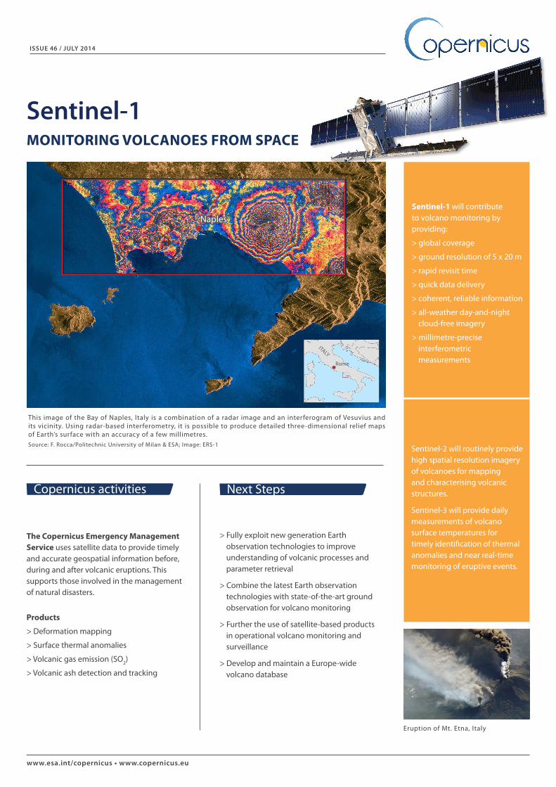
This image of the Bay of Naples, Italy is a combination of a radar image and an interferogram of Vesuvius and its vicinity. Using radar-based interferometry, it is possible to produce detailed three-dimensional relief maps of Earth’s surface with an accuracy of a few millimetres. Source: F. Rocca/Politechnic University of Milan & ESA; Image: ERS-1
www.esa.int/copernicus • www.copernicus.eu
> Fully exploit new generation Earth observation technologies to improve understanding of volcanic processes and parameter retrieval
> Combine the latest Earth observation technologies with state-of-the-art ground observation for volcano monitoring
> Further the use of satellite-based products in operational volcano monitoring and surveillance
> Develop and maintain a Europe-wide volcano database
Eruption of Mt. Etna, Italy
The Copernicus Emergency Management Service uses satellite data to provide timely and accurate geospatial information before, during and after volcanic eruptions. This supports those involved in the management of natural disasters.
Products
> Deformation mapping
> Surface thermal anomalies
> Volcanic gas emission (SO2)
> Volcanic ash detection and tracking
Copernicus activities Next Steps
Sentinel-1 will contribute to volcano monitoring by providing:
> global coverage
> ground resolution of 5 x 20 m
> rapid revisit time
> quick data delivery
> coherent, reliable information
> all-weather day-and-night cloud-free imagery
> millimetre-precise interferometric measurements
ISSUE 46 / JULY 2014
Sentinel-1MONITORING VOLCANOES FROM SPACE
Sentinel-2 will routinely provide high spatial resolution imagery of volcanoes for mapping and characterising volcanic structures.
Sentinel-3 will provide daily measurements of volcano surface temperatures for timely identification of thermal anomalies and near real-time monitoring of eruptive events.
Naples
ITALY
Rome