Monitoring of Excavation Slopes in an Open Pit...
2
The Bełchatów is a large brown coal mine in the centre of Poland, 150 km west of the capital, Warsaw. Bełchatów quarries brown coal in open pit mining with a surface of over 30 sq. km. The operator is the Polish Energy Group – Open Pit Mine Bełchatów. Due to the increasing demands for mine efficiency and slope stability in the excavation area, the customer decided in 2006 to implement an automatic monitoring system combined with a mining control system. The Polish Energy Group required a system for the automatic monitoring of slope stability in combination with a risk management system, which controls the excavation. After a consultancy period for the project, the customer selected Leica Monitoring Solution for the slope stability monitoring as it has online 24/7 data acquisition and analysis software. After this decision, the customer, mining experts and the local Leica Geosystems representatives worked closely together to design a monitoring system concept with a technical feasibility and implementation planning. Monitoring System Layout The monitoring system consists of two total stations and a small GNSS reference network to establish known stable points. The main total station TCA2003, which works permanently, is situated in a measuring container that is airconditioned and equipped with a hydraulic levelling system. The hydraulic levelling system is used for levelling the container. The stability of the container and the inside total station is determined by post- processing a GNSS baseline to a GNSS antenna at the top of the container. This GNSS antenna links the total station and the measuring container with a GNSS reference Leica Geosystems TruStory Monitoring of Excavation Slopes in an Open Pit Mine Objective Automatic deformation monitoring combined with a mining control system Customer/Institution Bełchatów http://www.kwbbelchatow.pgegiek.pl/ Date 2009 – ongoing Location Bełchatów, Poland Project Summary Instruments Leica TCA2003 Total Station Leica TCA1201M Total Station Leica Geosystems prisms Leica GMX902 GG Leica GRX1200 GG Software Leica GeoMoS Monitor / Analyzer Leica GNSS Spider Communication WLAN or GPRS Challenge Continuous deformation monitoring of the slopes’ dynamics and the salt piercing fold beneath the mining area
Transcript of Monitoring of Excavation Slopes in an Open Pit...
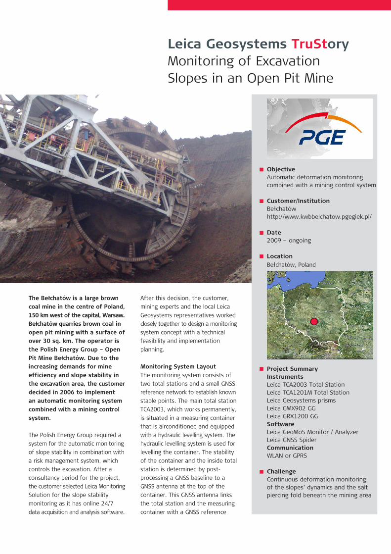
The Bełchatów is a large brown coal mine in the centre of Poland, 150 km west of the capital, Warsaw. Bełchatów quarries brown coal in open pit mining with a surface of over 30 sq. km. The operator is the Polish Energy Group – Open Pit Mine Bełchatów. Due to the increasing demands for mine efficiency and slope stability in the excavation area, the customer decided in 2006 to implement an automatic monitoring system combined with a mining control system.
The Polish Energy Group required a system for the automatic monitoring of slope stability in combination with a risk management system, which controls the excavation. After a consultancy period for the project, the customer selected Leica Monitoring Solution for the slope stability monitoring as it has online 24/7 data acquisition and analysis software.
After this decision, the customer, mining experts and the local Leica Geosystems representatives worked closely together to design a monitoring system concept with a technical feasibility and implementation planning.
Monitoring System LayoutThe monitoring system consists of two total stations and a small GNSS reference network to establish known stable points. The main total station TCA2003, which works permanently, is situated in a measuring container that is airconditioned and equipped with a hydraulic levelling system. The hydraulic levelling system is used for levelling the container. The stability of the container and the inside total station is determined by post-processing a GNSS baseline to a GNSS antenna at the top of the container. This GNSS antenna links the total station and the measuring container with a GNSS reference
Leica Geosystems TruStoryMonitoring of Excavation Slopes in an Open Pit Mine
ObjectiveAutomatic deformation monitoring combined with a mining control system
Customer/InstitutionBełchatówhttp://www.kwbbelchatow.pgegiek.pl/
Date2009 – ongoing
LocationBełchatów, Poland
Project SummaryInstrumentsLeica TCA2003 Total StationLeica TCA1201M Total StationLeica Geosystems prismsLeica GMX902 GGLeica GRX1200 GGSoftwareLeica GeoMoS Monitor / AnalyzerLeica GNSS SpiderCommunicationWLAN or GPRS
ChallengeContinuous deformation monitoring of the slopes’ dynamics and the salt piercing fold beneath the mining area
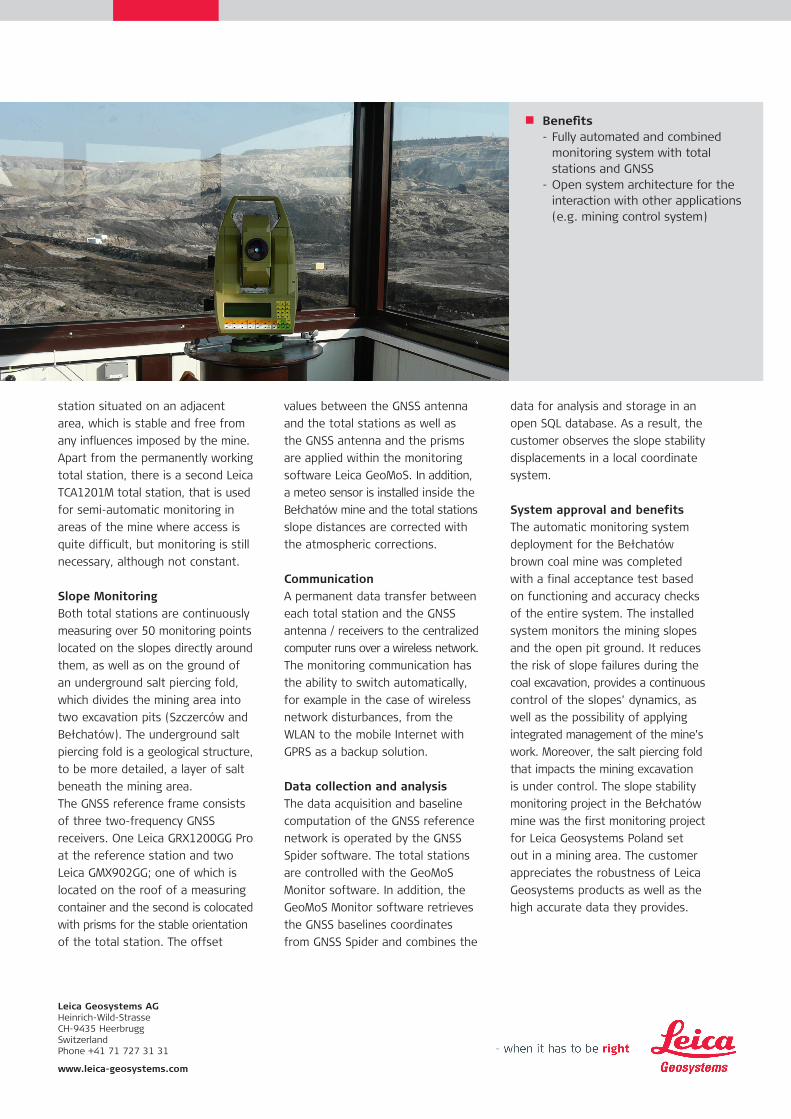
station situated on an adjacent area, which is stable and free from any influences imposed by the mine. Apart from the permanently working total station, there is a second Leica TCA1201M total station, that is used for semi-automatic monitoring in areas of the mine where access is quite difficult, but monitoring is still necessary, although not constant.
Slope MonitoringBoth total stations are continuously measuring over 50 monitoring points located on the slopes directly around them, as well as on the ground of an underground salt piercing fold, which divides the mining area into two excavation pits (Szczerców and Bełchatów). The underground salt piercing fold is a geological structure, to be more detailed, a layer of salt beneath the mining area. The GNSS reference frame consists of three two-frequency GNSS receivers. One Leica GRX1200GG Pro at the reference station and two Leica GMX902GG; one of which is located on the roof of a measuring container and the second is colocated with prisms for the stable orientation of the total station. The offset
values between the GNSS antenna and the total stations as well as the GNSS antenna and the prisms are applied within the monitoring software Leica GeoMoS. In addition, a meteo sensor is installed inside the Bełchatów mine and the total stations slope distances are corrected with the atmospheric corrections.
CommunicationA permanent data transfer between each total station and the GNSS antenna / receivers to the centralized computer runs over a wireless network. The monitoring communication has the ability to switch automatically, for example in the case of wireless network disturbances, from the WLAN to the mobile Internet with GPRS as a backup solution.
Data collection and analysisThe data acquisition and baseline computation of the GNSS reference network is operated by the GNSS Spider software. The total stations are controlled with the GeoMoS Monitor software. In addition, the GeoMoS Monitor software retrieves the GNSS baselines coordinates from GNSS Spider and combines the
data for analysis and storage in an open SQL database. As a result, the customer observes the slope stability displacements in a local coordinate system.
System approval and benefitsThe automatic monitoring system deployment for the Bełchatów brown coal mine was completed with a final acceptance test based on functioning and accuracy checks of the entire system. The installed system monitors the mining slopes and the open pit ground. It reduces the risk of slope failures during the coal excavation, provides a continuous control of the slopes’ dynamics, as well as the possibility of applying integrated management of the mine’s work. Moreover, the salt piercing fold that impacts the mining excavation is under control. The slope stability monitoring project in the Bełchatów mine was the first monitoring project for Leica Geosystems Poland set out in a mining area. The customer appreciates the robustness of Leica Geosystems products as well as the high accurate data they provides.
Leica Geosystems AGHeinrich-Wild-Strasse CH-9435 Heerbrugg Switzerland Phone +41 71 727 31 31 www.leica-geosystems.com
Benefits- Fully automated and combined monitoring system with total stations and GNSS- Open system architecture for the interaction with other applications (e.g. mining control system)