Monitoring Along the Construction Site of the Warsaw Metro ... · Dróg i Mostów Sp. z o.o.) Metro...
3
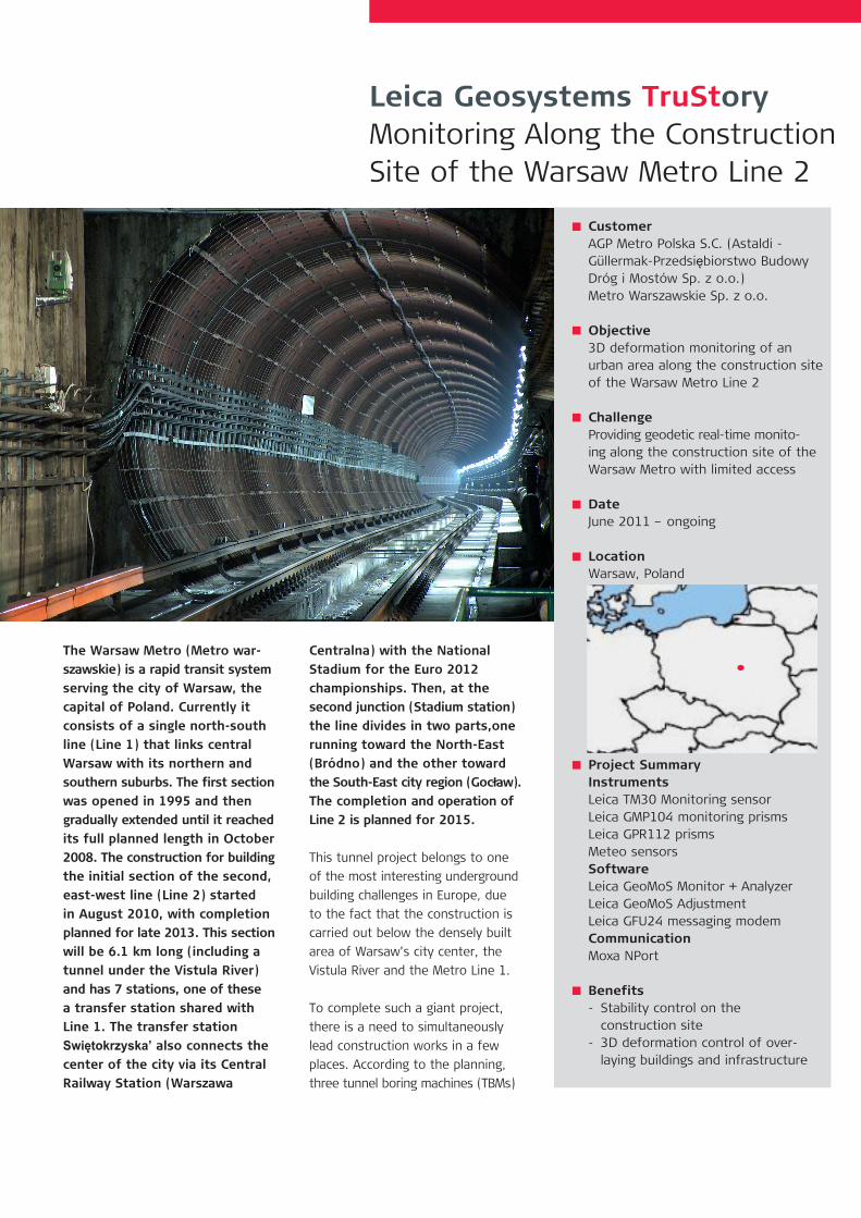
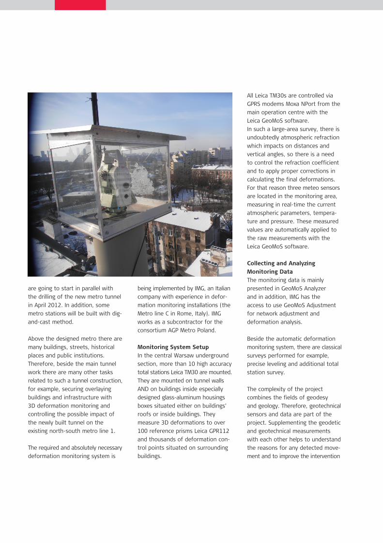
The Warsaw Metro (Metro war- szawskie) is a rapid transit system serving the city of Warsaw, the capital of Poland. Currently it consists of a single north-south line (Line 1) that links central Warsaw with its northern and southern suburbs. The first section was opened in 1995 and then gradually extended until it reached its full planned length in October 2008. The construction for building the initial section of the second, east-west line (Line 2) started in August 2010, with completion planned for late 2013. This section will be 6.1 km long (including a tunnel under the Vistula River) and has 7 stations, one of these a transfer station shared with Line 1. The transfer station Swiętokrzyska’ also connects the center of the city via its Central Railway Station (Warszawa Centralna) with the National Stadium for the Euro 2012 championships. Then, at the second junction (Stadium station) the line divides in two parts,one running toward the North-East (Bródno) and the other toward the South-East city region (Gocław). The completion and operation of Line 2 is planned for 2015. This tunnel project belongs to one of the most interesting underground building challenges in Europe, due to the fact that the construction is carried out below the densely built area of Warsaw’s city center, the Vistula River and the Metro Line 1. To complete such a giant project, there is a need to simultaneously lead construction works in a few places. According to the planning, three tunnel boring machines (TBMs) Leica Geosystems TruStory Monitoring Along the Construction Site of the Warsaw Metro Line 2 Customer AGP Metro Polska S.C. (Astaldi - Güllermak-Przedsiębiorstwo Budowy Dróg i Mostów Sp. z o.o.) Metro Warszawskie Sp. z o.o. Objective 3D deformation monitoring of an urban area along the construction site of the Warsaw Metro Line 2 Challenge Providing geodetic real-time monito- ing along the construction site of the Warsaw Metro with limited access Date June 2011 – ongoing Location Warsaw, Poland Project Summary Instruments Leica TM30 Monitoring sensor Leica GMP104 monitoring prisms Leica GPR112 prisms Meteo sensors Software Leica GeoMoS Monitor + Analyzer Leica GeoMoS Adjustment Leica GFU24 messaging modem Communication Moxa NPort Benefits - Stability control on the construction site - 3D deformation control of over- laying buildings and infrastructure
Transcript of Monitoring Along the Construction Site of the Warsaw Metro ... · Dróg i Mostów Sp. z o.o.) Metro...
The Warsaw Metro (Metro war-szawskie) is a rapid transit system serving the city of Warsaw, the capital of Poland. Currently it consists of a single north-south line (Line 1) that links central Warsaw with its northern and southern suburbs. The first section was opened in 1995 and then gradually extended until it reached its full planned length in October 2008. The construction for building the initial section of the second, east-west line (Line 2) started in August 2010, with completion planned for late 2013. This section will be 6.1 km long (including a tunnel under the Vistula River) and has 7 stations, one of these a transfer station shared with Line 1. The transfer station Swiętokrzyska’ also connects the center of the city via its Central Railway Station (Warszawa
Centralna) with the National Stadium for the Euro 2012 championships. Then, at the second junction (Stadium station) the line divides in two parts,one running toward the North-East (Bródno) and the other toward the South-East city region (Gocław). The completion and operation of Line 2 is planned for 2015.
This tunnel project belongs to one of the most interesting underground building challenges in Europe, due to the fact that the construction is carried out below the densely built area of Warsaw’s city center, the Vistula River and the Metro Line 1.
To complete such a giant project, there is a need to simultaneously lead construction works in a few places. According to the planning, three tunnel boring machines (TBMs)
Leica Geosystems TruStoryMonitoring Along the Construction Site of the Warsaw Metro Line 2
CustomerAGP Metro Polska S.C. (Astaldi - Güllermak-Przedsiębiorstwo Budowy Dróg i Mostów Sp. z o.o.)Metro Warszawskie Sp. z o.o.
Objective3D deformation monitoring of an urban area along the construction site of the Warsaw Metro Line 2
ChallengeProviding geodetic real-time monito-ing along the construction site of the Warsaw Metro with limited access
DateJune 2011 – ongoing
LocationWarsaw, Poland
Project SummaryInstrumentsLeica TM30 Monitoring sensorLeica GMP104 monitoring prismsLeica GPR112 prismsMeteo sensorsSoftwareLeica GeoMoS Monitor + AnalyzerLeica GeoMoS AdjustmentLeica GFU24 messaging modemCommunicationMoxa NPort
Benefits- Stability control on the construction site- 3D deformation control of over- laying buildings and infrastructure
are going to start in parallel with the drilling of the new metro tunnel in April 2012. In addition, some metro stations will be built with dig-and-cast method.
Above the designed metro there are many buildings, streets, historical places and public institutions. Therefore, beside the main tunnel work there are many other tasks related to such a tunnel construction, for example, securing overlaying buildings and infrastructure with 3D deformation monitoring and controlling the possible impact of the newly built tunnel on the existing north-south metro line 1.
The required and absolutely necessary deformation monitoring system is
being implemented by IMG, an Italian company with experience in defor-mation monitoring installations (the Metro line C in Rome, Italy). IMG works as a subcontractor for the consortium AGP Metro Poland.
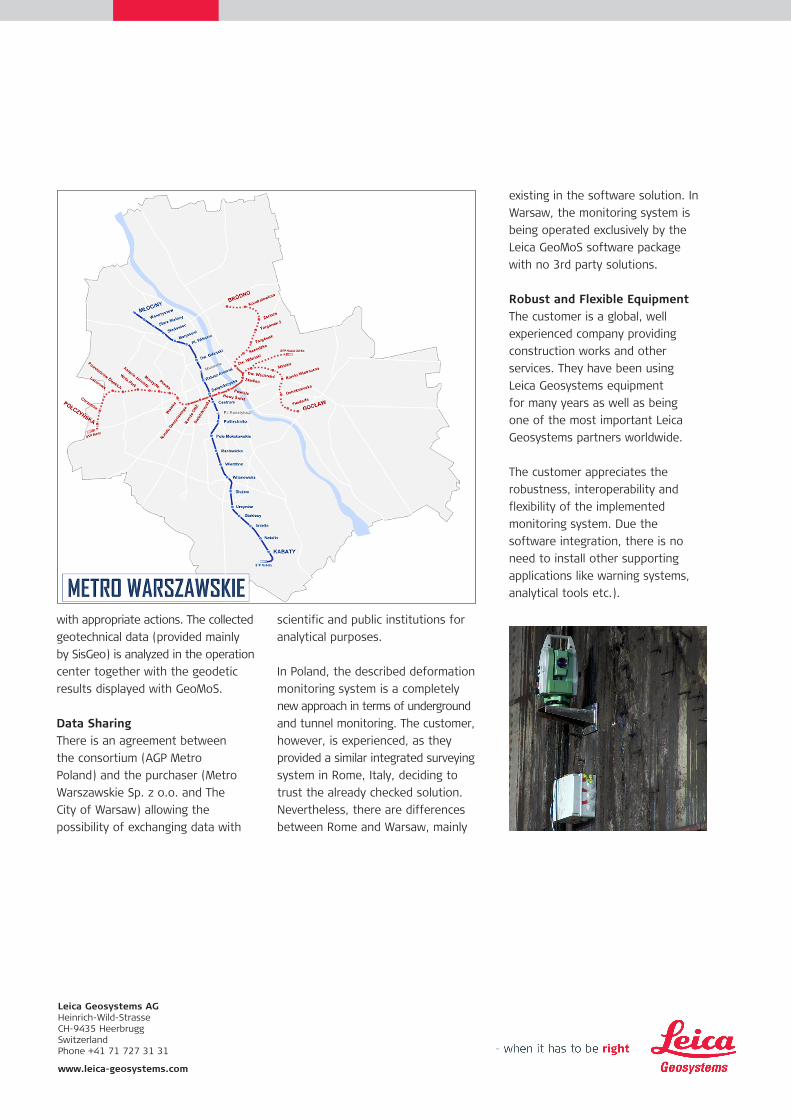
Monitoring System SetupIn the central Warsaw underground section, more than 10 high accuracy total stations Leica TM30 are mounted. They are mounted on tunnel walls AND on buildings inside especially designed glass-aluminum housings boxes situated either on buildings’ roofs or inside buildings. They measure 3D deformations to over 100 reference prisms Leica GPR112 and thousands of deformation con-trol points situated on surrounding buildings.
All Leica TM30s are controlled via GPRS modems Moxa NPort from the main operation centre with the Leica GeoMoS software. In such a large-area survey, there is undoubtedly atmospheric refraction which impacts on distances and vertical angles, so there is a need to control the refraction coefficient and to apply proper corrections in calculating the final deformations. For that reason three meteo sensors are located in the monitoring area, measuring in real-time the current atmospheric parameters, tempera-ture and pressure. These measured values are automatically applied to the raw measurements with the Leica GeoMoS software.
Collecting and Analyzing Monitoring DataThe monitoring data is mainly presented in GeoMoS Analyzer and in addition, IMG has the access to use GeoMoS Adjustment for network adjustment and deformation analysis.
Beside the automatic deformation monitoring system, there are classical surveys performed for example, precise leveling and additional total station survey.
The complexity of the project combines the fields of geodesy and geology. Therefore, geotechnical sensors and data are part of the project. Supplementing the geodetic and geotechnical measurements with each other helps to understand the reasons for any detected move-ment and to improve the intervention
Leica Geosystems AGHeinrich-Wild-Strasse CH-9435 Heerbrugg Switzerland Phone +41 71 727 31 31 www.leica-geosystems.com
with appropriate actions. The collected geotechnical data (provided mainly by SisGeo) is analyzed in the operation center together with the geodetic results displayed with GeoMoS.
Data SharingThere is an agreement between the consortium (AGP Metro Poland) and the purchaser (Metro Warszawskie Sp. z o.o. and The City of Warsaw) allowing the possibility of exchanging data with
scientific and public institutions for analytical purposes.
In Poland, the described deformation monitoring system is a completely new approach in terms of underground and tunnel monitoring. The customer, however, is experienced, as they provided a similar integrated surveying system in Rome, Italy, deciding to trust the already checked solution. Nevertheless, there are differences between Rome and Warsaw, mainly
existing in the software solution. In Warsaw, the monitoring system is being operated exclusively by the Leica GeoMoS software package with no 3rd party solutions.
Robust and Flexible EquipmentThe customer is a global, well experienced company providing construction works and other services. They have been using Leica Geosystems equipment for many years as well as being one of the most important Leica Geosystems partners worldwide.
The customer appreciates the robustness, interoperability and flexibility of the implemented monitoring system. Due the software integration, there is no need to install other supporting applications like warning systems, analytical tools etc.).